BURWELL - High Town Conservation Area - Supplementary Planning Document FEBRUARY 2008 - East ...
←
→
Page content transcription
If your browser does not render page correctly, please read the page content below
EAST CAMBRIDGESHIRE
       DISTRICT COUNCIL
       Local Development Framework

BURWELL – High Town
Conservation Area
Supplementary
Planning Document
FEBRUARY 2008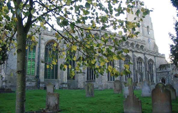
1      Introduction                                              p.2

2      Public Consultation                                       p.2

3      What are Conservation Areas?                              p.2

4      What is a Conservation Area Appraisal?                    p.2

5      Overview of the area                                      p.3

6      A brief history of the village – focussing on High Town   p.4

7      Geology and Landscape Setting                             p.9

8      Archaeology                                               p.10

9      Townscape Analysis                                        p.11
9.1    High Street                                               p.12
9.2    Mill Lane                                                 p.20
9.3    Spring Close                                              p.22
9.4    Isaacson Road                                             p.23
9.5    Manderville                                               p.23
9.6    Tan House Lane                                            p.24
9.7    Church Lane                                               p.26
9.8    School Lane                                               p.26

10     Key Characteristics                                       p.27
10.1   Topography                                                p.27
10.2   Land Use                                                  p.27
10.3   Scale                                                     p.28
10.4   Materials                                                 p.28
10.5   Open spaces and land use features                         p.30

11     Enhancement Opportunities                                 p.31
11.1   Southern Green Environs                                   p.32
11.2   Issacson Road/Mill Lane                                   p.32
11.3   Playing Fields                                            p.33
11.4   59 High Street                                            p.33
11.5   Back Lanes                                                p.33
11.6   Other opportunities                                       p.33
11.7   Public Realm                                              p.34

12     Proposed Boundary Changes                                 p.35

13     Acknowledgements                                          p.36

14     Appendices                                                p.37
       A – Maps
       B – Relevant Planning Policies
       C – Development Control Guidance
1     Introduction
1.1   Burwell has two designated conservation areas; one of which focuses
      on High Street and the other on North Street. These reflect the two
      distinct centers that have developed historically within the village linked
      by the central Causeway area. The High Town Conservation Area is
      centered on St Mary’s Church and the castle earthworks. This is the
      earliest area of settlement in the village and built up around a green at
      the southern end of High Street – the remnants of which still survive.
      The North Street conservation area developed in association with
      waterborne trade from the lodes into the Fens. Both centers were
      originally designated as conservation areas on 12 July 1974.

1.2   This document aims to fulfill East Cambridgeshire District Council’s
      duty to ‘draw up and publish proposals for the preservation and
      enhancement’ of these areas as required by the provisions of the
      Planning (Listed Buildings and Conservation Areas) Act 1990.

1.3   The document includes; a review of the boundaries of the area, a
      character appraisal, design guidance for new development, and
      policies for the management and monitoring of the area in order to
      preserve its character.

2     Public Consultation
2.1   The public consultation will be carried out in compliance with the
      Council’s adopted Statement of Community Involvement (17/10/06).

3     What are Conservation Areas?
3.1   Conservation Areas are defined as “areas of special architectural or
      historic interest, the character or appearance of which it is desirable to
      preserve or enhance”.

3.2   When a conservation area has been designated, it increases the
      Council’s controls, with planning applications judged by their impact on
      the character and appearance of the area. Greater controls over the
      demolition of buildings and structures are imposed whilst the rights that
      owners have to do works to their properties without the need to obtain
      planning permission (known as permitted development rights) are
      reduced or can be taken away. Stricter controls are also exercised over
      the design of new buildings, and owners must give the Council six
      weeks notice of their intention to carry out works to trees. Planning
      applications affecting a conservation area must be advertised on site
      and in the local press to give people the opportunity to comment.

4     What is a Conservation Area Appraisal?
4.1   There is a duty on the Local Planning Authority to determine what parts
      of their district are areas of special architectural or historic interest.
      Having established a conservation area they are also required to
      review the designation and boundaries of the area. This is to ensure
      the area is still considered to be of value and to consider whether any
      areas have been overlooked or changes have occurred which need the

                                                                                   2
boundaries to be redrawn. Any pressured for change in the area can
thus be identified and enhancement opportunities highlighted.
4.2 The appraisal document sets out the historical and economic context
for the locality and identifies what it is that makes the conservation area
of special interest. It serves to provide clear guidance on what should
be conserved in the area with specific policies devised for
Development Control to help assess planning applications made on
properties in the area.
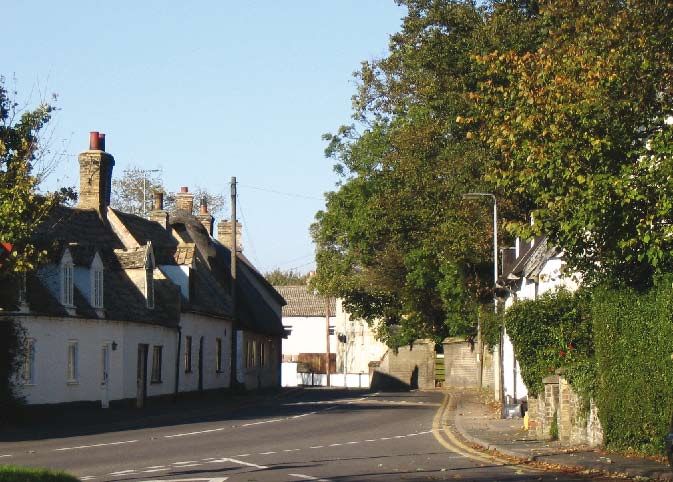
5 Overview of the area
5.1 Burwell is a long linear Fen edge village that initially developed around
the Parish Church in High Town, and the historic settlement has been
developed northwards in a series of planned expansions. The High
Street has always been the main vehicular road, around which the
village has developed in parallel with the weirs that also provided water
access. The settlement is on a ridge of land which sits proud of the
surrounding fenland. The fenland with its supply of waterfowl, fish,
peat, sedge and rushes has in the past provided valuable food and
construction resources for the village.
Views of Fens
3
5.2   The High Town conservation area has St Mary’s Church at its main
      focus , the spire being a landmark feature. The graveyard boundary
      follows the 50ft contour showing the importance of this rising land in
      providing a dryer place for settlement. Mature trees and hedgerows are
      vital to the character of this area with many of the residential roads
      leading off the High Street retaining the appearance of rural tracks.
      Modern developments have extended this part of the village east and
      west from its linear format and have begun to erode the informal rural
      feel, but glimpses of the windmill and views to open countryside have
      been retained. The location of the castle site to the southwest has
      prevented the village expanding in this direction.

                                                             Church from
                                                             southwest

6     A brief history of the village – focussing on High Town
6.1   There is evidence of continuous settlement in the area from prehistory
      onwards. By Domesday (1086) the settlement had a population of
      approximately 50 peasants, with two mills being noted. The village is
      recorded as being held by Ramsey Abbey. The manorial farmstead
      was probably on the site of The Hall, Abbey Close.

                                                                       1889-
                                                                       1890 OS
                                                                       map

                                                                               4
6.2   The village we see today is a good example of a linear medieval
      planned settlement with three distinct areas being laid out; High Town
      in the 11th century, North Street c.1350 and Newnham c.1440. These
      are surrounded by an open field cultivation system that was only
      enclosed following an Act of Parliament in 1817. High Town, until the
      early 19th century, had Pound Hill as its northern limit. It was linked to
      the other two settlement areas by a raised route way known as The
      Causeway.

6.3   The High Town conservation area still retains its original medieval
      layout, consisting of a principle street with narrow street front plots
      stretching to the back lanes of Mill Lane and Spring Close. The
      northern limit of this area is marked by Pound Hill and, until the
      nineteenth century, there were fields separating High Town from the
      northern settlement. The main focus for High Town was to the southern
      end where the spring after which the village is named, the castle,
      churches and the village green were located.

6.4   High Town was laid out on the north-south axis of the main road with
      the plots set at right angles, this settlement pattern is still visible today.
      The curve of the road to the south follows the contours of the hill on
      which the church is located and may indicate the line of a pre-Norman
      conquest defended settlement which has been largely destroyed by the
      later planned settlement.

                                                                    Burwell
                                                                    c.1800

                                                                                   5
6.5   From the 12th century the village had two churches, both within the
      High Town area, the existing Parish Church of St Mary’s and St
      Andrew’s located on opposite sides of the High Street on the present
      day site of the Old School House buildings. The later, under the
      patronage of Stoke by Clare Priory, fell into disrepair and was
      demolished in approx. 1772. The surviving church had Cambridge
      University patronage. It is described by Pevsner as “The most perfect
      example in the country of a perpendicular idea of the glasshouse”
      referring to the amount of wall to window ration produced when the
      building was extensively remodelled in the 15th century, which
      produces such a beautifully lit internal space to the building.

6.6   The castle also dates from the 12th century. Construction was
      instigated by King Stephen in 1144 to counter the rebellion of Geoffrey
      de Mandeville – who had been given the title of Earl of Essex following
      the Norman Conquest. From his base at the Isle of Ely, Geoffrey was
      devastating the surrounding countryside. In 1143 he sought to besiege
      Burwell, before the castle was completed and with its moat only part
      dug. However, he was fatally wounded in the battle and thus the
      rebellion was quashed. The castle was never finished but was later
      used by the Abbots of Ramsey. They were granted a licence in 1246 to
      erect an oratory on the site. Their influence over the village ceased in
      the 15th century with the Dissolution of the Monasteries. Today, any
      remains of buildings on the site are all below ground with the castle
      itself surviving only as a series of earthworks.

                                                               Castle
                                                               mounds

6.7   There are few surviving structures in the village that predate 1600, the
      main exception being the clunch building on the corner of Issacson
      Road which is 14th century in origin. In general the oldest properties in
      the village are detached single storey with attic space and are high
      quality timber framed with clunch block infill. In the 18th century
      rebuilding in brick was fashionable and a number of the manor
      farmhouses were upgraded in the Classical styling of this period. Brick
      continued to be the main building material in the 19th century when a
      series of impressive villas were built.

                                                                                  6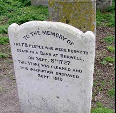
6.8    One of the most tragic events in the history of the community was in
       1727 when 80 villagers were killed in a fire whilst attending a travelling
       puppet theatre production put on it a local barn. Many of the victims
       were children. The common grave for the victims is marked in the
       churchyard by a stone showing the symbols of a winged and flaming
       heart, the Parish has recently restored this.

                                                              Gravestone

6.9    Nonconformity was a strong influence in Burwell, with a total of four
       chapels existing in the 19th century. The Baptist Chapel remains in use
       but the Congregational Chapel on High Street and the United
       Reformed Chapel on North Street have now been converted to
       alternative uses. The fourth chapel was demolished.

                                                                 Former
                                                                 Congregational
                                                                 Chapel
6.10   Economically Burwell’s fortunes were dependent on agriculture and
       quarrying. The main clunch quarries were located to the east of the
       High Town area. Burwell clunch has been quarried since Roman times
       and was used to build Cambridge Castle and several of the Cambridge
       colleges. Up until enclosure in 1815, the settlement operated an open
       field system. The fens were used for grazing in addition to providng fish

                                                                                    7
and other natural materials with the main warfs handling this produce in
       the North Street area. The arable harvest was milled in the village and
       there were originally two windmills on the high ground to the east of
       High Street, High Town mill still survives as part of the local museum.
       Associated with the grain of industry was the malting trade. The best
       surviving malting granary is on High Street adjacent to Mandeville, this
       still retaining its kiln chimney. This 12 bay clunch building dates from
       the 18th century.

                                                             Malting Kiln

6.11   By the 18th century the village was flourishing and a number of new or
       refaced buildings date from this period. The Five Bells and White Horse
       Inns date from this time and both include, as part of their complexes,
       assembly rooms, that would have served as the focus for social
       gatherings for those who resided in the fine houses fronting High
       Street. This gives an insight into the social standing of the residents at
       this time. Fine classically influenced buildings such as Ramsey Manor
       to the western side of High Street were also constructed at this time.

6.12   Burwell’s close proximity to Newmarket was one factor in the growth of
       the village as a fashionable centre. The Beacon Racecourse of
       Newmarket crossed Burwell Heath c.1660; this now forms part of the
       modern racecourse. By the 20th century most of the Heath had been
       purchased by the Jockey Club and continues to be used for racing and
       associated training gallops.

6.13   In the 19th century the village became a producer of bricks. Burwell
       whites are a buff coloured brick used widely in Cambridgeshire. A rail
       link to the town was laid out in 1883-4 with the station located in High
       Town as part of the Cambridge to Mildenhall line. This enabled the
       company of Colchester and Ball to transport the bricks nationwide by

                                                                                  8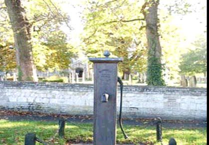
rail. By the 1960s, 10 million bricks a year were being produced.
       However, after this the industry declined. The rail link was closed in the
       late 1960s and the station was demolished. The brick works were
       closed in 1971 but have since reopened to cater particularly for the
       local market for gault tile and bricks.

6.14   Burwell was also a producer of both peat and coprolite, the latter being
       converted for use as a fertiliser. Fisons produced fertiliser locally until
       1962. Today there are a number of small commercial units in the
       village engaged in a variety of businesses, ranging from light
       engineering to computer-based employment. The population of the
       village is in the order of 5,500 people.

7      Geology and Landscape Setting
7.1    The village is located on a ridge of hard chalk (Clunch or totternhoe
       stone), which provides higher land above the surrounding fenland. This
       stone was quarried as a building material and the Parish Council, many
       of the local houses and walls are built in this material. The clunch rises
       above the 30’ contour, but the lower fenland is at, or near to sea level.
       The fens were originally peat covered but little of this remains due to
       peat digging, and the drainage and cultivation carried out from the 19th
       century onwards that has cumulatively lowered the level of the fens.
       The stream which rises near the castle site and flows north, parallel to
       the main village street formerly called Head Lode, but now known as
       The Weirs, forms a distinctive boundary between the upland and the
       fen.

                                                                  The Weirs

7.2    The Fens developed in the wash area as a result of rising sea levels at
       the end of the ice age, flooding former forested areas and depositing
       areas of marine clay. The combination of rotting vegetation of the
       former forest and slow moving water in the rivers and streams draining
       the area over several thousand years resulted in peat being formed.
       The area often flooded, thus spreading alluvium deposits that created
       fertile grazing for cattle and sheep in the flood plains.

                                                                                 9
7.3 The earliest settlements in the area were along the areas of higher
ground with easy access to fresh water and the fenland as found at
Burwell. Canals and watercourses were made for transport purposes
and some enclosure of the fens took place during the middle Ages.
However it was not until the 17th century that Vermuyden
comprehensively drained the fenland. This deep drainage enabled the
land to be used for arable cultivation. It was as late as 1846 that the
Burwell Fen Drainage Act was passed and common rights to graze on
the fens ended.
7.4 The Cambridgeshire Landscape Guidelines 1991 identified local
character areas with the fenland being a distinct category. This defines
the fens as “a landscape of contrasts and variety…The open landscape
provides distant views where the scattering of clumps and individual
trees merge together to produce a feeling of a more densely tree-
covered horizon”. The settlements have an “island” character within the
open fen setting.
Burwell across
fens
7.5 Burwell as a settlement rises from the surrounding flat fenland as a
distinct landmark feature, which is emphasised by both the tree cover
and the focal point of the Parish Church spire. The trees and hedges
serve to soften the boundary between the gardens of the settlement
and the open farmland. Common tree species are horse chestnut, elm,
oak, ash and willow with witch hazel, hawthorn and blackthorn being
hedgerow species.
8 Archaeology
8.1 Cambridgeshire County Council holds a database where all the
archaeological finds have been recorded. This is therefore a summary
of the evidence amassed to date.
8.2 Finds dating from the prehistoric period are common in the area, the
hand tools found would suggest this was an area rich for the hunting of
wildlife. Of the recorded scatter of finds the most notable is the Burwell
jadeite axe head now held in the Museum of Archaeology and
Anthropology in Cambridge. Late Bronze Age finds have been
10discovered near the Parish Church and 10+ round barrows are
recorded as being on Burwell Heath but are now sadly ploughed out.
8.3 There are several recorded Roman finds in Burwell. The distribution of
finds suggests that there may have been a villa close to the site of
Burwell Castle with another villa site recorded at nearby Reach.
Evidence of other occupation/activity around the site of the present day
village is documented, with the original digging out of the drainage
ditches or lodes attributed to the Roman period.
8.4 T.C.Lethbridge excavated an extensive Saxon cemetery of 130+
burials between 1925 and 1929 in High Town (close to Saxon Drive)
but little evidence has been found of any contemporary settlement. The
village name is attributed as having Saxon origins – meaning “the
spring by the fort”. The spring near to St Mary’s Church may be the
inspiration of this name and the church may stand on a pre-conquest
fortified site. The earliest surviving fabric of the church are the lower
two stages of the tower which date from the 12th century. Excavations
at Burwell Castle in 1935 produced evidence of a pre 12th century
settlement that had been partially obliterated by the construction of the
castle. The southern boundary of the village abuts Devil’s Dyke – a 6th
century earthwork, now a Scheduled Ancient Monument.
Devil’s Dyke
9 Townscape Analysis
As Burwell has two mutually defined conservation areas of High Town
and North Street that form distinct character areas, two separate
documents have been produced. Each area has been analysed on a
street-by-street basis.
11High Town Conservation Area
Left: 1886 OS map
Right: 1901 OS map
The castle and the Parish Church provide the focal points around
which the southern end of this area has developed. The 1886 map
clearly demonstrates how the main thoroughfare was the High Street
with the other roads serving principally the back lanes to this.
9.1 High Street
This is a very long road and as such divides into several key character
areas; the southern green, eastern commercial, eastern residential and
west.
The Southern Green
9.1.1 The southern end of High Street terminates at a green that was largely
destroyed by the construction of the railway, but a few vestiges remain
at the junction of Isaacson Road and Tan House Lane. These green
spaces provide important landscape settings to the cluster of Listed
Buildings around the green and demark the entrance to High Town
from the south.
2 High Street
129.1.2 The end stop to the High Street is at No.2, a substantial red brick
Victorian villa set in extensive landscape grounds. This building is
considered to be of local interest providing a good example of a 19th
century villa. It provides an important buffer between the village and the
open farmland beyond. It is set in extensive grounds that could face
development pressure, which could significantly impact on the locality.
The trees and hedges on the site are important landscape features.
6 & 4 High
Street -
Isaacson
9.1.3 No.6 High Street forms an imposing building as one turns the right
hand bend into High Street. This is one of the oldest buildings in
Burwell, dating from the 14th century. It was built as a range of lodgings
associated with the Knights Hospitallers but is now one house. It is built
of clunch that remains unpainted or rendered so that the various
alterations to the exterior over the centuries can be seen. Formerly
known as the Old Manor House it was owned by the Isaacson’s in the
18th and 19th centuries, that have given their name to the adjacent
street. This property together with the similarly imposing 12 bay clunch
maltings to Manderville provide the ‘gateway’ to the historic village at
the eastern end of the former green.
7 & 9 High St
and 15-19
High St
9.1.4 Moving north up High Street the road is lined to the eastern side with a
row of painted clunch cottages one storey with attic rooms running from
No.7 to No.21. These date from the 17th and 18th centuries and sit hard
13on the back of pavement, contrasting with the more open area of the
green to the south and the graveyard of the Parish Church to the north.
View north
up High St
from Green
9.1.5 On the western side of the street No.12, another 17th century cottage,
matches the style and form of the cottages opposite and forms an
important ‘gateway’ focal point at the entrance to the High Street.
Together with the wall to the vicarage this forms a hard edge to the
road restricting the views until the more open aspect of the graveyard.
The building has been subject to modern alterations and would benefit
from enhancement.
12 High St
Age Predominantly 18th-19th century
Wall Materials Painted clunch and brick
Roof Materials Thatch, slate and clay tiles
Windows/Doors Predominantly timber but some PVCu (14 High St) and
modern styles of windows and doors
Scale 1 plus attic
Key Features Window shutters, casement timber windows, boarded
doors, chimneys
14High Street: Eastern Commercial
26 High St
9.1.6 There is a small group of commercial buildings on the eastern side of
the road, including Nos.20-26 High Street. The buildings are all
detached and have shop fronts with long rear ranges, most of which
contain residential units behind the commercial frontage. The shop
fronts are traditional timber and date from the late 19th or early 20th
century. No.20 is Grade II listed and formerly had a traditional Hovis
sign to the front elevation that has since been removed. The
replacement of the shop fronts and associated signage with modern
details would adversely impact on the character of this group.
Age 19th / 20th century frontages with older buildings incorporated
Wall Materials Brick/clunch, painted or rendered
Roof Materials Slates and traditional pan tiles and modern concrete tiles
Scale 1-2 storey
Key Features Traditional timber shop fronts
High Street: Eastern residential (evens)
Crownland
Farmhouse 28
High Street
159.1.7 The buildings north from Crownlands Farm, Nos.28-88 High Street
(The Crown Public House) is predominantly residential properties. Only
Crownlands Farm retains the traditional street pattern of the main
building fronting High Street, with the plot running back to Mill Lane
where the outbuildings were located. At Crownlands Farm a very fine
dovecote and barns still exist to the east of the main house.
9.1.8 In the 20th century the rear part of the burgages have been extensively
developed for housing fronting Mill Lane, an this has eroded the
historic relationship of the High Street properties to this back lane.
9.1.9 The pattern of development to High Street is one of detached units,
either gable end or length ways to the road, the terrace of 36-42 High
Street forms an exception to this. This terrace dates from the 19th
century and all the units retain their original timber sash windows and
brick front elevations. Some of the units have had front porches added
which has lead to the alteration of the appearance of the main
elevation.
36-42 High
Street
9.1.10 The group of buildings comprising the Old School are on an elevated
position above the road. These have a gateway function with the
collection of buildings opposite that make up 23 High Street. They sit
either side of the road where it widens at the entrance to the
churchyard thus accentuating the focal point of the church in the vista
south down High Street.
Old School,
High Street
169.1.11 The residential properties on this side of the street are generally
positioned close to the road with little or no front gardens, although
some modern infill has departed from this pattern. To the southern end
of the street, the Five Bells Public House (Grade II Listed) has a
commanding presence to the street with the later 19th century
assembly room section being closest to the road.
Five Bells
Public House
9.1.12 The Five Bells is an eighteenth century inn with slightly later assembly
room. It has its original fenestration and a fine main entrance door
case. The Crown Public House to the northern end of the street is of a
similar age but is not listed. It also retains its timber sash windows and
is important that these units do not dominate the street scene with
excess signage and illumination.
Memorial Hall
from High St
9.1.13 The Gardner Memorial Hall dated 1914 gives a break in the
development and is an interesting arts and crafts influenced building
which retains its original windows. The impact of this large building and
its associated car parking is softened by a row of trees running along
the High Street boundary.
17Age Mainly 18th-19th century
Wall Materials Clunch and brick – painted or rendered
Roof Materials Clay tiles – pan and plain
Windows/Doors Mix of casement and timber sash windows. Dormer windows at
first floor on 1.5 storey buildings
Scale 1 plus attic – 2 storey
Features Dentil course detailing. Chimneystacks
High Street: Western Side (odds)
9.1.14 The historical pattern of the development on the western side of the
street has been largely eroded by 20th century development. The 1886
map shows that this also had a back lane called Dark Lane. Part of this
still remains but the majority has been incorporated into Spring Close
and modern cul-de-sacs.
Ramsey Manor,
37 High Street
9.1.15 The Grade II listed Parish Church dominates the views down the High
Street. It is constructed of fieldstones and flint with limestone
dressings. The main fabric is fifteenth century, built after the first phase
of construction of King’s College Chapel, Cambridge using the same
master mason. The trees to the graveyard provide an important
landscape setting to the church and the streetscape.
View south
down High St
to Church
189.1.16 No.23 High Street follows the curve in the road at its junction with
Spring Close. This Grade II Listed Building forms an important setting
to the small green area at the main entrance gates to the graveyard.
23 High St
9.1.17 The graveyard has retained its gravestones including some very fine
18th century head stones. The small green at the entrance to the
churchyard includes a former village pump that forms the focus of this
small green space.
Pump adjacent
to church
9.1.18 The dwellings on this side of the road are generally detached and sit
close to the road; there are also a number of modern infill units. The
properties have a mix of window styles, but generally the window
frames are timber, with exceptions at No.25 and No.53 High Street.
There is a pinch point in the street with No.29 High Street having a
direct relationship with the Five Bells Public House. The appearance of
No.29 with its cantilevered, chamfered entrance doorway indicates that
it was formerly in commercial use, but is now in residential use.
19Age 20th century with a few remaining 18th and 19th century buildings
Wall materials Brick and painted clunch
Roof materials Modern concrete tiles and clay tiles
Windows/Doors Predominantly timber – some PVCu and modern styles
Scale 1 plus attic – 2 storey
Key features Decorative brick detailing, dormers, chimneystacks, open space
focussing on the church
9.2 Mill Lane
9.2.1 This is the historic back lane to the properties fronting the eastern side
of the High Street. It is on slightly rising land so that at various open
points views down to the High Street are afforded. The roofline of the
High Street and Mill Lane buildings is therefore important. This remains
a very narrow land. The northern section has been metalled and a
series of post war cul-de-sacs feed off the lane. To the south it remains
unsurfaced and some of its original character remains. The historic
development in this area is associated with the lime quarrying and
grain milling carried out here. One of the village’s two tower mills still
survives within an estate of bungalows. Views of the mill are gained
from Mill Lane.
View of mill
from Mill Lane
9.2.2 Much of the development along the lane is 20th century. The key
buildings of interest are the former Congregational Chapel that
surprisingly is not listed. This very fine clunch and brick building has a
commanding presence on both Mill Lane and High Street. Now a
dwelling the ‘rear’ garden forms an important break in the development
along the High Street. The building itself is built hard onto Mill Lane and
is on the inner curve of the road thus in the views up the road looking
north the structure forms an important focal point. It retains its original
windows and doors and the insertion of a floor has not detracted from
this.
209.2.3 When journeying from the south the Parish Church forms the focal
point with the spire glimpsed over the rooftops of the High Street
properties.
View of church
from Mill Lane
9.2.4 The section of Mill Lane south of School Lane retains a rural character.
The Listed barn on the corner of this road contributes to the change in
character at this junction.
View down Mill
Lane
9.2.5 The hedging and grass verges are important to the character of the
road and help soften the impact of the new estates to the east and the
infill development along the lane. A number of 19th century cottages
associated with the former lime quarries are located to the eastern side
of the lane – the name of one terrace: Stonefield Cottages, giving a
clue to the former employment of their occupants in the nearby clunch
quarries.
21Stonefield
Cottages, Mill
Lane
Age 19th – 20th century
Wall materials Brick and painted clunch
Roof materials Clay pantiles and modern tiles
Windows/Doors Mainly timber windows – modern units have both painted and
stained timber windows with some modern replacements
Scale 1 to 2 storey
Key features Narrowness of lane. Enclosure by brick/clunch walls and
hedges. Vistas down road of the church/former chapel/mill.
Chimneys
9.3 Spring Close
9.3.1 This road was also a back lane. Today it is principally a service road to
the post war housing developments that have in-filled behind the
western side of the High Street. The only unit of any historic interest is
the detached building of No.1 Spring Close, which is a 19th century
building with modern alterations.
9.3.2 Spring Close gives access to the Castle; the rolling grassed earth
works of which forms an area of open space on the southern side of
the road. Views to the Scheduled Ancient Monument are afforded from
the Close that forms the limit of the village at this point.
Castle mounds
229.4 Issacson Road
9.4.1 This road links Mill Lane to the High Street and terminates at the green.
The majority of the road is post war expansion. Only two buildings on
either side of the road where Mill Lane intersects fall within the
enlarged conservation area. No.10 is a single storey cottage with a tin
roof but was possibly once thatched. This retains simple casement
windows and a boarded door. It remains a rare example of an
externally unmodernised single storey former lime quarry workers
cottage.
10 Issacson
Road
9.4.2 No.9 Issacson Road has recently been restored; it’s a small scale, 1.5
storey building of rubble clunch with a pantile roof. It is located to the
rear of the Grade II Listed building of Issacsons and forms part of the
rear setting of this building.
9 Issacson
Road
9.5 Manderville
9.5.1 This road is dominated at its southern end by the complex of buildings
around the Manor House. This 17th century building retains a series of
outbuildings including a dovecote, aisled barn and the maltings. These
were formerly associated with the Manor House but are now in
separate ownership and uses. All the buildings are separately listed
and all are Grade II listed.
23The Manor
House
9.5.2 The tiled roof of the malt kiln forms a very distinctive feature adjacent to
the road and a strong reminder of the importance of this industry in the
village during the 18th and 19th centuries.
Elevation of
malting to
Mandeville
Age 18th – 20th century
Wall materials Clunch, brick and weatherboarding
Roof materials Gault and red clay tiles, thatch and slate
Windows/Doors Mix of styles and forms including timber and metal predominantly
modern casement windows including night vent styles
Scale 1.5 – 2 storey
Features Malking kiln as feature. Hedges and banks
9.6 Tan House Lane
9.6.1 This narrow road retains a very rural character with much of it being
hedge and tree lined. The houses and bungalows along the road are
set well back from the road, in large plots and are well screened by the
trees and hedges. The landscape is very important to the character of
this part of the village.
24Tan House Lane
9.6.2 All the buildings apart from Tan House are 20th century in date. Tan
House is a Grade II listed, 17th century farmhouse that still stands apart
from the main settlement.
The Tan House
9.6.3 There are views across the playing fields from the lane. Although these
buildings are located outside the boundary of the conservation area,
any redevelopment of the Sports and Social club could have a
significant impact on the setting and appearance of Tan House Lane.
The clubhouse is considered to have no architectural or historic interest
to warrant retention of this rather esoteric building.
Sports and social
club
25Age Mainly 20th century
Wall Materials Brick
Roof Materials Modern tiles
Windows and Modern but predominantly timber
Doors
Scale 1 – 2 storey
Features Hedges to banks either side of the road. Low density
development in large plots. Narrowness of road. Views out over
playing fields.
9.7 Church Lane
9.7.1 Church Lane is a small cul-de-sac of two properties leading to the
churchyard. It provides an important view to the church that is framed
by the two properties on either side of the lane. The western unit, Rose
Garden Cottage is a thatched unlisted cottage with timber casement
windows that dates from the late 18th or early 19th centuries. This
building is considered to be of local interest. Opposite is No.2; a
modern brick building with a slate roof with timber casement windows.
Rose Garden
Cottage, Church
Lane
9.8 School Lane
9.8.1 A short lane linking Mill Lane to High Street containing only three units.
The former school complex (Grade II listed), at the junction with High
Street, forms the most dominant visual feature to the lane. Although the
frontage to School Lane is the rear elevation of these buildings the
same level of decorative detailing has still been applied to the windows
and elevations.
9.8.2 On the opposite side, is No.3, a 19th century villa. This has been
significantly altered with PVCu windows and a 20th century front door.
The remaining two properties of 4 and 6 School Lane are both 20th
century buildings built in buff brick with modern timber casement
windows. All three properties are two storeys in scale.
26Rear of
School
House,
School Lane
10 Key Characteristics
The positive elements that are the essence of what makes this part of
the village special are considered in more detail below.
10.1 Topography
The prominent position of the church in the townscape is a constant
reminder that the village sits on a ridge of higher land above the fen
land. The views from Mill Lane down to the High Street give the
clearest indication of the different land levels. Views from this road over
the rooflines of the properties fronting High Street make it imperative
that the scale and form of roofs are controlled to ensure these views
are not obstructed and that the local clay tile vernacular materials are
used. The church and the windmill form the two focal points of this part
of the village with important glimpses and vistas of both structures
being afforded from both High Street and Mill Lane.
22 Mill Lane
10.2 Land Use (see map 1 at end of document)
The predominant land use in this part of the village is residential, but
close to the churchyard, there is an important cluster of retail uses,
which retain traditional shop fronts and signage and are therefore of
special interest and worthy of retention.
27The high level of residential use means that the majority of the
buildings can currently be altered using ‘permitted development rights’,
such as the alteration of windows.
10.3 Scale
The buildings in High Street tend to be located close to or on the back
edge of the pavement, giving a very tight enclosure to the road. The
buildings are generally 1.5-2 storeys in height and have a cottage scale
to them, with a few notable grander exceptions in particular the former
manor house, institutional or industrial buildings. The High Street has a
noisy, busy nature to it and can be difficult to cross due to the level of
traffic movement. By contrast the back lanes on both sides of the High
Street are far more tranquil and have a distinct rural character. The
buildings are less formally arranged and are, in the main, set back from
the road in their plots with a mix of outbuildings associated with the
cottages. On Mill Lane the scale is generally single storey to 1.5
storeys, whereas the scale of the properties fronting the streets on the
western side of High Street, such as Manderville are 1.5 to 2 storeys.
10.4 Materials
Walling
The predominant walling materials are brick and clunch and is usually
painted, rendered or limewashed. Some of the rendered cottages also
conceal timber framing or a mix of timber framing with clunch or brick infilling.
The brick is principally the locally made Cambridgeshire gault white but with
some red bricks used, either as decoration to give contrast to the windows
and eaves or, for some of the more prestigious buildings.
Roofing
Until the 19th century roofs were of thatch or local hand made clay roof tiles,
both plain and pan tiles. After the arrival of the railway slates were used on
many buildings.
Roof forms
Most buildings have pitched roofs, often hipped and many have dormer
windows. The oldest buildings have very steeply pitched roofs usually to
accommodate a thatch covering.
52 High St
28Architectural Details
Particular details of note are the use of dentil details to the eaves and parapet
walls. One and half storey buildings generally have gable toped dormer
windows with rendered side cheeks. Gable ends tend to have lay board
details.
Chimneys
These are an important part of the roofline and the majority of houses still
have chimneys. Many older properties have substantial and decorative stacks
that contribute to the street scene.
50 High St
Windows
The older traditional cottages have either multi-pane casement or horizontal
sliding sash windows. The 18th and 19th century buildings have vertical sash
windows. The majority of houses have retained their traditional framed
windows.
Front Doors
There is a host of door styles. Some of the later villas in particular, along High
Street, have interesting front porches or door hoods that contribute to the
street scene.
Textures and colours
The use of render has resulted in a wide pallet of colour wash finishes. The
brick buildings are predominantly buff in colour. The extensive use of red clay
tile forms a unifying feature, with a mix of textures produced from the use of
both pan and plain tiles.
Location on the plot
Most of the properties sit parallel to the street and, on High Street and Mill
Street, are either directly on the back edge of the pavement or behind a small
front garden area. On Tan House Lane and Manderville, the pattern is more
random with units set back within the plots with a less direct relationship to the
street.
29Boundary walls
Brick or clunch walls are the predominant materials used to enclose the sites
to the High Street and there are few railings. In the back lanes, hedging and
fences are more commonly used. The loss of such features to accommodate
development or to form vehicular parking on site has a negative impact on the
street scene.
Church from
South
10.5 Open spaces and land use features
10.5.1 At the southern end of the High Street the castle earthworks, the
greens and the churchyard form important open spaces, all of which
have a number of fine specimen mature trees or shrubs. This soft
landscaping contributes significantly to the street scene and the setting
of the Listed Buildings located here. It serves to emphasise the rural
character of the village, particularly at the southern end of High Town
where it helps grade the built fabric into the open countryside beyond.
10.5.2 At the northern end of High Town both open spaces and trees are less
common, although the sites of the Memorial Hall and the Former
Congregational Chapel garden are notable exceptions with the
important landscaping to the road frontage.
10.5.3 The back lane areas retain their rural character, principally due to the
roads being lined by grass verges/banks and mature hedgerows.
Although there are no working farms within the conservation area, the
survival of former agricultural buildings such as The Manor House and
Crowland Farmhouse in High Street retains the agricultural character of
the area.
Views
10.5.4 The linear nature of the village affords views up and down the main
roads. There are few views from within the conservation area to open
countryside – the main points are at Spring Close over the castle site
and at the end of the track adjacent to No.2 High Street.
30View down Mill
Lane
11 Enhancement Opportunities (see map 2 at end of document)
The following list is considered to be the current pressures on the locality.
It is not in any order of importance:
• Loss of traditional timber framed windows;
• Development of back land sites;
• Development of non-listed properties to give higher density and
develop frontages to back lanes;
• Loss of enclosing hedges and verges and un-tarmaced surface of
back lanes;
• Loss of traditional outbuilding structures;
• Use of non-traditional materials;
• Employment of non-traditional form of features such as dormer with
horizontal rather than vertical emphasis;
• Loss of traditional materials such as handmade tiles or thatch;
• Upgrading of commercial shop fronts;
• Addition of front porches;
• Installation of satellite dishes;
• Loss of chimney features;
• Building of new buildings which do not have traditional features
such as chimneys, dormers or are out of scale;
• Loss of boundary walls and hedges to accommodate on site
parking.
1a Manderville
31Having identified these pressures on the area, areas for enhancement
are identified below and policies contained in the Development Control
Guidance Policies at the rear of this document aim to address the
potential impact of these on the locality.
Five main enhancement areas have been identified as follows:
11.1 Southern Green Environs
11.1.1 The greens form the entry point into High Street from the south and are
important to the setting of a number of listed buildings. There is an
opportunity to review the paving materials; street furniture and
landscaping of the greens to ensure these enhance the locality. There
are two properties at the entrance to High Street which are in need of
upgrading, No.5 High Street is completely covered in plant growth and
its state of repair needs to be established to ascertain if this important
element in the group of cottages can be restored to contribute to the
street scene positively. No.12 High Street was formerly a thatched
building, but now has a tin roof. The reinstatement of the thatch would
significantly enhance the setting of the listed cottages opposite. The
reinstatement of traditional windows and features where there is clear
historic evidence for their existence – such as wooden window shutters
– on the group of thatched cottages opposite should be encouraged.
11.2 Isaacson Road / Mill Lane
11.2.1 This marks the entry into Mill Lane and as such it is important to
reinforce the planting at the corner of this lane to emphasis the rural
character of this part of the road. Reinforcing the existing boundary
hedging or walls and retention of a non-tarmac surface are considered
to be essential. Retention of the vistas to the rear of 6 High Street are
important given the architectural interest of the rear elevation of this
building.
10 Isaacson Rd
11.2.2 No.10 Isaacson Road remains a rare survival of a very modest single
storey clunch cottage associated with the near by lime workings. It is
identified as being of local interest and consideration should be given
32to putting this forward for statutory listing. Research into the building
with a view to reinstating any lost historical features is needed.
11.3 Playing Fields
Pavillion of St
Regis Sports and
Social Club
11.3.1 The modern sports club building forms a very alien feature in the
context of Tan House Lane. Its boarded up form detracts from the
conservation area. The playing fields are an important buffer to the
modern expansion of Burwell to the southwest and the old village.
Sensitive redevelopment of this site with regard to the character of the
adjacent conservation area would enhance this locale.
11.4 59 High Street
11.4.1 This commercial building forms an important end stop feature to the
northern end of High Street. The rear of the building is however in a
poor state of repair and detracts from the street scene. The building is
of local interest and there is an opportunity to repair the building to
ensure its long-term retention and a visual enhancement to the locality.
11.5 Back Lanes
11.5.1 The character of Mill Lane in particular changes from an un-tarmaced
tree/hedge lined lane with grass verges and banks at the southern end
to a modern estate access road with open gardens and tarmac at the
northern end. It is critical for the preservation of the character of the
area to ensure the visual appearance of the southern part of Mill Lane
is not altered to mirror the format of the northern section that has lost
its rural character and appearance. Similarly, the hedges and banks of
Tan House Lane and Manderville need to be preserved and enhanced.
Where possible opportunities to reinstate hedging and trees need to be
explored, for example, to the Mill Lane frontage of the Memorial Hall to
assist in the screening of the car park area. Existing tarmac areas
could be resurfaced in more appropriate materials and the un-surfaced
areas should remain in an ‘unmade’ format.
11.6 Other opportunities
11.6.1 Given the importance of the museum just outside the conservation
area, and the castle, as visitor attractions, there is an opportunity to link
33into these resources and consideration should be given to a village trail
through the conservation area, identifying the key buildings and
structures of interest. This would need to be signposted or a footpath
trail installed. Additional interpretation poles or boards could be
erected, for example within the churchyard or on the greens, to give
information and history of the respective areas. A leaflet about the trail
could be made available from the museum of church.
11.7 Public Realm
11.7.1 The main High Street is a classified rod with pavements along both
sides and is tarmaced. As this is a major through route there is little
opportunity for traffic calming. However, there is scope for enhancing
the setting of groups of Listed Buildings such as those around the
greens and the churchyard, by an upgrade of the surfaces and street
furniture in these areas.
11.7.2 The residential back lanes are narrow and hedge/bank lined. It is
important that the laying of tarmac on the roads that have not been
upgraded be resisted as the gravel surface contributes to the character
of the area.
Signage
11.7.3 Burwell’s streets are not cluttered with road signs. A signage/village
trail to highlight the key heritage assets of the mill/museum, the
church/churchyard, the castle, the former manor houses and the
maltings is suggested earlier. Some interpretive material of these
assets should also be considered – this is already well provided for on
the castle site. Other local features such as the remains of the village
green, the village pump, the gravestone to the tragic fire and former
school are features of interest which should be retained and high-
lighted although interpretation is not desirable.
Street lighting
11.7.4 There is a mix of street light styles and the height of the lamps varies.
Individual streets would benefit from the use of only one style of lighting
column, although the choice of lamp stand could vary between the
High Street and the back lanes to emphasise the differing character of
these streets.
Street furniture
11.7.5 There are some existing benches on the green areas and near the
village pump to the north of the churchyard main entrance gates.
Consideration of whether these are in the best locations and whether a
particular colour needs to be used for all public street furniture needs to
be considered. A street furniture audit is recommended to be
undertaken. As part of this an assessment of the design, materials and
colour finish of the furniture can be made and a range of items
identified for specific use in this location.
3411.7.6 There are a number of modern bus shelters that are in a green
coloured finish. These are not considered to positively contribute to the
street scene and a higher standard of design and materials would be of
benefit.
11.7.7 The red telephone box to the southern green contributes to the setting
of this area and efforts should be made to retain this feature, as it is not
listed.
11.7.8 A standard square black plastic bin appears to be the general format
for public rubbish bins in the village.
12 Proposed Boundary Changes
The following amendments are proposed having considered the 1974
boundaries of the conservation area:
12.1 Enlargement of the southern boundary: to include the small green area
adjacent to the entrance to Tan House Lane and the parcel of land
south of the main green including No.2 and No.10 Isaacson Road.
Justification: These units provide an important setting to the green and
a buffer between the settlement and the open countryside. Both
buildings are of historic interest. The landscaped grounds to No.2 are
important to the character and appearance of this part of the village
and contribute to its rural character.
12.2 Enlargement of eastern boundary to south: to include both sides of Mill
Lane to ensure trees and hedges and Stonesfield Cottages and
Millfield are incorporated.
Justification: The landscaping on this side of the lane is presently
excluded but contributes significantly to the appearance of the lane and
buffers the new housing beyond. Stonesfield Cottages and Millfield are
considered to be of local interest and to contribute to the conservation
area.
12.3 Reduction of eastern boundary north: to remove the modern properties
to the western side of Mill Lane.
Justification: These are all modern dwellings that are not considered to
preserve or enhance the character or appearance of the conservation
area.
12.4 Reduction in western boundary: to exclude a series of modern infill
properties.
Justification: These are considered to lack the character of the
traditional properties in the locality and consequently do not preserve
or enhance the character or appearance of the conservation area.
12.5 Enlargement of northern High Street: to include two areas that contain
buildings of local interest and that contribute to the character and
appearance of the conservation area. No.59 forms an important focal
point and end stop to the northern end of High Street.
3513 Acknowledgements
The historical and archaeological background has been compiled using
the following sources:
1. The Cambridgeshire Historic Environment Record
Cambridgeshire County Council
Box ELH 1108
Shire Hall
Cambridge, CB3 0AP
Email: arch.her@cambridge.gov.uk
2. A History of the County of Cambridgeshire and Isle of Ely Volume X
(North east Cambridgeshire) 2002
3. The Inventory of Historical Monuments in the County of
Cambridgeshire Volume 2 (North east Cambridgeshire) RCHME
pages 16-47
4. The Buildings of England: Cambrigeshire
Nicholaus Pevsner. Yale University Press, 2nd edition 1970
5. Ordnance Survey Maps
Burwell Museum
(The Fen Past Screening Bureau has an archive relating to fenland
life.)
Box RES 1013
Shire Hall
Cambridge, CB3 0AP
Email: fenpast@cambridge.gov.uk
36APPENDIX A
MAPS
37Land Use
This map is reproduced from Ordnance Survey material with the permission of Ordnance
Survey on behalf of the Controller of Her Majesty's Stationery Office. Crown copyright.
Unauthorised reproduction infringes Crown copyright and may lead to prosecution or civil
proceedings. East Cambridgeshire District Council Licence Number 100023279.
East Cambridgeshire
District Council
Scale: 1:2,500
Date: 30/10/2005
Residential Open green space Public / Community Commercial Industrial Proposed new boundaryFive main enhancement areas have been identified as follows:
This map is reproduced from Ordnance Survey material with the permission of Ordnance
Survey on behalf of the Controller of Her Majesty's Stationery Office. Crown copyright.
Unauthorised reproduction infringes Crown copyright and may lead to prosecution or civil
proceedings. East Cambridgeshire District Council Licence Number 100023279.
4
5
2
5
3
1
East Cambridgeshire
District Council
1 Southern green environs 2 Issacson Road / Mill Lane 3 Play fieldings 4 59 High Street 5 Back Lanes Proposed new CA boundaryAPPENDIX B
RELEVANT PLANNING POLICIES
38Cambridgeshire Structure Plan (adopted October 2003)
P1/2 Protection of sites of archaeological, historic or architectural value
P7/6 Local Authorities will protect and enhance the distinctiveness of the
historic built environment.
East Cambridgeshire Core Strategy (adopted October 2009)
This section summarises the main Core Strategy policies that are relevant to
the conservation areas.
Policy EN 2
Design
All development will be designed to a high quality, reinforcing local
distinctiveness. Design which fails to have regard to local context and does
not preserve or enhance the character, appearance and quality of an area will
not be acceptable.
New development proposals, extensions and alterations to existing buildings
and structures will be expected to:
a. Have regard to the East Cambridgeshire Design Guide;
b. Incorporate the sustainable construction principles contained in Policy
EN3;
c. Make efficient use of land while respecting the density, character,
landscape and biodiversity of the surrounding area;
d. Be developed in a comprehensive way, avoiding piecemeal
development;
e. Retain existing important landscaping and natural and historic features
and include landscape enhancement schemes that are compatible with
the Council’s Landscape Guidelines for recreation and biodiversity;
f. Ensure that the scale, massing and materials of buildings relate
sympathetically to the surrounding area;
g. Provide structure by making use of existing views, vistas and
landmarks and creating new ones;
h. Create safe environments addressing crime prevention and community
safety;
i. Make a clear distinction between public and private spaces, and
enhance the public realm;
j. Ensure that places and buildings are accessible to all, including the
elderly and those with impaired mobility;
k. Provide enclosure to street and spaces through the grouping,
positioning and height of buildings and landscape features, and road
layouts;
l. Incorporate the highway and access principles contained in Policy S6;
m. Ensure that car parking is discrete and accessible and provided in
accordance with Policy S7;
n. Provide adequate waste and recycling storage/collection areas;
o. Where appropriate, contain a variety and mix of uses, buildings and
landscaping;
39p. Ensure there is no significantly detrimental effect on the residential
amenity of nearby occupiers, and that occupiers of new dwellings are
provided with acceptable residential amenity;
q. Ensure that there is no detrimental effect on the appreciation of Ely as
an historic cathedral city in the quality of the approaches and the
quality of views of the cathedral distant and close to.
The Council may require the submission of development briefs for certain
proposals, and will notify developers of this requirement at an early stage in
the conception of proposals.
EN2 - Design
• Well-designed, safe and attractive new development that respects its
surroundings can help to raise the quality of the built environment and
have a significant impact on everyday life. Good design is a key
element in sustainable development and it is a strongly held aspiration
of the Council to raise the standard of design in all proposals to assist
vitality, and create a ‘sense of place’ in communities and
neighbourhoods.
• The Government requires Design and Access Statements to be
submitted with most planning applications. These Statements are
intended to demonstrate how a proposal is functional, attractive and
accessible to all. Comprehensive guidance on the format and content
of a Statement is provided on the Council’s website. Further
information on design can be found in ‘Building for Life’ published by
CABE, which includes advice on character, public space, design and
construction, and the surrounding environment and community. Also
helpful in street design is the Government publication ‘Manual for
Streets’ which gives advice on the creation of high quality residential
streets. The Council encourages developers to incorporate these
principals in their proposals. Developers are also encouraged to go
beyond minimum access standards contained in Building Regulations
to provide higher standards of accessibility for all within public spaces
and individual buildings.
• Development must be of the appropriate scale, design and materials
for its location and conform to the design principals set out in the policy
below. All new buildings and spaces must enhance and respect their
surroundings and contribute towards local identity, whilst securing and
maintaining a high level of general amenity for residents and workers in
the district. The particular importance of design in areas of historic
conservation is detailed in Policy EN5.
• The importance of new developments complementing and relating to
their surroundings, whilst being safe and accessible to all, is
established in the strategic objectives of the Core Strategy. The
objectives also seek to mitigate the impacts of climate change, and the
environmental performance of new buildings is addressed in Policy
EN3 ‘Sustainable East Cambridgeshire Core Strategy construction and
40You can also read