State Party Report on the state of conservation of the Greater Blue Mountains Area World Heritage property (Australia) - Property ID 917 In ...
←
→
Page content transcription
If your browser does not render page correctly, please read the page content below
State Party Report on the
state of conservation of the
Greater Blue Mountains Area
World Heritage property
(Australia)
Property ID 917
In response to the World Heritage
Committee decision 43 COM 7B.2
For submission by 1 December 2020
State Party Report on the state of conservation of the Greater Blue Mountains Area (Australia)

© Commonwealth of Australia 2020

Ownership of intellectual property rights

Unless otherwise noted, copyright (and any other intellectual property rights) in this publication is owned by the
Commonwealth of Australia (referred to as the Commonwealth).

Creative Commons licence

All material in this publication is licensed under a Creative Commons Attribution 4.0 International Licence except
content supplied by third parties, logos and the Commonwealth Coat of Arms.

Inquiries about the licence and any use of this document should be emailed to copyright@awe.gov.au.

Cataloguing data

This publication (and any material sourced from it) should be attributed as: DAWE 2020, State Party Report on the
state of conservation of the Greater Blue Mountains Area World Heritage property (Australia), Department of
Agriculture, Water and the Environment, Canberra, December. CC BY 4.0.

978-1-76003-363-7

This publication is available at http://www.environment.gov.au/heritage/places/world/blue-mountains.

Department of Agriculture, Water and the Environment
GPO Box 858 Canberra ACT 2601
Telephone 1800 900 090
Web awe.gov.au

Disclaimer

The Australian Government acting through the Department of Agriculture, Water and the Environment has exercised
due care and skill in preparing and compiling the information and data in this publication. Notwithstanding, the
Department of Agriculture, Water and the Environment, its employees and advisers disclaim all liability, including
liability for negligence and for any loss, damage, injury, expense or cost incurred by any person as a result of
accessing, using or relying on any of the information or data in this publication to the maximum extent permitted by
law.

                             Department of Agriculture, Water and the Environment
                                                           ii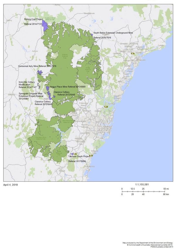
State Party Report on the state of conservation of the Greater Blue Mountains Area (Australia)
Contents
Executive summary ........................................................................................................................................ iv
Résumé ............................................................................................................................................................... vi
1 Introduction .............................................................................................................................................. 9
1.1 Decisions of the World Heritage Committee .................................................................................. 9
1.2 The Greater Blue Mountains Area (GBMA) World Heritage property ................................. 9
1.3 Legislative protection of the GBMA .................................................................................................... 9
1.4 Funding ....................................................................................................................................................... 11
1.5 Quarterly reporting to the World Heritage Centre ................................................................... 12
2 Response from the State Party to the decisions of the World Heritage Committee ..... 13
2.1 Implementation of Decsion 43 COM 7B.2 ..................................................................................... 13
2.2 Proposal to raise the Warragamba Dam wall.............................................................................. 13
2.3 Cumulative assessment of the impacts of mining adjacent to the GBMA ........................ 16
2.4 Mining proposals in the vicinity of the GBMA............................................................................. 17
2.5 Western Sydney Airport (EPBC referral 2014/7391) ............................................................. 20
2.6 Strategic Management Framework ................................................................................................. 21
3 Other current conservation issues identified by the State Party which may have an
impact on the property’s outstanding universal value ........................................................... 23
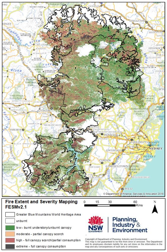
3.1 Impacts of 2019-20 Bushfires ........................................................................................................... 23
3.2 Significant conservation achievements and other changes since World Heritage
listing............................................................................................................................................................ 30
Appendices ...................................................................................................................................................... 34
Appendix 1: Decision 43 COM 7B.2 about the Greater Blue Mountains Area World Heritage
Property adopted by the 43rd session of the World Heritage Committee (Baku, 2019) ........ 34
Appendix 2: Statement of Outstanding Universal Value for the Greater Blue Mountains Area
................................................................................................................................................................................................ 36
References ....................................................................................................................................................... 39
Tables
Table 1 Greater Blue Mountains Area (GBMA) Fire Extent and Severity Mapping (FESM) burnt
area classes ........................................................................................................................................................................ 24
Maps
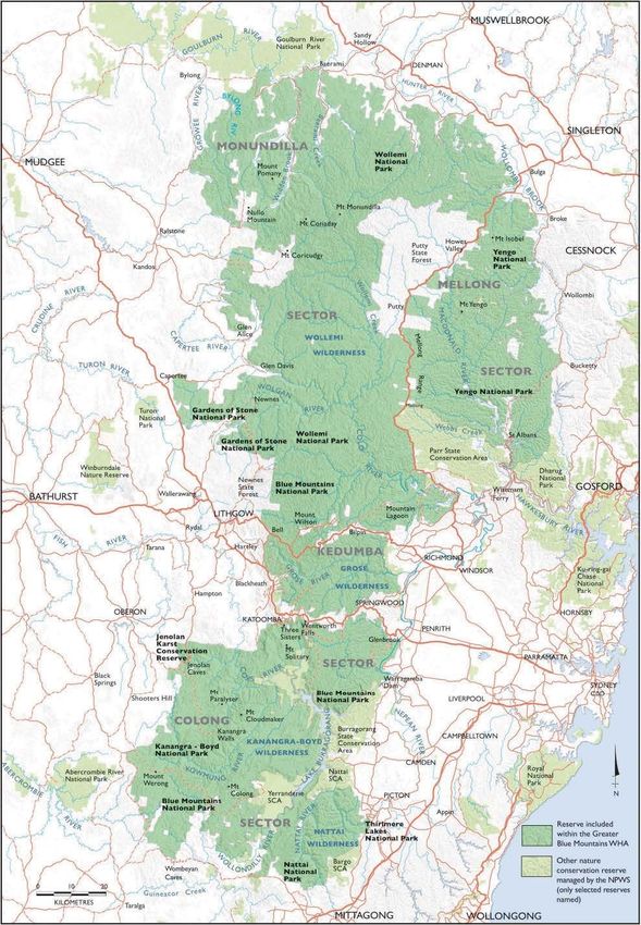
Map 1 Greater Blue Mountains Area (GBMA) World Heritage property and adjacent reserves .. viii
Map 2 GBMA – location of coal mining proposals outside of the World Heritage property
discussed in section 2.4 ................................................................................................................................................ 32
Map 3 GBMA – bushfire affected areas .................................................................................................................. 33
Department of Agriculture, Water and the Environment
iiiState Party Report on the state of conservation of the Greater Blue Mountains Area (Australia)
Executive summary
This report responds to a request from the World Heritage Committee in 2019 (Decision 43 COM
7B.2 at Appendix 1) for a State Party Report on the State of Conservation of the Greater Blue
Mountains Area to be submitted for consideration in 2021.
The Greater Blue Mountains Area (GBMA), located in the state of New South Wales (NSW)
(Map 1), was listed in 2000 on the basis of World Heritage criteria (ix) and (x) for its diversity of
species and habitats and as a centre of diversification for the Australian scleromorphic flora,
particularly the genus Eucalyptus. The World Heritage property, comprised of eight protected
areas, consists of 1.04 million hectares of sandstone plateaux, escarpments and gorges
dominated by temperate eucalypt forest.
The Australian and NSW governments are deeply committed to protecting the Outstanding
Universal Value of the property. There is a strong legislative system in place for the protection
and management of the place. As a World Heritage property, the GBMA is protected as a 'matter
of national environmental significance' under Australia’s national environmental law, the
Environment Protection and Biodiversity Conservation Act 1999 (EPBC Act). The EPBC Act
protects World Heritage properties from the impacts of development activity, even if they
originate outside the property.
A single State government agency, the NSW Department of Planning, Industry and Environment,
manages the area, primarily through the NSW National Parks and Wildlife Service. All the
reserves that comprise the GBMA are also protected under, and subject to, the National Parks
and Wildlife Act 1974 and the Wilderness Act 1987 and other relevant state legislation. The
Greater Blue Mountains World Heritage Area Strategic Plan 2009 provides an over-arching
framework for the property's management, protection, interpretation and monitoring. A new
Strategic Plan is in preparation.
The Australian and NSW Governments are continuing to implement programs and policies for
the protection of the Outstanding Universal Value of the property, including to address the
challenges from a changing climate and the unprecedented bushfire season in 2019-20. In April
2020, the Australian Government provided an update to the World Heritage Centre on the
conservation efforts being undertaken following the 2019-20 bushfires that affected 71 per cent
of the GBMA. The Australian and NSW governments have implemented comprehensive
responses to the bushfires, comprising immediate response and medium to longer-term
recovery action. This is backed by substantial investment in impact assessment, on-ground
recovery action and management planning.
Consistent with Decision 43 COM 7B.2, the Australian Government has commissioned
Commonwealth Scientific and Industrial Research Organisation (CSIRO), Australia’s national
science agency, to conduct an assessment of the potential cumulative impacts of existing and
planned mining projects in the vicinity of the GBMA. This assessment is well advanced. No
mining activity, including exploration, occurs or is permitted within the property.
A detailed Environmental Impact Statement (EIS) is being prepared for the proposal to raise the
Warragamba Dam wall. This assessment is fully assessing all potential impacts on the
Outstanding Universal Value of the property, and its other values including Aboriginal cultural
Department of Agriculture, Water and the Environment
ivState Party Report on the state of conservation of the Greater Blue Mountains Area (Australia)
heritage. This EIS will address statutory requirements under national and State legislation. The
EIS will be submitted to the World Heritage Centre for review by IUCN at the time it is released
for public comment. The EIS process is consistent with IUCN’s World Heritage Advice Note on
Environmental Assessment.
The Warragamba Dam is downstream and outside of the World Heritage property. The proposal
is for flood mitigation downstream of the dam. The Australian Government notified the World
Heritage Centre about this proposal in September 2017 in accordance with Paragraph 172 of the
World Heritage Operational Guidelines.
In response to the challenges posed by global climate change, the Australian Government has
commissioned the CSIRO to undertake an assessment of the vulnerability of Australia’s World
Heritage properties to climate change. This assessment, due to be completed in the first half of
2021, will inform adaption planning for the GBMA.
This report also highlights a number of significant conservation achievements in the GBMA since
it was inscribed on the World Heritage List in 2000.
Department of Agriculture, Water and the Environment
vState Party Report on the state of conservation of the Greater Blue Mountains Area (Australia)
Résumé
Ce rapport répond à une requête du Comité du Patrimoine mondial en 2019 (décision 43 COM
7B.2 à l'annexe 1) pour un rapport de l'État sur l'état de conservation de la région des Grandes
Montagnes Bleues (Greater Blue Mountains) qui sera soumis pour considération en 2021.
La région des Greater Blue Mountains (GBMA), située dans l'État de Nouvelle-Galles du Sud
(NSW) (voir carte 1), a été inscrite en 2000 sur la base des critères du Patrimoine mondial (ix) et
(x) pour sa diversité d'espèces et d'habitats et en tant que centre de diversification de la flore
scléromorphe australienne, en particulier le genre Eucalyptus. Elle fournit une représentation
significative de l'adaptation évolutive et diversification des écosystèmes d'eucalyptus et des
communautés de plantes et d'animaux dans l'isolement post-Gondwana sur le continent
australien. La région du Patrimoine mondial est composé de huit zones protégées qui
comprennent 1,04 million d'hectares de plateaux de grès, d'escarpements et de gorges dominés
par la forêt tempérée composée d'eucalyptus.
Les gouvernements australien et de la Nouvelle-Galles du Sud sont profondément engagés dans
la protection de la valeur universelle exceptionnelle de la GBMA. Il y a un système législatif
solide en place en vertu de la législation des deux gouvernements, pour sa protection et sa
gestion. En tant que faisant partie du Patrimoine mondial, elle est protégée en tant que «
question d'importance environnementale nationale » en vertu de la loi nationale australienne
sur l'environnement, la loi de 1999 sur la protection de l'environnement et la conservation de la
biodiversité (Environment Protection and Biodiversity Conservation Act 1999 - EPBC Act). La loi
EPBC protège les biens du patrimoine mondial des impacts de l'activité de développement,
même s'ils proviennent de l'extérieur de la région.
Une agence unique du gouvernement de l'État, le Ministère de la planification, de l'industrie et
de l'environnement (NSW Department of Planning, Industry and Environment) de la Nouvelle-
Galles du Sud, gère la zone, principalement par l'intermédiaire du service des parcs nationaux et
de la faune de la Nouvelle-Galles du Sud (NSW National Parks and Wildlife Service). Toutes les
réserves qui composent la GBMA sont également protégées et soumises à la loi de 1974 sur les
parcs nationaux et la vie sauvage (National Parks and Wildlife Act 1974) et à la loi de 1987 sur la
vie sauvage (Wilderness Act 1987) et à d'autres législations de l'État pertinentes. Le plan
stratégique 2009 du site du patrimoine mondial des Grandes Montagnes Bleues (Greater Blue
Mountains World Heritage Area Strategic Plan 2009) fournit un cadre global pour la gestion, la
protection, l'interprétation et le suivi du bien. Un nouveau projet de plan stratégique est en
cours de préparation.
Les gouvernements australien et de la Nouvelle-Galles du Sud continuent de mettre en œuvre
des programmes et des politiques pour la protection de la valeur universelle exceptionnelle de la
région bien face à ces défis, notamment en raison du changement climatique et d'une saison
d’incendies de la brousse sans précédent en 2019-20. En avril 2020, le gouvernement australien
a fourni au Centre du Patrimoine mondial une mise à jour sur les efforts de conservation
entrepris à la suite des feux de brousse de 2019-20 qui ont touché 71 % de la GBMA. Les
gouvernements australien et de la Nouvelle-Galles du Sud ont mis en œuvre des réponses
globales aux feux de brousse, comprenant une réponse immédiate et une action de
Department of Agriculture, Water and the Environment
viState Party Report on the state of conservation of the Greater Blue Mountains Area (Australia)
rétablissement à moyen et long terme. Ceci est soutenu par un investissement substantiel dans
l'analyse d'impact, les actions de redressement sur le terrain et la gestion/planification.
Conformément à la décision 43 COM 7B.2, le gouvernement australien a chargé le CSIRO
(Commonwealth Scientific and Industrial Research Organization), l’agence scientifique nationale
australienne, de procéder à une évaluation des impacts cumulatifs potentiels des projets miniers
existants et prévus à proximité de la GBMA. Cette évaluation est bien avancée. Aucune activité
minière, y compris l'exploration, n'a lieu ou n'est autorisée à l'intérieur de la propriété.
Une étude d'impact environnemental (EIE) détaillée est en cours de préparation pour la
proposition de la surélévation de la paroi du barrage de Warragamba. Cette étude évalue
pleinement tous les impacts potentiels sur la valeur universelle exceptionnelle du bien et ses
autres valeurs, y compris le patrimoine culturel autochtone. Cette EIE répondra aux exigences
statutaires de la législation nationale et nationale. Elle sera soumise au Centre du patrimoine
mondial pour examen par l'UICN au moment de sa publication pour commentaires du public. Le
processus d’EIE est conforme à la Note de l’UICN sur l’évaluation environnementale sur le
patrimoine mondial.
Le barrage de Warragamba se trouve en aval et à l'extérieur de la zone du Patrimoine mondial.
La proposition vise à atténuer les inondations qui se produisent en aval du barrage. Le
gouvernement australien avait notifié cette proposition au Centre du Patrimoine mondial en
septembre 2017, et ce conformément au paragraphe 172 des Directives Opérationnelles du
Patrimoine mondial.
En réponse aux défis posés par le changement climatique mondial, le gouvernement australien a
chargé le CSIRO, d'entreprendre une évaluation de la vulnérabilité des biens du patrimoine
mondial australien au changement climatique. Cette évaluation qui sera achevée au cours du
premier semestre 2021, éclairera la planification de l'adaptation pour la GBMA.
Ce rapport met en valeur également un certain nombre de réalisations importantes en matière
de conservation dans la GBMA depuis son inscription sur la liste du Patrimoine mondial en l’an
2000.
Department of Agriculture, Water and the Environment
viiState Party Report on the state of conservation of the Greater Blue Mountains Area (Australia)
Map 1 Greater Blue Mountains Area (GBMA) World Heritage property and adjacent
reserves
Names of constituent reserves are shown in bold text.
Source: Greater Blue Mountains World Heritage Area Strategic Plan 2009
Department of Agriculture, Water and the Environment
viiiState Party Report on the state of conservation of the Greater Blue Mountains Area (Australia)
1 Introduction
1.1 Decisions of the World Heritage Committee
This State Party Report, prepared in cooperation with the Government of New South Wales
(NSW), responds to the 2019 decision of the World Heritage Committee (see Decision
43 COM 7B.2, at Appendix 1).
1.2 The Greater Blue Mountains Area (GBMA) World
Heritage property
The Greater Blue Mountains Area World Heritage property (GBMA) is located in the state of New
South Wales and was inscribed on the World Heritage List in 2000 on the basis of criteria (ix)
and (x). The statement of Outstanding Universal Value is at Appendix 2. The area consists of 1.04
million hectares of sandstone plateaux, escarpments and gorges dominated by temperate
eucalypt forest (see Map 1) and is comprised of eight protected areas (reserves). Key attributes
include:
• outstanding and representative examples in a relatively small area of the evolution and
adaptation of the genus Eucalyptus and eucalypt-dominated vegetation on the Australian
continent. The Wollemi pine (Wollemia nobilis) and Blue Mountains pine (Pherosphaera
fitzgeraldii) are outstanding examples of ancient, relict species with Gondwanan affinities
(criterion ix).
• outstanding diversity of habitats and plant communities that support its globally significant
species and ecosystem diversity. A significant proportion of the Australian continent’s
biodiversity occur in the area (criterion x) including mammals, reptiles, frogs and birds.
The GBMA is noted for its representation of the evolutionary adaptation and diversification of
eucalypt ecosystems and communities of plants and animals in post-Gondwana isolation on the
Australian continent. It provides significant representation of biodiversity with ten percent of
Australia's vascular flora, including ninety-seven eucalypt taxa, as well as significant numbers of
rare or threatened species, including endemic and evolutionary relict species such as the
Wollemi pine, which have persisted in highly-restricted microsites. It is also outstanding for its
exceptional expression of the structural and ecological diversity of the eucalypts associated with
its wide range of habitats.
1.3 Legislative protection of the GBMA
Australia’s national environmental law, the Environment Protection and Biodiversity
Conservation Act 1999 (EPBC Act) provides an overarching high level of protection for the
Outstanding Universal Value of the GBMA. It does this by regulating actions occurring within or
outside a property that have, will have or are likely to have a significant impact on the
Outstanding Universal Value of a World Heritage property. Under the EPBC Act, World Heritage
values (Outstanding Universal Value) are one of the protected 'matters of national
environmental significance' and as such they trigger application of the Act.
Department of Agriculture, Water and the Environment
9State Party Report on the state of conservation of the Greater Blue Mountains Area (Australia)
There are two key stages in the environment assessment process required by the EPBC Act.
Stage 1: Referral – this stage determines whether or not a proposed action requires approval
under the EPBC Act. Where a development proposal (proposed action) has, will have or is likely
to have a significant impact on Outstanding Universal Value, it is determined to be a ‘controlled
action’ and must undergo assessment and a decision whether or not to approve the action.
Stage 2: Assessment/decision whether to approve – Proposed actions can be assessed using a
hierarchy of assessment methods. Assessments can also be undertaken by State governments
for the purposes of both decisions under the EPBC Act, as well as decisions that may be required
under NSW regulatory requirements. All assessment processes include transparent measures
for public consultation. A list of referrals made under the EPBC Act, including those for projects
outside, but in the vicinity of the GBMA, can be accessed on the Department of Agriculture,
Water and the Environment's EPBC Act – Public Notices web page.
Under Australia’s federal system of government, management of the GBMA is the responsibility
of the NSW State Government. This management is guided by the Greater Blue Mountains World
Heritage Area Strategic Plan 2009 (NSW NPWS 2009). Its purpose is to bring strategic coherence
to the overall management of the property, which, as noted above, comprises eight separate
protected areas. Under the EPBC Act (s321-322), the Australian Government must use best
endeavours to work with the state government to prepare a management plan that is not
inconsistent with Australia's obligations under the World Heritage Convention and the
Australian World Heritage Management Principles (Schedule 5, Environment Protection and
Biodiversity Conservation Regulations 2000). The Australian Government must then take all
reasonable steps to act in a way that is not inconsistent with that plan. The current management
plan is the Greater Blue Mountains World Heritage Area Strategic Plan 2009 (NSW NPWS 2009).
A new draft plan is in preparation.
There is a range of NSW state legislation that governs the management of the GBMA. This
includes the National Parks and Wildlife Act 1974, the Wilderness Act 1987, the Water NSW Act
2014, the Biodiversity Conservation Act 2016, and the Environmental Planning and Assessment Act
1979.
The GBMA reserves are subject to the NSW National Parks and Wildlife Act 1974 and the NSW
Wilderness Act 1987. These Acts cover the protection and management of areas such as national
parks, nature reserves and wilderness (some 66% of the GBMA in parts of the Blue Mountains,
Kanangra-Boyd, Nattai, Wollemi and Yengo National Parks is declared wilderness). The National
Parks and Wildlife Act 1974 requires that a plan of management is prepared for each the reserves
of the GBMA. The National Parks and Wildlife Act 1974 is also the main piece of legislation for
managing and protecting Aboriginal cultural heritage in NSW. This Act provides for the
management of Aboriginal land, Aboriginal Places and Aboriginal objects. Emu Cave, Euroka
Clearing “Nye Gnoring”, Kings Tableland, Red Hands Cave and Mount Yengo Aboriginal Places
and Finchley Aboriginal Area are gazetted under the National Parks and Wildlife Act 1974 within
the boundary of the property.
The NSW Biodiversity Conservation Act 2016 provides for managing and protecting biodiversity
and threatened species in NSW. It provides for statutory listing and protection for every
threatened animal, plant, invertebrate and ecological community.
Department of Agriculture, Water and the Environment
10State Party Report on the state of conservation of the Greater Blue Mountains Area (Australia)
The NSW Environmental Planning and Assessment Act 1979 (NSW EP&A Act) and Environmental
Planning Instruments specify what kinds of development are allowed in an area and whether
development consent is required. For example, the Warragamba Dam Raising proposal is
defined as State Significant Infrastructure under the NSW EP&A Act and is subject to concurrent
assessment and approval under that Act and the EPBC Act.
Natural, cultural and built heritage is also protected in NSW under the Heritage Act 1977. A
complex of 37 Blue Mountains Walking tracks in the GBMA are included on the NSW State
Heritage Register. In addition to state level heritage, 33 heritage matters across the GMBA are
included in relevant Local Environment Plans under the NSW Environmental Planning and
Assessment Act 1979.
The GBMA protects a large number of pristine and relatively undisturbed water catchment
areas, some of which make a substantial contribution to maintaining high water quality in a
series of water storage reservoirs supplying Sydney and adjacent rural areas. The population of
Greater Sydney was approximately 5.3 million in June 2019 (ABS 2020). The function of the NSW
Water NSW Act 2014 is to manage and protect these declared catchment areas.
1.4 Funding
The NSW Government is responsible for the on-ground management of the GBMA. It provides an
estimated budget of over AUD$10 million per year for infrastructure maintenance, visitor
management, pest and weed control, access management and maintenance, survey and
monitoring, fire management and biodiversity and threatened species management. Additional
NSW Government funding is allocated for one off capital projects for infrastructure
improvements, additional grant funding for pest and weed control, threatened species
management, and fire suppression.
Additional NSW funding includes the 'Improving access to National Parks' program, to enhance
safe access to National Parks for both visitors and staff, of which over AUD$34 million has been
allocated to the World Heritage property and adjacent region.
Under the Australian Government’s Regional Land Partnerships Program, regional and local
organisations in the Blue Mountains region have received funding for projects that support the
conservation of the GBMA by managing pressures in areas surrounding the property.
• Greater Sydney Local Land Services is delivering a five year project (2018-2023) ‘Protecting
the values of the Greater Blue Mountains World Heritage Area through management of pest
species’, valued at about AUD$1.9 million.
• NSW Local Lands Services (Central Tablelands) is managing a similar and complementary
five-year project (2018-2023), 'Living on the edge – managing invasive species threats to
the Greater Blue Mountains World Heritage Area', one of five projects for this organisation
together awarded approximately AUD$8.2 million.
• Local Land Services – South East recently completed a 2-year project (2018-2020)
'Protecting the Greater Blue Mountains World Heritage Area', one of ten projects for this
organisation together awarded approximately AUD$7.5 million.
The Australian Government provides AUD$185,000 each year to jointly fund with the NSW
Government an Executive Officer and a Joint Management Coordinator for the property, and to
Department of Agriculture, Water and the Environment
11State Party Report on the state of conservation of the Greater Blue Mountains Area (Australia)
support the operation of the Greater Blue Mountains advisory committee. The Executive Officer
is the secretariat to the Greater Blue Mountains advisory committee and organises their
meetings. The Executive Officer also coordinates reporting and information flow between the
NSW and Australian Governments on matters relating to the World Heritage property. The Joint
Management Coordinator provides secretariat support to a number of Traditional Owner
committees and their associated projects in and around the World Heritage property, as well as
other engagement activities with Traditional Owners. The Joint Management Coordinator is an
Indigenous person. The Greater Blue Mountains Advisory Committee is comprised of people
representing the various Indigenous Traditional Owner groups, a range of scientific and heritage
specialists, and tourism and local (municipal) government representatives.
The Australian Government also provides one-off grants for specific purposes. Recently, such
projects have included:
• A monitoring system for conservation of swamps in the Blue Mountains (AUD$142,000 to
the Blue Mountains World Heritage Institute Limited – DAWE 2020a)
• Improving interpretation materials across the Blue Mountains – aimed at improving
educational and interpretive signage for visitors and education groups (AUD$600,000 from
the Australian Government, AUD$300,000 from the NSW Government (DAWE 2020b)).
1.5 Quarterly reporting to the World Heritage Centre
The Australian Government routinely informs the World Heritage Centre of potential
development activities that may affect the Outstanding Universal Value of Australia’s World
Heritage properties.
Notification reports and a full list of proposed, approved and withdrawn actions relating to the
GBMA (and other areas) that require consideration under the EPBC Act are available at the
Department's World Heritage Committee notification of development proposals website.
The most recent proposed development included in the notification reports for the GBMA was
the Warragamba Dam raising project, reported in September 2017.
Department of Agriculture, Water and the Environment
12State Party Report on the state of conservation of the Greater Blue Mountains Area (Australia)
2 Response from the State Party to
the decisions of the World Heritage
Committee
2.1 Implementation of Decision 43 COM 7B.2
The full text of the 2019 World Heritage Committee decision is provided at Appendix 1. Relevant
paragraphs from the decision are quoted below, and a State Party response is provided for each.
2.2 Proposal to raise the Warragamba Dam wall
Decision 43 COM 7B.2 Paragraph 3:
Notes with concern that the State Party recognises that the proposed raising of the Warragamba Dam wall is
expected to increase the frequency and extent of temporary inundation of the property upstream of the dam
Decision 43 COM 7B.2 Paragraph 4:
Considers that the inundation of areas within the property resulting from the raising of the dam wall are
likely to have an impact on the Outstanding Universal Value (OUV) of the property… recalls Decision
40 COM 7, in which it considered that the construction of dams with large reservoirs within the boundaries
of World Heritage properties is incompatible with their World Heritage status… requests the State Party to
ensure… that the current process to prepare an Environmental Impact Statement (EIS) for the proposal fully
assesses all potential impacts on the OUV of the property and its other values including Aboriginal cultural
heritage and to submit a copy of the EIS to the World Heritage Centre for review by IUCN, prior to taking any
final decisions regarding the project.
State Party's response
2.2.1 Overview of the proposal
Warragamba Dam is located west of Sydney in NSW (see Map 1). Its reservoir, Lake
Burragorang, is formed by the damming of the Warragamba River with its major tributaries
being the Coxs, Wollondilly, Kowmung and Nattai rivers. Lake Burragorang supplies water to
more than five million people living in Sydney and the lower Blue Mountains. It is one of the
largest domestic water supply dams in the world and stores around 80 per cent of Sydney's
water supply. Warragamba Dam and Lake Burragorang are located outside of the GBMA.
Warragamba Dam is owned and operated by WaterNSW (a NSW Government owned
corporation) under the provisions of the Water NSW Act 2014.
The proposal to raise Warragamba Dam for flood mitigation is one of nine key outcomes of the
NSW Government’s flood risk management strategy for the Hawkesbury-Nepean Valley
(Infrastructure NSW 2017). The purpose of the proposed dam raising is to reduce and/or delay
flooding downstream, significantly reducing risk to lives and property, and allowing additional
time for evacuation during major floods. It would only operate during flood conditions.
Department of Agriculture, Water and the Environment
13State Party Report on the state of conservation of the Greater Blue Mountains Area (Australia)
2.2.2 Statutory assessment processes
The Warragamba Dam wall raising proposal is being assessed under the NSW Environmental
Planning and Assessments Act 1979 and the EPBC Act. The proposal is being assessed for its
potential impacts on World Heritage and National Heritage listed values and nationally listed
threatened species. For the purposes of the EPBC Act, the proposal is being assessed by the NSW
Government on behalf of the Australian Government under an assessment bilateral agreement
(see section 1.3). The final decision on whether the proposal should be approved under the
EPBC Act will be made by the Australian Minister for the Environment. A separate decision on
whether the proposal should be approved is also required under NSW environmental protection
legislation.
The Australian Government notified the World Heritage Centre about this proposal in
September 2017 in accordance with Paragraph 172 of the World Heritage Operational
Guidelines.
A detailed Environmental Impact Statement (EIS) is being prepared by WaterNSW, the NSW
Government-owned statutory corporation that owns and operates the dam. Once finalised the
EIS will be scheduled for exhibition and public comment for a minimum period of 30 days. In
accordance with Decision 43 COM 7B.2, a copy of the EIS will be provided to the World Heritage
Centre for review by the International Union for the Conservation of Nature (IUCN) in
conjunction with its public exhibition. No construction activity on the dam wall can occur unless
and until all relevant Australian and NSW government approvals are in place. Subject to
environmental and planning approvals being granted, the NSW Government will consider the
business case for the dam wall raising.
The NSW Government's responses to frequently asked questions about raising the dam wall are
on Infrastructure NSW's Proposal to raise Warragamba Dam Wall FAQs website.
On 28 June 2020, the NSW Government proposal to raise the dam wall was varied to raise the
Warragamba Dam wall by 17 metres, an additional 3 metres from the original proposal of
14 metres, for flood mitigation purposes downstream of the dam. The proposed increase to the
height of the spillway will remain at 12 metres, as per the original proposal. The purpose of this
variation is to enable the spillway crest height to be raised in the future (subject to further
environmental impact assessment and approval) in response to changes in rainfall patterns
caused by climate change in accordance with NSW Government statutory requirement that
climate change impacts are taken into account in infrastructure planning. As the height of the
spillway crest (12 metres) and therefore the full supply level of the dam remains unchanged
from the original proposal, the varied action will not result in any further impacts on World and
National Heritage values of the GBMA or listed threatened species and communities beyond
those related to the original proposal.
2.2.3 Potential impacts of the proposal
Areas of the GBMA upstream of Warragamba Dam are already prone to inundation during
floods, especially if the dam is full or near to full. Raising the dam wall would increase the
frequency, duration, depth and/or extent of temporary inundation of areas located upstream of
the dam wall, including declared wilderness area, under some flood conditions.
Department of Agriculture, Water and the Environment
14State Party Report on the state of conservation of the Greater Blue Mountains Area (Australia)
Raising the dam wall will not change the permanent water storage level in the dam, but
temporary inundation associated with the proposed dam raising may have impacts on
biodiversity (including a number of threatened species), aesthetic, wilderness and Indigenous
cultural values.
The Australian Government requires that potential impacts of the dam raising project relevant
to the property are fully addressed in the Environmental Impact Statement (EIS).
Aboriginal cultural heritage values have been identified within the World Heritage Area. A full
Aboriginal Cultural Heritage Assessment report regarding the impact of the proposal on
Aboriginal culture heritage values found in the property will be appended to the publicly-
released EIS. In August 2018, an Aboriginal Place nomination was made by Traditional Owners
for an extensive area in the Burragorang Valley in the GBMA. When a signifigant place is
declared an Aboriginal Place, it is protected under the NSW National Parks and Wildlife Act 1974.
Aboriginal Places can be on public or private land, and do not change the land tenure. To be
declared an Aboriginal Place, the NSW Minister is required to legally recognise the place is, or
was of special significance to Aboriginal culture.
On 20 June 2019 a NSW Parliamentary Inquiry was established to inquire into the proposal to
raise the Warragamba Dam wall (Parliament of NSW 2019). Topics for the Inquiry include:
engagement between relevant organisations, flood risk assessment and management and the
cost of the project. The Inquiry is ongoing, with the most recent hearing occurring on 6
November 2020. No final reporting date has been advised at this stage. Further detail is available
on the Parliament of NSW's Select Committee on the Proposal to Raise the Warragamba Dam
Wall website.
2.2.4 Preparation of the Environmental Impact Statement (EIS)
WaterNSW is preparing the EIS for the proposal following a detailed set of requirements
established by the NSW and Australian governments (DPIE 2015). The terms of reference for the
EIS require ‘an analysis of any feasible alternatives to the project’.
Since mid-2017, WaterNSW has undertaken research and investigations to inform the EIS. The
EIS will include an assessment of impacts of the temporary increase in inundation on the
upstream and downstream environment – and options to manage, mitigate or offset those
impacts. The Australian Government has requested that WaterNSW undertake an analysis of the
impacts of the 2019-20 bushfires given that approximately 70 per cent of the predicted
temporary inundation area resulting from the proposal was burnt in the bushfires.
Following the formal public comment period, the EIS will be assessed by the NSW Government.
After this assessment is completed, the Australian Government will consider all relevant
information including impacts of the bushfires on the World Heritage values of the GBMA and
listed threatened species and ecological communities. The Australian Government Minister for
the Environment will then make a decision on whether to approve the proposed action.
A draft EIS has recently been provided to the NSW Government planning department and
Australian Government for review against the requirements of both NSW and Australian
Government legislation. Work is underway by WaterNSW to respond to matters raised by
government agencies as part of that review and ahead of finalising the EIS for public exhibition.
Department of Agriculture, Water and the Environment
15State Party Report on the state of conservation of the Greater Blue Mountains Area (Australia)
These matters largely relate to the biodiversity assessment, the Aboriginal Cultural Heritage
assessment, and the impacts of the 2019-20 bushfires.
2.3 Cumulative assessment of the impacts of mining
adjacent to the GBMA
Decision 43 COM 7B.2 Paragraph 5:
… requests the State Party to undertake an assessment of potential cumulative impacts of all existing and
planned mining projects in the vicinity of the property through a Strategic Environmental Assessment (SEA)
or a similar mechanism.
State Party's response
In response to the decision of the World Heritage Committee, the Australian government
commissioned CSIRO, Australia’s national science agency, to undertake a cumulative impact
assessment of risks from existing and planned mining in the vicinity of the GBMA to its
Outstanding Universal Value. CSIRO is due to report to the Australian Government by the end of
2020. It is important to note that mining activity does not occur, and is prohibited, within the
boundary of the GBMA.
To assess potential cumulative impacts of all existing and planned mining projects in the vicinity
of the GBMA, the assessment will identify: the components of the GBMA that contribute to its
Outstanding Universal Value, existing and planned mining operations in the vicinity of the GBMA
that could affect its Outstanding Universal Value, specific threats from mining to the property’s
Outstanding Universal Value, and the mechanisms in place to protect the Outstanding Universal
Value of the GBMA.
The scope of the assessment includes fifteen existing and planned open-cut and underground
coal mines and three sand mines within 20 km of the GBMA. CSIRO has developed a causal
pathway network model that captures all the ways that potentially hazardous actions, or
stressors from mine sites (e.g groundwater pumping associated with underground mining)
could affect the Outstanding Universal Value of the GBMA. Each stressor pathway linking mining
projects and Outstanding Universal Value will be rated in terms of the magnitude and likelihood
of adverse effects from mining.
The assessment will identify and analyse stressors that present a risk to Outstanding Universal
Value and also identify the geographic areas within the GBMA where effects from mining could
be significant, if those effects were to arise. Habitats, ecological communities and species in
these areas will not necessarily be impacted by mining, rather the assessment will identify a
regional risk where consideration of more detailed local-scale information is needed to
determine whether there is a risk to individual components of the Outstanding Universal Value.
Department of Agriculture, Water and the Environment
16State Party Report on the state of conservation of the Greater Blue Mountains Area (Australia)
2.4 Mining proposals in the vicinity of the GBMA
Decision 43 COM 7B.2 Paragraph 6:
Reiterates its position that mineral exploration or exploitation is incompatible with World Heritage status,
which is supported by the International Council of Mining and Metals (ICMM) Position Statement to not
undertake such activities within World Heritage properties.
State Party's response
2.4.1 Summary
The GBMA is protected and managed under both national and state legislation. Mining is
prohibited in the GBMA under this legislation.
As noted in section 1.3, all World Heritage properties in Australia are ‘matters of national
environmental significance’ protected and managed under the EPBC Act. This Act is the statutory
instrument for implementing Australia’s obligations under a number of multilateral
environmental agreements including the World Heritage Convention. By law, any action that
has, will have or is likely to have a significant impact on the World Heritage values of a World
Heritage property must be referred to the responsible Minister for consideration. Substantial
penalties apply for taking such an action without approval. Once a heritage place is listed, the Act
provides for the preparation of management plans which set out the significant heritage aspects
of the place and how the values of the site will be managed.
Importantly, this Act also protects matters of national environmental significance, including
World Heritage properties, from impacts even if they originate outside the property or if the
values of the property are mobile (as in fauna). It thus forms an additional buffer of protection
for the values of World Heritage properties from external impacts.
Additionally, the EPBC Act provides that the Minister must not approve actions or classes of
actions that are inconsistent with Australia's obligations under the World Heritage Convention
(sections 34B, 37D, 51, 137, and 146G). This effectively prohibits mining in World Heritage
properties in Australia.
Eight mining proposals lie outside the GBMA boundary, but in the vicinity of the property,
ranging from directly adjacent to the property to over eight kilometres away from the boundary.
These eight projects have been, or are currently being assessed, under the EPBC Act, with
specific focus on impacts to heritage values.
2.4.2 Background and summary of mining proposals
Coal mining has played a major role in the economy of the region since the 1870s. The major
coal resources in NSW are located in the 500 kilometre long, 150 kilometre wide Sydney-
Gunnedah Basin. An important factor in the economic development of NSW has been the ease of
access to coal as an energy resource for the State's main industrial centres. NSW is one of the
world's major exporters of coal.
The continued development of coal resources takes into account competing land uses and a
range of environmental issues. Mining is prohibited in national parks under NSW legislation and
there is no mining within the GBMA. A number of mines near the GBMA were in existence at the
Department of Agriculture, Water and the Environment
17State Party Report on the state of conservation of the Greater Blue Mountains Area (Australia)
time it was nominated for inclusion in the World Heritage List and are still in operation. The
following is a summary of mining developments or mining proposals, that have been, or are
being, assessed under the EPBC Act and which are in the area adjacent to the GBMA.
2.4.3 Airly Mine Extension Project (EPBC referral 2013/7076)
The Airly Mine Extension Project is adjacent to the northern sector of the Gardens of Stone
National Park and is outside of the World Heritage Area (see Map 2). The project involves
mining to extend the life of the existing Airly Mine, with additional surface facilities and
infrastructure to support the extension. The project was referred under the EPBC Act in
December 2013. The environmental assessment identified water discharge to the GBMA as the
primary risk posed by the proposed development. The project was approved in May 2017, with
strict conditions requiring implementation of a site water management system to manage the
risk to Outstanding Universal Value. A statement of reasons for this decision was made available
to the public on 20 March 2019.
2.4.4 Angus Place Mine Extension Project (EPBC referral 2013/6889)
The Angus Place Extension Project involves underground mining at the existing Angus Place
Mine in the Western Coalfields of NSW, outside of the World Heritage Area (see Map 2). The
Gardens of Stone National Park is located adjacent to the north eastern edge of the mine. In
November 2019, the Australian Government varied the project at the request of the proponent.
The variation reduced the area of land to be impacted by 17 per cent. The varied project is
undergoing assessment under the EPBC Act.
2.4.5 Bylong Coal Project – reconsideration of previous decision (EPBC
referral 2014/7133)
The open cut and underground mining components of the Bylong Coal Project are about two and
four kilometres respectively distant from the World Heritage property. The project was assessed
under the EPBC Act for potential impacts on the Outstanding Universal Value of the property in
2014. It was determined that the proposal was unlikely to have a significant impact on
Outstanding Universal Value and therefore further environmental impact assessment in relation
to Outstanding Universal Value was not required by the Australian Government.
In response to a recent request by the Lock the Gate Alliance (a non-governmental organisation),
and on the basis of new information that could be relevant to that decision, the Australian
Government Minister for the Environment reconsidered this decision on 21 March 2019, as
provided under the EPBC Act. Following detailed consideration of new information, the previous
decision of 12 March 2014 was confirmed. The review decision reaffirmed that there would be
no significant impact on Outstanding Universal Value of the GBMA. On 18 September 2019, the
NSW Independent Planning Commission refused development consent for the project. The
project is now the subject of an appeal by the proponent to the NSW Land and Environment
Court.
2.4.6 Clarence Colliery (EPBC referral 2012/6446)
The Clarence Colliery is an underground coal mine located in Newnes State Forest. The mine site
is adjacent to the World Heritage property (see Map 2).
Clarence Colliery has been in operation since before the commencement of the EPBC Act. In July
2015, a substantial coal fines stockpile collapsed into the Wollangambe River, resulting in
Department of Agriculture, Water and the Environment
18State Party Report on the state of conservation of the Greater Blue Mountains Area (Australia)
pollution of the river within the GBMA. The mining company was prosecuted under New South
Wales law and directed to pay over a million dollars for environmental management, planning
and fauna conservation projects in the region. This was in addition to more than 12 months’
work by the company at a cost to it of AUD$2 million to clean up the impacts of the incident
(NSW EPA 2017).
The Australian Government also investigated the incident and undertook field inspections with
two independent scientific consultancy reports produced. Based on this investigation the
Australian Government is satisfied with the remediation works and has concluded that there
have been no long-term impacts on the Outstanding Universal Value of the GBMA.
2.4.7 Coalpac Pty Invincible Colliery Modification (EPBC referral
2014/7147)
The Invincible Colliery is an open cut and longwall coal mine located mostly within Ben Bullen
State Forest. The Invincible Colliery Southern Extension is also within Ben Bullen State Forest
(see Map 2). The proposed mining operation is more than eight kilometres from the GBMA at
the closest point. It is separated from the GBMA to the east by eucalypt forest, cleared farmland,
Coxs River and several other streams. It has been assessed under the EPBC Act as unlikely to
have a significant impact on the Outstanding Universal Value of the GBMA.
2.4.8 South Bates Extension (EPBC referral 2016/7816)
The Wambo Mine South Bates Extension project boundary adjoins the Wollemi National Park
(see Map 2). Potential subsidence impacts (including the angle of draw) from some of the
underground longwall panels may occur up to the boundary of Wollemi National Park.
The project’s surface disturbance comprises two new ventilation shafts that are approximately
1.6 kilometres to 2 kilometres away from Wollemi National Park. Given the depth of the
underground extraction area in relation to the GBMA, it was determined that mining activity
would not adversely impact the Wollemi escarpment or rock features within the neighbouring
Wollemi National Park. Additionally, as the project is not located in the GBMA it was determined
that it would not significantly impact the area’s biodiversity values which form part of the
Outstanding Universal Value of the property. This project has been assessed and approved with
conditions under the EPBC Act for its potential impact on threatened species and communities,
and water resources. It was determined that it was unlikely that there would be a significant
impact on the Outstanding Universal Value of the GBMA.
2.4.9 Springvale Mine Extension (EPBC referral 2013/6881)
Springvale Coal Mine is an underground longwall mine. It is located 6.5 kilometres west of Blue
Mountains National Park (see Map 2). Subsidence associated with the longwall mining has
impacted on groundwater and surface water, reducing flows into some streams that run into the
GBMA.
Under the EPBC Act the decision concluded that the proposed action is unlikely to have a
significant impact on the GBMA, and therefore the impacts of the proposed action would not be
unacceptable. The proposal was approved with conditions which are set out in a statement of
reasons published on 1 March 2016.
The NSW Government oversees control of water quality in Coxs River, which flows into Lake
Burragorang, the main water supply dam for the city of Sydney. While levels of salt, heavy metals
Department of Agriculture, Water and the Environment
19State Party Report on the state of conservation of the Greater Blue Mountains Area (Australia)
and other contaminants are above natural background levels, these are not considered to impact
on the Outstanding Universal Value of the property. The NSW Government put in place
conditions related to water management operations.
2.4.10 Tahmoor South Project (EPBC referrals 2014/7162 and 2017/8084)
The Tahmoor Colliery is more than 2.5 kilometres from the World Heritage property (see Map
2). Long-wall underground coal mining in the part of the Tahmoor Colliery closest to Thirlmere
Lakes, ceased eight years ago. The relationship between the coal mining operation and the water
levels in Thirlmere Lakes has been the subject of close scrutiny and investigation over recent
years, including through a NSW Government sponsored independent public inquiry and ongoing
research. The NSW Government is currently studying water loss from the lakes, including
whether any long-term damage has occurred from mining. The Australian Government has
provided funds for water level monitoring data analysis (NSW OEH 2019).
Modelling work conducted as part of a recent EIS on a proposed southward extension to the
Tahmoor Colliery, away from the World Heritage property, indicates that if the proposal
proceeds, the water levels of Thirlmere Lakes could be expected to decrease by about one to six
centimetres, with an increase in the predicted average number of weeks per decade that the
lakes would be without discernible ponded water increasing by between 3 weeks and 5.2 weeks.
This proposal is still being assessed under the EPBC Act for its potential impact on threatened
species and ecological communities, and water resources (it was considered that it was unlikely
that there would be a significant impact on the Outstanding Universal Value of the property).
2.5 Western Sydney Airport (EPBC referral 2014/7391)
Decision 43 COM 7B.2 Paragraph 7:
Notes the information provided by the State Party regarding the Western Sydney Airport proposal and
further requests the State Party to submit to the World Heritage Centre a copy of the EIS for the anticipated
airspace and flight path operations, once available, for review by IUCN.
State Party's response
In December 2016 the Australian Government approved the construction of the Western Sydney
Airport subsequent to the publication and finalisation of an Environmental Impact Statement
and the production of an Airport Plan. The Western Sydney Airport will be located eight
kilometres east of the GBMA.
The Airport Plan approval conditions specify that the airport and flight path design must
minimise, to the extent practicable, the impact of aircraft over-flight noise on the GBMA,
particularly areas of scenic or tourism value, and wilderness areas (DITRDC 2016). The
assessment documentation explains how the conditions of the Airport Plan have been
addressed.
The airspace and flight path design is currently being developed by an expert Steering Group, led
by the Australian Government. Once developed, the airspace and flight path design will be t
subject to assessment and authorisation under relevant Australian Government legislation,
including development of environmental assessment documentation and a public comment
Department of Agriculture, Water and the Environment
20You can also read