Tollingo Nature Reserve and Woggoon Nature Reserve - NSW NATIONAL PARKS & WILDLIFE SERVICE
←
→
Page content transcription
If your browser does not render page correctly, please read the page content below
NSW NATIONAL PARKS & WILDLIFE SERVICE

Tollingo Nature Reserve and
Woggoon Nature Reserve
Draft Planning Considerations

environment.nsw.gov.au
© 2020 State of NSW and Department of Planning, Industry and Environment
With the exception of photographs, the State of NSW and Department of Planning, Industry
and Environment are pleased to allow this material to be reproduced in whole or in part for
educational and non-commercial use, provided the meaning is unchanged and its source,
publisher and authorship are acknowledged. Specific permission is required for the
reproduction of photographs.
The Department of Planning, Industry and Environment (DPIE) has compiled this report in
good faith, exercising all due care and attention. No representation is made about the
accuracy, completeness or suitability of the information in this publication for any particular
purpose. DPIE shall not be liable for any damage which may occur to any person or
organisation taking action or not on the basis of this publication. Readers should seek
appropriate advice when applying the information to their specific needs.
All content in this publication is owned by DPIE and is protected by Crown Copyright, unless
credited otherwise. It is licensed under the Creative Commons Attribution 4.0 International
(CC BY 4.0), subject to the exemptions contained in the licence. The legal code for the
licence is available at Creative Commons.
DPIE asserts the right to be attributed as author of the original material in the following
manner: © State of New South Wales and Department of Planning, Industry and
Environment 2020.
Cover photo: Mallee shrubland in Woggoon Nature Reserve. Photo: Claire Davis/DPIE.
This document is a draft for public comment. The provisions in the final document may differ
from the provisions of this draft document.

Published by:
Environment, Energy and Science
Department of Planning, Industry and Environment
Locked Bag 5022, Parramatta NSW 2124
Phone: +61 2 9995 5000 (switchboard)
Phone: 1300 361 967 (Environment, Energy and Science enquiries)
TTY users: phone 133 677, then ask for 1300 361 967
Speak and listen users: phone 1300 555 727, then ask for 1300 361 967
Email: info@environment.nsw.gov.au
Website: www.environment.nsw.gov.au
Report pollution and environmental incidents
Environment Line: 131 555 (NSW only) or info@environment.nsw.gov.au
See also www.environment.nsw.gov.au
ISBN 978-1-922431-26-4
EES 2020/0237
June 2020

Find out more about your environment at:

www.environment.nsw.gov.au
Contents
How to use this document                                            v
     Acknowledgments                                                v
     Contact us                                                     v
1.   Tollingo Nature Reserve and Woggoon Nature Reserve             1
2.   Protecting the natural environment                            3
     2.1   Geology and landform                                     3
     2.2   Native plants                                            3
     2.3   Native animals                                           6
     2.4   Weeds and pest animals                                  10
     2.5   Fire management                                         13
     2.6   Climate change                                          15
3.   Looking after our culture and heritage                        18
     3.1 Aboriginal culture and heritage                           18
     3.2 Shared heritage                                           19
4.   Providing for visitor use and enjoyment                       22
5.   NPWS infrastructure and services                              24
6. Non-NPWS infrastructure and services                            25
Appendices                                                         26
     Appendix A   Legislation and policy                           26
     Appendix B   Scientific plant and animal names                27
     Appendix C   Vegetation classes and communities in the park   30
     Appendix D   Pests and weeds in the park                      31
Abbreviations                                                      32
References                                                         33

                                           iii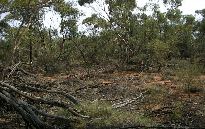
List of tables
Table 1   Regionally significant plants in the reserves............................................... 5
Table 2   Threatened animals in the reserves ........................................................... 8

List of figures
Figure 1 Map of Tollingo Nature Reserve                                                                vi
Figure 2 Map of Woggoon Nature Reserve                                                                 vii
Figure 3 Air photo image showing the reserves in a mosaic of agricultural land
         (2016)                                                                                         2

                                                  iv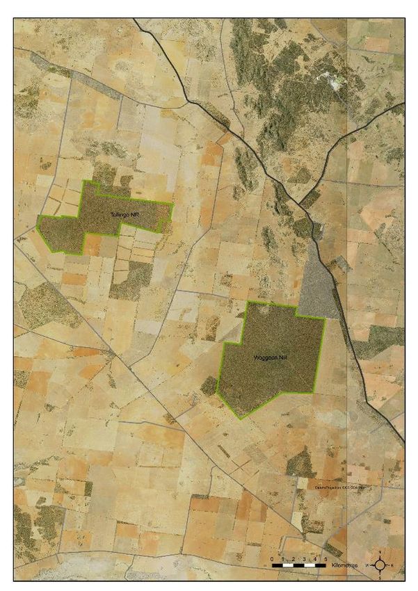
Tollingo Nature Reserve and Woggoon Nature Reserve Draft Planning Considerations

How to use this document
This planning considerations document outlines the matters considered in preparing the
Tollingo Nature Reserve and Woggoon Nature Reserve Plan of Management, including the
reserves’ key values, management principles and management considerations. Further
information, including scientific names for common names of species, is provided in the
appendices.
It is recommended that readers of this document also read the plan of management.
The plan of management describes the desired outcomes for the reserves’ values and
actions that National Parks and Wildlife Service (NPWS) proposes to undertake to achieve
these outcomes. It also sets out the recreational and commercial activities that are permitted
in the reserves and any requirements to undertake these activities, including whether
consent must be sought from the National Parks and Wildlife Service to undertake them.
This planning considerations document will be updated when appropriate, for example, if we
have new information on:
•   the values of the reserves (e.g. new threatened species)
•   management approaches (e.g. new pest management techniques)
•   new programs.
Changes will only be made to this document if they are consistent with the plan of
management.

Acknowledgments
Tollingo Nature Reserve is in the traditional Country of the Ngiyampaa People and the
Wiradjuri People. Woggoon Nature Reserve is in the traditional Country of the Wiradjuri
People.
This planning considerations document was prepared by staff of NPWS.

Contact us
For more information about this document or Tollingo and Woggoon nature reserves, contact
the NPWS Central West Area at Government Office Building, Camp Street, Forbes; PO Box
774, Forbes NSW 2871; or by telephone (02) 6850 2400.

                                                  v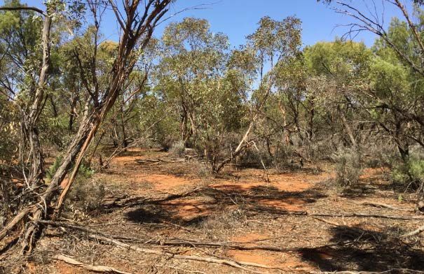
Tollingo Nature Reserve and Woggoon Nature Reserve Draft Planning Considerations

Figure 1   Map of Tollingo Nature Reserve

                                                  vi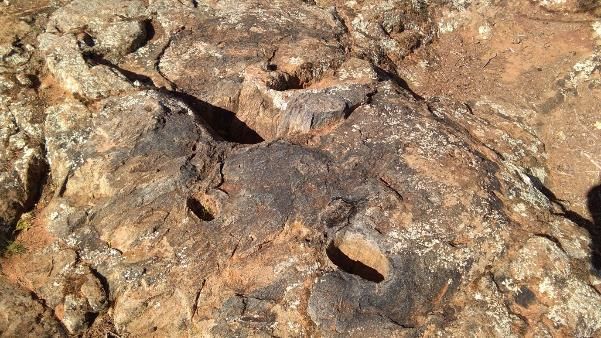
Tollingo Nature Reserve and Woggoon Nature Reserve Draft Planning Considerations

Figure 2   Map of Woggoon Nature Reserve

                                                  vii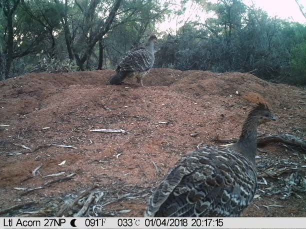
Tollingo Nature Reserve and Woggoon Nature Reserve Draft Planning Considerations

1.     Tollingo Nature Reserve and Woggoon
       Nature Reserve
Tollingo and Woggoon nature reserves (also referred to as Tollingo and Woggoon in this
document) are in Central West NSW, 40–55 kilometres north-west of Condobolin and
approximately 33 kilometres from Mount Tilga, the geographical centre of New South Wales.
Woggoon Nature Reserve is approximately 6373 hectares and Tollingo Nature Reserve is
approximately 3232 hectares (see Figures 1 and 2). The reserves are separated from each
other by approximately 10 kilometres at the nearest point.
Tollingo was the name of one of 59 parishes in the County of Cunningham, proclaimed in
1862. Woggoon is attributed to mean ‘scrub turkey’ in an Aboriginal language. The reserves
were formerly Crown land held under various Crown leases, including scrub leases and
special leases, dating from the early 20th century. Tollingo Nature Reserve was reserved in
1988 and Woggoon Nature Reserve was reserved in 1974. Additions to Woggoon were
reserved in 1981.
Tollingo and Woggoon are in the Cobar Peneplain Bioregion (Thackway & Cresswell 1995).
The Cobar Peneplain Bioregion is one of the most poorly conserved bioregions in New
South Wales, with just 2.6% conserved. Approximately 33% of the bioregion has been
cleared of vegetation, 25% is under intensive agricultural production and 14% is subject to
mining (EPA 2015).
Mount Nobby State Forest borders Woggoon Nature Reserve on its north-east corner. The
land on all other boundaries of both reserves has been extensively cleared, predominantly
for cropping and grazing. As a result, the reserves exist in a mosaic of cleared agricultural
lands interspersed with sparsely vegetated road corridors and windbreaks (see Figure 3).
This level of clearing and modification has resulted in a high loss of biodiversity and
fragmentation of habitat (DECC 2006; Keith 2004; Cunningham et al. 1992). The reserves
are relatively isolated and subject to edge effects, making them more vulnerable to intrusions
and disturbances.
The reserves are typical of the Cobar Peneplain Bioregion, which is characterised by low
relief and a semi-arid climate. Mean daily temperatures range from 15–34°C maximum and
2.8–18.5°C minimum, and mean annual rainfall is only 449 millimetres. The landscape
consists of flat to gently undulating red soil, sandy plains.
Due to the high level of disturbance and loss of natural areas in the region, these reserves of
largely intact remnant native vegetation are of high importance. They support vital
ecosystem processes and provide foraging, nesting and refuge sites for native species that
are in short supply in other parts of the landscape. They also support native plant
communities that are restricted in their extent or no longer exist elsewhere. Long-term
conservation of biodiversity in this region depends on the protection, enhancement and
connection of remaining habitat, incorporating vegetation remnants on public and private
lands.

                                                  1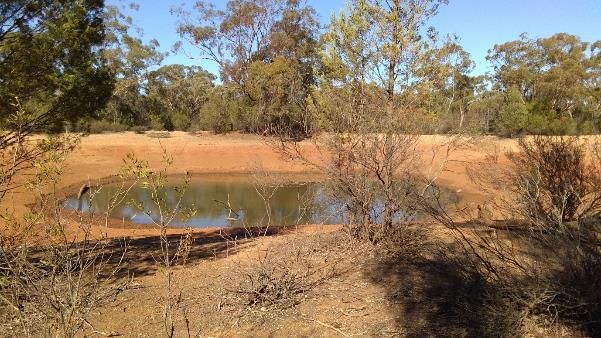
Tollingo Nature Reserve and Woggoon Nature Reserve Draft Planning Considerations

Figure 3   Air photo image showing the reserves in a mosaic of agricultural land (2016)

                                                  2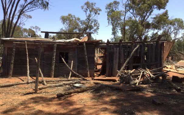
Tollingo Nature Reserve and Woggoon Nature Reserve Draft Planning Considerations

2. Protecting the natural environment

2.1    Geology and landform
The reserves lie within the Cobar Peneplain Bioregion on the eastern edge of the South
Western Plains botanical subdivision, close to the border of the NSW South Western Slopes
Bioregion.
The Cobar Peneplain is a distinctive landscape of undulating downs and flat plains
punctuated by stony ridges and ranges, and is formed on the north-westerly extension of the
Lachlan Fold Belt. The majority of the Peneplain is ‘red country’, characterised by shallow,
red soils and aeolian (windblown) sands associated with the Darling River and the Murray
Basin mantle in the west and south, and alluvium (material deposited by water) from the
Bogan River in the east. The area where the reserves are located marks the beginning of the
red sandy soils of the mallee sand plains, which develop into extensive dunefield systems
further west.
The reserves are within the Lachlan River catchment and approximately 25 kilometres from
the Lachlan River to the south. Within the reserves, and typical of the Cobar Peneplain, the
landscape is very flat with no clearly defined drainage lines. Areas surrounding Woggoon
Nature Reserve support ephemeral drainage lines and gilgais, most of which peter out
before reaching a watercourse. The only named watercourse in the vicinity of the reserves is
Tinda Creek, a narrow, confined creek that forms the eastern edge of Tollingo Nature
Reserve, extending north and south of the reserve.
There are two dams in Woggoon Nature Reserve. Towards the north-west corner, Caskeys
Dam holds water through most seasons. The smaller dam at the southern tip of the reserve
is likely to dry up under extended dry conditions. Neither of these dams is considered a
reliable source of water for firefighting purposes. There are no dams within Tollingo Nature
Reserve.
The underlying geology of the reserves is mainly unconsolidated material dating from the
Quaternary period of the Cainozoic era, 65 million years ago. This material ranges from clay
to sand to gravel, derived by in situ weathering or weathering plus gravitational movement
(eluvium) or deposited by flowing water (alluvium). This unconsolidated material differs from
consolidated material because it has not hardened to form rock, and groundwater can flow
through spaces between the grains. On these flat landforms, the soils are mainly alkaline red
earths and sands, often containing quartz and ironstone. These soils are deep and well-
draining sands to loamy sands. A small proportion of deep and hard-setting sandy loam to
clay-loam soil occurs on the lower areas of the landscape, such as the depressed flats and
shallow drainage lines (Porteners 2001).
In contrast to the surrounding flatness, a small rounded hill rises to 260 metres ASL in the
north-west corner of Woggoon Nature Reserve (see Figure 3). This outcrop was formed by
volcanic activity in the Early Devonian period of the Palaeozoic era. It consists mainly of tuff,
a light porous rock formed by consolidation of volcanic ash ejected from a vent during a
volcanic eruption, and some minor siltstone. As there is no other rock in the reserve, this
formation is significant as a source of rock used by Aboriginal people in the past (see
Section 3.1) and contributes significantly to reptile habitat (see Section 2.3).

2.2 Native plants
The reserves are within the South Western Plains botanical subdivision. Native vegetation in
this area has been severely depleted by clearing and grazing resulting in extreme
fragmentation and discontinuity. Although small in comparison with other similar reserves in
the region (such as Yathong, Nombinnie and Round Hill nature reserves), Tollingo and

                                                  3
Tollingo Nature Reserve and Woggoon Nature Reserve Draft Planning Considerations
Woggoon nature reserves have high conservation values as two of the largest and
easternmost sand plain mallee remnants within New South Wales, and all vegetation
communities within the reserves are considered significant due to their remnant status
(Porteners 2001).
In 2001 a comprehensive flora survey, including vegetation mapping, was undertaken for the
reserves (Porteners 2001). This survey identified four vegetation communities:
• Mallee Shrubland (approximately 2760 hectares in Tollingo and 5340 hectares in
Woggoon)
• Poplar Box Woodland
• Red Box – Mallee Woodland
• Grey Box Woodland (Woggoon Nature Reserve only).
These communities are described in detail in Appendix C.
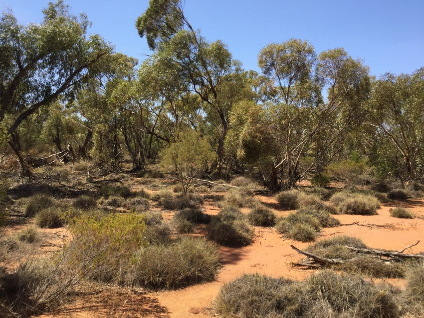
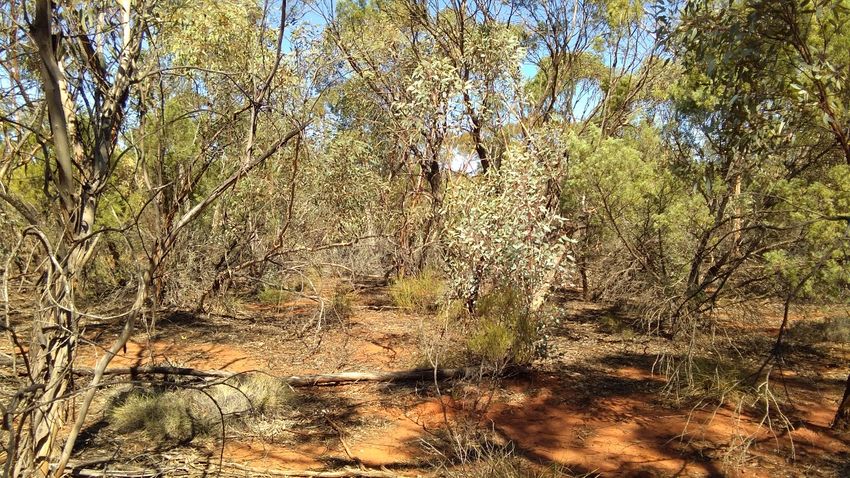
Photo 1 Mallee Shrubland community typical of Woggoon Nature Reserve. C Davis/DPIE.
Mallee refers to semi-arid systems dominated by eucalypt species that produce multiple
stems from an underground lignotuber. The reserves are considered to be excellent
examples of the mallee shrubland and woodlands of Central West NSW. In these reserves,
mallee vegetation includes red mallee, white mallee, narrow-leaved red mallee and mallee
pine and is of a sufficiently old age-class to provide valuable habitat for mallee specialists
and other native animals (Porteners 2001). It is this vegetation that provides habitat for the
endangered malleefowl (see Box 1). The mallee communities in Tollingo and Woggoon
nature reserves are very similar but not identical in vegetation composition, with several
species also unique to each reserve (Porteners 2001).
Box woodlands occur on fertile soils and are considered to be among the most threatened
and poorly conserved vegetation types in Australia. Regionally these woodlands have been
severely affected by land clearing, grazing, mining, forestry and altered fire regimes. Isolated
remnants are degraded by introduced herbivores, competition by introduced grasses and
spray drift.
4Tollingo Nature Reserve and Woggoon Nature Reserve Draft Planning Considerations
The fourth community, Grey Box Woodland occurs only in Woggoon Nature Reserve and is
considered to be part of the Inland Grey Box Woodland in the Riverina, NSW South Western
Slopes, Cobar Peneplain, Nandewar and Brigalow Belt South Bioregions Endangered
Ecological Community (EEC).
Woggoon Nature Reserve supports 163 species of native plants and Tollingo Nature
Reserve supports 121 species of native plants. While none are listed as threatened under
the Biodiversity Conservation Act 2016 (BC Act), 21 species of regional significance were
recorded during the 2001 vegetation survey (see Table 1).
Protection of regionally significant species is desirable to conserve the genetic variation
within their range and ensure their continued existence within New South Wales. Given the
parks’ relatively small sizes, remote locations and visitation patterns, the approach to
vegetation management will be to observe and record changes in the park as a result of
environmental conditions and events and undertake recurrent NPWS pest and weed control
programs.
Table 1 Regionally significant plants in the reserves
Common name Reserve
Restricted distribution within the Western Division of NSW
Common sourbush (or berry broombush) Tollingo, Woggoon
Mallee box Tollingo, Woggoon
Heath everlasting Woggoon
Downy wax flower Tollingo
Restricted distribution within the Western Plains region of NSW
Wyalong wattle Woggoon
Haviland’s wattle Tollingo, Woggoon
Grey ray flower Woggoon
Small-leaf everlasting Tollingo, Woggoon
Small-leaved mint bush Tollingo, Woggoon
Mallee copperburr Woggoon
Red-berried stick-plant Tollingo, Woggoon
Spiny mallee pea Tollingo, Woggoon
Species growing at their geographical limits of distribution
Ivy goodenia Tollingo, Woggoon
Pale mat-rush Tollingo, Woggoon
Poranthera microphylla Tollingo, Woggoon
Grey wrinklewort Tollingo
Cactus pea Tollingo, Woggoon
Native pear Tollingo
Climbing purple-star Tollingo
Mallee fringe lily Tollingo
Native blackthorn Tollingo, Woggoon
Source: Porteners 2001
5Tollingo Nature Reserve and Woggoon Nature Reserve Draft Planning Considerations
2.3 Native animals
As remnant vegetation in an extensively cleared and fragmented landscape, Tollingo and
Woggoon nature reserves provide valuable habitat for native animals that was formerly more
widespread in Central West NSW. Old-growth vegetation and a plentiful layer of fallen
branches and ground litter throughout the reserves enhance their value as habitat in a
cleared landscape.
Knowledge about the native animals of the reserves derives mainly from BioNet Atlas (DPIE
2019) and the results of a fauna survey undertaken in Woggoon Nature Reserve in 2008
(DECCW 2008). There are more records for birds and bats than other animal groups,
reflecting the ability of more-mobile species to travel between vegetated remnants and
optimise their use of scarce resources. Other less-mobile native animals such as ground-
based mammals have a greater reliance on remnant vegetation for refuge and are subject to
edge effects.
In Woggoon Nature Reserve, 144 native animal species have been recorded including 121
birds, 15 mammals and eight reptiles. In the absence of a fauna survey for Tollingo Nature
Reserve, records are considerably fewer. BioNet Atlas records a total of 57 native animal
species, which includes 50 birds, six mammals and one reptile.
Animals most readily seen in the two reserves are woodland birds and macropods. Sightings
of spiny-cheeked honeyeater, rufous whistler, red-capped robin and crested bellbird are
common. Birds recorded in the reserves include a number of nomadic and migratory species
that use the reserves as ‘stepping stones’, such as sacred kingfisher, rainbow bee-eater,
noisy friarbird, striped honeyeater, restless flycatcher, various woodswallows and jacky
winter.
The rocky hill and dams in Woggoon Nature Reserve are significant in enhancing available
habitat for reptiles and amphibians. Reptiles recorded include the southern spiny-tailed
gecko, tree dtella, barred wedgesnout, tree skink and wood mulch-slider. Amphibians
recorded following wet conditions include the green tree frog, Peron’s tree frog, desert tree
frog, giant banjo frog and spotted grass frog.
Photo 2 Fallen timber and coarse woody debris in Woggoon Nature Reserve. C Davis/DPIE.
6Tollingo Nature Reserve and Woggoon Nature Reserve Draft Planning Considerations
A total of 21 threatened animals listed under the BC Act and/or the Environment Protection
Biodiversity Conservation Act 1999 (EPBC Act) have been recorded in the reserves (see
Table 2). Tollingo and Woggoon nature reserves are significant for providing habitat for
malleefowl as there are only a handful of reserves where this species is recorded.
Malleefowl are listed as endangered at the state level and vulnerable at the national level
(see Box 1 for more information).
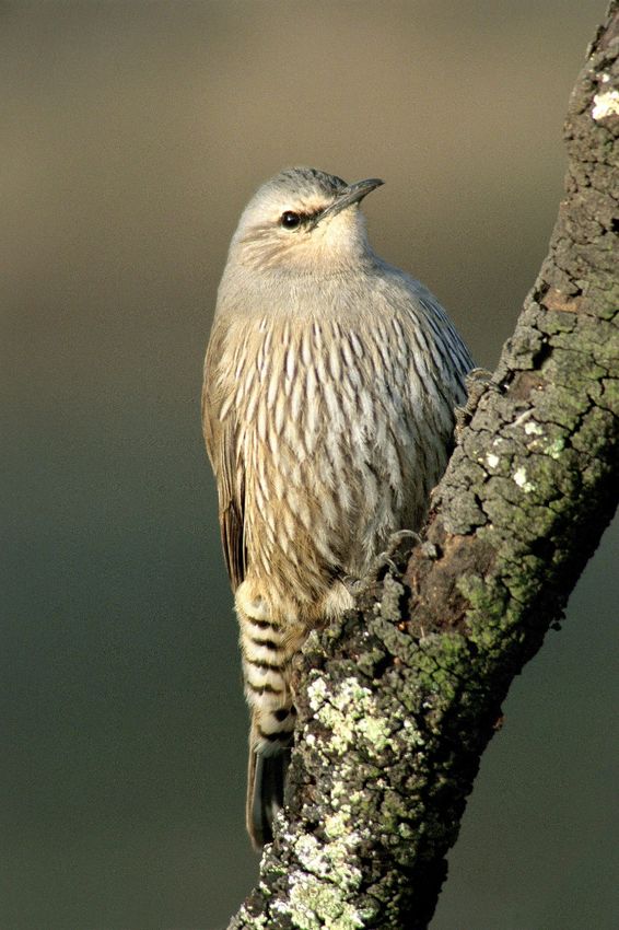
The reserves also support a suite of threatened woodland birds including diamond firetail,
grey-crowned babbler, hooded robin and brown treecreeper. Clearing and fragmentation of
woodland, open forest, grassland and mallee habitats is a major threat to woodland birds.
Loss of coarse woody debris (litter and fallen timber) through grazing by livestock, firewood
collection and too-frequent fires all result in degradation of important ground habitat
components.
Photo 3 Pied honeyeater. Richard Waring.
Strategies for the conservation of threatened species, populations and ecological
communities are set out in a statewide Biodiversity Conservation Program (OEH 2017a).
Actions listed in strategies are prioritised and implemented through the Saving our Species
program, which aims to maximise the number of threatened species that are secured in the
wild in New South Wales for 100 years (OEH 2013c). As at 2020, there are no Saving our
Species projects in the reserves.
Many recovery plans for NSW threatened species have previously been prepared and may
still provide useful information but they no longer determine the actions required for the
conservation of threatened species in New South Wales. The Commonwealth prepares
recovery plans for nationally listed threatened species under the EPBC Act. A national
recovery plan has been prepared for the endangered malleefowl to consider its management
needs in more detail (Benshemesh 2007).
7Tollingo Nature Reserve and Woggoon Nature Reserve Draft Planning Considerations
Table 2 Threatened animals in the reserves
Common name Reserve BC Act EPBC Act
status status
Birds
Black falcon Woggoon V
Brown treecreeper (eastern Tollingo and Woggoon V
subspecies)
Chestnut quail-thrush Woggoon V
Diamond firetail Woggoon V
Dusky woodswallow Woggoon V
Gilbert’s whistler Tollingo and Woggoon V
Grey-crowned babbler (eastern Woggoon V
subspecies)
Hooded robin (south-eastern form) Tollingo and Woggoon V
Little eagle Woggoon V
Major Mitchell’s cockatoo Woggoon V
Malleefowl Tollingo and Woggoon E V
Pied honeyeater Woggoon V
Shy heathwren Tollingo and Woggoon V
Speckled warbler Woggoon V
Spotted harrier Woggoon V
Superb parrot Woggoon V V
Varied sittella Woggoon V
Bats
Corben’s long-eared bat Tollingo and Woggoon V V
Inland forest bat Tollingo and Woggoon V
Little pied bat Woggoon V
Yellow-bellied sheathtail bat Woggoon V
Source: BioNet Atlas search (DPIE 2019), fauna survey of Woggoon Nature Reserve (DECCW 2008), pied
honeyeater record from Cowra Woodlands Bird Program (2012).
8Tollingo Nature Reserve and Woggoon Nature Reserve Draft Planning Considerations
Box 1. Malleefowl
The malleefowl is a large and distinctive ground-dwelling bird that has become endangered in New
South Wales over the last 100–150 years through land clearance and fox predation. In many areas
there has been such loss and fragmentation of their habitat that remaining populations are small
and isolated, food sources have been depleted and there is an increased risk of predation by foxes
(Benshemesh 2007; NPWS 2001).
Apart from habitat loss, fragmentation and degradation, malleefowl populations are also threatened
by (OEH 2017b):
• fire, which removes litter for mound construction, shelter from predators and food sources,
especially seeds (mounds are not usually constructed in an area within 15–20 years after a fire
and it may be 40 years before maximum densities are attained)
• predation, mainly by foxes and cats but also birds of prey that target eggs and chicks
• vehicle strike when birds crossroads or feed on spilt grain beside roads
• climate change, which in the long term may alter habitat characteristics preferred by the species
such that its capacity to support viable populations is reduced
• feral goats competing for food and disturbing nesting mounds
• feral pigs disturbing nesting mounds
• sheep grazing of habitat on private land.
Malleefowl are being managed by National Parks and Wildlife Service (NPWS) in some NPWS
reserves as an iconic endangered species under the Saving our Species program and in
accordance with a national recovery plan for malleefowl (Benshemesh 2007). Key management
actions under the program are control of foxes and other predators, control of feral goats and fire
management. NPWS has released captivity-bred birds into Yathong Nature Reserve, another
significant mallee reserve in western NSW in an attempt to make the population of malleefowl more
secure.
Malleefowl recorded at a mound in Woggoon Nature Reserve by remote camera. DPIE.
NPWS reviews all aspects of the malleefowl program under an adaptive management approach
that takes account of new technologies, such as remote sensing, and changing parameters, such
as the emergence of pigs as a pest in the mallee lands.
9Tollingo Nature Reserve and Woggoon Nature Reserve Draft Planning Considerations
2.3.1 Management considerations and opportunities
Given the reserves’ relatively small sizes, remote locations and visitation patterns, the
approach to native animal management will be to observe and record changes in the
reserves as a result of environmental conditions and events, undertake recurrent NPWS
pest control programs and seek additional management resources for specific species, such
as through NPWS Biodiversity Conservation Program and NSW Saving Our Species
program. As at 2020, Tollingo and Woggoon nature reserves were not identified as key
management sites under the NPWS Saving our Species program.
Concerning malleefowl, research and monitoring being conducted at key management sites
such as Yathong Nature Reserve and Mallee Cliffs National Park has determined that, as
with other specialists in the semi-arid zone, breeding activity is strongly linked to the age-
class of mallee habitat, frequency of fire and the timing (both frequency and season) of
rainfall.
The presence of malleefowl and the integrity of old-growth mallee vegetation were significant
factors which led to the reservation of Tollingo and Woggoon nature reserves. Old-growth
mallee with a spinifex understorey is the preferred habitat for malleefowl in the reserves.
However, the size of the population and successful use of mounds in the reserves by
malleefowl is uncertain. In the absence of systematic targeted surveys, it is not possible to
define the populations and their use of the reserves. However, birds were recorded in both
reserves as recently as 2018 from a combination of footprints and remote camera
monitoring. NPWS continues to seek additional resources for increased monitoring to
provide more information about malleefowl in the reserves so that appropriate management
measures can be applied. Pest animal control is the key management effort applied to
promote the persistence of malleefowl in the reserves and has flow-on benefits for other
species (see Section 2.5).
2.4 Weeds and pest animals
The Biosecurity Act 2015 and its regulations provide specific legal requirements for the
response, management and control of biosecurity risks, including weeds and pest animals.
These requirements apply equally to public land and privately-owned land. Under this
framework, Local Land Services has prepared regional strategic weed management plans
and regional strategic pest animal management plans for each of its 11 regions.
The Central West Regional Strategic Weed Management Plan 2017–2022 (Central West
LLS 2017) and Central West Regional Strategic Pest Animal Management Plan 2018–2023
(Central West LLS 2018) identify priority weeds and pest animals for the region and
appropriate management responses (i.e. prevention/alert, eradication, containment or asset
protection).
Previously the NPWS regional pest management strategy for the Western Rivers region
(OEH 2013b) identified pest species and priority programs for Tollingo and Woggoon nature
reserves. A new pest management strategy is being developed for the reserves by NPWS
which will be consistent with the priorities of the Local Land Services’ regional strategic pest
and weed management plans, as well as other important programs such as the Biodiversity
Conservation Program (see Section 2.3).
The overriding objective of the pest management strategy is to minimise adverse impacts of
introduced species on biodiversity and other reserve and community values while complying
with legislative responsibilities. Additional programs may also be undertaken in cooperation
with neighbouring land managers in response to emerging issues.
10Tollingo Nature Reserve and Woggoon Nature Reserve Draft Planning Considerations
Weeds
Relatively few weeds are present in the reserves. The most common weeds are those
dependent on suitable seasonal conditions including horehound, Paterson’s curse, saffron
thistle, fleabane and capeweed. None of these weeds are listed as priority species under the
regional Local Land Services plan.
Weeds occur only in small isolated patches and tend to be associated with areas that have
been previously cleared and grazed, are on the boundaries of the reserves or along
management trails. Overall, weeds are not having a major impact on natural and cultural
values in the reserves. Weed infestations are monitored and treated as necessary.
Pest animals
Several introduced pest animals impact the reserves’ natural and cultural heritage values,
including foxes, goats, cats, pigs and rabbits. The impacts of these species are identified as
key threatening processes under the BC Act and/or the EPBC Act and all of these species
are listed as regional priorities for control (Central West LLS 2018).
Foxes constitute a major threat to malleefowl in the parks. Foxes suppress native animal
populations, particularly small to medium-sized, mammals, ground-nesting birds and
freshwater turtles. Together with cats, foxes are known to have caused the decline and
extinction of many native species. Foxes also prey on domestic stock. Foxes are highly
mobile and can rapidly repopulate treated areas.
A systematic ground-baiting strategy for foxes is applied in both reserves (OEH 2013b),
using buried baits and spring-activated devices known as canid pest ejectors. These
methods have proven to be environmentally safe and effective, particularly if baiting is done
in cooperation with neighbouring landowners.
Feral goats are frequently sighted in the reserves, though not in large numbers and there is
no visible browse line in the native vegetation. Goats are suspected of competing with
malleefowl for food resources and could also potentially damage Aboriginal cultural material.
Feral goats are a significant problem in the semi-arid regions of central and western NSW,
particularly as they can tolerate extended dry conditions and are unimpeded by standard
stock fencing. Their foraging habits are extremely destructive, they can breed rapidly and
they can cover many kilometres in a day. Grazing by feral goats can severely impact the
regeneration of many plant species and sustained use of an area by goats results in erosion.
Feral goats are identified as a priority pest animal in the Central West Regional Strategic
Pest Animal Management Plan (Central West LLS 2018). The impact of feral goats has been
listed as a key threatening process under the BC Act and EPBC Act (NSW SC 2004a; DoE
2009). The feral goat is identified as one of the 100 worst invasive species in the Global
Invasive Species Database (IUCN 2017).
At this stage, the number of goats does not appear to warrant active control. As with other
pest animals, neighbouring landowners are encouraged to carry out goat control on their
lands in cooperation with NPWS, however many landowners view feral goats as a ready
source of revenue, especially in marginal grazing country.
Together with foxes, feral cats are known to have caused the decline of many native
species including extinctions of mammals and birds on islands. They are responsible for the
failure of many threatened species’ reintroduction programs and continue to pose a serious
threat to Australian wildlife (Short et al. 1992 and Priddel & Wheeler 2002, both cited in
Moseby & Hill 2011). Predation by feral cats has been listed as a key threatening process
under both the BC Act and the EPBC Act (NSW SC 2000c; DoE 2009). Feral cats are also
identified as a priority pest animal in the Central West Regional Strategic Pest Animal
Management Plan (Central West LLS 2018).
11Tollingo Nature Reserve and Woggoon Nature Reserve Draft Planning Considerations
Cats are exceptionally good hunters and can endure the harsh conditions of the arid outback
where other predators fail. The way cats move through the landscape is also less predictable
than for foxes, which tend to use trails and roads. Cost-effective, large-scale control methods
for feral cats are not yet available. Shooting at night with spotlights has historically been
carried out and poison baiting for feral cats has had a measure of success in confined areas.
Preliminary work is being undertaken to develop new types of cat bait such as ‘Curiosity’
(DoEE n.d.) and specially designed cat-baiting stations.
As at 2020, no control of cats is being undertaken in Tollingo and Woggoon. Feral cats have
been recorded within Woggoon Nature Reserve and are likely to be a serious threat to
malleefowl as well as to woodland birds and other animals.
Feral pigs can have a substantial impact on conservation values through their foraging,
wallowing and digging behaviours. They cause major disturbance and damage to soils,
roots, sensitive ground flora and wetland environments. Areas disturbed by feral pigs are at
risk from subsequent weed invasion and soil erosion. Feral pigs are also a potential host of a
number of exotic diseases. They are identified as a priority pest animal in the Central West
Regional Strategic Pest Animal Management Plan (Central West LLS 2018).
Predation, habitat degradation, competition and disease transmission by feral pigs is listed
as a key threatening process under both the BC Act and the EPBC Act (NSW SC 2004b;
TSSC 2001b).
Dry conditions have tended to limit pig numbers in the reserves, but they have been
recorded passing through the reserves during and after wet conditions. At times feral pigs
are known to be an issue for neighbours and cooperative control is, and will continue, to be
undertaken using pig traps on adjacent properties. The presence of pigs in the reserves
commonly attracts illegal pig hunting and damage to gates and fences can result. Control of
pigs will continue to be carried out by NPWS as required.
Photo 4 Pigs on a malleefowl mound in Woggoon Nature Reserve, October 2011. DPIE.
Rabbits accelerate erosion by removing plant cover. They are also suspected of being an
important cause in the decline, and limited regeneration, of many native plant species in
semi-arid habitats including cypress pine, wattles, hakeas and belah/rosewood communities.
Rabbits are a major food source of large predators, notably foxes and eagles, although
12Tollingo Nature Reserve and Woggoon Nature Reserve Draft Planning Considerations
predation by these animals alone does not significantly reduce rabbit numbers. Rabbits have
been implicated in modifying habitat and reducing food resources important for malleefowl.
Wild rabbits are identified as a priority pest animal in the Central West Regional Strategic
Pest Animal Management Plan (Central West LLS 2018). Competition and grazing by the
feral European rabbit is listed as a key threatening process under the BC Act and the EPBC
Act (NSW SC 2002; DoE 2009).
In Tollingo and Woggoon it appears rabbits once favoured the sandy clay soils associated
with white cypress pine-dominated areas of Open Box Woodland. Rabbit warrens in the
southern section of Woggoon were ripped and fumigated in the early years of the reserve
but no rabbit control has been required in recent years. Rabbit activity will continue to be
monitored in the reserves and control measures undertaken as required.
2.5 Fire management
The primary objectives of NPWS fire management are to protect life, property and
community assets from the adverse impacts of fire, while also managing fire regimes in
parks to maintain and enhance biodiversity.
A fire management strategy which defines the fire management approach is prepared for
each reserve and is updated periodically (OEH 2014b, c). These strategies outline the recent
fire history of the reserves, key assets within and adjoining the reserves including sites of
natural and cultural heritage value, fire management zones and fire control advantages such
as management trails and water supply points. The strategies also contain fire regime
guidelines for conservation of the vegetation communities found in the reserves based on
biodiversity thresholds.
Details about how fire is managed in the reserves are included in Box 2, including
recommended fire intervals for the various vegetation communities.
Photo 5 Mallee shrubland, Woggoon Nature Reserve. M Billington/DPIE
13Tollingo Nature Reserve and Woggoon Nature Reserve Draft Planning Considerations
Box 2. Fire in the reserves
Aboriginal people are known to have used fire across the Australian continent to promote food
animals and other resources by deliberate burning of known habitats, sometimes at a small or very
small scale. The Aboriginal fire regimes for semi-arid mallee communities are not well known.
Fire remains an integral part of the Australian environment. It is a major factor in determining the
structure and species composition of native vegetation and has long-term effects on animal
populations. However, inappropriate fire regimes can lead to impacts on and loss of particular plant
and animal species and communities, and high-frequency fires have been listed as a key
threatening process under the BC Act (NSW SC 2000b).
Mallee ecosystems are fire prone and fire in this landscape is a key driver of ecological change. As
part of its ongoing responsibilities as a fire authority and land manager, NPWS monitors the
condition of vegetation in the reserves, particularly through prolonged dry periods. NPWS develops
and implements fire management practices that contribute to conserving biodiversity and cultural
heritage across the landscape; and undertakes cooperative and coordinated fire management with
other fire authorities, neighbours and the community (OEH 2013a). A fire management strategy that
defines the fire management approach for each reserve has been prepared and is updated
periodically (OEH 2014b, c).
Research is being undertaken to understand the effects of fire on plants and animals in mallee
ecosystems and develop an appropriate fire regime that will not compromise significant
conservation values. Research carried out by NPWS in Tarawi Nature Reserve and Mallee Cliffs
National Park, as well as the Mallee and Fire Biodiversity Project (La Trobe University 2019) has
contributed significantly to the understanding of fire in mallee ecosystems.
In mallee vegetation communities, habitat and fuel characteristics such as leaf litter, hollows,
canopy cover and height, bark and spinifex cover all increase in the first 35 years after fire. From
about 35 years to 100 years after fire, these characteristics provide optimum habitat for a large
number of species including several threatened species. Maximum fuel loads are also attained by
35 years and they remain high for at least another 65 years (Haslem et al. 2011). Mallee-dominated
vegetation communities contain plant species that are generally fire tolerant and some plants might
be considered fire dependent, but ongoing research has demonstrated that there is no minimum or
maximum fire interval required for the perpetuation of these communities.
In addition to semi-arid woodlands, Woggoon Nature Reserve contains grassy woodlands for which
the preferred fire interval is 8–40 years.
In Central West NSW, wildfire is usually ignited during dry lightning storms when daytime
temperatures are high and humidity is low, especially when these conditions follow winter rains that
have resulted in grass growth creating a continuous fuel layer. Tollingo and Woggoon nature
reserves have historically had a very low frequency of wildfires and the majority of vegetation is
long unburnt. No major wildfires have been recorded in Woggoon Nature Reserve and the only
known major wildfire in Tollingo Nature Reserve was in 1979–80. This fire burned approximately
945 hectares of the reserve.
There is no major infrastructure in either of the reserves and there is no adequate source of
permanent water available for firefighting. For fire management purposes, the reserves are each
identified as a land management zone, and NPWS fire management focuses on conserving
biodiversity values, especially malleefowl habitat. Malleefowl prefer a dense but discontinuous
canopy and dense and diverse shrub and herb layers. They can use recently burnt areas for
foraging, but unburnt habitat is essential for roosting, daytime shelter and nesting.
The fire strategies for the reserves aim to avoid fire in old-age mallee while also maintaining a mix
of age classes in the vegetation. This approach is designed to promote habitat diversity in both
shrubby semi-arid woodlands and grassy woodlands to benefit a range of animals, and to help build
resilience and refugia in a region where mallee ecosystems have been greatly reduced. Prescribed
burns in a mosaic pattern may be carried out from time to time in the reserves to benefit malleefowl
and other conservation values.
In Woggoon Nature Reserve an asset protection zone has been identified around the site of Watts
Hut, and a strategic fire advantage zone along the powerline corridor. In Tollingo, several
management trails are identified as strategic fire advantage zones.
NPWS maintains cooperative arrangements with surrounding landowners and the Rural Fire
Service and is a member of the Mid Lachlan Valley Team Bush Fire Management Committee.
14Tollingo Nature Reserve and Woggoon Nature Reserve Draft Planning Considerations
2.6 Climate change
Human-induced climate change is listed as a key threatening process under the BC Act
(NSW SC 2000a) and habitat loss caused by human-induced greenhouse gas emissions is
listed under the EPBC Act (TSSC 2001a). NPWS’s approach to managing climate change in
the reserves is outlined in Box 3.
Photo 6 Brown treecreeper (eastern subspecies). Hellen Fallow/DPIE
15Tollingo Nature Reserve and Woggoon Nature Reserve Draft Planning Considerations
Box 3: Climate Change
Climate change modelling has been produced for 12 defined regions in south-east Australia. The
following is a snapshot of the predicted changes to climate for the Central West and Orana Region,
which covers Tollingo and Woggoon nature reserves (OEH 2014a):
Maximum temperatures are projected to Maximum temperatures are projected to
increase in the near future by 0.4–1.0°C increase in the far future by 1.8–2.7°C
Minimum temperatures are projected to Minimum temperatures are projected to
increase in the near future by 0.5–0.9°C increase in the far future by 1.5–2.6°C
The number of hot days (i.e. > 35°C) will The number of cold nights (i.e. < 2°C) will
increase decrease
Rainfall is projected to decrease in Rainfall is projected to increase in
spring autumn
Average fire weather is projected to Severe fire weather is projected to
increase in summer, spring and winter increase in summer, spring and winter
Source: OEH 2014a. ear future=2020-2039
Far future=2060–2079
The projected changes that are likely to have the greatest effects on the reserves are increases in
temperature, the number of hot days and fire weather. Evaporation rates will in turn increase and
create drier soil conditions throughout the year. Historically, the region experiences more than 30
very high to extreme fire danger days every year. The number of very high to extreme fire danger
days is projected to increase by 10–50% and the conditions conducive to large and intense fires,
such as prolonged drought, low humidity, number of hot days and high wind speeds, will more than
likely increase (DECCW 2010b). This has implications for the ground-nesting malleefowl and
threatened woodland birds, which rely on long unburnt habitats and a mosaic burning pattern to
maintain critical resources (see Section 2.3).
Climate change may affect biodiversity significantly by altering the size of populations, the
distribution of species and the geographical extent and species composition of habitats and
ecosystems. Species most at risk are those unable to disperse or adapt, particularly those with
small population sizes such as malleefowl, or with slow population growth rates.
The brown treecreeper and grey-crowned babbler are examples of species recorded in the
reserves whose distribution may change under climate change. The western boundary of the range
of the brown treecreeper (eastern subspecies) runs approximately 100 kilometres to the east of
Woggoon Nature Reserve, roughly through Corowa, Wagga Wagga, Temora, Forbes, Dubbo and
Inverell. Along this line the subspecies intergrades with the arid zone brown treecreeper
subspecies. As climate change progresses and conditions become drier, the western subspecies
could potentially spread further eastwards or the two subspecies could interbreed and the
distinction between them becomes redundant.
16Tollingo Nature Reserve and Woggoon Nature Reserve Draft Planning Considerations
Grey-crowned babbler. G Chapman.
The overall potential impact of climate change on the reserves is difficult to assess since it depends
on the compounding effects of other pressures, particularly barriers to dispersal and pressure from
introduced animals. Barriers to dispersal are a significant issue in extensively cleared and
fragmented landscapes, such as those in which Tollingo and Woggoon occur. Animal and plant
species in these areas are likely to be at greater risk of extinction than those in more intact
ecosystems.
The reserves have been managed as conservation reserves since 1988 (Tollingo) and 1974
(Woggoon) to remove or lessen the effect of threatening processes and protect and restore habitat
needed by native plants and animals. NPWS will continue management measures aimed at
avoiding fire in old-growth mallee to help build the resilience of the mallee ecosystems.
Continuation of programs to reduce the pressures arising from other threats, such as vertebrate
pests, are expected to help reduce the severity of the effects of climate change. However, it is a
challenge for NPWS to protect the reserves from the worst effects of climate change without
greater protection and enhancement of biodiversity values occurring more broadly across the
surrounding landscape.
17Tollingo Nature Reserve and Woggoon Nature Reserve Draft Planning Considerations
3. Looking after our culture and heritage
3.1 Aboriginal culture and heritage
Woggoon Nature Reserve is in the traditional Country of the Wiradjuri People and Tollingo
Nature Reserve is in shared traditional Country of the Wiradjuri and Ngiyampaa peoples.
What is ‘Country’? To Aboriginal people, the landscape is made up of many
interrelated features. These include land, water, plants and animals, places and stories,
historical and current uses, and people and their interactions with each other and place.
These features are central to Aboriginal spirituality and contribute to Aboriginal identity.
They are inseparable and make up what is known as ‘Country’.
The Wiradjuri People are known as the people of the three rivers. Their vast traditional
Country extends from the Great Dividing Range in the east, and is bordered by the
Macquarie, Lachlan and Murrumbidgee rivers. Ngiyampaa Country lies to the west of
Wiradjuri Country and is similarly defined by the landscape. It is roughly bounded by the
Darling, Barwon, Bogan and Lachlan rivers. Along these river corridors there is shared
Country.
Aboriginal people have cultural associations and connections to Country in the reserves
including the use and enjoyment of foods and medicines, caring for the land, passing on
cultural knowledge, kinship systems and strengthening social bonds. Aboriginal heritage and
connection to nature are inseparable and need to be managed in an integrated manner
across the landscape.
Within the reserves, plants such as sweet quandong and animals such as kangaroos and
echidnas were used for food. The medicinal plant sneezeweed is also abundant along
shallow drainage lines, particularly Tinda Creek.
Photo 7 Gnarma holes on the footslopes of the rocky rise in Woggoon Nature Reserve. M
Billington/DPIE.
18Tollingo Nature Reserve and Woggoon Nature Reserve Draft Planning Considerations
Aboriginal sites are places with evidence of Aboriginal occupation or places that are
related to other aspects of Aboriginal culture. They are important as evidence of
Aboriginal history and as part of the culture of local Aboriginal people.
Cultural heritage surveys were conducted in the reserves in 2010 and 2012 in conjunction
with the Condobolin Local Aboriginal Land Council and local community members. The
survey locations were prioritised using a pre-contact land-use model developed for Tollingo
and Woggoon nature reserves. The model identified environmental attributes such as
elevation, drainage and vegetation that are expected to have influenced past human
occupation of a landscape. The survey, therefore, targeted specific parts of the reserves
such as open woodland areas, creek lines and the rocky hill in Woggoon. To date, 34
Aboriginal sites have been identified in Tollingo and 28 in Woggoon, but many additional
unidentified sites are likely to be present. Of the recorded sites, the majority are modified
trees. Grinding grooves, a hearth and artefacts were also recorded.
The cultural heritage surveys revealed information about Aboriginal people’s approaches to
the use and conservation of natural resources. Most of the recorded sites are associated
with shallow and ancient stream beds that once crossed the landscape, or are around the
single granite outcrop that provides relief in an otherwise flat and level plain. Among the
rarer Aboriginal heritage sites are the gnarma (or gnamma) holes used for storing water in
Woggoon Nature Reserve. These holes are manmade and believed to have been created by
building very hot fires and then pecking out the rock fragments with harder materials. A flat
rock was often placed on top to prevent the water dying up. The presence of individual sites
and objects, in conjunction with areas of extended occupation and activity, suggest a strong
cultural connection to the land. The surveys also helped the local Aboriginal community to
reconnect with Country.
3.1.1 Management considerations and opportunities
Although the NSW Government has legal responsibility for the protection of Aboriginal sites
and places, NPWS acknowledges the right of Aboriginal people to make decisions about
their own heritage. It is therefore policy that Aboriginal communities be consulted and
involved in the management of Aboriginal sites, places and related issues, and in the
promotion and presentation of Aboriginal culture and history.
Tollingo Nature Reserve is within the area of a native title claim registered by the Ngemba
Ngiyampaa Wangaaypuwan and Wayilwan people (NC2012/001). As at 2020, this claim is
yet to be determined.
Trampling by feral goats may cause damage to Aboriginal cultural material at some of the
recorded Aboriginal sites.
3.2 Shared heritage
History has taken place across the landscape. This includes the history of the first
Australians - Aboriginal people - and our shared history since European settlement.
Cultural heritage comprises places and items that may have historic, scientific, cultural,
social, archaeological, architectural, natural or aesthetic significance. NPWS conserves
the significant heritage features of NSW parks and reserves.
19Tollingo Nature Reserve and Woggoon Nature Reserve Draft Planning Considerations
3.2.1 Settlement of the region
With the crossing of the Blue Mountains in 1813 and the construction of a road over the
mountains in 1815, pastoralist settlers were soon attracted to the flat Lachlan Plains.
Surveyor General of New South Wales John Oxley explored part of the Lachlan Plain in
1817. He made a large circuit from Forbes and Bogan Gate south-west to Griffith, north to
Lake Cargelligo and along the Lachlan River to Kiacatoo (Kass 2003), which is 40 kilometres
west of Condobolin and about 40 kilometres due south of Tollingo Nature Reserve.
This region was well beyond the ‘limits of settlement’ defined by the Nineteen Counties
declared by Governor Darling in 1826, and therefore the first European settlers in the area
would have been squatters. The continuing demand for pasture resulted in large sheep runs
being established throughout the NSW Central West, with most of the best land having been
taken up by the 1850s (Kass 2003). The passing of the Crown Lands Act 1861 brought an
end to squatting and introduced conditional purchase of Crown land, also known as ‘free
selection before survey’.
In the second half of the 19th century changes to legislation encouraged more intensive use
of smaller farms, resulting in the breaking up of large pastoral runs. The drier Lachlan area
was found to be suitable for wheat growing and as a result the region has been extensively
cleared. Wheat, other cereal crops and canola continue to be significant land uses.
In response to the voracious pace of land clearing for wheat, and the need to protect millable
timber, the Department of Lands declared a series of timber reserves in the Lachlan area in
the last 20 years of the 19th century. Mount Nobby State Forest was set aside in 1884 and
dedicated as state forest in 1913. The forest boundary was extended in 1949.
Photo 8 Description of scrub leases, from an early stock and station agent’s pamphlet
(Frost 1893).
3.2.2 History of the reserves
The land now in the reserves was formerly Crown land held under various leases of variable
size, including ‘scrub leases’ and ‘special leases’, which passed through a number of hands.
From time to time, requests were made by some leaseholders for the land to be proclaimed
as a ‘reserve’ which effectively quarantined the land from purchase. Granting of leases over
20Tollingo Nature Reserve and Woggoon Nature Reserve Draft Planning Considerations
the Crown land continued into the 1960s. In 1974 Woggoon Nature Reserve was gazetted,
followed by Tollingo Nature Reserve in 1988.
3.2.3 Shared heritage sites
There is little evidence of shared heritage in the reserves, but an early 20th century building
known as Watts Hut (or Harrys Hut) remains close to the northern boundary of Woggoon
Nature Reserve.
This site was settled as a small pastoral holding in 1924 by McPhillamy who built the original
dwelling in 1928. This structure burnt down sometime between 1930 and 1936. The
woolshed nearby was built in 1937 and, after the house burnt down a second time, a lean-to
shed was built onto the woolshed. The Crown lease over the property was left to Tom
Haddon of Condobolin and sold to the Watts family in 1936. It was occupied by the Watts
from 1937 until 1953 (OEH 2011).
Photo 9 Watts Hut 2019, Woggoon Nature Reserve. DPIE.
The woolshed and hut structure are of weatherboard and pine slab construction and
comprised four rooms: living; bedroom; a room that doubled as a bedroom and wool room;
and the shearing shed. Bins and sheep pens also formed part of the overall structure. The
dwelling section was a lean-to attached to the main gabled structure of the woolshed. Other
ancillary structures distributed around the site include the remains of a ground tank, orchard,
chook yards, cowshed, hand pump, a variety of sheds, old vehicles and machinery.
3.2.4 Management considerations and opportunities
An assessment of the heritage values of Watts Hut suggested the site is of local historic
significance (DEC 2002). Watts Hut and its surrounding infrastructure pose a potential safety
risk to staff and visitors to the reserve, as the main structure has collapsed, some of the
remaining rafters are rotten and the site is littered with iron debris and wire. The site is being
managed as a ruin.
21Tollingo Nature Reserve and Woggoon Nature Reserve Draft Planning Considerations
4. Providing for visitor use and enjoyment
The primary purpose of nature reserves is to conserve ecosystems, species, communities or
natural phenomena. They differ from national parks in that there is no requirement to provide
for visitor use in nature reserves. Research, educational use, nature study and enjoyment
are appropriate uses where they do not conflict with conservation.
Tollingo and Woggoon nature reserves generally experience low levels of visitation by
occasional groups of birdwatchers or walkers. Unauthorised access by public vehicles is not
allowed in the reserves and visitation is limited to self-reliant, passive, nature-based
activities.
As nature reserves, Tollingo and Woggoon will continue to be managed primarily for nature
conservation and related activities such as environmental education, nature appreciation and
research. There are currently no visitor facilities in the reserves, and none are proposed. A
range of recreational opportunities is available in other reserves in the region.
As significant patches of remnant mallee, Tollingo and Woggoon offer opportunities for
research of mallee ecosystems and the biodiversity they support, particularly the
endangered malleefowl. NPWS encourages environmental research and student fieldwork
training projects in the reserves provided they benefit NPWS management and do not cause
undue disturbance to reserve values or management operations. Monitoring and data
collection in Tollingo and Woggoon have the potential to supplement research conducted in
other mallee remnants and to answer questions about the persistence of malleefowl in
disjunct populations separated by large tracts of cleared farmland.
Photo 10 Typical management trail in the reserves. M Billington/DPIE.
Due to the remoteness of the reserves and absence of water, NPWS does not allow
camping in the reserves. Bush camping with prior consent from NPWS will only be
considered for conservation purposes, such as to facilitate overnight research activities.
22You can also read