BASIN BRIDGE PROJECT TECHNICAL REPORT 3 URBAN & LANDSCAPE DESIGN FRAMEWORK - Nzta
←
→
Page content transcription
If your browser does not render page correctly, please read the page content below
BASIN BRIDGE PROJECT
                                                             TECHNICAL REPORT 3 ͳ URBAN & LANDSCAPE DESIGN FRAMEWORK
                                                                                                                           prepared for:
                                                                                                                                  NZTA

 DATE       ISSUE              BY:    TO:
                                      Opus   NZTA       AC
 11.07.12   DRAFT FOR REVIEW   wala   1      -
 20.07.12   DRAFT FOR REVIEW   wala   1      -
 17.12.12   DRAFT FOR REVIEW   wala   1      1
 13.03.13   DRAFT FOR REVIEW   wala   1      1      1                                                              WALA REF: 0915_RT_35
 27.03.13   DRAFT FOR REVIEW   wala                 1

                                                                                               wā
 24.05.13   DRAFT FOR REVIEW   wala          1      1
 29.05.13   FOR LODGEMENT      wala          1      1
 06.06.13   FOR REVIEW         wala                 1
                                                                                                W RA I G H T +
 10.06.13   FOR LODGEMENT      wala          1                                                A S S O C I AT E S
                                                                                              LANDSCAPE
                                                                                              ARCHITECTS

J une 2 0 1 3                                                                                                                     P age 1
Client:
New Zealand Transport Agency (NZTA)

Consultant:
Wraight Athfield Landscape + Architecture Limited
PO Box 19212
Wellington

The following report has been prepared on behalf, and for the exclusive use of the New
Zealand Transport Agency (NZTA). Contributors to this report include:

John Hardwick Smith (Wraight Athfield Landscape + Architecture Ltd) - Author
Megan Wraight (Wraight Athfield Landscape + Architecture Ltd) - Author
Phil Mark (Wraight Athfield Landscape + Architecture Ltd) - Graphic editor
Jamie Roberts (Wraight Athfield Landscape + Architecture Ltd) - Graphic editor
Matt Pepper (Wraight Athfield Landscape + Architecture Ltd) - Graphic editor

Internal Reviewers
Megan Wraight (Wraight Athfield Landscape + Architecture Ltd)
Martin Bryant (Wraight Athfield Landscape + Architecture Ltd)
John Hardwick Smith (Wraight Athfield Landscape + Architecture Ltd)

External Reviewers
Greg Lee (NZTA) - Reviewer
Gareth Mckay (Opus International Consultants) - Reviewer
Alistair Aburn (Urban Perspectives) - Reviewer
Lucie Desrosiers (NZTA) - Reviewer

                                                                                          wā
                                                                                           W RA I G H T +
                                                                                         A S S O C I AT E S
                                                                                         LANDSCAPE
                                                                                         ARCHITECTS

Page 2                                                                                                        June 2013
0 CONTENTS
1 Introduction + Project Description 3.2 Culture and Heritage 3.8.7 Pedestrian Journey (south-north)
1.1 Purpose of the ULDF 3.2.1 tangata whenua 3.8.8 Pedestrian Journey (west-east)
1.2 Structure of the ULDF 3.2.2 Open Space Connections 3.8.9 Pedestrian Journey (east-west)
1.3 The Basin Bridge Project Objectives 3.2.3 Historical Connection to Water 3.8.10 Journeys Summary (NWM Park)
1.4 Receiving Environment (Relevant to the ULDF) 3.2.4 Historical Connection with City
3.2.5 Patterns of Age and Texture 4 Community Engagement
1.5 The Basin Bridge Project Description
3.2.6 Community Infrastructure 4.1 Historical Engagement
1.6 Transport Improvements
3.3 Urban Structure 4.2 Community Engagement Phases
1.7 Urban Design and Landscape
3.3.1 Summary 4.2.1 Phase 1 2011 - Objectives & Purpose
1.8 Previous Studies
3.3.2 Landform, Grids & Axis 4.2.2 Phase 1 2011 - Scope & Feedback
1.9 Ngauranga to Airport Corridor Plan
3.3.3 Urban Grain 4.2.3 Phase 2 2012 - Objectives & Purpose
1.10 Roads of National Significance
3.3.4 Precincts 4.2.4 Phase 2 2012 - Scope & Feedback
1.11 Related Projects
3.3.5 Open Space 4.3 Engagement Relevant to Urban Design
1.12 Design Led Inter-disciplinary Team
3.4 Quality of Space 4.4 Design Summary Post Community Engagement
1.13 Iterative and Responsive Design Process
3.4.1 Nationally Significant Open Spaces and Institutions 5 Corridor Design Principles
2 Policy Context 3.4.2 Types of Space 5.1 Corridor-wide Urban Design Principles
2.1 Statutory Documents of particular relevance to the Urban Design of this Project 3.4.3 Figure/Ground 5.2 Project Principles for the Inner City Sector
2.1.1 Resource Management Act 1991 3.5 Connectivity
2.1.2 Land Transport Management Act 2003 3.5.1 Open Space Connections 6 Sector Design
2.1.3 Historic Places Act 1993 3.5.2 Ceremonial Connections 6.1 Integration
2.1.4 Greater Wellington Regional Policy Statement 3.5.3 Vehicular Movement 6.2 Project Zones and Elements
2.1.5 Wellington Regional Land Transport Strategy 2010-40 (RLTS) 3.5.4 Pedestrian Movement 6.2.1 Cambridge/ Buckle Bridge Interface Zone [1]
2.1.6 Wellington City District Plan 2000 3.5.5 Pedestrian Connections 6.2.2 Kent/ Cambridge Basin Gateway [2]
2.2 Non Statutory Documents of particular relevance to the Urban Design of this Project 3.5.6 Vehicular Connections 6.2.3 Kent/ Ellice Street Corner Zone [3]
2.2.1 New Zealand Urban Design Protocol, 2005 3.6 Activity 6.2.4 Paterson/ Ellice/ Dufferin Interface Zone [4]
2.2.2 NZTA Urban Design Policy, 2007 3.6.1 Community Infrastructure 6.2.5 Dufferin/ Rugby Streets, Schools/ Church/ Government House
2.2.3 Wellington Regional Strategy 2012 Interface Zone [5]
3.6.2 Edges and Interfaces
2.2.4 Wellington City Urban Development Strategy 2006 6.2.6 The Bridge Element [6]
3.7 Visual Quality
2.2.5 WCC Transport Strategy 2006 3.7.1 Distant Views to Pukeahu, National War Memorial & the Basin Reserve 3 Appendix
2.2.6 Wellington 2040 Central City Framework 2011 3.7.2 Close Views to the Basin Reserve 3.A Relevant Document Reference
2.2.7 Other Wellington City Policies and Strategies 3.7.3 Views from the Basin Reserve 3.B WALA RT04 - Scoping Report for Area A and Area B (draft)
2.3 Other Documents of particular relevance to the Urban Design of this Project 3.8 Quality of Experience - Celebration of the Journey 3.C WALA RT20 - Government House and Schools scoping (draft)
3.8.1 Summary 3.D WALA RT22 - Prelim Visual Assessment of Grandstand (draft)
3 Urban Context
3.8.2 Vehicle Journey (west-east) 3.E WALA RT24 - Kent/ Ellice Corner Building (draft)
3.1 Environment and Ecology
3.8.3 Vehicle (east-west) 3.F WALA RT25/6/8 - Bridge Studies - combined selection (draft)
3.1.1 Landform
3.8.4 Vehicle (north-south) 3.G WALA RT27 - Underpass Study (draft)
3.1.2 Vegetation
3.8.5 Vehicle (south-north) 3.H WALA RT36 - Basin Reserve Northern Gateway Building
3.1.3 Geology
3.8.6 Pedestrian Journey (north-south) 3.I Arborist Report
3.1.4 Hazards
wā
W RA I G H T +
A S S O C I AT E S
LANDSCAPE
ARCHITECTS
J une 2 0 1 3 P age 3
1 INTRODUCTION + PROJECT DESCRIPTION
1.1 PURPOSE OF THE ULDF Section 5 identifies Corridor Design Principles for the Wellington RoNS Northern Westbound traffic exits the Mount Victoria Tunnel and approaches the Basin Reserve
The purpose of the Urban and Landscape Design Framework (ULDF) is to describe the Corridor Project as well as principles specific to the Inner City RoNS sector that have from the east, before travelling around the south side of the Basin Reserve, then along
urban and landscape design principles and concepts for the Project in order to guide the been developed in response to the particular context of the Basin Bridge Project. These Buckle Street toward the Terrace Tunnel.
detailed design having regard to the NZTA’s Urban Design Policy (UDP) requirements. include: Environment & Ecology; Culture & Heritage; Urban Structure; Quality of Space; Under a separate stream of works, Buckle Street will be undergrounded between Tory
The New Zealand Urban Design Protocol (NZUDP) is recognised as core policy in the Connectivity; Activity; Visual Quality; and Quality of Experience. Street and Taranaki Street, and the proposed National War Memorial Park will extend
UDP. The UDP emphasises the importance of the local context of a project (such as urban In Section 6 of this report, the Basin Bridge Project principles are further elaborated along the Buckle Street corridor from Sussex Street to Taranaki Street. For the purpose
structure, character and function) and recognises the needs of motorists, pedestrians, as Zone Specific Principles associated with landscape zones and built elements which of this analysis, these works are considered part of the receiving environment.
cyclists and surrounding communities in the design of State highways. relate to the specific features of the Project Area in detail. Key concepts are illustrated The transport network around the Basin Reserve is required to accommodate east-west
The Basin Bridge Project is located within a complex urban context. In both urban design through outline design proposals, including written description, drawings and visual and west-east traffic flows, and also significant north-south and south-north traffic flows
and transportation terms, the effective integration of the Project into the surrounding material. between the Wellington CBD and Wellington’s southern suburbs. This is a combination
environment will be critical to its success. The Basin Bridge Project is in close proximity In the formation of this report, many detailed studies and assessments of design and interaction of local road network users and SH1 national and regional road users.
to locations of national significance such as the National War Memorial and Carillon, alternatives have occurred. The recommendations of these detailed studies may only The area around the Basin Reserve comprises a mix of land uses, including commercial,
the National War Memorial Park (NWM Park), the Basin Reserve, and Government be referred to in summary form in the ULDF. For further detail on the background, residential and institutional, with some significant community facilities. The Basin
House. It also traverses a number of spaces and elements that are significant within the development and assessment of options refer to the relevant technical reports produced Reserve is used for national and international cricket fixtures and recreational events
urban structure and heritage of the city. Urban Design has been a critical determinant in throughout the design process. A list of these additional technical reports are included as such as concerts, which can result in significant numbers of pedestrian movements in
the design development of the Basin Bridge Project. The ULDF summarises the urban an appendix (Refer Appendix 3.A) and around the Basin Reserve. In addition, approximately 3,000 students attend the
design background, principles and proposed outcomes.
three schools within close proximity of the Basin Reserve. Even though many students
To this end the ULDF includes: use public transport and private cars, they nevertheless generate a large number of
1.3 THE BASIN BRIDGE PROJECT OBJECTIVES pedestrian movements in and around the Basin Reserve. The broader Basin Reserve
• A review of the current relevant policy context of the Basin Bridge Project;
The Basin Bridge Project objectives as developed by the NZTA are: area is also home to several churches and Massey University’s Wellington Campus.
• An urban design analysis of issues and opportunities within the Basin Bridge
a) To improve the resilience, efficiency and reliability of the State highway network: Features of national significance include Government House to the south east of the
Project Area;
• By providing relief from congestion on State Highway 1 between Paterson Street Basin Reserve and the National War Memorial to the west on Buckle Street. Overseas
• Urban design principles at three scales, which convey the urban design intent of
and Tory Street; dignitaries visiting New Zealand use the road around the Basin Reserve to access
the Basin Bridge Project, guide the road’s alignment and the design of spaces
• By improving the safety for traffic and persons using this part of the State Highway Government House and during formal processions between Government House and
and built elements associated with the road’s construction;
1 corridor; and Parliament.
• A review of the design synthesis for the Basin Bridge Project which reconciles the
inputs of a multi-disciplinary project team and provides context specific design • By increasing the capacity of the State highway corridor between Paterson Street
direction; and and Tory Street. 1.5 THE BASIN BRIDGE PROJECT DESCRIPTION
The Project proposes to construct, operate and maintain new transport infrastructure for
• Integrated outline design proposals for the various parts of the Basin Bridge Project b) To support regional economic growth and productivity: State Highway 1 at the Basin Reserve. A key component of the proposal is a multi-modal
developed to a preliminary design level of detail in order to test the feasibility of • By contributing to the enhanced movement of people and freight through bridge that connects Paterson Street with Buckle Street. The bridge will provide a two
the design principles and to enable the assessment of environmental effects. Wellington City; and lane one-way carriageway for SH1 westbound road users and includes a shared walking
• By in particular improving access to Wellington’s CBD, employment centres, and cycling path on its northern side.
airport and hospital. Proposed at-grade road improvements include changes to Dufferin Street and sections
1.2 STRUCTURE OF THE ULDF
c) To support mobility and modal choices within Wellington City: of Paterson Street, Rugby Street (including the intersection with Adelaide Road), Sussex
Section 1 provides the purpose, methodology and structure for the report as well as a
Street, Buckle Street (SH1), Taranaki Street, Vivian Street (SH1), Pirie Street, Cambridge
background overview to the Basin Bridge Project, including: History of the Basin Bridge • By providing opportunities for improved public transport, cycling and walking; and
Terrace, Kent Terrace (SH1), Ellice Street and Hania Street. The overall road layout is
Project; Roads of National Significance summary; and description of the Basin Bridge
• By not constraining opportunities for future transport developments. shown diagrammatically on Figures 1.1 & 1.2 (opposite).
Project.
d) To facilitate improvements to the local road transport network in Wellington City in The Project also provides urban design and landscape treatments. These include new
Section 2 of this report considers the Basin Bridge Project’s statutory and non-
the vicinity of the Basin Reserve. landscaped open space areas, a new building under the bridge on the corner of Kent
statutory policy context. Relevant policy documents are summarised along with the
These objectives have been taken into account in the formation of this framework. Terrace and Ellice Street, a new entrance and Northern Gateway Building to the Basin
policy implications for urban design.
Reserve, an improved streetscape entrance to Government House and adjacent schools,
Section 3 provides an overview of the Basin Bridge Project’s context under the a modified car park for St Joseph’s Church, dedicated bus lanes and bus stops around
headings: Environment & Ecology; Culture & Heritage; Urban Structure; Quality of Space; 1.4 RECEIVING ENVIRONMENT ΈRELEVANT TO ULDFΉ the Basin Reserve, as well as new walking and cycling paths.
Connectivity; Activity; Visual Quality; and Quality of Experience. The ULDF provides only The Basin Reserve is located to the southeast of the Wellington CBD. The eastbound Proposed landscaping and urban design treatments include low level plantings,
a summary of this context. For the full assessment of urban context refer to the Urban and westbound traffic flows of SH1 follow separate street systems between the Terrace raingardens, trees, terracing, architectural bridge design including sculptured piers,
Design Scoping Report (Refer WALA RT04, Appendix 3.B). Tunnel and the Mount Victoria Tunnel. Eastbound traffic exits the Terrace Tunnel and furniture and paving. These measures aim to contribute to the overall integration of the
Section 4 includes a summary of issues raised through community engagement. follows Vivian Street and Kent Terrace, approaching the Basin Reserve from the north. proposed bridge structure into the surrounding urban environment.
wā
W RA I G H T +
A S S O C I AT E S
LANDSCAPE
ARCHITECTS
Page 4 June 2013
1
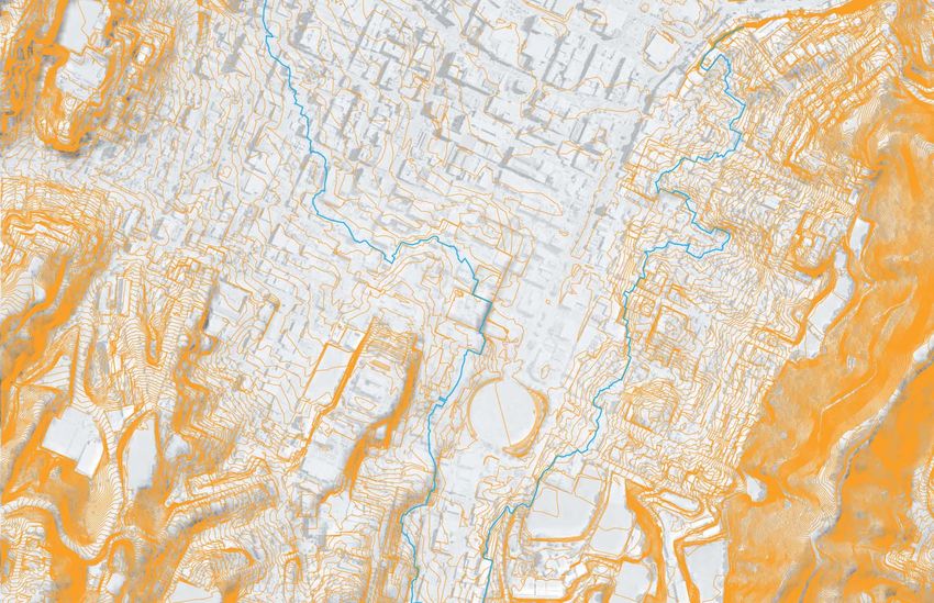
Figure 1.1: Project Area showing the proposed roading layout and land to be designated (source: NZTA)
9
4 6 10
12 13
2 3 5 8
7
11 16
14
KEY ELEMENTS
1 Vivian and Pirie Street Improvements 11 Northern Gateway Building 15 17
2 Inner City Bypass Intersection Improvements 12 Building Under the Bridge 18
(being progressed separately)
13 Proposed Reconfiguration of Regional Wines
3 Taranaki Street Improvements and Spirits Car Park
4 National War Memorial Park (by Ministry for 14 New Pohutukawa trees in the Basin Reserve
Culture & Heritage) - Under Construction
15 Ellice Street Link
5 Buckle Street Underpass - Under Construction 20
16 Proposed Reconfiguration of St Joseph’s 19
Church Car Park
6 Relocated Home of Compassion Crèche (former) 21
[undertaken as part of the NWM Park project]
17 Basin Bridge Eastern Abutment
7 Sussex Street Junction
18 Future Connection to Mount Victoria Tunnel
Dupplication (indicative)
8 Basin Bridge Western Abutment
19 Dufferin/ Rugby Street Improvements
9 Proposed Continuation of NWM Park
20 Relocated C.S. Dempster Gate
n
10 Basin Reserve Gateway
21 Adelaide Road Intersection Improvements
Figure 1.2: The Basin Bridge proposed layout - ground level Proposed designation Proposed works - permitted
wā
W RA I G H T +
A S S O C I AT E S
LANDSCAPE
ARCHITECTS
J une 2 0 1 3 P age 5
DESCRIPTION
1.6 TRANSPORT IMPROVEMENTS
Cambridge Tce
The Project proposes a grade-separated route (the bridge element) for SH1 westbound
Tory St
traffic on the northern side of the Basin Reserve. As a result, SH1 traffic will be removed
Hania St
Kent Tce
from the local road network around the eastern, southern and western sides of the Basin
Brougham St
Reserve.
The bridge soffit will be up to 7.3m above the ground surface and the top of the guard NWM Park
rail will be up to 10.5m high above the ground. The bridge is approximately 263m long or Buckle St
320m long if both abutments are included. It will be supported by six sets of piers (2 are Ellice St
double piers) and six smaller piers to support the western end of the shared pedestrian
and cycleway where it splits away from the main bridge structure. The bridge has a
Tasman
Taranaki St
minimum width of approximately 11.3m and a maximum width of approximately 16.7m. National War Memorial
There are two bridge joins, one at each end.
St
Sussex St
The Project proposes changes to the SH1 westbound route, the SH1 eastbound route,
Dufferin St
The Basin Reserve
and other roads on the network where they connect with SH1, including clearways on the Paterson St
eastern part of SH1 Vivian Street (from Tory Street to Cambridge Terrace). These propose
to improve the efficient and safe movement of traffic (including buses), pedestrians and Massey University
cyclists through intersections and provide entry and exit points for SH1. Supplementary
works on the existing local road network are also proposed to be undertaken to take
advantage of the additional capacity created by the SH1 improvements. n
Rugby St
The Project proposes new pedestrian and cycling routes throughout the Project area
as well as improvements to existing infrastructure. The majority of the works to improve Adelaide Rd
the walking and cycling routes are located on the north side of the Basin Reserve and Figure 1.3: Receiving Context - the NWM Park Project has been designed to integrate with the city as shown above. The Basin Bridge Project assumes the
connect with Mount Victoria suburb, Mount Victoria Tunnel and schools on Dufferin NWM Park will have already been built - so will form part of the receiving environment.
Street. These improvements will connect with the NWM Park which is currently under
construction and also with potential future duplication of Mount Victoria Tunnel.
Local
SH1
A reduction in State highway traffic on the roads around the Basin Reserve allows Local
Local
for more efficient northbound and southbound movements from Kent and Cambridge
Terrace to Adelaide Road. Accordingly, new dedicated bus lanes are proposed to provide
for better public transport movements around the Basin Reserve.
The key traffic flows around the Basin Reserve following the implementation of the 04
SH1
proposed Project are shown in Figure 1.4 (opposite) and described thereafter.
Local
01
The package of transportation improvements proposed by the Project are summarised KEY
below and followed by a brief description of the works: To SH1 Westbound
SH1 westbound (from Mount Victoria Tunnel to Buckle Street) To SH1 Westbound 03
To SH1 Eastbound
• The Bridge - new direct link from Paterson Street to Buckle Street via a bridge;
Local
To SH1 Eastbound
• Buckle Street three laning - provision of third lane along Buckle Street between To Cambridge Terrace SH1
Local
To Newtown
Sussex Street (including minor modifications to Sussex Street) and Taranaki To Newtown
Street to improve capacity and accommodate the two lanes from the bridge; and 02
To Newtown
01 Northen Gateway Building
• Taranaki Street improvements – modifications to the layout of Taranaki Street and
02 School drop-off
Buckle Street intersection to accommodate the three laning of Buckle Street and 03 Eastern Abutment
n
to increase capacity. 04 Western Abutment Local
Figure 1.4: Proposed Basin Bridge Project: To the west, the Basin Bridge Project is coordinated with the NWM Park to provide a high amenity landscape and
good pedestrian and cycle links between Tory Street and Cambridge Terrace. At Kent/ Cambridge a new entry plaza to the Basin Reserve is created. To the
east, the re-design of Dufferin Street offers access and servicing improvements to schools and churches in this area.
wā
W RA I G H T +
A S S O C I AT E S
LANDSCAPE
ARCHITECTS
Page 6 June 2013
1.7 URBAN DESIGN AND LANDSCAPE
SH1 eastbound (from Vivian Street – Kent Terrace - Mount Victoria Tunnel)                         Proposed urban design and landscape treatments to areas outside of the road                            built urban environment. A green screen is proposed to be located above the new
•       SH1 eastbound re-alignment - realignment of SH1 eastbound between Hania                   carriageway form part of the Project works. The development of the proposed Project                    building to provide a level of screening for the adjacent apartment building and
        Street and Brougham Street; and                                                           design has been iterative, responsive and collaborative. The Project proposes treatments               assist to visually integrate the bridge with the buildings at this corner.
                                                                                                  to areas adjacent to the road network that will assist with the integration of the proposed     •      Zone 4 Paterson/ Ellice/Dufferin Interface zone – proposes to continue ground
•       Vivian Street and Pirie Street Improvements – as part of the modifications to             bridge into the surrounding urban context.
        the intersection of Pirie Street and Kent / Cambridge Terraces and Vivian Street,                                                                                                                landscape linking from across Kent/Cambridge Terraces and additional tree
        clearways on Vivian Street are proposed. The combination of improvements                  Six zones and elements (Zones) for the Project Area have been identified within which                  planting around the Basin Reserve’s outer square.
        increases the capacity of the intersection for all traffic movements including public     character and zone specific principles for those areas have been developed to define                   The Project proposes works within St Joseph’s Church property using land
        transport.                                                                                the design intent and to provide a framework for post RMA consenting detailed design                   that is currently used for car parking. Thus, the Project proposes to remove the
                                                                                                  development.                                                                                           existing building at 28 Ellice Street and to adjust the existing car park and provide
Improvements to roads around the Basin Reserve
                                                                                                  These are briefly described for the urban and landscape zones below:                                   landscape improvements for the Church within the remaining space. All of these
•       Paterson Street / Dufferin Street intersection – layout modifications to change                                                                                                                  works are located on land owned by the Church.
        in priority at the signals including provision of a significant increase in priority to   •      Zone 1 Cambridge/Buckle Bridge Interface Zone - proposed landscape treatments
        Dufferin Street (south bound traffic from Kent Terrace/ Ellice Street);                          to land between Cambridge Terrace and the NWM Park, which includes rain                  •      Zone 5 Dufferin/Rugby Streets, Schools/Church/Government House Interface
                                                                                                         gardens and wetland plantings for stormwater treatment. This landscape area                     zone which serves as a vehicular and pedestrian access area serving key adjacent
•       Adelaide Road / Rugby Street intersection – reducing through lanes along Rugby                   has been designed as a continuation of NWM Park. The terracing in the NWM                       land uses of the schools and Government House. Proposed works include the re-
        Street from 3 lanes to 1 and allowing Adelaide Road traffic and Rugby Street                     Park starts from Kent and Cambridge Terraces and are reflective of the cultural                 allocation of space in the roading corridor, layout modification and urban design
        traffic to flow at the same time. Pedestrian and cycling crossings will be via on-               heritage of the area, as cultivation terraces. Wetland planting reflects the former             and landscape treatments.
        demand signals. Two lanes for access into Adelaide Road would remain with one                    Waitangi Lagoon which is now the Basin Reserve. The landscaping also provides
        operating as a dedicated bus lane;                                                                                                                                                        •      Zone 6 The Bridge Element – the horizontal alignment of the Bridge has retained
                                                                                                         an interface with the curtilage of the newly relocated Home of Compassion                       a close reference to the historic street pattern (the Te Aro Grid) to strengthen and
•       Ellice Street link – new road link from Ellice Street to Dufferin Street/Paterson                Crèche (former).                                                                                define the Basin Reserve ‘square’. The vertical alignment has utilised underlying
        Street intersection (a similar vehicular movement can currently be made between           •      Zone 2 Kent/Cambridge Basin Gateway: proposed landscaping between Kent/                         landform to achieve grade separation between north-south and east-west routes.
        Ellice Street and Dufferin Street). A new shared pathway for pedestrians and                     Cambridge Terrace responds to tangata whenua values in relation to the proposed                 The width of the bridge has been kept to a minimum that meets safe traffic design
        cyclists would be provided adjacent to this link to facilitate movements between                 historical wetland ecology and provides a safe and enlarged public access and                   standards for a 50km/h road. Abutments are integrated and grounded in the
        the Mount Victoria suburb, the schools on Dufferin Street, and further south                     gathering area relative to the Basin Reserve entrance. The proposed landscape                   form and material of the landscaping. Lighting on the bridge seeks to minimise
        toward Adelaide Road;                                                                            aims to facilitate gathering and includes reconfigured pedestrian crossings, bus                glare and spill onto surrounding areas and integrates with the bridge form and
•       Dufferin Street improvements – works to modify the layout of the road space and                  stops and Basin Reserve entrance.                                                               with the adjacent NWM Park. Architectural lighting is provided underneath the
        bus drop-off zones on Dufferin Street and Rugby Street on the south east corner           •      Element 2.1 Entrance to the Basin Reserve – proposes a combination of planting                  bridge and across the landscape, highlighting forms, surfaces and textures of the
        of the Basin Reserve and to improve vehicular access to Government House; and                    (pohutukawa trees) and a new Northern Gateway Building on the northern                          superstructure, under croft, piers, abutments and landscape. The combination of
•       Basin Reserve Gateway – treatment to Buckle Street where it meets Kent/                          boundary within the Basin Reserve. The combination of new Northern Gateway                      treatments and design promote the perception of the bridge being an elevated
        Cambridge Terraces, and retains an entry point to the re-aligned SH1 eastbound.                  Building and pohutukawa trees screen the bridge from general views from within                  street rather than motorway flyover.
Walking, Cycling, Public Transport (throughout the Project Area)                                         the Basin Reserve. The new Northern Gateway Building is designed to specifically         The Project will result in a number of transport benefits for the State highway network
                                                                                                         remove potential views of traffic on the bridge from the views of batsmen (facing        and the local road network (including public transport and walking and cycling) as well as
•       Walking and cycling path on bridge – new walking and cycling path on the bridge                  bowlers from the north). The new Northern Gateway Building will provide space            new buildings, structures and landscape treatments for the Basin Reserve area.
        between Paterson Street and Buckle Street / NWM Park;                                            for player facilities and includes a wider entrance for visitors to the Basin Reserve    Construction of these transportation improvements is currently scheduled to start in
•       Existing pedestrian and cycle routes – existing at-grade pathways are retained                   that is aligned with the new entrance plaza located between Kent and Cambridge           2014/15.
        or enhanced and additional and alternative routes are provided. Additional and                   Terraces.
        improved pedestrian and cycling access would be provided in the landscaped area                  The new structure will occupy the space between the R.A. Vance Stand and
        on the corner of Cambridge Terrace and Buckle Street and between Brougham                        the existing toilet block at the edge of the northern embankment. It will be             Detailed design descriptions of each zone within the Project Area are provided in
        Street and Kent Terrace. These routes link to the proposed pedestrian and cyclist                approximately 65m long and up to 12.9m high and includes a screen above the              section 6 Sector Design.
        facilities proposed through NWM Park;                                                            existing Player’s Pavilion between the new Northern Gateway Building and the
•       Public Transport - new dedicated bus lanes are proposed on Ellice Street,                        R.A. Vance Stand. This option is preferred by the Basin Reserve Trust.
        Dufferin Street and Buckle Street, and the southbound bus stop is proposed to be                 Alternative mitigation proposals including a 45m long structure and a 55m long
        relocated from Adelaide Road onto Rugby Street; and                                              structure and consequent increases in proposed tree planting have also been
•       Public Transport - existing priority for buses from Kent Terrace onto Ellice Street              considered and are outlined within this report.
        is retained.                                                                              •      Zone 3 Kent/Ellice Street corner zone – proposes a new building under the
For further detail on the proposed transport improvements refer to Volume 3: Technical                   proposed bridge at the corner of Kent Terrace and Ellice Street which will be
Report 4: Assessment of Transportation Effects of these documents. Details of the road                   made available for commercial use. It is intended to re-establish the historical built
design layouts are shown in Volume 5: Plan and Drawing Set.                                              / street edge in this location and the building helps incorporate the bridge into the

                                                                                                                                                                                                                       wā
                                                                                                                                                                                                                        W RA I G H T +
                                                                                                                                                                                                                      A S S O C I AT E S
                                                                                                                                                                                                                      LANDSCAPE
                                                                                                                                                                                                                      ARCHITECTS

J une 2 0 1 3                                                                                                                                                                                                                                                                         P age 7
CONTEXT OF THE BASIN BRIDGE PROJECT

1.8 PREVIOUS STUDIES                                                                                                                                     KEY                            1.10 ROADS OF NATIONAL SIGNIFICANCE
Over the years a number of studies have been undertaken within the study area. In                                                                                                       The 2012 Government Policy Statement (GPS) identifies 3 focus areas. These are:
2000, Meritec (now AECOM) completed a Scheme Assessment Report for the Basin                                                                                                            •      Economic growth and productivity;
Reserve. A number of options were investigated before recommending Option H as a
                                                                                                                                                                                        •      Value for money; and
preferred option. Option H provided for a two-lane flyover from Paterson Street to Buckle
Street, an underpass for vehicles using Sussex Street to reach Cambridge Terrace, and                                                                                                   •      Road safety.
an underpass for vehicles using Kent Terrace to reach Adelaide Road. The proposal                                                                                                       The 2012 GPS continues to progress the seven Roads of National Significance
provided a direct link for westbound traffic from Mount Victoria Tunnel to Buckle Street                                                                                                throughout New Zealand established in the 2009 GPS. The government identifies the
and for eastbound traffic from Kent Terrace to Mount Victoria Tunnel.                                                                                                                   continuing progress as a critical part of the economic growth and productivity priority
                                                                                                                                                                                        for the next 10 years and a significant part of the government’s National Infrastructure
                                                                                                                                                                                        Plan. One of these identified roads is the Wellington Northern Corridor Road of National
1.9 NGAURANGA TO AIRPORT CORRIDOR PLAN ΈGWRCΉ                                                                                                                                           Significance from Wellington International Airport to Levin in the north.
The Ngauranga to Airport Strategy Study 2008 investigated a range of options for
improving the transportation network within Wellington City. In terms of the Basin Reserve                                                                                              The NZTA’s strategic objectives for the Wellington Northern Corridor RoNS are:
area, relevant study recommendations were:                                                                                                                                              1.     To enhance inter-regional and national economic growth and productivity, by
•        A high quality passenger transport corridor be developed between the Railway                                                                                                          supporting a growing population and increasing freight volumes in the region;
         Station and the Hospital at Newtown, which would pass through the Basin                                                                                                        2.     To improve access to Wellington’s central business district, key industrial and
         Reserve; and                                                                                                                                                                          employment centres, port, airport and hospital;
•        Improvements to SH1 which also passes through the Basin Reserve, particularly                                                                                                  3.     To provide relief from severe congestion on the State highway and local road
         for westbound movements from Mount Victoria Tunnel to the Wellington Inner                                                                                                            networks;
         City Bypass.                                                                                                                                                                   4.     To improve the journey time reliability of travel on the section of SH1 between
The report recommended a single flyover (Option B3) to progress to Scheme                                                                                                                      Levin and Wellington Airport; and
Assessment. This option was similar to that recommended by Meritec in their 2000                                                                                                        5.     To improve the safety of travel on State highways.
Scheme Assessment Report.
                                                                                                                                                                                        The Basin Bridge Project is one of the eight sections of the Wellington Northern Corridor,
Based on the technical work completed as part of an earlier Strategy Study the Ngauranga                                                                                                as shown on Figure 1.6 (right).
to Wellington Airport Corridor Plan was developed. The Corridor Plan was adopted by
the Regional Transport Committee in October 2008.
The Corridor Plan provided a vision for the corridor that has been included in the Regional
Land Transport Strategy 2010 - 2040 as follows:
“Along the Ngauranga to Wellington Airport Corridor, access to key destinations such as
CentrePort, Wellington City CBD, Newtown Hospital and the International Airport will be
efficient, reliable, quick and easy. Priority will be given to passenger transport through
this corridor, particularly during the peak period. Passenger transport will provide a very
high quality, reliable and safe service along the Wellington City growth spine and other
key commuter routes. The road network will provide well for those trips which can not
be made by alternative modes and will allow freight to move freely through the corridor.
Traffic congestion through the corridor will be managed at levels that balance the need       Figure 1.5: WCC Urban Development Strategy (source: WCC)
for access against the ability to fully provide for peak demands due to community impacts
and cost constraints. Maximum use of the existing network will be achieved by removal         The Basin Bridge Project seeks to implement the part of the Ngauranga to Airport
of key bottlenecks on the road and rail networks.”                                            Corridor Plan (Corridor Plan), for which the NZTA is responsible- at the Basin Reserve.
The Corridor Plan has become part of the Wellington Regional Land Transport Programme
(RLTP). The RLTP details the indicative funding for Wellington’s land transport over a
period of ten years. The NZTA National Land Transport Programme (NLTP) sets out the
available funding for the Wellington Region for a period of three years. Of relevance to
the funding framework, is a priority action seeking the Corridor Plan to implement the
Basin Bridge Project within 10 years.

                                                                                                                                                                                                               wā
                                                                                                                                                                                                                W RA I G H T +
                                                                                                                                                                                                              A S S O C I AT E S
                                                                                                                                                                                                              LANDSCAPE
                                                                                                                                                                                                              ARCHITECTS

Page 8                                                                                                                                                                                                                                                                 June 2013
1.11 RELATED PROJECTS
                                                                                    The Project forms part of the Tunnel to Tunnel package of works that in combination
                                                                                    will improve traffic and transportation between the Terrace Tunnel and Mount Victoria
                                                                                    Tunnel. The Tunnel to Tunnel package also comprises:
                                                                                    •      Buckle Street Underpass as part of the NWM Park project by the Ministry for
                                                                                           Culture and Heritage. This project is currently under construction and expected to
                                                                                           be completed by the end of 2014.
                                                                                    Other NZTA studies of SH1 sections that are also being considered or are being
                                                                                    progressed concurrently within Wellington:
                                                                                    •      Duplication of Mount Victoria Tunnel (construction planned for 2017/18).
                                                                                    •      Duplication of the Terrace Tunnel (subject to feasibility investigation in 2013/14).
                                                                                    •      Roading improvements along Cobham Drive and Ruahine Streets (construction
                                                                                           planned for 2017/18).
                                                                                    While there are linkages between these projects, each one is complex and entails
                                                                                    significant use of resources. As a consequence each is being progressed separately
                                                                                    while maintaining the appropriate design standards and specifications in order to achieve
                                                                                    the NZTA’s strategic objectives for the RoNS.

                                                                                                                                                                                  Figure 1.7: Wellington RoNS Northern Corridor Plan (source: NZTA)

Figure 1.6: The eight sections of the Wellington Northern Corridor (source: NZTA)
                                                                                                                                                                                  The Wellington RoNS Northern Corridor passes through four distinct environments:
                                                                                                                                                                                  •       Kapiti Coast (the ‘Coastal’ sector)
                                                                                                                                                                                  •       Rough hill-country of the Akatarawa Ranges (the ‘Steep Country’ sector)
                                                                                                                                                                                  •       Urban motorway on approach to Wellington City (the “City Gateway’ sector)
                                                                                                                                                                                  •       Wellington City Streets (the ‘Inner City’ sector)

                                                                                                                                                                                                          wā
                                                                                                                                                                                                           W RA I G H T +
                                                                                                                                                                                                         A S S O C I AT E S
                                                                                                                                                                                                         LANDSCAPE
                                                                                                                                                                                                         ARCHITECTS

J une 2 0 1 3                                                                                                                                                                                                                                                       P age 9
DESIGN METHODOLOGY & PROCESS

1.12 DESIGN LED INTERͳDISCIPLINARY PROJECT TEAM:                                          URBAN DESIGN PROCESS:                                                                          REFINEMENT OF TRANSPORT SOLUTIONS:
While the urban design component for the Basin Bridge Project has been led by a team      The urban design process led by Wraight Athfield Landscape and Architecture (WALA)             The Project Team investigated a range of transport proposals within the Basin Bridge
of Urban Design, Landscape Architectural and Architectural specialists, the design        has involved the following phases of input.                                                    Project Area including at-grade, grade separated and underground options. The design
directions summarised in the ULDF incorporate and reconcile specialist inputs from a                                                                                                     of these were developed to an outline level by the team and assessed using the criteria
broad multi-disciplinary team covering the fields of Transportation, Traffic, Planning,                                                                                                  established in the scoping report. Two options were selected for public engagement
Social, Cultural, Heritage, Archaeology, Ecology, Civil, Geotech, Economic, and Crime     URBAN DESIGN SCOPING:                                                                          (2011).
Prevention Through Environmental Design (CPTED).                                          Urban design issues and opportunities within the Basin Bridge Project Area were
                                                                                          identified. This was informed by: site visits and observation; photographic survey;
                                                                                          mapping of the bio-physical context; a review of historical context; and consultation with     PUBLIC ENGAGEMENT:
1.13 ITERATIVE AND RESPONSIVE DESIGN PROCESS:                                             experts including stakeholder discussions.                                                     The options were developed to a level of detail which conveyed the design intent and the
The design process has been iterative and responsive. The design directions have been     Through analysis of the Project Area and appropriate cognisance of the New Zealand             community was invited to provide feedback on their design preference and any priorities
informed by:                                                                              Urban Design Protocol, a set of principles and criteria were developed which provided a        for further development.
•     Consideration and assessment of relevant statutory and non-statutory documents;     platform for consideration of issues and opportunities.
•     Detailed Urban Design assessment of the existing receiving context at city wide                                                                                                    DESIGN DEVELOPMENT:
      and project area scales;                                                            DESIGN PRINCIPLES AND CONCEPT DESIGN:                                                          Feedback from public engagement was used to inform further development of the
                                                                                          Initial Project Principles for the Inner City Sector were developed through analysis of        preferred design. Specific design refinements included changes to bridge design and
•     Consideration of other relevant specialist assessments;
                                                                                          the site and context carried out in the urban design scoping phase (Refer WALA RT04,           the articulation and mitigation of a range of effects through landscape design to new
•     Consideration and assessment of Urban Design Principles for the Wellington                                                                                                         built form.
                                                                                          Appendix 3.B). While these principles were informed by the 7’C’s of NZUDP, they were
      RoNS Northern Corridor, the Inner City Sector, as well as principles developed
                                                                                          further developed to cover the range of specific urban design issues relevant to this site,    The proposed developed design has also been informed by the NZ Building Code, NZTA
      in consultation with the NZTA and WCC to cover the specific conditions of this
                                                                                          and to provide a workable framework for both assessment and design development                 guidelines and the WCC Policies, Strategies and Guidelines listed in Section 2.
      project area; and
                                                                                          of options. Through the process these principles were reviewed by urban design
•     Consideration of issues and recommendations raised in consultation with key         representatives of both the NZTA and WCC to ensure they sat appropriately between
      stakeholders, including: Wellington City Council (WCC); neighbours; and             both the NZTA broader Urban Design Policy, and were also inclusive of Inner City Sector
      organisations associated with adjacent properties; and the wider community          aspects. These principles were used, along with a set of criteria, to assess urban design
      through the Community Engagement process.                                           effects of options developed. This methodology for developing design and assessment
The statutory and non-statutory documents that have particularly informed the urban       aimed to provide a mechanism to consider effects of options in terms of positive or
design of this Project are outlined in Section 2.                                         enabling urban design effects, rather than just focussing on aspects of mitigation of
                                                                                          negative effects or damage control.
The process of scoping, option identification, assessment and design development has
been led by Opus International. This process included a number of Design by Enquiry       These Inner City Sector Principles then informed the Corridor-wide Urban Design
Workshops where input from all the specialists was tabled and reviewed by the broader     Principles. However, as these corridor-wide principles relate to the regional scale, for
Project team. Stakeholders from WCC, MCH and NZHPT were extensively consulted             the development of design solutions for this project site, the Inner City Sector Principles
throughout.                                                                               have remained the primary urban design development and assessment tool across the
                                                                                          Project.
                                                                                          For the finer grain development of specific components and elements within each
                                                                                          ‘Project’ zone, a further localised set of zone specific principles has been developed.
                                                                                          These are informed by, and can be referenced back to the Inner City Sector Principles.
                                                                                          The three tiers of principles therefore relate to three different scales of context:
                                                                                          •      The regional scale is guided by the Corridor-Wide Urban Design Principles;
                                                                                          •      The project area scale is guided by the Project Principles for the Inner City Sector;
                                                                                                 and
                                                                                          •      The landscape zones within the Project Area are guided by the Zone Specific
                                                                                                 Principles.
                                                                                          These three sets of urban design principles are detailed in Section 5 Corridor Design
                                                                                          Principles. In our opinion these principles and the approach developed are professionally
                                                                                          appropriate to these circumstances

                                                                                                                                                                                                              wā
                                                                                                                                                                                                               W RA I G H T +
                                                                                                                                                                                                             A S S O C I AT E S
                                                                                                                                                                                                             LANDSCAPE
                                                                                                                                                                                                             ARCHITECTS

Page 10                                                                                                                                                                                                                                                               June 2013
2 POLICY CONTEXT
This section summarises the statutory and non-statutory policy context for the Basin • S15 Discharge of contaminants into environment; and 2.1.4 GREATER WELLINGTON REGIONAL POLICY STATEMENT
Bridge Project. For each policy document a short description of its purpose is provided • S17 Duty to avoid, remedy, or mitigate adverse effects. The RPS identifies the regionally significant issues around the management of the
and some of the key relevant sections and policies relevant to the urban design Region’s natural and physical resources, and sets out what the Greater Wellington
consideration of the Basin Bridge Project are identified. A separate full report on the Regional Council is seeking to achieve (objectives) and the way in which they will seek
statutory provisions of the Basin Bridge Project has been prepared by others. (Refer 2.1.2 LAND TRANSPORT MANAGEMENT ACT 2003 to achieve those objectives (policies and methods).
Volume 2: AEE and Volume 3: Technical Report 18 - Statutory Provisions Report). The Land Transport Management Act (LTMA) establishes the NZTA. Under s94 of the The objectives, policies and methods of the RPS are required to be given effect to, within
The NZTA Urban Design professional services guide identifies urban design as a LTMA, the objective of the NZTA is ‘to undertake its functions in a way that contributes the regional and district plans of the Wellington region.
multidisciplinary approach to achieving quality of life for communities. Urban design for to an affordable, integrated, safe, responsive, and sustainable land transport system.’
The Regional Land Transport Strategy (RLTS) and the local authority District Plans are
highways concerns the response to place and contribution to the physical form, function Section 96 of the LTMA sets out operating principles that the NZTA must adhere to in required not to be inconsistent with the RPS. Its key policies include those promoting
and visual quality of the regions through which they pass and serve. meeting its objective and undertaking its functions. These operating principles include travel demand management mechanisms that reduce the use and consumption of non-
As well as achieving its transport objectives in moving people and goods, the State ‘exhibiting a sense of social and environmental responsibility, which includes ‘avoiding, renewable transport fuels and carbon dioxide emissions from transportation.
highway network should contribute to the form of human settlements and their to the extent reasonable in the circumstances, adverse effects on the environment’
(s96(1)(a)(i)). Travel demand management includes a range of mechanisms - such as travel behavioural
accessibility. The State highway should integrate into the place through which it passes, change programmes, road pricing tools and improvements to the efficiency of the existing
with the associated landform, urban form, have regard for the natural ecology as well as In furtherance of this principle, NZTA has adopted an Environmental Plan, which guides network. It is also important to ensure good connectivity within and between settlements
the built, natural and cultural heritage. the Highways and Network Operations Group, and an action plan for the New Zealand to optimise walking, cycling and public transport.
Urban Design Protocol, to which the NZTA is a signatory.
The RPS acknowledges the risks of poor urban design as having the capacity to
2.1 STATUTORY DOCUMENTS OF PARTICULAR RELEVANCE adversely affect public health, social equity, land values, the vibrancy of local centres
2.1.3 HISTORIC PLACES ACT 1993 and economies, and the provision of, and access to, civic services.
TO THE URBAN DESIGN OF THIS PROJECT
S4 of the Act states the purpose of the Act is to promote the identification, protection, When considering an application for a resource consent, notice of requirement, or a
preservation, and conservation of the historical and cultural heritage of New Zealand. change, variation or replacement of a district or regional plan, particular regard shall be
2.1.1 RESOURCE MANAGEMENT ACT 1991 In achieving this, all persons exercising functions and powers under it shall recognise:
The Resource Management Act (RMA) is intended to promote the sustainable given to achieving the region’s urban design principles. These principles are based on
management of natural and physical resources. a) The principle that historic places have lasting value in their own right and provide the “seven C’s” of the New Zealand Urban Design Protocol (NZ UDP).
evidence of the origins of New Zealand’s distinct society; and The broad to detailed principles for the Project have been developed having regard to
Under the Act, sustainable management means managing the use, development, and
protection of natural and physical resources in a way, or at a rate, which enables people b) The principle that the identification, protection, preservation, and conservation of the NZ UDP and RPS. In particular Section 3 with regard to ‘Regional form, design and
and communities to provide for their social, economic, and cultural well-being and for New Zealand’s historical and cultural heritage should: function’.
their health and safety while: i) Take account of all relevant cultural values, knowledge, and disciplines;
a) Sustaining the potential of natural and physical resources (excluding minerals) to ii) Take account of material of cultural heritage value and involve the least possible 2.1.5 WELLINGTON REGIONAL LAND TRANSPORT STRATEGY 2010ͳ40
meet the reasonably foreseeable needs of future generations; and alteration or loss of it; ΈRLTSΉ
b) Safeguarding the life-supporting capacity of air, water, soil, and ecosystems; and iii) Safeguard the options of present and future generations; The vision of the Regional Land Transport Strategy is to “deliver an integrated land
transport network, supporting the region’s people and prosperity in a way that is
c) Avoiding, remedying, or mitigating any adverse effects of activities on the iv) Be fully researched, documented, and recorded, where culturally appropriate;
economically, environmentally and socially sustainable.” (p ii)
environment and traditions with their ancestral lands, water, sites, wahi tapu, and and
other taonga. The RLTS objectives are to:
c) The relationship of Maori and their culture and traditions with their ancestral lands,
Relevant sections of the RMA to the Urban Design of the Basin Bridge Project include, water, sites, wahi tapu, and other taonga. • Assist economic and regional development;
but are not limited to: • Assist safety and personal security;
• S5 the purpose of the Act is to promote the sustainable management of natural URBAN DESIGN IMPLICATIONS • Improve access, mobility and reliability;
and physical resources; The Basin Bridge Project is located within an area of historic importance to Wellington • Protect and promote public health;
• S6(e) the relationship of Maori and their culture and traditions with their ancestral and New Zealand. Important historic elements include the Te Aro grid, National War
• Ensure environmental sustainability; and
lands, water sites, wahi tapu and other taonga; Memorial and Carillon, former National Museum, the former Mount Cook Police Station
and retaining wall, the former Home of Compassion Crèche, the Basin Reserve, • Ensure that the Regional Land Transport Programme is affordable for the regional
• S6(f) the protection of historic heritage from inappropriate subdivision, use and
Government House, and potential archaeological sites adjacent to Buckle Street, Kent community.
development;
and Cambridge Terraces, and Dufferin Street. RLTS (2010) p 27
• S7 (c) the maintenance and enhancement of amenity values;
The strategy recognises that increasing population and economic growth within the
• S7 (d) the intrinsic values of ecosystems;
Region is likely to lead to increased demand for travel. The strategy indicates that the
• S7 (f) the maintenance and enhancement of the quality of the environment; Region’s population are making more trips, more often.
• S8 Treaty of Waitangi;
wā
W RA I G H T +
A S S O C I AT E S
LANDSCAPE
ARCHITECTS
J une 2 0 1 3 P age 112.1.6 WELLINGTON CITY DISTRICT PLAN 2000 • Maintain the built form and scale of achieve appropriate building height and mass 12.2.7.1 Promote a sustainable built environment in the Central Area, involving the
The Wellington City Council District Plan (DP) is the primary document that manages within identified heritage and character areas. efficient end use of energy and other natural and physical resources and the use of
land use and development within Wellington City. 12.2.5.3 Manage building mass in conjunction with building height to ensure quality renewable energy, especially in the design and use of new buildings and structures.
The DP identifies key qualities and values including one of promoting an accessible design outcomes. 12.2.7.2 Ensure all new buildings provide appropriate levels of natural light to occupied
city. An accessible city is one in which people can achieve access to destinations which 12.2.5.10 Provide for consideration of ‘permitted baseline’ scenarios relating to building spaces within the building.
enable them to meet their needs. In an accessible city, transport and land-use planning height and building bulk when considering the effect of new building work on the amenity 12.2.13 To avoid or mitigate the adverse effects of natural and technological hazards on
are integrated to enhance accessibility for all people while minimising the adverse effects of other Central Area properties. people, property and the environment.
of transport on quality of life and the environment.
12.2.6 To ensure that new building works maintain and enhance the amenity and safety 12.2.13.3 Ensure that the adverse effects of hazards on critical facilities and lifelines are
The Basin Bridge Project passes through a mix of District Plan Areas. These include of the public environment in the Central Area, and the general amenity of any nearby avoided, remedied or mitigated.
Inner Residential, Open Space A and Central Area, and borders an institutional precinct, Residential Areas. 12.2.15 To enable efficient, convenient and safe access for people and goods within the
and suburban centre. Objectives and policies with relevance to the urban design for the
12.2.6.2 Require high quality building design within the Central Area that acknowledges, Central Area.
Basin Bridge Project are outlined in the following sections. These objectives and policies
and responds to, the context of the site and the surrounding environment. 12.2.15.1 Seek to improve access for all people, particularly people travelling by public
have informed the Urban Design outcomes in the proposed design.
12.2.6.3 Ensure that new buildings and structures do not compromise the context, transport, cycle or foot, and for people with mobility restrictions.
setting and streetscape value of adjacent listed heritage items, through the management 12.2.15.3 Manage the road system in accordance with a defined road hierarchy.
CENTRAL AREA of building bulk and building height.
12.2.1 To enhance the Central Area’s natural containment, accessibility, and highly 12.2.15.8 Manage on-site parking to ensure any adverse effects on the surrounding
12.2.6.4 Protect sunlight access to identified public spaces within the Central Area and street network are avoided, remedied or mitigated.
urbanised environment by promoting the efficient use and development of natural and
ensure new building developments minimise overshadowing of identified public spaces
physical resources. 12.2.15.9 Require the provision of servicing or loading facilities for each site in the
during periods of high use.
12.2.2 To facilitate a vibrant, dynamic Central Area by allowing a wide range of activities Central Area.
12.2.6.5 Advocate for new building work to be designed in a way that minimises
to occur, provided that adverse effects are avoided, remedied or mitigated. 12.2.15.10 Ensure that the design and location of servicing or loading facilities is
overshadowing of any public open space of prominence or where people regularly
12.2.2.1 Encourage a wide range of activities within the Central Area by allowing most congregate. appropriate having regard to the nature of the development and the existing or likely
uses or activities provided that the standards specified in the Plan are satisfied. future use of the site.
12.2.6.7 Protect, and where possible enhance, identified public views of the harbour, hills
12.2.2.3 To provide for temporary activities that contribute to the social, economic and townscape features from within and around the Central Area. 12.2.15.12 Manage the creation of new vehicle accessways along identified roads in the
and cultural wellbeing of the community, and control the adverse effects of temporary Central Area, to ensure:
12.2.6.11 Enhance the informal pedestrian network within the Central Area, by
activities in a manner that acknowledges their infrequent nature and limited duration. • Efficient, convenient and safe movement of pedestrians, vehicles and public
encouraging the retention and enhancement of existing pedestrian thoroughfares, and
12.2.2.4 Control the adverse effects of noise in the Central Area. promoting the creation of new thoroughfares where they would enhance walkability and transport; and
12.2.3 To recognise and enhance those characteristics, features and areas of the Central permeability for pedestrians. • Continuity of key commercial frontages.
Area that contribute positively to the City’s distinctive physical character and sense of 12.2.6.12 Maintain and enhance the visual quality and design of ground floor level 12.2.15.14 Protect and enhance access to public spaces in the Central Area.
place. developments fronting onto streets, parks and pedestrian thoroughfares throughout the 12.2.16 To facilitate and enable the exercise of tino rangatiratanga and kaitiakitanga by
12.2.3.1 Preserve the present ‘high city/low city’ general urban form of the Central Area. Central Area. Wellington’s tangata whenua and other Maori.
12.2.3.2 Promote a strong sense of place and identity within different parts of the Central 12.2.6.15 Improve the design of developments to reduce the actual and potential threats 12.2.16.1 Identify, define and protect sites and precincts of significance to tangata
Area. to personal safety and security. whenua and other Maori using methods acceptable to tangata whenua and other Maori.
12.2.4 To ensure that any future development of large land holdings within the Central 12.2.6.16 Promote and protect the health and safety of the community in development 12.2.16.2 Enable a wide range of activities that relate to the needs and wishes of tangata
Area is undertaken in a manner that is compatible with, and enhances the contained proposals. whenua and other Maori, provided that physical and environmental standards specified
urban form of the Central Area. 12.2.6.17 Ensure that public spaces in the Central Area (including privately owned places in the Plan are met.
12.2.4.5 Ensure that development within the Te Aro Corridor assists to integrate the Inner that are characterised by public patterns of use) are suitably lit at night time to improve
City Bypass in to the urban fabric of southern Te Aro. the safety and security of people.
OPEN SPACE
12.2.5 Encourage the development of new buildings within the Central Area provided 12.2.6.18 Maintain and enhance the streetscape by controlling the siting and design of Under the DP, the Basin Reserve, and median strips along Kent and Cambridge Terraces
that any potential adverse effects can be avoided, remedied or mitigated. structures on or over roads and through continuing programmes of street improvements. are Open Space A. Open Space A land provides passive and active recreational
12.2.5.1 Manage building height in the Central Area in order to: 12.2.6.19 Maintain and enhance the streetscape by controlling the creation of vacant or opportunities. The primary focus is the need for recreation activities to be able to access
open land and ground level parking areas. open space areas. Relevant objectives for Open Space include:
• Reinforce the high city/low city urban form;
12.2.6.20 Require that where Central Area buildings or structures adjoin a Residential 16.5.1 To maintain, protect and enhance the open spaces of Wellington City.
• Ensure that new buildings acknowledge and respect the form and scale of the
Area, they satisfy additional standards. 16.5.1.1 Identify a range of open spaces and maintain their character, purpose and
neighbourhood in which they are located; and
12.2.7 To promote energy efficiency and environmental sustainability in new building function, while enhancing their accessibility and usability.
design.
wā
W RA I G H T +
A S S O C I AT E S
LANDSCAPE
ARCHITECTS
Page 12 June 2013You can also read