Bushfire Management Plan - Roches Beach Coastal Reserve and Nowra Bushland Reserve Roches Beach - Clarence City Council
←
→
Page content transcription
If your browser does not render page correctly, please read the page content below
Clarence City Council

Bushfire Management Plan

Roches Beach Coastal Reserve
and Nowra Bushland Reserve
Roches Beach

                                      Revised
                               January 2017
                        Clarence City Council
Contents
                                                                                                                                              Page

1.   Introduction ............................................................................................ 1
      1.1     Aim…………….. ............................................................................................ 1
      1.2     Location and Description ............................................................................. 1
                1.2.1     Geology and Soils ................................................................................................. 3
                1.2.2     Vegetation .............................................................................................................. 3
                1.2.3     Reserve Usage ....................................................................................................... 3

      1.3     Bushfire Management Objectives ............................................................... 5
      1.4     Reserve Management Responsibilities ....................................................... 5
2.   Bushfire Risks ........................................................................................ 6
      2.1     Fire History and Causes ............................................................................... 6
                2.1.1     Bushfires ................................................................................................................. 6
                2.1.2     Planned Burning ................................................................................................... 6

      2.2     Fuel Types and Hazard Levels .................................................................. 10
      2.3     Bushfire Threat and Risk to Persons......................................................... 13
      2.4     Assets at Risk from Bushfire ...................................................................... 13
                2.4.1     Bushfire Risk to Natural Heritage Assets .........................................................16
                2.4.2     Bushfire and Habitat Management ...................................................................21
                2.4.3     Bushfire Risk to Built and Cultural Assets .......................................................25

3.   Bushfire Management Issues............................................................ 29
      3.1     Existing Bushfire Management ................................................................. 29
                3.1.1     Implementation of the Previous Bushfire Management Plan ........................29
                3.1.2     Planned Burning ..................................................................................................29
                3.1.3     Vehicle Access Routes and Foot Tracks ............................................................29
                3.1.4     Water Supply ........................................................................................................33
                3.1.5     Fuel Breaks and Defendable Spaces ..................................................................33
                3.1.6     Bushfire Detection and Suppression .................................................................35

      3.2     Weeds……. ................................................................................................... 35
      3.3     Stakeholder and Community Concerns ................................................... 36
4.   Plan Implementation .......................................................................... 37
      4.1     Bushfire Risk Reduction Strategy ............................................................. 37
      4.2     Community Education, Awareness and Involvement .......................... 37
      4.3     Planned Burning .......................................................................................... 38
                4.3.1     Vegetation Management Units (VMU) .............................................................38
                4.3.2     Planned Fire Regimes ..........................................................................................38
4.3.3      Preparation and Supervision ..............................................................................42

           4.4      Bushland Management ............................................................................... 42
5.       Bushfire Management Recommendations ..................................... 44
           5.1      Management Action Summary ................................................................. 45

 References

Appendix A – Implementation of the previous bushfire management plan
Appendix B – Summary of community concerns and comments in the initial
                                round of community consultation

                                                             FIGURES
                                                                                                                                          Page

FIGURE 1 – LOCATION OF THE RESERVES ......................................................................................................... 2

FIGURE 2 – VEGETATION TYPES IN THE RESERVES ........................................................................................... 4

FIGURE 3 – RESERVE BUSHFIRE HISTORY ......................................................................................................... 8

FIGURE 4 – RESERVE PLANNED BURN HISTORY .............................................................................................. 9

FIGURE 5 @ ASSETS AT RISK FROM BUSHFIRE ...................................................................................................15

FIGURE 6 – VEHICLE AND FOOT ACCESS.........................................................................................................30

FIGURE 7 – VEGETATION MANAGEMENT UNITS IN THE RESERVES ...............................................................39

                                                              TABLES
                                                                                                                                          Page

TABLE 1 – CHARACTERISTICS OF THE DIFFERENT FUEL TYPES IN THE RESERVES ............................................12

TABLE 2 – CONSERVATION VALUE OF NATIVE PLANT COMMUNITIES ............................................................17

TABLE 3 @ PLANT SPECIES OF CONSERVATION VALUE AND PREFERRED BUSHFIRE MANAGEMENT ...............18

TABLE 4 @ FAUNA OF CONSERVATION VALUE AND PREFERRED BUSHFIRE MANAGEMENT ............................19

TABLE 5 – FIRE ATTRIBUTES OF THE NATIVE VEGETATION..............................................................................20

TABLE 6 @ BUSHFIRE MANAGEMENT REQUIREMENTS OF THE PLANT COMMUNITIES IN THE RESERVES .........23

TABLE 7 @ BUSHFIRE RISK ASSESSMENT FOR BUILT AND CULTURAL ASSETS....................................................27

TABLE 8 @ CONDITION AND MAINTENANCE OF FIRE TRAILS IN THE RESERVES...............................................31

TABLE 9 – BUSHFIRE MANAGEMENT IN THE RESERVES ...................................................................................40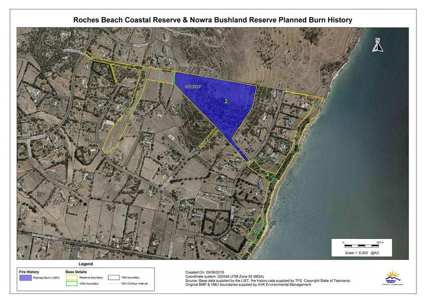
PROJECT TEAM
Rob Whittle    @ Clarence City Council @ Fire and Bushland Vegetation
                  Management Works Officer
Pat Marshall   @ Clarence City Council – Fire and Bushland Vegetation
                  Management Coordinator
Gregg Jack     @ Clarence City Council – Systems Asset Officer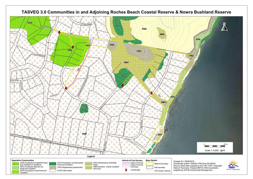
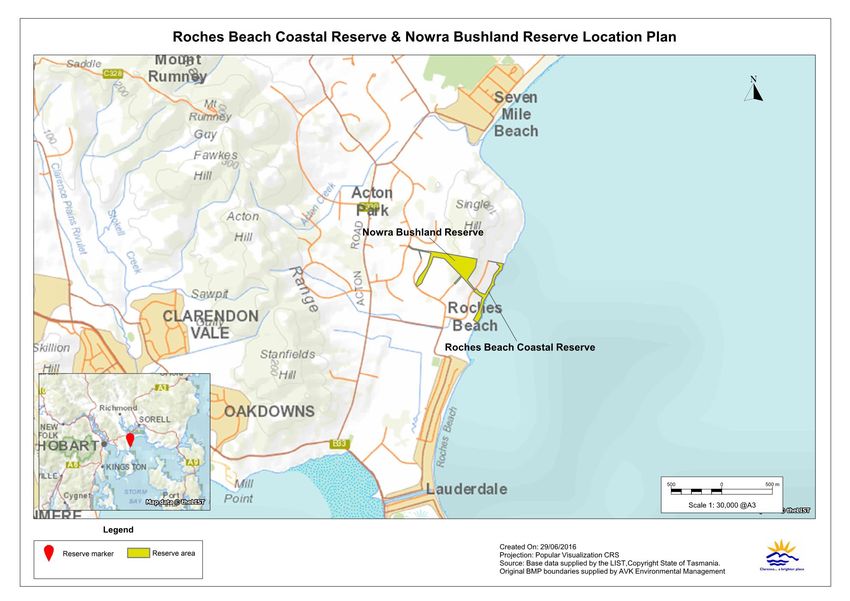
Roches Beach Coastal Reserve and Nowra Bushland Reserve Bushfire Management Plan      Revision 2, January 2017

1.         Introduction
This Bushfire Management Plan (BMP) is the second revision and expansion of the BMP for Roches
Beach Coastal Reserve and Nowra Bushland Reserve (formerly Kirra Road Bushland Reserve)
prepared by AVK Environmental Management and Renaissance Forestry in 2005, and will operate
for a period of 5 years after which another review is recommended.

It should be noted that this BMP is not an operations plan and does not deal directly with
“response” to bushfires. Operational procedures are dealt with in various documents prepared by
the Tasmania Fire Service (TFS) and other emergency services.

1.1            Aim
The aim of this BMP is to provide a framework for bushfire management that meets Clarence City
Council’s land management objectives for the site, as set out in Council’s Bushfire Management
Strategy for Council Owned and Controlled Land, Bushfire Management Strategy $ Best Management
Practice Guidelines and Strategic Plan.

It must be noted that it will not be possible to prevent bushfires occurring in the reserves. Unless
these fires are suppressed quickly, there is a risk that large destructive fires may develop.
Depending on weather conditions, such fires may burn a substantial portion of the bushland in
and adjoining the reserves causing damage to assets and environmental values, and even loss of
life. This BMP aims to lessen these risks by minimising the risk of fires starting in the reserves, and
minimising the risk of injury or damage to assets in and surrounding the reserves.

This plan also provides for the use of fire as a management tool to:

•    Target area for maximum risk reduction

•    reduce bushfire hazard to protect assets from bushfires

•    maintain the long@term viability of the native vegetation in the reserves

•    Assist in the removal of weeds and the regeneration of degraded bushland.

1.2            Location and Description
The area covered by this BMP includes the Roches Beach Coastal Reserve of approximately 6ha and
the Nowra Bushland Reserve of approximately 16.3ha (see figure 1). The Roches Beach Coastal
Reserve is a narrow coastal strip between private property on the eastern side of Kirra Road and
Fredrick Henry Bay. Nowra Bushland Reserve is situated on the southern slopes of Single Hill on
the western side of Kirra Road (see figure 1). The highest point in the reserves is approximately
130m above sea level. Both reserves have multiple entry points (see figure 6).

Sections of both reserves have been mapped as a bushfire@prone area under the Clarence Interim
Planning Scheme 2015. Any future developments within or adjacent may require a Bushfire Risk
Assessment and a Bushfire Hazard Management Plan.

Clarence City Council                                                                                       1
Roches Beach Coastal Reserve and Nowra Bushland Reserve Bushfire Management Plan   Revision 2, January 2017

Figure 1 – Location of the Reserves

Clarence City Council                                                                          2
Roches Beach Coastal Reserve and Nowra Bushland Reserve Bushfire Management Plan     Revision 2, January 2017

1.2.1        Geology and Soils
The coastal reserve consists of a very narrow, low foredune in the south and low dolerite cliffs and
steep slopes to the north. Soils are thin podzolics, prone to tunnel erosion in gullies. The higher
Nowra Bushland Reserve is on Jurassic dolerite. Soils here are brown clays of medium to high
plasticity that are subject to cracking in dry periods.

1.2.2        Vegetation
The major vegetation communities in the reserves are shown in figure 2. Vegetation types and
community boundaries within the reserves are based on TASVEG 3.0 mapping, checked and
modified where required following a survey of the reserves. Vegetation community boundaries
outside the reserves have not been checked for accuracy but are shown to give an indication of the
surrounding vegetation. Both reserves contain areas of managed grassland that is periodically
slashed as well as former areas of pasture that are slowly returning to native bushland. The main
native vegetation communities in the reserves are Eucalyptus globulus dry forest and woodland
(DGL) in the coastal reserve and Bursaria$Acacia woodland and scrub (NBA) in Nowra Bushland
Reserve. There are also small areas of Allocasuarina verticillata forest (NAV) in the coastal reserve,
Eucalyptus amygdalina forest and woodland on sandstone (DAS), Eucalyptus viminalis grassy forest
and woodland (DVG) and Eucalyptus ovata forest and woodland (DOV) in Nowra Bushland
Reserve.

Eucalyptus amygdalina forest and woodland on sandstone (DAS), Eucalyptus globulus dry forest and
woodland (DGL) and Eucalyptus ovata forest and woodland (DOV) are listed as threatened native
vegetation communities under the Nature Conservation Act 2002.

1.2.3        Reserve Usage
The Roaches Beach Coastal Reserve contains a popular walking track through to Seven Mile Beach;
Nowra Bushland Reserve has a highly frequented informal mountain bike track. Both reserves are
used for activities such as; walking, bike riding, dog exercising and jogging.

Clarence City Council                                                                                      3
Roches Beach Coastal Reserve and Nowra Bushland Reserve Bushfire Management Plan   Revision 2, January 2017

Figure 2 – Vegetation Types in the Reserves

Clarence City Council                                                                          4
Roches Beach Coastal Reserve and Nowra Bushland Reserve Bushfire Management Plan Revision 2, January 2017
1.3 Bushfire Management Objectives
Bushfire management within the Roches Beach Coastal Reserve and Nowra Bushland Reserve will
meet the following broad management objectives:
1. Protection of life, assets and adjoining property from bushfire.
2. Minimise the risk of fires starting and spreading in the reserve.
3. Protection and enhancement of the ecological and visual values provided by the reserve.
4. Protection of infrastructure and cultural heritage values within the reserve.
5. Recovery, maintenance and enhancement of vegetation communities and fauna habitat within
the reserve.
6. Minimisation of soil loss resulting from bushfire, or bushfire management activities.
The actions recommended to attain each of these objectives are listed in section 5.1.
1.4 Reserve Management Responsibilities
Management of the reserves is the responsibility of the Clarence City Council. Clarence City
Council has a responsibility under the Fire Service Act (1979) to take all reasonable precautions to
prevent any fire lit on their property from spreading onto neighbouring property. This BMP will
help to fulfil that “duty of care”. The TFS is responsible for suppressing bushfires within the
reserves.
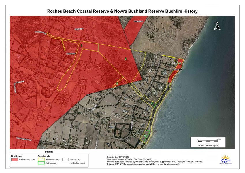
Clarence City Council 5Roches Beach Coastal Reserve and Nowra Bushland Reserve Bushfire Management Plan Revision 2, January 2017 2. Bushfire Risks Extreme bushfire conditions can occur in southern Tasmania when dry winters and springs are followed by summers where fuels are very dry. Under these conditions, fires can be expected to move quickly under the influence of strong, dry, north@westerly winds, and then move more or less at right angles on a broad front when the subsequent south@westerly wind change arrives. Fires that start under these conditions can reach a very high intensity, even in areas with relatively low fuel loads, and are very difficult to control until the weather conditions abate. 2.1 Fire History and Causes The bushfire history of both reserves is shown on figure 3. The planned burn history of both reserves is shown on figure 4. 2.1.1 Bushfires Approximately 14ha of Nowra Bushland Reserve was impacted by the 1967 black Tuesday bushfires. In February 2013, 0.3ha of Nowra Bushland Reserve was impacted by a bushfire ignited by the mower being used to reduce the fuel load on the adjacent private property catching on fire. This fire burnt in total approximately 17ha into the adjacent Single Hill, suppression was achieved via helicopters water bombing. In December 1999 the northern end of Roches Beach Coastal Reserve was impacted by a small vegetation fire approximately 1.3ha. The cause was determined as unknown. During the five year period of the previous BMP the TFS attended only one incident within both reserves – the February 2013 bushfire in Nowra Bushland Reserve. 2.1.2 Planne d Burning No planned burning for asset protection or ecological purposes was scheduled for the duration of the previous BMP. The only documented planned burn occurred within Nowra Bushland Reserve in vegetation management unit (VMU) 4 (see figure 7) during 1997. The previous regime excluding fire in both reserves will continue for the five year duration of this BMP, and should be revised at the next BMP review. This review should analyse the requirement of a planned burning regime in the NBA and FRG communities (see figure 2) within Nowra Bushland Reserve to encourage native grass species recruitment. Section 2.4.2, 3.2 and 4.3.2 outlines serrated tussock (Nassella trichotoma) restraints that need to be factored in at time of review. It also must be noted that fuel reduction burning in grasslands has little effect, as grass fuels can be replenished within a year post burn. Clarence City Council 6
Roches Beach Coastal Reserve and Nowra Bushland Reserve Bushfire Management Plan   Revision 2, January 2017

Broadscale planned burning is to be excluded from future BMPs within Roches Beach Coastal
Reserve to mitigate coastal erosion. If required, patch or pile burning should only be utilised by
those who satisfy the training requirements in section 4.3.3. Any patch or pile burning is solely at
the discretion of Councils Fire and Bushland Management Co@ordinator, and no heaping of
vegetation to be burned shall occur prior to consultation.

Clarence City Council                                                                                    7
Roches Beach Coastal Reserve and Nowra Bushland Reserve Bushfire Management Plan   Revision 2, January 2017

Figure 3 – Reserve Bushfire History

Clarence City Council                                                                          8
Roches Beach Coastal Reserve and Nowra Bushland Reserve Bushfire Management Plan   Revision 2, January 2017

Figure 4 – Reserve Planned Burn History

Clarence City Council                                                                          9
Roches Beach Coastal Reserve and Nowra Bushland Reserve Bushfire Management Plan                Revision 2, January 2017

2.2            Fuel Types and Hazard Levels
The higher the intensity of a bushfire the greater its destructiveness and the more difficult it is to
control. As the intensity of a bushfire increases it becomes progressively more difficult to contain
and suppress the bushfire. Very high intensity (> 4000 kW/m heat output at the fire front) fires
with flame heights greater than 10m are generally uncontrollable (NSW Rural Fire Service, 1997).
Although grass fires rarely attain a very high intensity, they can move much faster than forest fires,
thereby making them difficult to contain.

Bushfire intensity is a function of the heat content of the fuel, the quantity (load) of fuel, and the
rate of spread of the bushfire. The heat content of vegetation fuels is roughly constant, and rate of
spread is largely a function of slope and weather conditions (wind speed and relative humidity). It
has been found that the quantity and distribution of fine fuels are the main factor influencing
bushfire behaviour. Larger fuels burn during a bushfire but do not contribute significantly to the
spread of a bushfire (NSW Rural Fire Service, 1997).

Fine fuels consist of dead plant matter less than 6mm in diameter and live plant matter less than
2mm in diameter (including grasses, bracken, leaves, bark, and twigs and branches) (Marsden@
Smedley, 2009). Fine fuel load (measured in tonnes per hectare) has therefore been used as a
convenient measure of the underlying bushfire hazard in areas dominated by woody vegetation.
The fine fuel load at any given time is a balance between the rate of fuel build@up, and factors that
remove fuel, such as litter decomposition and fire. In the absence of bushfire, fuel loads in forests
and woodlands with a shrubby or heathy understorey build up to a quasi@equilibrium state where
the rate of fuel production equals the rate of decomposition.                      The maximum levels vary for
different vegetation types and also for the same vegetation types in different locations (Conroy,
1988). The time taken to reach equilibrium fuel loads also varies, ranging from about 2 years in
some native grasslands to about 20 to 40 years in dry eucalypt forests (Marsden@Smedley, 2009).

However, it has been found that the fuel structure is possibly more important than the total fine
fuel load in determining bushfire behaviour (Marden@Smedley, 2009). Fuel in forests, woodlands
and shrublands can be categorised into four layers with differing effects on bushfire behaviour
(Hines et al., 2010). These layers are:

•    Surface fine fuel; leaves, bark, small twigs and other fine fuel lying on the ground. These
     fuels provide the horizontal continuity that allows a bushfire to spread.

•    Near surface fine fuel; grasses, low shrubs, bracken etc. up to about 0.5m above the ground
     surface. Fuels in this layer will burn when the surface fuel layer burns and will increase
     bushfire intensity.

•    Elevated fuels; larger shrubs and small saplings with most of the fuel closer to the top of this
     layer and a clear gap between them and the surface fuels. These interact with the two lower
     fuel layers to further increase bushfire intensity. They also contribute to the vertical continuity
     of fuel that allows fire to ‘climb’ into the tree canopy.

Clarence City Council                                                                                                10
Roches Beach Coastal Reserve and Nowra Bushland Reserve Bushfire Management Plan Revision 2, January 2017
• Bark fuels; flammable bark on trees, saplings and large bushes from ground level to the
canopy. Loose fibrous bark on stringy@bark eucalypts, and candle bark on some gums can
generate large amounts of burning embers which can start spot fires ahead of the main fire
front.
Canopy fuels are not usually included in fuel hazard assessments in forests and woodlands, but
are included in shrubland and heath fuel types where they are equivalent to elevated fuels. If there
is sufficient fuel in the lower fuel layers to start the canopy fuel burning (called a crown fire)
bushfire intensity can increase considerably. Crown fires in forests are generally considered
uncontrollable (Luke and McArthur, 1986).
The main fuel factor that influences the rate of spread of a bushfire is the quantity of near surface
fuel whereas total fine fuel load is the main factor influencing bushfire intensity (Gould et al 2007).
In grasslands and grassy woodlands the degree of curing (dryness) of the fuel is considered at least
as important as the actual fuel load (Cheney and Sullivan, 2008). Grass goes through an annual
cycle with new growth in spring drying out over summer. The bushfire hazard in grassland areas
is greatest when the grass is fully cured which usually occurs during the period from December to
April depending on seasonal breaks and significant summer rainfall events. However, grasslands
that are not grazed or slashed over winter can burn in spring if cured grass from the previous
growing season is still present.
Unlike bushland dominated by woody plants, grasslands can accumulate fuel very rapidly, and
therefore burning is not a very effective method of hazard reduction. As grass fuel decomposes
faster than eucalypt leaves and twigs, and is more likely to be eaten by herbivores, fuel loads in
grasslands and grassy woodlands can fluctuate from year to year (Cheney and Sullivan, 2008).
Fuel loads can be roughly categorised in terms of the potential threat they pose as follows:
Low @ < 5 tonnes per hectare
Moderate @ 5 to 15 tonnes per hectare
High @ >15 tonnes per hectare.
The characteristics of each fuel type in the reserves are given in table 1. The TASVEG 3.0 codes of
the vegetation types in figure 2 corresponding to each fuel type are listed under the fuel type.
Clarence City Council 11Roches Beach Coastal Reserve and Nowra Bushland Reserve Bushfire Management Plan Revision 2, January 2017
Table 1 – Characteristics of the different fuel types in the reserves
FUEL TYPE FUEL HAZARD BUSHFIRE BEHAVIOUR AND CONTROL
CHARACTERISTICS
Canopy, bark, elevated, near surface Can burn with moderate to high intensity depending
and surface fuels all present. on the degree of fuel accumulation. Significant ember
Relatively sparse, partly managed attack on structures downwind of the bushfire and
shrub layer on adjoining private spotting across containment lines can be expected.
properties. Near surface fuels a Capable of carrying a bushfire at any time of year if
mixture of grasses and heathy shrubs. there is sufficient amount of litter on the ground.
Shrubby Leaf and bark fall around trees Tree cover can sustain a crown fire, except where fuel
forest / contributes to a gradual build up of loads in the understory are managed. Eucalypts,
woodland fuel, particularly around the base of particularly old hollow trees and those with rough
DAS trees. Generally moderate overall bark, will be a source of burning embers which can
fuel loads, but high where there is carry a bushfire over nearby fire control lines (roads,
dense shrub growth. Grass fuel breaks) and threaten nearby buildings. Fuel
component of the fuel load can build reduction burning is effective in removing
up fuel rapidly after a bushfire. accumulated litter, elevated fuels and the bark fuels
largely responsible for spotting, but grass and
bracken fuels can be replenished within a year or two
after fire.
Canopy, near surface and surface fuel Can burn with moderate to high intensity depending
all present, bark fuels only present on on the degree of fuel build@up. Significant ember
roughed barked trees and shrubs. attack on structures and spotting across containment
Moderate fuel loads, grass cover has lines can be expected. Capable of carrying a bushfire
some dense aggregates up to 1.5m. at any time of year if there is a sufficient amount of
Leaf and bark fall around trees litter on the ground, and/or cured grass.
Grassy contributes to a gradual build up of Some areas capable of sustaining crown fire, however
forest / fuel, particularly around the base of some aggregates of eucalypts with managed land
woodland trees. Grass component of the fuel beneath or adjacent make crown fire difficult to
DGL load can build up fuel rapidly after a establish/sustain.
DOV fire.
Eucalypts with rough bark, old hollows, or dead
DVG standing will be a source of burning embers which
can carry a bushfire over nearby fire control lines
(roads, fuel breaks) and threaten nearby buildings.
Fuel reduction burning is effective in removing
accumulated litter and the bark fuels largely
responsible for spotting, but grass fuels can be
replenished within a year after a burn.
Surface and near surface fuels present Where shrub canopies touch, the fuel can sustain a
in the form of sheoak leaves/duff running crown fire of high intensity on days of
Shrubland layer with grasses up to 1m. Some extreme bushfire weather that would be difficult to
NBA elevated and bark fuels present. control. Dense thickets are difficult to access.
Dominant fuel layer is grass Significant ember attack on nearby structures and
NAV
component which can build up fuel spotting across containment lines can be expected.
rapidly after fire or wet winters and NAV is difficult to burn at low intensity in cool
springs. weather due to low surface and near surface fuel
loads.
Clarence City Council 12Roches Beach Coastal Reserve and Nowra Bushland Reserve Bushfire Management Plan Revision 2, January 2017
FUEL TYPE FUEL HAZARD BUSHFIRE BEHAVIOUR AND CONTROL
CHARACTERISTICS
Native and introduced grasses, Can generate rapidly moving, moderate intensity
scattered shrubs and saplings, near fires in late summer and early autumn. Fires can
surface and surface fuels dominate occur at other times of the year if the cured standing
with some elevated fuels. Potential crop from the previous year’s growth persists. Likely
Unmanaged
for dense elevated fuels to about 1 m to be relatively little spotting so fires can usually be
grassland
high following wet winters and stopped at roads and fuel breaks, however, fires may
FRG springs. Flammability dependant on be uncontrollable in extreme conditions.
degree of curing of the grass. Grass
fuels can be replenished within a year
after fire.
Surface, near surface and some bark Will burn with low intensity unless there has been a
fuel present. Generally low to lot of fuel accumulation or the near surface fuels have
moderate overall fuel loads. Grass not been slashed for periods. Capable of carrying a
Managed and shrubs generally less than 200 bushfire at any time of year if there is a sufficient
vegetation mm in height due to periodic amount of litter on the ground, and/or cured grass.
slashing. Scattered trees contribute to Tree cover is generally too sparse and fuel loads too
a gradual build up of fuel, low to sustain a crown fire. Fires in this fuel type are
particularly around the base of trees. unlikely to spot over control lines and will be
relatively easy to control.
Low to moderate fuel loadings in both reserves averaging 5@7t/ha. Near surface and elevated fuels
in the form of grasses and shrubs are by far the major components of fuel loading in both reserves.
Bushfires in these fuel types could be difficult to control, and most planned burns in this fuel type
will be of moderate intensity.
2.3 Bushfire Threat and Risk to Persons
The Roches Beach Coastal Reserve is narrow and isolated. Fires in this reserve are likely to be the
result of local ignitions and limited in extent. The Nowra Bushland Reserve adjoins an extensive
area of farmland and bushland on Single Hill and is likely to be affected by any major fires in this
area. Fires entering the reserve from the north would be burning downslope which would limit
their intensity. Fires starting on the western and southern aspects of the reserve are expected to
travel at moderate to high intensity upslope through the reserve, running into the adjacent Single
Hill. As the reserves are relatively narrow and it is easy to reach cleared areas, either on the beach
or on adjoining private property, the risk to persons in the reserves is considered to be low.
2.4 Assets at Risk from Bushfire
Assets potentially at risk from bushfire include; dwellings, infrastructure, and other items (such as
ornamental and regeneration plantings) which would cost money to replace; as well as items of
scenic, cultural and natural heritage value which could be damaged or destroyed by fire, or
bushfire suppression activities. Each landowner has an obligation to reduce a bushfire hazard
where it is a threat to neighbouring properties. However, even with extensive hazard reduction,
the risk of high intensity bushfires occurring in the reserves cannot be eliminated.
Clarence City Council 13Roches Beach Coastal Reserve and Nowra Bushland Reserve Bushfire Management Plan Revision 2, January 2017 Therefore consideration must be given to protection measures that will reduce the risk of bushfire damage to assets in and surrounding the reserves. Assets within and surrounding the reserves that are considered at risk from bushfires are shown in figure 5. Clarence City Council 14
Roches Beach Coastal Reserve and Nowra Bushland Reserve Bushfire Management Plan   Revision 2, January 2017

Figure 5 8 Assets at risk from bushfire

Clarence City Council                                                                          15
Roches Beach Coastal Reserve and Nowra Bushland Reserve Bushfire Management Plan      Revision 2, January 2017

2.4.1        Bushfire Risk to Natural Heritage Assets

The conservation value of plant communities in the reserves is given in table 2. Two plant species
of conservation value is known to occur within Nowra Bushland Reserve; spreading knawel
(Scleranthus fasciculatus) and a large population of narrow leaf New Holland daisy (Vittadinia
muelleri). These are listed in table 3 along with their response to bushfire. The Natural Values Atlas
identifies no flora of conservation value within Roaches Beach Coastal Reserve.

The Natural Values Atlas identifies no recent verified records of fauna species of conservation
significance occurring within the reserve. It does identify potential habitat present within the
reserve for the following species:

Greg goshawk (Accipiter novaehollandiae), chaostola skipper (Antipoda chaostola), chevron looper
moth (Amelora acontistica), wedge@tailed eagle (Aquila audax), tunbridge looper moth (Chrysolarentia
decisaria), spotted@tail quoll (Dasyurus maculatus), white@bellied sea@eagle (Haliaeetus leucogaster),
swift parrot (Lathamus discolor), green and gold frog (Litoria raniformis), forty@spotted paradalote
(Paradalotus quadragintus), eastern barred bandicoot (Perameles gunnii), Australian grayling
(Prototroctes marena), tussock skink (Pseudemoia pagenstecheri), Tasmanian devil (Sarcophilus harrisii)
and masked owl (Tyto novaehollandiae).

Multiple wedge@tailed eagles (Aquila audax) have been observed regularly above the adjacent
Single Hill. Although no suitable habitat is within the reserve for this species, the adjacent Meehan
Ranges provides suitable easterly facing mature Eucalypt tracts for nesting territory in addition to
known nest sites. The habitat requirements and preferred bushfire management of this species is
given in table 4

Clarence City Council                                                                                      16
Roches Beach Coastal Reserve and Nowra Bushland Reserve Bushfire Management Plan                          Revision 2, January 2017

Table 2 – Conservation value of native plant communities

 TASVEG 3.0                    EQUIVALENT FLORISTIC                                Conservation Status2
     CODE                          COMMUNITY1

                                     DRY@hAM@sand                                  THREATENED NATIVE
      DAS
                                Grassy E. amygdalina forest                           COMMUNITY
                                         DRY@gGLOB                                 THREATENED NATIVE
      DGL
                                  Grassy E. globulus forest                           COMMUNITY

                                         DRY@gOV                                   THREATENED NATIVE
      DOV
                                    Grassy E. ovata forest                            COMMUNITY
                                       DRY@gVIM
      DVG                                                                             Not threatened
                               Grassy E viminalis woodland
      NBA                              None described                                 Not threatened
                                      DRY@in VERT
      NAV                                                                             Not threatened
                              Inland A. verticillata low forest
1. Forest Practices Authority (2005)
2. Nature Conservation Act 2002

Clarence City Council                                                                                                          17
Roches Beach Coastal Reserve and Nowra Bushland Reserve Bushfire Management Plan Revision 2, January 2017
Table 3 @ Plant species of conservation value and preferred bushfire management
ENVIRONMENT
PROTECTION AND
CONSERVATION RESPONSE TO BUSHFIRE AND
SPECIES OCCURRENCE BIODIVERSITY
STATUS1 MANAGEMENT
CONSERVATION ACT 1999
(EPBC Act) STATUS
Scleranthus May survive cool burn, likely to
fasciculatus Scattered plants recorded in
VULNERABLE regenerate from seed following a Not threatened
Nowra Bushland Reserve.
Spreading knawel bushfire.
Vittadinia muelleri
A large population recorded in Regenerates from seed following
RARE Not threatened
Narrow leaf New Nowra Bushland Reserve. bushfires.
Holland daisy
1. Tasmanian Threatened Species Protection Act 1995
Clarence City Council 18Roches Beach Coastal Reserve and Nowra Bushland Reserve Bushfire Management Plan Revision 2, January 2017
Table 4 8 Fauna of conservation value and preferred bushfire management
ENVIRONMENT
PROTECTION AND
CONSERVATION
SPECIES HABITAT AND PREFERRED BUSHFIRE MANAGEMENT BIODIVERSITY
STATUS1
CONSERVATION ACT
1999 (EPBC Act) STATUS
Nesting habitat includes the following elements: patches of mature (including old@
growth) forest, or forest with mature/old@growth elements, normally greater than
10ha in area; nest trees usually tall (25@75m), large and robust mature eucalypts,
generally taller than the canopy; nests are often constructed in the tallest and
largest tree at a site, and usually located within the canopy even when the nest
tree is taller; nests typically occur on the lee (sheltered) aspect of the site (or where
hills shelter an otherwise exposed site), with the nest situated below the ridge
level for protection from prevailing winds.
Disturbance (visible or audible) to a nesting eagle can result in the death of eggs
Aquila audax
or chicks, through exposure to cold, heat or predation while adults are absent @
wedge@tailed ENDANGERED including: ENDANGERED
eagle
@ people or loud machinery too near the nest during the breeding season
('too near' can be many hundreds of metres if in direct line of sight of the nest);
@ residential development near nesting habitat; and
@ investigating nests during the breeding season.
Removal of nest trees or surrounding vegetation (the same nest may be used
intermittently over decades). (Threatened Species Link, 2016)
No planned burning within reserves during breeding season (August8January).
1 @ Tasmanian Threatened Species Protection Act 1995
Clarence City Council 19Roches Beach Coastal Reserve and Nowra Bushland Reserve Bushfire Management Plan Revision 2, January 2017
The fire sensitivity and flammability ratings of the vegetation types in the reserves according to
Pyrke and Marsden@Smedley (2005), is given in table 5.
Table 5 – Fire attributes of the native vegetation
TASVEG 3.0 CODE FIRE SENSITIVITY FLAMMABILITY
DAS Low High
DGL Low High
DOV Low High
DVG Low High
NAV Low Moderate
NBA Low High
Flammability classification of Tasmanian vegetation (Pyrke & Marsden@Smedley, 2005)
FLAMMABILITY CRITERIA FOR FLAMMABILITY
Will burn readily throughout the year even under mild weather conditions, except
Very high after recent rain (i.e. less than 2–7 days ago).
Will burn readily when fuels are dry enough but will be too moist to burn for lengthy
High periods, particularly in winter. Fuels will be dry enough to burn on most days from
late spring to early autumn.
Extended periods without rain (i.e. two weeks at least) and/or moderate or stronger
Moderate winds are required for these communities to burn.
These communities will burn only after extended drought (i.e. four weeks without
Low rain) and/or under severe fire weather conditions (i.e. forest fire danger index > 40).
Note: recently burnt stands of low or moderate flammability classes may have a higher flammability rating.
Fire sensitivity classification of Tasmanian vegetation (Pyrke & Marsden@Smedley, 2005)
FIRE MANAGEMENT
ECOLOGICAL IMPACT OF BUSHFIRE
SENSITIVITY RECOMMENDATIONS
Any bushfire will cause either irreversible or very Suppress all bushfire. Highest
Extreme
long@term (> 500 years) damage. priority for bushfire suppression.
A single bushfire will cause significant change to Suppress all bushfire. High
the community for 50–100 years and will increase priority for bushfire suppression.
Very high
the probability of subsequent fires changing the
community permanently.
A bushfire@adapted community requiring at least 30 Suppress all bushfire, but give
years between fires to maintain the defining species. higher priority to stands burnt less
High
Bushfire intervals greater than 80 years are required than 80 years ago.
to reach mature stand structure.
A bushfire@adapted community requiring at least 15 Suppress fires in stands burnt less
Moderate
years between fires to maintain the defining species. than 20 years ago.
Highly bushfire@adapted or non@native vegetation. Suppression usually not an
A single bushfire will generally not affect ecological priority except in specific
Low
biodiversity, although repeated short intervals (i.e. situations (e.g. a recently burnt
< 10 years) may cause long@ term changes. stand of a threatened species).
Clarence City Council 20Roches Beach Coastal Reserve and Nowra Bushland Reserve Bushfire Management Plan Revision 2, January 2017
The low fire sensitivity of the native vegetation in the reserves indicates that it is highly fire
adapted and a single fire will generally not adversely affect biodiversity, though repeated fires at
intervals of less than 10 years may cause long@term changes in floristics and vegetation structure
(Pyrke & Marsden@Smedley 2005). The moderate to high flammability rating of the native
bushland in the reserves in Pyrke & Marsden@Smedley (2005) indicates that the bushland in the
reserves will burn readily when fuels are dry but may be too moist to burn for long periods during
winter. Fuels will generally be dry enough to burn on most days from late spring to early autumn.
2.4.2 Bushfire and Habitat Management
The main bushfire risk to natural heritage assets in the reserves is from fire regimes that are
outside the thresholds within which a particular plant community, or habitat for flora and fauna
species, has viability in the long@term. Fire regimes within the thresholds of a particular plant
community will help maintain its long@term viability, whereas fire regimes outside the thresholds
are likely to lead to progressive changes in the structure and floristics of the plant community, and
loss of habitat for the fauna favouring that plant community.
High intensity bushfires that burn the whole of the reserve can damage or destroy valuable fauna
habitat including:
• Tree hollows used as nests and dens by many birds and arboreal mammals.
• Mature, senescing or dead trees that can be important invertebrate, bird and reptile habitat,
and take a long time to replace.
• Understorey species that provide nest and shelter sites as well as a food source for many bird
and mammal species.
• Fallen logs, bark and leaf litter that provide shelter and a food source for invertebrates, frogs,
reptiles, birds and mammals.
Species may be lost from the reserves if they cannot recolonise from nearby areas, or survive in
unburnt patches.
Bushfires often stimulate the spread of environmental and other weeds. However, some weed
species provide significant protection and food sources for fauna (for example, gorse and
blackberry) and removal of these species should be carefully managed to ensure they are
progressively replaced by equivalent native species habitat.
The bushfire management requirements of the different plant communities/habitats in the
reserves are given in table 6. These plant communities have been grouped together according to
their bushfire management requirements. Although most areas of native bushland benefit from
periodic planned burns, they are not recommended for the reserves for the duration of this BMP.
The Roches Beach Coastal Reserve is narrow and located on steep slopes. It has areas of weeds
that are likely to spread if adjoining areas of native vegetation are burnt, and removal of ground
cover could cause erosion problems. These are considered to outweigh the benefits of burning.
Clarence City Council 21Roches Beach Coastal Reserve and Nowra Bushland Reserve Bushfire Management Plan Revision 2, January 2017 In the Nowra Bushland Reserve, burning could be used to create the inter tussock spaces required by the two plant species of conservation value in the reserve if there is excessive grass growth. Currently, the grass cover is relatively sparse and there is ample bare ground for the two plant species of conservation value. Serrated tussock (Nassella trichotoma) is also present in the reserve. As burning would encourage this weed it is recommended that the reserve not be burnt until it has been controlled in the area. See section 4.3.2 regarding a flupropanate herbicide regime to reduce serrated tussock communities in Nowra Bushland Reserve. Clarence City Council 22
Roches Beach Coastal Reserve and Nowra Bushland Reserve Bushfire Management Plan                                                                            Revision 2, January 2017

Table 6 8 Bushfire management requirements of the plant communities in the reserves

     TASVEG 3.0 MAPPING UNITS                                                       BUSHFIRE IMPACTS AND BUSHFIRE MANAGEMENT AIMS

Heathy dry sclerophyll forests and woodlands

DAS @ Eucalyptus amygdalina forest and                      Bushfire controls the establishment of a dense shrubby understorey which would reduce light penetration to the
woodland on sandstone                                       ground layer. This can help maintain a diversity of heathy shrubs and herbs.
                                                            Frequent fires can encourage a dense bracken layer that can suppress other ground layer species.
                                                            Bushfire provides an opportunity for fire dependent species to germinate.
                                                            Optimal bushfire interval for maintaining these communities is 15825 years.
                                                            Exclude bushfire from representative areas to provide controls for monitoring the effects of bushfire.

Grassy dry sclerophyll forests and woodlands

DGL – Eucalyptus globulus dry forest                        Infrequently burnt sites develop a dense shrubby understorey. Kangaroo grass (Themeda triandra) can die out after
and woodland                                                an extended absence of bushfire, or other method of biomass reduction (Lunt & Morgan, 1998).
DOV @ Eucalyptus ovata forest and                           Frequent fires (< 5 years) can inhibit tree regeneration and eliminate the shrubby component
woodland
                                                            Sites overlying dolerite and other more fertile soils have markedly more rapid rates of regeneration than low
DVG – Eucalyptus viminalis grassy forest                    fertility soils derived from mudstone and sandstone.
and woodland
                                                            Overfrequent burning regimes in the past within much of the forest overlying mudstones around Hobart has
                                                            contributed to loss of topsoil and erosion.
                                                            Extended absence from bushfire can result in build up of fuel causing hot and damaging burns.
                                                            A temporal and spatial mosaic@burning pattern would assist with tempering the effects of a devastating bushfire.
                                                            Optimal bushfire frequency is 5820 years on fertile sites.
                                                            Exclude bushfire from representative areas to provide controls for monitoring the effects of bushfire. Exclude
                                                            bushfire from most areas on mudstone, which due to low fertility have low biomass growth rates and are
                                                            drought stressed.

Clarence City Council                                                                                                                                                                  23
Roches Beach Coastal Reserve and Nowra Bushland Reserve Bushfire Management Plan Revision 2, January 2017
TASVEG 3.0 MAPPING UNITS BUSHFIRE IMPACTS AND BUSHFIRE MANAGEMENT AIMS
Non eucalypt forests/woodlands
NBA –Bursaria / Acacia woodland and This community is typically derived from eucalypt woodland. It is a degradation phase often associated with
shrub extended periods of moderate to high intensity grazing.
Fire regimes will influence the nature of regeneration. Important to allow for a period of absence from bushfire
where eucalypts can re@establish if desired.
Optimal bushfire frequency is 5820 years.
Exclude bushfire from representative areas to provide controls for monitoring the effects of bushfire.
NAV – Allocasuarina verticillata Forest Extended absence of fires leads to a closed canopy and a dense litter layer that has a low density and diversity of
ground layer species, although it may be important for invertebrate species.
Frequent low intensity fires benefit Allocasuarina verticillata over the adjacent eucalypt dominated communities
(Kirkpatrick 1985).
Tendency to exclude bushfire for visual impact reasons in foreshore environments risks the long@term loss of
regenerative age classes and the ultimate decline of this community in favour of grassland. Alternate methods of
facilitating natural regeneration through localised clearance may be a more suitable method.
Exclude bushfire for the duration of the plan from foreshore reserves.
Preferred bushfire interval in inland reserves is between 15825 years.
Clarence City Council 24Roches Beach Coastal Reserve and Nowra Bushland Reserve Bushfire Management Plan Revision 2, January 2017
2.4.3 Bushfire Risk to Built and Cultural Asse ts
During the BMP review process Aboriginal Heritage Tasmania (AHT) completed a requested
search of the Aboriginal Heritage Register (AHR) regarding the area inside the BMP boundary.
This search identified two known locations of shell middens or artefact scatter within Roches
Beach Coastal Reserve. Proposed management strategies to preserve these sites are mentioned in
Table 7 under “Other Bushfire Risks”.
Most of the assets likely to be at risk from bushfire are in the Roches Beach Coastal Reserve and
include the Lauderdale Yacht Club building and infrastructure such as timber bridges and steeps,
hand rails, picnic tables and fencing. Assets at risk from bushfire in the Nowra Bushland Reserve
are limited to perimeter fencing. For minor infrastructure assets, it is generally considered more
costly to provide bushfire protection than to replace the asset if damaged in a bushfire.
Dwellings on properties adjoining the reserves are far enough from the reserve boundaries to
provide adequate defendable spaces within allotments to current TFS standards; most adjoining
lots are well managed.
The degree of fire danger at any particular time is a combination of fine fuel quantity, slope, and
the prevailing weather conditions. The actual risk of a bushfire causing damage to an asset is a
function of the degree of danger, the probability of a bushfire igniting, and any measures taken to
prevent the bushfire causing damage.
The four major modes of attack by bushfires that can cause damage to assets are:
1. wind@blown burning debris
2. radiant heat which can ignite flammable materials ahead of the fire front and shatter glass
3. flame contact
4. Strong winds generated or intensified by the bushfire.
The potential for damage to buildings in the path of large fires burning out of the reserves will
depend largely on:
• whether the bushfire will approach upslope or downslope
• the quantity and distribution of fuel surrounding the building
• whether they are defended during the bushfire
• their design
• if the building was constructed to Australian Standard 3959@2009, Construction of Buildings in
Bushfire$prone Areas
• How well they have been maintained.
Clarence City Council 25Roches Beach Coastal Reserve and Nowra Bushland Reserve Bushfire Management Plan Revision 2, January 2017
The Australian Standard for Construction of buildings in bushfire@prone areas (AS:3959 – 2009)
uses a Fire Danger Index (FDI) of 50 to determine the Bushfire Attack Level (BAL) for buildings
that need to comply with the standard. An FDI of 50 is the boundary between Very High and
Severe Fire Danger Rating.
There is insufficient data available to assess the likelihood of a high intensity bushfire starting in
the reserves; however there is sufficient fine fuel within the unmanaged portion of Nowra
Bushland Reserve to sustain a high intensity bushfire on days of extreme fire danger. The narrow
width of the Roches Beach Coastal Reserve means there is insufficient fire run to develop high
intensity bushfires. The bushfire risk to the built and cultural heritage assets within and
surrounding the reserves has been assessed using a procedure adapted from the National
Emergency Risk Assessment Guidelines (NEMC, 2010). The assessment process is explained in
section 5.4 of Clarence City Council Bushfire Management Strategy for Council Owned and Controlled
Land, and the results and proposed management strategies are shown in table 7.
Note that the assessment in table 7 only considers the risk from fires starting in, or passing through
the reserves. Some assets may face a greater bushfire risk from nearby bushfire hazards that are
not under the control of Clarence City Council. Other assets, such as Aboriginal heritage sites, may
not be directly damaged by bushfire but may be damaged by bushfire management and bushfire
suppression activities, such as constructing fire control lines. If present, these risks are noted
under “other risks” in table 7.
NOTE: It was not possible to inspect assets on properties adjoining the reserves. The risk
assessment therefore makes the following assumptions about these assets:
• Landowners/residents have established and are maintaining a defendable space to current
TFS specifications around vulnerable assets, either wholly within the lot, or up to the boundary
with the reserves where there is insufficient space within the lot. Where this is not the case the
asset may face a much higher bushfire risk than indicated in the risk assessment.
• All dwellings adjoining the reserve are well maintained to resist attack by wind@blown burning
embers. Where this is not the case the asset may face a much higher bushfire risk than
indicated in the risk assessment.
The management strategies recommended in table 7 will reduce the existing bushfire risk to built
and cultural assets but in most cases will not eliminate it. Active protection of an asset during a
bushfire can greatly reduce the bushfire risk. Assets at medium and high risk of damage from
bushfire should be protected during planned burns in the reserves.
Clarence City Council 26Roches Beach Coastal Reserve and Nowra Bushland Reserve Bushfire Management Plan Revision 2, January 2017
Table 7 8 Bushfire risk assessment for built and cultural assets
RISK CATEGORIES
LOW – asset of low value or considered to have a low risk of damage from bushfires in the reserve due to its construction, location, or protection measures already in place.
MODERATE – asset is vulnerable to damage by bushfires and could face attack by a moderate to high intensity bushfire, but has features that will reduce the intensity of the
fire attack, or provide some protection from fires. Further bushfire protection measures are required.
HIGH – asset is of high value, is vulnerable to damage by bushfires and could face attack by a high intensity bushfire with few, if any, features that would reduce the intensity
of fire attack. Further bushfire protection measures are required.
RISK ANALYSIS
ASSET AT RISK (See section 5.4 of the Bushfire Management Strategy) OTHER BUSHFIRE RISKS PROPOSED MANAGEMENT STRATEGIES
A B C D E1 F G Level of Risk
Dwellings adjoining 4 1 3 2 0.2 2 6 57.6 Advise residents of the need to maintain an
Nowra Bushland Low adequate defendable space around their dwelling.
Reserve on the western No defendable space required in the reserve.
side of Kirra Road.
Dwellings adjoining 4 1 3 2 0.2 2 6 57.6 Advise residents of the need to maintain an
Nowra Bushland Low adequate defendable space around their dwelling.
Reserve at the northern Maintain approximately 6m wide fuel break along
end of Bardia Court. boundary fence for access.
Dwellings adjoining 2 2 3 2 0.2 2 6 57.6 Advise residents of the need to maintain an
Nowra Bushland Low adequate defendable space around their dwelling.
Reserve along Cahill Maintain existing area of slashed grassland within
Place. the reserve.
Dwellings adjoining 2 3 1 2 0.2 2 6 28.8 Advise residents of the need to maintain an
Roches Beach Coastal Low adequate defendable space around their dwelling.
Reserve on the eastern Maintain a 5m wide outer zone along the reserve
side of Kirra Road. boundary on the northern side of the dwelling on 15
Kirra Road.
Lauderdale Yacht Club 2 2 1 2 0.2 2 4 12.8 Maintain existing mown area on the northern side of
Low the yacht club.
Clarence City Council 27Roches Beach Coastal Reserve and Nowra Bushland Reserve Bushfire Management Plan Revision 2, January 2017
RISK ANALYSIS
ASSET AT RISK (See section 5.4 of the Bushfire Management Strategy) OTHER BUSHFIRE RISKS PROPOSED MANAGEMENT STRATEGIES
A B C D E1 F G Level of Risk
Dwellings adjoining 2 1 2 2 0.2 2 6 19.2 Advise residents of the need to maintain an
Nowra Bushland Low adequate defendable space around their dwelling.
Reserve along Nowra Maintain existing area of slashed grassland in the
Road. reserve.
Aboriginal heritage sites May be damaged by vehicle Ensure that the TFS is aware that the reserve has
movements during bushfire known sites and their importance.
management or suppression, and Only use existing trails and tracks for fire control
establishment of fire control lines. lines, or use wet lines.
1 – Note that the risk analysis score in column E only indicates that there is enough space to provide a defendable space between bushland in the reserve and an adjoining
asset. It does not indicate that a defendable space has been established on the adjoining property, or if established is being adequately managed.
Clarence City Council 28Roches Beach Coastal Reserve and Nowra Bushland Reserve Bushfire Management Plan Revision 2, January 2017 3. Bushfire Management Issues 3.1 Existing Bushfire Management 3.1.1 Implementation of the Previous Bushfire Management Plan As part of this revision of the BMP for the reserves, a review of the implementation of the recommendations of the previous BMP was carried out. The review found that of 16 recommendations, 7 have been implemented successfully, 3 have not been implemented because they have not been required (i.e. they are actions in response to other incidents) and 2 have not been implemented. The 2 recommendations that have not been implemented are a familiarisation tours for the TFS and establishing vegetation monitoring. The full findings of the review are in Appendix A. 3.1.2 Planne d Burning The previous BMP recommended no planned burning during its five year period. This regime is to continue for this BMP for reasons stated in section 2.4.2. 3.1.3 Vehicle Acce ss Routes and Foot Tracks There are five vehicle access points into Nowra Bushland Reserve, controlled by locked bollards or chains (see figure 6). Unauthorised use of fire trails by trails bikes and 4WD vehicles is rare. There are two vehicle access points into Roaches Beach Coastal Reserve, one unrestricted from Lauderdale Yacht Club (although this only provides access for approximately 125m), the second through 17 Kirra Road which is an unformed track on Council land with limited turning, referenced as RB3 (figure 6 and table 8). Each fire trail has been assigned a usage class in table 8 and its current condition assessed against the standard for their assigned usage class in MP 1 in the Clarence City Council Bushfire Management Strategy – Best Management Practice Guidelines. The section of fire trail through Nowra Bushland Reserve that crosses steep slopes on dolerite derived soils has not been surfaced, and will be very slippery after rain. Similarly, the access from Nowra Road is low lying and may become boggy when wet. An additional fire trail RB4 has been implemented during the 2016 review. RB4 will also function as a 6m wide fuel break as specified in table 7 and section 3.1.5. Foot tracks in Roches Bay Coastal Reserve are regularly maintained and are in good condition. There are no formalised foot tracks in the Nowra Bushland Reserve. Clarence City Council 29
You can also read