National Arrangements for Flood Forecasting and Warning - Bureau of ...
←
→
Page content transcription
If your browser does not render page correctly, please read the page content below

National Arrangements for Flood Forecasting and Warning
© Commonwealth of Australia 2018

This work is copyright. Apart from any use as permitted under the Copyright Act 1968, no part may be reproduced
without prior written permission from the Bureau of Meteorology. Requests and inquiries concerning reproduction
and rights should be addressed to the Production Manager, Communication Section, Bureau of Meteorology, GPO
Box 1289, Melbourne 3001. Information regarding requests for reproduction of material from the Bureau website
can be found at www.bom.gov.au/other/copyright.shtml

  Published by the Bureau of Meteorology
  Cover Image: Barron Falls, Queensland, March 2018 | Photograph courtesy of Sarah Latham
National Arrangements for Flood Forecasting and Warning

Revision history
 Date                Version    Description                             Author

 29 July 2013        V1.0       Draft provided for Executive review     Grant Wilson

 19 September 2013   V2.0       Amendments made as a result of          Nicole Pana
                                Jim Elliott's review

 29 January 2016     V3.0       Review of jurisdictional chapters       Nicole Pana

 21 August 2017      V3.1       Review and Update post restructure      Jim Elliott

 4 September 2018    V4.0       Review and approval                     Jeff Perkins

Release signatories

 Approval            Name                     Signature               Date

 V3.0                Jeff Perkins                                     29 January 2015

 V4.0                Jeff Perkins                                     4 September 2018
National Arrangements for Flood Forecasting and Warning

Contact Details
Dasarath Jayasuriya
General Manager Public Safety

Jeff Perkins
National Manager Flood, Tsunami and Storm Surge
National Arrangements for Flood Forecasting and Warning

Acknowledgement
The Bureau would like to acknowledge the contributions and effort of the late Mr. Nick Ronan and Mr.
Jim Elliott who provided the foundation for this document.

We would also like thank our state, territory and commonwealth stakeholders for their input and review
and ongoing support for the Bureau’s Flood Forecasting and Warning service.
National Arrangements for Flood Forecasting and Warning

Table of Contents
1.     INTRODUCTION ................................................................................................................................... 1
1.1 PURPOSE OF THE DOCUMENT.......................................................................................................................... 1
1.2 TYPES OF FLOODING ........................................................................................................................................ 2
1.3 SCOPE OF ARRANGEMENTS ............................................................................................................................. 3
1.4 DOCUMENT STRUCTURE .................................................................................................................................. 4
2.     LEGISLATIVE AND ADMINISTRATIVE FRAMEWORK .................................................................. 5
2.1 FLOOD W ARNING RESPONSIBILITIES ............................................................................................................... 5
     2.1.1 Riverine Flooding ............................................................................................................................... 5
     2.1.2 Flash Flooding .................................................................................................................................... 5
     2.1.3 Standard (or Basic) and Supplementary Services ........................................................................ 6
2.2 EMERGENCY MANAGEMENT ARRANGEMENTS ................................................................................................ 6
2.3 FLOOD RISK MANAGEMENT ARRANGEMENTS ................................................................................................. 7
2.4 W ATER DATA COLLECTION AND FLOOD W ARNING ......................................................................................... 7
3.     FLOOD WARNING SYSTEM DESIGN ............................................................................................... 9
3.1 TOTAL FLOOD W ARNING SYSTEM.................................................................................................................... 9
3.2 FLOOD PREPAREDNESS AND PLANNING ........................................................................................................ 10
4.     FLOOD WARNING ARRANGEMENTS – NATIONAL SUMMARY ................................................ 12
4.1 NATIONAL ARRANGEMENTS - PRINCIPLES ..................................................................................................... 12
4.2 ROLES OF GOVERNMENT AND COMMUNITY................................................................................................... 13
4.3 NATIONAL ARRANGEMENTS – TOTAL FLOOD W ARNING SYSTEM OPERATIONS........................................... 16
      4.3.1 Monitoring and Prediction ............................................................................................................... 16
      4.3.2 Interpretation of Flood Predictions ................................................................................................ 18
      4.3.3 Warning Message Construction and Dissemination ................................................................... 19
      4.3.4 Communication with Individuals on their Specific Flood Risk ................................................... 20
      4.3.5 Generating Flood Response Behaviour – Community Alerting and Local Action .................. 20
      4.3.6 Total Flood Warning System Review............................................................................................ 21
4.4 OPERATIONAL COORDINATION ARRANGEMENTS .......................................................................................... 22
      4.4.1 Australian Government Crisis Coordination Centre.................................................................... 22
      4.4.2 Commonwealth Level Communications ....................................................................................... 22
      4.4.3 Incident Control Centres ................................................................................................................. 22
4.5 INTERNATIONAL ARRANGEMENTS .................................................................................................................. 22
5.     FLOOD WARNING POLICY AND COORDINATION ...................................................................... 24
5.1 AUSTRALIA-NEW ZEALAND EMERGENCY MANAGEMENT COMMITTEE .......................................................... 24
5.2 NATIONAL FLOOD RISK REFERENCE GROUP ................................................................................................ 25
5.3 BUREAU OF METEOROLOGY HAZARD SERVICES FORUM.............................................................................. 26
5.4 STATE/TERRITORY COORDINATION - FLOOD W ARNING CONSULTATIVE COMMITTEES ............................... 26
6.     ESTABLISHING NEW AND IMPROVED SYSTEMS....................................................................... 28
6.1 ESTABLISHING RISK BASED PRIORITIES ........................................................................................................ 29
6.4 FLASH FLOOD W ARNING SYSTEMS ............................................................................................................... 30
6.5 FUNDING PROGRAMS ..................................................................................................................................... 30
     6.5.1 National Funding Programs ........................................................................................................... 30
     6.5.2 State and Territory Funding Programs ......................................................................................... 31
     6.5.3 One-off Funding through Major Initiatives .................................................................................... 31
7.     APPENDICES ...................................................................................................................................... 32
National Arrangements for Flood Forecasting and Warning APPENDIX 1 – TYPICAL ACTIVITIES TO SUPPORT TFWS ELEMENTS.................................................................. 32 APPENDIX 2 – TYPICAL ACTIVITIES UNDERTAKEN BEFORE, DURING AND AFTER THE FLOOD .......................... 36 APPENDIX 3 – TERMS OF REFERENCE OF THE BUREAU OF METEOROLOGY HAZARD SERVICES FORUM ......... 39 APPENDIX 4 – FLOOD W ARNING ARRANGEMENTS IN VICTORIA.......................................................................... 44 APPENDIX 5 – FLOOD W ARNING ARRANGEMENTS IN NEW SOUTH W ALES AND THE AUSTRALIAN CAPITAL TERRITORY............................................................................................................................................................ 49 APPENDIX 6 – FLOOD W ARNING ARRANGEMENTS IN QUEENSLAND ................................................................... 54 APPENDIX 7 – FLOOD W ARNING ARRANGEMENTS IN THE NORTHERN TERRITORY............................................ 58 APPENDIX 8 – FLOOD W ARNING ARRANGEMENTS IN W ESTERN AUSTRALIA ..................................................... 62 APPENDIX 9 – FLOOD W ARNING ARRANGEMENTS IN SOUTH AUSTRALIA .......................................................... 66 APPENDIX 10 – FLOOD W ARNING ARRANGEMENTS IN TASMANIA ...................................................................... 70 APPENDIX 11 – REFERENCES .............................................................................................................................. 76
National Arrangements for Flood Forecasting and Warning

1. Introduction
Flooding is a significant risk to the safety and amenity of all Australians. The provision of advance
warning of flooding provides the opportunity for individuals living or travelling in the area at risk, their
families, the communities in which they live and the agencies with responsibilities for ensuring their
safety, to make appropriate preparations to mitigate the adverse impacts of the flooding. Advance flood
warning benefits farmers and those operating businesses, critical utilities and infrastructure (power,
water, roads etc.) directly by providing time to protect their assets and operations. It assists insurance
companies by reducing the level of compensation for flood damage and reduces costs to the general
taxpayer of funding relief and recovery operations. Effective flood warning is just one of a range of
measures that can be applied to reduce the impact of flooding.

1.1 Purpose of the Document

The purpose of this document is to provide the Australian public with a summary of how the provision
of flood forecasting and warning services is arranged nationally and be a key resource for ongoing
community education around Bureau of Meteorology (Bureau) flood services. The document updates
an earlier version, in particular by including changes introduced as part of the Intergovernmental
Agreement on the Provision of Bureau of Meteorology Hazard Services to the states and territories 1 (the
Intergovernmental Agreement). These changes include the decision to purposefully move to more
uniform or standardised services across all jurisdictions 2. This document (including appendices) will
describe current practices and arrangements in each jurisdiction. The national arrangements are
presented in terms of the roles and responsibilities of each level of government in delivering flood
forecasting and warning services to the Australian community, covering both operational responsibilities
as well as overall policy coordination and review. The specific arrangements and agency roles that apply
in each jurisdiction 3 to deliver on those roles and responsibilities are included as separate appendices.

This document has been prepared by the Bureau of Meteorology as lead national agency with
responsibility for flood forecasting and warning and has been circulated widely among key stakeholder
agencies at the Commonwealth and other levels of government with a part to play in the current
arrangements. It is one of a suite of documents (Figure 1) aimed at improving the clarity and detail of
flood warning policy and practice. The three tiers of documents published by the Bureau are:

    • National Arrangements for Flood Forecasting and Warning (this document)

    • Service Level Specifications (SLS) for each State/Territory that contain details of the services
       provided in each jurisdiction in terms of the areas served, forecast locations and service levels

1
 Intergovernmental Agreement: https://www.coag.gov.au/about-coag/agreements/intergovernmental-agreement-provision-
bureau-meteorology-hazard-services
2
 Further background in Section 5.3 (Bureau of Meteorology Hazard Services Forum) and Appendix 3.
3
 Jurisdiction: refers to all States and the Northern Territory

                                                                                                                     1
National Arrangements for Flood Forecasting and Warning
provided.
• Data Sharing Agreements (DSA) that describe the current arrangements for supplying (near) real-
time data to support flood forecasting and warning operations.
Figure 1: Formalising flood forecasting and warning service levels and arrangements
1.2 Types of Flooding
The definition of flooding adopted in the Intergovernmental Agreement is as was formalised in the
Insurance Contracts Regulations 1985 where ‘flood’ is defined as:
"The covering of normally dry land by water that has escaped or been released from the normal confines
of:
• Any lake or any river, creek or other natural watercourse, whether or not altered or modified; or
• Any reservoir, canal or dam 4".
Floods in Australia are predominately caused by heavy rainfall, although extreme tides, storm surge,
tsunami, snow melt or dam break can also cause flooding. More recently, coastal flooding as a result of
sea level rise due to climate change is being considered in planning and land management strategies.
4
Insurance Contracts Regulations 1985 s29D https://www.legislation.gov.au/Details/F2015C00353
2National Arrangements for Flood Forecasting and Warning
This document only focuses on arrangements for warning of flooding as a result of heavy rainfall, which
generally falls into the two broad categories, flash floods and riverine floods. National arrangements are
in place to provide warnings of flooding due to storm surge and tsunami, with further details available
on the Bureau website 5. Storm surge, particularly when associated with a tropical cyclone, can act to
exacerbate the impact of riverine flooding in the coastal zone. Flood forecasting models need to account
for this interaction and close coordination between riverine and storm surge operations is important.
There is no such causal interconnection between tsunami events and riverine flooding and the tsunami
warning system operates quite independently. Release of water resulting from the operations of water
storages are only included here to the extent that it coincides with periods of heavy rainfall. Flooding
due to dam break is not covered. Warnings of flooding solely due to the release of water from reservoirs
or dams are normally the responsibility of the owner of the structure. Arrangements differ across the
various jurisdictions and further detail is included in the jurisdictional summaries attached as appendices
to this document.
Flash floods are floods of short duration with a relatively high peak discharge in which the time interval
between the observable causative event and the flood is less than six hours 6. Flash floods can occur
almost anywhere, and result from a relatively short, intense burst of rainfall, for example during a
thunderstorm. During these events, the drainage system may be unable to cope with the downpour and
flow frequently occurs outside defined flow paths. Areas with low-capacity drainage systems, whether
natural or artificial, are particularly vulnerable to flash flooding that can include overland or sheet flooding
where rainfall on impermeable surfaces runs off like a sheet across the area. Although flash floods are
generally localised, they pose a significant threat to human life, because of their rapid onset and
dangerous flow velocities and depths.
Riverine floods occur six or more hours 7 after heavy rainfall when watercourses do not have the capacity
to convey the excess water. They occur in relatively low-lying areas adjacent to streams and rivers. In
the flat inland regions of Australia, floods may spread thousands of square kilometres and last several
weeks with warning lead times of the order of at least several days, extending to weeks for the longer
rivers. In the mountain and coastal regions of Australia, flooding is often less extensive and of shorter
duration, with higher flow velocities. Effective flood warnings can normally be provided in these flooding
situations with lead times typically ranging from six to twelve hours or longer.
1.3 Scope of Arrangements
The arrangements described here focus only on the operation of the present system that prepares and
delivers flood warning information to the community at risk from riverine flooding. It also includes
5
Bureau of Meteorology website: http://www.bom.gov.au/
6
Council of Australian Governments (2017), Intergovernmental Agreement on Provision of Bureau of Meteorology Hazards
Service, Schedule 3
7
Council of Australian Governments (2017), Intergovernmental Agreement on Provision of Bureau of Meteorology Hazards
Service, s11.1(13)
3National Arrangements for Flood Forecasting and Warning
arrangements for establishing new and improved services for riverine flood warning including planning,
coordination and review activities.
For the system to operate with maximum effect, it is essential that the community be prepared to respond
appropriately to the warning information being delivered. This involves those in the floodplain
understanding their own personal risk, being aware of how the warning service has been designed to
assist in making them safe and knowing what to do when they become aware of the threat of flooding
through a warning. Establishing and maintaining this level of preparedness is also a shared responsibility
for the community and government agencies but is undertaken within a different framework of
arrangements and is not described in any detail in this document.
1.4 Document Structure
The current legislative and administrative framework within which flood warning services are provided
will first be described followed by a summary description of the total flood warning system (TFWS). This
system includes all the elements considered necessary for an effective flood warning system, with
agencies at different levels of government contributing to the various TFWS elements through their
responsibilities in the related areas of emergency management, flood risk management and water data
collection as described. This will be followed by a national overview of arrangements, covering the role
of each level of government, how each level contributes to the various elements of the TFWS and the
operational coordination arrangements that apply at national and state levels during floods.
Arrangements for national and jurisdictional coordination and service policy guidance and review will be
described concluding with arrangements for establishing and funding new and improved services. More
detailed description of agency roles in individual jurisdictions are presented as separate appendices to
this document.
4National Arrangements for Flood Forecasting and Warning
2. Legislative and Administrative Framework
This section presents the main components of the legislative and administrative setting in which flood
warning services are provided. This includes legislative and administrative arrangements that apply
directly to flood warning as well as arrangements for emergency management, flood risk management
and water data collection which influence how state and local government agencies provide their inputs.
2.1 Flood Warning Responsibilities
The legislative authority for the Bureau of Meteorology role in flood warning comes from the Meteorology
Act (1955) wherein one of the functions of the Bureau is to issue “warnings of……weather conditions
likely to give rise to floods…..”. Subsequent Commonwealth Government decisions (in 1987) established
the Commonwealth position that flood forecasting and warning be funded on a shared basis with other
levels of government and coordinated through consultative committees. Following recommendations
from a 2011 review 8 of the Bureau’s capacity to respond to future extreme weather and natural disaster
events, the Australian Government, in partnership with the States and Territories, agreed to formalize
and standardize service levels provided to emergency services and to agree clear allocation of
responsibilities to state and local government for flood management, with defined boundaries on the
Bureau’s role (refer Intergovernmental Agreement).
2.1.1 Riverine Flooding
The Intergovernmental Agreement resolved that the Bureau has the responsibility for provision of
forecasting and warning services for Riverine Flooding in all States and Territories except for Port
Phillip and Westernport catchments and the Lower Murray 9. Arrangements for the aforementioned
catchments will be described later in the document under the arrangements that apply in Victoria and
South Australia respectively, although these arrangements are currently under review.. To support
the Bureau, the States and Territories will provide the Bureau with relevant flood information
(including data) that is in their possession or control and required by the Bureau in order to discharge
its responsibilities.
2.1.2 Flash Flooding
In relation to Flash Floods, the parties to the Intergovernmental Agreement further agreed that:
a) All levels of government will collaborate in preparing the community for the potential of Flash
Flooding, which by its nature may not allow sufficient lead time for site specific warnings and
forecasts;
8
Review of the Bureau of Meteorology’s capacity to respond to future extreme weather and natural disaster events and to
provide seasonal forecasting. Chloe Munro (2011).: http://www.environment.gov.au/resource/review-bureau-meteorologys-
extreme-weather-and-seasonal-forecasting-capacity
9
Action to transition forecasting services for these catchments into the Bureau is underway.
5National Arrangements for Flood Forecasting and Warning
b) Responsibility for Flash Flood warnings and systems lies with the States and Territories in
partnership with local government (where appropriate) within their jurisdictions. States and
Territories generally determine localities at risk of Flash Flooding from flood studies as part of
a formal risk assessment process. The role the Bureau plays in supporting the States and
Territories is detailed further in Section 3.2.
2.1.3 Standard (or Basic) and Supplementary Services
In order to apply a consistent cost-recovery model to all services delivered to emergency service
agencies, hazard related services have been categorized as either Standard (or Basic) Services,
which are core services that the Bureau will provide freely in the public interest in accordance with
section 6(2) of the Meteorology Act 1955 (Cth), and Supplementary Services, which the Bureau
provides in accordance with Commonwealth Cost Recovery Guidelines.
The role of other agencies in flood forecasting and warning is undertaken as part of their activities in
the related fields of emergency management, flood risk management and water resources data
collection; all of which are State and Territory responsibilities leading to some differences in
arrangements between jurisdictions. The connection between activities in these fields and flood
forecasting and warning will be discussed in the following sections. More specific detail can be found
in relevant State/Territory disaster and emergency management arrangements and legislation, as
well as arrangements for related activities in flood risk management. The particular arrangements
that apply in each jurisdiction are described in Appendices 4-10 covering each individual jurisdiction.
2.2 Emergency Management Arrangements
Under Australia’s constitutional arrangements, State and Territory governments have responsibility for
emergency management within their jurisdictions, but work in partnership with the Commonwealth and
Local Government, business and industry, and the community. The States and Territories control most
of the functions essential for effective emergency management, ensuring the relevant legislative and
regulatory arrangements are in place that relate to the operation of the agencies that provide emergency
services to the community.
Under cooperative arrangements with the States and Territories, the Commonwealth Government
provides support and assistance to the States and Territories when requested, including financial
assistance and support for capacity development and research.
The roles and responsibilities of different levels of government for emergency management, along with
those for individuals, business and other parties, are set out in the Australian Emergency Management
Arrangements 10 (AIDR, 2014). Each jurisdiction meets their requirements through legislation and related
arrangements that have been established in particular for ensuring effective response to warnings.
10
Australian Emergency Management Arrangements (AIDR 2014,) https://knowledge.aidr.org.au/resources/handbook-9-
australian-emergency-management-arrangements/
6National Arrangements for Flood Forecasting and Warning
2.3 Flood Risk Management Arrangements
All levels of government have some responsibility for flood risk management. Although arrangements
vary between jurisdictions, the responsibility is primarily with State/Territory and local flood management
authorities, working within State/Territory and Local Government policies and legislation. The role of
these authorities normally includes the design and implementation of flood mitigation strategies which
can include the facilitation and support of flood warning systems. Local authorities in particular can be
involved with detailed flood studies, flood inundation mapping and modelling, and flood awareness and
education activities that are especially relevant to flood warning. Each jurisdiction has established
independent arrangements for meeting their responsibilities for flood risk management and work within
these arrangements to provide assistance with the development and operation of flood warning systems.
2.4 Water Data Collection and Flood Warning
State and Territory governments are responsible for the assessment and management of water
resources in their jurisdiction and undertake the majority of streamflow measurement and monitoring of
the nation’s rivers for this purpose. As the national meteorological agency, the Bureau of Meteorology
has responsibility under the Meteorology Act (1955) for climate monitoring and so operates and
maintains the major portion of the nation’s rainfall (and other climate/weather) monitoring networks. In
addition, under the Water Act (2007), the Bureau has specific powers and obligations in relation to
compiling and disseminating water information. This includes the requirement that the Bureau be
provided with a wide range of water information, including that required for flood warning purposes.
The Bureau operates and maintains some rainfall and river monitoring stations for the purpose of flood
warning. Data from other agency streamflow measurement networks at State, Local and Regional level
have always been a necessary input to the national flood forecasting and warning system operation,
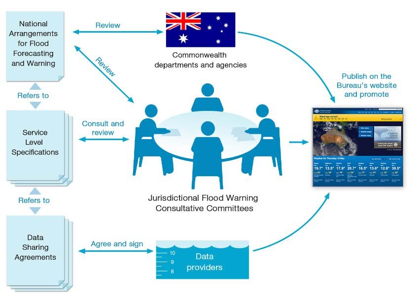
especially to assist the Bureau in its role in flood prediction. Figure 2 shows the spatial coverage and
ownership of rainfall and river level gauges across Australia.
The Intergovernmental Agreement includes agreement that the States and Territories will provide the
Bureau with relevant flood information that is in their possession or control in order to discharge its
responsibilities. Strong cooperative relationships have been developed among the agencies concerned
and the Bureau of Meteorology. The detail of these arrangements varies between jurisdictions and is
described in separate Data Sharing Agreements established for each jurisdiction between the Bureau
and agencies providing data.
7National Arrangements for Flood Forecasting and Warning
Figure 2: Rainfall and River stations available to the Bureau for flood warning services
showing ownership (as at January 2017)
8National Arrangements for Flood Forecasting and Warning
3. Flood Warning System Design
The goal of flood warning is to help flood management agencies and the members of flood prone
communities to understand the nature of developing floods so that they can take action to mitigate their
effects. The purpose of a flood warning is to provide advice on impending flooding, so people can take
action to minimise its negative impacts. This will involve some people taking action on their own behalf
and others doing so as part of agency responsibilities. A flood warning system is a set of connected
activities (or elements) designed to operate together to achieve this purpose. Flood warning systems in
Australia are designed using the concept of the Total Flood Warning System (TFWS).
3.1 Total Flood Warning System
This concept (illustrated in Figure 3) has been developed to describe the full range of elements that must
be developed if flood warning services are to be applied effectively.
.
Figure 3: The components of the Total Flood Warning System (Australian Emergency
Manual Series, Manual 21 Flood Warning, AIDR, 2009)
At its simplest, an effective flood warning service can be defined as having six components (AIDR,
2009):
Monitoring and Prediction: Detecting environmental conditions that lead to flooding, and predicting
river levels during the flood;
9National Arrangements for Flood Forecasting and Warning
Interpretation: Identifying in advance the impacts of the predicted flood levels on communities at risk;
Message Construction: Devising the content of the message which will warn people of impending
flooding;
Communication: Disseminating warning information in a timely fashion to people and organisations
likely to be affected by the flood;
Protective Behaviour: Generating appropriate and timely actions and behaviours from the agencies
involved and from the threatened community; and
Review: Examining the various aspects of the system with a view to improving its performance.
For a flood warning system to work effectively, these components must all be present, and they must be
integrated rather than operating in isolation from each other.
The activities involved within each of these elements are shared among agencies at all levels of
government. The integration of the activities such that the total system operates effectively and efficiently
can present significant coordination issues. A more detailed coverage of the design of the TFWS is found
in Manual 21 Flood Warning 11 (AIDR, 2009).
3.2 Flood Preparedness and Planning
Flood warning systems are designed to operate for the period immediately before and during flood
events. To be fully effective in their operation, it is important that the target community is prepared to
receive and act on the warnings provided. This requires that they be made aware of their own risk, how
the warning system has been designed to provide the opportunity to mitigate the risk they face from the
flood, and what to do when they learn of the imminent threat of flooding through a flood warning.
In addition to understanding arrangements for the establishment and operation of the Total Flood
Warning System, an important part of the picture regarding flood warning arrangements is to ensure
the community is aware of:
• Whether or not they are at risk from flooding.
• If there is a flood warning system covering the area where they live and work or may be travelling.
• What they need to do to be prepared.
• How the flood warning system is maintained and kept in a state of readiness.
• How they will be alerted.
• What they should do when they learn of an imminent threat from flooding.
11
Manual 21 Flood Warning (AIDR, 2009) https://knowledge.aidr.org.au/media/1964/manual-21-flood-warning.pdf
10National Arrangements for Flood Forecasting and Warning
Putting the necessary arrangements in place for ensuring this understanding is also a shared
responsibility for the community and relevant government agencies and is part of what is normally
referred to as flood preparedness. While it is not intended to cover this activity in detail in this document,
it is important that the arrangements for the above elements of flood preparedness are kept in view as
part of any comprehensive picture of flood warning arrangements. The reader is referred to Manual 20
Flood Preparedness 12 (AIDR, 2009) for a more comprehensive coverage.
It is also important that flood warning systems be kept in a state of readiness so that they operate
effectively with the little advance notice that is normally available, and that investments made in
improving the existing system or implementing new systems between floods is planned effectively.
System review and planning new investments in flood warning systems will be covered in later sections.
12
Manual 20 Flood Preparedness (AIDR, 2009) https://knowledge.aidr.org.au/media/1963/manual-20-flood-preparedness.pdf
11National Arrangements for Flood Forecasting and Warning
4. Flood Warning Arrangements – National
Summary
This section first lists the principles that have guided the establishment of current national arrangements,
which have evolved from earlier Commonwealth Government decisions and subsequent consultation
processes and more recently from the Intergovernmental Agreement. The arrangements focus mainly
on roles and responsibilities for both the operational component as well as the strategic planning and
development of the service. Linkages with flood preparedness and planning activities are made but the
specific roles and responsibilities for these activities are not included. A broad overview of the role of
each level of government and the community will be presented, followed by a more detailed description
of the various roles in the operation of the TFWS during flood episodes. Typical activities of each level
of government in both TFWS operations and during the periods leading up to and following flooding
have been included as separate appendices.
4.1 National Arrangements - Principles
The principles behind the current arrangements are that:
• Flood warning in Australia involves agencies from Commonwealth, State/Territory and Local
Government, regional authorities, and organisations that contribute to the data observing network.
• Flood warning services are best provided through a cooperative approach involving all these
parties. It must also be recognised that all these parties make up the flood warning service
whether they be an agency, private entity or individual and they all have some degree of service
ownership.
• Flood warning arrangements need to recognise the whole-of-nation resilience based approach to
disaster management adopted in the National Strategy for Disaster Resilience 13 as a shared
responsibility between governments, communities, businesses and individuals.
• Effective flood warning services are provided where beneficiaries have a direct involvement in the
provision of the service and contribute to its cost.
• Effective flood warning services rely on utilising the existing strengths of partner agencies, private
entities and communities.
• Free near real-time access to rainfall, stream level and stream flow observations are to be
provided to the Australian community.
• National arrangements should be designed so as to move the current arrangements and practices
13
To view the National Strategy for Disaster Resilience:
https://www.ag.gov.au/EmergencyManagement/Documents/NationalStrategyforDisasterResilience.PDF
12National Arrangements for Flood Forecasting and Warning
that apply in each jurisdiction toward national best practice 14.
• National arrangements should recognise that flood preparedness activities (outside flood
episodes) designed to ensure the target community is fully ready and able to respond are a crucial
part of the overall set of arrangements.
• Because of the very localised nature of flash flooding, the prime responsibility for flash flood
warning lies with States and Territories working in partnership with local government (where
appropriate) within their jurisdictions.
4.2 Roles of Government and Community
The role played by each level of government in flood forecasting and warning is generally consistent
within each jurisdiction and is described in the following. A more detailed breakdown of how each level
of government and the community contributes to the different elements of the TFWS is given in Appendix
1.
Commonwealth Government Role:
• The Bureau delivers flood forecasting services through a National Operations Centre in
Melbourne and forecasting centres in each State and Territory (except the Australian Capital
Territory). These activities utilise data networks supplied under cooperative arrangements with
State, Territory and Local Government agencies. The Bureau disseminates flood warnings to
other agencies and the community through the media as well as its website, which also displays
all data collected and used for flood forecasting and warning.
• Emergency Management Australia (Department of Home Affairs) is home to the Australian
Government Crisis Coordination Centre (AGCCC)
− To connect relevant Australian Government, State and Territory agencies and consolidate
Australian Government actions during complex national crises, and
− To develop a single, timely and consistent picture or understanding of a crisis, its implications
and the national capacity to respond.
• The Bureau provides a component of the real-time data collection network used for flood
prediction.
• The Bureau provides a range of supplementary services to support State, Territory and Local
Government agencies in the planning, establishment and operation of riverine flood warning
14
For a guide on best practice refer to Manual 21 Flood Warning (AIDR, 2009):
https://knowledge.aidr.org.au/media/1964/manual-21-flood-warning.pdf and Handbook 7 (AIDR 2017) Managing the
Floodplain: A Guide to Best Practice in Flood Risk Management in Australia.
https://knowledge.aidr.org.au/resources/handbook-7-managing-the-floodplain/
13National Arrangements for Flood Forecasting and Warning
systems.
• The Bureau supports State, Territory and Local Government activities in flash flood warning by:
− Continuing to work actively with local governments to support the development of such
systems and procedures, in particular through the provision of advice on the design,
implementation and management of flash flood systems through the Flash Flood Advisory
Resource (FLARE);
− Communicating supplementary information (to its standard warning products), such as radar
and rainfall forecasts, directly through the emergency services mechanism established in each
State and Territory;
− Republishing any State, Territory or local government generated flash flooding information on
its website if a mechanism for doing so is agreed and arranged prior to the operational event;
and
− Provision of forecasts and warnings for severe weather conditions and potential heavy rainfall
conducive to flash flooding and to carry out applied research and development to improve the
provision of severe weather information.
State/Territory Government Role:
• Provide a component of the real-time data collection network used for flood prediction and
information.
• Interpret Bureau flood predictions into more localised impacts and prepare and disseminate locally
tailored information based on these predictions to the community at risk.
• Lead responsibility for emergency management and response activities. This includes flood
preparedness and the preparation and operation of flood response plans (including evacuation)
in association with Regional and Local Government groups in accordance with jurisdictional
emergency management and flood risk management arrangements.
• Development of Flood Classification Levels (see later) in conjunction with local government and
the Bureau.
• Support the planning, implementation and operation of flood warning systems as part of
jurisdictional flood risk management plans and strategies.
• Develop and implement community and industry flood awareness programs down to the local
level.
• Share the responsibility for Flash Flood warnings and systems with Local Government.
14National Arrangements for Flood Forecasting and Warning
Regional Agency 15 Level Role:
• Provide a component of the real-time data collection network used for flood prediction and
information.
• Contribute expertise to assist with the interpretation of Bureau flood predictions into local impacts
and with the preparation and dissemination of local warning information.
• Support the planning, implementation and operation of flood warning systems as part of
jurisdictional flood risk management plans and strategies.
Local Government Role:
• Contribute to the real-time flood warning data network either directly or through local cooperative
programs with other agencies.
• Key role in emergency management and response, including flood preparedness activities and
response planning.
• Lead and manage the preparation of flood studies and communicate their outcomes to at-risk
communities and businesses.
• Assist with the interpretation of flood predictions into local impacts and with local warning
dissemination in accordance with jurisdictional emergency management arrangements.
• Promote local flood awareness through locally developed programs and in coordination with
programs of other levels of government.
• Implement and operate flash flood warning systems in collaboration with State and Territory
agencies and with the support of the Bureau through severe weather services and research.
Community Role
• Individuals and business carry a share of the responsibility for building a disaster resilient
community.
• Community members need to be aware of their particular flood risk and be prepared and accept
guidance by relevant authorities in responding effectively to the flood warning information.
• The community has a role to inform itself and contribute to the planning and implementation of
flood response measures.
15 This includes agencies with a jurisdiction extending across part of a State such as Catchment Management Authorities.
15National Arrangements for Flood Forecasting and Warning
4.3 National Arrangements – Total Flood Warning System Operations
4.3.1 Monitoring and Prediction
This role is performed nationally by the Bureau of Meteorology operating through its National
Operations Centre in Melbourne and operational forecasting centres in each capital city (except
Canberra) 16. These centres operate when required on a 24/7 basis and are staffed with specialist
hydrologists and meteorologists involved in monitoring the state of rivers and their catchments and
assessing the likely impact of any forecast rainfall in terms of whether or not flooding is likely in any
particular part of the country. On the basis of this assessment, a Flood Watch can be issued for any
catchment with a potential for future flooding where the issuing criteria have been agreed with
emergency management agencies. These agencies may also be provided with a range of likely flood
scenarios based on likely future rainfalls to assist in their planning. In some jurisdictions, River Alerts
are generated automatically when river levels exceed pre-determined thresholds as an additional
alerting mechanism. When flooding either becomes more certain or commences, specific predictions
of future river levels at pre-determined forecast locations are made. These predictions are made in
accordance with previously specified requirements including critical threshold levels, forecast
accuracy and lead time, and continue for the duration of the flooding.
The Bureau prediction at a forecast location can be expressed in different ways dependent on the
defined service level and the quality (accuracy) of the hydrologic forecasting tool. Normally it is
expressed either as:
• A river level value – e.g. 7.5m
• A river level range – e.g. between 7.5 and 7.8m
• Being above a particular river level value – e.g. greater than 7.5m, or
• A classification (or class) of flooding (based on pre-defined river level thresholds) – e.g. minor,
moderate or major.
Forecast locations and service level requirements are specified in detailed schedules contained in
Service Level Specifications (SLS) for each State and the Northern Territory. The relative timing of
the different flood warning service products is depicted in Figure 4.
16
There are two exceptions; Melbourne Water provides flood forecasting services for Port Philip and Westernport catchments
and the South Australian Department of Environment, Water and Natural Resources provides forecasts for the Lower Murray
River however the status of these forecasting services is currently under review.
16National Arrangements for Flood Forecasting and Warning
Figure 4: Relative timing of flood warning products
Predictions of future river levels are prepared using hydrological forecasting models and other tools.
Model inputs include real-time rainfall and river level data from an extensive network of observing
sites, weather forecast information and data from the national radar network. The Bureau maintains
a sophisticated communications and computing infrastructure with a capability of 24/7 operations.
The Bureau continually improves its capability with the development and implementation of new and
improved hydrological forecasting models, and on-line operational computing and communications
systems.
The rainfall and river level data comes from a network of stations owned and operated by the Bureau
and by State, Territory and other local and regional agencies. The Bureau is responsible for the
standard of data from its own observing sites and this responsibility includes meeting replacement,
maintenance and operating costs. The Bureau owns and operates a portion of the river level network
used for flood warning. However, the majority of the river level data (incl. water levels in dams) is
provided from observing sites owned and operated by other agencies. These partner agencies also
provide a significant portion of the rainfall data. Not all of the data collected by these partner agencies
is for the primary purpose of flood warning. The arrangements whereby data from other agency sites
is provided to the Bureau varies around the country and follow protocols established for each
jurisdiction as described in Data Sharing Agreements and in the Regulations associated with the
17National Arrangements for Flood Forecasting and Warning
Water Act (2007). National standards and a risk-based strategic plan for the further enhancement of
this flood warning infrastructure is currently under development (refer Section 6.3).
Typical activities for each level of government for flood monitoring and prediction are listed in
Appendix 1.
4.3.2 Interpretation of Flood Predictions
A flood prediction is of little value unless people at risk are able to assess what it means in terms of
the risk it presents to them in their individual situation. This requires that the prediction as prepared
by the Bureau be given meaning. The interpretation of flood predictions is done at a number of
different levels and depends on how the prediction is expressed.
Flood Classification Levels
For all forecast and information locations, standardised flood impacts (or flood classifications) have
been determined. These flood classifications describe in general terms the degree and nature of flood
impact at and around the forecast location and relate river levels to expected impacts. The
classifications currently in use are:
Minor - Causes inconvenience. Low-lying areas next to watercourses are inundated. Minor roads
may be closed, and low-level bridges submerged. In urban areas inundation may affect some
backyards and buildings below the floor level as well as bicycle and pedestrian paths. In rural areas
removal of stock and equipment may be required.
Moderate - In addition to the above, the area of inundation is more substantial. Main traffic routes
may be affected. Some buildings may be affected above the floor level. Evacuation of flood affected
areas may be required. In rural areas removal of stock is required.
Major - In addition to the above, extensive rural areas and/or urban areas are inundated. Many
buildings may be affected above the floor level. Properties and towns are likely to be isolated and
major rail and traffic routes closed. Evacuation of flood affected areas may be required. Utility
services may be impacted.
Flood classification levels are determined for each forecast and information location corresponding
to the river level (gauge reading) at which the particular impacts as described above commence. The
Bureau uses these levels to qualify/categorise the flood prediction by the particular classification so
that the expected general impact of the flooding can be communicated with the prediction. Through
this use of standard terms describing flood impacts, the Bureau prediction is given some meaning.
For this to be effective however, it requires that those hearing/receiving the warning understand what
the classification level means to them.
It is important that flood classification levels accurately reflect the impacts at the key river height
stations and State/Territory Emergency Service organisations lead the determination, review and
update of flood classifications in consultation with the Bureau and relevant State and local agencies.
18National Arrangements for Flood Forecasting and Warning
Nationally consistent guidelines have been developed for the establishment and regular review of
the flood classifications, which includes consideration of historic water levels and documented flood
impacts, outputs from flood studies, survey information and local knowledge. Flood Warning
Consultative Committees (see Section 5.4) play a key role in the endorsement of flood classification
levels before being formally adopted.
More Specific Interpretation
When the flood prediction is expressed more precisely, either as a single value or a narrower range
of values, more detailed interpretation is possible. This is normally undertaken either by the
emergency management agency or local government, dependent on the availability of local flood
intelligence. Such flood intelligence allows those agencies to interpret Bureau flood predictions into
more detailed impacts on infrastructure (roads, critical life lines etc.) and communities allowing them
to better target local warning communications on particular areas at risk at the predicted level.
Individuals (households, business owners, etc.) with appropriate detailed knowledge, understanding
and/or experience of the relationship between level at the nearest forecast location and impact at
their location are able to use the Bureau prediction to plan their response.
Flood intelligence can be developed through the gradual collection and systematic recording of
information gathered relating flood impacts to levels on the gauge at the forecast location during
flood episodes as well as through flood studies, especially where these include flood inundation
modelling and mapping exercises.
Typical activities for each level of government involved in interpretation are listed in Appendix 1.
4.3.3 Warning Message Construction and Dissemination
The warning message is the critical link between flood prediction and interpretation on the one hand
and taking appropriate protective action on the other. Current arrangements for providing that link
can be multi-layered and include flood warning messages disseminated by the Bureau but can also
include more localised and targeted communications from emergency management agencies and
local government. Guidance on message construction and composition is provided in the Australian
Government publication
“Choosing your Words” (Attorney-General’s Department, 2008) 17 , and Manual 21 Flood Warning
(AIDR, 2009) 18
The Bureau Flood Watch and Flood Warning messages are disseminated primarily through the web
and the media and are sent directly to emergency management agencies. Emergency management
operations centres are often telephoned on issue of a new or updated warning. The locations for
17
“Choosing your Words” (Attorney-Generals Department, 2008) https://www.ag.gov.au/Publications/Pages/Emergency-
warnings-choosing-your-words.aspx
18
Manual 21 Flood Warning (AIDR, 2009 https://knowledge.aidr.org.au/media/1964/manual-21-flood-warning.pdf
19National Arrangements for Flood Forecasting and Warning
which they are issued are included in the Service Level Specifications for each jurisdiction (see later
appendices). The Bureau has a Memorandum of Understanding with the ABC to ensure priority is
given to the dissemination of warnings.
In some areas the Bureau message as received by the emergency management agency is further
disseminated to local response groups and the community. This may be without any change or may
include some local interpretation and tailored action statements. In other cases, the agency may
separately generate and communicate more localised messages based on the Bureau predictions,
but enhanced with more detailed local knowledge and interpretative information where available.
Typical activities for each level of government involved in warning message construction and
dissemination are listed in Appendix 1.
4.3.4 Communication with Individuals on their Specific Flood Risk
It is important to advise and educate people outside of flood time about their individual flood risk, and
where this is done the warnings disseminated as floods are approaching will generally be better
understood. In many circumstances, people can be provided with the actual gauge height at which
their properties will experience over-ground or over-floor inundation or at which their evacuation route
will be cut.
Arrangements for providing this sort of advice are generally established at the local level, either
through Local Government or State/Territory emergency management agencies.
4.3.5 Generating Flood Response Behaviour – Community Alerting and Local Action
A critical part of any flood warning system is the prompt alerting of the community that flooding will
occur. This alerting must be able to operate at any time and is usually through a variety of means.
The arrangements for alerting communities when they are at risk from natural disasters are
incorporated within the emergency management arrangements for each jurisdiction and normally
rests with Local Government, the State emergency management agency and Police.
To assist in this alerting of local communities a decision may be taken within the agreed protocols to
issue a flood warning with the Standard Emergency Warning Signal (SEWS). The SEWS is used to
communicate emerging situations of extreme danger or when there is a need to warn the public that
they need to take some urgent and immediate action to reduce the potential for loss of life or property.
This short signal should alert the community to take appropriate actions to protect life and property
or to seek guidance from local authorities.
Another means of warning communities is through the use of Emergency Alert (see:
www.emergencyalert.gov.au), the national telephone warning system that may be used by police,
fire and emergency services to warn a community of a likely or actual emergency. Its use will depend
on the circumstances and the system sends a voice message to landline telephones and text
20You can also read