Strategic airports and aviation facilities - State Planning Policy - state interest guidance material - July 2017
←
→
Page content transcription
If your browser does not render page correctly, please read the page content below

State Planning Policy – state interest guidance material

Strategic airports
and aviation
facilities

                                                 July 2017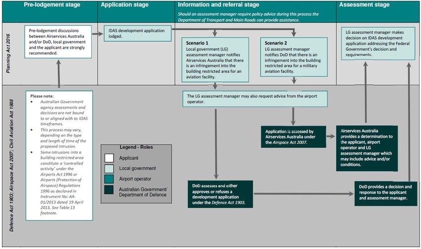
The State of Queensland, July 2017. First published by the Department of Infrastructure, Local Government
and Planning, 1 William Street, Brisbane Qld 4000, Australia.

                    Licence: This work is licensed under the Creative Commons CC BY 4.0 Australia licence.
                    To view a copy of the licence, visit http://creativecommons.org/licenses/by/4.0/.
                    Enquiries about this licence or any copyright issues can be directed to the department by
                    email to info@dilgp.qld.gov.au or in writing to PO Box 15009, City East Qld 4002.

Attribution: The State of Queensland, Department of State Development, Manufacturing, Infrastructure and
Planning.

The Queensland Government supports and encourages the dissemination and exchange of information.
However, copyright protects this publication. The State of Queensland has no objection to this material being
reproduced, made available online or electronically but only if it is recognised as the owner of the copyright and
this material remains unaltered.

             The Queensland Government is committed to providing accessible services to Queenslanders of all
             cultural and linguistic backgrounds. If you have difficulty understanding this publication and need a
             translator, please call the Translating and Interpreting Service (TIS National) on 131 450 and ask
             them to telephone the Department of State Development, Manufacturing, Infrastructure and
             Planning on 13 QGOV (13 74 68).

Disclaimer: While every care has been taken in preparing this publication, the State of Queensland accepts no
responsibility for decisions or actions taken as a result of any data, information, statement or advice, expressed
or implied, contained within. To the best of our knowledge, the content was correct at the time of publishing.

Any references to legislation are not an interpretation of the law. They are to be used as a guide only. The
information in this publication is general and does not take into account individual circumstances or situations.
Where appropriate, independent legal advice should be sought.

An electronic copy of this report is available on the Queensland Government’s Planning website at
https://planning.dilgp.qld.gov.au/
Contents
Using the SPP state interest guidance material .................................................................1
Part 1: Understanding the state interest .............................................................................3
Part 2: Integrating the state interest policies ......................................................................8
Part 3: Mapping ...............................................................................................................14
Part 4: Applying assessment benchmarks .......................................................................17
Part 5: Example planning scheme provisions ...................................................................25
Part 6: Supporting information .........................................................................................29
Appendix 1: General location of aviation facilities ............................................................30
Appendix 2: Aviation facilities—location and type ............................................................31
Appendix 3: Indicative location of strategic airports ..........................................................42
Appendix 4: Strategic airport listing criteria and Queensland Government endorsement
processes ........................................................................................................................43
Appendix 5: Operational airspace ....................................................................................45
Appendix 6: Obstacle limitation surface and height restriction zones ...............................46
Appendix 7: Public safety areas (PSAs) ...........................................................................47
Appendix 8: Guidance on agency roles and contact information ......................................48
Appendix 9: Airport SPP IMS mapping layers ..................................................................54
Appendix 10: Land uses with the potential to adversely impact operational airspace and
aircraft safety ...................................................................................................................55
Appendix 11: Land uses associated with increases in wildlife strikes and hazards ..........57
Appendix 12: Guidance on other statutory approvals required .........................................58
Appendix 13: PSA – Generally compatible and incompatible uses (new or changed
development only) ...........................................................................................................66
Appendix 14: Compatible and incompatible land uses within ANEF contours for the
purposes of development assessment .............................................................................67
Appendix 15: Levels of assessment for development within ANEF contours ....................68
Appendix 16: Desirable indoor design sound levels for sensitive land uses .....................69
Appendix 17: Mapping update processes ........................................................................70
Appendix 18: Guidance on the National Airports Safeguarding Framework .....................74
Appendix 19: Matters to consider when designing development in close proximity to
operational airspace ........................................................................................................76
Appendix 20: Aviaiton legislation and regulation ..............................................................77
Appendix 21: SPP Interactive Mapping System (IMS) mapping updates and data
responsibilities .................................................................................................................78

Strategic airports and aviation facilities
Using the SPP state interest guidance material
The Queensland Government established the State Planning Policy (SPP) to define the
matters of state interest in land-use planning and development. State interests in the SPP
consist of a state interest statement, state interest policies and, where applicable,

                                                                                                       Part 1
assessment benchmarks.

This guidance material has been prepared to support the implementation of the SPP and
the interpretation of the Strategic airports and aviation facilities state interest. Although the

                                                                                                    Understanding the state interest
SPP broadly applies to a range of activities undertaken by state and local governments,
the guidance material is particularly focused on assisting local governments when making
or amending a local planning instrument and when applying the assessment benchmarks
(to the extent relevant).

The SPP does not prioritise one state interest over another, providing flexibility for
decision-makers to respond to specific regional and local circumstances. This allows for
the state interests to be considered in their entirety rather than as individual or separate
priorities. State interests are to be considered in the context of the guiding principles in the
SPP which promote an outcome focused, integrated, efficient, positive and accountable
planning system.

The SPP guidance material is intended to be read in conjunction with the SPP and the
relevant state interest. The SPP guidance material is not statutory in its effect and does
not contain any new policy. It is not mandatory for local governments to use the guidance
material but it is provided to assist with the interpretation and application of the state
interest policies and the assessment benchmarks contained in the SPP.

Strategic airports and aviation facilities                                             1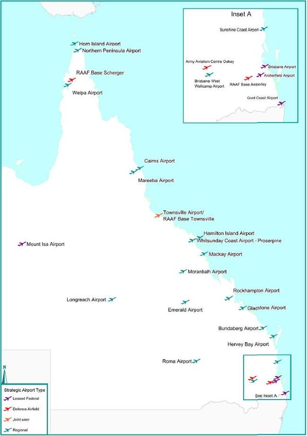
The SPP guidance material is structured as follows:

Part 1: Understanding the state interest – This section briefly explains why a particular
matter is a matter of state interest, describes the purpose of the relevant state interest
statement and defines the core concepts associated with the state interest.

                                                                                                   Part 1
Part 2: Integrating the state interest policies – This section provides background and
further explanation for each of the state interest policies defined in the SPP. It also
provides examples and options regarding how to appropriately integrate each state

                                                                                                Understanding the state interest
interest policy into a local planning instrument.

Part 3: Mapping – This section identifies and explains the mapping layers contained in
the SPP Interactive Mapping System (IMS) relevant to a particular state interest. It also
clarifies how a local government can locally refine state mapping in certain instances and
outlines where online mapping for the state interest can be accessed (if relevant).

Part 4: Applying assessment benchmarks – In accordance with the Planning
Regulation, an assessment manager or referral agency must have regard to the SPP
when assessing a development application. For some state interests, there are also
specific assessment benchmarks that must be used by a local government for
development assessment. This section outlines the development applications to which the
assessment benchmarks apply and how a development application may demonstrate
compliance with these benchmarks, to the extent that these are relevant. The assessment
benchmarks contained in the SPP will apply to assessable development in addition to any
assessment benchmarks contained in a local planning instrument, to the extent of any
inconsistency.

Part 5: Example planning scheme provisions – This section provides example planning
scheme provisions that a local government may choose to adopt, or to adapt, for its local
planning instrument. It is important to note that the example planning scheme provisions
provided may only be in relation to a particular aspect of a state interest, rather than
addressing all of the particular state interest policy requirements.

Part 6: Supporting information – This section provides a list of technical resources that
a local government may wish to consider when preparing for making or amending a
planning scheme. This section also provides a glossary of terms and acronyms used
throughout the SPP guidance material.

Where text in this guidance material is in a coloured text box, it is an excerpt from the SPP
and is either the state interest statement, state interest policy or the assessment
benchmarks applicable to the Strategic airports and aviation facilities state interest.

Any queries related to the SPP guidance material or the SPP should be sent to
SPP@dilgp.qld.gov.au.

Strategic airports and aviation facilities                                         2
Part 1: Understanding the state interest

       State interest statement

                                                                                                   Part 1
       The operation of strategic airports and aviation facilities is
       protected, and the growth and development of Queensland’s
       aviation industry is supported.

                                                                                                Understanding the state interest
Strategic airports and aviation facilities play a key role in facilitating economic growth in
Queensland. All sectors of the Queensland economy, including tourism, trade, logistics,
and business rely on the efficient movement of people and freight through strategic
airports. The continued growth and development of Queensland’s aviation industry
depends on access to strategic airports. Strategic airports are also a vital part of
Queensland’s passenger transport infrastructure network, ensuring communities can
access employment and recreation opportunities, and vital services such as health and
welfare.

Military airfields are integral to the national defence system and support emergency
service activities and make significant contributions to surrounding regional economies.

The Australian and Queensland governments have a direct role in protecting the safety
and efficiency of existing and future aircraft operations at strategic airports and aviation
facilities, to sustain economic growth in Queensland.

Core concepts
Aviation facilities
Aviation facilities are those shown in Appendix 1 and listed at Appendix 2.

Strategic airports
Strategic airports are those shown at Appendix 3 and identified in the SPP, Table 2:
Strategic airports. Appendix 4 lists the criteria which airports must meet to be considered
a ‘strategic airport’.

Appendix 1 of this guidance material shows the general location of aviation facilities, while
Appendix 2 states the specific locations and types of these facilities. Appendix 3 shows
the indicative location of strategic airports.

There are four categories of strategic airports:
1. leased federal
2. defence airfields
3. joint-user
4. regional (either owned by a local authority or private entity or leased from the state).

The process for an airport being listed as a strategic airport under the SPP is outlined in
Appendix 4.

Operational airspace
Operational airspace is a volume of airspace that must be kept clear of obstructions to
enable safe and efficient take-off, landing and maneuvering of aircraft (see Figure 1 and
Figure 2). For more information on operational airspace, refer to Appendix 5.

Strategic airports and aviation facilities                                            3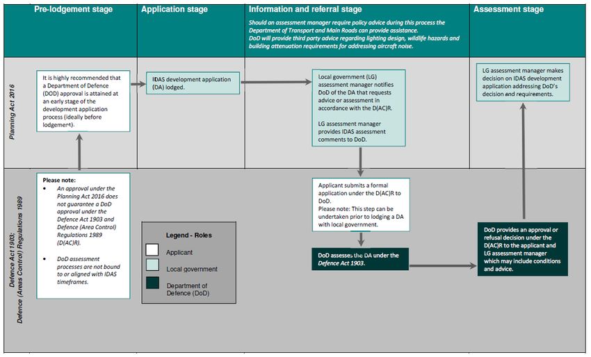
The SPP Integrated Mapping System (IMS) uses the following mapping layers to define
operational airspace and ensure it is protected:

Obstacle limitation surface (OLS) – defines the lowest extent of operational airspace for
leased federal and regional airports (see Figure 1).

                                                                                                Part 1
Height restriction zones – are applied to defence airfields and joint-user airfields, and
may limit the height of new structures or additions to existing structures (see Figure 2).

                                                                                             Understanding the state interest
Figure 1: Isometric view of operational airspace
(Source: National Airports Safeguarding Framework Guidelines)

Figure 2: Height restriction zones around Townsville Airport / RAAF Base Townsville
(Source: SPP Integrated Mapping System (07/02/2017)

For more information on OLS and Height restriction zones, refer to Appendix 6.

PANS-OPS
The Procedures for Air Navigation Services – Operations (PANS-OPS) is a different
component of operational airspace and is generally located higher than the OLS. The
PANS-OPS is designed to allow take-off, landing and approach procedures based entirely
on navigation using aircraft instruments. The PANS-OPS is not currently displayed in the
SPP IMS due to the complexity and changing nature of the surface. However, a
development proposing to intrude into operational airspace will trigger assessment by an
airport operator and the Australian Government who will consider the impacts on both the
OLS and PANS-OPS.

Strategic airports and aviation facilities                                          4
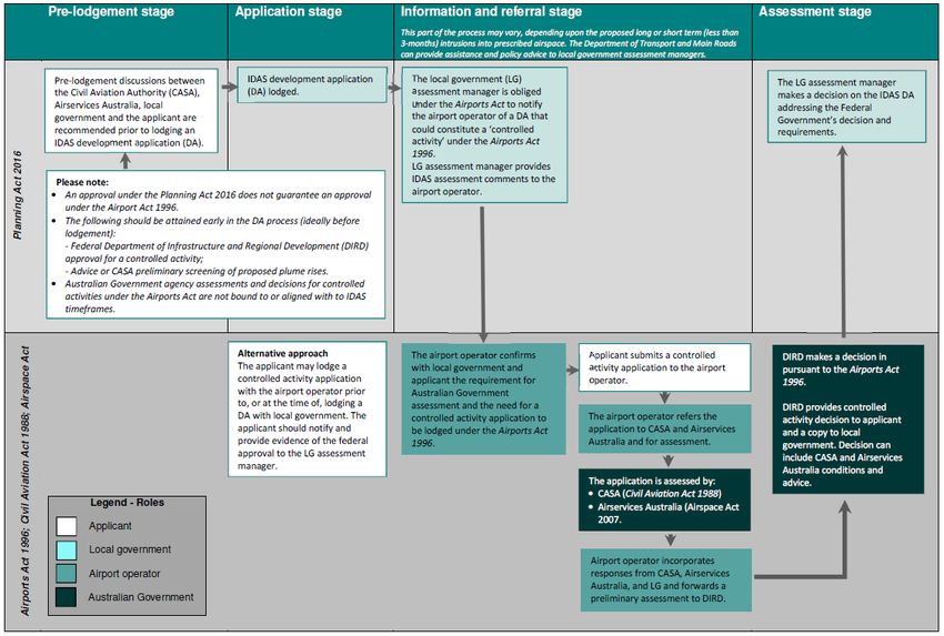
Australian Government role
Part 12 of the Airports Act 1996 and the Airports (Protection of Airspace) Regulations
1996 establishes mechanisms for the declaration of ‘prescribed airspace’ at and around
leased federal airports.

                                                                                                   Part 1
The Civil Aviation Safety Authority (CASA) sets the standards which determine the OLS
and PANS-OPS surface for strategic airports. An airport operator is responsible for
determining the OLS and PANS-OPS surface applicable to the airport. Height Restriction
Zones for Queensland’s defence airfields are depicted by maps in the schedules of the

                                                                                                Understanding the state interest
Defence (Areas Control) Regulations. Under Part 139 of the Civil Aviation Safety
Regulations, CASA must be notified of any object extending to a height of 110 metres or
more above ground level (even if the obstacle to located outside of OLS airspace). Any
object extending to a height of 150 metres or more above ground level is considered to be
an obstacle unless assessed by CASA to be otherwise.

Public safety areas
A public safety area (PSA) is a defined area at the end of a strategic airport’s runway
where there is potentially an increased risk of an aircraft incident occurring. A PSA is 1000
metres long, 350 metres wide closest to the runway end, tapering to a width of 250 metres
furthest from the runway (see Figure 3).

Circumstances in which a PSA would be required for a strategic airport are set out in
Appendix 7.

Figure 3: Dimensions and application of a PSA

The Australian Noise Exposure Forecast (ANEF) system
The ANEF system uses contours to show the amount of total noise energy received by
locations on the ground near an airport on an annual average day. ANEF contours are
based on average daily sound pressure levels which are measured in decibels (dB). The
ANEF charts displayed on the SPP IMS show noise exposure contours for 20, 25, 30, 35
and 40 or greater ANEF.

Aviation facilities
An aviation facility is a communication, navigation or surveillance facility that allows:
• pilots to navigate while en-route between airports

Strategic airports and aviation facilities                                            5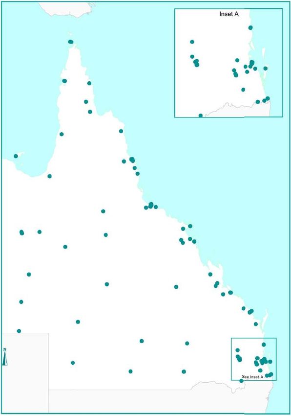
•    pilots to utilise navigation aids to conduct instrument approach procedures
•    dialogue between pilots and air traffic control
•    air traffic control to monitor and confirm an aircraft location.

The SPP supports the protection of aviation facilities and their associated systems and

                                                                                                     Part 1
processes that safely manage the flow of aircraft into, out of and across Australian unified
airspace. Aviation facilities are crucial to the safety and operations of aircraft across
Australia. Airservices Australia and Department of Defence (DoD) rely on them to ensure
the safety of civilian and military aircraft operations, thereby maximising aircraft flying

                                                                                                  Understanding the state interest
safely in our skies.

The general location of aviation facilities is shown at Appendix 1. Appendix 2 provides
specific locational information, and lists the types of aviation facilities protected under the
SPP. Radio links and radar monitors sites are not protected under the SPP.

The aviation facilities listed in Appendix 2 are:
• directly associated with the operations of a strategic airport listed in SPP Table A and
    operated by the airport owner; or
• a system-wide (or en-route) aviation facility operated by Airservices Australia, DoD or
    another agency under contract with the Australian Government.

What is a building restricted area (BRA) of an aviation facility?
A BRA is the airspace surrounding an aviation facility that needs to be clear from physical
intrusions including plume rises, competing radio transmissions and significant
electrical/electromagnetic emissions (for example, arc welding) and reflective surfaces
that could interfere with transmissions needed for the airport to function effectively. The
purpose of a building restricted area is to trigger the assessment of potential impacts on
aviation facilities from proposed development and its associated activities.

The extent of the BRA depends on the type of aviation facility, but it can extend to 15
kilometres. A BRA is divided into different zones within which different types of
development and activities are considered compatible. BRAs, constraints and referrals
required for each type of aviation facility are described in detail in the National Airports
Safeguarding Framework Principles and Guidelines – Guideline G, Attachment 3
https://infrastructure.gov.au/aviation/environmental/airport_safeguarding/nasf/nasf_principl
es_guidelines.aspx.

The roles and relationships between airport operators and different levels of government
are explained at Appendix 9, and summarised by Figure 4.

Strategic airports and aviation facilities                                             6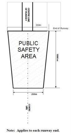
Part 1
 Federal Government
   •     Implements international standards and recommendations.
   •     Responsible for civil and defence aviation legislation, regulation, policy and standards
         associated with aviation surveillance and security and air safety investigation.

                                                                                                        Understanding the state interest
   •     Regulates Australian-administered airspace.
   •     Provides, operates and maintains Australia’s network of aviation facilities.
   •     Endorses ANEF contours for airports.
   •     Issues approvals for intrusions into operational airspace around leased federal airports and
  Figure 4: Airport
       military                – overview of key agency relationships and roles
                     planningairfields.
                and joint-user
   •     Provides advice to local governments regarding development impacts on operational
         airspace.
   •     Assesses referred development applications.
   •     Provides pre-lodgement advice to development proponents.
   •     Provides DoD mapping to state government.

 State government
   •     Develops planning policy to be integrated in local planning instruments.
   •     Coordinates SPP IMS mapping to be integrated in local planning instruments.
   •     Reviews new and amended local planning instruments from local governments.
   •     Assesses potential strategic airports.
   •     Establishes and maintains deeds of agreement with airport operators for data supply and use
         to support SPP implementation.
   •     Reviews and provides feedback on leased federal airport master plans.

 Local government
   •     Prepares local planning instruments, in accordance with SPP.
   •     Assesses development applications, incorporating advice from airport operators and the
         federal government.
   •     Notifies airport operators and DoD of relevant development proposals.

 Airport operator
   •     Publishes five-yearly master plans (leased federal only).
   •     Preliminary assessment of development applications.
   •     Refers development applications to federal government as necessary.
   •     Provides advice to local government.
   •     Prepares and provides ANEF charts to federal government.
   •     Provides operational airspace and ANEF mapping to state government.

Figure 4: Airport planning – overview of key agency relationships and roles

  Strategic airports and aviation facilities                                                        7
Part 2: Integrating the state interest policies
When making or amending a local planning instrument, each local government is required
to consider all state interests in the SPP and appropriately integrate those state interests
applicable to their local area.
Part 2
Appropriately integrating a state interest requires all state interest policies to be
considered by a local government, but it does not necessarily mean a local government
must address each and every state interest policy when making or amending a local
planning instrument. For example, if a local government needs to balance competing state
Integrating the state interest policies
interests in a local planning instrument, it may mean not be possible to address all
policies.
This balancing of state interests may mean that the planning scheme preferences one
state interest policy over another. This outcome will be considered as part of the state
interest review. Ministerial approval means the approach taken by the local government in
balancing the state interest polices is endorsed by the state.
This section provides examples for how to appropriately integrate each state interest
policy for the Strategic airports and aviation facilities state interest.
State interest policy (1)
Strategic airports and aviation facilities are identified, including the associated
Australian Noise Exposure Forecast (ANEF) contours, obstacle limitation
surfaces or height restriction zones, public safety areas, lighting area buffers,
light restriction zones, wildlife hazard buffer zones, and building restricted areas.
Local planning schemes should ensure that the locations of strategic airports and aviation
facilities are appropriately identified in the planning scheme. The SPP IMS includes
mapping layers depicting constraints associated with strategic airports and aviation
facilities.
Local governments should avoid using Australian Noise Exposure Concept (ANEC)
contour and alternative aircraft noise metrics (such as N70s) to assess aircraft noise
impacts on development applications.
How to appropriately integrate the policy
1.1 Include the following overlays to protect strategic airports and aviation facilities:
• operational airspace
o OLS and OLS contour (for leased federal and regional strategic airports); or
o height restriction zones (for defence airfields and joint-user airfields)
• light restriction zone (lighting intensity zones A–D)
• lighting area buffer (6km)
• wildlife hazard buffer zone (3, 8 and 13km)
• airport public safety areas
• ANEF contours (20-25, 25-30, 30-35, 35-40, 40 or greater)
• building restricted areas (BRAs) for aviation facilities (except glide path and localiser
facilities – see 1.2 below).
Available information will vary depending on the airport or aviation facility. For information
on the mapping layers applicable to each strategic airport refer to Appendix 9.
Strategic airports and aviation facilities 81.2 Source mapping data directly from the Department of Transport and Main Roads
(DTMR). See Appendix 8.
Part 2
State interest policy (2)
The safety, efficiency and operational integrity of strategic airports are protected.
Development and associated activities:
Integrating the state interest policies
(a) do not create incompatible intrusions, or compromise aircraft safety, in
operational airspace
What constitutes an intrusion into operational airspace?
Intrusions into operational airspace may create a safety hazard for aircraft and can limit
aviation operations into and out of an airport. A single intrusion, or the cumulative impact
of multiple intrusions, may seriously affect efficient runway utilisation, cause airspace
congestion and reduce the effective handling capacity of an airport.
The safety and efficiency of operational airspace can be compromised not only by
buildings and structures, but also by ‘outputs’ (such as smoke, plumes and lighting) and
congregations of wildlife, particularly birds or bats (refer Appendix 10).
Intrusions by physical or transient obstructions
Potential physical or transient intrusions into operational airspace include:
• buildings and structures
• landscaping that at maturity will intrude into operational airspace
• works and advertising devices (where operational airspace is in proximity to ground
level).
Intrusions by activities associated with development
Activities which may be associated with development that have the potential to intrude into
operational airspace include:
• the operation of cranes, concrete pumpers or other equipment used during
construction
• transient activities, such as parachuting, hot air ballooning, hang-gliding, operation of
remotely piloted aircraft (RPA) (for example, drones) and shooting on firearm ranges
(for example, shooting bullets, ordnance or lasers).
The operation of RPA in operational airspace can adversely impact on the safety and
efficiency of aircraft operations. CASA regulates the operation of RPAs under the Civil
Aviation Safety Regulations available.
Intrusions by external lighting and reflections
Pilots often rely on runway lights and approach lights to safely approach and land aircraft.
Lighting and reflective surfaces associated with, and emanating from, development within
a light restriction zone or lighting area buffer can have adverse effects on aircraft if it is
configured in such a way as to:
• confuse pilots because of similarities with approach or runway lighting
• distract or interfere with a pilot’s vision, e.g. because of brightness or glare.
Strategic airports and aviation facilities 9Intrusions by wildlife
All wildlife within the wildlife hazard zone should be regarded as a potential hazard to
aircraft safety.
Part 2
Most wildlife strikes occur on and in the vicinity of airports, where aircraft fly at lower
elevations. The risk of a wildlife strike by an aircraft is relative to the level and form of
wildlife activity within the airport’s boundary and surrounds. Certain land uses can attract
wildlife which then migrates onto an airport or across flight paths within operational
Integrating the state interest policies
airspace, increasing the risk of strikes.
Intrusions by emissions and particulates
Gaseous plumes
Development incorporating stacks or vents that can emit high velocity gaseous plumes
exceeding 4.3m per second have the potential to adversely impact aircraft operations.
Exhaust plumes can originate from several sources including:
• stacks or vents from industrial facilities
• industrial flares creating an instantaneous release of hot gases
• cooling towers producing large volumes of buoyant gases
• exhaust gases from power generation facilities.
Airborne particulates
Development or associated activities (such as extractive industries) with the potential to
emit steam, dust, smoke, ash and other airborne particles or pollutants into operational
airspace may affect aircraft safety by reducing pilot or air traffic control visibility, or
impacting engine operation.
How to appropriately integrate the policy
2(a)1 When allocating land uses in areas where development has the potential to impact
on operational airspace, consider giving preference to uses that are unlikely to
adversely affect operational airspace and aircraft safety. Adverse impacts on
operational airspace can arise from land uses, development and associated
activities listed in Appendix 10 and Appendix 11.
Land in the vicinity (indicated by OLS and wildlife hazard buffer zone mapping) of a
strategic airport should only be allocated for a use listed in these tables where the
local government can demonstrate that the use is, or could be, compatible and will
not result in adverse impacts on operational airspace or aircraft safety.
2(a)2 Seek advice from airport operators when undertaking land use planning in the
vicinity of a strategic airport.
2(a)3 Consider code provisions that do not allow permanent or temporary physical or
transient intrusions into operational airspace, unless approved under relevant
federal legislation. Code provisions should include an editor’s note, or similar,
which references the requirement to refer a development application to the airport
operator or DoD, if it proposes to intrude into the operational airspace of a leased
federal airport, defence airfield or joint-user airfield (Refer to Appendix 12 for
further detail on this requirement and process). The SPP model code provides
editor’s notes to assist proponents with the Australian Government assessment
process.
Strategic airports and aviation facilities 10State interest policy (2)
The safety, efficiency and operational integrity of strategic airports are protected.
Development and associated activities:
Part 2
(b) avoid increasing risk to public safety in a public safety area
Integrating the state interest policies
PSAs define the area in which development should be restricted to protect the safety of
aircraft passengers, property and people on the ground in the event of an aircraft incident
during landing or take-off. As such, planning schemes should avoid increasing risk to
public safety in a PSA.
How to appropriately integrate the policy
2(b)1 Consider planning scheme provides that provide certainty about land uses
permissible in a PSA. This can be achieved by ensuring any zoning is for
compatible land uses and including planning provisions which do not allow, or
intensify, incompatible development and uses in a PSA. Examples of compatible
and incompatible land uses within a PSA are listed in Appendix 13.
State interest policy (2)
The safety, efficiency and operational integrity of strategic airports are protected.
Development and associated activities:
(c) are compatible with forecast levels of aircraft noise within the 20 ANEF
contour or greater [as defined by Australian Standard 2021–2015:
Acoustics—Aircraft noise intrusion—Building siting and construction (AS
2021), adopted 12 February 2015] and mitigate adverse impacts of aircraft
noise.
ANEF contours indicate areas around an airport which are exposed to aircraft noise of
certain levels; the higher the ANEF value, the greater the noise exposure. To mitigate
reverse amenity issues and assist ongoing viability of strategic airports, it is important to
identify areas affected by aircraft noise and prioritise suitable land uses in these locations.
It should be recognised that the effects of aircraft noise are not confined to areas defined
as being within the 20 ANEF contour or greater. A site outside the 20 ANEF contour, may
experience aircraft noise, but noise from sources other than aircraft may generally be
more dominant.
How to appropriately integrate the policy
2(c)1 When allocating land uses in areas affected by significant levels of aircraft noise
within the ANEF 20 or greater contour, consider giving preference to those land
uses that are compatible with forecast levels of aircraft noise. Land should only be
allocated for a use listed in Appendix 14 if it is compatible, or compatible subject to
conditions.
Strategic airports and aviation facilities 112(c)2 Consider using both ANEF contours and alternative noise contours (e.g. N-contour
and Australian Noise Exposure Concept mapping) to inform strategic decisions.
Alternative noise contours generally provide a good indication of the frequency and
loudness of aircraft noise events. They are complementary tools to inform strategic
land use planning. Notwithstanding, these maps should not be used as a
development assessment tool, as they may not have been subject to the same
Part 2
level of scruitiny from relevant authorities as ANEF contours.
For further information refer to the National Airports Safeguarding Framework,
Guideline A: Attachment 1 Alternative Aircraft Noise.
Integrating the state interest policies
2(c)3 Measures for airports without an ANEF:
An ANEF chart may not be available for airports with low frequencies of scheduled
regional passenger transport flights. In such cases, land-use planning and
development assessment for noise-sensitive development should use Appendix E
of Australian Standard AS 2021–2015: Acoustics – Aircraft noise intrusion –
Building siting and construction (AS 2021).For planning purposes, a 5km zone of
influence should be taken into account, depending on the amount of traffic at the
airport for which an ANEF chart is unavailable.
2(c)4 Consider provisions consistent with appendix 14, 15 and 16.
State interest policy (3)
Development complements the role of a strategic airport as an economic, freight
and logistics hub, and enhances the economic opportunities that are available in
proximity to a strategic airport.
Stategic airports play a key role in facilitating economic growth in sectors of the
Queensland economy such as; tourism, trade, logistics and business. Local governments
can capitalise on the economic opportunities provided by strategic airports by ensuring
that complementary land uses are planned surrounding strategic airports.
How to appropriately integrate the policy
3.1 Consider strategic framework and land-use strategies that support development in
proximity to strategic airports that complement the aviation industry.
3.2 Consider (through zoning, for instance) complementary land uses surrounding a
strategic airport such as:
(a) aviation industry activities
(b) compatible development that depends on or gains economic advantage from
being in proximity to a strategic airport. For example, an air charter business,
service station or car parking facility
(c) compatible development that supports the role of the strategic airport as a critical
freight and logistics hub, e.g. an air freight depot, or logistics or distribution
centre.
3.3 Ensure that land surrounding a strategic airport is not allocated for non-
complementary land uses (see appendices 10, 11, 13 and 14).
Strategic airports and aviation facilities 12State interest policy (4)
Aviation facilities are protected by avoiding development and associated
Part 2
activities within building restricted areas that may affect the functioning of the
aviation facilities.
Integrating the state interest policies
The ability for aircraft to operate safely and effectively can be compromised by
development and associated activities that intrude into the BRA of an aviation facility. As
such, planning schemes should integrate measures to avoid these intrusions.
How to appropriately integrate the policy
4.1 Through the strategic framework, land-use strategies, tables of assessment and code
provisions, protect the function of aviation facilities from the adverse impacts of
development and associated activities.
4.2 Consider land-use strategies that ensure potential development and associated
activities will not create an intrusion into a BRA or interfere with the function of an
aviation facility. To function effectively, a BRA needs to be clear of permanent or
temporary:
• physical intrusions into the ‘line of sight’ between transmitting and receiving
devices
• radio frequency interference
• electromagnetic emissions that will interfere with signals transmitted by the
facility (e.g. arc welding)
• reflective surfaces that could deflect or interfere with signals transmitted by the
facility
• plume rises.
4.3 Seek guidance from Airservices Australia and the National Airports Safeguarding
Framework (NASF) Guideline G, Attachment 3, to inform BRA specifications for each
aviation facility. This is particularly important for glide path and localiser facilities
which are not mapped in the SPP IMS.
State interest policy (5)
Key transport corridors (passenger and freight) linking strategic airports to the
broader transport network are identified and protected.
Strategic airports need to be linked to the broader transport network for their operations to
be viable. Without roads and railways the airport would not be able to be supplied with the
passengers, freight, goods and services required to operate.
How to appropriately integrate the policy
5.1 Identify key linkages and consider strategies to protect them (code provisions, for
instance) from development which would compromise the function of the transport
route.
Strategic airports and aviation facilities 13Part 3: Mapping
To support the SPP, wherever possible and to the extent relevant, matters of state interest
are spatially represented as layers included in the SPP IMS. The mapping is necessary to
help local government, the community and industry understand and interpret where and
how state interest policies and assessment benchmarks included in the SPP apply.
Part 3
Several mapping layers contained in the SPP IMS are prepared by entities other than the
Department of Infrastructure, Local Government and Planning and may serve an
additional purpose outside the Queensland planning system. Where relevant, the SPP
Mapping
IMS represents the single point of truth for the spatial representation of the state interests
expressed in the SPP.
Appendix 1 of the SPP identifies three categories of mapping layers provided or referred
to in the SPP IMS that are intended to be used in one of the following ways:
Category 1 – State mapping layers that must be appropriately integrated in a local
planning instrument in a way that achieves the relevant state interest
policy.
Category 2 – State mapping layers that must be appropriately integrated, and can be
locally refined by a local government in a local planning instrument in a
way that achieves the relevant state interest policy.
Category 3 – State mapping layers that are provided for local government information
purposes only.
The SPP IMS is located at: https://planning.dilgp.qld.gov.au/maps. Any queries related to
the SPP mapping should be sent to mappingenquiries@dilgp.qld.gov.au.
This section provides clarity regarding the mapping layers on the SPP IMS relevant to the
Straegic airports and aviation facilities state interest.
Mapping layers
ANEF contour layers
The ANEF system is a measure of the aircraft noise exposure levels
Purpose
around airports.
Mapping category Category 1
Data custodian DTMR
Airports Act 1996 (leased federal and Joint-user only)
Airservices Act 1995
Head of power Transport Planning and Coordination Act 1994
National Airports Safeguarding Framework (refer Appendix 18)
Appendix 17 sets out the mapping layer change process.
Obstacle limitation surface layers
Obstacle limitation surface (OLS) – defines the lowest extent of
operational airspace for leased federal and regional airports that must
Purpose
remain clear of any obstacles, activities or intrusions that could distract or
interfere with the safe operation of an aircraft.
Mapping category Category 1
Data custodian DTMR
Strategic airports and aviation facilities 14Regional airports:
Airspace Act 2007
Airspace Regulations (2007)
Transport Planning and Coordination Act 1994
National Airports Safeguarding Framework
Head of power
Part 3
Leased federal:
Airports Act 1996
Airports (Protection of Airspace) Regulations 1996
Transport Planning and Coordination Act 1994
National Airports Safeguarding Framework (refer Appendix 18)
Mapping
Appendix 17 sets out the mapping layer change process.
Airport public safety area
PSAs define the area in which development should be restricted to protect
Purpose the safety of both aircraft passengers, property and people on the ground
in the event of an aircraft incident during landing or take-off.
Mapping category Category 1
Data custodian DTMR
Applicable strategic airport runways:
Transport Planning and Coordination Act 1994
Head of power
National Airports Safeguarding Framework (refer Appendix 18)
Appendix 17 sets out the mapping layer change process.
Light restriction and buffer layers
The Light restriction zone and Lighting area buffer 6km define the area in
Purpose which lighting and reflective surfaces associated with, and emanating from
development should be limited.
Mapping category Category 1
Data custodian DTMR
All strategic airports:
Civil Aviation Act 1998
Transport Planning and Coordination Act 1994
Head of power
Civil Aviation Regulation 94
National Airports Safeguarding Framework (refer Appendix 18)
Appendix 17 sets out the mapping layer change process.
Wildlife hazard buffer zone
The Wildlife hazard buffer zone identifies the area in which development
Purpose
that may increase the likelihood of wildlife strikes should be limited.
Mapping category Category 1
Data custodian DTMR
All strategic airports:
Transport Planning and Coordination Act 1994
Head of power
National Airports Safeguarding Framework (refer Appendix 18)
Appendix 17 sets out the mapping layer change process.
Height restriction zone layers
Height restrictions zone layers may limit the height of new structures or
Purpose
additions to existing structures.
Strategic airports and aviation facilities 15Mapping category Category 1
Data custodian DTMR
Joint-user and defence airfields:
Defence Act 1903 (Cwlth)
Part 3
Head of power Defence (Area Control) Regulations 1989
Transport Planning and Coordination Act 1994
Appendix 17 sets out the mapping layer change process.
Mapping
Aviation facility layers
Aviation facilities, and their associated building restricted areas, are
identified in order to protect the facilities themselves and their associated
Purpose
systems and process, which in turn ensure the safety of civilian and
military aircraft operations.
Mapping category Category 1
Data Custodian DTMR
Airspace Act 2007 (Declared prescribed aviation facilities)
Transport Planning and Coordination Act 1994
Head of power
National Airports Safeguarding Framework (refer Appendix 18)
Appendix 17 sets out the mapping layer change process.
Strategic airports and aviation facilities 16Part 4: Applying assessment benchmarks
The SPP contains specific assessment benchmarks for the Strategic airports and aviation
facilities state interest.
Under the Planning Regulation 2017 the assessment benchmarks apply if the Strategic
Part 4
airports and aviation facilities state interest has not been appropriately integrated in a
planning scheme. If this is the case, a development application must be assessed against
the assessment benchmarks to the extent of any inconsistency with the planning scheme
and where the assessment manager considers these assessment benchmarks are
Applying assessment benchmarks
relevant to the proposed development.
In addition, the assessment manager must have regard to the SPP (including the
Strategic airports and aviation facilities state interest statement and policies), where the
planning scheme has not appropriately integrated the state interest. The SPP applies as a
matter to have regard to where the assessment manager considers these matters are
relevant to the proposed development and only to the extent of any inconsistency with the
planning scheme.
This section provides guidance for local government when determining how a
development application may satisfy these assessment benchmarks.
Strategic airports and aviation facilities 17Applicable development:
Part 4
A development application for:
(1) a material change of use of premises that will result in a building,
structure or associated activity intruding into the operational airspace
of a strategic airport; or
Applying assessment benchmarks
(2) a material change of use of premises where any part of the premises
is within the light restriction zone or lighting area buffer of a strategic
airport; or
(3) a material change of use of premises where any part of the premises
is within a wildlife hazard buffer zone of a strategic airport; or
(4) a material change of use of premises or reconfiguration of a lot
where any part of the premises is within a public safety area of a
strategic airport; or
(5) a material change of use of premises or reconfiguration of a lot
where any part of the premises is within the 20 ANEF contour or greater
for a strategic airport; or
(6) a material change of use of premises that will result in a building,
structure or associated activity intruding into the building restricted
area of an aviation facility; or
(7) building work not associated with a material change of use, that will
result in a building, structure or associated activity intruding into the
operational airspace of a strategic airport; or
(8) building work not associated with a material change of use where
any part of the premises is within the light restriction zone or lighting
area buffer of a strategic airport; or
(9) building work not associated with a material change of use that will
result in a building, structure or associated activity intruding into the
building restricted area of an aviation facility; or
(10) operational work not associated with a material change of use
where the work or associated activity will intrude into the operational
airspace of a strategic airport; or
(11) operational work not associated with a material change of use
where any part of the premises is within the light restriction zone or
lighting area buffer of a strategic airport; or
(12) operational work not associated with a material change of use
where the work or associated activity will intrude into the building
restricted area of an aviation facility.
Strategic airports and aviation facilities 18Assessment benchmark (1)
Development and associated activities do not create a permanent or temporary
Part 4
physical or transient intrusion into a strategic airport’s operational airspace,
unless the intrusion is approved in accordance with the relevant federal
legislation.
Applying assessment benchmarks
How a development application may demonstrate
compliance with the assessment benchmark
The height of local topography needs to be taken into account when considering height
restrictions for development in relation to operational airspace. Generally, the further a
development is from a runway, the taller it can be without intruding into operational
airspace (see Figure 5).
Figure 5: Conceptual illustration of operational airspace
Appropriate height restrictions for a proposed development need to be determined
following advice from the relevant authority. Development applications which may intrude
into operational airspace must be referred to:
• the airport operator for leased federal and regional airports, who will refer it to the
Australian Government if required
• the DoD for defence of joint-user airfields (See Appendix 12 - Guidance on other
statutory approvals required for assessment process).
Note that while the Procedures for Air Navigation Services—Aircraft Operational Surfaces
(PANS-OPS) are not reflected in the SPP IMS, they will be considered as part of the
airport operator’s and Australian Government’s assessment of an intrusion into
operational airspace.
To assist with the assessment of the potential impacts of a proposed development on
operational airspace, development applications should include:
• Elevation drawings – showing the maximum overall height of the structure above the
Australian Height Datum (AHD). Maximum height calculations should include ancillary
projections (e.g. antennae, satellite dishes, masts, signs, lift overruns etc.).
Strategic airports and aviation facilities 19• Information about the height and type of associated activities, e.g. the use of cranes,
concrete pumpers or other construction equipment.
• Information about any proposed planting of tree species – to determine if the mature
height of the trees will intrude into operational airspace. This is especially important
close to runway ends.
• Information about any proposed operations for uses or associated activities which may
Part 4
create an intrusion into operational airspace (e.g. shooting, parachuting, hot air
ballooning or hang gliding) (see Appendix 10 and Appendix 11).
Height restrictions may be relaxed by an airport operator if the impacts of a proposed
Applying assessment benchmarks
development are determined to be shielded by existing structures.
Further information about how to address risks to aviation safety posed by development
can be found in Guideline F of the National Aviation Safeguarding Framework, Managing
the risk of intrusions into the protected airspace of airports.
Construction activities infringing into operational and prescribed airspace
Construction activities, such as crane operations, in the vicinity of an airport have the
potential to create air safety hazards and to adversely impact upon airport operations.
Consideration needs to be given to crane operations in locations where a development is
proposed in close proximity to the lower limit of operational airspace (for example, within
100 metres of the OLS for a tall building in a capital city centre or principal/major regional
activity centre).
The matters to consider when designing development close to operational airspace are
listed at Appendix 19.
Operational works in operational airspace
Operational work (e.g. filling and placing an advertising device on a premises) has the
potential to intrude into operational airspace on land near an airport. These operational
works need to be assessed if intruding into operational airspace.
Firearm ranges below operational airspace
If a new firearm range is proposed beneath a strategic airport’s operational airspace,
CASA, or if relevant, DoD, should be notified and the proposal discussed.
Further information about how to address risks to aviation safety posed by intrusions into
the protected airspace of airports can be found in Appendix 20 (see Guideline F of the
National Aviation Safeguarding Framework).
Wind turbines
Information about how to address risks to aviation safety posed by wind turbine farms can
be found in Appendix 20 (see Guideline D of the National Aviation Safeguarding
Framework).
Strategic airports and aviation facilities 20Assessment benchmark (2)
Part 4
Development and associated activities do not include light sources or reflective
surfaces that could distract or confuse pilots within a light restriction zone or
lighting area buffer.
Applying assessment benchmarks
How a development application may demonstrate
compliance with the assessment benchmark
The SPP IMS shows four light restriction zones: A, B, C and D. These zones reflect the
degree of interference ground lights can cause as a pilot approaches to land.
Development located within a light restriction zone is not permitted to emit light that will
exceed the maximum light intensity specified for the zone:
• Zone A – 0 candela
• Zone B – 50 candela
• Zone C – 150 candela
• Zone D – 450 candela.
Note: Light intensity is measured from the light source at 3 degrees above its horizontal plane.
Further information about how to address risks of distraction to pilots from lighting in the
vicinity of airports can be found in Appendix 20 (see Guideline E of the National Aviation
Safeguarding Framework).
A development proposal within the light restriction zone or lighting area buffer of a
strategic airport involving installation of external lighting or reflective surfaces likely to
affect aircraft operations must be referred to the airport operator for assessment. They will
refer the proposal to the Australian Government if required. Lighting design matters
should be addressed during the pre-lodgement stage.
Assessment benchmark (3)
Emissions do not significantly increase air turbulence, reduce visibility or
compromise the operation of aircraft engines in a strategic airport’s operational
airspace.
How a development application may demonstrate
compliance with the assessment benchmark
Development and associated activities may demonstrate compliance by ensuring plume
rises do not exceed a velocity of 4.3 metres per second. Where plume rises exceed a
velocity of 4.3 metres per seconds, proposals will require advice from CASA (where a
leased federal or regional airport) or DoD (where a defence or joint-user airport), to
demonstrate that visibility in operational airspace won’t be impared. Applicants should
refer their application to the airport operator, who will refer to CASA or DoD for
assessment.
Strategic airports and aviation facilities 21The Advisory Circular AC 139–5(1) provides guidance to proponents regarding the plume
rise assessment process and the information required by CASA under Regulation 139.370
of the Civil Aviation Safety Regulations and Regulation 6 of the Airspace Regulations
2007.
Part 4
Assessment benchmark (4)
Development and associated activities do not attract wildlife or increase wildlife
hazards within a wildlife hazard buffer zone.
Applying assessment benchmarks
How a development application may demonstrate
compliance with the assessment benchmark
Development should exclude wildlife attractants, such as; food garbage disposal,
sewerage treatment and disposal, lakes, abattoirs and freezing works, fish processing
plants and bird sanctuaries.
Where wildlife attractants are proposed, measures (developed in consultation with the
airport operator and qualified bird and wildlife management experts) should be
implemented.
Further information about how to address risks of wildlife strikes can be found in Appendix
20 (see Guideline C of the National Aviation Safeguarding Framework).
Note: Local government will refer any development proposal that may increase the risk of
wildlife strike in a wildlife hazard zone to the relevant authority listed below for advice
and/or assessment:
• leased federal or regional airport – the airport operator
• defence or joint-user airfield – DoD.
Assessment benchmark (5)
Development and associated activities within a building restricted area do not
interfere with the function of aviation facilities.
How a development application may demonstrate
compliance with the assessment benchmark
Development and associated activities located in a BRA should mitigate adverse impacts
on aviation facilities. This may be demonstrated by written support from Airservices
Australia.
Development intruding into a BRA may demonstrate its compatability with aviation facility
function, if it is shielded by other obstacles. Airservices Australia can identify areas of
obstacle shielding where buildings or other structures of an agreed height would not
cause an obstruction in a building restricted area.
Strategic airports and aviation facilities 22A proposed development or associated activity intruding into a BRA must be assessed as
outlined in the National Airports Safeguarding Framework (NASF) Principles and
Guidelines – Guideline G, Attachment 3. Referral to Airservices Australia or DoD may be
required.
Airservices Australia or DoD will provide local government and proponents with technical
Part 4
advice about:
• the impact of a proposed development on the function of an aviation facility
• requirements for risk assessment processes
• mitigation measures.
Applying assessment benchmarks
It is recommended that advice be sought during the pre-lodgement stage of development
assessment processes to avoid objections from Airservices Australia or DoD. The
Airservices Australia assessment process is outlined in Appendix 12.
If a development adversely affects the functioning of an aviation facility, CASA (under the
Civil Aviation Act 1988) has legislative powers to cause buildings and structures to be
modified, an activity to cease, or other action to be taken as necessary to remove the
interference.
Assessment benchmark (6)
Development does not increase the risk to public safety within a public safety
area.
How a development application may demonstrate
compliance with the assessment benchmark
Development involving a material change of use or reconfiguration of a lot in a PSA
should avoid:
• increasing the number of people living, working or congregating in the PSA
• the manufacture, use or storage of flammable, explosive, hazardous or noxious
materials.
Examples of the types of new or changed development considered compatible and
incompatible within a PSA are outlined in Appendix 13: PSA – Generally compatible and
incompatible uses.
Development applications in a PSA should consider:
• direct impacts to aircraft passengers and people on the ground in the case of an
aircraft incident in a PSA
• indirect impacts arising from damage to ground facilities, e.g. storage facilities for
explosive, flammable, hazardous or noxious materials.
Assessment benchmark (7)
Development within the 20 ANEF contour or greater is appropriately located
and designed to prevent adverse impacts from aircraft noise.
Strategic airports and aviation facilities 23You can also read