Canterbury Bankstown Development Control Plan 2021 - DRAFT December 2020 - Canterbury Bankstown DCP 2021-Chapter 2.1 DRAFT December 2020
←
→
Page content transcription
If your browser does not render page correctly, please read the page content below
Canterbury Bankstown
Development Control
Plan 2021

Chapter 2
Site Considerations

2.1
Site Analysis
DRAFT December 2020

_____________________________________________________________________________
Canterbury Bankstown DCP 2021–Chapter 2.1                        Page | 1
DRAFT December 2020

SECTION 1–SITE ANALYSIS PLANS

Explanation

Canterbury Bankstown Local Environmental Plan 2021 and Canterbury Bankstown
Development Control Plan 2021 combine to regulate effective and orderly development,
consistent with Connective City 2036.

Canterbury Bankstown Local Environmental Plan 2021 is Council's principal planning
document. It provides objectives, zones and development standards such as lot sizes, floor
space ratios and building heights.

Canterbury Bankstown Development Control Plan 2021 supports the LEP by requiring site
analysis plans for certain development. Understanding the site is the first step in designing a
development and is a mandatory part of the assessment process. The purpose of a site
analysis is to identify how a development responds to the opportunities and constraints of a
site and the surrounding streetscape.

Objectives

O1    To ensure site analysis plans identify the site features (opportunities and constraints).

O2    To ensure site layouts:
      (a) provide a pleasant, attractive, and resource–efficient living environment;
      (b) provide buildings, front fences, and landscaped areas that contribute positively to
           the streetscape;
      (c) retain any item of identified conservation or heritage value; and
      (d) take into account site features such as topography, views, landmarks, trees,
           vegetation, structures, drainage, services, access, orientation and microclimate.

Development Controls

1.1   Development for the following purposes must submit a site analysis plan:
      (a) attached dwellings;
      (b) boarding houses;
      (c) manor houses;
      (d) multi dwelling housing;
      (e) multi dwelling housing (terraces);
      (f) residential flat buildings;
      (g) serviced apartments;
      (h) shop top housing;

_____________________________________________________________________________
Canterbury Bankstown DCP 2021–Chapter 2.1                         Page | 2
DRAFT December 2020
(i) housing estates;
(j) mixed use development containing dwellings;
(k) Torrens Title subdivision that proposes three or more lots.
1.2 The results of the site analysis must illustrate the following principles in the form of a
site analysis plan:
Principle 1: Context
Good design responds and contributes to its context. Responding to context involves
identifying the desirable elements of a location’s current character or, in the case of
precincts undergoing a transition, the desired future character as stated in planning and
design policies. This will help a new building to contribute to the quality and identity of
an area.
Principle 2: Scale
Good design provides an appropriate scale in terms of the bulk and height that suits the
scale of the street and the surrounding buildings. Establishing an appropriate scale
requires a considered response to the scale of existing development in the street. In
precincts undergoing a transition, the proposed bulk and height needs to achieve the
scale identified for the desired future character of the area.
Principle 3: Built form
Good design achieves an appropriate built form for a site and the building’s purpose in
terms of building alignments, proportions, building type, and building elements.
Appropriate built form defines the public domain, contributes to the character of
streetscapes and parks, and provides internal amenity and outlook.
Principle 4: Density
Good design has a density appropriate for a site and its context in terms of floor space
yields (or number of units). Appropriate densities are sustainable and consistent with
the existing density in an area or, in precincts undergoing a transition, are consistent
with the stated desired future density. In some cases, a sustainable density may mean a
development will not achieve the maximum floor space ratio or density if it is to provide
an environmental quality appropriate to the site.
_____________________________________________________________________________
Canterbury Bankstown DCP 2021–Chapter 2.1 Page | 3
DRAFT December 2020Principle 5: Resource, energy, and water efficiency
Good design makes efficient use of natural resources, energy, and water throughout its
full life cycle. Sustainability is integral to the design process. Aspects include selection of
appropriate and sustainable materials, layouts and built form, passive solar design
principles, soil zones for vegetation, and reuse of water.
Principle 6: Landscape
Good design recognises the integration of landscape and buildings results in greater
aesthetic quality and amenity for occupants and the adjoining public domain. Landscape
design builds on the existing site’s natural and cultural features in responsible and
creative ways. It enhances microclimate, tree canopy and habitat values, positive image
to the streetscape and neighbourhood character, privacy, and respect for neighbours’
amenity.
Principle 7: Amenity
Good design provides amenity through the physical, spatial and environmental quality
of a development. Optimising amenity requires appropriate room dimensions and
shapes, access to sunlight, natural ventilation, visual and acoustic privacy, storage,
indoor and outdoor space, efficient layouts and service areas, outlook, and ease of
access for all age groups and degrees of mobility.
Principle 8: Safety and security
Good design optimises safety and security, both internal to the development and for the
public domain. This is achieved by maximising overlooking of public and communal
spaces while maintaining internal privacy, maximising activity on streets, providing clear
access, providing quality public spaces that cater for desired recreational uses, providing
lighting appropriate to the location, and clear definition between public and private
spaces.
Principle 9: Social dimensions
Good design responds to the social context and needs of the local community in terms
of lifestyles, affordability, and access to social facilities. New developments should
optimise the provision of housing to suit the social mix and needs in the neighbourhood
or, in the case of precincts undergoing transition, provide for the desired future
community.
_____________________________________________________________________________
Canterbury Bankstown DCP 2021–Chapter 2.1 Page | 4
DRAFT December 2020Principle 10: Aesthetics
Good design achieves a built form that has good proportions and a balanced
composition of elements, reflecting the internal layout and structure. Good design uses
a variety of materials, colours and textures. The visual appearance of well–designed
development responds to the desirable elements of the existing streetscape or, in
precincts undergoing transition, contribute to the desired character of the area.
_____________________________________________________________________________
Canterbury Bankstown DCP 2021–Chapter 2.1 Page | 5
DRAFT December 2020Canterbury Bankstown Development Control Plan 2021 Chapter 2 Site Considerations 2.2 Flood Risk Management DRAFT December 2020 _____________________________________________________________________________ Canterbury Bankstown DCP 2021–Chapter 2.2 Page | 1 DRAFT December 2020
CONTENTS

Section 1   Introduction………………………………………………………...………………………..                                                          3

Section 2   Criteria for Determining Applications…………………………………………..…                                                 5

Section 3   Development Controls………………………………………………………..………….                                                         7

Section 4   Special Considerations…………………………………………………………..……….                                                       10

Section 5   Fencing...............................................................................................   16

Section 6   Schedules………………….…………………………………………………………………...                                                            17

Section 7   Explanatory Notes on Lodging Applications……………………………………                                                  70

Section 8   Definitions………………….………………………………………………………………….                                                            73

_____________________________________________________________________________
Canterbury Bankstown DCP 2021–Chapter 2.2                         Page | 2
DRAFT December 2020
SECTION 1–INTRODUCTION

Explanation

Canterbury Bankstown Local Environmental Plan 2021 and Canterbury Bankstown
Development Control Plan 2021 combine to regulate effective and orderly development,
consistent with Connective City 2036.

Canterbury Bankstown Local Environmental Plan 2021 is Council's principal planning
document. It provides objectives, zones and development standards such as lot sizes, floor
space ratios, building heights and flood planning.

Canterbury Bankstown Development Control Plan 2021 supports the LEP by providing
additional objectives and development controls to control the development of flood liable
land in Canterbury Bankstown.

Objectives

O1    To reduce the risk to human life and damage to property caused by flooding through
      controlling development on land affected by potential floods.

O2    To control development and other activity within each of the individual floodplains in
      Canterbury Bankstown having regard to the characteristics and level of information
      available for each of the floodplains.

O3    To assess applications for development on land that could be flood affected in
      accordance with the principles included in the Floodplain Development Manual, issued
      by the NSW Government.

Land to which Chapter Applies

Chapter 2.2 of this DCP applies to flood liable land in Canterbury Bankstown:

(a)   Catchments affected by floodplain risk management plans and flood studies
      The floodplain risk management plans and flood studies adopted by Council identify
      flood liable land, and maps showing flood liable land will be held in the office of Council.

_____________________________________________________________________________
Canterbury Bankstown DCP 2021–Chapter 2.2                         Page | 3
DRAFT December 2020
(b) Other flood liable land
Other flood liable land for catchments that are affected by riverine or stormwater
flooding will be identified through an ongoing floodplain risk management process but
may also be identified through a site specific flood study. The habitable floor levels of
development are to be a minimum 500mm above the 100–year flood level.
Note: If a catchment is affected by riverine or stormwater flooding and Council is yet to
adopt a draft floodplain risk management plan or flood study, all sites in that catchment
must be regarded as being flood liable and are defined as a flood lot for the purposes of
the State Environmental Planning Policy (Exempt and Complying Development Codes)
2008.
_____________________________________________________________________________
Canterbury Bankstown DCP 2021–Chapter 2.2 Page | 4
DRAFT December 2020SECTION 2–CRITERIA FOR DETERMINING APPLICATIONS
Explanation
The criteria for determining applications for proposals potentially affected by flooding are
structured in recognition that different controls are applicable to different land uses and
levels of potential flood inundation and hazard.
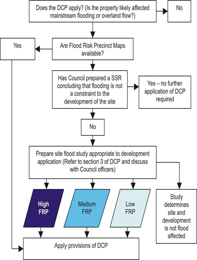
The procedure to determine what controls apply to proposed development involves:
• Schedule 2 identifies the land use category of the development.
• Determine which floodplain and which flood risk precinct the land is located within
(refer to this section and relevant flood risk mapping).
• Apply the controls outlined in Section 3.
• Section 4 identifies special considerations which will apply only to some development in
specific circumstances.
• Section 5 provides controls for fencing in the floodplain.
• Section 6 includes details of schedules identified in Section 3.
Land Use Categories
2.1 Council has adopted eight major land use categories which are identified as:
• Critical uses and facilities
• Sensitive uses and facilities
• Subdivision
• Residential
• Commercial or industrial
• Tourist related development
• Recreation or non–urban uses
• Concessional development.
The specific uses, as defined by the applicable environmental planning instruments,
which may be included in each category, are listed in Schedule 2.
_____________________________________________________________________________
Canterbury Bankstown DCP 2021–Chapter 2.2 Page | 5
DRAFT December 2020Flood Risk Precincts
2.2 Based on the different levels of potential flood risk, each of the floodplains in
Canterbury Bankstown is divided into four categories of flood risk precinct. The relevant
Flood Risk Precincts for each of the floodplains are outlined below.
(a) High flood risk precinct
High Flood Risk Precinct is the area of land below the 100–year flood that is either
subject to a high hydraulic hazard or where there are significant evacuation
difficulties. Most development should be restricted in this precinct as
development in high flood risk precinct is associated with higher risk to life and
evacuation difficulties during the event of flood. In this precinct, there would be a
significant risk of flood damages without compliance with flood related building
and planning controls.
(b) Medium flood risk precinct
Medium Flood Risk Precinct is land below the 100–year flood that is not subject to
a high hydraulic hazard and where there are no significant evacuation difficulties.
There would still be a significant risk of flood damage in this precinct. However,
these damages can be minimised by the application of appropriate development
controls.
(c) Overland flow risk precinct
Overland Flow Risk Precinct is areas of shallow overland flow, typically less than
0.25 metres in depth in a 100–year flood and distant from a recognised
watercourse or major drainage system.
(d) Low flood risk precinct
Low Flood Risk Precinct is defined as all other land within the floodplain (within
the extent of the probable maximum flood) but not identified within either the
High Flood Risk or the Medium Flood Risk Precinct. The risk of damages due to
flood event in low flood risk precinct is low for most of the land uses.
_____________________________________________________________________________
Canterbury Bankstown DCP 2021–Chapter 2.2 Page | 6
DRAFT December 2020SECTION 3–DEVELOPMENT CONTROLS
Explanation
The development controls are graded relative to the severity and frequency of potential
floods, having regard to categories determined by the relevant Floodplain Risk Management
Study and Plan or, if no such study or plan exists, Council’s interim considerations. The
development controls applicable to each floodplain are included within the planning matrices
contained in the following schedules:
• Schedule 3–Georges River Floodplain generally but excluding sections of floodplain
referred to separately.
• Schedules 4A, 4B and 4C–The Carinya Road area. The Carinya Road area has been
excluded from the main schedule applying to the Georges River, as it has always been
considered a special case, as indicated by the fact that this area has been subject to its
own DCP (DCP 9D). As an outcome of the Georges River Floodplain Management Study,
the controls for this area have been reviewed, although in general the controls that
were first included in DCP 9D have largely been retained.
• Schedule 5–Catchments affected by Stormwater Flooding. This schedule defines
development controls for flood liable land in catchments affected by stormwater
flooding. Flood liable land is identified through:
• Council's ongoing flood study and flood risk management process.
• Site specific flood studies, in cases where a flood study or floodplain risk
management plan has not been finalised and adopted by Council.
Where floodplain risk management plans and flood studies are adopted by Council,
maps showing flood liable land will be held in the office of Council.
Note: If a catchment is affected by riverine or stormwater flooding and Council is yet to adopt
a draft floodplain risk management plan or flood study:
• Flood liable land in these catchments will be identified through an ongoing floodplain
risk management process but may also be identified through a site specific flood study.
The habitable floor levels of development are to be a minimum 500mm above the 100–
year flood level.
• All sites in that catchment must be regarded as being flood liable and are defined as a
flood lot for the purposes of the State Environmental Planning Policy (Exempt and
Complying Development Codes) 2008.
_____________________________________________________________________________
Canterbury Bankstown DCP 2021–Chapter 2.2 Page | 7
DRAFT December 2020Objectives
O1 To require development with high sensitivity to flood risk to be designed so that they
are subject to minimal risk.
O2 To allow development with a lower sensitivity to the flood hazard to be located within
the floodplain, provided the risk of harm and damage to property is minimised.
O3 To minimise the intensification of the High Flood Risk Precinct or floodway, and if
possible, allow for their conversion to natural waterway corridors.
O4 To ensure design and siting controls required to address the flood hazard do not result
in unreasonable social, economic or environmental impacts upon the amenity or
ecology of an area.
O5 To minimise the risk to life by ensuring the provision of reliable access from areas
affected by flooding.
O6 To minimise the damage to property (including motor vehicles) arising from flooding.
O7 To ensure the proposed development does not expose existing development to
increased risks associated with flooding.
Development Controls
Performance criteria
3.1 The proposed development should not result in any significant increase in risk to human
life, or in a significant increase in economic or social costs as a result of flooding.
3.2 The proposal should only be permitted where effective warning time and reliable access
is available to an area free of risk from flooding, consistent with any relevant Flood Plan
or flood evacuation strategy.
3.3 Development should not significantly increase the potential for damage or risk other
properties either individually or in combination with the cumulative impact of
development that is likely to occur in the same floodplain.
3.4 Motor vehicles are able to be relocated, undamaged, to an area with substantially less
risk from flooding, within effective warning time.
_____________________________________________________________________________
Canterbury Bankstown DCP 2021–Chapter 2.2 Page | 8
DRAFT December 20203.5 Procedures would be in place, if necessary, (such as warning systems, signage or
evacuation drills) so that people are aware of the need to evacuate and relocate motor
vehicles during a flood and are capable of identifying the appropriate evacuation route.
3.6 To minimise the damage to property, including motor vehicles arising from flooding.
3.7 Development should not result in significant impacts upon the amenity of an area by
way of unacceptable overshadowing of adjoining properties, privacy impacts (e.g. by
unsympathetic house–raising) or by being incompatible with the streetscape or
character of the locality.
Prescriptive controls
3.8 Schedules 3 and 4 outline the controls relevant to each of the floodplains to which
Chapter 2.2 of this DCP applies.
_____________________________________________________________________________
Canterbury Bankstown DCP 2021–Chapter 2.2 Page | 9
DRAFT December 2020SECTION 4–SPECIAL CONSIDERATIONS
Explanation
When assessing proposals for development or other activity within the area to which Chapter
2.2 of this DCP applies, Council will take into consideration the following specific matters:
(a) Proposals for house raising must demonstrate that the raised structure will not be at
risk of failure from the forces of floodwaters and will not result in significant adverse
impacts upon the amenity and character of an area.
(b) Notwithstanding any other provision where a site is identified within a Voluntary
Acquisition Scheme area, Council will only consent to:
(i) development for minor works such as small awnings over existing floor balconies
or in–ground swimming pools; and
(ii) capital investment intended for the property is not greater than the minimum
required to provide an acceptable proposal.
Note: Council will not permit any type of development which would be inconsistent with the
objective of not intensifying further development in areas of high risk and with Council's
commitment to the Voluntary Acquisition Scheme.
Development Controls
Kelso Park, East Hills Levee Floodplain
4.1 This clause applies to land protected by the Kelso Park Levee, East Hills as shown in
Figure 4a.
The Kelso Park Levee was constructed for the purpose of protecting the properties
behind the Levee from flooding from the Georges River. The levee provides protection
for floods at least as high as the 100–year flood. However, some of the properties
protected by the Levee may still be inundated by local stormwater flooding, though to a
lesser degree. This would result from the escape of local stormwater being prevented by
the Levee and the closure of floodgates in the Levee during flooding of the Georges
River, or by levee failure and/ or overtopping in rare events.
Any approval for the erection or extension of a dwelling or other building on land to
which this clause applies shall be accompanied by the following advice: “A Levee known
as the Kelso Park Levee has been constructed for the purpose of protecting this property
and a large number of other properties behind the Levee from flooding from the Georges
River. The Levee could be overtopped in floods greater than the 100 year event”.
_____________________________________________________________________________
Canterbury Bankstown DCP 2021–Chapter 2.2 Page | 10
DRAFT December 2020Figure 4a: Land protected by the Kelso Park Levee in East Hills _____________________________________________________________________________ Canterbury Bankstown DCP 2021–Chapter 2.2 Page | 11 DRAFT December 2020
East Hills Floodplain

4.2   This clause applies to land at East Hills as shown in Figure 4b. All new dwellings, raised
      dwellings, relocated dwelling houses, major additions and dual occupancies shall have
      direct fail–safe pedestrian access to land above the 100–year flood level.

4.3   Notwithstanding 4.2 above, the construction of an external staircase to the street
      boundary will be accepted as satisfactory access for 528 to 558 Henry Lawson Drive for
      new dwellings, dual occupancies, raised dwellings, relocated dwelling houses and major
      additions provided the dwelling stands on the 5.5 metre building line. However, dual
      occupancies will only be permitted where the proposed flood mitigation works have
      been completed and after considering the effectiveness of proposed flood evacuation
      measures.

_____________________________________________________________________________
Canterbury Bankstown DCP 2021–Chapter 2.2                         Page | 12
DRAFT December 2020
Figure 4b: East Hills Floodplain _____________________________________________________________________________ Canterbury Bankstown DCP 2021–Chapter 2.2 Page | 13 DRAFT December 2020
Carinya Road, Picnic Point

4.4   This clause applies to land subject to the high and medium flood risk in the Carinya Road
      area in Picnic Point as shown in Figure 4c.

      (a)   Subdivision and density controls
            (i)  Proposed development must comply with the following residential density
                 controls:
                    Area                          Maximum residential dwelling density
                    East of the boatshed          1 dwelling/ 650m2 of site area
                    West of the boatshed          1 dwelling/ 500m2 of site area

            (ii)   Other development controls for this area are included in Schedules 4B and
                   4C. The controls included in Schedule 4A also apply to this area, and to the
                   land subject to a low flood risk as well.

      (b)   Scenic quality and amenity considerations
            (i)   The maximum height of buildings shall not exceed 9 metres to the topmost
                  point of the structure from the existing ground level below.
            (ii) The relevant flood risk management related development controls are
                  provided in Schedule 4.
            (iii) Where the proposed buildings are required to be elevated, the building
                  needs to be designed to conform with the scale and character of existing
                  development in the area.
            (iv) The design of elevated walkways will need to address: privacy,
                  overshadowing and impact on the scenic quality of the area. The length of
                  the walkways should be minimised by locating dwellings as close as possible
                  to Carinya Road.

      (c)   Prohibited land uses
            (i)  The following specific land uses normally permitted in the residential zone
                 are prohibited within the Carinya Road area shown on Figure 4c: Child care
                 centres, educational establishments, hospitals, residential flat buildings for
                 aged persons not exceeding two storeys, places of assembly, places of public
                 worship, dual occupancies, and seniors housing.

_____________________________________________________________________________
Canterbury Bankstown DCP 2021–Chapter 2.2                         Page | 14
DRAFT December 2020
Figure 4c: Land subject to flood risk in the Carinya Road area in Picnic Point _____________________________________________________________________________ Canterbury Bankstown DCP 2021–Chapter 2.2 Page | 15 DRAFT December 2020
SECTION 5–FENCING

Objectives

O1    To ensure that fencing does not result in the undesirable obstruction of the free flow of
      floodwaters.

O2    To ensure that fencing does not become unsafe during floods so as to threaten the
      integrity of structures or the safety of people.

Development Controls

Performance criteria

5.1   Fencing is to be constructed in a manner which does not significantly increase flood
      damage or risk on surrounding land.

5.2   Fencing shall be certified by a suitably qualified engineer, that the proposed fencing is
      adequately constructed so as to withstand the forces of floodwaters, or collapse in a
      controlled manner to prevent the undesirable impediment of floodwaters.

Prescriptive controls

5.3   All fencing within a High flood risk precinct, and all fencing in other risk precinct that
      obstructs flood flow will require a development application.

5.4   An applicant will need to demonstrate that the fence (new or replacement fence) would
      create no impediment to the flow of floodwaters. Appropriate fences must satisfy the
      following:
      (a) an open collapsible hinged fence structure or pool type fence, or louver fencing;
      (b) other than a brick or other masonry type fence (which will generally not be
            permitted); or
      (c) a fence type and siting criteria as prescribed by Council.

_____________________________________________________________________________
Canterbury Bankstown DCP 2021–Chapter 2.2                         Page | 16
DRAFT December 2020
SECTION 6–SCHEDULES
Schedule 1–Flood Compatible Materials
Building Flood Compatible Material
Component
Doors • solid panel with water proof adhesives
• flush door with marine ply filled with closed cell foam
• painted metal construction
• aluminium or galvanised steel frame
Floor Covering • clay tiles
• concrete, precast or in situ
• concrete tiles
• epoxy, formed–in–place
• mastic flooring, formed–in–place
• rubber sheets or tiles with chemical-set adhesives
• silicone floors formed–in–place
• vinyl sheets or tiles with chemical–set adhesive
• ceramic tiles, fixed with mortar or chemical–set adhesive
• asphalt tiles, fixed with water resistant adhesive
Flooring and • concrete slab–on–ground monolith construction
Sub–floor • suspension reinforced concrete slab
Structure
Insulation • foam (closed cell types)
• aluminium frame with stainless steel rollers or similar corrosion and
Windows water resistant material
Nails, Bolts, • brass, nylon or stainless steel
Hinges and • removable pin hinges
Fittings • hot dipped galvanised steer wire nails or similar
Roofing • reinforced concrete construction
Structure (for • galvanised metal construction
Situations
Where the
Relevant Flood
Level is Above
the Ceiling)
_____________________________________________________________________________
Canterbury Bankstown DCP 2021–Chapter 2.2 Page | 17
DRAFT December 2020Building Flood Compatible Material
Component
Wall Structure • solid brickwork, blockwork, reinforced, concrete or mass concrete
Wall and Ceiling • fibro–cement board
Linings • brick, face or glazed
• clay tile glazed in waterproof mortar
• concrete
• concrete block
• steel with waterproof applications
• stone, natural solid or veneer, waterproof grout
• glass blocks
• glass
• plastic sheeting or wall with waterproof adhesive
_____________________________________________________________________________
Canterbury Bankstown DCP 2021–Chapter 2.2 Page | 18
DRAFT December 2020Building Flood Compatible Material
Component
Ducting All ductwork located below the relevant flood level should be provided
with openings for drainage and cleaning. Self–draining may be achieved
by constructing the ductwork on a suitable grade. Where ductwork must
pass through a watertight wall or floor below the relevant flood level,
the ductwork should be protected by a closure assembly operated from
above relevant flood level.
Electrical and For dwellings constructed on land to which this Policy applies, the
Mechanical electrical and mechanical materials, equipment and installation should
Equipment conform to the following requirements.
Equipment All equipment installed below or partially below the relevant flood level
should be capable of disconnection by a single plug and socket assembly.
Fuel Heating systems using gas or oil as a fuel should have a manually
operated valve located in the fuel supply line to enable fuel cut–off.
Heating and Heating and air conditioning systems should, to the maximum extent
Air possible, be installed in areas and spaces of the house above the
Conditioning relevant flood level. When this is not feasible every precaution should be
Systems taken to minimise the damage caused by submersion according to the
following guidelines.
Installation The heating equipment and fuel storage tanks should be mounted on
and securely anchored to a foundation pad of sufficient mass to
overcome buoyancy and prevent movement that could damage the fuel
supply line. All storage tanks should be vented to an elevation of 600
millimetres above the relevant flood level.
Main power Subject to the approval of the relevant authority the incoming main
supply commercial power service equipment, including all metering equipment,
shall be located above the relevant flood level. Means shall be available
to easily disconnect the dwelling from the main power supply.
Reconnection Should any electrical device and/ or part of the wiring be flooded it
should be thoroughly cleaned or replaced and checked by an approved
electrical contractor before reconnection.
Wiring All wiring, power outlets, switches and the like should, to the maximum
extent possible, be located above the relevant flood level. All electrical
wiring installed below the relevant flood level should be suitable for
continuous submergence in water and should contain no fibrous
components. Earth core linkage systems (or safety switches) are to be
installed. Only submersible–type splices should be used below the
relevant flood level. All conduits located below the relevant designated
flood level should be so installed that they will be self–draining if
subjected to flooding.
_____________________________________________________________________________
Canterbury Bankstown DCP 2021–Chapter 2.2 Page | 19
DRAFT December 2020Schedule 2–Land Use Categories
Critical Uses and Community facilities which may provide an important contribution
Facilities to the notification or evacuation of the community during flood
events; hospitals; nursing homes
Sensitive Uses and Correctional centres; liquid fuel depots; offensive storage
Facilities establishments; seniors housing; telecommunications facilities;
waste disposal facilities; public utility undertakings (including
generating works) which are essential to evacuation during periods
of flood or if affected would unreasonably affect the ability of the
community to return to normal activities after flood events
Subdivision Subdivision of land which involves the creation of new allotments,
with potential for further development
Residential Attached dwellings; bed and breakfast establishments; boarding
houses; camp sites or caravan parks (long–term sites(2) only);
centre–based child care facilities; community facilities (other than
sensitive uses and facilities); dual occupancies; dwellings; dwelling
houses; educational establishments; family day care centres; health
consulting rooms; home based child care; home businesses; home
occupations; group homes; manor houses; multi dwelling housing;
multi dwelling housing (terraces); residential flat buildings;
secondary dwellings; semi–detached dwellings; serviced
apartments; utility installations (other than critical utilities)
Commercial or Amusement centres; business premises; car parks; depots;
Industrial entertainment facilities; freight transport terminals; heliports;
highway service centre; hotel or motel accommodation; industries;
junkyards; light industries; material recycling yards; medical centres;
neighbourhood shops; offensive industries; offensive storage
establishments; office premises; passenger transport terminals;
places of public worship; public administration buildings; pubs;
recreation facilities (major); recreation facilities (indoor); registered
clubs; research stations; restaurants; restricted premises; roadside
stalls; service stations; sex services premises; shops; specialised
retail premises; transport depots; vehicle body repair workshops;
vehicle repair stations; vehicle sales or hire premises; veterinary
hospitals; warehouse or distribution centres
Tourist Related Camp sites or caravan parks (short–term sites(1) only)
Development
_____________________________________________________________________________
Canterbury Bankstown DCP 2021–Chapter 2.2 Page | 20
DRAFT December 2020Recreation or Agriculture; animal boarding or training establishments; boatsheds;
Non–Urban Uses dams; extractive industries; helipads; jetties; marinas; mines;
recreation areas and minor ancillary structures (e.g. toilet blocks or
kiosks/ cafes); recreation facilities (indoor and outdoor) other than
those categorised under ‘commercial or industrial’; plant nurseries;
sanctuaries; swimming pools; turf farming
Concessional Residential development:
Development (i) An addition or alteration to an existing dwelling of not more
than 50m2 to the habitable floor area which existed at the date
of commencement of the former DCP on 5 March 2015;
(ii) The construction of an outbuilding with a maximum floor area
of 30m2; or
(iii) Rebuilt dwellings which substantially reduce flood risk having
regard to property damage and personal safety; or
(iv) A change of use which does not increase flood risk having
regard to property damage and personal safety.
Other developments:
(i) An addition to existing premises of not more than 10% of the
floor area which existed at the date of commencement of the
former DCP on 5 March 2015;
(ii) Rebuilding of a development which substantially reduces the
extent of flood effects to the existing development;
(iii) A change of use which does not increase flood risk having
regard to property damage and personal safety; or
(iv) Subdivision which does not involve the creation of new
allotments with potential for further development.
(1) As defined by the Local Government (Caravan Park and Camping Grounds) Transitional
Regulation 1993.
(2) As defined by the Local Government (Caravan Park and Camping Grounds) Transitional
Regulation 1993.
_____________________________________________________________________________
Canterbury Bankstown DCP 2021–Chapter 2.2 Page | 21
DRAFT December 2020SCHEDULE 3–GEORGES RIVER FLOODPLAIN
Flood Risk Precincts (FRPs)
Low Flood Risk Medium Flood Risk High Flood Risk
Concessional
Concessional
Concessional
Recreation &
Recreation &
Recreation &
Critical Uses
Critical Uses
Critical Uses
Development
Development
Development
Development
Development
Development
Commercial
Commercial
Commercial
Subdivision
Subdivision
Subdivision
Residential
Residential
Residential
& Industrial
& Industrial
& Industrial
Non-Urban
Non-Urban
Non-Urban
& Facilities
& Facilities
& Facilities
Sensitive
Sensitive
Sensitive
Facilities
Facilities
Facilities
Tourist
Tourist
Tourist
Related
Related
Related
Uses &
Uses &
Uses &
Planning Consideration
Floor Level 3 2 2 2 1,6 4,7 2,6,7 5,6,7 2,6,7 1,6 4,7 1,6 4,7
Building Components 2 1 1 1 1 1 1 1
Structural Soundness 3 1 1 1 1 1 1 1
Flood Effects 2 3 3 3 3 3 3 1 2 2 2 2 2 1 1
Car Parking & Driveway Access 1,3,5,6,7 9 9 9 9 9 1,3,5,6,7 1,3,5,6,7 1,3,5,6,7 2,4,6,7 6,7,8 2,4,6,7 6,7,8
Evacuation 2,3,4 7 7 7 7 7 6 2,3 1,3 2,3 4,3 2,3 4,3 2,3
Management & Design 4,5 1 2,3,5 2,3,5 2,3,5 2,3,5 2,3,5 2,3,5
General Notes and Controls COLOUR LEGEND: Not Relevant Potentially Unsuitable Land Use
1 Freeboard equals an additional height of 500mm.
The relevant environmental planning instruments (generally the Local Environmental Plan) identify development permissible with consent in various zones in the LGA. Notwithstanding,
2 constraints specific to individual sites may preclude Council granting consent for certain forms of development on all or part of a site. This matrix identifies where certain development types
will be considered "potentially unsuitable" due to flood risks.
Council can consider a DA for a "potentially unsuitable use" that clearly complies with the objectives of this DCP and with the performance criteria. In this case, prescriptive controls will be
3
applied on a DA specific.
3 Filling of the site, where acceptable to Council, may change the FRP considered to determine the controls applied in the circumstances of individual applications.
Refer to Section 5 of this DCP for planning considerations for proposals involving only the erection of a fence. Any fencing that forms part of a proposed development is subject to the relevant
4
flood effects and structural soundness planning considerations of the applicable land use category.
Terms in italics are defined in the DCP and Schedule 2 specifies development types included in each land use category. These development types are generally as defined within Environmental
5
Planning Instruments applying to the LGA.
From time to time, Council may adopt mapping showing the Boundary of Significant Flow and/or Flood Storage Areas for this floodplain. Refer to Council to find out if these areas have been
6
defined and mapped for this floodplain.
_____________________________________________________________________________
Canterbury Bankstown DCP 2021–Chapter 2.2 Page | 22
DRAFT December 2020Floor Level
1 All floor levels to be no lower than the 20-year flood unless justified by site-specific assessment.
2 Habitable floor levels to be no lower than the 100-year flood level plus freeboard.
3 Habitable floor levels to be no lower than the PMF level. Non-habitable floor levels to be no lower than the PMF level unless justified by a site-specific assessment.
Floor levels to be no lower than the design floor level. Where this is not practical due to compatibility with the height of adjacent buildings, or compatibility with the floor level of existing
4 buildings, or the need for access for persons with disabilities, a lower floor level may be considered. In these circumstances, the floor level is to be a+B46s high as practical and when
undertaking alterations and additions, no lower than the existing floor level.
The level of habitable floor areas to be equal to or greater than the 100-year flood level plus freeboard. If this level is impractical for a development in a Business zone, the floor level should be
5
as high as possible.
6 Non-habitable floor levels to be no lower than the 20-year flood unless justified by site-specific assessment.
A restriction is to be placed on the title of the land, pursuant to S.88B of the Conveyancing Act, where the lowest habitable floor area is elevated more than 1.5m above finished ground level,
7
confirming that the undercroft area is not to be enclosed. The use of roller shutters or similar measures (such as hit and miss brickwork) to enclose this area is however permissible.
Building Components & Method
1 All structures to have flood compatible building components below the 100-year flood level plus freeboard.
2 All structures to have flood compatible building components below the PMF level.
Structural Soundness
1 Engineer's report to certify that the structure can withstand the forces of floodwater, debris and buoyancy up to and including a 100-year flood plus freeboard.
Applicant to demonstrate that the structure can withstand the forces of floodwater, debris and buoyancy up to and including a 100-year flood plus freeboard. An engineer's report may be
2
required.
3 Applicant to demonstrate that any structure can withstand the forces of floodwater, debris and buoyancy up to and including a PMF. An engineer’s report may be required.
Flood Effects
Engineer's report required to certify that the development will not increase flood effects elsewhere, having regard to: (i) loss of flood storage; (ii) changes in flood levels and velocities caused
1
by alterations to the flood conveyance; and (iii) the cumulative impacts of multiple developments in the floodplain.
The flood impact of the development to be considered to ensure that the development will not increase flood effects elsewhere, having regard to: (i) loss of flood storage; (ii) changes in flood
2
levels and velocities caused by alterations to the flood conveyance and (iii) the cumulative impacts of multiple potential developments in the floodplain. An engineer’s report may be required.
Flood impacts to be considered in the case of major development if Council advise that the development may generate flood impact, such as significant loss of storage or conveyance. Any
3
assessment may also be asked to demonstrate that the proposed development is structurally sound.
Note: (1) If a Boundary of Significant Flow has been defined for this floodplain, any development inside this area will normally be unacceptable as it will reduce flood conveyance and increase flood
effects elsewhere. (2) If a Flood Storage Area has been defined for this floodplain any filling of the floodplain inside this area (except where this occurs by compensatory evacuation), will normally be
unacceptable as it will reduce the volume of flood storage available on the floodplain and increase flood effects elsewhere. (3) Even where a boundary of significant flow and or a storage area have
been identified, developments outside these areas may still increase flood impacts elsewhere and therefore be unacceptable.
Car Parking and Driveway Access
The minimum surface level of open car parking spaces or carports shall be as high as practical, but no lower than the 20-year flood or the level of the crest of the road at the location where the
1
site has access. In the case of garages, the minimum surface level shall be as high as practical, but no lower than the 20-year flood.
2 The minimum surface level of open car parking spaces, carports or garages, shall be as high as practical.
Garages capable of accommodating more than 3 motor vehicles on land zoned for urban purposes, or enclosed car parking, must be protected from inundation by floods up to the 100-year
3
flood.
4 The driveway providing access between the road and parking space shall be as high as practical and generally rising in the egress direction.
_____________________________________________________________________________
Canterbury Bankstown DCP 2021–Chapter 2.2 Page | 23
DRAFT December 2020The level of the driveway providing access between the road and parking space shall be no lower than 0.3m below the 100-year flood or such that the depth of inundation during a 100-year
5 flood is not greater than either the depth at the road or the depth at the car parking space. A lesser standard may be accepted for single detached dwelling houses where it can be demonstrated
that risk to human life would not be compromised.
Enclosed car parking and car parking areas accommodating more than 3 vehicles (other than on Rural zoned land), with a floor level below the 20-year flood or more than 0.8m below the 100-
6
year flood level, shall have adequate warning systems, signage and exits.
7 Restraints or vehicle barriers to be provided to prevent floating vehicles leaving a site during a 100-year flood.
Driveway and parking space levels to be no lower than the design ground/floor levels. Where this is not practical, a lower level may be considered. In these circumstances, the level is to be as
8
high as practical, and, when undertaking alterations or additions, no lower than the existing level.
9 Flood related parking and access requirements to be advised by Council if necessary. Contact Council for advice as early as possible.
Note: (1) A flood depth of 0.3m is sufficient to cause a typical vehicle to float. (2) Enclosed car parking is defined in the DCP and typically refers to carparks in basements.
Evacuation
1 Reliable access for pedestrians or vehicles required during a 100-year flood.
2 Adequate flood warning is available to allow safe and orderly evacuation without increased reliance upon the SES or other authorised emergency services personnel.
3 The development is to be consistent with any relevant flood evacuation strategy, Flood Plan adopted by Council or similar plan.
The evacuation requirements of the development are to be considered. A report from a suitably qualified and experienced person will be required if circumstances are possible where the
4
evacuation of persons might not be achieved within the effective warning time.
5 Reliable access for pedestrians or vehicles required to a publicly accessible location above the PMF.
6 Applicant to demonstrate that evacuation in accordance with the requirements of this DCP is available for the potential development flowing from the subdivision proposal.
7 Evacuation requirements to be advised by Council if necessary. Contact Council for advice as early as possible.
Management and Design
1 Applicant to demonstrate that potential development as a consequence of a subdivision proposal can be undertaken in accordance with this DCP.
2 Site Emergency Response Flood Plan required where floor levels are below the design floor level, (except for single dwelling-houses).
3 Applicant to demonstrate that area is available to store goods above the 100-year flood level plus freeboard.
4 Applicant to demonstrate that area is available to store goods above the PMF level.
5 No storage of materials below the design floor level which may cause pollution or be potentially hazardous during any flood.
_____________________________________________________________________________
Canterbury Bankstown DCP 2021–Chapter 2.2 Page | 24
DRAFT December 2020SCHEDULE 4A–CARINYA ROAD, PICNIC POINT FLOODPLAIN
Planning and Development Controls
Flood Risk Precincts (FRP's)
Low Flood Risk Medium & High
Flood Risk
Residential (outbuildings eg.
Residential (outbuildings eg.
Concessional Development
Concessional Development
concessional development)
concessional development)
Residential (house raising)
Residential (house raising)
Sensitive Uses & Facilities
Sensitive Uses & Facilities
Garages, carports, garden
Garages, carports, garden
Residential (alterations &
Residential (alterations &
Recreation & Non-Urban
Recreation & Non-Urban
sheds, swimming pools)
sheds, swimming pools)
Critical Utilities & Uses
Critical Utilities & Uses
including new & rebuilt
including new & rebuilt
Residential (General
Residential (General
additions other than
additions other than
Subdivision
Subdivision
dwellings)
dwellings)
Planning
Consideration
Floor Level 3 6 2,5 2 2,4 6 2,5 2 2 5 1 2 or 4
Building Components 2 1 1 1 1 1 1 1 1 1
Structural Soundness 3 2 1 1 1 1#,2 2 1#,2
Flood Affectation 2 2 2,3 2 1 2,3 1,3 1,3 1,3 2 1,3
Evacuation 3,5 1,2 * 1,2,4 1,4 1,2 * 1,2,4 1#,4 1,4 3,4
Management & Design 4,5 1,7 1,7 2,3,5,6,7,8 2,5,6,7,8 2,5,6,8 5,6 2,3,5 3,5,8
Not Relevant Potentially Unsuitable Land Use
Note: 1.Filling of the site, where acceptable to Council, may change the FRP considered to determine the
Freeboard equals an additional height of 500mm
controls applied in the circumstances of individual applications.
2. Terms in italics are defined in the glossary of this plan and Schedule 2 specifies development types
Refer to 'Management & Design' planning
* consideration for subdivision
included in each land use category. These development types are generally as defined within
Environmental Planning Instruments applying to the local go
# Desirable but not mandatory. Will be considered 3. Alterations & additions (except concessional development) are not permitted for existing dwellings which
by Council on the merits of each application have habitable floor areas below the 100 year flood level plus 0.5m freeboard .
4. The relevant environmental planning instruments (generally the Local Environmental Plan) identify
development permissible with consent in various zones in the LGA. Notwithstanding, constraints specific to
individual sites may preclude Council granting
Floor Level
1 All Floor Levels to be equal to or greater than the 20 year flood level plus freeboard unless justified by site specific assessment
2 Habitable floor levels to be equal to or greater than the 100 year flood level plus freeboard
3 All Floor Levels to be equal to or greater than the PMF flood level plus freeboard
4
Floor levels to be as close to the design floor level as practical & no lower than the existing floor level when undertaking alterations or additions
On allotments west of the boat shed with vehicle access to Carinya Road, which have new or additional dwellings constructed after the date of commencement of this Plan,
5
garages/carports/carspaces/driveways to have ground/floor levels equal to or greater t
6 Restrictions to be placed on title advising of minimum floor levels required relative to flood level.
Building Components & Method
1 All structures to have flood compatible building components below or at the 100 year flood level plus freeboard
2 All structures to have flood compatible building components below or at the PMF level plus freeboard
Structural Soundness
1 Engineers report to certify that any structure can withstand the forces of floodwater, debris & buoyancy up to & including a 100 year flood plus freeboard
2 Applicant to demonstrate that any structure can withstand the forces of floodwater, debris & buoyancy up to & including a 100 year flood plus freeboard
3 Applicant to demonstrate that any structure can withstand the forces of floodwater, debris & buoyancy up to & including a PMF flood plus freeboard
Flood Effects
Engineers report required to certify that the development will not increase flood effects elsewhere, if proposed filling covers more than 200sq.m and extends more than 25m from the Carinya Road
1
frontage.
2 The impact of the development on flooding elsewhere to be considered
3 Limited filling will be considered for new dwellings in the area between new dwellings/garages and Carinya Road
Note: When assessing flood effects the following must be considered:
1. Loss of storage area in the floodplain
2. Changes in flood levels & velocities caused by alteration of conveyance of flood waters
Evacuation
1 Reliable and failsafe access for pedestrians required at or above the 100 year flood level, and not more than 0.5m below the highest floor level. This access is to be adjacent the side boundary.
Granting a R.O.W. to the adjoining owner is encouraged. In t
Reliable and failsafe access for vehicles (eg. garage, carport, driveway or carsoace) required at or above the 100 year flood level for allotments with frontage to Carinya Road and west of the boat
2 shed, which have new or additional dwellings constructed
3 Reliable access for pedestrians and vehicles required during a PMF flood
4 The development is to be consistent with any relevant flood evacuation strategy or similar plan
Management and Design
1 Applicant to demonstrate that potential development as a consequence of a subdivision proposal can be undertaken in accordance with this Plan
2 Site Emergency Response Flood plan required.
3 Applicant to demonstrate that area is available to store goods above the 100 year flood level plus freeboard
4 Applicant to demonstrate that area is available to store goods above the PMF level plus freeboard
5 No external storage of materials below the 100 year flood level plus freeboard, which may cause pollution or be potentially hazardous during a flood
_____________________________________________________________________________
Canterbury Bankstown DCP 2021–Chapter 2.2 Page | 25
DRAFT December 2020SCHEDULE 4B–CARINYA ROAD, PICNIC POINT FLOODPLAIN:
Compilation of Development Controls for Residential Development
Type of Development Requirements
1. Additions to an existing dwelling whose floor • Habitable floor area extensions
level is already raised at least 0.5m above the permitted at or above 100- year
100 year flood level flood level plus 0.5m.
• Non-habitable floor area
extensions permitted below 100-
year flood level plus 0.5m.
• Outbuildings (garages, carports,
sheds) permitted below the 100-
year flood level, except for
garages, driveways, carports, etc.
on allotments west of the boat
shed, with frontage to Carinya
Road. Refer to Section below.
• Failsafe pedestrian access
(walkways and stairs) encouraged
but not mandatory.
• Failsafe vehicular access
(driveways and car space) generally
encouraged but not mandatory.
However, new or improved
garages, carports, driveways, car
spaces, etc. on allotments west of
the boat shed and with frontage to
Carinya Road, must have
ground/floor levels at or above the
100-year flood level.
• Construction methods for non-
habitable areas used below the
100-year flood level plus 0.5m
must preclude the area from being
converted into a habitable room.
Acceptable methods include single
brick walls with roller shutter doors
at opposite sides, lattice walling
and the like. These construction
methods will also assist in reducing
damage during floods and will
_____________________________________________________________________________
Canterbury Bankstown DCP 2021–Chapter 2.2 Page | 26
DRAFT December 2020You can also read