Wyong River Catchment Floodplain Risk Management Study & Draft Plan - Summary Report - Draft Wyong River Floodplain Risk ...
←
→
Page content transcription
If your browser does not render page correctly, please read the page content below
Wyong River Catchment Floodplain Risk
Management Study & Draft Plan
Summary Report

  Revision 3
  January 2019

                  i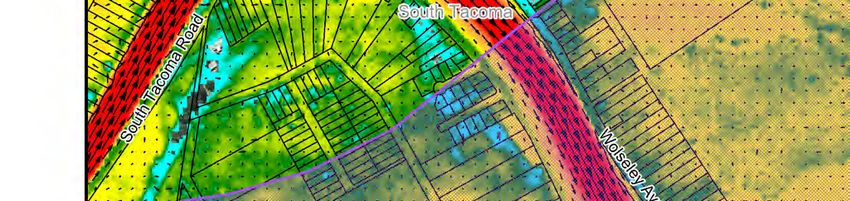
ii

TABLE OF CONTENTS
1   INTRODUCTION.......................................................................................................... 1
    1.1 Report Structure ................................................................................................. 1
2   THE EXISTING FLOODING PROBLEM .................................................................. 2
    2.1 Overview .............................................................................................................. 2
    2.2 Summary of Flooding Impacts ......................................................................... 2
        2.2.1 Yarramalong Valley .....................................................................................2
        2.2.2 Dooralong Valley .........................................................................................2
        2.2.3 Mardi Rural Residential ..............................................................................3
        2.2.4 Mardi Urban ..................................................................................................3
        2.2.5 Tuggerah Straight Industrial ......................................................................3
        2.2.6 Wyong West of Pacific Highway ...............................................................4
        2.2.7 Wyong East of Pacific Highway ................................................................4
        2.2.8 Tacoma .........................................................................................................4
        2.2.9 South Tacoma ..............................................................................................5
        2.2.10 Tuggerah Residential ..................................................................................5
    2.3 The Cost of Flooding ......................................................................................... 5
    2.4 Summary of Flooding “Trouble Spots” ............................................................ 6
3   OPTIONS FOR MANAGING THE FLOOD RISK ................................................... 7
    3.1 General ................................................................................................................ 7
    3.2 Potential Options for Managing the Flooding Risk ....................................... 7
    3.3 Flood Modification Options ............................................................................... 8
        3.3.1 Detention Basins..........................................................................................8
        3.3.2 Levees ...........................................................................................................9
        3.3.3 Channel Modifications ................................................................................9
        3.3.4 Drainage Upgrades ...................................................................................14
    3.4 Property Modification Options ........................................................................ 16
        3.4.1 Voluntary House Purchase ......................................................................16
        3.4.2 Voluntary House Raising ..........................................................................16
        3.4.3 Voluntary Flood Proofing ..........................................................................17
        3.4.4 Wyong Aged Care Facility Modifications ...............................................17

                                                                iii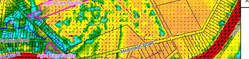
3.4.5 Planning Revisions ....................................................................................18
    3.5 Response Modification Options ..................................................................... 18
        3.5.1 Local Flood Plan Updates ........................................................................18
        3.5.2 Flood Intelligence Card Updates.............................................................19
        3.5.3 Community Education...............................................................................19
        3.5.4 Emergency Response Plans ...................................................................22
        3.5.5 Options to Improve Emergency Response During a Flood ................24
    3.6 Options to Aid in Post-Flood Recovery......................................................... 26
        3.6.1 Recovery Planning ....................................................................................26
        3.6.2 Flood Insurance .........................................................................................26
        3.6.3 Disaster Relief ............................................................................................27
4   DRAFT FLOODPLAIN RISK MANAGEMENT PLAN ........................................... 28
    4.1 Introduction ....................................................................................................... 28
    4.2 Recommended Options .................................................................................. 28
    4.3 Plan Implementation ........................................................................................ 28
        4.3.1 Costs and Funding ....................................................................................28
        4.3.2 Review of Plan ...........................................................................................29
5   GLOSSARY ................................................................................................................ 37
6   REFERENCES ........................................................................................................... 44

        LIST OF TABLES
Table 1       Summary of Flood Damage Costs for Existing Conditions ...................................6
Table 2       Flood Risk Management Options Adopted for Detailed Investigation ...................8
Table 3       Draft Wyong River Catchment Floodplain Risk Management Plan .....................30

                                                               Eiv
1      INTRODUCTION
The Wyong River catchment is located on the Central Coast of New South Wales and occupies
a total area of 440 km2. The catchment is drained by a network of rivers and creeks including
the Wyong River, Cedar Brush Creek, Jilliby Jilliby Creek, Porters Creek, Mardi Creek and Deep
Creek that ultimately drain into Tuggerah Lake. Tuggerah Lake, in turn, discharges to the
Pacific Ocean via a single outlet at The Entrance.

During periods of heavy rainfall within the catchment, there is potential for water to overtop
the banks of the various watercourses and inundate the adjoining floodplain. The catchment
has a long history of flooding including significant events in 1949, 1964 and 1977 as well as
more recently in 2007.

In recognition of the flooding problems confronting the Wyong River catchment, Central Coast
Council commisioned Catchment Simulation Solutions to prepare a Floodplain Risk
Management Study and Plan for the catchment. The primary goal of the project was to
quantify the nature and extent of the existing flooding problem and evaluate options that
could be potentially implemented to manage the existing, future and continuing flood risk.

The Floodplain Risk Management Study & Plan comprises two primary documents:
    Volume 1: contains the report text and appendices;
    Volume 2: contains all figures and maps.

The intent of this Summary Report is to provide a concise summary of the key findings of the
study and plan in a single document.

1.1 Report Structure
The following summary report has been divided into the following sections:
    Section 2 – The Existing Flood Risk: describes the current impact of flooding on the
    community for a range of different floods.
    Sections 3 – Flood Risk Management Options: discusses the merits of a range of flood,
    property and response modification measures that could be potentially implemented to
    manage the flood risk across the catchment
    Section 4 – Draft Floodplain Risk Management Plan: provides a preferred list of options
    that are considered appropriate for adoption by Council to manage the flood risk.
    Section 5 – Glossary: provides an alphabetical list of technical terms used in the report
    and definitions of each term.

                                              1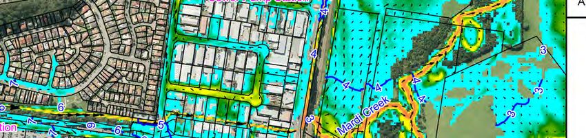
2 THE EXISTING FLOODING PROBLEM
2.1 Overview
The nature and extent of the existing flood risk was quantified using a computer flood models
of the Wyong River catchment. The flood models were used to simulate range of “design”
floods (hypothetical floods that are defined based upon their probability of occurrence). This
included the 20% Annual Exceedance Probability (AEP) flood as well as the 5% AEP, 1% AEP
and Probable Maximum Floods (PMF). The PMF is the largest flood that could possibly occur.
The results of each design flood were extracted and used to prepare a range of flood maps.
The flood maps show peak floodwater levels, depths and velocities. The full list of figures is
provided in Volume 2 of the Floodplain Risk Management Study.
The results of the flood modelling were also used to prepare flood hazard mapping. The flood
hazard mapping shows the potential impact that floodwaters would likely have on people,
buildings and vehicles. Flood emergency response classifications where also prepared to
identify the types of emergency response that may be required across different sections of
the catchment and to identify locations where roadways would be cut by floodwaters.
The following sections summarise the outcomes of the existing flood assessment across
different sections of the Wyong River catchment. The discussion is broken down into different
catchment “sectors”.
2.2 Summary of Flooding Impacts
2.2.1 Yarramalong Valley
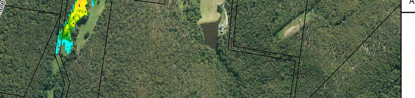
The Yarramalong Valley is a large sector extending from the upper reaches of the floodplain
in Cedar Brush Creek and Ravensdale, past Yarramalong village to the eastern limit of Wyong
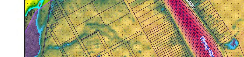
Creek where it meets Wyong and Mardi. Figure A3.8 on the following page shows peak 1%
AEP floodwater depths, levels and velocities in the vicinity of Yarramalong village.
An estimated 49 dwellings in this sector are predicted to be flooded above floor in the 1% AEP
event, although most of these have a second storey that could provide a means of reducing
damages to contents. While roads are flooded very early cutting access within the valley and
to Wyong, most housing is located beyond the floodplain or towards the edge of the floodplain
with access to higher ground by foot if not by road or track. But there are some exceptions
where access is lost prior to inundation of the house footprint. Plus, for people who do
evacuate to higher ground, the duration of isolation is considerable.
2.2.2 Dooralong Valley
The Dooralong Valley sector extends from the upper reaches of Jilliby Jilliby Creek’s floodplain
in Lemon Tree, through Dooralong and Jilliby to the Wyong River. Peak 1% AEP floodwater
depths, levels and velocities in the vicinity of Dooralong village are provided in Figure A3.17.
2
Wyong River Catchment
Floodplain Risk Management Study & Plan
Summary Report
Compared to the Yarramalong Valley, significantly fewer existing houses are estimated to be
flooded above floor level for both the 1% AEP and PMF events. But the same problems of very
limited warning and lengthy disruption to access prevail.
2.2.3 Mardi Rural Residential
The ‘Mardi rural’ sector includes rural residential properties along Old Maitland Road, Collies
Lane, McPherson Road (including the Wyong Aged Care Facility) and Mardi Road. Peak 1%
AEP floodwater depths, levels and velocities for this area are provided in Figure A3.24.
Even in the 1% AEP event, this area has a significant flood risk, with 27 dwellings flooded above
floor and with evacuation routes likely to be flooded even before a formal flood warning is
issued. This means that evacuation would need to commence based on another trigger such
as issuance of a Flood Watch or Severe Weather Warning.
Of particular concern for these properties is the high flood hazard experienced at most
dwellings in this area in the PMF, which could threaten building integrity as well as make it
unsafe to seek on-site refuge. And this event provides even more of a warning time deficit
because the floodwater would rise very rapidly.
The Wyong Aged Care Facility is particularly susceptible to inundation. More specifically,
access would be cut, and inundation of the property is predicted during each of the design
flood events (however, above floor inundation is not anticipated until the 1% AEP event).
Access to the aged care facility would be cut before inundation of the property occurs.
2.2.4 Mardi Urban
The ‘Mardi urban’ sector includes land in Mardi zoned for residential use. Peak 1% AEP
floodwater depths, levels and velocities for this area are shown in Figure A3.26.
Its flood exposure is relatively modest, with no dwellings anticipated to flood over floor in the
1% AEP event. Access via Woodbury Park Drive to Wyong Road during the 1% AEP flood is
subject to negligible disruption by floodwaters from Mardi Creek.
In the PMF, a large number of houses on the eastern side of the suburb would be flooded over
floor, though not to depths and velocities expected to threaten dwelling integrity. Access to
the suburb would be lost very early in such a flood and would continue for 21 hours at
Woodbury Park Drive near Wyong Road.
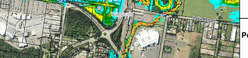
2.2.5 Tuggerah Straight Industrial
The Tuggerah Straight industrial area contains about 238 industrial buildings, 64 of which are
flooded above floor in the 1% AEP event and 210 in the PMF. Peak 1% AEP floodwater depths,
levels and velocities for this area are shown in Figure A3.26.
In the PMF, 68 buildings are subject to H5 hazard conditions and seven to H6 hazard
conditions, which could threaten buildings’ structural integrity. Some warning time (up to 6.5
3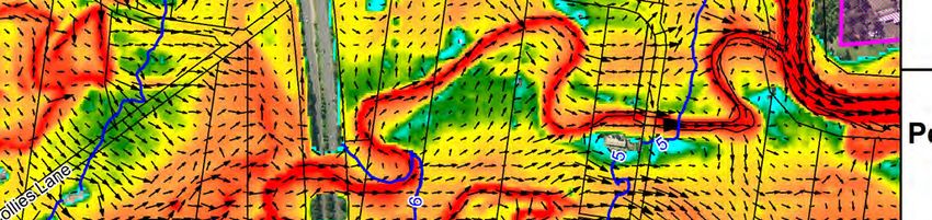
Wyong River Catchment
                                                   Floodplain Risk Management Study & Plan
                                                                          Summary Report

hours) could be available for the evacuation of assets and personnel towards the Pacific
Highway in the 1% AEP event, but not in the PMF.

2.2.6   Wyong West of Pacific Highway
The ‘Wyong west’ sector extends between the Pacific Motorway and the Pacific Highway. It
includes houses in the main urban area of Wyong fronting the Wyong River, as well as houses
along Alison Road west of Porters Creek bridge. Peak 1% AEP floodwater depths, levels and
velocities for this area are provided in Figure A3.27.

Relatively few dwellings are flooded over floor in the 1% AEP event. All buildings that are
inundated above floor level are located along Alison Road, which can be cut at Porters Creek
before a formal flood warning is issued. Provided evacuation commences before flooding,
these houses generally have rising road access towards the Pacific Motorway.

The flood height range between the 1% AEP flood level and the PMF level is at a maximum
between the Pacific Motorway and Pacific Highway, reaching about 3.75m at some houses
along Alison Road west of Porters Creek. As a consequence, the hydraulic hazard in the PMF
is high, reaching H5 at 25 dwellings and H6 at 8 dwellings. This degree of hazard could
threaten building integrity, making it unsafe for on-site refuge, even if floor space above the
PMF were available.

2.2.7   Wyong East of Pacific Highway
The ‘Wyong east’ sector extends from the Pacific Highway to the eastern end of McDonagh
Road. Peak 1% AEP floodwater depths, levels and velocities for this area are provided in Figure
A3.27.

A large number of dwellings are predicted to be flooded above floor level in the 1% AEP event,
but not to depths/velocities expected to threaten the structural integrity of standard
buildings, and a short window should be available for people’s evacuation.

In the PMF about 400 dwellings are estimated to be flooded above floor level, and H5 hazard
conditions would be experienced at about half of these, indicative of the likelihood of
structural damage or even failure. In such a fast-rising flood, roads could be cut before a
formal flood warning is issued.

2.2.8   Tacoma
Peak 1% AEP floodwater depths, levels and velocities for Tacoma are provided in Figure A3.28.
Tacoma includes an estimated 78 dwellings subject to above floor flooding in the 1% AEP
event. Fortunately, some warning time may be available for evacuation prior to the loss of
evacuation routes in this design event.

In the PMF, almost all dwellings on the floodplain would be flooded above floor level, about
18 would be subject to H5 hazard conditions (these are mainly located along Wolseley Avenue
west of Hillcrest Avenue) and roads could be cut before a formal flood warning is issued. Once
roads are cut, a significant period of isolation is anticipated (1–1½ days from Wyong River

                                              4
Wyong River Catchment
Floodplain Risk Management Study & Plan
Summary Report
flooding, but potentially longer if affected by flooding from Tuggerah Lake, and with a loss of
sewerage service).
2.2.9 South Tacoma
The South Tacoma sector includes 97 dwellings, 53 of which are subject to above floor flooding
in the 1% AEP event. Peak 1% AEP floodwater depths, levels and velocities for South Tacoma
are provided in Figure A3.28.
Evacuation in advance of flooding is difficult because South Tacoma Road is flooded at ~1.2m
AHD as it passes under the Pacific Highway and railway bridges. Even though the Bureau
provides six hours’ warning of minor floods, egress could still be lost 3½ hours before the
warning is issued, making early evacuation difficult.
2.2.10 Tuggerah Residential
Peak 1% AEP floodwater depths, levels and velocities for the Tuggerah residential area are
shown in Figure A3.29.
Relatively few houses are located in Tuggerah, mostly in Lake Road. Only two of these
buildings, located at the eastern end of Lake Road, are estimated to be flooded over floor in
the 1% AEP event, and in this event, these have a relatively long time before access is cut,
which should allow time for evacuation.
In the PMF, 12 houses would be flooded over floor, including four single-storey houses to
depths >1.2m that would oblige the residents to evacuate.
2.3 The Cost of Flooding
To assist in quantifying the financial impacts of flooding on the community, a flood damage
assessment was completed. The flood damage assessment aimed to quantify the potential
flood damage costs incurred to private and public property during a range of design floods
across the Wyong River catchment.
The final flood damage estimates for each design flood are summarised in Table 1 for existing
topographic and development conditions. It indicates that if a 1% AEP flood was to occur,
over $80 million worth of damage could be expected. Approximately half of that damage cost
would be incurred across residential property.
The damage estimates were also used to prepare an Average Annual Damage (AAD) estimate
for each property. The AAD takes into consideration the frequency of a particular event
occurring and the damage incurred during that event to estimate the average damage that is
likely to occur each year, on average. The AAD for the Wyong River catchment was
determined to be $4.3 million. Accordingly, if the “status quo” was maintained, residents and
business owners within the catchment as well as infrastructure providers, such as Council,
would likely be subject to cumulative flood damage costs of approximately $4.3 million per
annum (on average).
5Wyong River Catchment
Floodplain Risk Management Study & Plan
Summary Report
Table 1 Summary of Flood Damage Costs for Existing Conditions
Flood Damages ($ millions)
Flood Event Commercial/
Residential Infrastructure Total Damages
Industrial
20% AEP 0.62 0.00 0.09 0.71
10% AEP 2.82 0.44 0.49 3.75
5% AEP 14.28 5.91 3.03 23.2
2% AEP 31.8 14.3 6.91 53.0
1% AEP 48.7 28.6 11.6 88.9
0.5% AEP 60.5 52.4 16.9 130
PMF 213 239 67.8 520
2.4 Summary of Flooding “Trouble Spots”
The information generated as part of the computer flood modelling indicates that the
following areas are likely to experience significant property damage, risk to life and/or
evacuation difficulties during floods within the Wyong River catchment:
Yarramalong valley
Rural residential properties located in the vicinity of Deep Creek including Yarramalong
Road, Old Maitland Road, Collies Lane, McPherson Road and Mardi Road.
The Tuggerah straight industrial area
Properties in the vicinity of South Tacoma and Tacoma.
Properties in Wyong adjoining Panonia Road and Boyce Avenue
The Wyong Aged Care facility
63 OPTIONS FOR MANAGING THE FLOOD RISK
3.1 General
As outlined in Section 2, a number of properties within the Wyong River catchment are
predicted to be exposed to a significant flood risk and/or significant financial impacts during
floods within the catchment. Accordingly, the following chapter outlines options that were
investigated to better manage the existing flood risk across the catchment.
3.2 Potential Options for Managing the Flooding Risk
Options for managing the flood risk can be broadly grouped into one of the following
categories:
Flood Modification Options: are measures that aim to modify existing flood behaviour,
thereby, reducing the extent, depth and velocity of floodwater across flood liable areas.
Flood modification measures will generally benefit a number of properties and are
primarily aimed at reducing the existing flood risk.
Property Modification Options: refers to modifications to planning controls and/or
modifications to individual properties to reduce the potential for inundation in the first
instance or improve the resilience of properties should inundation occur. Modifications
to individual properties is typically used to manage existing flood risk while planning
measures (e.g., land use/development controls) are employed to manage future flood
risk.
Response Modification Options: are measures that can be implemented to change the
way in which emergency services as well as the public responds before, during and after
a flood. Response modification measures are the key measures employed to manage
the continuing flood risk.
The options listed in Table 2 were ultimately selected for detailed assessment as part of the
study.
A summary of the outcomes of the options evaluation are provide in Section 3.3 (flood
modification options), Section 3.4 (property modification options) and Section 3.5 (response
modification options).
7Wyong River Catchment
Floodplain Risk Management Study & Plan
Summary Report
Table 2 Flood Risk Management Options Adopted for Detailed Investigation
Property Modification Response Modification
Flood Modification Options
Options Options
Mardi Creek Detention Basin Updates to DCP Flood Education
Anzac Road Flood Gates Voluntary flood proofing Upgrade flood warning system
Install flood gates at road
Mardi Creek floodway Voluntary house raising
overtopping points
Voluntary house purchase of
South Tacoma relief floodway Local flood plan updates
select properties
Lower floodplain maintenance / Private flood plans for Tuggerah
clearing industrial area
Mardi Creek debris control Improve flood access for South
structures Tacoma
Pacific Highway / Pacific
Improve flood access along
Motorway debris control
Yarramalong Road
structures
Improve flood access along
Tuggerah Lake Entrance dredging
McPherson Road
Wyong River dredging
Main northern railway culvert
upgrades
Floodgates on drainage pipes to
Wyong River
3.3 Flood Modification Options
3.3.1 Detention Basins
Mardi Creek Detention Basin
Recommendation: Further detailed feasibility assessment recommended.
This option would involve construction of a flood detention basin on Mardi Creek upstream of
the Pacific Motorway. A concept design for the basin is shown in Figure B1.
It is expected the basin would cost approximately $440,000 to implement and maintain.
The results of revised flood modelling showed that the detention basin is predicted to reduce
existing flood levels and extents along Mardi Creek as well as adjoining floodplain areas during
both the 20% AEP and 1% AEP floods. In general, flood level reductions are typically around
0.1 metres in the vicinity of Anzac Road and Ace Crescent.
The outcomes of a revised flood damages assessment estimates that the detention basin
would reduce flood damage costs by $770,000 over the 50-year design life of the basin. This
yielded a preliminary benefit-cost ratio of 1.75. Accordingly, the financial benefits of
implementing the basin outweigh the costs.
8MAP!1
LEGEND
Gross Pollutant Trap
Culvert
Basin Wall
Spillway
Detention Basin
Access Roadway
Notes:
Scale 1:8,000 (at A3)
0 0.25 0.5
Km
Figure B1:
Conceptual Layout
for Mardi Creek
Detention Basin
Prepared By:
Suite 2.01, 210 George St
Sydney, NSW 2000
File Name: B1 Figure Conceptual Layout
Mardi Ck Detention Basin.worWyong River Catchment
Floodplain Risk Management Study & Plan
Summary Report
Overall, the Mardi Creek detention basin appears to afford some significant benefits.
However, further investigations are recommended to confirm the feasibility of this option.
This should include a flora/fauna impact assessment and Aboriginal Heritage Assessment.
3.3.2 Levees
Anzac Road Levee and Flood Gates
Recommendation: Recommended for implementation.
The Tuggerah industrial area is predicted to be subject to frequent inundation from Mardi
Creek as well as the Wyong River. In particular, Anzac Road is low lying and susceptible to
flooding from “backwater” inundation from Mardi Creek. Therefore, Council requested that
a levee embankment across a “feeder” channel adjoining Anzac Road be investigated to
reduce the potential for floodwaters “backing up” from the Mardi Creek channel and
inundating properties located near the McDonalds and Hungry Jack’s restaurants. A concept
design for the levee is provided in Figure C1.
It is expected that the levee and gated culvert would have a total implementation cost about
$150,000.
The results of revised hydraulic modelling with the levee in place showed that inundation
would be prevented during the 20% AEP flood. Accordingly, significant benefits are predicted
during frequent floods. Flood level reductions of around 0.1 metres are also predicted during
the 1% AEP flood
A revised damages assessment was also completed based on the results of the revised flood
simulations. This determined that implementation of the levee would reduce flood damage
costs by approximately $60,000 over the projected life of the levee system (i.e., 50 years).
This yields a preliminary BCR of 0.37. Therefore, the costs of implementing the option are
predicted to outweigh the reductions in flood damage costs. Nevertheless, the relatively low
capital and ongoing costs and the financial benefits of businesses being exposed to less
frequent inundation may be sufficient financial evidence to support the option.
It is recommended that construction of the levee is pursued.
3.3.3 Channel Modifications
Mardi Creek Relief Floodway
Recommendation: Not recommended for implementation
The Mardi Creek relief floodway would aim to provide an additional flow path starting near
the Mardi Creek channel east of the Pacific Highway, through the existing railway
embankment and re-joining Mardi Creek east of the railway line. Key features of the floodway
are shown in Figure D1.
9MAP!1
LEGEND
Gross Pollutant Trap
Culvert
Levee Wall
Notes:
Scale 1:1,000 (at A3)
0 25 50
m
Figure C1:
Conceptual Layout
for Anzac Road Levee
Prepared By:
Suite 2.01, 210 George St
Sydney, NSW 2000
File Name: C1 Figure Conceptual Layout
for Anzac Road Levee.worMAP!1
LEGEND
Culvert
Relief Floodway
Notes:
Scale 1:2,000 (at A3)
0 50 100
m
Figure D1:
Conceptual Layout
for Mardi Creek
Relief Floodway
Prepared By:
Suite 2.01, 210 George St
Sydney, NSW 2000
File Name: D1 Figure Conceptual Layout
Mardi Ck Relief Floodway.worWyong River Catchment
Floodplain Risk Management Study & Plan
Summary Report
It is expected that the floodway would cost approximately $560,000 to implement.
Revised hydraulic modelling results show minimal changes in existing flood levels and extents
are predicted during the 20% AEP event. Flood level reductions of around are predicted along
the western side of the railway line in the 1% AEP flood.
A revised damages assessment was also completed based on the results of the revised
simulations. This determined that flood damages could be expected to reduce by $160,000
over the 50-year design life of the floodway. This provides a preliminary BCR of 0.28, which
indicates that the financial gains associated with implementation of the floodway do not
outweigh the costs.
Overall, the low financial and hydraulic benefits of the floodway indicate that this option is
unlikely to be feasible.
South Tacoma Relief Floodway
Recommendation: Not recommended for implementation.
The South Tacoma floodway would involve regrading of the floodplain to allow a more
streamlined transfer of water between the river and Tuggerah via a secondary flow path. The
main river would continue to be the primary conveyance area with the floodway only
becoming active once the water levels within the river are sufficiently high to overtop South
Tacoma Road. Key features of the floodway are shown in Figure E1.
It is expected that the floodway would cost about $2.54 million to implement.
A geotechnical assessment confirmed that acid sulphate soils are located within the proposed
floodway footprint at a depth of 0.8 metres. As construction of the floodway will involve
excavating up to a 1 metre of soil from the floodplain, the acid sulphate soils will likely be
exposed. The potential environmental impacts of the acid sulphate soils are significant, and
the costs associated with management of this spoil would be large.
The hydraulic impacts associated with the floodway were quantified by including the floodway
channel within the TUFLOW model. This shows that the effectiveness of the floodway is
limited during smaller Wyong River floods. This is associated with South Tacoma Road which
controls the elevation at which water can “spill” from the river and into the floodway.
However, some significant reductions in flood levels are predicted during the 1% AEP event.
This includes reductions in flood levels of around 0.05 metres across large sections of the
Wyong River floodplain located east of the Pacific Highway.
Revised flood damage calculations were prepared based on the results of the revised
simulations. The damage calculations determined that flood damage costs would be reduced
by approximately $2.49 million over the 50-year design life of the floodway. This provides a
10Wyong River Catchment
Floodplain Risk Management Study & Plan
Summary Report
BCR of 0.98 indicating the reductions in flood damage costs are roughly equal to the costs to
implement the option. The major financial limitation associated with this option is the
relatively high capital cost which may be difficult to fund.
Although the hydraulic and financial benefits of this option are significant, the presence of
acid sulphate soils and the associated environmental impacts and cost implications are
considered to be prohibitive. Therefore, this option is not considered feasible.
Vegetation Removal across Lower Floodplain
Recommendation: Not recommended for implementation
Several residents noted that many waterways and drainage gullies within the catchment had
become significantly overgrown with vegetation. The vegetation can serve to restrict the flow
of water, thereby elevating upstream water levels. Parts of the vegetation (e.g., branches)
may also be mobilised during floods leading to blockage of downstream culverts/bridges,
further inhibiting the drainage of the area. Therefore, the potential benefits associated with
removing vegetation/debris from major waterways across the lower Wyong River floodplain
were investigated. The extent of the area where vegetation removal was investigated as part
of the study is shown in Figure F1.
A preliminary cost estimate and this determined that vegetation removal would cost
approximately $1.68 million to implement over 50 years.
Revised hydraulic modelling showed that the vegetation removal will have negligible impact
on flood levels across the northern floodplain during major Wyong River floods. Reductions
of up to 0.1 metres are predicted along Tuggerah and Mardi Creeks.
Revised flood damage calculations were also prepared to quantify the financial impacts
associated with the vegetation clearing. This determined that vegetation clearing would
reduce flood damage costs by about $0.8 million over 50 years. This provides a BCR of 0.47.
Therefore, the financial benefits associated with vegetation clearing are lower than the costs
to implement and maintain this option.
The primary disadvantage associated with this option is the potential for adverse
environmental impacts. Experts would be required to identify and remove only select species
which will add to the cost of implementing this option. There may also be adverse water
quality impacts (i.e., less vegetation to “filter” nutrients and sediments from runoff) as well as
increased potential for erosion. The need to remove and maintain only select species will also
add to ongoing maintenance costs once the initial vegetation removal is complete.
Overall, the high capital and ongoing costs and comparatively lower financial benefits mean
that vegetation clearing is not supported for implementation.
11MAP!1
Kooindah
Waters
LEGEND
Vegetation Clearing
Notes:
Scale 1:15,000 (at A3)
0 0.4 0.8
Km
Figure F1:
Extent of Potential
Vegetation Removal
Prepared By:
Suite 2.01, 210 George St
Sydney, NSW 2000
File Name: F1 Extent Potential Vegetation
Removal.worWyong River Catchment
Floodplain Risk Management Study & Plan
Summary Report
Mardi Creek Debris Control Structures
Recommendation: Not recommended for implementation.
Several community questionnaire responses noted that flooding across the Tuggerah
industrial area is exacerbated when the channels, bridges and culverts become blocked by
debris. The installation of debris control structures (e.g., GPTs, trash racks) would aim to
collect such debris in less populated areas to ensure the efficiency of the existing drainage
infrastructure is maximised and the existing flooding problem is not increased.
Ultimately the location shown in Figure G1 was selected as the preferred location of the debris
control structure. This location is situated downstream of the confluence of Mardi Creek and
the culvert from the Westfield Tuggerah site. Therefore, it should be capable of capturing
debris from both the upper Mardi Creek catchment and Westfield sites before it reaches
Gavenlock Road, the Pacific Highway and the railway line.
The debris control structure is predicted to cost $60,000 to implement and maintain.
The outcomes of revised flood modelling showed that water levels along Mardi Creek
upstream of the structure are predicted to increase by up to 0.5 metres as far upstream as
Woodbury Park Road. The structure is also predicted to divert floodwaters into some
adjoining properties fronting Green Cl. Accordingly, the hydraulic benefits associated with
implementing this option are minimal.
The revised modelling results were used as a basis for undertaking a revised flood damage
assessment. This determined that implementation of the debris control structures is
predicted to generate negligible changes to existing flood damages. Therefore, the BCR for
the debris control structures was determined to be zero. This indicates that there is no
obvious financial benefit associated with implementing this option.
Overall, the low BCR, minimal hydraulic benefits and negative emergency response impacts
indicate that installation of debris controls structures is not a preferred mitigation option.
Pacific Highway / Pacific Motorway Debris Control Structures
Recommendation: Not recommended for implementation.
Debris controls structures were also investigated at other locations where blockage of
bridges/culverts have the potential to significantly impact on upstream properties. In this
regard, debris controls structures were investigated upstream of the Wyong River crossings
of:
Pacific Motorway;
Pacific Highway.
However, implementation of debris control structures at these locations is not recommended
for implementation for the following reasons:
12MAP!1
LEGEND
Debris Control Structure
Notes:
Scale 1:2,000 (at A3)
0 50 100
m
Figure G1:
Potential Location of
Debris Control
Structures
Prepared By:
Suite 2.01, 210 George St
Sydney, NSW 2000
File Name: G1 Potential Location of Debris
Control Structures.worWyong River Catchment
Floodplain Risk Management Study & Plan
Summary Report
There are a number of flood liable properties and/or vulnerable facilities located
upstream of the Pacific Highway (e.g., Wyong Aged Care Facility, Wyong Christian
Community School, properties adjoining Collies Lane). In addition, there is a significant
natural narrowing of the floodplain in this area which exacerbates the impact of partial
blockage of the river. Therefore, the partial obstruction to flow afforded by debris
control structures has the potential to adversely impact on existing flood levels across
these properties
Debris control structures would likely obstruct recreation vehicles such as boats
reducing the recreational amenity provided by the river
A review of ‘Blockage of Hydraulic Structures (Engineers Australia, 2015)’ indicates that
there is only a relatively small potential for blockage of the Pacific Highway and Pacific
Motorway structures. Therefore, implementation of debris control structures is not
likely to provide a significant reduction in existing flood damages leading to low BCR
Tuggerah Lake Entrance Dredging
Recommendation: Not recommended for implementation.
A number of residents and business owners within the catchment suggested that the Tuggerah
Lake entrance at The Entrance could be enlarged which would assist in reducing flood levels
across the Tuggerah Lake system as well as the lower Wyong River.
A study was commissioned by the NSW State Government in 2015 to quantify the potential
impacts of deepening the entrance channel (through dredging and removal of a part section
of the underlying rock shelf) (Cardno, 2015). Entrance training walls and four alternate
dredging depths were considered as part of the assessment. The assessment determined that:
The dredged channel would begin to infill with sand almost immediately resulting in
costly ongoing works to maintain.
There would be minimal reductions in lake levels during most runoff events (typically
less than 0.1 metre during events less than the 5% AEP flood). These flood level benefits
are only likely to benefit those sections of the Wyong River located downstream of
Tacoma.
Overall, the study determined that the potential costs associated with dredging and
maintaining the Tuggerah Lake entrance would outweigh the benefits. The potential
environmental costs associated with dredging are also significant (refer to discussion in the
following section of this report). Accordingly, this option was not considered further as part
of the current study.
Wyong River Dredging
Recommendation: High costs and adverse environmental impacts will limit the
potential for implementation. Not recommended.
Several community members also noted that the Wyong River shallows significantly as it
approaches Tuggerah Lake. This shallowing is likely associated with the reduction in flow
13Wyong River Catchment
Floodplain Risk Management Study & Plan
Summary Report
velocities along the river as it approaches the lake. Therefore, dredging of the downstream
section of the river was investigated as a potential option for improving the flow carrying
capacity of the river. The extent of the dredging considered as part of the current study is
shown in Figure H1.
The potential environmental impacts associated with dredging are significant. The
environmental impacts are primarily associated with dredging mobilising sediment (and
associated contaminant) which causes turbidity of the water (i.e., reduced water quality) and
potentially covers sea-grass (i.e., loss of vegetation and habitat for aquatic life). Any nutrients
released during dredging, particularly nitrogen and phosphorus, risk triggering algal blooms
which can have adverse impacts on human health.
The up front and ongoing costs of dredging are also likely to be significant. It is expected that
dredging would comprise a total implementation cost over 50 years of over $11 million.
During the 20% AEP flood, the dredging is predicted to generate small reductions in flood
levels that are typically contained in close proximity to the river. More extensive water level
reductions are predicted during the 1% AEP flood (reductions of between 0.05 and
0.20 metres are predicted across the northern and southern floodplains of the Wyong River
downstream of the Pacific Highway).
Revised damage estimates were also prepared based on the revised simulation results and
determined that the dredging would potentially reduce flood damage costs by $5.5 million.
This yields a BCR of 0.47. Therefore, although the anticipated damage reductions are
significant, the high capital and ongoing costs are likely to outweigh the financial benefits.
The significant capital and ongoing costs coupled with the potential for significant
environmental impacts make this option difficult to support.
3.3.4 Drainage Upgrades
Railway Drainage Upgrades
Recommendation: Not recommended for implementation
The main northern railway line serves as a significant impediment to flow from the Mardi
Creek and Wyong River catchments. Therefore, opportunities to increase the drainage
capacity through the railway line have been investigated on several occasions. The options
previously investigated include the installation of additional culverts at selected locations
along the railway alignment right through to replacing the railway line with an elevated
viaduct across the full width of the floodplain.
In general, the railway culvert upgrades were found not to provide a significant hydraulic
benefit, particularly during larger events. The replacement of the railway embankment with
a viaduct was also determined to be prohibitively expensive. Therefore, the previous
investigations did not consider the railway drainage upgrades to be feasible options.
14Wyong River Catchment
Floodplain Risk Management Study & Plan
Summary Report
The provision of railway drainage upgrades was not explicitly considered as part of the current
study with the exception of the additional culvert included as part of the Mardi Creek
floodway. The Mardi Creek floodway results tend to confirm the outcomes of the previous
assessments (i.e., minor hydraulic benefits for comparatively high capital costs).
Local Drainage Studies
Recommendation: Undertake a local drainage study for the northern floodplain of the
Wyong River between Wyong and Tacoma.
It was noted that during consultation with the community that a number of residents advised
of poor drainage across some floodplain areas. The most prevalent drainage “problem area”
reported by the community was the northern floodplain of the Wyong River around
McDonagh Road and Kooindah Waters. In general, the residents stated that the poor drainage
was mainly associated with a lack of maintenance of the various drainage channels and
culverts.
The focus of the current study is assessing mainstream flooding from major rivers and creeks
within the Wyong River catchment. Therefore, the modelling tools developed and used as
part of the current study are not sufficiently detailed to provide a detailed assessment of local
drainage.
Therefore, it is recommended that a separate, detailed drainage study be completed for these
local catchments. The drainage study should include the development of a more detailed
hydraulic model of the local catchment, including all major drainage infrastructure (e.g.,
culverts). The model should be capable of quantifying the extent of the existing drainage
problem and assessing potential drainage improvement options.
Installation of Flood Gates on Pipes Draining to Wyong River
Recommendation: To be investigated as part of the local drainage study
Council identified the potential to install flood gates on existing pipes that discharge to the
Wyong River to prevent “backwater” inundation of low-lying areas during Wyong River floods.
Most notably, the area around Marathon Street and Rockleigh Street, Wyong is typically
located around 1 mAHD. However, the area is largely protected from inundation from Wyong
River floodwaters by a natural levee that is typically located above 2 mAHD. Nevertheless,
there is potential for water to “back up” the pipe system and inundate the area behind the
natural levee. Accordingly, the installation of floodgates at the downstream end of these
pipes should prevent backwater inundation of the area and afford a higher level of flood
immunity.
Unfortunately, the broad-scale nature of the flood model that was developed for this study
meant that local drainage infrastructure, such as stormwater pipes, was not included.
Therefore, the hydraulic benefits afforded by the installation of flood gates cannot be
represented in the model. Therefore, it is recommended that analysis of this local drainage
15Wyong River Catchment
Floodplain Risk Management Study & Plan
Summary Report
system and the benefits afforded by the installation of flood gates be completed as part of the
local drainage study.
3.4 Property Modification Options
3.4.1 Voluntary House Purchase
Recommendation: Voluntary house purchase not considered feasible
Voluntary house purchase (VHP) refers to the voluntary purchase of an existing property on a
high-risk area of the floodplain. The purchased property is typically demolished, and the land
is retained as open space or an equivalent land use that is more compatible with the flood
risk.
A total of eight houses were identified as being potentially eligible for voluntary purchase. The
location of each house is shown in Figure I1. As shown in Figure I1, most of the identified
properties are rural residential dwellings located within the Yarramalong Valley.
The total purchase price for the 8 properties is predicted to be about $6.4 million.
Revised flood damage estimates were also prepared by removing the damage contribution
provided by these houses. The revised damage calculations yielded a reduction in flood
damages of $1.8 million, providing a preliminary BCR of 0.28.
The high capital cost and low BCR associated with voluntary purchase indicates that this
measure is unlikely to be financially viable.
3.4.2 Voluntary House Raising
Recommendation: voluntary house raising not considered viable. However,
discussions could be held with property owner to encourage flood-compatible
redevelopment.
Voluntary house raising (VHR) is a well-established method of reducing the frequency, depth
and duration of above floor inundation.
One house in South Tacoma was identified as being potentially eligible for raising. The location
of this house is shown in Figure I2.
It is expected that raising the house would cost in the order $82,000. However, a review of
the identified house indicates that the value of the house itself is likely to be significantly less
than the cost to raise the property. Therefore, allocating funds for house raising would likely
be overcapitalising. That is, the financial viability of this option is considered to be low.
Nevertheless, the identified property is predicted to be subject to relatively frequent
inundation. Therefore, other opportunities to reduce the potential for frequent inundation of
16MAP!1
LEGEND
Scale 1:50,000 (at A3)
0 1.5 3.0
Km
Figure I1:
Location of Houses
Potentially Eligible for
Voluntary Purchase
Prepared By:
Suite 2.01, 210 George St
Sydney, NSW 2000
File Name: Properties Eligible for
House Purchase.worMAP!1
LEGEND
Scale 1:20,000 (at A3)
0 0.5 1.0
Km
Figure I2:
Location of Houses
Potentially Eligible for
Voluntary Raising
Prepared By:
Suite 2.01, 210 George St
Sydney, NSW 2000
File Name: Properties Eligible for
House Raising.worWyong River Catchment
Floodplain Risk Management Study & Plan
Summary Report
this property are worth pursuing. More specifically, discussions could be held with the
property owner to outline the potential high cost of ongoing ownership of the existing
property due to flood damages and encourage flood-compatible redevelopment of the
existing site.
3.4.3 Voluntary Flood Proofing
Recommendation: Not recommended
For houses within low hazard areas that are subject to regular inundation but are otherwise
unsuitable for house raising (e.g., brick, slab-on-ground houses), voluntary flood proofing
techniques may be employed to reduce the cost of flooding.
A total of 7 properties were identified as potentially benefiting voluntary flood proofing. The
location of the houses is shown in Figure I3 and includes houses in Tacoma, South Tacoma,
Wyong and Alison.
Flood proofing is expected to cost $58,000 per building. Accordingly, the total cost to flood
proof 7 properties is estimated to be $406,000.
Revised flood damage calculations were prepared to determine the reduction in flood
damages costs likely to be afforded by the flood proofing. The revised damage calculations
determined that the flood damage costs would be reduced by $228,000 over 50 years. This
provides a BCR of 0.49 indicating the financial costs of implementing this option are greater
than the reduction in flood damages.
Overall, there appears to be limited value in flood proofing the identified buildings. Therefore,
this option is not recommended for implementation.
3.4.4 Wyong Aged Care Facility Modifications
Recommendation: Council to undertake discussions with Riviera Health to determine
the potential for including an elevated flood refuge as part of any future development
of the aged care facility
The Wyong Aged Care Facility requires special consideration as part of this study as it can be
isolated during relatively frequent floods and is home to vulnerable residents.
It is understood that Riviera Health do have plans to expand the facility. Although
intensification of development across this facility is not considered desirable, it may present
an opportunity to incorporate an elevated on-site flood refuge. This will ideally provide a
structurally sound on-site refuge for residents above the peak level of the PMF that could be
utilised if early evacuation is not achievable/viable.
It is recommended that Council undertake discussions with Riviera Health if/when expansion
of the facility is proposed to determine the feasibility of including an elevated flood refuge.
However, evacuation is the preferred mitigation measure to employ for any property. The
17MAP!1
LEGEND
Scale 1:20,000 (at A3)
0 0.5 1.0
Km
Figure I3:
Location of Houses
Potentially Eligible for
Voluntary Flood Proofing
Prepared By:
Suite 2.01, 210 George St
Sydney, NSW 2000
File Name: Properties Eligible for
Flood Proofing.worWyong River Catchment
Floodplain Risk Management Study & Plan
Summary Report
provision of a refuge would only serve as a backup plan in the event that evacuation cannot
be completed.
3.4.5 Planning Revisions
Recommendations:
1) Consider amending Wyong DCP taking into account the detailed review
presented in Section 4.2.2 of the floodplain risk management study report.
2) Council to seek clarification from Department of Planning and Environment
as to whether ‘exceptional circumstances’ are required to promote safer on-
site refuge above the level of the PMF in dwellings located on land within the
Flood Planning Area
3) Council to consider applying for exceptional circumstances to better ensure
risk to life is managed satisfactorily in those parts of the floodplain located
between the Flood Planning Area and the PMF extent
A detailed review of the floodplain management chapter of Wyong DCP 2013 was completed
as part of the study. It is recommended that Council consider the review when next amending
the DCP. Among the suggested changes are:
Consider emerging best practice for mapping Flood Planning Constraint Categories;
Indicate in the prescriptive criteria matrix where development is unsuitable;
Review and update the climate-change related provisions;
Require houses in Precinct 2 to provide safe access/egress (or an on-site refuge above
the PMF, where appropriate); and,
Prepare different flood risk matrices for different styles of flooding within the LGA (e.g.,
flash flooding versus riverine versus coastal inundation).
It is also recommended that Council consider strengthening its planning and development
controls to proscribe residential development in Flood Risk Precinct 4, and to ensure that any
future houses in the floodplain provide for safe evacuation to higher ground or on-site refuge
above the PMF (this may require an application for the granting of ‘exceptional circumstances’
from the Department of Planning and Environment).
3.5 Response Modification Options
3.5.1 Local Flood Plan Updates
Recommendations: Update Wyong Local Flood Plan to align with new SES LFP template
and to incorporate new flood intelligence (NSW SES)
Wyong Shire Local Flood Plan was reviewed in Section 5.1 of the Floodplain Risk Management
Study. The review determined that the Plan needs to be updated to align the structure and
contents with the new NSW SES Local Flood Plan template, and to incorporate flood
intelligence from recent flood studies, floodplain risk management studies, and actual floods.
Among the flood intelligence available from the current study is:
18Wyong River Catchment
Floodplain Risk Management Study & Plan
Summary Report
Design flood extents, depths, velocities, hazard and warning times;
Predicted building inundation in design floods up to PMF;
Predicted road inundation in design floods up to PMF; and
Evacuation constraints in design floods up to PMF.
3.5.2 Flood Intelligence Card Updates
Recommendations:
1) Update Wyong Bridge Flood Intelligence Card to align with new flood modelling and
Pacific Highway Bridge upgrade (NSW SES)
2) Prepare new flood intelligence cards for any river level gauges proposed to be used
as triggers for communities/users (e.g. Yarramalong gauge) (NSW SES)
The Wyong Bridge Flood Intelligence Card needs to be updated to incorporate outputs from
the latest design flood modelling.
If other river level recorders will be used as triggers for various communities such as
Yarramalong village, it is also recommended that simple flood intelligence cards be prepared
for these using historical and design flood information.
3.5.3 Community Education
SES Community Education Strategy
Recommendations: Audit the degree to which the Flood & Coastal Storms Education
Strategy (2011) has been implemented and the relative success of these strategies
(NSW SES)
The SES developed a Flood & Coastal Storms Education Strategy (2011) that aims to build
community resilience by improving the capacity of the Central Coast community to better
prepare, respond and recover from major floods. The document aims to achieve this by
developing an effective community education strategy.
A review of the Flood & Coastal Storms Education Strategy was completed as part of the
current study. It describes different styles of flooding on the Central Coast, eight objectives,
three target groups and stakeholders. Key messages are described to achieve each objective.
These include, ‘Never enter floodwaters’, ‘Have a home or business FloodSafe plan’, ‘Know
your evacuation route’ and ‘Do not rely on being rescued’. Various activities are listed and
prioritised to convey the messages, including signage, a Business Breakfast, website,
newspaper features, radio spots, a FloodSafe brochure, school newsletters, displays, SES days
and street barbeques. How many of these activities have been conducted, and the degree to
which they have succeeded in changing attitudes and behaviours such that people are more
resilient, is not known, suggesting the need for an audit.
19Wyong River Catchment
Floodplain Risk Management Study & Plan
Summary Report
Education Messages
Recommendations: Develop educational messages targeting dangerous behaviours
(NSW SES)
From the flood risk assessments, community consultation and discussions with stakeholders,
a number of key messages emerge for people in the study area:
‘Never drive, ride, walk or play in floodwaters’. The need to continue broadcasting this
message is suggested by the knowledge that motorists in NSW continue to lose their
lives when attempting to cross floodwaters, and by the number of roads in the study
area that are frequently flooded, especially between Wyong and Yarramalong.
Messages could also provide technical information to dissuade drivers from crossing
flooded roads, such as the depths at which cars float. Messages could also target the
motivations for crossing floodwater, pointing out that it’s better to arrive home late
than not at all.
‘One day a bigger, faster flood will happen than what anyone has ever seen. Council has
modelled what these floods might be like. Learn whether your house/business could be
flooded in an extreme flood. Identify whether it’s safe for you to stay or whether you
need to evacuate before flooding. Plan ahead to keep your family/staff safe’. A
message such as this is important because of the high proportion of respondents to the
community questionnaire who indicated they would remain at home rather than
evacuate. While such a response might have worked for the relatively small historical
floods people have observed, it could lead to disaster in an extreme flood.
Property Level Flood Information
Recommendations:
1) Make available additional flood hazard information at a property scale, including
flood depths, hazards and emergency response classifications, with suitable
explanations and guidance as to how this information can be used to inform flood
emergency plans (Council; NSW SES)
2) Consider undertaking a pilot project involving the distribution of property level
flood information to a small section of the catchment (Council)
A starting point for improving people’s readiness for floods is to help them better understand
how they could be directly affected by floods. Knowing how their house or business could be
directly affected by floods is more likely to cut through the scepticism that can grow when
communities are not flooded for some years, than more generic advice.
Council already makes Flood Precinct mapping extents available via the Wyong Council On-
line Mapping System. Therefore, the existing information provided on Council’s online
mapping page could be expanded to convey additional flood hazard information including
design flood depths, hydraulic hazard, information describing when and where access to
individual properties will be cut as well as special risk factors such as the location of “low flood
20You can also read