Bayfield Pier Beach Management Plan: Coastal Processes & Management Recommendations - Pioneer Park
←
→
Page content transcription
If your browser does not render page correctly, please read the page content below
Bayfield Pier Beach
                     Management Plan:
              Coastal Processes &
          Management Recommendations

August 2019

Copyright 2019, Lake Huron Centre for Coastal Conservation

ISBN # 978-0-9865619-8-9

Recommended Citation: Donnelly, P., 2019. Bayfield Pier Beach Management Plan: Coastal Processes
and Management Recommendations by the Lake Huron Centre for Coastal Conservation. 38 pp. +
Appendices.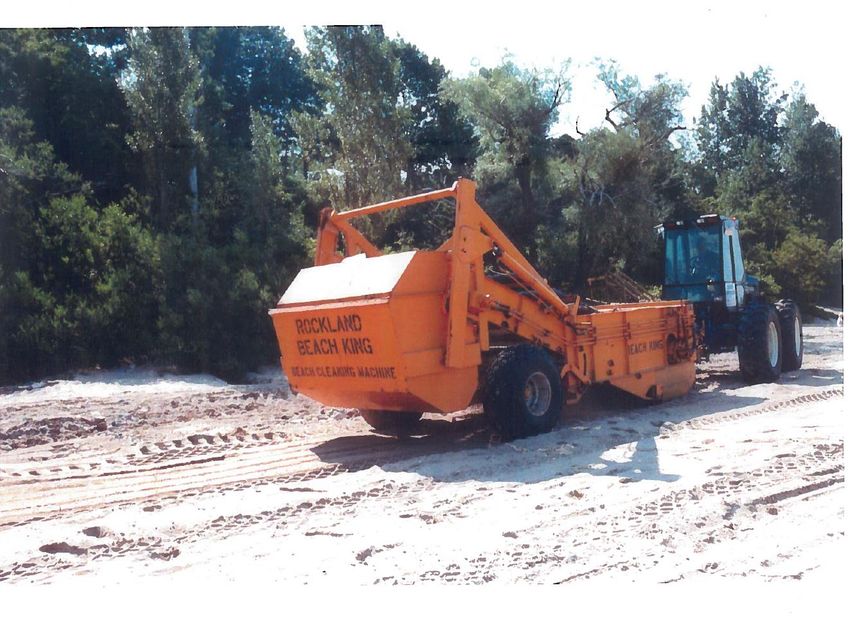
Funding for this project was provided by the Municipality of Bluewater with in-kind support from the
Steering Committee.

Contributing Authors and Steering Committee members are:

Kelly Vader – Pioneer Park Association

Arlene Parker – Municipality of Bluewater

Hope Brock and Mari Veliz – Ausable Bayfield Conservation Authority

Erica Clark – Huron County Health Unit

Lake Huron Centre for Coastal Conservation 74 Hamilton Street, Goderich, Ontario, Canada N7A 1P9
Ph: (519) 523-4478 Email: coastalcentre@lakehuron.on.ca Website: www.lakehuron.ca

2|Page
Executive Summary
The Lake Huron Centre for Coastal Conservation (herein referred to as the “Coastal Centre”) was
retained by the Bluewater Beach Committee (herein referred to as the “Committee”) to assist in
preparing a Beach Management Plan for Bayfield’s Pier Beach (also called Bayfield Main Pier Beach). In
recent years, the beach has been referred to as the Main Beach. Historically however, it has been the
known as the Pier Beach. The Committee, which consists of representatives from the Pioneer Park
Association, the Municipality of Bluewater, the Huron County Health Unit and the Ausable Bayfield
Conservation Authority (ABCA), has decided to use the historical name for the purpose of this report.

Pier Beach is an important reach or section of the Lake Huron shoreline due to the ease of public access,
which attracts many visitors. Local residents have always recognized its significance and in 1945, Lucy
Woods Diehl, a life-long resident of Bayfield, enlisted the aid of several friends in the community to
purchase and preserve the last piece of undeveloped lakefront property on the bluff overlooking the
Bayfield River and Lake Huron. This property named Pioneer Park contains a portion of the 140-metre
length of Pier Beach. Three entities own (and actively manage) the beach: the Pioneer Park Association,
the Municipality of Bluewater, and the Crown.

Considering the dynamic nature of the shoreline, the many potential users, and the multiple owners of
the Pier Beach, it is important that this area be co-managed with an acknowledgment of the sensitivity
of this limited resource. Beach users grow accustomed to the presence of certain amenities, and in
keeping with the limitations of this area, may have to forego some user wants to continue to benefit
from the health and enjoyment that this beach currently offers the residents of Bayfield and beyond.

The goal of this report is to provide recommendations for the on-going management of this important
Lake Huron beach. The report provides an explanation of Bayfield’s coastal setting and the coastal
processes that formed the beach and continues to shape its future. From this background information,
key recommendations are provided that have been vetted by the community and are intended to guide
future management decisions. Further information regarding these recommendations can be found in
Section D (p. 24) and E (p. 35).

i)    Public Input and Engagement

The Bayfield Pier Beach is a prime location serving both local residents and tourists alike. The ultimate
management of this site should be made with consideration of both the needs of Pioneer Park
Association and the Municipality of Bluewater, as well as the residents of Jowett Lane. It is
recommended that the plan be re-visited after five years.

ii)   Beach Sand Management

The municipality in conjunction with Pioneer Park Association may wish to consider a pilot project using
sand fencing to capture blowing sand. Erecting two parallel rows of sand fencing along the beach in the
offseason (i.e., November to March) parallel to the shoreline, could add to the reservoir of sand on the
beach. This project would only be suitable if the lake water levels were at average or low levels.

Use of harbour dredging and sand disposal from the Bayfield River is a practice of beach nourishment
commonly found along American ocean and Great Lake coastlines which supplies new sand from offsite
3|Page
to augment the beach sand resources. Due to potential contamination issues related to dredged
material, this approach is not recommended for the Pier Beach. Furthermore, sand nourishment from
other outside sources is also not recommended.

iii)   Beach Grooming

Mechanical beach grooming on Bayfield’s Pier Beach is not recommended, and if required, used
sparingly and only when specific thresholds are exceeded (e.g., algae is covering the first three metres of
shore, a die off of fish or shore birds has occurred).

iv)    Invasive Plant Management

Beach zones and riparian corridors need to be protected from the expansion of Phragmites australis.
Contaminated equipment will make this plant much more mobile and more of a threat to the Bayfield
River, Bayfield beaches and natural areas. If mechanical equipment needs to cross the beach area to
access the lakeshore for maintenance purposes, the equipment should be pre-cleaned to safeguard
against cross-contamination from other impacted sites.

v)     Beach Entrance/Gateway

Due to the potential obstruction of views, fluctuating water levels, and on-going maintenance issues, it
is recommended that the entrance to the beach, and the beach itself, be left in its current state with no
plantings (e.g., trees or dune grass) of any type.

Newly placed armour stone around the parking area will act as a physical barrier to prevent vehicles
from entering the beach while also providing maintenance-free seating areas for visitors.

vi)    Lighting

Pioneer Park Association, the Municipality of Bluewater and the community have indicated a clear
commitment to protecting the natural environment. To date, there is not a clear need for lighting at the
beach.

vii)   Signage

Signage should be consolidated as much as possible into one attractive structure. A double or triple in-
line sign system to incorporate 4 to 6 panels for mounting is recommended. Signage should include an
acknowledgement of partial ownership by the Pioneer Park Association. Pioneer Park and the
Municipality of Bluewater will provide input into wording and placement of signage.

4|Page
viii) Accessibility

There are many options for what would make the beach more accessible (e.g., boardwalk, benches,
picnic tables), however, given the limited size of the beach and the maintenance required for such
items, no structures are recommended to be placed on the beach, even if they are designed to be
mobile.

In order to make the pier area more accessible, it is recommended that there be an accessible parking
space as close to the entranceway as possible. A summer maintenance program for the hard-surfaced
area would help to reduce sand accumulation.

Size and font of letters on non-glare signage and high-colour contrast between the sign and the letters
are important considerations.

ix)   Waste Management

A regularly scheduled ‘shoreline cleanup’ should be continued, or if not already an annual event,
arranged to assist in waste management. In addition, careful attention not to disturb the ‘strand line’
should be part of the education and awareness program prior to instructing volunteers to perform the
cleanup. Strand lines provide important nutrients to a sterile environment.

All waste receptacles should be accessible and the Butt-Free beach program should continue to provide
education regarding proper disposal of cigarette butts.

x)    Water Quality

Recommendations for water quality issues are separated into actions and monitoring components.

Actions
a. All pet waste needs to picked up and properly disposed in appropriate receptacles.
b. Investigate the need for public education on the importance of pet waste pick up and disposal, and
    whether sufficient disposal receptacles exist within the Village of Bayfield including the harbour.
c. Ensure there are no cross connections or leaks between sanitary sewers or old septic systems and
    stormwater drainage facilities.
d. As part of the stormwater master plan for the village of Bayfield, gain a better understanding of the
    watershed drained by 1) the Tuyll outfall, and 2) the ephemeral channel that emerges on the bank
    near Colina Street.
e. Continue to engage the local community with information about stormwater management and low
    impact development technologies (e.g., rain barrels, rain gardens, permeable pavement) through
    outreach activities of the Main Bayfield Watershed Plan.
f. Continue to support community actions such as demonstration rain gardens.
g. Assist the Municipality of Bluewater in implementing low impact development technologies (e.g.,
    permeable pavement, grass swales, rain gardens) for existing infrastructure and proposed
    developments.

Monitoring
h. Continue to monitor water quality, specifically Escherichia coli (E.coli) at the public beach with the
   assistance of the Huron County Health Unit.
5|Page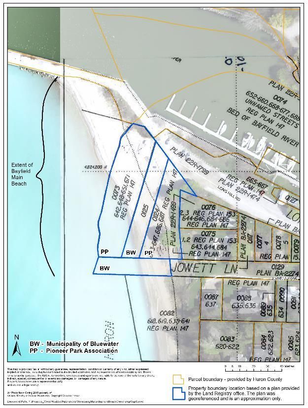
i.     Continue to monitor water quality (E.coli, total phosphorus and soluble reactive phosphorus) at the
       Colina, Tuyll and Delevan stormwater outfall sites.

xi)      Surface Water Drainage and Bluff Vegetation

Surface water drainage and bluff vegetation are two important factors that are often overlooked when
considering beach management. New drainage channels should not be created when existing drainage
outlets exist nearby (e.g., Bayfield River). This is especially true for inland bluff areas where flowing
water can exacerbate erosion challenges that already exist (i.e., in bluff areas, inland from the crest of
bluffs). Surface water should be managed as close to the source as possible. Natural areas and rain
gardens help to capture water, slow it down and prevent erosion, while also filtering out pollution. Bluff
vegetation is important in providing slope stability as a result of extensive root systems, and should not
be removed. Trees, shrubs and plants also help to filter out pollutants before they reach the lake.

xii)     Beach Safety

Signage regarding wave refraction and reflection off the steel sheet pile lining the jetty and rip currents
offshore require adequate warning signs for beach users and swimmers. The Lifesaving Society
recommends that ‘No Swimming’ signage be installed on the pier and on the beach to the south of the
pier (at least 50 metres south of the pier). These are the recommendations from the Lifesaving Society,
however, due to the current arrangement of the defined swimming area, ‘no swimming’ signage would
not be suitable at these locations. Signage warning of deep water and currents could be erected on the
pier should the Municipality of Bluewater choose to do so.

In order to keep swimmers separated from watercraft operators, the swimming area should be clearly
marked as per the recommendations in the aquatic safety audit (Lifesaving Society, 2018). Depth of the
swimming buoys should reflect current best practice.

xiii) Beach Management Programs and Options (including Pier Beach)

In order to benefit the health and safety of the Bayfield Pier Beach, the promotion of these programs
should be continued.

     Program Name                     Delivery Organization
     Butt-Free Beach                  Lake Huron Coastal Centre
     Beach Clean-Up Events            Blue Bayfield, Lake Huron Coastal Centre, Pioneer Park Association
     Blue Flag Beach                  Municipality of Bluewater (Environmental Defence)
     Coast Watchers                   Lake Huron Coastal Centre
     Living Beaches                   Lake Huron Coastal Centre
     Main Bayfield Watershed Plan     Ausable Bayfield Conservation Authority
     Rip Current Awareness            Royal Canadian Lifesaving Society in conjunction with Lake Huron
                                      Coastal Centre
     Watershed Report Card            Ausable Bayfield Conservation Authority
     Water Quality Monitoring         Ausable Bayfield Conservation Authority, Huron County Health Unit

6|Page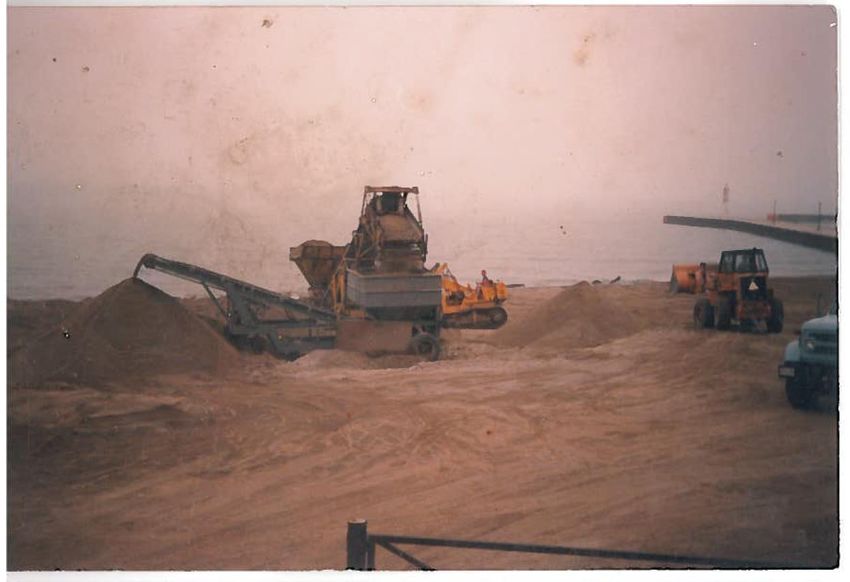
Bayfield Pier Beach Management Plan

A.             Introduction .................................................................................................................................. 9
B.             Bayfield’s Coastal Setting ........................................................................................................... 12
     i)        Bayfield Harbour Structure ........................................................................................................ 12
     ii)       Sand Movement ......................................................................................................................... 13
     iii)      Sand Origin ................................................................................................................................. 13
     iv)       Water Levels ............................................................................................................................... 14
      v)       Beach Stability ............................................................................................................................ 15
     vi)       Dynamic Beach ........................................................................................................................... 16
C.             Human History…at the beach ..................................................................................................... 19
     Case #1 – Huron Terrace ........................................................................................................................ 19
     Case #2 – Delevan Point ......................................................................................................................... 20
     i)        Historic Beach Grooming............................................................................................................ 23
     ii)       Shoreline Protection ................................................................................................................... 23
D.             Community Interests and Issues and Recommended Actions for Beach Management .......... 24
      xiv)     Public Input and Engagement .................................................................................................... 24
      xv)      Beach Sand Management .......................................................................................................... 25
      xvi)     Beach Grooming.......................................................................................................................... 25
      xvii) Invasive Plant Management ...................................................................................................... 26
      xviii) Beach Entrance/Gateway ........................................................................................................... 27
      xix)     Lighting........................................................................................................................................ 28
      xx)      Signage ........................................................................................................................................ 28
      xxi)     Accessibility ................................................................................................................................. 29
      xxii) Waste Management ................................................................................................................... 30
      xxiii) Water Quality.............................................................................................................................. 30
      xxiv) Surface Water Drainage and Bluff Vegetation .......................................................................... 32
      xxv) Beach Safety................................................................................................................................ 33
      xxvi) Beach Management Programs and Options (including Pier Beach) ......................................... 33
      xxvii) Beach Management Examples from other Great Lakes Harbour Sites..................................... 34
      xxviii) Other Considerations .................................................................................................................. 34
E.             Summary ..................................................................................................................................... 35
F.             References / Literature Cited: .................................................................................................... 37
7|Page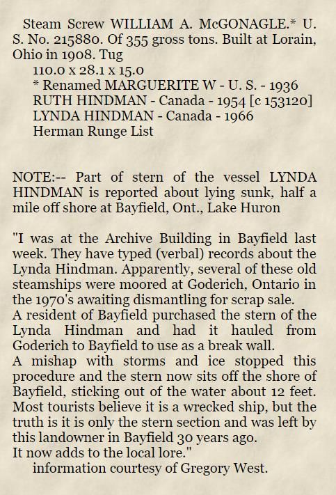
List of Figures
   Figure 1: Location of Pier Beach ........................................................................................................ 10
   Figure 2: Ownership and extent of Pier Beach .................................................................................. 11
   Figure 3: Bayfield Breeze masthead showing brown, sediment-laden water is flowing from the
      outlet of the Bayfield River mouth. ............................................................................................... 14
   Figure 4: Lake Huron historic water level charts over the last 100 years (top) and the last 20 years
      (bottom) (Canadian Hydrographic Service and Fisheries and Oceans Canada, 2016). ................. 15
   Figure 5: Pier Beach showing harbour piers (top), precast concrete cylinders and armour stone
      shore protection (bottom). ............................................................................................................ 16
   Figure 6: Shoreline land survey from 1935 showing water’s edge and high water mark (HWM)..... 18
   Figure 7: Historic Pier Beach postcards and photos from 1919, 1925 and 1940 showing the
      Delevan Point which no long exists (photo credit: Bayfield Historical Society). ........................... 20
   Figure 8: Aerial photo in 1931 of Bayfield showing Delevan Point (arrow), an area of land between
      1 Tuyll Street and Delevan Street, which no longer exists. Lake level = 176.8 metres IGLD (photo
      credit: Bayfield Historical Society). ................................................................................................ 21
   Figure 9: Bayfield shoreline in 1951 showing Delevan Point (lake level 176.0 metres IGLD) (top)
      and 2017 (lake level = 176.8 metres IGLD) (bottom) showing Delevan Point no longer present. 22

 List of Tables

   Table 1: Education and outreach programs delivered in the Pier Beach area by local agencies. .... 34
   Table 2: Summary of community interests and issues and recommendations actions for beach
     management. ................................................................................................................................. 35

 Appendices

   Appendix 1: Historical References ..................................................................................................... 39
   Appendix 2: A Brief History of Beach Grooming in Bayfield .............................................................. 42
   Appendix 3: Beach Cleaning Policy .................................................................................................... 47
   Appendix 4: ACTion Best Management Practices ............................................................................. 50
   Appendix 5: Fillet Beaches and Harbour Structures .......................................................................... 52

8|Page
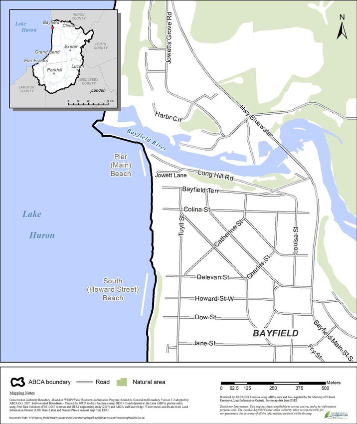
A. Introduction
The Lake Huron Centre for Coastal Conservation (herein referred to as the “Coastal Centre”) was
retained by the Bluewater Beach Committee (herein referred to as the “Committee”) to assist in
preparing a Beach Management Plan for Bayfield’s Pier Beach (also called Bayfield Main Pier Beach). In
recent years, the beach has been referred to as the Main Beach. Historically however, it has been the
known as the Pier Beach. The Committee, which consists of representatives from the Pioneer Park
Association, the Municipality of Bluewater, the Huron County Health Unit and the Ausable Bayfield
Conservation Authority (ABCA), has decided to use the historical name for the purpose of this report.

Pier Beach is an important reach or section of the Lake Huron shoreline due to the ease of public access,
which attracts many visitors. Local residents have always recognized its significance and in 1945, Lucy
Woods Diehl, a life-long resident of Bayfield, enlisted the aid of several friends in the community to
purchase and preserve the last piece of undeveloped lakefront property on the bluff overlooking the
Bayfield River and Lake Huron. This property named Pioneer Park contains a portion of the 140-metre
length of Pier Beach. Three entities own (and actively manage) the beach: the Pioneer Park Association,
the Municipality of Bluewater, and the Crown.

Considering the dynamic nature of the shoreline, the many potential users, and the multiple owners of
the Pier Beach, it is important that this area be co-managed with an acknowledgment of the sensitivity
of this limited resource. Beach users grow accustomed to the presence of certain amenities, and in
keeping with the limitations of this area, may have to forego some user wants to continue to benefit
from the health and enjoyment that this beach currently offers the residents of Bayfield and beyond.

The goal of this report to provide recommendations for the on-going management of this important
Lake Huron beach. The report provides an explanation of Bayfield’s coastal setting and the coastal
processes that formed the beach and continues to shape its future. From this background information,
key recommendations are provided that have been vetted by the community and are intended to guide
future management decisions.

Pier Beach is a relatively short section of shoreline approximately 140 metres in length extending south
from the harbour to Jowett Lane (see Figure 1). Ownership of the beach rests with the Pioneer Park
Association (Parcels 073 & 0124), the Municipality of Bluewater (Parcels 0125 & 029) and the Crown
(see Figure 2), however, the Bayfield Pier Beach Management Plan is a management plan between the
Municipality of Bluewater and the Pioneer Park Association. The beach lies immediately west of the
Longhill Road, Jowett Lane and a small enclave of seven houses. The beach is classified as a Blue Flag
Beach according to criteria evaluated by Environmental Defence.1 Although a management plan is not a
requirement for Blue Flag designation, the Committee felt that a plan would enhance environmental
protection and promote collaborative, considered beach management.

The Bayfield Pier Beach is narrow and isolated from the surrounding landscape given the location
between the south harbour pier and large armour-stone bluff protection that bisects the bluff to the

1
 A Blue Flag is awarded to beaches that meet strict criteria in the areas of water quality, environmental
management, environmental education, and safety and services. In Canada, the program is delivered by
Environmental Defence, an environmental organization.
9|Page
south. Inland, the beach merges with the cottage lots, which are bordered by the river valley
wall/lakeshore bluff.

Figure 1: Location of Pier Beach

10 | P a g e
Figure 2: Ownership and extent of Pier Beach
11 | P a g e
The beach is a mixture of relic sand deposits from the lake and cobbles washed by the Bayfield River at a
time before the harbour structures existed. Together these materials form the beach that is exposed
during average and low Lake Huron water levels, and significantly submerged during high water levels.
The beach location next to, and downdrift of, the harbour structure, has limited the build-up of sand
deposits and makes the beach reliant on specific environmental conditions. As further discussed in this
report, it is only during lower water levels and southwest wind and wave conditions, that the beach
replenishes itself with sand. The beach is therefore fragile, sand-starved and requires careful
management.

The purpose of this report is to provide the Committee a Beach Management Plan that provides a basic
coastal process understanding and the background justification that informs the management
recommendations for Pier Beach. The approved Plan should be reviewed and updated within five years
from adoption. The Pioneer Park Association will renew their commitment to the plan each year at their
Annual General Meeting.

     B. Bayfield’s Coastal Setting
The historic community of Bayfield founded in 1832, has approximately three kilometres of Lake Huron
shoreline that consists of a narrow beach that varies in width with the fluctuating Lake Huron water
levels. Tall, glacial-till bluffs approximately 15 to 20 metres in height back this shoreline. Tourist
publications for Bayfield advertise two sandy, public beaches for tourists to enjoy – Pier (Main) Beach,
and South (Howard Street) Beach.

Pier Beach (140 metres long) is the subject of this report and is unusual in Bayfield in that it is the only
public beach (with a portion that is privately owned by Pioneer Park) that is not entirely bordered
landward (to the east) by a tall bluff. Rather a low, river-cut terrace extends landward beside the outlet
of the Bayfield River where a cluster of seven cottages exists. This terrace further described below, is
adjacent to the Pier Beach. It is described as the only public beach in Bayfield without a set of stairs
needed to access it.

Riverbank erosion and deposition developed a terrace, which now separates the river from the beach.
Historically before the harbour jetties were constructed, the river would have flowed across this terrace,
moving sand and other river-transported material back and forth depending on such factors as the river
conditions, lake conditions and wind directions. The harbour jetty structures have played, and continue
to play, an important role in how this beach area reacts and adjusts to changing weather and lake
conditions.

i)    Bayfield Harbour Structure
After construction of the harbour structure, termed jetties, in the late 1880’s, sand being washed along
the shoreline (called ‘littoral drift’) collects on the updrift, or north side of the jetties making the beach
wider north of the harbour jetties (i.e., adjacent to Deer Park Lodge and Jowett’s Grove) than the beach
south of the jetties (i.e., Bayfield Pier Beach). A ‘fillet beach’ is the name used to describe these wider
beaches updrift of harbour structures that can also be found updrift of the harbours in Grand Bend and
Goderich in addition to many other harbours where they interfere with littoral drift. Beach widths on
average from Bayfield to Goderich were estimated in 1988 as being 14 metres in width and generally
between 1.5 and 3.0 metres above water levels (Ministry of Natural Resources, 1988). Beach width

12 | P a g e
conditions in 2017 appear similar to this historic average with the Pier Beach being approximately 20
metres in width (Google Maps, 2017) with the lake water level at 176.8 metres IGLD.2
Northwest is the predominant wind direction along this coastline and north-south is the coast
orientation stretching from Point Clark in the north (near the community of Amberley) to Grand Bend in
the south. Therefore, Pier Beach lies in what has been described as the ‘shadow zone’ of the harbour
jetty structure because of three factors: 1) the prevailing northwest winds, 2) the north-south beach
orientation, and 3) the length of the harbour jetties.
A rough estimate of the size of the shadow zone is generally regarded as extending along the shore
three times the overall length of the harbour jetties. In Bayfield, that calculation creates a zone that is
approximately one kilometre south from the Bayfield River ending in the general vicinity of Dow Street
along the shoreline. It is believed that sand bypassing the harbour jetties does occur given that the filet
beach has reached maximum capacity for sand storage. Therefore, the shoreline south of Dow Street
will benefit by the supply of this bypassed sand along that shoreline. Conversely, the shoreline north of
Dow Street to the harbour jetty, including the Pier Beach, is in a deficit sand supply environment.
ii) Sand Movement
Although there are many types of beaches on Lake Huron (e.g., cobble beaches, lag beaches), sand
beaches are the most treasured beaches from a recreational standpoint. Fine sand particles are the
most sought after as they are the easiest to navigate with bare feet for swimmers and beach goers. This
small-sized sand material also makes it easily moved by both wind and waves. Mechanisms of sand
movement are described as ‘aeolian’ (wind-borne sand) or ‘littoral drift’ (water and wave moved sand).
These two mechanisms of sand movement on Pier Beach are directly related to lake water levels.
During low water levels, wind will increase sand movement on the beach creating small dunes and
collecting sand at the base of the terrace. However, a full dune profile (i.e., embryo dunes, foredunes
and back dunes) is not feasible at this location. During high water levels and/or severe storms, waves are
the primary mechanism of sand movement shaping and sculpting the shore. Storm waves are the prime
force to erode the sand from the beach by moving up the beach, and at some high water levels, colliding
with the base or ‘toe’ of the bluff.
iii) Sand Origin
Beach sediments, including sand material, are generated from three sources: river and gully outlets,
bluff erosion, and the movement onshore of lake-bottom deposits. Pier Beach is likely a combination of
all three sources given the close proximity to bluffs that have eroded over the past decades (see
description in Beach History – Case #1), the proximity of the Bayfield River that frequently deposits
material offshore from the jetty outlet after storm events (see Figure 3), and wave action that brings
offshore sediments onto the shore. In recent years, wave action and onshore winds that deposit sand
during lower water levels are the most likely origin of beach sand currently existing on the Pier Beach.
2
International Great Lakes Datum (IGLD) is an elevation reference system used to define water levels.
13 | P a g eFigure 3: Bayfield Breeze masthead showing brown, sediment-laden water is flowing from the outlet of the Bayfield River mouth. The sediment budget (which takes into account sand sources, transportation and deposition zones) between Goderich Harbour and Kettle Point has been estimated between 10,000 to 30,000 cubic metres per year of littoral material moving along the shoreline. The material comes from all three sources: bluff erosion, gullies and rivers, and offshore lake bottom sediments. This reach of coastline, which includes Bayfield Pier Beach, has been identified as Littoral Cell H-2 (Ministry of Natural Resources, 1988). The Bayfield community shoreline is further refined as Subcell 3 in the ABCA Shoreline Management Plan which extends from the harbour south to Maple Grove subdivision (Baird and Ausable Bayfield Conservation Authority, 2019). Sediments moved by wind and water do not move outside this cell; they are entirely contained between these two coastal features. A small portion of the beach at the west end of Jowett Lane contains beach grass and other native plant species that appear relatively healthy. They should be safeguarded from damage and may benefit from sand fencing to promote sand deposition. iv) Water Levels Lake Huron water levels have historically ranged approximately two metres vertically over the 100-year period of record from 1918. This range has included the highest recorded level in 1986 of 177.8 metres IGLD to the lowest recorded level in 2012 of 175.6 metres IGLD. An average water level is generally regarded to be 176.6 metres IGLD (see Figure 4). Present water levels recorded in December 2017 are 176.8 metres IGLD. Therefore, current water levels on Lake Huron are in the mid-range of the historic record; they could fluctuate one metre either way before they reach the recorded extreme levels. 14 | P a g e
Figure 4: Lake Huron historic water level charts over the last 100 years (top) and the last 20
years (bottom) (Canadian Hydrographic Service and Fisheries and Oceans Canada, 2016).

v)    Beach Stability
Beaches provide the best natural protection against wave attack and erosion as they provide an erosion
buffer to benefit inshore development (e.g., buildings, infrastructure). In addition, they also provide
habitat for rare coastal plants (e.g., American Beach Grass) and animals. However, it is noted that within
this short section of Pier Beach, no rare or unique species have been found or documented (Huron
County, 2015).
The location of the Pier Beach to the south, or in the lee of the harbour jetties, makes it sheltered from
the most common storm waves generated from northwest winds. In addition, the ongoing actions of the
Pioneer Park Association to stabilize the adjacent bluff (see Figure 5) have made the beach relatively
stable. Along this high-energy shoreline, only westerly or southwesterly winds will generate waves that
directly impact Pier Beach.

15 | P a g e
(photo credit: The Coastal Centre - June 2010 water level = 176.6 m IGLD)

                                        (photo credit: ABCA – May 2017 water level = 176.8 m IGLD)
Figure 5: Pier Beach showing harbour piers (top), precast concrete cylinders and armour stone
shore protection (bottom).
Storms creating waves from these directions and fluctuating water levels will most often be the cause of
changing conditions to the beach in width and sand supply. Therefore, changing water levels must be
considered in the long term for beach management plans and are included in Section D. Community
Interests and Issues and Recommended Actions for Beach Management.

vi)   Dynamic Beach
The dynamic nature of a shoreline is best illustrated by beaches, which are typically the most changing
ecosystem of Lake Huron. The general description of a dynamic beach (the constant movement and
fluctuation of the beach) is contrasted with a technical description of a dynamic beach as defined by
provincial hazard policy:

16 | P a g e
In Ontario, a Dynamic Beach is any beach greater than 0.3 metres in depth of beach material,
AND is greater than 10 metres in width, AND is greater than 100 metres in length, AND has
greater than 5 kilometres in offshore fetch (also known as open water) in combination with at
least 60 degrees of lake exposure measured on either side of a line perpendicular to the beach.
(Ministry of Natural Resources, 1988)
The ABCA Shoreline Management Plan has identified only the fillet beach north of the harbour as
Bayfield’s dynamic beach using the technical description, since the Pier Beach characteristics are too
limited (Baird and Ausable Bayfield Conservation Authority, 2019). The supply of beach material,
directions of available wave activity and significant submergence by water during high water levels limits
the dynamic nature of this beach south of the harbour piers.
Under high water conditions (e.g., in 1935 and 1986), the beach would be narrow or submerged
underwater. To illustrate the point, a land survey of the shoreline completed in 1935 (see Figure 6)
shows the High Water Mark (HWM) at the base of the bluff. Therefore, at times, the beach was
nonexistent. However, the actual water level shown on the survey as of July 30, 1935 suggests a beach
width that is 86 metres wide (shown on the plan as 4.3 chains). This suggests a very flat beach with a low
beach elevation near the water level of 176.05 metres IGLD on that date.
More recently, record high water levels and storm waves in 1986 moved across the beach and
threatened the stability of the Pioneer Park bluff and the terrace area near the Jowett Lane
neighbourhood. This high water period was the impetus for the installation of a number of hardened
protection structures (i.e., concrete rubble, mobile wave busters, pre-cast concrete cylinders). Reactive
measures such as these are seldom completed with the forethought of proper design and future
maintenance. Further evidence of this is the sinking of a steamship hull in 1977 offshore from the
Metcalf House at #1 Tuyll Street by Brigadier General Dr. Morgan Smith. Historic accounts (see Appendix
1) suggest this was done “….to act as a breakwater to stop further erosion on the cliff that house sat
atop” (Jerome, 2014).
Any beach is considered a ‘hazard’ only due to the instability of the beach material when considering the
installation of poorly-sited permanent structures, construction of buildings or other forms of human
development. Regulations managed by Ontario’s Conservation Authorities and land use policies
17 | P a g eFigure 6: Shoreline land survey from 1935 showing water’s edge and high water mark (HWM). 18 | P a g e
managed by municipalities via their planning process recognize this hazardous nature and promote
hazard avoidance. The shifting sands of a dynamic beach will eventually undermine building
foundations, destabilize erosion protection walls and expose sensitive infrastructure (such as septic field
beds).
Assessing beach stability from a regulatory perspective is devised using a rating system that incorporates
a three digit, one to three rating system (Ministry of Natural Resources, 1988). A 3:3:3 beach rating (e.g.,
Ipperwash Beach) is the most dynamic while a 1:1:1 beach rating (e.g., Providence Bay, Manitoulin
Island) being the least dynamic. The rating numbers reflect three beach characteristics, being Fetch
Length: Beach Width: Sand Size. Pier Beach would be rated as a ‘less dynamic beach’ given its location in
the shadow of the jetties and in a deficit sand supply environment.
Using the terminology of a ‘sediment budget’, the Pier Beach is in a reach of shoreline that is considered
a sediment ‘transport’ zone, as opposed to a sediment ‘source’ zone (e.g., Bluewater Beach, Central
Huron) or sediment ‘sink’ zone (e.g., Ipperwash Beach, Lambton Shores). Beaches in ‘source’ zones are
narrow (or nonexistent) whereas beaches in ‘sink’ zones are wide with plentiful sand resources. Beach
widths in sediment ‘transport’ zones, as in Bayfield’s Pier Beach, are variable depending on water levels.
Beach management goals for Pier Beach should recognize the physical nature of the beach and
establish proper expectations. Pier Beach will never become a beach with physical characteristics
resembling Miami Beach (Florida), Cavendish Beach (PEI) or Ipperwash Beach (ON) as examples.
Expectation management is an important factor to consider.
C. Human History…at the beach
The Bayfield River and the adjacent community is rich in human history. Glimpses of that history can be
seen in the historic photographs and records of the beach and its users stored within the Bayfield
Archives (bayfieldhistorical.ca). Shoreline features (beach and bluffs) in the background of these
photographs, illustrate considerable historic change. These changes are important considerations in
long-term beach management as they demonstrate the evolving conditions of the shoreline. New
residents or visitors will not have a long history or knowledge of the shoreline needed to understand
the dynamic nature.
Case #1 – Huron Terrace
Huron Terrace (also called Terrace Lane) was a designated municipal road right-of-way that historically
paralleled the top of the bluff from Bayfield Terrace to Christy Street. Bluff erosion made the road
unsafe and the road was officially closed by the municipality and offered for sale to adjacent landowners
in 1989 (Ausable Bayfield Conservation Authority, 2000). Bluff erosion continues to be a concern to
adjacent landowners and erosion activity is directly related to water levels. Bluff erosion contributes
sand material to area beaches, however in communities such as Bayfield where permanent residences
are located close to the bluffs; wise bluff and beach management are needed to ensure unintended
consequences of individual actions do not occur. Proper surface water drainage and maintaining
healthy, native vegetation are two important factors often overlooked on bluffs and beaches creating
dire consequences.
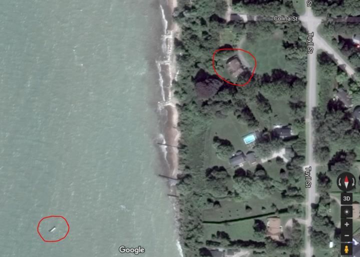
19 | P a g eCase #2 – Delevan Point
A substantial point of land appears along the shoreline in maps, vacation photos and aerial photographs
prior to 1950, which has since disappeared. A point of land appears in the background of vacation
photos taken from beach level in the 1919, 1925 and 1940 (see Figure 7). Further analysis reveals that
this point of land existed in 1931 at the south side of the Metcalf Property at 1 Tuyll Street (see Figure
8). This point is likely what can be seen in the vacation photos. It also appears in the 1951 oblique air
photo (see Figure 9) and is located approximately at the west end of Delevan Street. This point is within
the harbour jetty shadow zone. No definitive explanation has been provided for the disappearance
other than possibly the extension of the harbour jetty lakeward in 1969 and continued shoreline erosion
in this sand deficit area.
The discussion of bluff stability is relevant to beach management as it impacts sediment sources,
drainage issues as well as lake water quality. The shadow zone along Bayfield’s shoreline contains
buildings that are beyond the stable slope line and within a moderately eroding bluff area (Baird and
Ausable Bayfield Conservation Authority, 2019). Wise management of these bluff areas considering
more extreme and more frequent storm events and less winter ice cover projected with a changing
climate, will prevent negative impacts to the beach.
1919 (lake level = 176.8 m IGLD) 1925 (lake level = 176.2 m IGLD
1940 (lake level = 176.2 m IGLD
Figure 7: Historic Pier Beach postcards and photos from 1919, 1925 and 1940 showing the
Delevan Point which no long exists (photo credit: Bayfield Historical Society).
20 | P a g eFigure 8: Aerial photo in 1931 of Bayfield showing Delevan Point (arrow), an area of land between 1 Tuyll Street and Delevan Street, which no longer exists. Lake level = 176.8 metres IGLD (photo credit: Bayfield Historical Society). 21 | P a g e
(photo credit: Bayfield Historical Society)
(photo credit: London Free Press)
Figure 9: Bayfield shoreline in 1951 showing Delevan Point (lake level 176.0 metres IGLD)
(top) and 2017 (lake level = 176.8 metres IGLD) (bottom) showing Delevan Point no longer
present.
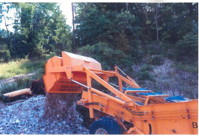
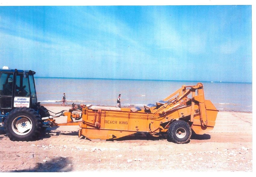
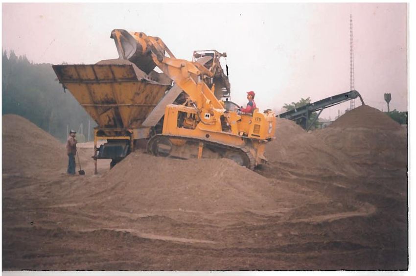
22 | P a g ei) Historic Beach Grooming In a June 2016 report (Heard, 2016) prepared for the Bluewater Beach Committee and presented at the Pioneer Park Annual General Meeting, Don Heard of G. Heard Construction explained how their company has played a role in grooming the Bayfield Pier Beach since the mid-1990’s (see Appendix 2). It was reported that “…two methods were used; an industrial approach using heavy equipment with a commercial screening plant, and smaller, tractor-pulled beach grooming equipment. The smaller equipment was a Rockland Beach King model that with each pass of the equipment would pick-up sand to a depth of 6 inches, screen it, and deposit the sand back onto the beach. The non-sand debris was collected in a hopper which was then unloaded into a truck for disposal”. No beach grooming activity has occurred since 2000. This report distinguishes between beach ‘cleaning’ and beach ‘grooming’. ‘Cleaning’ is done with hand tools and is focused on picking up litter and garbage; ‘grooming’ is done with mechanical equipment and is less discriminant in what it disturbs. ii) Shoreline Protection Lake Huron water levels reached the highest on record in September 1986 (Canadian Hydrographic Service and Fisheries and Oceans, 2016). In the absence of a management plan to provide guidance, shore protection was hurriedly installed all along the overall shoreline. This ranged from well-designed and coastal-engineered projects to do-it-yourself weekend-style projects. Along the shoreline during this time, it was common to see the dumping of concrete slabs (some with exposed rebar) and the placing of concrete blocks and triangular structures (e.g., Wave Busters and/or Lenson Mobile Breakwaters TM). In addition, the installation of steel, sheet pile walls, breakwaters and groynes extending into the water was popular. Activity was rapid and without the benefit of effective planning. Bayfield Pier Beach has also been ‘protected’ by a variety of structural features. The shoreline adjacent to Jowett Lane has concrete rubble and armour stone along the lake edge of the properties. The northern end of the beach intersects with the harbour jetty, which has large armour stone beside the steel wall acting as protection from wave attack. Wave refraction and reflection occurs off the steel sheet pile wall lining the jetty. This unpredictable wave climate and possible offshore rip currents are further factors that require consideration for wise beach management. In the late 1980’s/early 1990’s the base of Pioneer Park bluff was lined first with concrete triangular pods, which allowed wave action to disperse through slots in the concrete. They were subsequently replaced with the round, pre-cast concrete structures/pipes that exist today (see Figure 5). No report was found in researching this topic suggesting that any detailed investigation went into the design or installation of these features. This report has earlier recounted the sinking of the hull of a steamship offshore of 1 Tuyll Street. Under high water levels, in the fall of 2018, the weathered hull broke up and slipped beneath the surface. 23 | P a g e
D. Community Interests and Issues and Recommended Actions for Beach
          Management
The wise management of beaches is a broad responsibility requiring active participation by many. Roles
exist for the landowner, the municipality, the community and tourists. There are also regulatory roles
that may come into play depending on the scope of the management. Municipal By-laws and
Conservation Authority Regulations are introduced and enforced with the intention of protecting the
beach resource for both human and natural heritage life forms (flora/fauna). This includes all the
citizens and visitors to Bayfield in addition to the aquatic and terrestrial species that also rely on the
beach environment. The Bayfield shoreline is an ecotourism mecca with birding and fishing
opportunities, trails, sailing, swimming and boating. Environmental regulations and municipal by-laws
exist to safeguard these characteristics and opportunities.

When developing management strategies for beach environments, it is also imperative to understand
that these are dynamic ecosystems and that beach conditions will change. The past weather conditions
will not be the same as the future given our changing climate. Water level fluctuations within a similar
range of two metres will likely continue into the future. However, the frequency and ferocity of severe
storms are likely to increase. This adds relevance to the notion of ensuring shore protection is in good
condition and that sparse sand reserves on the beach are wisely protected. More periods of sparse
winter ice cover on the lake will likely create more storm-wave shore erosion given a reduced amount of
shore-fast ice. A recent discussion paper for the updated Ausable Bayfield Conservation Shoreline
Management Plan suggests that mean sediment transport along beaches may increase by up to 50
percent (Davidson-Arnott, 2016). This could translate into less sand and gravel being retained on
beaches where erosional forces exist thus reducing beach widths. Understanding past shoreline
changes will help in predicting and managing future shoreline changes in order to ensure wise long-
term beach management.

The following recommendations are derived from an analysis of the identified issues listed in the project
Terms of Reference, past beach management plans from other areas, and from the discussion on the
coastal processes explained in the previous sections.

xiv)    Public Input and Engagement

Community Interests and Issues

The unique co-ownership of the Bayfield Pier Beach requires that all parties be involved in the process of
cohesively managing the beach.

Recommended Actions

The Bayfield Pier Beach is a prime location serving both local residents and tourists alike. The ultimate
management of this site should be made with consideration of both the needs of Pioneer Park
Association and the Municipality of Bluewater, as well as the residents of Jowett Lane. These residents
have much to gain from wise beach management and will provide the Committee a watchful eye
observing how the beach is utilized. Multiple goals for the beach were identified in previous public

24 | P a g e
meetings and they should be reviewed to ensure their inclusion (Grodzinski, 2014). It is recommended that the plan be re-visited after five years. xv) Beach Sand Management Community Interests and Issues Dune development will be a severe challenge and unlikely on Bayfield Pier Beach due to the sand deficit and limited dune-building conditions. Recommended Actions The municipality in conjunction with Pioneer Park Association may wish to consider a pilot project using sand fencing to capture blowing sand. Erecting two parallel rows of sand fencing along the beach in the offseason (i.e., November to March) parallel to the shoreline, could add to the reservoir of sand on the beach. This project would only be suitable if the lake water levels were at average or low levels. Therefore, the project would not be implemented if levels rose to above 177.0 metres IGLD. Sand fencing instructions are provided on the resource page of the Coastal Centre website (lakehuron.ca). Three years would provide a reasonable sample to see if the specific wind directions needed (southwesterly and westerly) are frequent enough during the offseason to make this approach worthwhile. Fencing near the small patch of dune vegetation on the beach at the west end of Jowett Lane may increase sand supplies with multiple benefits. Use of harbour dredging and sand disposal from the Bayfield River is a practice of beach nourishment commonly found along American ocean and Great Lake coastlines which supplies new sand from offsite to augment the beach sand resources. Due to potential contamination issues related to dredged material, this approach is not recommended for the Pier Beach. Furthermore, sand nourishment from other outside sources is also not recommended. xvi) Beach Grooming Community Interests and Issues The Bayfield Pier Beach sand is a limited resource, bordering on being a relic sand source given the location in the harbour shadow zone, with minimal opportunity for replenishment. New sand deposition will only occur during low water levels and with a very specific wind environment (southwest or west winds) to promote aeolian transport. Therefore, the available beach sand is limited, the balance is fragile and requires careful management. Recommended Actions Mechanical beach grooming on Bayfield’s Pier Beach is not recommended, and if required, used sparingly and only when specific thresholds are exceeded (e.g., algae is covering the first three metres of shore, a die off of fish or shore birds has occurred). 25 | P a g e
The weight of machinery and tire treads compacts the beach sand and kills fragile plants and animals
that inhabit the beach. Beach cleaning using hand tools/volunteer labour should be used to remove
human-caused garbage as they can target the specific beach location where this is needed. ‘Shoreline
cleanup’ is a term commonly used to address garbage and litter found on the beach and easily removed
by volunteers and regular beach patrols. Care is needed not to mistake the ‘strand line’ composed of
twigs, plant matter and what would normally be called detritus, as garbage needing removal. This is the
food source for many animals and without it, would create a sterile beach.
Mechanical beach grooming has historically occurred at this beach without any recorded issues or
negative impacts. However, conditions in 2018 have changed (e.g., extreme weather events,
introduction of invasive plant species, increased environmental awareness) to make the practice more
prone to negative or unintended consequences. Ease of access by equipment from the parking lot is
likely the most obvious reason this activity has historically been used for aesthetic beach improvement,
an access situation unique for Bayfield’s public beaches. However, it can be argued that the practice
provides little or no environmental benefit.
Beach grooming is an activity with several potential disadvantages and therefore this approach it is not
recommended by the Coastal Centre (as stated in the position paper on Mechanical Beach Grooming –
Lake Huron Coastal Centre, 2011). The reasons include:
the removal of the ‘strandline’ (or ‘wrack line’) being an important nutrient source for shoreline
species of both plants (e.g., sea rocket) and animals (e.g., gulls);
the sifting of sand can lead to increased sand transport by wind by aerating the top layer which
transports the sand inland (e.g. into Jowett Lane or into the harbour) and possibly outside the
active beach zone;
increasing the opportunity for invasive plants to establish since equipment cleaning prior to use
on the beach is not commonly nor easily done, nor commonly enforced;
a deterrent to proper litter and garbage control / wise waste management if the grooming is
intended for litter control (e.g. removing micro plastics, cigarette butts).
Note: an exception to this practice is if equipment is needed to remove large
masses of algae that has washed up on the beach, or for other potential human
health hazards (e.g., dead birds, fish kills).
A draft beach cleaning policy is included in Appendix 3 to provide additional guidance for municipal
staff and private beach clean-up efforts.
xvii) Invasive Plant Management
Community Interests and Issues
Phragmites australis (or Common Reed), a non-native, invasive reed has become widespread
throughout southern Ontario. It has been added to the list of Canada’s Worst Weed. Phragmites can
out-compete other plant species and develop into a dense monoculture stand up five metres in height
and up to 200 stems per square metre. Once it gains a foothold, it can spread along shorelines a
26 | P a g edistance of three metres per year. Impacts on shorelines, especially coastal wetlands, include changes to hydrology, nutrient cycling and lost habitat for wildlife. Phragmites is not just a problem for ecology; it is also impacting local economies, particularly shoreline communities. It affects property values and reduces recreational opportunities. Phragmites control is a priority for the Lake Huron shoreline due to the negative impact this plant is having on the ecology and the ability of the landowners and beach visitors to see and enjoy the lake. In a report by the Coastal Centre (Alexander, 2012), several sites with Phragmites were identified along the shoreline in Bayfield (e.g., end of Cameron and end of Colina Street) as well as to the south at Wildwood Beach and Blue Bluff Road. These relative small sites need attention to ensure the spread of this plant does not occur. The Bayfield River is another transportation route for the spread of this invasive species. Sightings have been made along the river and reported by Conservation Authority staff and community members. Recommended Actions The threat and intended control program is similar to the attention given to preventing the transportation of zebra mussels by cleaning boat hulls. Beach zones and riparian corridors need to be protected from the expansion of this invasive plant species. Contaminated equipment will make this plant much more mobile and more of a threat to the Bayfield River, Bayfield beaches and natural areas. If mechanical equipment needs to cross the beach area to access the lakeshore for maintenance purposes, the equipment should be pre-cleaned to safeguard against cross-contamination from other impacted sites. Pier Beach should continue to be monitored for any growth of Phragmites and controlled according to provincial best management practices. Information on the control of this invasive plant can be found on the Coastal Centre website (lakehuron.ca) and on the Ontario Phragmites Working Group website (opwg.ca). xviii) Beach Entrance/Gateway Community Interests and Issues The visual appearance of the beach is important for several reasons: a) to create a visually appealing and harmonious appearance for visitors and residents using the beach, and b) to ensure that sight lines are not disrupted or cluttered. Currently the Bayfield Pier Beach entrance has no landscaping plan to address aesthetics. Recommended Actions Due to the potential obstruction of views, fluctuating water levels, and on-going maintenance issues, it is recommended that the entrance to the beach, and the beach itself, be left in its current state with no plantings (e.g., trees or dune grass) of any type. In addition, the site conditions with sand, cobbles and river deposits will be too permeable to hold water and therefore not conducive to plant growth. 27 | P a g e
You can also read