Karst piracy: A mechanism for integrating the Colorado River across the Kaibab uplift, Grand Canyon, Arizona, USA
←
→
Page content transcription
If your browser does not render page correctly, please read the page content below

CRevolution 2: Origin and Evolution of the
             Colorado River System II themed issue

                              Karst piracy: A mechanism for integrating the Colorado River
                                 across the Kaibab uplift, Grand Canyon, Arizona, USA

             Carol A. Hill1,* and Victor J. Polyak1
             1
              Earth and Planetary Sciences, University of New Mexico, 221 Yale Boulevard, Albuquerque, New Mexico 87131, USA

             ABSTRACT                                                         INTRODUCTION                                                  Babenroth and Strahler (1945) were the
                                                                                                                                         first to try and explain how the river may have
                Age, isotopic, and detrital zircon data on                    Past Work                                                  crossed the Kaibab uplift: it had coursed around
             the Hualapai Limestone Member and Muddy                                                                                     the south-plunging nose of the Kaibab upwarp,
             Creek Formation (western United States)                             How did the Colorado River cross the Kaibab             with scarp retreat being downdip to the south
             constrain the time of the first arrival of the                   uplift? Why does the river run nearly south for            in soft Moenkopi and Chinle shales. Strahler
             Colorado River on the west side of the Grand                     hundreds of miles, then for no obvious reason              (1948, p. 536) elaborated on the weakness of
             Canyon to ca. 6–5 Ma. We propose a karst                         turn abruptly southwest to west in the Desert              this model: “…some reason must be shown why
             piracy mechanism, along with a 17–6 Ma                           View area of Grand Canyon (Blackwelder, 1934;              the river commenced to cut vertically down-
             western paleo–Grand Canyon, as an alterna-                       Fig. 1)? These are questions that have perplexed           ward into Paleozoic strata instead of continuing
             tive explanation for how the Colorado River                      geologists since John Wesley Powell’s first river          to shift south, downdip, as the Mesozoic beds
             became integrated across the Kaibab uplift                       trip in 1869.                                              were progressively stripped away.” Strahler’s
             and for the progressive upsection decrease
             in δ18O and 87Sr/ 86Sr values of the Hualapai
             Limestone Member. An earlier Laramide
             paleocanyon, along which this western paleo-
             canyon followed, can also perhaps explain
             why no clastic delta exists in the Grand Wash
             trough.
                Karst piracy is a type of stream piracy
             where a subterranean drainage connection
             is made under a topographic divide. The
             process of karst piracy proceeds through
             five main stages: (1) establishment of a gra-
             dient across a topographic divide due to
             headward erosion into the low side of the
             divide, (2) leakage in soluble rock along the
             steepest gradient, (3) expansion of the leak-
             age route into a cave passage that is able to
             carry a significant volume of water under the
             divide, (4) stoping and collapse of rock above
             the underground river, eventually forming a
             narrow gorge, and (5) widening of the gorge
             into a canyon. A karst piracy model is pro-
             posed here for the Kaibab uplift area that
             takes into account the structure and hydrol-
             ogy of that area. Other examples of karst
             piracy operating around the world support
             our proposition for integrating the Colorado
             River across the Kaibab uplift in the Grand                      Figure 1. Location map showing pertinent geographic features and those mentioned in the
             Canyon.                                                          text. LF—Lees Ferry, DV—Desert View, CoR—Colorado River. The Hualapai, Las Vegas,
                                                                              and Lake Mojave basins are from Spencer et al. (2008). The Hualapai Limestone Member
                                                                              and the Bouse Formation in Figure 8 were deposited in the Lake Hualapai basin and Lake
                 *Email: carolannhill@aol.com                                 Mojave basin, respectively, shown in this figure. Cross-section A–B is also in Figure 4.

             Geosphere; August 2014; v. 10; no. 4; p. 627–640; doi:10.1130/GES00940.1; 8 figures; 1 table.
             Received 22 April 2013 ♦ Revision received 7 May 2014 ♦ Accepted 5 June 2014 ♦ Published online 24 June 2014

                                                                                For permission to copy, contact editing@geosociety.org
                                                                                                                                                                                     627
                                                                                        © 2014 Geological Society of America

Downloaded from https://pubs.geoscienceworld.org/gsa/geosphere/article-pdf/10/4/627/3332495/627.pdf
by guest
Hill and Polyak

       (1948) objection is especially true in the case of              upwarp.” Hunt’s concern was echoed by Spencer           side of a topographic divide with the other side,
       the very resistant Kaibab Limestone, which has                  and Pearthree (2001), who argued against this           whereas karst piracy refers to the mechanism by
       formed the caprock of the Grand Canyon area                     mechanism based on characteristic rates of head-        which this connection is achieved.
       for many millions of years. According to Dick-                  ward erosion in arid climates, and by Pelletier            Longwell (1928, 1946) concluded, from his
       inson (2013), when encountering nonresistant                    (2010), who calculated that a pre–6 Ma basin            geologic and fossil observations of the Muddy
       rock, extensive lowlands are developed across                   west of the Kaibab uplift, such as proposed by          Creek Formation in the Grand Wash trough
       fold crests, but when they encounter resistant                  Young (2008), would only have been able to              (Fig. 1), that no Colorado River gravels had
       strata they migrate laterally down the plunge                   headward erode as far as the mid-Grand Canyon           reached the west side of the Grand Canyon
       of the fold until forced to incise downward into                and never reach the Kaibab uplift.                      until after the deposition of the Hualapai Lime-
       harder rock. In this case, what factors would                      Wernicke (2011) proposed a further mecha-            stone Member. This young (late Miocene to
       have forced incision into the very resistant Kai-               nism that invoked a California River that incised       Pleistocene) age for a Grand Canyon carved
       bab Limestone, and in what time frame would a                   much of the Grand Canyon to near its present            by the Colorado River became referred to as
       Mesozoic scarp still have been present to facili-               depth in the latest Cretaceous, including the inci-     the Muddy Creek problem, because it was
       tate the forcing?                                               sion of the Kaibab uplift section. However, the         deduced that Longwell’s (1928, 1946) observa-
          Lucchitta (1975, 1984, 1989), in a variation                 geological and thermochronological data of Karl-        tions disallowed a canyon older than this. New
       of the Babenroth and Strahler (1945) model,                     strom et al. (2014) for integration of the 6–5 Ma       data have further constrained when and how the
       invoked a Miocene Colorado River crossing the                   Colorado River through a more recent (25–5 Ma)          Colorado River first traversed the canyon, so
       nose of the Kaibab uplift along an arcuate strike               route across the Kaibab uplift, in addition to the      now the problem is sometimes referred to as the
       valley carved in Mesozoic rock and continuing                   traditional so-called Muddy Creek constraint on         Muddy Creek constraint (Lucchitta, 2011). In
       northwestward on the west side of the uplift and                the first arrival of Colorado River sediment to         this paper, by “Muddy Creek,” we specifically
       into the ancestral Virgin River drainage basin.                 the Grand Wash trough at 6–5 Ma (Lucchitta,             mean Muddy Creek Formation deposits within
       A number of problems exist with this model.                     2011), seriously challenges Wernicke’s early (ca.       the Grand Wash trough area. These rocks were
       Where is the evidence for Colorado River-type                   70 Ma) time frame for crossing the uplift.              originally assigned to the Muddy Creek Forma-
       gravels along the west side of the Kaibab uplift                   We propose integrating the Colorado River            tion in Virgin Valley (Stock, 1921), but later
       or anywhere on the plateaus north of the Grand                  under the Kaibab uplift via karst piracy. Karst         renamed “rocks of the Grand Wash trough” by
       Canyon? To where did Lucchitta’s (1975, 1984,                   piracy is a subtype of stream piracy where              Bohannon (1984) because they were somewhat
       1989) supposed Miocene-age ancestral Colo-                      streams are pirated under a topographic divide          older than, and deposited in a separate basin
       rado River flow? Not into the Muddy Creek                       along a soluble rock horizon such as limestone.         from, the defined Muddy Creek.
       Formation in the Great Basin (Pederson, 2008).                  On a small scale, karst piracy can be thought              Names that refer to canyons existing prior to
       Furthermore, according to the thermochrono-                     of as a diversion; for example, the diversion of        the present-day Grand Canyon of the Colorado
       logic unroofing model of Lee et al. (2013, fig.                 water from an upper-level cave to a lower-level         River have changed significantly since they
       9D therein), by the early Miocene (18 Ma) there                 cave with a different outlet. However, here we          were first proposed, thus causing confusion in
       was no Mesozoic rock in the immediate area                      use the term to describe karst processes that           terminology among researchers. We use the
       of the future Grand Canyon across the Kaibab                    rearrange surface drainage on a grand scale.            terms paleocanyon, paleo–Grand Canyon, and
       uplift (river miles ~80–90).                                       All of these Kaibab uplift-crossing models           paleo–Little Colorado River (or paleo–Colo-
          Blackwelder (1934) originally suggested a                    remain speculative, including the karst piracy          rado or San Juan rivers) when referring to geo-
       lake spillover hypothesis for the upper Colo-                   model we propose, because it is very difficult          morphologic features that existed prior to the
       rado River corridor (Fig. 1), where the Colorado                to confirm a model where the route may now be           modern Grand Canyon system. However, when
       River had overflowed a number of lake basins                    obscured or eroded away.                                quoting earlier papers we use the old names (and
       by breaching topographic barriers. Black-                                                                               new names) to establish historicity. We also use
       welder’s (1934) regional idea of lake overflow                  Terminology                                             the term Kaibab uplift instead of Kaibab arch or
       was revived by Meek and Douglass (2001) and                                                                             upwarp, except when quoting a historic article.
       Scarborough (2001) and specifically applied                        Two terms in the literature have been con-
       to the carving of the Grand Canyon. Meek and                    fused with karst piracy. Hunt (1974) used the           Motivation and Purpose
       Douglass (2001) proposed that a large lake had                  term “piping” to describe subterranean water
       spilled westward across the Kaibab uplift ca.                   diverted into the Grand Wash from the Huala-               This paper proposes that karst piracy was
       6 Ma, thus initiating rapid incision of the can-                pai Plateau. However, in karst terminology, pip-        the connection mechanism of integrating the
       yon. The many arguments against this model                      ing refers to the settling of soil or loose debris      Colorado River across the Kaibab uplift in
       were summed up by Dickinson (2011, 2013),                       into an underground void, not to cave passages          the Grand Canyon. A karst connection model
       who concluded from various lines of evidence                    that take water from one area to another (Ford          for the Grand Canyon was first proposed in Hill
       that lake spillover is not a viable model.                      and Williams, 1989; Palmer, 2007a). Ground-             et al. (2006, 2008); the concept of karst piracy
          Hunt (1956) proposed yet another mechanism                   water sapping was the term used by Pederson             was introduced in Hill et al. (2012). However,
       for crossing the Kaibab uplift, i.e., stream piracy,            (2001) to describe a mechanism for breaching            this paper is not just a review or update of those
       where headward erosion cuts into, and finally                   a topographic divide, but this term appears to          earlier papers, but an attempt to explain how the
       across, a topographic divide. However, even                     be synonymous with stream piracy and is not             process of karst piracy might have worked in a
       Hunt (1956, p. 85) was suspicious of this mecha-                the mechanism of karst piracy described in this         real-world case, the Grand Canyon, something
       nism’s validity: “It would indeed have been a                   paper. The term karst connection, used in Hill          that has not been done, even in publications
       unique and precocious gully that cut headward                   et al. (2008), is not quite the same as karst piracy;   such as Journal of Caves and Karst or in the two
       more than 100 miles across the Grand Canyon                     karst connection refers to the condition of sub-        most influential karst books, Karst Hydrogeol-
       section to capture streams east of the Kaibab                   terranean water hydrologically connecting one           ogy and Geomorphology (Ford and Williams,

       628                                                                           Geosphere, August 2014

Downloaded from https://pubs.geoscienceworld.org/gsa/geosphere/article-pdf/10/4/627/3332495/627.pdf
by guest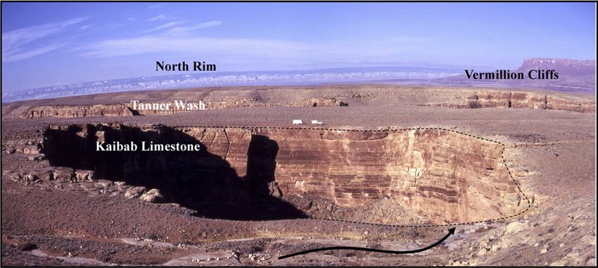
Karst piracy, Grand Canyon

             2007) and Cave Geology (Palmer, 2007a). Thus
             our paper breaks new ground in that it describes
             a mechanism for the development of landforms
             like the Grand Canyon that have not previously
             been considered as having been caused by, or
             related to, karst.
                The importance of karst piracy to this Geo-
             sphere themed volume is that it not only offers
             an alternative way for the Colorado River to have
             crossed the Kaibab uplift, but it also offers an
             explanation for the age and isotopic data of the
             Hualapai Limestone Member and Muddy Creek
             and Bouse Formations west and southwest of
             the Grand Canyon. It also relates to a major con-
             troversy among Grand Canyon researchers, i.e.,
             whether a westward-flowing Colorado River first
             transected the Grand Canyon area ca. 6 Ma, the
             consensus of geologists in the past, or was the
             canyon incised down to almost its present depth
             ca. 80–70 Ma by an eastward-flowing river, as
             according to the thermochronologic models
             of Flowers et al. (2008), Wernicke (2011), and
             Flowers and Farley (2012). The karst piracy
             model supports a 6–5 Ma age for the integration
             of the Colorado River from Colorado, through
             a Grand Canyon along the same route as today,
             and then to the Gulf of California. The main pur-
             pose of this paper is to propose a new concep-
             tual mechanism for the geomorphic evolution
             of the Grand Canyon that addresses a number
             of important questions that still remain from the
             past two decades of Grand Canyon research.

             REGIONAL PERSPECTIVE

             Geologic Model with Respect to
             Karst Piracy
                                                                              Figure 2. A schematic diagram over a Landsat image showing the geomorphology of the
                On the basis of geomorphic evidence such as                   eastern Grand Canyon ca. 6–5 Ma as proposed in Hill et al. (2008) and Hill and Ranney
             barbed tributaries along Marble Canyon (Ranney,                  (2008). The paleo–Little Colorado River was flowing north up Marble Canyon to the inte-
             1998), a young and narrow Marble Canyon                          rior Glen Lake, with the barbed tributaries of Marble Canyon being interpreted as evi-
             located only 2.8 km from the Chuar basin, and                    dence of this once, north-flowing paleo–Little Colorado River. The paleo–Colorado River
             the affinity between fossil fish in the Snake River              was flowing south into Glen Lake, and the paleo–San Juan River was flowing west into Glen
             and latest Miocene (upper) part of the Bida-                     Lake. The very narrow Marble Canyon was interpreted in Hill et al. (2008) to be a young
             hochi Formation (Spencer et al., 2008), it was                   river channel caused by headward erosion from the confluence of the Colorado and Little
             proposed in Hill et al. (2008), Hill and Ranney                  Colorado rivers up to Glen Lake after Little Colorado River water became completely
             (2008), and Hill et al. (2011) that a paleo–Little               captured by the confluence sinkholes. The white dashed arrow denotes the flow of the paleo–
             Colorado River had flowed north from a series of                 Little Colorado River before a karst connection; the blue solid arrow denotes the flow of
             ephemeral lakes (collectively called Hopi Lake;                  the Colorado River after a karst connection. The route of the proposed karst connection is
             Dallegge et al., 2003) into an interior lake (the                outlined by a red dashed line. The parallel yellow lines are N50E joints, which correspond
             proposed Glen Lake of Hill et al., 2006) in south-               to joint trends in the southern part of the Marble Plateau (Sutphin and Wenrich, 1988)
             ern Utah at least by 16 Ma until ca. 6 Ma (Fig. 2).              and can be seen on the Landsat image. The final connection with Glen Lake ca. 6–5.5 Ma
             The paleo–Little Colorado River was diverted ca.                 allowed the Colorado and San Juan rivers to flow south through Marble Canyon, down
             6 Ma into a series of sinkholes in the area where                the sinkholes at the confluence of the Colorado and Little Colorado rivers, and under the
             the confluence of the Colorado River and Little                  Kaibab uplift, to exit on the west side of the uplift at Hance Spring. The Colorado River then
             Colorado River exists today. This downward                       flowed through Grand Canyon to the Grand Wash trough, and from there south to the Gulf
             diversion of progressively more Little Colo-                     of California. LF—Lees Ferry, HS—Hance Spring, pCoR—paleo–Colorado River, pSJR—
             rado River water into the Confluence sinkhole                    paleo–San Juan River, pLCoR—paleo–Little Colorado River; “paleo” denotes these rivers
             complex could have caused the rapid headward                     before the modern Grand Canyon system was established. After ca. 6 Ma, the Little Colo-
             incision of Little Colorado River Canyon, thus                   rado River flowed into the Colorado River. Ah Hol Sah is the sinkhole shown in Figure 5.

                                                                                            Geosphere, August 2014                                                      629

Downloaded from https://pubs.geoscienceworld.org/gsa/geosphere/article-pdf/10/4/627/3332495/627.pdf
by guest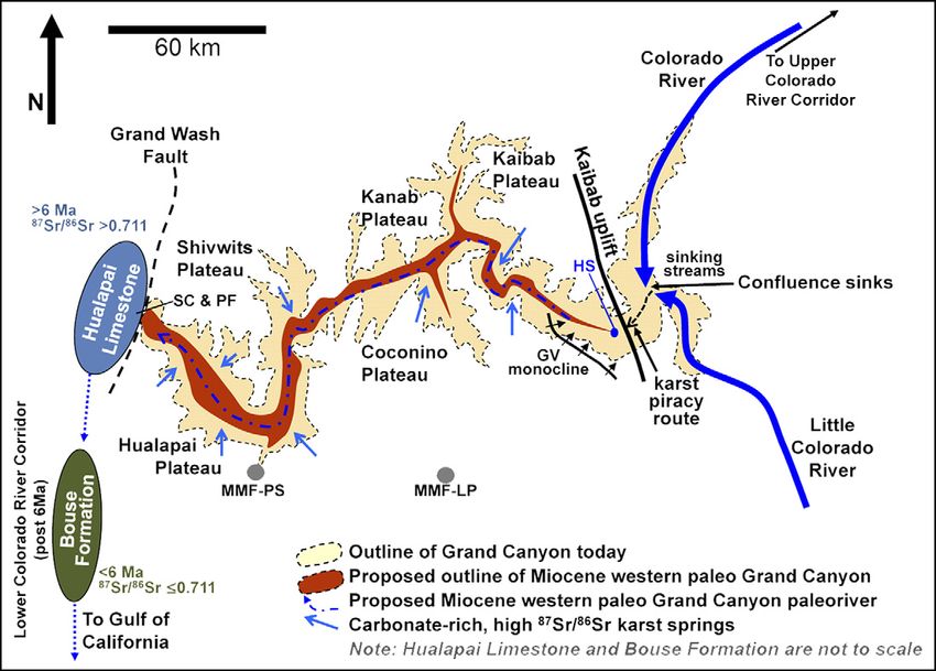
Hill and Polyak

       possibly initiating the ca. 6 Ma fluvial stage of               Thunder River that have waterfalls cascading               In Polyak et al. (2008), the age limits of
       the Bidahochi Formation (Dallegge et al., 2003)                 from their entrances.                                   paleo-water tables within the Grand Canyon
       and possibly terminating the Neogene Crooked                       Caves formed under confined hydrologic               were defined from U-Pb ages on mammillary
       Ridge paleoriver system prior to canyon incision                conditions are those that formerly developed            calcite within caves and in surface exposures;
       at 6–5 Ma (Hereford et al., 2013).                              (or are developing) in the phreatic (saturated)         lower than expected Miocene water tables in
          The model of Hill et al. (2008) and Hill and                 zone below relatively impermeable caprock.              the western Grand Canyon are consistent with
       Ranney (2008) proposes that, once the paleo–                    The majority of the Grand Canyon confined               a pre–Colorado River, Miocene (17–6 Ma)
       Little Colorado became completely siphoned                      caves are found in the Mooney Falls Member              western paleo–Grand Canyon, as well as with
       underground at the confluence of the Colorado                   of the Redwall Limestone, with sandstones of            the similar western canyon proposed by Young
       and Little Colorado rivers, headward ero-                       the Supai Group forming the impermeable cap.            (2008). The water-table data (Polyak et al.,
       sion also proceeded north from the confluence                   The phreatically developed caves in the Grand           2008) support a karst piracy model because a
       along the course of what is now Marble Canyon                   Canyon happen to be hypogenic, although this            karst piracy mechanism would be difficult to
       to make a final connection with Glen Lake ca.                   is not true of most confined caves in the world.        propose without a fluvial system incising into
       6–5 Ma (Fig. 2). Thus, according to this geomor-                Hypogenic means that the source of solutional           the west side of the Kaibab uplift.
       phic model, it was a karst piracy mechanism that                aggressiveness to dissolve caves is from depth
       actually caused Marble Canyon to form where                     rather than from surface infiltration (Palmer,          Isotopic Data
       it did 6–5 Ma, an age for Marble Canyon first                   2007a; Hill and Polyak, 2010).
       proposed in Hill et al. (2008) and later supported                 The mechanism of karst piracy is unre-                  The δ18O values and 87Sr/86Sr ratios reported
       by the thermochronological and geological work                  lated to both of these cave types. Karst piracy         for the Hualapai Limestone Member and Bouse
       of Karlstrom et al. (2014). Once a final connec-                involves the development of large cave passages         carbonates place constraints on the sources of
       tion was made, the paleo–Colorado River, which                  that transport large volumes of water under             water and sediment delivered to the Hualapai
       flowed south into Glen Lake from Colorado                       a topographic divide, and it also involves the          and lower Colorado River corridor basins (Ros-
       (Fig. 2), was free to continue southward along                  connecting of two areas of different elevation          kowski et al., 2010; Lopez Pearce et al., 2011;
       the course of Marble Canyon to the confluence of                and potentiometric surface on each side of the          Spencer et al., 2011; Fig. 1). Combined, the data
       the Colorado and Little Colorado rivers, where                  divide. In the final stages of this process, the for-   support a nonmarine origin for the Hualapai
       it then followed a subterranean route under the                 mer presence of karst piracy caves is difficult to      Limestone Member and for most of the Bouse
       Kaibab uplift. After ca. 5 Ma, collapse of                      document because of their being obliterated by          carbonates.
       the karst piracy route into a narrow canyon and                 headward erosion, stoping, collapse, and canyon            Lopez Pearce et al. (2011) reported a gradual
       its subsequent deepening and widening over the                  deepening and widening along the former karst           upsection decrease of δ18O values in the Huala-
       past few million years created the current Desert               piracy route. Therefore, there may be no direct         pai Limestone Member and attributed this trend
       View section of the Grand Canyon.                               proof that these caves once existed, as is the          to increasing freshwater and higher elevation
                                                                       case for the Kaibab uplift and the Grand Can-           recharge over time; they reported a similar trend
       Types of Caves and Karst Processes                              yon. However, there is indirect evidence on the         for carbon isotopes. Roskowski et al. (2010) and
                                                                       western, Grand Wash trough side of the Grand            Lopez Pearce et al. (2011) reported a gradual
          Before we discuss the process of karst piracy,               Canyon that possibly supports the mechanism             upsection decrease of 87Sr/86Sr ratios in the
       we describe how this type of cave differs from                  of karst piracy.                                        Hualapai Limestone Member, from 0.7195 to
       other types of caves present in the Grand Can-                                                                          0.7137, and from 0.7195 to 0.7120, respectively.
       yon region. All caves are not alike; they form                  APPLICABLE DATA                                         In comparison to these high strontium ratios for
       by different processes and under different sets                                                                         the Hualapai Limestone Member, Spencer et al.
       of conditions. Therefore, this explanatory dis-                 Age Data                                                (2011) reported 87Sr/86Sr ratios for Bouse car-
       cussion of caves is meant to educate readers not                                                                        bonates (0.7102–0.7114) that are only slightly
       familiar with karst so that the different types of                 The age constraint of when the Colorado              higher than normal Colorado River values
       Grand Canyon caves will not be confused with                    River first arrived in the Grand Wash trough            (0.7103–0.7108). In comparison to both of these
       each other.                                                     involves the 40Ar/39Ar dating of volcanic rocks         value sets, Crossey et al. (2006, 2009, 2011)
          There are two main categories of present-                    located within the Hualapai Limestone Mem-              reported 87Sr/86Sr ratios of 0.709987–0.734234
       day caves in the Grand Canyon: those formed                     ber and Bouse Formation. Spencer et al. (2001)          (n = 11) for hypogene spring water and traver-
       under unconfined hydrologic conditions in the                   reported a date of 5.97 ± 0.07 Ma for a tuff near       tines within the Grand Canyon.
       vadose zone and those formed in the phreatic                    the top of the Hualapai Limestone Member, and
       zone mostly under confined hydrologic condi-                    Sarna-Wojcicki et al. (2011) and Spencer et al.         Detrital Zircon Data
       tions (Huntoon, 1970, 2000a, 2000b; Hill and                    (2013) reported a date of 4.9 Ma for a volcanic
       Polyak, 2010). Caves formed under unconfined                    ash bed in the Bouse Formation of Colorado                 Detrital zircon data on the Hualapai Lime-
       hydrologic conditions above the phreatic zone                   River derivation; both dates imply that the first       stone Member and Muddy Creek Formation in
       are simple drains in the vadose (unsaturated)                   arrival of Colorado River water in the lower            the Grand Wash trough have been offered as a
       zone where water recharges on the Kaibab                        Colorado River corridor may have occurred at            constraint on the source of zircon crystals at the
       Plateau and moves gravitationally down along                    that time. However, Dorsey et al. (2007, 2011)          mouth of the canyon; the constraint being that no
       faults or master joints to form free-surface                    favored a date of 5.3 Ma for when the Colorado          detrital zircon from Colorado entered the Grand
       streams. Usually (but not always) they discharge                River first reached the Gulf of California. Thus        Wash trough until the Colorado River arrived ca.
       from the base of the Muav Limestone and above                   it seems likely that the first arrival of the Colo-     6–5 Ma (Lopez Pearce et al., 2011). These three
       the Bright Angel aquiclude. These are the great                 rado River into the Grand Wash trough occurred          Grand Wash trough samples, two collected at
       North Rim caves such as Roaring Springs and                     sometime between ca. 6 and 5 Ma.                        the same site at South Cove and one at Pearce

       630                                                                           Geosphere, August 2014

Downloaded from https://pubs.geoscienceworld.org/gsa/geosphere/article-pdf/10/4/627/3332495/627.pdf
by guest
Karst piracy, Grand Canyon

             Ferry, show a spectra of two peaks ca. 1.4 and                   works (Fig. 3). This model is not meant to be       Stage B
             ca. 1.7 Ga, implying that no detrital zircon input               a specific portrayal of karst piracy under the
             came from the nearby Colorado Plateau; other-                    Kaibab uplift, but roughly illustrates some of         Stage B represents the period of hydraulic
             wise, the samples should also contain Paleozoic                  its geomorphic features: an uplift that water       control of Palmer (2007a), where flow con-
             peaks. Dickinson et al. (2012) reported detrital                 goes under (or through) from east to west           tributed by a surface stream loses only part of
             zircon results on the arkosic gravels of the Late                down the hydraulic gradient, headward ero-          its water to an underlying water-filled conduit.
             Cretaceous to middle Eocene Music Mountain                       sion from the west, a soluble limestone unit        This condition is usually limited to small under-
             Formation (Young, 1999), collected from Long                     overlain by confining beds, and a canyon            ground flow routes that have not yet reached
             Point and Peach Springs Canyon, that have                        that eventually forms from this evolutionary        cave size. If there is enough water to keep the
             very similar Precambrian peaks (ca. 1.45 and                     process. In the next section we present a more      conduit completely filled throughout the year,
             ca. 1.75 Ga), but that also have Jurassic peaks                  realistic model of karst piracy for the Grand       the amount of flow at this stage depends only
             ca. 170 Ma. In addition, Tillquist et al. (2012)                 Canyon based on what is known about the             on the physical characteristics of the conduit
             reported Middle Jurassic (ca. 163–160 Ma)                        structure, stratigraphy, and karst hydrology of     (length, diameter, sinuosity, roughness). In
             ages for rhyolite volcanic clasts from the Music                 the Kaibab uplift area.                             stage B most of the water discharging from the
             Mountain Formation near Long Point. The                                                                              outlet spring is probably provided by autogenic
             Jurassic and Precambrian detrital zircon peaks                   Stage A                                             recharge rather than allogenic recharge, that
             perhaps imply a provenance from the Laramide                                                                         is, from water falling on the karst area (curved
             Mogollon Highlands that formerly bordered the                       Stage A of Figure 3 shows the hydrologic set     arrows, Figs. 3A, 3B, 3C), rather than from the
             southern and southwestern margin of the Colo-                    up before karst piracy begins. In stage A, two      input of river water.
             rado Plateau (Bilodeau, 1986).                                   rivers are shown, one on the east parallel to the      During stage B the conduit opens sufficiently
                                                                              uplift, and a second headward eroding into the      to allow leakage from one side of the uplift to
             KARST PIRACY: A THEORETICAL                                      uplift from the west. Limestone extends com-        the other. Only when undersaturated water is
             MODEL OF HOW IT WORKS                                            pletely under the uplift and is the soluble unit    able to flow all the way through from sink to
                                                                              that will undergo karstification once it begins.    spring is it possible for the conduit to grow.
                In this section we present a theoretical five-                The east recharge side is much higher than the      Secondary permeability along fractures helps
             stage model intended to illustrate the general                   west discharge side, so a steep hydraulic gradi-    solve the problem of water being able to stay
             principles of how the process of karst piracy                    ent is created between them.                        unsaturated, so as to allow the entire flow path

             Figure 3. Five stages of theoreti-
             cal model for a karst connec-
             tion under an uplift via a karst
             piracy mechanism. (A) Before
             karst piracy begins a steep
             hydraulic gradient must be cre-
             ated between the east and west
             sides of the uplift, and a high-
             permeability rock unit must be
             able to transport water under
             the uplift. Headward erosion
             into the uplift proceeds initially
             by the process of stream piracy.
             (B) Leakage occurs under the
             uplift and discharge is at a
             spring or series of springs on
             its west side. The conduit is
             still too small to carry gravels
             under the uplift. At this stage
             spring discharge is mostly from
             autogenic recharge (slightly
             curved arrows) rather than
             from allogenic leakage of river
             water. (C) The river on the east
             side is now completely captured
             and diverted underground.
             The substantial volume and/or
             increase of undersaturated water enlarges the cave passage, so that the river flows freely under the uplift. (D) Unroofing occurs by spring
             sapping, upward stoping, ceiling collapse, and the addition of more undersaturated water through karst windows. This process eventually
             forms a narrow gorge. At this stage, sediment and/or detrital zircon is transported by the river across the uplift. (E) The narrow gorge
             widens and deepens into a canyon. Stages A–D are shown in cross section; stage E is shown in map view.

                                                                                            Geosphere, August 2014                                                             631

Downloaded from https://pubs.geoscienceworld.org/gsa/geosphere/article-pdf/10/4/627/3332495/627.pdf
by guest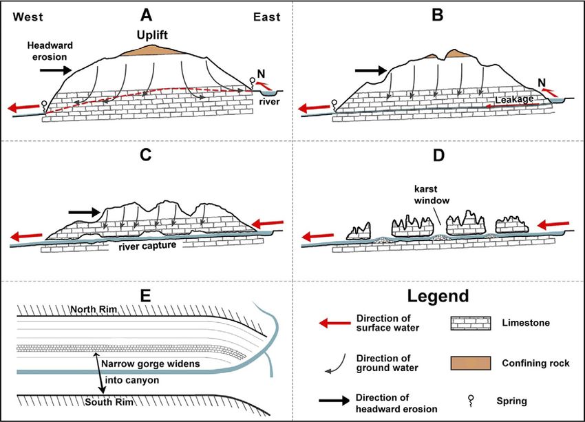
Hill and Polyak

       to dissolve simultaneously. Evolving from leak-                 holes working their way up to the surface           The Redwall Limestone along the Kaibab uplift
       age to a free-flowing stream, the flow path can                 along the trend of the underground channel.         is offset by two splays of the Butte fault. The
       grow somewhat uniformly over its entire length,                 Also, spring sapping (where a spring emerges        proposed discharge spring (Hance Spring) is in
       but nevertheless fastest at the upstream end                    at the head of a valley and the overlying rock      the area of Hance Rapids (now at Precambrian
       where undersaturated river water is recharging                  is quickly undermined by solution and col-          level); just before 6 Ma it would have been at the
       the system.                                                     lapse) is another likely mechanism that facili-     level of the Redwall Limestone. In contrast to
                                                                       tates unroofing. During unroofing, sections of      the theoretical model presented here, recharge
       Stage C                                                         the underground river still flow through the old    on the east is not from a river at the same ele-
                                                                       karst piracy cave passage, while other sections     vation as the Redwall Limestone (as shown in
          As the cave conduit enlarges via undersatu-                  become exposed to the surface. Finally, collapse    Fig. 3), but from a paleo–Little Colorado River
       rated water moving under the uplift, progres-                   is complete along the former underground river      being pirated down a sinkhole complex in the
       sively more flow becomes diverted from the                      and a narrow gorge forms.                           Colorado and Little Colorado rivers confluence
       river until all of its water is captured. Because                                                                   area of the Marble Plateau (Fig. 4).
       this undersaturated river water readily dissolves               Stage E                                                Presented here are the five stages of karst
       more limestone, the karst piracy cave passage                                                                       piracy as applied to crossing under the Kaibab
       becomes larger until a cave stream flows freely                    The final stage of evolution is where the nar-   uplift so as to effect a karst connection. Approx-
       under the uplift. The discharge for this water                  row gorge widens into a canyon, and where con-      imate time spans are given for the last four of
       can be from one large spring on the west side                   tinuing river erosion cuts down into older rock.    these stages; stage A is not given a time designa-
       of the uplift, as shown in Figure 3C, or a series               Figure 3E shows this stage, but with the con-       tion because it encompasses the entire history of
       of smaller springs at slightly different eleva-                 figuration of the Grand Canyon, Marble Can-         the Kaibab uplift (ca. 80–70 Ma) until the time
       tions as headward erosion progressively incises                 yon, Little Colorado River, and Colorado River      when karst piracy began (ca. 8–6 Ma).
       eastward and downward into the west side of                     routes in mind.
       the uplift.                                                                                                         Stage A
                                                                       KARST PIRACY IN GRAND CANYON:
       Stage D                                                         A MODEL OF HOW IT MAY                                  Stage A shows the hydrologic set up before
                                                                       HAVE WORKED                                         karst piracy began (Fig. 4). As in our regional
          Stage D in Figure 3 represents the unroof-                                                                       geomorphic evolution scenario (Fig. 2), we have
       ing phase of stoping, collapse, and headward                       We apply the concept of karst piracy as pre-     the paleo–Little Colorado River heading north
       erosion. Upward stoping by collapse is self-                    sented herein to a geologic cross section across    toward Utah and Glen Lake, and headward ero-
       accelerating because as collapse occurs, the                    the Kaibab uplift (A–B; Fig. 1). Note how the       sion into the Kaibab uplift from the west by the
       partial blockage and diversion of water around                  application of the model, as shown in Figure 4,     17–6 Ma western Grand Canyon of Polyak et al.
       it causes further collapse, the result being large              differs from the theoretical model of Figure 3.     (2008). The difference in elevation between

       Figure 4. A model of how water
       could have crossed under the
       Kaibab uplift from the Marble
       Plateau on the east side of the
       Kaibab uplift to the Hance
       Rapids area on the west side
       of the uplift. The elevation
       difference between the top of
       the Redwall Limestone of the
       two sides is ~356 m and the
       proposed distance between
       recharge and discharge is
       ~22 km, or an overall gradi-
       ent of 0.0166. The sinkhole
       shown at the confluence of the
       Colorado and Little Colorado
       rivers was not a 600-m-deep
       pit; it was a collapse sinkhole
       filled with rubble, as is the case
       today for the large Ah Hol Sah
       sinkhole on the Marble Plateau
       (Fig. 5). The combined thickness of the Redwall-Muav aquifer in the region of the Kaibab uplift is ~180–195 m. BFs—Butte fault splays;
       GVm—Grandview monocline, synclinal axis; HS—Hance Spring; masl—meters above sea level; wt/ps = water table/potentiometric surface
       (water-table data of Polyak et al., 2008). This diagram is based on the geology of Huntoon et al. (1996). The present-day dips of the Redwall
       Limestone along monoclines, and displacements along the two southern branches of the Butte fault, were also considered when making
       this diagram. This diagram roughly follows the northeast-southwest–trending cross-section A–B in Figure 1. Vertical exaggeration = 19.85.

       632                                                                           Geosphere, August 2014

Downloaded from https://pubs.geoscienceworld.org/gsa/geosphere/article-pdf/10/4/627/3332495/627.pdf
by guest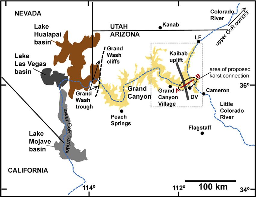
Karst piracy, Grand Canyon

             the two sides of the Kaibab uplift could have                    parallel to the two splays of the Butte fault and      ous Redwall Limestone (Fig. 4), much or most
             been as much as 365 m, thus creating a steep                     up along the eastward-dipping beds of the East         of sinkhole growth would have been upward
             hydraulic gradient between them (Hill et al.,                    Kaibab monocline. The Redwall Limestone in             because of stoping from below, as is the case
             2008; Fig. 4). The Redwall Limestone extends                     these two Butte fault blocks is offset along the       today for the Ah Hol Sah sinkhole on the Marble
             completely under the uplift and is the soluble                   karst piracy route (Fig. 4), and fracture con-         Plateau (Figs. 2 and 5).
             unit that undergoes karstification. The most                     nections between adjacent blocks could have               Sediment carrying detrital zircons probably
             likely transmissive horizon is the Mooney Falls                  allowed water to follow carbonate rock all the         could not have been transported under the Kai-
             Member of the Redwall Limestone because                          way under the uplift. Because the combined             bab uplift during stage B because the connection
             it contains a zone of Mississippian paleokarst                   Redwall-Muav aquifer in the Kaibab uplift area         route was still too tight. In addition, the transi-
             breccia (Hill and Polyak, 2010). This paleokarst                 is ~180–195 m thick, such a carbonate-rock             tion from stages A to B to C took a long time to
             zone of high permeability could have facilitated                 connection seems likely. The vertical exaggera-        develop (probably a few million years; Table 1).
             the movement of water under the uplift because                   tion of Figure 4 makes this proposed path look         Thus, karst piracy under the uplift would not
             a completely low-permeability limestone would                    difficult, but it is not unusual for karst water to    have been abrupt, as would have been the case
             have inhibited the initiation of flow.                           flow through complex structural settings, espe-        for the rapid spillover of a lake.
                Another factor enabling transmission of                       cially up along faults and related fractures when
             water through the Redwall Limestone could                        the hydraulic head difference between two sides        Stage C, ca. 7–6 Ma
             have been fractures and/or joints. Limestone                     of an area is large (Palmer, 2007a).
             may have low primary permeability, but sec-                         The sinkhole shown in Figure 4 at the conflu-          During stage C the paleo–Little Colorado
             ondary permeability can be orders of magnitude                   ence of the Colorado and Little Colorado rivers        River was completely captured and water could
             greater. There are two main fracture trends in                   is also not unrealistic. It has its modern-day ana-    have begun flowing through cave passages
             the Redwall Limestone; both are Mississippian                    log on the Marble Plateau (Ah Hol Sah sinkhole;        under the Kaibab uplift. However, even in this
             in age and formed prior to the deposition of the                 Fig. 5), where recharge is also from the Kaibab        free-flow situation, the pathway was probably
             Supai Group. The first fracture trend strikes, on                Limestone surface down to the Redwall aquifer.         still too convoluted to allow a gravelly bedload
             average, ~N50°–60°E, and the second strikes                      The Colorado and Little Colorado rivers conflu-        to pass, so only water and fine-grained clastics
             ~N40°–50°W (the F1 and F2 joint trends of                        ence sinkhole, like the karst connection route,        could make it all the way under the uplift. Such a
             Roller, 1987, 1989, respectively, measured on                    would have developed slowly, starting with nar-        feat would have had to wait until collapse along
             the Hualapai Plateau). Solutioning is wide-                      row fissures and then enlarging to a maximum           the karst connection route brought the entire
             spread along the F1 trend, and many modern-                      size over many thousands of years. Water proba-        cave stream down toward base level, with a river
             day Grand Canyon caves have developed along                      bly filled the original fissure route (stage B), but   able to carry gravel-size sediment from one side
             this N50°–60°E trend (Hill and Ranney, 2008).                    as the sinkhole enlarged, collapsed, and filled        of the uplift to the other side. Once the karst
             These two joint trends were delineated by Sut-                   with breccia over time, the actual water level         system became fully integrated under the uplift,
             phin and Wenrich (1988) in the Kaibab uplift–                    would have varied depending on the amount of           any stored sediment would have been flushed
             southern Marble Plateau area by an alignment                     recharge and diameter of the hole. Because our         down the system. The transport of gravels under
             of breccia pipe structures. The F1 joint trend in                proposed Colorado and Little Colorado rivers           the Kaibab uplift probably did not occur until
             this area may explain the ~N50°E direction that                  confluence sinkhole bottoms out in the cavern-         very late into stage C and during stage D.
             the Colorado River takes from Basalt Canyon to
             Hance Rapids (Fig. 2); the interpretation is that
             today’s Colorado River may follow the original
             joint-controlled subterranean traverse of karst
             piracy under the Kaibab uplift.

             Stage B, ca. 8–7 Ma

                The Polyak et al. (2008) 17–6 Ma western
             paleo–Grand Canyon reached, and began incis-
             ing into, the west side of the Kaibab uplift ca.
             8–7 Ma, so that water began leaking from its
             eastern side to its western side. Secondary per-
             meability along N50°E fractures in the Redwall
             Limestone could have helped this leakage water
             remain unsaturated so that dissolution could
             proceed relatively uniformly over its length.
             Autogenic water recharging on the Kaibab                         Figure 5. Ah Hol Sah sinkhole on the northern Marble Platueau. The sinkhole is 150 m in
             uplift would have descended to the permeable                     diameter (note vehicles for scale), 40 m deep down to its rubble bottom, and is actively col-
             paleokarst horizon, thus further recharging the                  lapsing into the Redwall karst aquifer hundreds of meters below. A small wash (foreground)
             groundwater system.                                              now drains into the sinkhole (arrow). The water probably discharges from the Redwall
                In a real-world scenario, such as described,                  Limestone along the Fence Spring complex on the east side of the Colorado River. This
             there would have been the complicating effect                    photo shows that sinkholes, such as our proposed 6 Ma Colorado and Little Colorado rivers
             of structure. Small underground flow routes of                   confluence sinkhole, can form on the Marble Plateau and be a mechanism for diverting
             stage B would have developed along fractures                     water down to the Redwall-Muav aquifer. Photo by Bob Buecher.

                                                                                            Geosphere, August 2014                                                                 633

Downloaded from https://pubs.geoscienceworld.org/gsa/geosphere/article-pdf/10/4/627/3332495/627.pdf
by guest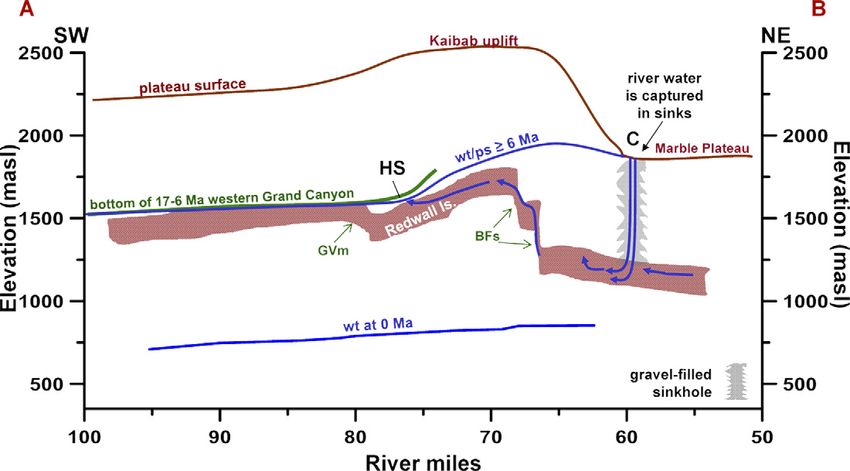
Hill and Polyak

                      TABLE 1. PROPOSED TIMELINE OF EVENTS FROM THE LATE CRETACEOUS TO THE PRESENT AS THEY RELATE TO KARST PIRACY
       Date
       (Ma)             EVENT
       ca. 80–70        The Laramide paleo–Grand Canyon of Hill and Ranney (2008) incised due to the upwarping of the southwestern Colorado Plateau and Kaibab uplift
                          (Kelley and Karlstrom, 2012; Tindall et al., 2010). This canyon had two segments that joined in the Kanab Point area: (1) a deeper western section that
                          formed off the uplifting Hualapai Plateau, and (2) a shallower eastern section that formed off the west side of the Kaibab uplift. The western section
                          incised into the upper Paleozoic clastic units of the Colorado Plateau and this clastic material was transported northward into Utah. This Laramide
                          paleo–Grand Canyon established the route that the later 17–6 Ma western paleo–Grand Canyon and 6–0 Ma Colorado River canyon followed.

       ca. 70–60        A period of aggradation on both the Hualapai and Coconino plateaus; Music Mountain Formation gravels were carried northward to partly fill the Laramide
                          paleocanyons (Young, 1999; Hill and Ranney, 2008; Karlstrom et al., 2014).

       ca. 60–20        Drainage in this Laramide paleocanyon continued to flow northward and transport upper Paleozoic clastics into southern Utah.

       ca. 20–17        The Basin and Range began to downdrop along the Grand Wash fault; probable time of a regional drainage reversal from north to south and then
                          westward to the Grand Wash trough.

       ca. 17–6         (1) The 17–6 Ma western Grand Canyon paleoriver (of Polyak et al., 2008) flowed into the Grand Wash trough due to Basin and Range downfaulting.
                        (2) Headward erosion proceeded up this paleo-western canyon toward, and then into, the Kaibab uplift (stage A of Fig. 3).
                        (3) As this western basin expanded, a progressive increase of freshwater from higher altitudes caused a gradual decrease in oxygen and Sr/Sr isotopic
                            values of the Hualapai Limestone Member.
                        (4) Since this 17–6 Ma western paleoriver follows the route of the Laramide paleo–Grand Canyon, along which a major amount of upper Paleozoic clastic
                            material had already been transported to Utah, detritus from the Colorado Plateau was minimal and there was no clastic delta in the Grand Wash trough.

       ca. 8–7          (1) The 17–6 Ma western paleo–Grand Canyon headward eroded into the west side of the Kaibab uplift and down to Redwall Limestone level. This
                            initiated stage B karst piracy leakage under the uplift.
                        (2) Probably very little sediment/detrital zircon and paleo–Little Colorado River water made it across the Kaibab uplift, but a small amount of leakage water
                            could have contributed to a decrease in Sr/Sr values of the Hualapai Limestone Member.

       ca. 7–6          (1) Once karst piracy stage C was reached and the paleo–Little Colorado was completely captured, headward erosion proceeded northward from the
                            confluence of the Colorado and Little Colorado rivers, up what is now the course of Marble Canyon toward Glen Lake. This erosion caused the
                            formation of a young (6–5 Ma), narrow, Marble Canyon.

       ca. 6–5          (1) Headward erosion reached the Glen Lake of Hill et al. (2006, 2008), and a final connection was made. Once this lake basin was breached, a large
                            volume of Colorado River water flowed south down Marble Canyon, into sinkholes at the confluence of the Colorado and Little Colorado rivers, and
                            then westward under the Kaibab uplift, to arrive in the Grand Wash trough in the time frame of 6–5 Ma.
                        (2) The increase of water volume during stage D facilitated unroofing and collapse along the former karst piracy route.
                        (3) By this time, the Colorado River flowed all the way from Colorado to the Gulf of California and was responsible for the low Sr/Sr Colorado River water
                            values of the Bouse Formation.

       ca. 5–Present (1) The Colorado River was the major eroding agent carving the Grand Canyon; the two older canyons excavated much less material.
                     (2) During stage E, the widening and deepening of the canyon by the Colorado River obliterated the old karst piracy route under the Kaibab uplift.

          A good modern analog for stage C is the                      in the Danube Valley and discharge at Aach              Member of the Muddy Creek Formation in the
       River Danube–Aach spring system of the Swa-                     Spring. The Danube-Aach karst is Holocene in            Grand Wash trough. During this stage, Colorado
       bian Alb, Germany (Fig. 6). The Danube River,                   age (Hötzl, 1996), and therefore dissection, col-       River water was derived from the entire upper
       which flows eastward toward the Black Sea,                      lapse, and headward erosion of this system have         Colorado River and Little Colorado River water-
       is captured in the western Alb by the Danube                    not yet matured (i.e., it is still in the early stage   sheds, and it flowed through the Grand Canyon
       sink (Donauversickerung), periodically leading                  C period and has not yet proceeded to stage D).         carrying Colorado Rocky Mountain detrital zir-
       to a complete loss of water in the upper Dan-                                                                           con to the Grand Wash trough and into the early
       ube (Hötzl, 1996). The disappearing Danube                      Stage D, ca. 6–5 Ma                                     Pliocene Bouse and Imperial Formations south-
       water has been shown by dye-tracer analysis                                                                             west of the Grand Canyon.
       to exit from the Aach spring (Aachtopf); from                      Stage D is the unroofing phase of stoping and           A good modern analog of stage D is the
       there it flows to the River Rhine and North Sea.                collapse. The collapse areas where the surface          Chongquing karst of south China (Fig. 7), where
       The Danube water in its karst transit makes a                   is reached are called karst windows because             cave unroofing (collapse and lateral roof retreat)
       90° turn from east to south and travels 11.7 km                 they allow undersaturated water to enter the            has been shown to be a large-scale geomorphic
       underground from recharge to discharge. In                      underground system (Fig. 3D). Undersaturated            process in the creation of narrow gorges (Klim-
       comparison, the proposed Grand Canyon karst                     Colorado River water and karst-window water             chouk, 2006). In the south China karst, huge
       route would be about twice as long (22 km).                     together would have accelerated the stage D             depressions called tiankengs (karst windows),
       Aach Spring, the largest spring in Germany, is                  unroofing process. Stage D in the Grand Canyon          as deep and wide as 670 m, have collapsed into
       175 m lower in elevation than the Danube sink                   is equivalent to the time when Hill et al.’s (2008)     river cave passages (Palmer, 2007b). The age of
       complex and has an average discharge of 8590                    proposed final connection with Glen Lake was            the Chongquing karst system, which is today
       L/s and a velocity of 195 m/h. Flow time through                made, ca. 5.5 Ma (or after the ca. 6 Ma earliest        only partly unroofed, is late Pliocene to Pleisto-
       this karst system is normally 2 days; such rapid                river constraint) (Fig. 2). It is also the time when    cene (Zhu and Chen, 2005). The distance from
       transit is explainable by flow through cave con-                the Colorado River began flowing through the            sink to spring is 12 km for the Chongquing karst
       duits. The massive carbonate rock sequence,                     entire Grand Canyon, from its west side to its          (compared to 22 km for the proposed Grand
       along which water flows, acts as one hydrauli-                  east side and all the way to the Gulf of Califor-       Canyon karst route), not counting the sinuos-
       cally connected karst aquifer, even though it is                nia. This stage of river transect occurred after        ity of the known cave (A. Palmer, 2013, written
       disrupted by five major faults between recharge                 the final deposition of the Hualapai Limestone          commun.).

       634                                                                           Geosphere, August 2014

Downloaded from https://pubs.geoscienceworld.org/gsa/geosphere/article-pdf/10/4/627/3332495/627.pdf
by guest
Karst piracy, Grand Canyon
performed a numerical modeling study on the
late Cenozoic geomorphic evolution of the can-
yon and concluded that there could have been a
western Grand Canyon prior to Colorado River
integration formed by headward erosion starting
at the Grand Wash fault ca. 16.5 Ma. Pelletier’s
(2010) results are also consistent with speleo-
them records of water-table lowering in the
western Grand Canyon (Hill et al., 2001; Polyak
et al., 2008) and with the Miocene paleogeogra-
phy of the region as interpreted by Young (2008).
We here explain how the concept of a
17–6 Ma western paleo–Grand Canyon fits both
with a karst piracy model and with the isotopic
and detrital zircon data on the Hualapai Lime-
stone Member and Muddy Creek Formation.
Refer to Table 1 for the proposed sequence of
events that relates to this 17–6 Ma canyon and to
how karst piracy fits into this time frame.
A western Grand Canyon headward-eroding
eastward into the Kaibab uplift would be neces-
sary for karst piracy under the Kaibab uplift
because it is essential that there be an elevation
difference between the recharge and discharge
sides of a topographic divide, so that a strong
hydraulic gradient exists between the two sides
(Fig. 3, stage A). Hill et al. (2008) argued that
headward erosion of a western paleo–Grand
Canyon (their protowestern Grand Canyon)
Figure 6. The River Danube–Aach spring system of the Swabian Alb, Germany. Karst
had to incise down to Redwall Limestone level
piracy diverts water in the Danube from flowing to the Black Sea; instead, it finally ends
before the setup could have been right for water
up in the North Sea (after Hötzl, 1996). The proposed distance for the Grand Canyon karst
to discharge on the west side of the Kaibab
system is about twice as long (22 km) as for the Danube-Aach system (11.7 km). However,
uplift; they also suggested that the most logical
the gradient of the Danube-Aach diversion is somewhat less than that proposed for a Grand
place for headward incision to have occurred
Canyon connection route. According to Palmer (1991), the time required to allow rapid dis-
was along the synclinal axis of the Laramide-age
solution along an entire flow path is proportional to gradient (head/length) over length (or
Grandview monocline (Fig. 8), which was filled
i/L in units of cm–1). The i/L for the Danube-Aach system = 1.3 × 10⁻⁸ cm–1, and that proposed
with soft Moenkopi and Chinle Triassic rock.
for the Grand Canyon is ~7.7 × 10⁻⁹ cm–1. Using the i/L charts of Palmer (1991), it would
This idea of a Miocene western paleo–Grand
have required only about twice as long to produce a rapidly forming solution conduit under
Canyon being necessary for karst piracy brings
the Kaibab uplift than at Danube-Aach.
us back to Hunt’s (1956, p. 85) objection to a
Grand Canyon created by a stream piracy mech-
anism: i.e., it does not seem possible that a small
Stage E, ca. 5 Ma–Present ated and superseded by a widening Grand Can- stream would have been able to erode headward
yon. From the age constraints described here, and capture streams east of the Kaibab upwarp.
The final stage of karst piracy evolution is stage D probably happened between ca. 6 and 5 Spencer and Pearthree (2001) argued that head-
where the newly formed narrow gorge widens Ma. Thus, there have been ~5 m.y. during stage ward erosion could not have made it to the
into a canyon, or in the case of the Grand Can- E for the widening and deepening of the Grand Kaibab uplift from the Grand Wash in a Mio-
yon, the section of canyon we see today from Canyon in the Desert View area. cene time frame. In addition, Pelletier’s (2010)
Desert View (Fig. 3, stage E). Today the bottom modeling results (the second of his two models,
of the canyon in this area is far below the level MIOCENE (17–6 Ma) WESTERN based on Young’s [2008] paleocanyon dimen-
of the Redwall Limestone. The caves seen in GRAND CANYON sions) suggest that a western Grand Canyon
the Redwall Limestone high above the canyon eroding headward from the Grand Wash fault
when taking a river trip through the Desert View Based on uranium-lead (U-Pb) dates of water at 16.5 Ma could have only reached a position
bend area are not karst piracy caves, nor are table-type speleothems in Grand Canyon hypo- east of the Shivwits Plateau by 6 Ma. If all of
they related to this process or evidence of this gene caves, a Miocene (17–6 Ma) paleocanyon these arguments are correct, then it is neces-
process. They are confined hypogene caves that west of the Kaibab uplift was proposed (Polyak sary to invoke either a larger 17–6 Ma drainage
have been dissected by the widening of the main et al., 2008). Young (2008) also proposed a basin than proposed by Pelletier (2010), or an
canyon and by headward propagation of its similar Miocene precursor subbasin canyon even earlier paleocanyon in order for headward
tributaries. Today, no section of a former karst of more than 13,000 km2 that was restricted to erosion to have proceeded eastward as far as the
piracy cave remains because it has been obliter- the plateaus west of the uplift. Pelletier (2010) Kaibab uplift in a Miocene time frame.
Geosphere, August 2014 635
Downloaded from https://pubs.geoscienceworld.org/gsa/geosphere/article-pdf/10/4/627/3332495/627.pdf
by guestHill and Polyak
Figure 7. South China karst, showing a line of collapse and unroofing along an underground river occupying a former karst piracy
cave. (A) Xiaozhai Tiankeng is the biggest collapse in the area, averaging 600 m deep from the near the rim (upper left). The cave
entrance is >100 m high. (B) A gorge upstream from A, where entrenchment is taking place by way of headward erosion, collapse, and
diversion. The total relief in this photo is ~200 m from the bottom of the deep part shown in the foreground up to the surface that is
in mist. The top of the photo is actually the bottom of a broad mature valley into which the gorge has been entrenched. We propose
that, for the Grand Canyon, a karst gorge produced in this manner could have subsequently widened into a canyon by downward and
sideward erosion. Photos by Alexander Klimchouk, used with permission.
In Hill and Ranney (2008; their section 5.1.2, Such a combined three-canyon system model clastic units of the central Grand Canyon and
p. 488) such an earlier Laramide paleocanyon can also help explain the classic question, Why had transported this material into southern Utah
that had formed along the Hurricane mono- is there no clastic delta, or large amounts of during a time when the drainage pattern on the
cline was proposed, but it then veered N60°E to clastics from the nearby Colorado Plateau, at southwestern Colorado Plateau was northward;
Kanab Point and then east to the west side of the the mouth of the Grand Canyon if any earlier that is, before the time of a regional drainage
Kaibab uplift (Fig. 8). Karlstrom et al. (2014) canyon system had existed? In Hill and Ranney reversal. When a drainage reversal happened
proposed a 70–50 Ma Hurricane fault segment (2008, p. 493) an attempt to answer this ques- is not agreed on, but most likely it was brought
paleocanyon, almost identical in time and place tion invoked a Laramide paleo–Grand Canyon: about by the onset of the Basin and Range epi-
to the Hill and Ranney (2008) Laramide paleo- “A canyon headward-eroding eastward from the sode, which was strongly underway by 17 Ma
canyon, except that it jogs only slightly to the Grand Wash Cliffs would have intersected a pre- (Blakey and Ranney, 2008).
northeast before heading northward along the existent Laramide proto-Grand Canyon [mean-
Toroweap monocline into Utah. The basic idea ing a Laramide paleo–Grand Canyon]… Ero- ISOTOPIC AND DETRITAL ZIRCON
in Hill and Ranney (2008) is that a Laramide sion of upper Paleozoic clastic units (Toroweap, DATA RELATED TO A KARST
paleo–Grand Canyon first incised west of the Coconino, Supai) along this paleocanyon (mean- PIRACY MODEL
uplift due to upwarping; the Polyak et al. (2008) ing the later 17–6 Ma western paleo–Grand Can-
17–6 Ma western Grand Canyon later fol- yon of Polyak et al. [2008]) would have been Upsection Decrease in δ18O Values
lowed this earlier paleocanyon, thus being able minimal because these units had already been and 287Sr/ 286Sr Ratios of the Hualapai
to erode headward eastward all the way to the incised by a proto–Grand Canyon earlier in time; Limestone Member
west side of the uplift; and finally from ca. 6 Ma hence, very little clastic sediment would have
to the present, due to a ca. 6 Ma karst connec- been supplied to the Muddy Creek Formation.” The gradual upsection decrease of oxygen
tion under the uplift, the Colorado River fol- In other words, the absence of a clastic delta and strontium isotopic values in the Hualapai
lowed this combined Late Cretaceous–Miocene at the mouth of the canyon may be because a Limestone Member, as reported by Roskowski
western canyon system and carved the modern Laramide paleo–Grand Canyon drainage system et al. (2010) and Lopez Pearce et al. (2011), can
Grand Canyon (Table 1). had previously incised into the upper Paleozoic be explained by a headward-expanding Mio-
636 Geosphere, August 2014
Downloaded from https://pubs.geoscienceworld.org/gsa/geosphere/article-pdf/10/4/627/3332495/627.pdf
by guestYou can also read