Bridge replacement Moy - UB1 C1/46 Natura Impact Statement Draft
←
→
Page content transcription
If your browser does not render page correctly, please read the page content below
Bridge replacement Moy
UB1 C1/46

Natura Impact Statement Draft
June 2021

www.jbaconsulting.ie

Templemungret House,
Mungret,
Co. Limerick

DJF-JBAI-XX-XX-RP-BD-0036-S3-P02-Bridge_Moy_C1-46_UB1_NIS   i
JBA Project Manager
Tom Sampson
24 Grove Island
Corbally
Limerick
Ireland

Revision History
 Revision Ref/Date                         Amendments                            Issued to
 S3-P01 June 2021                          Draft                                 Tony Brew, OPW
 S3-P02 15 June                            Minor changes                         Tony Brew, OPW
 2021

Contract
This report describes work commissioned by the Office of Public Works. The Office of Public
Works' representative for the contract was Tony Brew. Hannah Mulcahy, Steven
Heathcote, Malin Lundberg and Colm O’Leary of JBA Consulting carried out this work.

Prepared by ..................................         Hannah Mulcahy BSc MSc

                                                       Ecologist

....................................................   Malin Lundberg BSc MSc

....................................................   Ecologist

Reviewed by .................................          Dr Steven Heathcote BA(Hons) DPhil MCIEEM

                                                       Senior Ecologist

Purpose
This document has been prepared as a Draft Report for the Office for Public Works. JBA
Consulting accepts no responsibility or liability for any use that is made of this document
other than by the Client for the purposes for which it was originally commissioned and
prepared.
JBA Consulting has no liability regarding the use of this report except to the Office for
Public Works.

Copyright
© JBA Consulting Engineers and Scientists Limited 2021.

DJF-JBAI-XX-XX-RP-BD-0036-S3-P02-Bridge_Moy_C1-46_UB1_NIS                                    i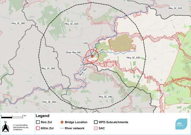
Executive summary
This report presents a Natura Impact Statement (NIS) for the replacement of a box culvert
bridge UB1 on Channel C1/46, Chainage 200, near Coonainra, Co Mayo in the Moy Arterial
Drainage Scheme. The scheme implements the legal duty on the OPW under the Arterial
Drainage Acts of 1945 and 1995 to maintain structures that form part of the scheme and
provide drainage and flood protection to the benefiting lands.
The project assessed is to demolish and remove an existing box culvert bridge structure
and construction of new box culvert. This is beyond the scope of works considered in the
existing NIS for the Moy Arterial Drainage Scheme (JBA Consulting, 2016; 2020) so is
subject to a separate Appropriate Assessment.
A desk-based assessment was used to identify the baseline ecological conditions on and
adjacent to the scheme channels.
The project zone of influence was determined using a modified version of the Ryan Hanley
screening method (Ryan Hanley, 2014a). This screening method was prepared specifically
for arterial drainage schemes based on experience of the impact of their implementation.
The screening uses variable distances depending on pathways of impact. The screening
process considered impact pathways via surface water, land and air, but not groundwater.
Groundwater pathways were excluded given the proximity to surface water.
In carrying out a Stage 1 Appropriate Assessment Screening, a total of one European site
was assessed as coming within the zone of influence of the project. As a result of the
screening, this site, the River Moy Special Area of Conservation, is brought forward to
Stage 2 Appropriate Assessment. Details of the site are presented including qualifying
interest features, conservation objectives and threats and pressures.
A detailed assessment of potential adverse impacts was carried out following the Ryan
Hanley Source-Receptor-Pathway approach developed for arterial drainage schemes but
expanded to deal with the specific issues relating to culvert maintenance. The assessment
identified a number of pathways to impact including increased suspended solids and
release of nutrients/pollutants.
Avoidance and reduction measures are suggested for the works and these are sufficient to
avoid and mitigate all effects of the project. The residual impact is considered in-
combination with other plans or projects. No in-combination impacts were identified which
would require further avoidance or mitigation.
The NIS has concluded that with the avoidance and mitigation measures proposed the
project to replace the box culvert bridge would not have a significant adverse impact on
the integrity of any European sites, in light of its conservation objectives and best scientific
knowledge, either alone or in combination with other plans or projects.

DJF-JBAI-XX-XX-RP-BD-0036-S3-P02-Bridge_Moy_C1-46_UB1_NIS                             ii

Contents
1        Introduction                                         1
1.1      Background                                           1
1.2      Legislative Context                                  1
1.3      Appropriate Assessment Process                       1
1.4      Structure of this report                             3
2        Methodology                                          4
2.1      Desktop Survey                                       4
2.2      Screening Method                                     5
2.3      Impact Assessment Method                             5
2.4      In-combination Assessment                            6
2.5      Consultation                                         6
2.6      Competent Persons                                    6
2.7      Limitations and Constraints                          7
3        Project Description                                  8
3.1      The ‘Project’                                        8
3.2      Project Location                                     8
3.3      Description of Project Activities                    9
3.4      Project Zone of Influence                           12
4        Ecology Baseline                                    13
4.1      Overview                                            13
4.2      Qualifying interests                                13
4.3      Surrounding landscape and habitat                   13
4.4      Non-native Invasive Species                         13
5        Screening Assessment                                14
5.1      Surface Water Pathways                              14
5.2      Land and air pathways                               16
5.3      Groundwater pathways                                17
5.4      Screening assessment conclusion                     17
6        European Sites                                      19
6.1      River Moy SAC (002298)                              19
7        Stage 2 Appropriate Assessment                      23
7.1      Introduction                                        23
7.2      Identification of Potential Sources of Impact       23
7.3      Impact Evaluation                                   25
7.4      Site specific mitigation measures                   29
7.5      Impact on Site Integrity                            29
8        Other Relevant Plans and Projects                   32
8.1      Cumulative effects                                  32
8.2      Plans                                               32
8.3      Projects                                            33
9        Conclusion                                          34
9.1      Potential Impacts                                   34
9.2      Cumulative Impacts                                  34
9.3      Summary                                             34
References                                                   37

DJF-JBAI-XX-XX-RP-BD-0036-S3-P02-Bridge_Moy_C1-46_UB1_NIS   iii
List of Figures
Figure    1-1: The Appropriate Assessment Process                                          2
Figure    3-1 Location of bridge UB1 in Moy Catchment                                      8
Figure    4-1: Channel C1/46 and box culvert bridge UB1. (Image provided by OPW).         13
Figure    5-1: European sites surface water catchment and pathway and 600m buffer
for Air   impacts.                                                                        14

List of Tables
Table 3-1. Summary of project impacts                                                      9
Table 3-2: Relevant Drainage Maintenance Procedures and whether these are a
description of the project, or mitigation measures                                        10
Table 5-1: Surface Water Pathways                                                         15
Table 5-2: Summary results of SWD QIs of SACs with potential surface water
pathways, potential Annex I habitats present and potential for significant impact         15
Table 5-3: Land and air pathways                                                          16
Table 5-4: Summary results of QIs / FOIs with potential land and air connectivity         16
Table 5-5 Conclusions of screening assessment for likelihood of significant effect        18
Table 7-1 Impact evaluation table for screened in QI/SCI and pathways                     26
Table 7-2. Specific mitigation measures                                                   29
Table 7-3: Integrity of Site Checklist- Conservation Objectives                           30
Table 7-4: Integrity of Site Checklist- Other Objectives                                  30

DJF-JBAI-XX-XX-RP-BD-0036-S3-P02-Bridge_Moy_C1-46_UB1_NIS                            iv
Abbreviations
AA                      Appropriate Assessment
CIEEM                   Chartered Institute of Ecology and Environmental Management
CO                      Conservation Objectives
DoEHLG                  Department of the Environment, Heritage and Local Government
EC                      European Community
EIA                     Environmental Impact Assessment
EP                      Environmental Procedures
EPA                     Environmental Protection Agency
IFI                     Inland Fisheries Ireland
IROPI                   Imperative Reasons of Overriding Public Interest
IUCN                    International Union for Conservation of Nature
I-WeBS                  Irish Wetland Bird Survey
LSE                     Likely Significant Effect
NIS                     Natura Impact Statement
NBDC                    National Biodiversity Data Centre
NNIS                    Non-Native Invasive Species
NPWS                    National Parks and Wildlife Services
OPW                     Office of Public Works
RBMP                    River Basin Management Plan
SAC                     Special Area of Conservation
SPA                     Special Protection Area
SWD                     Surface Water Dependant
QI                      Qualifying Interests
WFD                     Water Framework Directive
ZOI                     Zone of Influence

DJF-JBAI-XX-XX-RP-BD-0036-S3-P02-Bridge_Moy_C1-46_UB1_NIS                      v
1 Introduction

   1.1   Background
         JBA Consulting has been appointed by the Office of Public Works (OPW) to undertake an
         Appropriate Assessment of the effects of a project to demolish and remove an existing
         box culvert bridge structure and construct a new box culvert bridge at a box culvert
         bridge UB1 on Channel C1/46, Chainage 200, near Coonainra, Co Mayo.
         This Natura Impact Statement (NIS) documents the Appropriate Assessment process
         and results to enable the competent authority to undertake an appropriate assessment
         in accordance with Article 6(3) of the Habitats Directive (Council Directive 92/43/EEC on
         the conservation of natural habitats and of wild fauna and flora) and Regulation 42 of
         the Birds and Natural Habitats Regulations 2011 (as amended).
         The proposed project is part of the maintenance of the Moy Arterial Drainage Scheme,
         required as part of maintenance activities under the Arterial Drainage Acts of 1945 and
         1995. However, the proposed activities go beyond the scope of standard activities
         considered in the Moy Arterial Drainage Scheme NIS (JBA Consulting, 2016), an
         updated NIS for the coming 5 years is currently going through approval (JBA
         Consulting, 2021). Therefore, the proposed activities require separate assessment.

   1.2   Legislative Context
         The Habitats Directive (Directive 92/43/EEC) aims to maintain or restore the favourable
         conservation status of habitats and species of community interest across Europe. The
         requirements of Articles 6(3) and 6(4) of the Habitats Directive have been transposed
         into Irish legislation by means inter alia the European Communities (Birds and Natural
         Habitats) Regulations 2011 (S.I. No. 477 of 2011).
         Under the Directive a network of sites of nature conservation importance have been
         identified by each Member State as containing specified habitats or species requiring to
         be maintained or returned to favourable conservation status. In Ireland the network
         consists of Special Areas of Conservation (SACs) and Special Protection Areas (SPAs),
         and also candidate sites, which together form the Natura 2000 network.
         Article 6(3) of the Habitats Directive requires that, in relation to European designated
         sites (i.e. SACs and SPAs that form the Natura 2000 network), "any plan or project not
         directly connected with or necessary to the management of the site but likely to have a
         significant effect thereon, either individually or in combination with other plans or
         projects, shall be subject to appropriate assessment of its implications for the site in
         view of the site's conservation objectives".
         A competent authority (e.g. Local Authority) can only grant consent for a plan or project
         after having determined that it will not adversely affect the integrity of any European
         site, in light of its conservation objectives and best scientific evidence, either alone or in
         combination with other plans or projects.

   1.3   Appropriate Assessment Process
         Guidance on the Appropriate Assessment (AA) process was produced by the European
         Commission in 2002, which was subsequently developed into guidance specifically for
         Ireland by the Department of Environment, Heritage and Local Government (DoEHLG)
         (2009 rev 2010). These guidance documents identify a staged approach to conducting
         an AA, as shown in Figure 1-1. Stages 3 and 4 are necessary if a project is likely to
         have adverse impacts on European sites and are not discussed further here.

                                                                                                      1
DJF-JBAI-XX-XX-RP-BD-0036-S3-P02-Bridge_Moy_C1-46_UB1_NIS
Stage 1 Stage 3
Stage 2 Stage 4
Screening Alternative
AA IROPI
for AA Solutions
Figure 1-1: The Appropriate Assessment Process
1.3.1 Stage 1 - Screening for AA
The initial, screening stage of the Appropriate Assessment is to determine:
a) whether the proposed plan or project is directly connected with, or necessary
for, the management of the European designated site for nature conservation
b) if it is likely to have a significant adverse effect on the European designated
site, either individually or in combination with other plans or projects
For those sites where potential adverse impacts are identified, either alone or in
combination with other plans or projects, further assessment is necessary to determine
if the proposals will have an adverse impact on the integrity of a European designated
site, taking into account the sites conservation objectives (i.e. the process proceeds to
Stage 2).
1.3.2 Stage 2 - AA
This stage requires a more in-depth evaluation of the plan or project, and the potential
direct and indirect adverse impacts arising from it on the integrity and the interest
features of the European designated site(s), alone and in-combination with other plans
and projects, taking into account the site's structure, function and conservation
objectives and best scientific knowledge in the field. Where required, mitigation or
avoidance measures will be added to the project.
The competent authority can only grant consent for the plan or project after having
ascertained that it will not adversely affect the integrity of any European site, in light of
its conservation objectives and best scientific evidence, either alone or in combination
with other plans or projects after avoidance and mitigation measures have been applied
(if necessary) and the measures are capable of being, and certain to be, successfully
implemented. If this cannot be determined then alternative solutions will need to be
considered (i.e. the process proceeds to Stage 3).
1.3.3 Recent judgements of the Court of Justice of the European Union (CJEU)
and how they are used in this assessment
The CJEU issued a ruling on the consideration of avoidance and reduction measures as a
result of the case known as People over Wind, Peter Sweetman v Coillte Teoranta (Case
C-323/17). This judgement stated that measures intended to reduce or avoid effects on
a European site should only be considered within the framework of an Appropriate
Assessment, and it is not permissible to take into account such measures at the
screening stage. In practice, this means that any activities that are not integral to the
project (i.e. the project could conceivably take place without them) and have the effect
of avoiding or reducing an impact on a European site, cannot be considered at the
screening stage.
The CJEU ruling in the case of Grace & Sweetman [2018] (C-164/17) clarified the
difference between avoidance and reduction (mitigation) measures and compensation.
Measures intended to compensate for the negative effects of a project cannot be taken
into account in the assessment of the implications of a project, and instead are
considered under Article 6(4). This means that any project where an effect on the
integrity of a European site remains and can only be offset by compensation, would
2
DJF-JBAI-XX-XX-RP-BD-0036-S3-P02-Bridge_Moy_C1-46_UB1_NISneed to proceed under Article 6(4), demonstrating “imperative reasons of overriding
public interest”.
The judgements referred to as the Dutch Nitrogen cases [2018] (C-293/17 and C-
294/17) have important implications for projects that could potentially impact on sites
that are exceeding critical thresholds for input of damaging ammonia (but could also
reasonably apply where other nutrients are impacting European sites). The judgements
state that the use of thresholds to exclude project impacts is acceptable in principle, and
that strategic plans can be used as mitigation but only with consideration of the
certainty (or otherwise) of the outcomes of those strategic plans. It clarifies that where
the status of a habitat type is already unfavourable the possibility of authorising
activities which increase the problem is necessarily limited.
The CJEU ruling in the case of Holohan v An Bord Pleanala (C-462/17) also clarified the
importance in Appropriate Assessment of taking into account habitat types and species
outside the boundary of the European site where implications of the impacts on those
habitat and species may impact the conservation objectives of the European site. In this
assessment functionally linked and supporting habitat for species outside of European
sites are assessed where they could potentially impact the conservation objectives of
any screened in European sites.
1.4 Structure of this report
In order to provide the competent authority with the relevant information to determine
with confidence their conclusions on the overall impacts of the project to the integrity of
the European sites concerned, this NIS presents the following:
• Section 2: Details of the methods used in this assessment.
• Section 3: A detailed description of the proposed project and its Zone of
Influence.
• Section 4: A detailed description of the baseline conditions within the area of
works.
• Section 5: A screening of European sites based on those that are located within
the Zone of Influence (ZOI) of the proposed works.
• Section 6: A description of those European sites that are screened in for being at
risk for potential adverse impacts from the proposed works.
• Section 7: Identification of potential sources of impact to the screened in
European sites and assessment of the impacts for significance. Where effects are
present specific mitigation is proposed.
• Section 8: Assessment of cumulative and/or in-combination impacts where non-
significant effects are present.
• Section 9: Summary of the impacts and mitigation with overall assessment on
the coherence of the European network.
3
DJF-JBAI-XX-XX-RP-BD-0036-S3-P02-Bridge_Moy_C1-46_UB1_NIS2 Methodology
This NIS has been prepared having regard to the Birds and Habitats Directives, the
European Communities (Birds and Natural Habitats) Regulations 2011-15 as amended
and relevant jurisprudence of the EU and Irish courts. The following documents have
also used to provide guidance during the assessment:
• DoEHLG (2009) Appropriate Assessment of Plans and Projects in Ireland
Guidance for Planning Authorities. Department of the Environment, Heritage
and Local Government. Revised 2010.
• European Commission (EC) (2019) Managing Natura 2000 Sites: the
provisions of Article 6 of the ‘Habitats’ Directive 92/43/EEC, Office for Official
Publications of the European Communities, Luxembourg. European
Commission.
• EC (2002) Assessment of Plans and Projects Significantly Affecting Natura
2000 Sites: Methodological guidance on the provisions of Article 6(3) and (4)
of the Habitats Directive 92/43/EEC, Office for Official Publications of the
European Communities, Luxembourg. European Commission.
• EC (2013) Interpretation Manual of European Union Habitats. Version EUR 28.
European Commission.
• Fossitt (2000). A Guide to Habitats in Ireland. The Heritage Council, Kilkenny.
• Guidelines for Ecological Impact Assessment in the UK and Ireland -
Terrestrial, Freshwater and Coastal, Second Ed. (Chartered Institute of
Ecology and Environmental Management (CIEEM), 2018)
2.1 Desktop Survey
A desktop survey was conducted of available published and unpublished information,
along with a review of data available on the National Parks and Wildlife Service (NPWS)
and National Biodiversity Data Centre (NBDC) web-based databases, in order to identify
key habitats and species (including legally protected and species of conservation
concern) that may be present within ecologically relevant distances from the scheme as
explained below. The data sources below were consulted for the desktop study:
• NBDC species data within 2km of the scheme channels, within the past 10
years.
• NPWS website (www.npws.ie), (https://www.npws.ie/), where site synopses,
Natura 2000 data forms and conservation objectives were obtained along with
Annex I habitat distribution data and status reports.
• NBDC Maps (http://maps.biodiversityireland.ie/#/Map)
• (NPWS 2019a). The Status of EU Protected Habitats and Species in Ireland.
Volume 1: Summary Overview. Unpublished NPWS report.
• NPWS (2019b). The Status of EU Protected Habitats and Species in Ireland.
Volume 2: Habitat Assessments. Unpublished NPWS report.
• NPWS (2019c). The Status of EU Protected Habitats and Species in Ireland.
Volume 3: Species Assessments. Unpublished NPWS report.
• Environmental Protection Agency (EPA) maps website
(https://gis.epa.ie/EPAMaps/)
• BirdWatch Ireland (www.birdwatchireland.ie)
• Bird survey data from the waterbird survey programme and the Irish Wetland
Bird Survey (I-WeBS)
• 5-year NIS for Moy Arterial Drainage Maintenance Scheme (JBA Consulting
2016; 2021)
4
DJF-JBAI-XX-XX-RP-BD-0036-S3-P02-Bridge_Moy_C1-46_UB1_NIS2.2 Screening Method
The screening method follows closely the method developed to screen impacts of
Arterial Drainage Schemes by (Ryan Hanley, 2014a). The method sets out a series to 10
steps for identifying possible adverse impacts via surface water, land and air, and
groundwater pathways. The steps identify the widest possible zone of influence then
gradually screen out sites on the basis of distance, susceptibility of QI to each pathway
and particular conditions that would allow adverse impacts to be conveyed between the
project and the European site. However, the Ryan Hanley method is designed for the
large-scale maintenance activities, rather than discrete projects located in a small area
and with a limited footprint. Some of the steps in the Ryan Hanley method were
therefore simplified or removed to account for this difference.. Groundwater effects
were considered only where the project requires excavation below existing bed levels or
where piling or other operations likely to impact bedrock are included. The screening
method has been updated to take into account environmental procedures (EP) which
are considered part of the project description, that is they will be implemented
regardless of setting and there is high confidence in their effectiveness. Some EPs are
implemented only in specific locations, so these are not considered part of the project
description. In particular the impacts of the implementation EP7 and EP10, which are
always completed, prevent impacts related to poor-practice for vegetation and silt
management respectively. The OPW implements a programme of training and audit
which ensures these EPs are implemented with a high degree of confidence allowing
them to be included with certainty as part of the project description.
2.3 Impact Assessment Method
The assessment used the source-pathway-receptor model which is a conventional model
used for determining the risk of impact to a site or qualifying interest (CIEEM, 2018).
For Arterial Drainage Schemes this is implemented using the guidance provided by
(Ryan Hanley, 2014b) which is developed to examine the specific impacts related to the
Arterial Drainage Schemes.
Risk is the likelihood or expected frequency of a specified adverse consequence or
impact. Applied to the Habitats Directive and the Arterial Drainage Maintenance
programme, it expresses the likelihood of an adverse impact arising as a result of the
proposed works and associated activities. The proposed works or activities that may
occur as a result of the Arterial Drainage Maintenance programme can be considered a
potential hazard. A hazard presents a risk when it is likely to affect something of value
(i.e. the European sites and their Qualifying Interests (QIs)). It is the combination of
the probability of the hazard of occurring and its consequences that is the basis of a risk
assessment which an NIS essentially is:
Risk = probability of an event x consequential damage
The source-pathway-receptor model is a useful tool for determine if a risk is present. In
order for a risk to be present, all three elements must be present.
Source: The source considered in this report, is the proposed works or activity that will
occur as a result of the Arterial Drainage Maintenance programme. Key considerations
in assessing the source are the nature and scale of the potential impacts that may arise
such as the type of contaminants that may arise, the contaminant loading and other
physical attributes. The point of occurrence is a critical reference point for assessing the
attributes of the Source of any potential adverse impacts.
Pathway: Pathways are established by surface water, groundwater and land and air
connections. The pathway includes everything between the source and the receptor;
from point of release of potential adverse impacts, such as contaminants, to the
receptor. The location, nature, connectivity and extent of wells, groundwater dependent
ecosystems, aquifers and faults can all influence the nature of a pathway. Rivers,
streams and drainage ditches could all act as potential pathways for potential
waterborne impacts. Land and air pathways to be considered include those that may
5
DJF-JBAI-XX-XX-RP-BD-0036-S3-P02-Bridge_Moy_C1-46_UB1_NIStransfer direct physical impacts, noise and visual disturbance (vibrations) and dust or
other airborne particles.
Receptor: The receptor is the qualifying interests of the relevant European sites, their
Conservation Objectives (COs) and the overall integrity of the European sites. While the
competent authority should only agree to the plan or project after having ascertained
that it will not adversely affect the integrity of the site concerned. In order to determine
the significance of any potential adverse impacts that may occur that may adversely
affect the integrity of the European site, the COs of each site are assessed relative to
the potential impacts that may occur as a result of the proposed works. Each European
site will either have specific or generic conservation objectives. Detailed site-specific
COs have been provided for some of SACs and SPAs, which can be found within the CO
document for each site on the NPWS website and Appendix A. Generic conservation
objectives have been compiled for the remaining SACs and SPA based on COs for the
same species or habitats in SACs and SPAs with similar characteristics.
The overall aim of COs is to maintain or restore the favourable conservation conditions
of the Annex I habitats and/or the Annex II species for which a SAC or SPA has been
selected, under which the site-specific objectives contain more detailed attributes,
measures and targets. There are a set of generic COs for species and habitats. For some
sites these have been developed into site-specific objectives.
2.4 In-combination Assessment
The in-combination assessment is based on the process developed by DTA Ecology
(Tyldesley and Chapman, 2013). If a project has no impacts alone, there is no feasible
pathway for in-combination impacts. However, if there are residual impacts, even ones
that would not cause likely significant effects then an in-combination assessment will be
completed. The assessment method was based on searching for plans and projects,
including the ongoing OPW Arterial Drainage Scheme works, where the bridge works
could have residual impacts that may be increased in-combination with other projects.
Where these impacts were identified, the relevant screening distance for the impact
pathway from Ryan Hanley (2014a) was applied to European site. Within this screening
distance any plans and projects were searched for. If the plan or project had a
published Appropriate Assessment which was not subject to a further information
request, this was reviewed for possible in-combination impacts. If this NIS concluded no
impacts (including no non-significant residual impacts) alone, the plan or project was
ruled out of the in-combination assessment, and this is noted in the text. If the AA
included potential residual impacts, or if it was subject to a further information request,
then it was taken forward for impact assessment in-combination with the arterial
drainage scheme.
2.5 Consultation
No formal consultations have been taken on the proposed works. The draft of this NIS
should be subject to consultation with NPWS as the Statutory Nature Conservation Body
for Ireland.
2.6 Competent Persons
The assessment has been carried out by JBA ecologists Malin Lundberg (BSc, MSc) and
Hannah Mulcahy (BSc (Hons), MSc). They have both undertaken Appropriate
Assessment reports and NIS assessments for a variety of schemes in Ireland as well as
assessment of projects under Article 6 of the Habitats Directive in a range of European
countries. The assessment has been reviewed by Dr Steven Heathcote BA(Hons) DPhil
MCIEEM, a Senior Ecologist with over 10 years' consultancy experience in undertaking
assessments under the Habitats Directive.
6
DJF-JBAI-XX-XX-RP-BD-0036-S3-P02-Bridge_Moy_C1-46_UB1_NIS2.7 Limitations and Constraints
The conclusion of this report necessarily relies on some assumptions and it is inevitably
subject to some limitations. Most of the assumptions and limitations would not affect
the conclusion but the following points are recorded to ensure the basis of the
assessment is clear:
• The assessment did not involve any field surveys by an ecologist and is based on
existing data and information provided by site operatives. Information obtained
from the desk sources including aerial images and site photographs is typically
sufficient to inform the screening but where necessary the precautionary
principle has been applied in assessing habitat condition and potential presence
of mobile species.
7
DJF-JBAI-XX-XX-RP-BD-0036-S3-P02-Bridge_Moy_C1-46_UB1_NIS3 Project Description
3.1 The ‘Project’
The proposed demolition and removal of an existing box culvert bridge structure and
construction of new box culvert bridge meets the criteria of a 'Project' as defined in the
European Communities (Birds and Natural Habitats) Regulations 2011, as amended and
is not directly connected with or necessary to the management of any European site.
Therefore it is subject to the requirements of the Appropriate Assessment process.
The OPW is statutorily obligated to maintain arterial drainage channels under the 1945
and 1995 Arterial Drainage Acts, and since their completion, maintenance of these
Arterial Drainage Schemes has been ongoing. Significant works not included in the
standard maintenance are subject to separate assessment, as is the case with these
proposed bridge replacements.
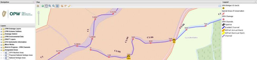
3.2 Project Location
The proposed works will include the demolition and removal of an existing box culvert
bridge structure and construction of new box culvert bridge UB1 on C1/46, Chainage
200, near Coonainra, Co Mayo (GPS coordinates 53.994, -8.896). The channel will be
dammed so that works can be carried out in the dry, and the water will either be
diverted through a channel, or over-pumped.
Channel C1/46 is an unnamed minor stream which enters the River Moy 190m
downstream from the bridge .
The site compound will be located in an agricultural field just off an unnamed minor
public road (Figure 3-1).
Figure 3-1 Location of bridge UB1 in Moy Catchment
8
DJF-JBAI-XX-XX-RP-BD-0036-S3-P02-Bridge_Moy_C1-46_UB1_NIS3.3 Description of Project Activities
The method statement, compiled by OPW, for the demolition and removal of an existing
box culvert bridge structure and construction of new box culvert bridge is included in
Appendix A. The potential sources of impact from the method statement are
summarised in Table 3-1.
Table 3-1. Summary of project impacts
Project Elements Comment
Size and scale The works include demolition and removal of an existing box
culvert bridge structure and construction of new box culvert
bridge, designed in accordance with the OPW Standard Design.
The works area will be de-watered by using one of two options.
One option is to dam and create a diversion channel, which
would be excavated from a point upstream of the existing bridge
and tie back into the channel at a point downstream. The other
option is to dam and pump water onto grassland for natural
filtration. Which method will be used will be based on ground
conditions and flow rates.
This operation is a relatively small-scale and localised operation
compared to standard OPW works.
Land-take There would be no permanent land take, with all operations
being temporary. The temporary land-take would be a small
area of compound and material storage for the demolition and
replacement of the existing bridge.
Surrounding area will be reinstated following completion of
works.
Distance from The bridge is located in the River Moy SAC (002298)
European site or key
features of the site
Resource The resources and materials used in the proposed works will be
requirements (water imported from off site.
abstraction etc.) The channel will be de-watered in the works area but the water
will not be permanently abstracted.
Emissions (disposal to There will be a small quantity of airborne emissions from
land, water or air) construction vehicles, but these will be negligible.
No other emissions are anticipated.
Excavation Excavations may be made if diversion of the channel is required
requirements if damming and over pumping of the waterbody cannot be
carried out. If a channel diversion is to take place this will be
carried out on the left bank from a point upstream of the
existing bridge and will tie back into the channel at a point
downstream of the bridge. The bypass channel will be no deeper
than the bed level of the existing river.
The area around the existing bridge will be excavated to a
suitable width and depth as per the requirements of the new
bridge design.
The surrounding area will be reinstated when the works are
complete.
Transportation There will be a requirement to transport material and vehicles to
requirements the site along existing access routes.
Duration of The duration of works at this site are estimated to last for
construction, approximately 4 - 5 weeks (16 – 20 man weeks), to be
9
DJF-JBAI-XX-XX-RP-BD-0036-S3-P02-Bridge_Moy_C1-46_UB1_NISoperation, undertaken during summer months. The existing bridge will be
decommissioning etc. demolished and materials removed from site.
In-channel works In order to demolish and replace the bridge, the channel will be
de-watered. The method of de-watering the works area will be
decided upon after mobilisation to site. Consideration will be
given to ground conditions and flow rates. The options will be
damming and diversion channel or damming and over-pumping.
Other C1/46 is a Salmond Channel that outfalls into C1 River Moy
190m downstream
3.3.1 Works Access
The bridge is accessed via local unnamed public road and through agricultural land (see
Figure 3-1).
3.3.2 Timing of Works
The duration of works at this site are estimated to last for approximately 4 - 5 weeks
(16 – 20 man weeks). It is intended to carry out the works in summer months at times
of low flow and when the land surrounding the bridge is at its most dry.
3.3.3 Guidance for Drainage Maintenance Activities
The OPW Environmental Guidance: Drainage Maintenance and Construction (Brew and
Gilligan, 2019) sets out how Drainage Maintenance and Construction work is to be
carried out. The guidance document includes procedures which are instructions to help
OPW staff, in the form of a practical handbook. The Guidance aims to deliver good
drainage and flood relief functions while reducing the associated environmental impacts.
The Environmental Procedures (EPs) set out in this book include a range of standard
mitigation and are compulsory on OPW projects. These compulsory EPs provide a basic
level of Environmental Mitigation, and are considered to be embedded in the project, so
are included in the project description, rather than being considered as ‘avoidance or
reduction’ measures which could only be considered in the Appropriate Assessment
(Stage 2). Some EPs are not compulsory on all schemes and these are considered to be
‘avoidance or reduction’ measures and are not considered until later.
Table 3-2: Relevant Drainage Maintenance Procedures and whether these are a
description of the project, or mitigation measures
Procedure Project Notes
Description,
Mitigation, or
other
Section 1A: Drainage Maintenance Planning Procedures
EP1 Annual Programme Project Description Applies to all maintenance.
EP2 Environmental Risk Project Description Applies to all works to identify if included in
Assessment the project description of the Appropriate
Assessment.
EP5 Drainage Project Description This procedure is for communication of
Maintenance environmental management and any
Environmental mitigation measures with onsite staff and
Management others implementing drainage maintenance
activity.
10
DJF-JBAI-XX-XX-RP-BD-0036-S3-P02-Bridge_Moy_C1-46_UB1_NISProcedure Project Notes
Description,
Mitigation, or
other
Section 1B: Drainage Maintenance Implementation Procedures
EP7 Environmental Project Description This procedure describes how typical
Drainage Maintenance maintenance of channels and embankments
is to be carried out.
Included are some seasonal restrictions on
activities, which are requirements of other
legislation:
- No maintenance within coarse fish
channels from 1st April to 1st July.
- Tree cutting window from 1st September
to 28th February.
- Work in gravel bed channels only
between 1st July and 30th September.
The procedure also sets the annual audit
process of maintenance activity.
Section 2: Construction Procedures
EP15 Construction Silt Project Description Measures to ensure the reduction in artificial
Management sources of silt from total silt load of water
bodies includes consideration for set up and
operation with measures including silt
interception.
EP17 Water Pollution Project Description This procedure relates to all work
(maintenance and construction) beside water
bodies. It sets control measures to protect
water bodies from pollution sources
associated with works and machinery.
Section 3: Invasive Species Procedures
EP18A Standard Project Description This is a minimum requirement for all works.
Biosecurity
EP18B High Biosecurity Mitigation This procedure for enhanced biosecurity
measures is dependent upon location.
Section 4: Animal and Plant Procedures
EP19 Salmonid Mitigation GIS layers are used to identify if species are
likely to be encountered, however the species
EP20 Otter
could occur in locations not already identified.
EP21 Lamprey If species or habitats are observed by
EP22 Crayfish maintenance staff then the full procedure
applies.
EP23 Badger
These procedures only apply to certain
EP24 Bank Nesting Birds channels and embankments and so do not
EP25 Birds apply to all maintenance activity.
Seasonal restrictions are already set in EP7.
EP26 Bats
EP27 Rare Plants
EP28 Freshwater Pearl
Mussel
Habitat Procedures
EP30 Alluvial (Wet Mitigation GIS layers are used to identify if habitats are
Woodland) likely to be encountered, however the habitats
could occur in locations not already identified.
EP31 Wetland
If habitats are observed by maintenance staff
EP33 Floating River then the full procedure applies.
11
DJF-JBAI-XX-XX-RP-BD-0036-S3-P02-Bridge_Moy_C1-46_UB1_NISProcedure Project Notes
Description,
Mitigation, or
other
Vegetation Habitat These procedures only apply to certain
channels and embankments and so do not
apply to all maintenance activity.
3.3.4 Working Hours
All maintenance activities are undertaken during daylight hours. Standard working hours
are 8.00am to 4.30pm, with lunch and tea breaks, Monday to Friday. There is no
requirement for temporary site lighting to facilitate works. Machines are powered down
when not in use.
3.4 Project Zone of Influence
The project zone of influence for this screening is based on the screening tables in Ryan
Hanley (2014a). An initial screening is based on surface water catchments, groundwater
bodies or a physical footprint plus 600m buffer, that are used to identify sites with
potential ecological connectivity to the scheme, and subsequently these sites are
screened using the criteria for each pathway listed in Ryan Hanley (2014a,b) to
determine if there are any likely significant effects which need further consideration.
12
DJF-JBAI-XX-XX-RP-BD-0036-S3-P02-Bridge_Moy_C1-46_UB1_NIS4 Ecology Baseline
4.1 Overview
This section summarises the baseline information about the environment within the
project footprint. This is based on a review of the information listed in Section 2.1. No
site visit was carried out for this assessment.
4.2 Qualifying interests
Records from NBDC (2021) mapping were compiled to identify any Qualifying Interests
that may be recorded within 2km or located within the relevant catchment.
White-clawed Crayfish Austopotamobius pallipes has been recorded 1km away, at the
Gorteen Bridge on Ballinacurra stream, the next downstream tributary to C1/46.
Evidence of Otter Lutra lutra has been recorded at Ballinacurra in 1980s, approximately
300m downstream on the Moy. It was noted with this record that there was very little
vegetation for Otter. More recent records have been recorded downstream on the Moy,
and it is likely this species is present in channel C1/46.
The channel is identified as an important salmonid channel in OPW’s records.
4.3 Surrounding landscape and habitat
The surrounding landscape either side of bridge UB1 is dominated by agricultural fields,
some of the boundaries are bordered by treelines, although upstream of the bridge the
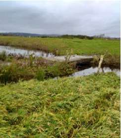
land is composed of forestry plantation and cutover bogs. The channel C1/46 is a minor
watercourse approximately 2m wide (Figure 4-1) with little riparian vegetation and
outfalls into the River Moy 190m downstream of the bridge.
Figure 4-1: Channel C1/46 and box culvert bridge UB1. (Image provided by
OPW).
4.4 Non-native Invasive Species
No Non-native Invasive Species (NNIS) were noted by OPW in the vicinity of the bridge.
13
DJF-JBAI-XX-XX-RP-BD-0036-S3-P02-Bridge_Moy_C1-46_UB1_NIS5 Screening Assessment
This Screening Assessment was conducted in line with guidance produced for the OPW
in 2014 (Ryan Hanley, 2014a; 2014b). This methodology is based on source > pathway
> receptor chain principles and involves assessing likely significant effects on European
sites within the zone of influence of the proposed drainage maintenance in relation to
three pathways:
1. Surface water
2. Land & air
3. Groundwater
The Screening involved assessing the potential impacts of drainage maintenance
operations within the arterial drainage scheme, and its zone of influence (ZOI), in
relation to each of the three pathways. The ZOI varies for each pathway in order to
ensure that only relevant site and impact combinations are considered. Although there
is no upper limit on the ZOI, it is rarely beyond 5km (Section 3.4) and for some land
and air impact pathways it is as little as 10m. Conclusions were then drawn to identify if
maintenance works could impact upon European sites.
Figure 5-1 below shows the surface water catchment and pathways from the site to the
European site.
Figure 5-1: European sites surface water catchment and pathway and 600m
buffer for Air impacts.
5.1 Surface Water Pathways
The surface water pathways are based on river catchments. The bridge is located
primarily within the Moy_SC_030 Water Framework Directive (WFD) sub-catchment.
14
DJF-JBAI-XX-XX-RP-BD-0036-S3-P02-Bridge_Moy_C1-46_UB1_NISRiver Moy SAC is the only European site within the same surface water catchment
within 5km as the bridge (Table 5-1). The European site has surface water connectivity
with the Scheme.
Table 5-1: Surface Water Pathways
European Site (Site Code) Is site within the Is there surface water
same surface connectivity with the
water catchment scheme?
as the scheme?
River Moy SAC (002298) Yes Yes
Pre-determined distances and typologies (Ryan Hanley, 2014b) were used to define the
ZoI of the works and determine potential and significance of impacts on individual QI
features of the site. Information, including from the Conservation Objectives, was also
reviewed to determine the location of the drainage maintenance activities relative to the
Surface Water Dependent (SWD) QIs. Where no information on the location of SWD
Qualifying Interests was available, the precautionary principle was applied and the QIs
were screened in. The results of this are summarised in Table 5-2 and show if a Likely
Significant Effect (LSE) will occur.
Table 5-2: Summary results of SWD QIs of SACs with potential surface water
pathways, potential Annex I habitats present and potential for significant
impact
SWD QI [EU Code] Project activity Desktop Study Conclusion
location relative to Comment
SWD QI
River Moy SAC (002298)
Alluvial forests with Alnus >5km away Along the channel No LSE
glutinosa and Fraxinus between Ballimore
excelsior (Alno-Padion, Alnion Lough and the main
incanae, Salicion albae) River Moy.
[91E0]
Alkaline fens [7230] >5km away Around Mannin Lake No LSE
and also adjacent to
the River Moy near
Ballintemple.
Austropotamobius pallipes Possibly present at site Widespread Potential LSE
White-clawed Crayfish [1092] throughout the SAC.
Petromyzon marinus Sea Possibly present at site Regularly recorded in Potential LSE
Lamprey [1095] the lower stretches
of River Moy around
Ballina.
Lampetra planeri Brook Possibly present at site Distribution not Potential LSE
Lamprey [1096] mapped.
Salmo salar Salmon [1106] Possibly present at site Widespread Potential LSE
throughout the SAC.
Lutra lutra Otter [1355] Possibly present at site Widespread Potential LSE
throughout the SAC.
The screening has identified that one European site is within the relevant screening
distances and could potentially be impacted via surface water pathways. In summary,
QIs of the following European sites are at risk from likely significant adverse effects and
require further assessment:
River Moy SAC
15
DJF-JBAI-XX-XX-RP-BD-0036-S3-P02-Bridge_Moy_C1-46_UB1_NIS• Austropotamobius pallipes White-clawed Crayfish [1092]
• Petromyzon marinus Sea Lamprey [1095]
• Lampetra planeri Brook Lamprey [1096]
• Salmo salar Salmon [1106]
• Lutra lutra Otter [1355]
5.2 Land and air pathways
The relevant ZoI for land and air pathways from drainage schemes is 0.01km to 0.6km
(Ryan Hanley, 2014b). As a result of this, the scheme has the potential to impact on the
European sites shown in Table 5-3 via Land and Air Pathways.
Table 5-3: Land and air pathways
European Site 0.6km Buffer Zone 0.01km (Overlap)
Name (Site Code)
Type of Impact Indirect impacts for noise and Direct impacts from physical
visual disturbance through air disturbance of habitats
pathways through land pathways
River Moy SAC Yes Yes
(002298)
The distribution of habitats is taken from a combination of published NPWS data.
Summary results of QIs with potential for likely significant effects by land and air
pathways are shown for the Natura site in Table 5-4.
Table 5-4: Summary results of QIs / FOIs with potential land and air
connectivity
Land and Air QI Project activity Desktop Study Conclusion
location relative Comment
to QI
Lough Corrib SAC
Old sessile oak woods with >0.6km/0.01km Mapped on west No LSE
Ilex and Blechnum in the away edge of Lough Conn
British Isles [91A0]
Active raised bogs [7110] >0.6km/0.01km There are five raised No LSE
away bogs listed for River
Moy SAC.
Cloongoonagh Bog is
located 1.8km away
Degraded raised bogs still >0.6km/0.01km Associated with No LSE
capable of natural away Active Raised Bogs
regeneration [7120] [7110]
Depressions on peat >0.6km/0.01km Associated with No LSE
substrates of the away Active Raised Bogs
Rhynchosporion [7150] [7110]
Lowland hay meadows >0.6km/0.01km Listed as a QI but no No LSE
(Alopecurus pratensis, away conservation
Sanguisorba officinalis) objective exists.
[6510] Located near Foxford
Alluvial forests with Alnus >0.6km/0.01km Mapped on west No LSE
glutinosa and Fraxinus away edge of Lough Conn
excelsior (Alno-Padion, Alnion
incanae, Salicion albae)
[91E0]
16
DJF-JBAI-XX-XX-RP-BD-0036-S3-P02-Bridge_Moy_C1-46_UB1_NISLand and Air QI Project activity Desktop Study Conclusion
location relative Comment
to QI
Alkaline fens [7230] >0.6km/0.01km Around Mannin Lake No LSE
away and also adjacent to
the River Moy near
Ballintemple.
Austropotamobius pallipes Possibly present at Widespread Potential LSE
White-clawed Crayfish [1092] site throughout the SAC.
Petromyzon marinus Sea Possibly present at Regularly recorded in Potential LSE
Lamprey [1095] site the lower stretches
of River Moy around
Ballina.
Lampetra planeri Brook Possibly present at Distribution not Potential LSE
Lamprey [1096] site mapped.
Salmo salar Salmon [1106] Possibly present at Widespread Potential LSE
site throughout the SAC.
Lutra lutra Otter [1355] Possibly present at Widespread Potential LSE
site throughout the SAC.
The screening has identified that one European site is within the relevant screening
distances and could potentially be impacted via land and air pathways. In summary, QIs
of the following European sites are at risk from likely significant adverse effects and
require further assessment:
River Moy SAC
• Austropotamobius pallipes White-clawed Crayfish [1092]
• Petromyzon marinus Sea Lamprey [1095]
• Lampetra planeri Brook Lamprey [1096]
• Salmo salar Salmon [1106]
• Lutra lutra Otter [1355]
5.3 Groundwater pathways
The proposed project primarily involves working at a watercourse or next to a
watercourse. Excavations will be no deeper than existing level of the riverbed. Any
water discharged locally to the ground would drain to the stream and return to surface
and would not enter the groundwater body in significant quantity. This means that the
potential for impacts to be transmitted via groundwater are negligible and groundwater
impacts are screened out from further assessment.
5.4 Screening assessment conclusion
The screening assessment identified one European site within the ZOI of the Scheme.
The screening assessed this site for potential for significant impacts from the proposed
works of the Scheme, using the source-pathway-receptor model (Ryan Hanley, 2014a)
and identified that there are likely significant effects requiring further assessment on the
River Moy SAC (Table 5-5). An Appropriate Assessment is therefore required.
17
DJF-JBAI-XX-XX-RP-BD-0036-S3-P02-Bridge_Moy_C1-46_UB1_NISTable 5-5 Conclusions of screening assessment for likelihood of significant
effect
Site Pathway of Impact Comment
Surface Land and Ground
Water Air water
River Moy SAC Yes Yes No There is potential for the QIs
(002298) of this European site to be
impacted by surface water
and land and air pathways
given that the species
present have connectivity to
surface water and are likely
to occur throughout the SAC.
18
DJF-JBAI-XX-XX-RP-BD-0036-S3-P02-Bridge_Moy_C1-46_UB1_NIS6 European Sites
Two sites were identified by the Screening Assessment as having likely significant
effects as a result of proposed bridge repair. This section presents more detail on the
sites and its QIs, with details of the conservation objectives given in Appendix A. These
were already taken into account in the screening assessment but are presented here to
provide full clarity on the basis for the Stage 2 assessment.
6.1 River Moy SAC (002298)
The River Moy SAC comprises almost the entire freshwater element of the River Moy
and its tributaries including Lough Conn and Lough Cullin. The system drains a
catchment area of 805 km2. The largest area of the SAC is located in Co. Mayo,
although parts are in west Sligo and north Roscommon. Apart from the River Moy itself,
other rivers included within the site are the Deel, Bar Deela, Castlehill, Addergoole,
Clydagh and Manulla on the west side, and the Glenree, Yellow, Strade, Gweestion,
Trimogue, Sonnagh, Mullaghanoe, Owengarve, Eighnagh and Owenaher on the east
side. The underlying geology is Carboniferous Limestone for the most part, though
Carboniferous Sandstone is present at the extreme west of the site, with Dalradian
Quartzites and schists at the south-west. Some of the tributaries at the east, the south
of Lough Conn and all of Lough Cullin are underlain by granite. There are many towns
adjacent to but not within the site. These include Ballina, Crossmolina, Foxford,
Swinford, Kiltimagh and Charlestown (NPWS, 2020b).
The River Moy and Lough Conn are one of Irelands premier Salmonid river and lake
systems (NPWS 2020b).
6.1.1 Qualifying interests
River Moy SAC is selected for the following seven habitats and five species listed on
Annex I / II of the E.U. Habitats Directive (* = priority; numbers in brackets are
European codes) (NPWS, 2016):
• Lowland hay meadows (Alopecurus pratensis, Sanguisorba officinalis) [6510]
• Active raised bogs [7110]*
• Degraded raised bogs still capable of natural regeneration [7120]
• Depressions on peat substrates of the Rhynchosporion [7150]
• Alkaline fens [7230]
• Old sessile oak woods with Ilex and Blechnum in the British Isles [91A0]
• Alluvial forests with Alnus glutinosa and Fraxinus excelsior (Alno-Padion,
Alnion incanae, Salicion albae) [91E0]*
• Austropotamobius pallipes White-clawed Crayfish [1092]
• Petromyzon marinus Sea Lamprey [1095]
• Lampetra planeri Brook Lamprey [1096]
• Salmo salar Salmon [1106]
• Lutra lutra Otter [1355]
Not all of the qualifying features of the SAC occur in the ZoI of the proposed works. The
QIs that could be potentially present in the vicinity and therefore have the potential to
be significantly impacted through water quality and/or disturbance include:
• Austropotamobius pallipes White-clawed Crayfish [1092]
• Petromyzon marinus Sea Lamprey [1095]
• Lampetra planeri Brook Lamprey [1096]
• Salmo salar Salmon [1106]
19
DJF-JBAI-XX-XX-RP-BD-0036-S3-P02-Bridge_Moy_C1-46_UB1_NIS• Lutra lutra Otter [1355]
6.1.2 Site Vulnerabilities
The main threats to the quality of this site are from water polluting activities resulting
from intensification of agricultural activities and diffuse pollution to surface waters due
to agricultural activities, including spreading of slurry and fertilisers, and forestry
activities resulting in sedimentation and acidification. Introduction of invasive non-
native species, such as exotic crayfish species or the crayfish fungal plague
(Aphanomyces astaci) could have a serious impact on the native crayfish population.
(NPWS, 2020a; 2020b)
6.1.3 Conservation Objectives
The conservation objectives for the qualifying interests of the SAC that are of relevance
to this NIS are detailed the following sections.
6.1.3.1 White-clawed Crayfish Austropotamobius pallipes
White-clawed Crayfish is widespread throughout River Moy SAC, including the
tributaries of River Moy (NPWS, 2020b). The conservation objectives for this species are
to maintain the favourable conservation condition of White-clawed Crayfish in River Moy
SAC, which is defined by the following list of attributes and targets:
Attribute Measure Target
Distribution Occurrence No reduction from baseline
Population structure: Occurrence of juveniles Juveniles and/or females
recruitment and females with eggs with eggs in all occupied
tributaries
Negative indicator species Occurrence No alien crayfish species
Disease Occurrence No instances of disease
Water quality EPA Q value At least Q3-4 at all sites
sampled by EPA
Habitat quality: Occurrence of positive No decline in
heterogeneity habitat features heterogeneity or habitat
quality
6.1.3.2 Sea Lamprey Petromyzon marinus
Sea Lamprey is regularly encountered in the lower stretches of the river around Ballina
(NPWS, 2020b). The conservation objectives for this species are to maintain the
favourable conservation condition of Sea Lamprey in River Moy SAC, which is defined by
the following list of attributes and targets:
Attribute Measure Target
Distribution: extent of Percentage of river Greater than 75% of main
anadromy accessible stem length of rivers
accessible from estuary
Population structure of Number of age/size groups At least three age/size
juveniles groups present
Juvenile density in fine Juveniles/m² Mean catchment juvenile
sediment density at least 1/m²
Extent and distribution of m² and occurrence No decline in extent and
spawning habitat distribution of spawning
beds
20
DJF-JBAI-XX-XX-RP-BD-0036-S3-P02-Bridge_Moy_C1-46_UB1_NISAttribute Measure Target
Availability of Number of positive sites in More than 50% of sample
juvenile habitat 3rd order channels (and sites positive
greater), downstream of
spawning areas
6.1.3.3 Brook Lamprey Lampetra planeri
The conservation objectives for this species are to maintain the favourable conservation
condition of Brook Lamprey in River Moy SAC, which is defined by the following list of
attributes and targets:
Attribute Measure Target
Distribution Percentage of river Access to all watercourses
accessible down to first order streams
Population structure of Number of age/size At least three age/size groups
juveniles groups of brook/river lamprey present
Juvenile density in fine Juveniles/m² Mean catchment juvenile
sediment density of brook/river lamprey
at least 2/m²
Extent and distribution of m² and occurrence No decline in extent and
spawning habitat distribution of spawning beds
Availability of juvenile Number of positive More than 50% of sample sites
habitat sites in 2nd order positive
channels (and
greater), downstream
of spawning areas
6.1.3.4 Salmon Salmo salar
The Moy system is one of Ireland’s premier salmon waters. The Moy is a most
productive catchment in salmon terms and this can be attributed to its being a fingered
system with a multiplicity of 1st to 5th order tributaries which are large enough to
support salmonidsYou can also read