Appendix A: Trent Assessment Parcel (TAP) Summary Sheets
←
→
Page content transcription
If your browser does not render page correctly, please read the page content below
Appendix A:
Trent Assessment Parcel (TAP)
Summary Sheets

                  Natural Heritage Report   A-1
Appendix A: Trent Assessment Parcels (TAP) Summary Sheets

      A. Trent Assessment Parcel
      (TAP) Summary Sheets

      To facilitate review and consideration of each
      TAP individually, summary sheets containing                                          2D
      a general description (location, physiography,
      land use & site condition), surveys completed, an                                         2E
                                                                                     2C
      overview of natural heritage survey result, and a
      summary of preliminary assessment outcomes
      have been prepared. Each summary sheet                                                                       3D
      provides an overview of work completed through
      Phase 1 and was used to inform Phase 2 of the
      Trent Lands and Nature Areas Plan.
      The Summary Sheets were developed based                              1E
      on existing TAP boundaries as these represent                                   1B
      the boundaries used in the assessment process.                            1A                    4B            4B
                                                                                                1B
      Exploration of potential revision to TAP                             1F
      boundaries are considered through Phase 2 of
      the Trent Lands and Nature Areas Plan process,
      as appropriate.

                                                                                                     Existing Trent Assessment
                                                                                                     Parcels (TAP) Boundaries

      Acronyms

      TAP        Trent Assessment Parcel

      ITK/TK     Indigenous Traditional Knowledge/ Traditional Knowledge

      ELC        Ecological Land Classification

      PSW        Provincially Significant Wetlands

      SWH        Significant Wildlife Habitat

      SAR        Species at Risk

      SCC        Species of Conservation Concern

      TNA        Trent Nature Area

A-2                              Trent Lands and Nature Areas Plan                                                               2
Appendix A: Trent Assessment Parcels (TAP) Summary Sheets

   Assessment Parcel: 1A
   General Description

                                                  Land Cover and Physiography
                                                  The parcel is anthropogenic (cultural) in nature as agricultural practices (either
                                                  use as pasture lands or as farmland) was active on this parcel in the past 50-100
                                                  years. It appears (from historical imagery) a building (probably associated with
                                                  the former CN Rail Line) existed between 1929 and 1964; in 1964 the footprint
                                                  of a burned structure appears while in 1929 no structure is apparent. With the
                                                  establishment of a building, a hedgerow of coniferous trees (and likely other
                                                  vegetation) was planted. The ash remains of a building are still apparent on-site
                                                  and the area directly affected remains depauperate.

                                                  A drumlin is located to the southeast of the TAP; the drumlin is generally north-
                                                  south oriented with the base of the westerly-northwesterly slope approximately
                                                  coincident with the limit of TAP 1A and sloping to the east towards the Otonabee
                                                  River. The limit of the drumlin landform generally defines the shoreline of the
                                                  Otonabee in this area.

                                                  Current Land Use(s) & Site Condition
                                                  The Rotary Greenway Trail (former CN Rail Line) runs through the site. There is
                                                  no known research or teaching activities that occur on this TAP.
                                                  The overall condition of this site is poor. This site is very cultural (little vegetation
      Size:       ~7 ha                           community structure and diversity, high percentage of non-natives, dominant
      Assessed: 2018-2019                         presence of highly invasive plants) and has many anthropogenic disturbances
                                                  (the remains of a burned building, site of the old rail line, formal and informal
                Located at the corner of
      Location:                                   trails). The recovery of this area to remnant conditions will not occur.
                Nassau Mills Road and
                Armour Road. The TAP is           Natural Heritage Surveys Conducted On-Site
                bounded by Parcel 1F to           Ecological Land Classification (ELC)
                the southwest and 1B to           Three-season flora inventory
                the northeast (north side         Breeding bird surveys
                                                  Bat acoustic monitoring
                of Nassau Mills Road).            Mammal tracking surveys (Winter)
                                                  Owl callback surveys

                                                               Natural Heritage Report                                                 A-3
Appendix A: Trent Assessment Parcels (TAP) Summary Sheets                                                                                            1A

      Vegetation & Vegetation Communities
      Natural Heritage Description

      Total floral species:                     93                             FQI:                               20.98 (low value)
      Total non-native plant species: 38                                       Native mean coefficient:           3.16 (low value)

      Notes:
      Significant population of Dog-Strangling Vine (Vincetoxicum              Four vegetation communities, defined using Ecological
      rossicum) in 1A, where the species dominates the entire area and         Classification for Southern Ontario (Lee et al. 1998) occur in this
      few other species can be found, this population has killed the           parcel:
      Staghorn Sumac (Rhus typhina) thicket that once occurred. Other          • Scots Pine Coniferous Plantation Type (CUP3-3)
      highly invasive plant species (as regarded by Ontario Invasive Plant     • Cultural Plantation (CUP)
      Council) found on this site include European Buckthorn (Rhamnus          • Mineral Cultural Meadow/Cultural Thicket (CUM1/CUT1)
      cathartica) and honeysuckles (Tartarian Honeysuckle [Lonicera            • Mineral Cultural Woodland (CUW1)
      tatarica] and Bell’s Honeysuckle [Lonicera x bella]).
                                                                               Each community is generally described below:

          1 Scots Pine Coniferous Plantation
            Type (CUP3-3)

                                                               Two of these communities exist on-site; one on each side of the hydro
                                                               corridor. The canopy (10-25m in height; ≥60% cover) of both communities is
                                                               Scots Pine (Pinus sylvestris) dominated. The subcanopy (2-10m in height;
                                                               35-60% cover) is European Buckthorn (Rhamnus cathartica) and White Ash
            Scots Pine      European          White Ash        (Fraxinus americana); White Ash is less abundant in the north community.
                            Buckthorn
                                                               The understory (1-2m in height; 35-60% cover) is dominated by European
                                                               Buckthorn, Tartarian Honeysuckle (Lonicera tatarica), and to a lesser extent
                                                               Chokecherry (Prunus virginiana). The ground layer (
Appendix A: Trent Assessment Parcels (TAP) Summary Sheets                                                                                             1A

   Vegetation & Vegetation Communities
       2 Cultural Plantation (CUP)
                                                               It appears (from historical imagery, Figure 10) a building existed between
                                                               1929 and 1964; in 1964 the footprint of a burned structure appears while
                                                               in 1929 no structure is apparent. With the establishment of a building, it
                                                               appears a hedgerow of coniferous trees (and likely other vegetation) was
         Scots Pine   Trembling Aspen        Tamarack          planted. The ash remains of a building are still very apparent on-site and the
                                                               area directly affected remains bare.

                                                               Scots Pine dominates the canopy (>25m in height; 35-60% cover) with
                                                               Trembling Aspen (Populus tremuloides) and Tamarack (Larix laricina)
                                                               associates. The subcanopy (2-10m in height; 25-35% cover) is Trembling
         European       White Ash         Common Lilac
         Buckthorn                                             Aspen, Scots Pine, European Buckthorn, and White Ash. The understory
                                                               (1-2m in height; 35-60% cover) is European Buckthorn, Common Lilac
                                                               (Syringa vulgaris), Tartarian Honeysuckle, and Chokecherry. The ground
                                                               layer (
Appendix A: Trent Assessment Parcels (TAP) Summary Sheets                                                                                       1A

      Vegetation & Vegetation Communities
        3 Mineral Cultural Meadow/Cultural                    Cultural meadow occurs across the site, and cultural meadow species
          Thicket (CUM1/CUT1)                                 dominate even in areas that have more shrub coverage; shrub coverage is
                                                              patchy and occurs in pockets that are 0.1 to 0.5 ha in size. Therefore cultural
                                                              meadow and thicket are combined in this ELC polygon.

                                                              The cultural meadow is comprised of old-field species (e.g., perennial grasses,
                                                              heaths, and herbaceous plants); Common Timothy (Phleum pratense),
       Common Timothy    Orchard Grass     Smooth Brome
                                                              Orchard Grass (Dactylis glomerata), Smooth Brome (Bromus inermis), Wild
                                                              Carrot (Daucus carota), Tufted Vetch (Vicia cracca), Red Clover (Trifolium
                                                              pratense), Aster species (New England Aster, Old Field Aster, etc.) and
                                                              Canada Goldenrod (Solidago canadensis). These old field species comprise
                                                              the understory and ground layer (
Appendix A: Trent Assessment Parcels (TAP) Summary Sheets                                                                                              1A

   Wildlife
           Birds

     Number of species:              33

     Species Assemblange:            Species observed were mostly habitat-generalists found in large and small forests,
                                     wetlands and cultural communities in southern Ontario

     Common species:

                                     Song Sparrow          House Wren           American         Chipping Sparrow    Black-capped
                                                                                Goldfinch                             Chickadee

     Area sensitive species:                                                                       These woodland species are anticipated
                                                                                                   to use adjacent woodlands that provide
                                                                                                   suitable habitats and are not breeding
                                                                                                   on the TAP.
                                         American            Hairy             Pine Warbler
                                         Redstart          Woodpecker

           Mammals

     Number of Species:              3
     Species Assemblange:            Species observed were predominantly common spieces found in and near urban and
                                     semi-urban areas

     Common species:                                                                                                 Possible coyote tracks were
                                                                                                                     observed. Imperfect tracks
                                                                                                                     and high volume of domestic
                                                                                                                     dog prints prevent definitive
                                           Red Fox         Deer Mouse        White-tailed Deer        Coyote         confirmation.

     Other species:                  No vegetation community / ecosite were identified as suitable as potential bat habitat
                                     (in accordance with MNRF protocols) within the boundaries of TAP 1A. Based on habitat
                                     conditions present, it is anticipated that foraging is the primary use; its proximity to the
                                     Otonabee and habitats present is anticipated to support prey species. TAP 1A is adjacent to
                                     SDNA, which contains candidate maternity roosting habitat.

                                         Big Brown Bat   Silver-haired Bat   Eastern Red Bat        Hoary Bat       Tri-coloured Bat

                                                                         Natural Heritage Report                                                 A-7
Appendix A: Trent Assessment Parcels (TAP) Summary Sheets                                                                             1A

      Wildlife
             Insects
       Number of Species:              5

       Species Assemblage:             Insects were documented incidentally and observations are representative, not comprehensive.
                                       Those species observed are common in Ontario. Low diversity of native vegeation is expected
                                       to reduce overall native insect diversity.

                                                                           Dragonflies
       Common species:

                                        Canadian Tiger Black Saddlebags   Widow Skimmer   Cherry-faced   Red Milkweed
                                          Swallowtail                                     Meadowhawk        Beetles
                                           butterfly

             Fish

       Number of Species:              N/A
       Species Assemblage:             No fish habitat located on the TAP; however the TAP is located in close proximity to the
                                       Otonabee River immediately upstream of Lock 22. The TAP is separated from the river by a
                                       narrow strip of land and Armour Road. The Otonabee River supports habitat for a broad range
                                       of fish.

       Common species:

                                        Large and Small    Pan Fish            Carp         Walleye      Muskellunge
                                          Mouth Bass

A-8                          Trent Lands and Nature Areas Plan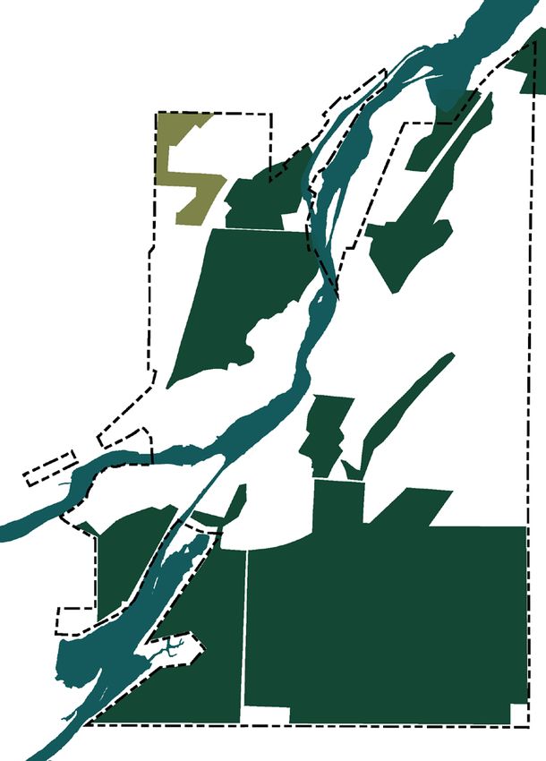
Appendix A: Trent Assessment Parcels (TAP) Summary Sheets                                                                                          1A

   Indigenous Traditional Knowledge
   No sites or areas were specifically identified within TAP 1A through ITK engagement sessions. An area of potential significance was
   identified in close proximity to the TAP. Eastern red cedar, Sweetgrass, Riverbank Grape, Woodland Strawberry, Climbing Bittersweet, Wild
   Tobacco, Ground-cherry, Great Mullein, Plantain species, Pussytoes species, and Ash and Oak tree species were identified as occurring in
   the parcel and were identified in TK for medicinal, sacred and / or resource purposes. The Otonabee River provides habitat for fish, turtles
   and geese; these species groups have sacred and/or resource uses in TK teachings and practices.

   An area of potential significance to Indigenous Peoples was identified through knowledge sharing workshops and walks in close proximity
   to, but not located on, the TAP

      Valued Traditional                    Twelve (12) species / species groups were identified as occurring on the parcel through ITK
      Knowledge Species:                    workshops or sharing meetings (ITK section above). Additional species, identified on other
                                            parcels or through dialogue and knowledge sharing as having TK significance were observed
                                            as occurring on the parcel through the field survey program. The complete list of species with
                                            TK significance is provided below:

                                              White Spruce     Eastern White    Eastern White       Riverbank        Wild Strawberry
                                                                   Pine             Cedar             Grape

                                               White Elm          Bur Oak         Climbing          Staghorn         Ground-cherry
                                                                                 Bittersweet         Sumac              species

                                               White Ash          Common          Yarrow          Aster Species       White-tailed
                                                                  Plantain     Species (Wolly,    (Heart-leaved,         deer
                                                                                 Common)           White Heath,
                                                                                                   Calico, New
                                                                                                   England, Old
                                                                                                 Field, Aster Sp.)

                                                                         Natural Heritage Report                                             A-9
Appendix A: Trent Assessment Parcels (TAP) Summary Sheets                                                                                     1A

       Significant Features & Areas

             Provincially Significant Wetlands        No wetlands occur on 1A. No wetlands are known to occur within 120m of TAP 1A.
             (PSW)

             Significant Wildlife Habitat             Candidate SWH includes:
             (SWH)                                    • Shrub / Early Successional Breeding Bird habitat

                                                      Habitats present are transitioning from cultural meadow to thicket communities.
                                                      Presence of some indicator species in combination with transitional communities
                                                      supports the need for assessment at future planning stages to assess the area as
                                                      SWH.

             Species at Risk (SAR) & Species          Bat acoustic recording captured three vocalizations from a Myotis species and
             of Conservation Concern (SCC)            one vocalizations from Tri-coloured bat; these species are listed as Endangered
                                                      under ESA 2007 (Provincial). Tri-coloured bat and all myotis species (Little Brown
                                                      Myotis, Eastern Small-footed Myotis, Northern Myotis) are federally listed as
                                                      Endangered under SARA 2004. It is anticipated that bat species are using the site
                                                      for foraging; potential suitable habitat for maternity roosting is present across the
                                                      Symons Campus / Trent Lands.

                                                      One Species of Conservation Concern was identified adjacent to the TAP during
                                                      field surveys (associated with SDNA): Eastern Wood-pewee (Special Concern;
                                                      ESA 2007). As the species occurs within 120m of the TAP, it has been included
                                                      in this summary and should be considered through future planning stages, as
                                                      appropriate.

                                                      No other SAR or SCC were observed on the parcel during field surveys or
                                                      identified within the parcel through secondary sources (i.e., social pinpoint,
                                                      iNaturalist, etc.).

             Significant Indigenous                   The Otonabee River is a significant feature and area. It provides habitat for both
             Features & Areas                         resource and sacred species and provides movement corridors for many species.
                                                      In addition to these, water is recognized for its signifance as the earths blood and
                                                      critical to natural systems, plants, animals and people.

   Summary of Constraints

             Summary of Preliminary                   The parcel contains candidate significant features (candidate SWH), which
             Constraints                              require further assessment to confirm or remove preliminary candidacy
                                                      identified here. Habitat present and size indicate that this area requires further
                                                      assessment to confirm constraints level. This area is identified as ‘Pending Further
                                                      Assessment’.

A-10                         Trent Lands and Nature Areas Plan
Appendix A: Trent Assessment Parcels (TAP) Summary Sheets
Assessment Parcel: 1B
General Description
Land Cover and Physiography
The parcel is anthropogenic (cultural) in nature as agricultural practices (either
use as pasture lands or as farmland) was active on this parcel in the past 50-100
years. A CN Rail Line used to bisect the site; the rail line has subsequently been
removed and an unpaved section of the Rotary Greenway Trail follows the former
rail alignment.
Current Land Use(s) & Site Condition
The Rotary Greenway Trail continues through 1B with a pedestrian footbridge
(called the Rotary Greenway Trail Peterborough Bridge). Informal trails occur
throughout as well. There is an active weather station and a compost pile on site.
No research or teaching sites or areas were identified on the TAP.
During 2018 and 2019 surveys Parks Canada construction of a Lock in the
Otonabee River at Nassau Mills Road restricted access to the majority of the
parcel. The construction footprint is approximately 1.7 ha (23%) of the parcel area
and access to the east side was limited.
The overall condition of this site is poor. This site is very cultural (little vegetation
community structure and diversity, high percentage of non-natives, dominant
presence of highly invasive plants) and has many anthropogenic disturbances
Size: ~5 ha (Parks Canada Lock construction, compost site, weather station, site of the old rail
Assessed: 2018-2019 line, formal and informal trails). The recovery of this area to remnant conditions
The southern and eastern will not occur
Location:
boundary for this parcel
is Nassau Mills Road. The
Natural Heritage Surveys Conducted On-Site
western boundary is the
Ecological Land Classification (ELC)
terminus of Armour Road
Three-season flora inventory
and the northern bound- Breeding bird surveys
ary is the Trent-Severn Bat habitat and bat acoustic monitoring
Waterway. 1B is divided Mammal tracking surveys (Winter)
in two portions by the Owl callback surveys
Trent-Severn Waterway/
Otonabee River.
Parcel 1A is located to the
south, on the other side of
Nassau Mills Road
Natural Heritage Report A-11Appendix A: Trent Assessment Parcels (TAP) Summary Sheets 1B
Vegetation & Vegetation Communities
Natural Heritage Description
Total floral species: 130 FQI: 20.38 (low value)
Total non-native plant species: 66 Native mean coefficient: 3.77 (low value)
Notes:
Highly invasive plant species (as regarded by Ontario Invasive Plant Three vegetation communities, defined using Ecological
Council) found on this site include European Buckthorn (Rhamnus Classification for Southern Ontario (Lee et al. 1998) occur in this
cathartica), Garlic Mustard (Alliaria petiolata), European Lily-of-the- parcel:
valley (Convallaria majalis), honeysuckles (Tartarian Honeysuckle • Mineral Cultural Meadow/Cultural Thicket (CUM1/CUT1)
[Lonicera tatarica] and Bell’s Honeysuckle [Lonicera x bella]), and • Mineral Cultural Woodland (CUW1)
Dog-strangling Vine (Vincetoxicum rossicum). • Dry-Fresh White Dear Mixed Forest Ecosite
Each community is generally described below:
1 Mineal Cultural Woodland/ Cultural and early successional species dominate the canopy (10-25m in
Cultural Thicket (CUW1/CUT1) height) and sub-canopy (2-10m in height) of the wooded and thicket areas
(determined by the tree vs shrub coverage; variable coverage across the
site). Cultural meadow and invasive species dominate the understory (1-2m
in height) and ground layer (Appendix A: Trent Assessment Parcels (TAP) Summary Sheets 1B
Vegetation & Vegetation Communities
2 Mineral Cultural Meadow (CUM1)
Common Timothy Orchard Grass Smooth Brome Old-field species dominate the meadow (60% cover) (e.g.,
perennial grasses, heaths, and herbaceous plants). Common Timothy,
Orchard Grass, Smooth Brome, Wild Carrot, Tufted Vetch, Red Clover, Asters
and Goldenrods dominate this community. Common Milkweed (Asclepias
syriaca) and European Buckthorn is succeeding in. At the corner of Armour
Road and Nassau Mills Road is a coniferous hedgerow (Eastern White Cedar
Wild Carrot Tufted Vetch Red Clover
and White Spruce) bordering the meadow. This unit shows displays early
signs of succession.
Common European Aster
Milkweed Buckthorn (Heart-leaved Aster,
Whit Heath Aster,
Calico Aster, New
England Aster, Old
Field Aster)
3 Dry-Fresh White Cedar Mixed
Forest Ecosite (FOM4)
Sugar Maple Eastern White American Sugar Maple and Eastern White Cedar dominate in the canopy (10-25m in
Cedar Basswood height; >60% cover) with American Basswood (Tilia americana), Trembling
Aspen, White Elm (Ulmus americana), and ash associates. The sub-canopy (2-
10m in height; 35-60% cover) is Sugar Maple, ash, White Pine. The understory
(1-2m in height; 10-25% cover) is European Buckthorn. Non-native herbaceous
plants dominate the ground layer (Appendix A: Trent Assessment Parcels (TAP) Summary Sheets 1B
Wildlife
Birds
Number of species: 29
Species Assemblange: Species observed were mostly habitat-generalist and a couple of edge/early
successional species.
Common species:
American Robin Yellow Warbler American Black-capped
Goldfinch Chickadee
Edge/Early Sucesssional
species:
American Northern Cardinal
Redstart
Mammals
Number of Species: 3
Species Assemblange: Species observed were predominantly common spieces found in and near urban and
semi-urban areas
Common species:
Red Fox Deer Mouse White-tailed Deer
Other species: One vegetation community / ecosite (FOM4) on TAP 1B was identified as suitable as potential
bat habitat. Woodland ecosites suitable for supporting bat habitat are present in abundance
within the Trent Lands; the area on TAP 1B represents a relatively small portion of available
habitat and habitat quality is lower than areas available elsewhere The bat species recorded on
the TAP are all determined to be common in Ontario
Big Brown Bat Silver-haired Bat Hoary Bat
A-14 Trent Lands and Nature Areas PlanAppendix A: Trent Assessment Parcels (TAP) Summary Sheets 1B
Wildlife
Insects
Number of Species:
Species Assemblage: Insects were documented incidentally and observations are representative, not comprehensive.
Those species observed are common in Ontario. Low diversity of native vegeation is expected
to reduce overall native insect diversity.
Dragonflies
Common species:
Canadian Tiger Black Saddlebags Widow Skimmer Cherry-faced Red Milkweed
Swallowtail Meadowhawk Beetles
butterfly
Fish
Number of Species: N/A
Species Assemblage: No fish habitat located on the TAP; however the TAP is located in close proximity to the
Otonabee River immediately upstream of Lock 22. The TAP is separated from the river by a
narrow strip of land and Armour Road. The Otonabee River supports habitat for a broad range
of fish.
Common species:
Large and Small Pan Fish Carp Walleye Muskellunge
Mouth Bass
Natural Heritage Report A-15Appendix A: Trent Assessment Parcels (TAP) Summary Sheets 1B
Indigenous Traditional Knowledge
No sites or areas were specifically identified within TAP 1B through ITK engagement sessions. Great Mullein and Pussytoes species were
identified as occurring in the parcel and were identified in TK for medicinal, sacred and / or resource purposes. The Otonabee River
provides habitat for fish, turtles and geese; these species groups have sacred and/or resource uses in TK teachings and practices.
Valued Traditional Great Mullein and Pussytoes species were identified as occurring on the parcel through ITK
Knowledge Species: workshops or sharing meetings. Additional species identified on other parcels or through
dialogue and knowledge sharing as having TK significance were observed as occurring on
the parcel through the field survey program. The complete list of species with TK significance
is provided below:
White Spruce Eastern White Eastern White Riverbank Narrow-leaved
Pine Cedar Grape Cattail
White Elm Paper Birch Climbing Staghorn Ground-cherry
Bittersweet Sumac species
White Ash Common Yarrow Aster Species White-tailed
Plantain Species (Wolly, (Heart-leaved, deer
Common) White Heath,
Calico, New
England, Old
Field, Aster Sp.)
A-16 Trent Lands and Nature Areas PlanAppendix A: Trent Assessment Parcels (TAP) Summary Sheets 1B
Significant Features & Areas
Provincially Significant Wetlands No wetlands occur on 1B. No wetlands are known to occur within 120m of TAP 1B.
(PSW) The Nassau Mills Wetland Complex occurs >250m from this TAP.
Significant Wildlife Habitat Candidate SWH includes:
(SWH) • Bat Maternity Colonies
• Shrub / Early Successional Breeding Bird Habitat
• Special Concern and Rare Wildlife Species
The area of cultural meadow present on TAP1B shows early signs of succession.
Due to its proximity to TAP1A and early evidence of succession, portions of the
TAP are identified as candidate Shrub/Early Successional Breeding Bird Habitat.
Assessment at future planning stages will refine this assessment and determine
whether the site does or does not meet criteria for significance.supports the need
for assessment at future planning stages to assess the area as SWH.
Species at Risk (SAR) & Species Monarch Butterfly, listed as Special Concern under ESA 2007 (Provincial) and
of Conservation Concern (SCC) SARA 2004 (Federal), was observed on the parcel; common milkweed occurs on
the parcel and is the host plant for this species.
Eastern Wood-pewee was observed at the edge of the assessment parcel
(iNaturalist data, 2018, user basilconlin). Eastern Wood-pewee is listed as Special
Concern under ESA 2007 (Provincial) and under SARA 2004 (Federal). No other
SAR or SCC were observed on the parcel during field surveys or identified within
the parcel through secondary sources (i.e., social pinpoint, iNaturalist, etc.).
Significant Indigenous The Otonabee River is a significant feature and area. It provides habitat for both
Features & Areas resource and sacred species and provides movement corridors for many species.
In addition to these, water is recognized for its signifance as the earths blood and
critical to natural systems, plants, animals and people.
Summary of Constraints
Summary of Preliminary As described, 1B is divided in two portions by the Trent-Severn Waterway/
Constraints Otonabee River. There are no confirmed significant features on the TAP. Habitats
present indicate that additional review is appropriate to confirm that SWH is not
present and/or identify appropriate mitigation at the site-specific study level;
however, based on early successional nature of the site and habitat quality they
are identified as ‘low / no constraints’ for this preliminary assessment.
Natural Heritage Report A-17Appendix A: Trent Assessment Parcels (TAP) Summary Sheets 1E
Assessment Parcel: 1E
General Description
Land Cover and Physiography
The parcel is anthropogenic (cultural) in nature as agricultural practices (either
use as pasture lands or as farmland) was active on this parcel in the past 50-100
years. The parcel is gently sloping from west to east, towards the Trent Severn
Waterway with smaller topographical variation occurring on-site.
Current Land Use(s) & Site Condition
No sanctioned recreational land uses on-site. There are no known educational or
research sites or areas on the TAP.
The overall condition of this site is poor. 1E has a recent agricultural history,
contains a high percentage of non-natives, including many highly invasive species
throughout. Encroachment from the residential lots occur along the western
boundary of the TAP. It is unlikely that recovery to the original conditions will
occur.
Natural Heritage Surveys Conducted On-Site
Ecological Land Classification (ELC)
Three-season flora inventory
Breeding bird surveys
Size: ~2 ha
Assessed: 2018-2019
Located along Water Street
Location:
(eastern boundary), the
north and south boundary
is the commercial (Tim
Hortons to the north
and south is the Akash
Superstore / gas bar).
The western limit is
residents along Champlain
Drive. Directly across
Water Street is a power
substation and the Trent-
Severn Waterway and
constructed pond.
A-18 Trent Lands and Nature Areas PlanAppendix A: Trent Assessment Parcels (TAP) Summary Sheets 1E
Vegetation & Vegetation Communities
Natural Heritage Description
Total floral species: 66 FQI: 19.03 (low value)
Total non-native plant species: 28 Native mean coefficient: 3.31 (low value)
Notes:
Highly invasive plant species (as regarded by Ontario Invasive Plant One vegetation communities, defined using Ecological
Council) found on this site include European Buckthorn (Rhamnus Classification for Southern Ontario (Lee et al. 1998) occur in this
cathartica), Dog-Strangling Vine (Vincetoxicum rossicum), Purple parcel:
Loosestrife (Lythrum salicaria), and honeysuckles (Tartarian • Sumac Cultural Thicket Type (CUT1-1)
Honeysuckle [Lonicera tatarica] and Maack’s Honeysuckle
[Lonicera maackii]). The community is generally described below:
1 Mineal Cultural Woodland/
Cultural Thicket (CUW1/CUT1)
Amur Maple Norway Maple English Oak
In the emergent layer (10-25m in height; ≤10% cover) of this community is
dead and dying White Ash and White Elm. Several species of horticultural
trees are found on site such as Amur Maple (Acer tataricum subsp. ginnala),
Norway Maple (Acer platanoides), English Oak (Quercus robur), and Austrian
Pine (Pinus nigra). The canopy (2-10m in height; ≥60% cover) is Staghorn
Austrian Pine Staghorn Cumac European Sumac, European Buckthorn, and Common Apple. The sub-canopy (1-2m
Buckthorn in height; 10-25% cover) is European Buckthorn, Staghorn Sumac, and
Riverbank Grape. The understory (0.5-1m in height; 35-50% cover) is Tall
Goldenrod (Solidago altissima), Canada Goldenrod, Calico Aster, New
England Aster, Old Field Aster, and Arrow-leaved Aster (Symphyotrichum
urophyllum). Ground layer (Appendix A: Trent Assessment Parcels (TAP) Summary Sheets 1E
Wildlife
Birds
Number of species: 17
Species Assemblange: Species observed were often seen leaving the parcel to utilize habitat across Water
Street..
Common species:
American Robin Yellow Warbler Eastern Kingbird Red-winged
Blackbird
Mammals
Number of Species: 1
Species Assemblange: A groundhog burrow was seen onsite during spring surveys. Other urban adapted
species, such as Eastern Gray Squirrel, are likely to be utilizing the site.
Common species:
Groundhog Eastern Gray
Squirrel
Herptile
Number of Species: 1
Species Assemblange: During fall surveys a Northern Leopard Frog was observed on site. Northern Leopard
Frogs transverse large distances after breeding in search of foraging grounds (old
fields and meadows). It is possible the frog travelled from University Heights Park.
Common species:
Northern Leopard
Frog
A-20 Trent Lands and Nature Areas PlanAppendix A: Trent Assessment Parcels (TAP) Summary Sheets 1E
Wildlife
Fish
Number of Species: N/A
Species Assemblage: There is no direct or indirect fish habitat on the TAP. The TAP is separated from the Trent
Severn Waterway by Water Street and intervening land uses. Drainage appears to be internal
to the site and/or to be collected through on-road stormwater catchments. A stormwater pond
located adjacent to the power substation may receive stormwater runoff from Water Street and
ultimately outlet to the River.
Indigenous Traditional Knowledge
No sites, areas or species were specifically identified within TAP 1E through ITK engagement sessions.
Valued Traditional Although no species were specifically identified through ITK workshops and walks on TAP
Knowledge Species: 1E, species identified on other parcels or through dialogue and knowledge sharing as having
TK significance were observed as occurring on the parcel through the field survey program,
including:
White Oak Riverbank Staghorn Eastern Red Wild Strawberry
Grape Sumac Cedar
White Elm Yarrow White Ash Aster Species
Species (Wolly, (Heart-leaved,
Common) White Heath,
Calico, New
England, Old
Field, Aster Sp.)
Natural Heritage Report A-21Appendix A: Trent Assessment Parcels (TAP) Summary Sheets 1E
Significant Features & Areas
Provincially Significant Wetlands No PSW occur on or within 120 m of TAP 1E. An unevaluated wetland is mapped
(PSW) south of the parcel, across Water Street, between the Trent Severn Waterway and
the power substation / stormwater pond.
Significant Wildlife Habitat No Candidate SWH identified.
(SWH)
Species at Risk (SAR) & Species No SAR (Endangered or Threatened species) were observed on TAP 1E.
of Conservation Concern (SCC)
No Species of Conservation Concern were identified on TAP 1E.
No other SAR or SCC were observed on the parcel during field surveys or
identified within the parcel through secondary sources (i.e., social pinpoint,
iNaturalist, etc.).
Significant Indigenous No features or areas were identified on the parcel through ITK workshops or
Features & Areas sharing meetings.
Summary of Constraints
Summary of Preliminary The parcel does not contain any candidate or confirmed significant features and
Constraints therefore has no known constraints based on policy.
A-22 Trent Lands and Nature Areas PlanAppendix A: Trent Assessment Parcels (TAP) Summary Sheets
Assessment Parcel: 1F
General Description
Land Cover and Physiography
The parcel is anthropogenic (cultural) in nature as agricultural practices (either
use as pasture lands or as farmland) was active on this parcel in the past 50-100
years. The houses along Armour road were built between 1929 and 1964. A
drumlin is located to the east of the TAP; the drumlin is generally north-south
oriented with the base of the westerly-northwesterly slope approximately
coincident with the limit of TAP 1E and sloping to the east towards the Otonabee
River. The limit of the drumlin landform generally defines the shoreline of the
Otonabee in this area.
Current Land Use(s) & Site Condition
No sanctioned recreational land uses occur on site. No known educational or
research sites or areas occur on site.
The overall condition of this site is poor. 1F has a recent agricultural history, a
very high percentage of non-natives including many highly invasive species
throughout. The adjacent TAP 1A is also in poor condition. It is unlikely that
recovery to the original conditions will occur.
Natural Heritage Surveys Conducted On-Site
Size: ~0.5 ha Ecological Land Classification (ELC)
Assessed: 2018-2019 Three-season flora inventory
Breeding bird surveys
This small parcel is located
Location: Mammal tracking surveys (Winter)
between Armour Road Owl callback surveys
(western boundary) and
the Rotary Greenway
Trail (Eastern Boundary).
The north boundary is a
cultural meadow/thicket
that extends onto TAP
1A; the south boundary is
1334 Armour Road. Directly
across Armour Road is the
Trent-Severn Waterway.
Natural Heritage Report A-23Appendix A: Trent Assessment Parcels (TAP) Summary Sheets 1F
Vegetation & Vegetation Communities
Natural Heritage Description
Total floral species: 35 FQI: 9.87(low value)
Total non-native plant species: 16 Native mean coefficient: 2.47(low value)
Notes:
No provincially or federally ranked, or at-risk flora species Two vegetation communities, defined using Ecological
occur at this site. Highly invasive plant species (as regarded Classification for Southern Ontario (Lee et al. 1998) occur in this
by Ontario Invasive Plant Council) found on this site include parcel:
European Buckthorn (Rhamnus cathartica), Dog-Strangling Vine • Mineral Cultural Meadow (CUM)
(Vincetoxicum rossicum), and Tartarian Honeysuckle (Lonicera • Hedgerow (HEDGE)
tatarica).
Each community is generally described below:
1 Mineral Cultural Meadow (CUM)
Common Timothy Orchard Grass Smooth Brome
The Cultural Meadow contains less than 25% woody (tree and shrub) cover.
Old-field species dominate the meadow (60% cover) (e.g.,
Wild Carrot Tufted Vetch Red Clover
perennial grasses, heaths, and herbaceous plants). Common Timothy,
Orchard Grass, Smooth Brome, Wild Carrot, Tufted Vetch, Red Clover, Asters
and Goldenrods dominate this community. A few plants of Easter Red Cedar
(Juniperus virginiana) and Common Lilac occurs, and European Buckthorn
is succeeding in. Contiguous to TAP 1A, this area shows evidence of
Common Lilac Eastern Red Tall Golderod successional towards a shrub / thicket community.
Cedar
European Aster
Buckthorn (Heart-leaved Aster,
Whit Heath Aster,
Calico Aster, New
England Aster, Old
Field Aster)
A-24 Trent Lands and Nature Areas PlanAppendix A: Trent Assessment Parcels (TAP) Summary Sheets 1F
Vegetation & Vegetation Communities
2 Hedgerow (HEDGE)
This hedgerow community appears to be from species planted to
intentionally create a barrier; Scots Pine, White Pine, and White Spruce. As
this area is not maintained or apart of a manicured feature, other species
have succeeded in, and the tree species have spread. Old-field species (e.g.,
perennial grasses, heaths, and herbaceous plants) dominate the understory
Scots Pine White Pine White Spruce and ground layer.
Wildlife
Birds
Number of species: 11
Species Assemblange: Species observed were habitat-generalists, capable of nesting in a wide variety of large
and small forests, wetlands and cultural communities in southern Ontario.
Common species:
House Wren American Chipping Sparrow Black-capped Juvenile
Goldfinch Chickadee American
Redstarts
Mammals
Number of Species: 1
Species Assemblange: Deer Mouse was documented during Winter Mammal Tracking Surveys and Cherry-
faced
Common species:
Deer Mouse
Natural Heritage Report A-25Appendix A: Trent Assessment Parcels (TAP) Summary Sheets 1F
Wildlife
Insects
Number of Species: 1
Species Assemblage: Meadowhawks were noted during summer flora surveys.
Common species:
Cherry-faced
Meadowhawk
Fish
Number of Species: N/A
There is no fish habitat located on the TAP; however, the TAP is located in close proximity to
Species Assemblage:
the Otonabee River. The TAP is separated from the river by a narrow strip of land and Armour
Road. The Otonabee River supports habitat for a broad range of fish including large and small
mouth bass, pan fish, carp, walleye, and muskellunge.
A-26 Trent Lands and Nature Areas PlanAppendix A: Trent Assessment Parcels (TAP) Summary Sheets 1F
Indigenous Traditional Knowledge
No sites, areas or species were specifically identified within TAP 1F through ITK engagement sessions.
Valued Traditional Although no species were specifically identified through ITK workshops and walks on TAP
Knowledge Species: 1F, species identified on other parcels or through dialogue and knowledge sharing as having
TK significance were observed as occurring on the parcel through the field survey program,
including:
White Spruce Riverbank Staghorn Eastern Red Eastern White
Grape Sumac Cedar Pine
Ground-cherry Yarrow Aster Species Climbing
species Species (Wolly, (Heart-leaved, Bittersweet
Common) White Heath,
Calico, New
England, Old
Field, Aster Sp.)
Natural Heritage Report A-27Appendix A: Trent Assessment Parcels (TAP) Summary Sheets 1F
Significant Features & Areas
Provincially Significant Wetlands No wetlands occur on 1F. No wetlands occur within 120m of TAP 1F east of the
(PSW) Otonabee River; A small wetland is identified through secondary source mapping
within 120m on the west side of the Otonabee River.
Significant Wildlife Habitat Candidate SWH includes:
(SWH) • Shrub / Early Successional Breeding Bird Habitat
TAP 1F is contiguous to TAP 1A. The cultural meadow community shows evidence
of early succession indicating that site-specific consideration for the contiguous
areas of habitat (TAP 1A, 1F and beyond) is warranted. Determination of habitat
significance (i.e. significant or not significant) will be made through site-specific
study.
Species at Risk (SAR) & Species No SAR (Endangered or Threatened Species) were identified on the TAP.
of Conservation Concern (SCC)
No SCC species were identified on the TAP.
No other SAR or SCC were observed on the parcel during field surveys or
identified within the parcel through secondary sources (i.e., social pinpoint,
iNaturalist, etc.).
Significant Indigenous The Otonabee River is a significant feature and area. It provides habitat for both
Features & Areas resource and sacred species and provides movement corridors for many species.
In addition to these, water is recognized for its significance as the earths blood
and critical to natural systems, plants, animals and people.
Summary of Constraints
Summary of Preliminary The parcel contains candidate significant features (candidate SWH), which
Constraints require further assessment to confirm the significance designation. As this area is
contiguous to and shows similar characteristics to TAP 1A, TAP 1F is identified as
‘Pending Further Assessment’ through preliminary assessment. Determination of
habitat significance (i.e. significant or not significant) will be made through site-
specific study.
A-28 Trent Lands and Nature Areas PlanAppendix A: Trent Assessment Parcels (TAP) Summary Sheets
Assessment Parcel: 2C
General Description
Land Cover and Physiography
The parcel is anthropogenic (cultural) in nature. The parcel was used for active
agricultural (either use as pasture lands or as farmland) in the past 50 years. TAP
2C is has low topographic relief, gently sloping to the east.
Current Land Use(s) & Site Condition
No formal recreational or educational land uses occur on-site. No research or
educational sites or areas were identified as occurring on the TAP. The land has
been left fallow and is slowly regenerating.
The overall condition of this site is poor-fair. This site is very cultural (little
vegetation community structure and diversity, high percentage of non-natives),
has a recent history of anthropogenic disturbances (agriculture), as well as
motorized vehicle use and informal trails. The recovery of this area to remnant
conditions will not occur.
Natural Heritage Surveys Conducted On-Site
Ecological Land Classification (ELC)
Three-season flora inventory
Breeding bird surveys
Size: ~3 ha
Western Chorus Frog and calling Anuran surveys
Assessed: 2018-2019 Bat habitat and bat acoustic monitoring
TAP 2C fronts onto Wood- Mammal tracking surveys (Winter)
Location: Owl callback surveys
land Drive to the south and
is bounded by the Total
Loss Farm Nature Area
(TLFNA) to the north and
east. A watercourse flows
through the TLFNA to the
north of TAP 2C and sepa-
rates TAP 2C and 2D.
Natural Heritage Report A-29Appendix A: Trent Assessment Parcels (TAP) Summary Sheets 2C
Vegetation & Vegetation Communities
Natural Heritage Description
Total floral species: 93 FQI: 24.05 (low value)
Total non-native plant species: 28 Native mean coefficient: 3.11 (low value)
Notes:
No provincially or federally ranked, or at-risk flora species occur Three vegetation communities, defined using Ecological
at this site. Highly invasive plant species (as regarded by Ontario Classification for Southern Ontario (Lee et al. 1998) occur in this
Invasive Plant Council) found on this site include European parcel:
Buckthorn (Rhamnus cathartica) and Tartarian Honeysuckle • Mineral Cultural Savannah (CUS1)
(Lonicera tatarica). • Mineral Cultural Woodland (CUW1)
• Dry-Fresh Poplar Mixed Forest Type (FOM5-2)
Each community is generally described below:
1 Mineral Cultural Savannah (CUS1)
Scots Pine White Elm White Ash
The CUS occurs in the central portion of of 2C and boarders the narrow strip
of meadow marsh that divdies 2C from 2D. The canopy (2-10m in height;
25-35% cover) in the cultural savannah is Green and White Ash, White Elm
and Scots Pine. The sub-canopy (1-2m in height; 25-35% cover) is ash and
Scots Pine. The understory (0.5-1m in height; 25-35% cover) is Scots Pine
Common Juniper Poison Ivy Tall Golderod and Common Juniper. The ground layer (≤1m in height; >60% cover) is
old-field species (e.g., perennial grasses, heaths, and herbaceous plants);
Common Timothy, Orchard Grass, Smooth Brome, Wild Carrot, Tufted Vetch,
Red Clover, Aster species (New England Aster, Old Field Aster, etc.) and
Goldenrod species (Solidago sp.). Poison Ivy is universal in the ground layer.
Common Timothy Orchard Grass Smooth Brome
Wild Carrot Tufted Vetch Red Clover
A-30 Trent Lands and Nature Areas PlanAppendix A: Trent Assessment Parcels (TAP) Summary Sheets 2C
Vegetation & Vegetation Communities
1 Mineral Cultural Savannah (CUS1)
Willow Species Marsh Marigold Silky Dogwood Between 2D and 2C is a meadow marsh supported by the watercourse
that occurs. The area supports a variety of species; Bebb’s Willow (Salix
bebbiana) , Pussy Willow (Salix discolor), Cottony Willow (Salix eriocephala),
Marsh Marigold (Caltha palustris), Silky Dogwood (Cornus obliqua), Boneset
(Eupatorium perfoliatum), Spotted Joe Pye Weed (Eutrochium maculatum),
Rice Cutgrass (Leersia oryzoides), Reed Canarygrass (Phalaris arundinacea),
Boneset Spotted Joe Pye Rice Cutgrass
Weed and several other wetland species.
Offsite, along Lakefield Road, is the remains of a hedgerow that boarders the
boundary of 2C. The canopy (10-25m in height; >60% cover) is Sugar Maple
(Acer saccharum), American Basswood (Tilia americana), and ash. The
sub-canopy is depapurate while the understory (1-2 m in height; >60% cover)
Reed Canarygrass American Sugar Maple
Basswood is European Buckthorn. The ground layer (60% cover) is Zig-
zag Goldenrod (Solidago flexicaulis) in the upland and the meadow marsh
community in the bottomland.
European Tall Golderod Aster
Buckthorn (Heart-leaved Aster,
Whit Heath Aster,
Calico Aster, New
England Aster, Old
Field Aster)
Natural Heritage Report A-31Appendix A: Trent Assessment Parcels (TAP) Summary Sheets 2C
Vegetation & Vegetation Communities
2 Mineral Cultural Woodland (CUW1)
An inclusion of Mineral Cultural Woodland (CUW1) occurs within the
White Spruce White Elm Scots Pine
CUS1 community. The inclusion has a typical vegetation composition of
agriculturally influenced areas. The cultural woodland canopy (2-10m in
height; 35-60% cover) is a mix of White Spruce (Picea glauca), White Elm
(Ulmus americana), Scots Pine (Pinus sylvestris), and dead/dying ash
(Fraxinus species).
European Paper Birch Common Juniper The sub-canopy (1-2m in height; 35-60% cover) is European Buckthorn
Buckthorn
(Rhamnus cathartica), ash, and occasional Paper Birch (Betula papyrifera).
The undertsory (0.5-1m in height) is European Buckthorn, Common Juniper
(Juniperus communis), Eastern White Cedar (Thuja occidentalis), and Scots
Pine seedlings.
Common Timothy Orchard Grass Smooth Brome The ground layer (≤0.5m in height; >60% cover) is old-field species (e.g.,
perennial grasses, heaths, and herbaceous plants); Common Timothy (Phleum
pratense), Orchard Grass (Dactylis glomerata), Smooth Brome (Bromus
inermis), Wild Carrot (Daucus carota), Tufted Vetch (Vicia cracca), Red Clover
(Trifolium pratense), Aster species (New England Aster [Symphyotrichum
novae-angliae], Old Field Aster [Symphyotrichum pilosum], etc.) and Tall
Wild Carrot Tufted Vetch Red Clover
Goldenrod (Solidago altissima). Poison Ivy (Toxicodendron racicans var.
rydbergii) is ubiquitous in the ground layer.
Eastern White Tall Golderod Poison Ivy
Cedar
A-32 Trent Lands and Nature Areas PlanAppendix A: Trent Assessment Parcels (TAP) Summary Sheets 2C
Vegetation & Vegetation Communities
3 Dry-Fresh Poplar Mixed Forest
Type (FOM5-2)
This community occurs along to Woodland Drive and extends up Water
Eastern White Trembling Aspen White Spruce Street. A small section occurs within the parcel; outside of the parcel some
Cedar
areas or Eastern White Cedar are very dense and little diversity or structure
occurs. Within the parcel Eastern White Cedar, Trembling Aspen, and White
Spruce dominate in the canopy (10-25m in height; 35-60% cover) with White
Elm (Ulmus americana), Green Ash, White Ash, and Paper Birch associates.
The sub-canopy (2-10m in height; 35-60% cover) contains the same species.
White Ash Paper Birch European The understory (1-2m in height; 10-25% cover) is dominated by European
Buckthorn
Buckthorn and some succession of canopy species. The ground layer (Appendix A: Trent Assessment Parcels (TAP) Summary Sheets 2C
Wildlife
Birds
Number of species: 24
Species Assemblange: Species observed were a mix of habitat-generalist, edge/early successional, and forest
species. Generalist species capable of nesting in a wide variety of large and small forests,
wetlands and cultural communities in southern Ontario
Common species:
Song Sparrow House Wren American Chipping Sparrow Black-capped
Goldfinch Chickadee
American American Robin Baltimore Oriole Brown-headed Chipping Sparrow
Goldfinch Cowbird
Edge/Early Successional
species:
American Nashville Warbler Northern Cardinal
Woodcock
Area sensitive species:
Alder Flycatcher Cooper’s Hawk Great Crested
Flycatcher
A-34 Trent Lands and Nature Areas PlanAppendix A: Trent Assessment Parcels (TAP) Summary Sheets 2C
Wildlife
Mammals
Number of Species: 2
Species Assemblange: Species observed were predominantly common spieces found in and near urban and
semi-urban areas. It is highly probable that other species, such as mice and raccoons,
are found on this parcel.
Common species: Possible coyote tracks were
observed. Imperfect tracks
and high volume of domestic
dog prints prevent definitive
White-tailed Deer Red Fox Coyote confirmation.
Other species: One vegetation community / ecosite (FOM5-2) on TAP 2C was identified as suitable as
potential bat habitat. There was one record of a myotis species. All myotis species that occur in
Ontario are listed as Endangered.
Big Brown Bat Silver-haired Bat Eastern Red Bat Hoary Bat Tri-coloured Bat
Herptile
Number of Species: N/A
Species Assemblange: Anuran calling station #1 (also Western Chorus Frog Station #11) is located at the
north end of TAP 2C and faces into the meadow marsh wetland and watercourse
located within the Total Loss Farm Nature Area. No calling amphibians (anurans) were
recorded during any of the surveys.
Natural Heritage Report A-35Appendix A: Trent Assessment Parcels (TAP) Summary Sheets 2C
Wildlife
Insects
Number of Species: 4
Species Assemblage: Insects were documented incidentally and observations are representative, not comprehensive.
Those species observed are common in Ontario. Low diversity of native vegetation is expected
to reduce overall native insect diversity.
Common species:
Hickory Tussock Woolly Bear Cherry-faced Winter Firefly
Moth Meadowhawk
Fish
Number of Species: N/A
Species Assemblage: No watercourses or fish habitat occur on TAP 2C; an unnamed watercourse originates in the
forested wetland north of the parcel within the Total Loss Farm Nature Area (TLFNA) and flows
as an intermittent stream as it crosses into privately own agricultural lands east of 2D. The
watercourse becomes permanent as it flows through the property to the east before turning
abruptly west and flowing between parcels 2D and 2C within the TLFNA. The watercourse
crosses under Lakefield Road and flows east through Lock 22 Nature Area south of TAP 2E,
through a stormwater management pond and finally outletting to the Trent-Severn Waterway
at Lock 22 (L22A). Water was present through the section that flows in the TLFNA between
TAP 2C and 2D at the time of field investigations (spring, summer), confirming that the
watercourse is permanent through this reach.
A-36 Trent Lands and Nature Areas PlanAppendix A: Trent Assessment Parcels (TAP) Summary Sheets 2C
Indigenous Traditional Knowledge
No sites or areas were specifically identified within TAP 2C through ITK engagement sessions. Wild Ginger, Plantain sp., and Mullein were
identified as occurring on the parcel and have medicinal, sacred and/or resource significance in TK.
Valued Traditional Wild Ginger, Plantain sp., and Mullein were identified as occurring on the parcel through ITK
Knowledge Species: workshops or sharing meetings. Additional species identified on other parcels or through
dialogue and knowledge sharing as having TK significance were observed as occurring on
the parcel through the field survey program. The complete list of species with TK significance
is provided below
White Spruce Eastern White Eastern White Riverbank Wild Strawberry
Pine Cedar Grape
White Elm Paper Birch White Ash Staghorn Yarrow
Sumac Species (Wolly,
Common)
Aster Species
(Heart-leaved,
White Heath,
Calico, New
England, Old
Field, Aster Sp.)
Natural Heritage Report A-37Appendix A: Trent Assessment Parcels (TAP) Summary Sheets 2C
Significant Features & Areas
Provincially Significant Wetlands No PSW occur on or within 120m of TAP 2C. Wetlands (meadow marsh) adjacent
(PSW) to the parcel are ‘unevaluated’ for provincial significance.
Significant Wildlife Habitat No candidate SWH identified:
(SWH)
TAP 2C and 2D, when considered together, meet habitat requirements for Raptor
Wintering (Feeding and Roosting) Areas. Based on available observational data
the species requirements are not met and as such it was determined that this
SWH type was not present. Additional survey through site-specific work (e.g.,
and EIS) should consider this habitat type at the time of site-specific planning to
confirm this assessment.
Species at Risk (SAR) & Species Monarch Butterfly, listed as Special Concern under ESA 2007 (Provincial) and
of Conservation Concern (SCC) SARA 2004 (Federal), was observed on the parcel; common milkweed occurs on
the parcel and is the host plant for this species.
Bat acoustic recording captured one vocalization from a Myotis species and
one vocalization from Tri-coloured bat; these species are listed as Endangered
under ESA 2007 (Provincial). Tri-coloured bat and all myotis species (Little
Brown Myotis, Eastern Small-footed Myotis, Northern Myotis) are federally listed
as Endangered under SARA 2004. It is anticipated that bat species are primarily
using the site for foraging (which is not considered Significant Wildlife Habitat)
and have potential to use the FOM5-2 vegetation community / ecosite for
roosting. While the majority of this vegetation community occurs adjacent to the
parcel (associated with TLFNA), a portion of the community extends onto TAP
2C.
No other SAR or SCC were observed on the parcel during field surveys or
identified within the parcel through secondary sources (i.e., social pinpoint,
iNaturalist, etc.).
Significant Indigenous No features or areas were identified on the parcel through ITK workshops or
Features & Areas sharing meetings.
Summary of Constraints
Summary of Preliminary The parcel does not contain any candidate or confirmed significant features and
Constraints therefore has no known constraints based on policy. This area is identified as ‘No
Known Constraints’ in the preliminary assessment.
A-38 Trent Lands and Nature Areas PlanAppendix A: Trent Assessment Parcels (TAP) Summary Sheets
Assessment Parcel: 2D
General Description
Land Cover and Physiography
The parcel is anthropogenic (cultural) in nature. The parcel was used for active
agricultural (either use as pasture lands or as farmland) in the past 50 years.
Coniferous plantations are established on-site; based on aerial imagery, it is
anticipated these were planted in the 1970s.
Current Land Use(s) & Site Condition
No formal recreational or educational land uses occur on-site.
No land uses such as recreation, educational or research sites were identified as
occurring on the Trent Assessment Parcel (TAP) through consultation processes
or secondary source information. An informal trail loop was observed onsite;
it appears to be maintained purposefully or through frequency of use by local
members of the community.
The overall condition of this site is poor-fair. Vegetation communities present
have a high percentage of non-native species, and highly invasive plant species
are prevalent throughout.
Natural Heritage Surveys Conducted On-Site
Ecological Land Classification (ELC)
Size: ~14 ha Three-season flora inventory
Breeding bird surveys
Assessed: 2018-2019 Western Chorus Frog and calling Anuran surveys
Located along Lakefield Bat habitat and bat acoustic monitoring
Location: Mammal tracking surveys (Winter)
Road (eastern boundary),
Owl callback surveys
the northeast corner is
bounded by the Selwyn
Township divide. To the
west and south is an inter-
mittent watercourse. Parcel
2C is located south, on the
other side of the water-
course, and 2E is located
on the opposite side of
Lakefield Road.
Natural Heritage Report A-39Appendix A: Trent Assessment Parcels (TAP) Summary Sheets 2D
Vegetation & Vegetation Communities
Natural Heritage Description
Total floral species: 121 FQI: 26.91 (low value)
Total non-native plant species: 46 Native mean coefficient: 3.31 (low value)
Notes:
No provincially or federally ranked, or at-risk flora species occur Eight vegetation communities, defined using Ecological
at this site. Highly invasive plant species (as regarded by Ontario Classification for Southern Ontario (Lee et al. 1998) occur in this
Invasive Plant Council) found on this site include Dog-Strangling parcel:
Vine (Vincetoxicum rossicum), European Buckthorn (Rhamnus • Mineral Cultural Woodland (CUW1)
cathartica), honeysuckles (Tartarian Honeysuckle [Lonicera • Deciduous Hedgerow (HEDGE)
tatarica] and Morrow’s Honeysuckle [Lonicera morrowii]), and • Coniferous Plantation (CUP3) and White Spruce – European
Periwinkle (Vinca minor). Larch Coniferous Plantation Type (CUP3-8)
• Mineral Cultural Meadow (CUM1)
• Thicket Swamp (SWT)
• Mineral Cultural Savannah (CUS1)
• Fresh – Moist White Cedar Coniferous Forest Ecosite (FOC4)
Each community is generally described below:
1 Mineral Cultural Woodland (CUW1)
Cultural woodland occurs in the south of 2D. The cultural woodland has a
very typical vegetation composition of agriculturally influenced areas. The
canopy (10-25 m in height; 35-60% cover) varies. In the northwest, the
woodland canopy is Red Pine, Scots Pine, and White Ash. In the southeast,
Scots Pine Trembling Aspen White Ash the canopy is Black Locust and Trembling Aspen. The sub-canopy (2-10m
in height; 10-25% cover) is comprised of the same species that occur in the
canopy as well as White Elm. The understory and ground story (60% cover) is European Buckthorn, Common Juniper (Juniperus
communis), Eastern White Cedar, and Scots Pine seedlings with old-field
European Common Juniper species (e.g., perennial grasses, heaths, and herbaceous plants); Common
White Elm
Buckthorn Timothy (Phleum pratense), Orchard Grass (Dactylis glomerata), Smooth
Brome (Bromus inermis), Wild Carrot (Daucus carota), Tufted Vetch (Vicia
cracca), Red Clover (Trifolium pratense), Aster species (New England Aster,
Old Field Aster, etc.) and Tall Goldenrod (Solidago altissima). Poison ivy is
ubiquitous in the ground layer.
Eastern White Common Timothy Orchard Grass
Cedar Between 2D and 2C is a meadow marsh supported by the watercourse.
The area supports a variety of species; Bebb’s Willow (Salix bebbiana),
Pussy Willow (Salix discolor), Cottony Willow (Salix eriocephala), Marsh
Marigold (Caltha palustris), Silky Dogwood (Cornus obliqua), Boneset
Smooth Brome Wild Carrot Tufted Vetch
A-40 Trent Lands and Nature Areas PlanYou can also read