Places for Everyone JPA3.2 Timperley Wedge Allocation Topic Paper July 2021 - Greater Manchester Combined Authority
←
→
Page content transcription
If your browser does not render page correctly, please read the page content below
Places for Everyone JPA3.2 Timperley Wedge Allocation Topic Paper July 2021
Contents Page

 Section A – Background ......................................................................................................4
     1.0      Introduction ...........................................................................................................4
     2.0      Timperley Wedge Overview ..................................................................................6
     3.0      Site Details ............................................................................................................7
     4.0      Proposed Development .........................................................................................9
     5.0      Site Selection ...................................................................................................... 11
     6.0      Planning History .................................................................................................. 12
     7.0      GMSF 2019 Consultation Responses ................................................................. 14
     8.0      GMSF 2019 Integrated Assessment ................................................................... 15
     9.0      GMSF 2020 Integrated Assessment ................................................................... 17
 Section B – Physical .......................................................................................................... 19
     10.0 Transport ............................................................................................................. 19
     11.0 Flood Risk and Drainage ..................................................................................... 23
     12.0 Ground Conditions .............................................................................................. 25
     13.0 Utilities................................................................................................................. 25
     14.0 Other Constraints ................................................................................................ 25
 Section C – Environmental ................................................................................................ 26
     15.0 Green Belt Assessment....................................................................................... 27
     16.0 Green Infrastructure ............................................................................................ 37
     17.0 Recreation ........................................................................................................... 38
     18.0 Landscape........................................................................................................... 39
     19.0 Ecological/Biodiversity Assessment .................................................................... 40
     20.0 Habitat Regulation Assessment .......................................................................... 41
     21.0 Heritage Impact Assessment .............................................................................. 42
     22.0 Air Quality............................................................................................................ 45
     23.0 Noise ................................................................................................................... 45
 Section D – Social ............................................................................................................. 46
     24.0 Education ............................................................................................................ 46
     25.0 Health .................................................................................................................. 47
 Section E – Deliverability ................................................................................................... 48
     26.0 Viability ................................................................................................................ 48
     27.0 Phasing ............................................................................................................... 48
     28.0 Indicative Masterplanning.................................................................................... 50
 Section F – Conclusion...................................................................................................... 53
     29.0 The Sustainability Appraisal ................................................................................ 53

Timperley Wedge Site Allocation Topic Paper – PfE 2021                                                                            2
30.0 The main changes to the proposed Timperley Wedge Allocation ....................... 53
31.0 Conclusion .......................................................................................................... 54
Section G – Appendices .................................................................................................... 56
Appendix A - Timperley Wedge Policy JPA3.2 from PfE 2021 .......................................... 57
Appendix B - Timperley Wedge Policy GM3.2 from GMSF 2020 ...................................... 70
Appendix C - Timperley Wedge Policy GM46 from GMSF 2019 ....................................... 83
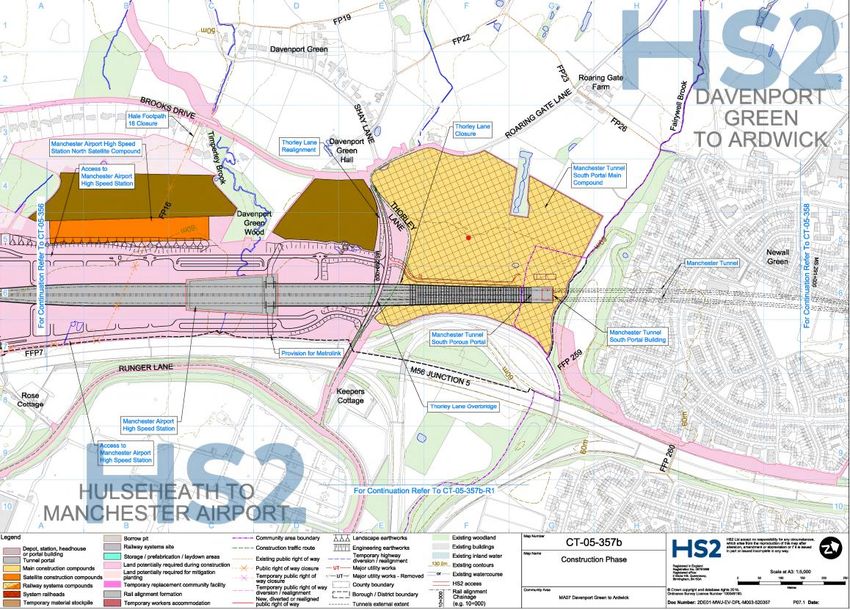
Appendix D - HS2 DRC 2 consultation Manchester Airport High Speed Station – 2020 ... 88
Appendix E - HS2 Consolidated Construction Boundary as at June 2021 ........................ 89
References (added 09/08/2021) ........................................................................................ 90
List of Figures
Figure 1 JPA 3.2 Timperley Wedge Location Plan ................................................................7
Figure 2: Planning applications at Timperley Wedge ........................................................... 14
Figure 3: The indicative vehicle access points from the spine road and the existing and
proposed active routes ........................................................................................................ 22
Figure 4 Line of existing Sewer across Timperley Wedge ................................................... 26
Figure 5 Harm of proposed Green Belt release in GMSF 2019 for Timperley Wedge by land
parcel ................................................................................................................................... 30
Figure 6 Harm of proposed Green Belt release in GMSF 2020 for Timperley Wedge by land
parcel ................................................................................................................................... 31
Figure 7 Green Infrastructure Plan ...................................................................................... 38
Figure 8 Sensitivity of archaeology by HECA ...................................................................... 44
Figure 9 Timperley Wedge Phasing Regions ...................................................................... 49
Figure 10 Indicative Masterplan........................................................................................... 51
List of Tables
Table 1: Mitigation Measures from Locality Assessment ..................................................... 21
Table 2: Cost per pupil by education sector......................................................................... 47
Timperley Wedge Site Allocation Topic Paper – PfE 2021 3
Section A – Background

1.0   Introduction

1.1   In November 2014, the AGMA (Association of Greater Manchester Authorities)
      Executive Board recommended to the 10 Greater Manchester local authorities that
      they agree to prepare a joint Development Plan Document (“Joint DPD”), called the
      Greater Manchester Spatial Framework (“GMSF”) and that AGMA be appointed by
      the 10 authorities to prepare the GMSF on their behalf.

1.2   The first draft of the GMSF DPD was published for consultation on 31st October
      2016, ending on 16th January 2017. Following substantial re-drafting, a further
      consultation on the Revised Draft GMSF took place between January and March
      2019.

1.3   On the 30 October 2020 the AGMA Executive Board unanimously agreed to
      recommend GMSF 2020 to the 10 Greater Manchester Councils for approval for
      consultation at their Executives/Cabinets, and approval for submission to the
      Secretary of State following the period for representations at their Council meetings.

1.4   At its Council meeting on 3 December 2020 Stockport Council resolved not to submit
      the GMSF 2020 following the consultation period and at its Cabinet meeting on 4
      December, it resolved not to publish the GMSF 2020 for consultation.

1.5   As a joint DPD of the 10 Greater Manchester authorities, the GMSF 2020 required
      the approval of all 10 local authorities to proceed. The decisions of Stockport
      Council/Cabinet therefore signalled the end of the GMSF as a joint plan of the 10.

1.6   Notwithstanding the decision of Stockport Council, the nine remaining districts
      considered that the rationale for the preparation of a Joint DPD remained.
      Consequently, at its meeting on the 11th December 2020, Members of the AGMA
      Executive Committee agreed in principle to producing a joint DPD of the nine
      remaining Greater Manchester (GM) districts. Subsequent to this meeting, each
      district formally approved the establishment of a Joint Committee for the preparation
      of a joint Development Plan Document of the nine districts.

1.7   Section 28 of the Planning and Compulsory Purchase Act 2004 and Regulation 32 of
      the Town and Country Planning (Local Planning) (England) Regulations 2012 enable

Timperley Wedge Site Allocation Topic Paper – PfE 2021                                     4
a joint plan to continue to progress in the event of one of the local authorities
      withdrawing, provided that the plan has ‘substantially the same effect’ on the
      remaining authorities as the original joint plan. The joint plan of the nine GM districts
      has been prepared on this basis.

1.8   In view of this, it follows that PfE should be considered as, in effect, the same Plan
      as the GMSF, albeit without one of the districts (Stockport). Therefore “the plan” and
      its proposals are in effect one and the same. Its content has changed over time
      through the iterative process of plan making, but its purpose has not. Consequently,
      the Plan is proceeding directly to Publication stage under Regulation 19 of the Town
      and Country Planning (Local Planning) England Regulations 2012.

1.9   Four consultations took place in relation to the GMSF. The first, in November 2014
      was on the scope of the plan and the initial evidence base, the second in November
      2015, was on the vision, strategy and strategic growth options, and the third, on a
      Draft Plan in October 2016.

1.10 The fourth and most recent consultation on The Greater Manchester Plan for Homes,
      Jobs and the Environment: the Greater Manchester Spatial Framework Revised
      Draft 2019 (GMSF 2019) took place in 2019. It received over 17,000 responses. The
      responses received informed the production of GMSF 2020. The withdrawal of
      Stockport Council in December 2020 prevented GMSF 2020 proceeding to
      Regulation 19 Publication stage and instead work was undertaken to prepare PfE
      2021.

1.11 Where a local planning authority withdraws from a joint plan and that plan continues
      to have substantially the same effect as the original joint plan on the remaining
      authorities, s28(7) of the Planning and Compulsory Purchase Act 2004 provides that
      any step taken in relation to the plan must be treated as a step taken by the
      remaining authorities for the purposes of the joint plan. On this basis, it is proposed
      to proceed directly to Publication stage under Regulation 19 of the Town and
      Country Planning (Local Planning) England Regulations 2012.

1.12 A comprehensive evidence base was assembled to support the policies and
      proposals in the GMSF 2020. Given the basis on which the Plan has been prepared,
      this evidence base remains the fundamental basis for the PfE 2021and has
      remained available on the GMCA’s website since October 2020. That said, this
      evidence base has been reviewed and updated in the light of the change from GMSF

Timperley Wedge Site Allocation Topic Paper – PfE 2021                                      5
2020 to the PfE2021 and, where appropriate, addendum reports have been
      produced and should be read in conjunction with evidence base made available in
      October 2020. The evidence documents which have informed the plan are available
      via the GMCA’s website.

2.0   Timperley Wedge Overview

2.1   The Timperley Wedge strategic allocation in the Places for Everyone Plan 2021 (PfE
      2021) provides an opportunity to deliver a substantial development with a broad mix
      of housing in a distinctive neighbourhood and high quality office space to support the
      expansion of Manchester Airport and University Hospital South Manchester.

2.2   The allocation is situated in Trafford between Timperley and Hale Barns which are
      popular residential areas. The allocation has well-connected transport links to
      surrounding residential areas and is also adjacent to the Manchester Council border
      with Newall Green and the M56 in the south east.

2.3   Timperley Wedge is located adjacent to two other key areas identified for growth in
      PfE 2021: Medipark and Manchester Airport. Both of these areas are located in
      Manchester. Medipark and Timperley Wedge are presented in the PfE 2021 as a
      cross boundary allocation as they are located next to each other and development at
      both allocations with complement each other. However they both have separate
      allocation policies and are likely to be subject to separate planning applications.

2.4   Growth at Medipark and Manchester Airport will provide a significant increase in
      employment floor space in the local area, in combination with new housing and
      additional employment floor space at Timperley Wedge, creating a complementary
      and mixed use community. Timperley Wedge is uniquely located to benefit from and
      support growth in these adjacent areas and provide cohesive transport links and
      green infrastructure connections with Medipark and Manchester Airport.

2.5   Connectivity will also be improved with the delivery of the proposed Metrolink
      Western Leg extension providing new stops through Wythenshawe, Medipark and
      Timperley Wedge, and High Speed 2 (HS2) giving a new link from the existing
      Roundthorn stop on the East Didsbury Line to Manchester Airport. This will give
      better connections south to Manchester Airport but also north to Trafford Park and
      other employment areas.

Timperley Wedge Site Allocation Topic Paper – PfE 2021                                      6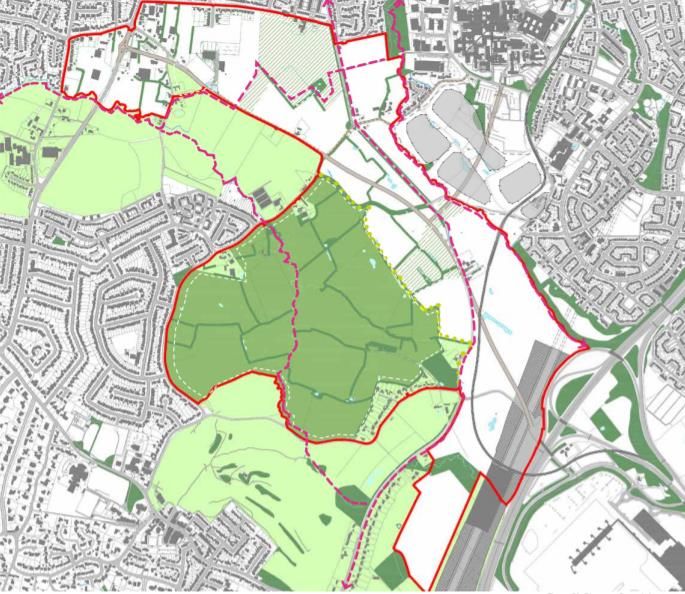
2.6 High Speed 2 (HS2) Phase 2b is proposed to have a station at Manchester Airport.
The station location is adjacent to Timperley Wedge, to the west of the M56. In
February 2020 the government announced its intention to proceed with HS2 Phase
2b any Hybrid Bill deposit for Phase 2b is expected to be early 2022. The HS2
Manchester Airport Station, as well as future proposals for Northern Powerhouse
Rail (NPR) will create a step change in transport connectivity to the area.
3.0 Site Details
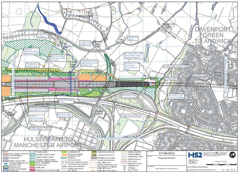
3.1 The total allocation area at Timperley Wedge is 226 ha. It comprises of land west of
Junction 5 on the M56, running north along the boundary with Manchester to the
existing urban area of Timperley. As illustrated in Figure 1 below.
Figure 1 JPA 3.2 Timperley Wedge Location Plan
3.2 The site is predominantly greenfield land with a limited amount of brownfield land.
The land use is predominantly agricultural pasture land but also includes some
airport car parking, garden nursery sites, Hale Country Club and playing fields at
Bowdon Rugby Club and Manor Farm. Altrincham Masonic Hall on Clay Lane
provides community facilities.
3.3 There are existing residential properties within the allocation which are not proposed
for redevelopment, including isolated properties and farms as well as groups of
Timperley Wedge Site Allocation Topic Paper – PfE 2021 7
properties along Shay Lane, Wellfield Lane and part of Ridgeway Road and Wood
Lane. There are some listed buildings along Roaring Gate Lane and non-designated
heritage assets throughout the area.
3.4 The site includes a large Site of Biological Interest (SBI), Davenport Green Ponds
and a smaller SBI which is ancient woodland at Davenport Green Wood. Neither are
proposed for development as part of Places for Everyone 2021 (PfE).
3.5 Within the Trafford Core Strategy 2012 the site is allocated as follows:-
The majority of the site is allocated as Green Belt in Policy R4
The site is within a Wildlife Corridor as identified in Policy R3.
The site includes 20ha of protected open space land at Hale Country Club,
Bowdon Rugby Club and the playing fields at Manor Farm as identified in Policy
R5
At Davenport Green 36 ha of land is not designated as Green Belt and is allocated
for high quality office development in Policy R4.3 and W1.
3.6 New Development at the Timperley Wedge strategic allocation makes an important
contribution to meeting the policies in the PfE 2021 Spatial Strategy, more
specifically strategic policy JP- Strat 9 and policy Strat-10. Policy JP-Strat 9 Southern
Areas is a strategic policy that supports the protection and enhancement of the
economic competitiveness, neighbourhood quality and environmental attractiveness
of the southern areas of Greater Manchester. Policy JP-Strat 10 Manchester Airport
seeks to maximise the benefits to Greater Manchester of the continued operation
and sustainable growth of Manchester Airport and its surrounding locality. Timperley
Wedge is part of Southern Area and Manchester Airport localities in the spatial
strategy.
3.7 A Timperley Wedge Masterplan has been prepared to support the allocation which
sets out development totals and identifies indicative development parcels and
phasing. A range of evidence base documents have been prepared to support the
PfE strategic allocation and to inform the Masterplan. Further masterplanning work
will be required to provide a detailed framework for how the Timperley Wedge site
can come forward and this is a requirement of Policy JPA3.2.
Timperley Wedge Site Allocation Topic Paper – PfE 2021 8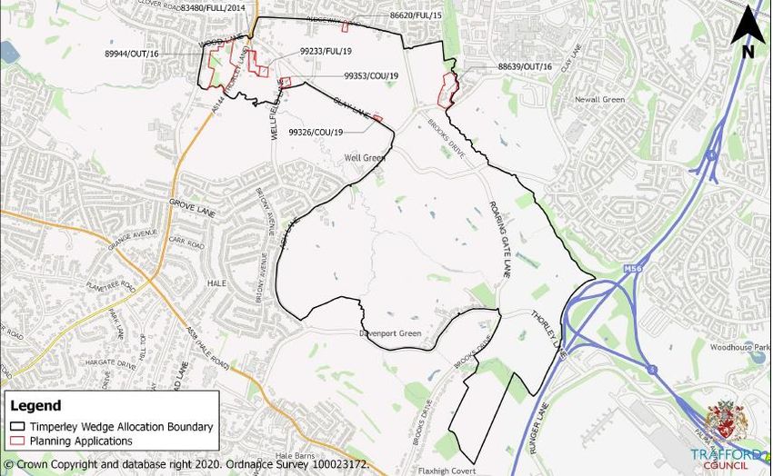
4.0   Proposed Development

4.1   The site is proposed for the development of approximately 1,700 units within the plan
      period and around 2,500 residential units in total. There will be medium density
      development of 35 dwellings per hectare (dph) in the northern part of the allocation
      and higher density development of 70 dph close to a proposed new local centre at
      the Davenport Green Metrolink stop. This higher density is also appropriately located
      close to the proposed HS2 Manchester Airport station.

4.2   The housing is proposed to be a mix of houses and flats, housing an estimated
      population of around 5,500 based on ONS data for an average population by house
      type in Trafford. There is a requirement for a minimum of 45% of the housing to be
      affordable.

4.3   The allocation also proposes to deliver a minimum of 15,000 sqm of office
      employment land in plan period and around 60,000 sqm in total. The employment
      development will be located in the south-eastern area of the allocation at land known
      as “Davenport Green” which is not in Green Belt. A small amount of ancillary retail
      development is proposed to serve the development.

4.4   The development will be required to provide infrastructure to support the new
      community. This includes a new spine road through the site, more routes for walking
      and cycling, extended bus services including bus rapid transit, a new local centre
      with convenience shopping facilities, health facilities and a primary school.

4.5   There will be a large rural park of approximately 90 ha on the west side of the
      allocation, adjacent to Hale Barns that will remain in the Green Belt. Green corridors
      will run through the development and link the remaining Green Belt areas west of
      development through to Medipark in the east and other existing green corridors
      including Fairywell Brook and Brooks Drive. Other accessible green spaces will be
      provided throughout the allocation for sport, leisure and recreation.

4.6   The allocation also proposes an area of 11 ha of Safeguarded Land to the south-east
      and to the west of the proposed HS2 Airport Station for future growth post 2037. This
      would only be allocated after a Plan review has been undertaken, the rest of the
      allocation has been developed, and the HS2 station has been completed and it
      would only be for development that directly contributes to the Greater Manchester
      HS2 Growth Strategy. Until such time that the PfE Plan is reviewed and HS2 is

Timperley Wedge Site Allocation Topic Paper – PfE 2021                                     9
completed the land is protected from development and Green Belt policies will
continue to apply.
4.7 See Appendix A for PfE 2021 Policy JP3.2 Timperley Wedge
4.8 Key changes made to the Timperley Wedge allocation between GMSF 2019,
GMSF 2020 :-
Inclusion of Timperley Wedge and Medipark as a cross boundary allocation with a
map showing the location of the allocations together and wording setting out the
opportunities for the integration of the infrastructure for the allocations and the
wider benefits they can bring to the local area collectively
Total residential quantum at Timperley Wedge has increased slightly from 2,400 to
2,500 units
There is a reduction of development within the plan period to 1,700 dwellings and
15,000 sqm of employment floorspace up to 2037 as a result of HS2 requiring the
temporary use of some of the allocation land for construction
The location of the Safeguarded Land has changed so that it is closer to the HS2
line and the Manchester Airport Station
14ha more land is to be retained in the Green Belt
An increase in the affordable housing requirement from a minimum of 30% to a
minimum of 45%. The 2019 policy took a cautious approach due to the unknown
infrastructure and viability costs. However in GMSF 2020 and PfE 2021 with
further evidence from the Trafford Housing Needs Assessment 2019 and the
viability appraisal demonstrating a positive outcome for viability with 45%
affordable housing, the policy was amended to better meet the acute demand for
affordable housing in the area.
4.9 Minor changes made to the Timperley Wedge allocation between GMSF 2020
and PfE 2021. The only changes have been:-
A change in wording of policy 36 as requested by Historic England following their
review of the GMSF 2020 wording. The change ensures that the Policy clearly
integrates Historic Impact Assessment (HIA) as a requirement of the allocation
policy.
Deletion of the words “to be agreed with TFGM” (Transport for Greater
Manchester) in Policy 15 as it is not possible for a Local Plan policy to require a
third party to agree to a planning requirement other than with the Local Planning
Authority
Timperley Wedge Site Allocation Topic Paper – PfE 2021 10 Correction of the full name of Wythenshawe Hospital from University Hospital
South Manchester to Manchester University NHS Foundation Trust Wythenshawe
Hospital.
4.10 See Appendix B for GMSF 2020 Policy 3.2 and Appendix C for GMSF 2019 Policy
GM49.
5.0 Site Selection
5.1 In the draft GMSF 2019, the site selection process identified sustainable locations for
residential and employment development that could achieve the GMSF Vision,
Objectives and Spatial Strategy. The draft GMSF 2019 Site Selection Topic Paper
has been updated to reflect changes in GMSF 2020 and PfE 2021, although the
methodology remains the same. The PfE Site Selection Topic paper is available
here: https://www.greatermanchester-ca.gov.uk/placesforeveryone
5.2 The methodology for site selection includes seven site selection criteria which have
been informed by the Vision, Objectives and Spatial Strategy in the draft PFE 2021
and were used to guide the selection of sites for potential allocation.
5.3 Broad Areas of Search were identified which met at least one of the site selection
criteria. These were mostly in locations where sites were submitted as part of the
“call for sites” process in GMSF 2016.
5.4 An Area of Search Tr/Ma-AS-1 Manchester Airport/HS2/Roundthorn/Medi Park was
identified around a cluster of call for sites. This Area of Search meets the following
PfE 2021 site selection criteria:-
Criterion 2- The site is close to the key assets of Manchester Airport and the
proposed HS2 Manchester Airport Station. Employment development at this
location can take advantage of links to these assets.
Criterion 5 - Development has the potential to have a regenerative impact on
deprived communities located to the east.
Criterion 6 - The site can take advantage of the planned Metrolink Western Leg
extension, as well as wider east/west improvements to Altrincham, the Airport and
Stockport.
Criterion 7 - The large number of new homes that can be supplied at Timperley
Wedge alongside office employment allows the creation of a new sustainable
Timperley Wedge Site Allocation Topic Paper – PfE 2021 11place, creating jobs and new homes together in a strong and desirable market
area to meet the range of family housing needed in the south of the Borough.
5.5 From within the Area of Search, detailed allocation boundaries were produced for
two adjacent allocations at Timperley Wedge and Medipark.
5.6 At Timperley Wedge only the land required to meet housing needs is proposed for
Green Belt release and the options for which of the call for sites could best deliver
this were assessed through consideration of the sustainability of each of the call for
sites within the Area of Search and an overall consideration for minimising harm to
Green Belt.
5.7 There were 11 call for sites within the Area of Search not proposed for allocation.
These were located closer to Hale and Well Green in areas with predominately more
open countryside.
5.8 In order to minimise harm to Green Belt it is proposed to maintain the separation of
Hale and Timperley, with a corridor of Green Belt from the south of the site through
to Altrincham. Therefore only the northern and eastern part of Timperley Wedge is
proposed for development. These areas are considered more preferable for
development as they have more brownfield land and urbanising features within them,
are closest to development opportunities in Manchester at Wythenshawe Hospital
and Medipark and are closest to Davenport Green, an area not in the Green Belt and
already proposed for future development.
6.0 Planning History
6.1 Figure 2 shows the recent planning history within the allocation boundary considered
to be relevant to the proposed allocation:
Application 83480/FULL/2014
Land at Clay Lane Nurseries, Thorley Lane, Timperley WA15 7AF
Proposal: Change of use from garden nursery to airport car parking
Status: Refused February 2015, but subsequently approved on appeal June 2015.
Application 88639/OUT/16
Land at Dobbinets Lane Hale WA15 7TU
Proposal: Residential development off Dobbinets Lane, comprising 13 dwellings
Status: Application withdrawn December 2016.
Timperley Wedge Site Allocation Topic Paper – PfE 2021 12Application 89944/OUT/16
Land at World of Pets, Thorley Lane, Timperley WA15 7PJ
Proposal: Residential development comprising 23 dwellings
Status: Refused February 2017.
Application 86620/FUL/15
Land Adjacent To 74 Ridgeway Road Timperley WA15 7HD
Proposal: Residential development comprising 2 dwellings
Status: Disposed January 2019.
Application 99326/COU/19
Land at Holly Tree Cottage, Clay lane, Timperley WA15 7TS
Proposal: Change of use from residential dwelling (Use Class C3) to serviced
accommodation (Use Class C1) at Holly Tree Cottage, Clay Lane
Status: Approved with conditions May 2020.
Application 99353/COU/19
Land at Paddock Farm, Wellfield Lane, Timperley WA15 7AD
Proposal: Change of use from residential dwelling (Use Class C3) to serviced
accommodation (Use Class C1) at Paddock Farm
Status: Approved with conditions May 2020.
Application 99233/FUL/19
Land at Clay Lane Nurseries, Thorley Lane, Timperley WA15 7AF
Proposal: Change of use of land from nursery use to a mixed use of airport car
storage, builder's storage and nursery use
Status: Refused February 2020. Appeal lodged then Dismissed July 2020.
Timperley Wedge Site Allocation Topic Paper – PfE 2021 13Figure 2: Planning applications at Timperley Wedge
7.0 GMSF 2019 Consultation Responses
7.1 The consultation responses and consultation summary report , October 2020 is
available here: https://www.greatermanchester-ca.gov.uk/placesforeveryone
7.2 A total of 944 comments were submitted on the Timperley Wedge allocation.
7.3 Comments supporting the Timperley Wedge allocation said it will help meet the
shortfall in residential and commercial development and also that it is on the edge of
an existing settlement close to amenities and the airport. There were also supportive
comments made recognising that there is high market demand for the type of
development proposed and support for more investment in public transport. Some
comments supported development of HS2 and the Metrolink extension and the
allocation taking advantage of the growth and investment generated by these
projects as well as taking advantage of employment growth at the Airport. The
majority of landowners within the allocation boundary area sent in a response in
support of the development.
7.4 There was support for affordable housing in the area, with responses stating that the
(then) 30% requirement should be higher because it is an expensive area.
Timperley Wedge Site Allocation Topic Paper – PfE 2021 147.5 A large number of people objected to Green Belt loss, particularly its role as an
important green buffer filtering noise and air pollution created by the expanding
Airport from residential areas. Concerns were also raised that this is the final green
space between Altrincham and Manchester Airport. Other objections to Green Belt
loss stated that it is wrong to build on Green Belt until all other options have been
exhausted and that Trafford has a relatively small percentage of Green Belt
compared to other Greater Manchester boroughs. There were also comments saying
that there is a danger of merging the character of different residential areas together
and that instead of developing on Green Belt, more brownfield land and empty
homes should be identified.
7.6 Concerns were raised that the roads are already too congested and they will not
cope with the additional traffic the development would bring to the area. There were
objections to roads being widened and the destruction of trees and hedgerows along
the country lanes as a result of this. There were also concerns raised that existing
infrastructure such as doctors, dentists, Wythenshawe Hospital, police, fire
department, schools etc. will not cope with increased pressures from the new
development and that these need more investment.
7.7 Comments were made that development will harm the environment, wildlife habitats,
landscape character and ancient trees/hedgerows. However it was noted there are
opportunities for biodiversity net gain. There were also comments that the proposals
will remove green open space including existing playing fields that people enjoy.
7.8 It was questioned whether the site can accommodate the proposed quantum of
development without harm to heritage assets and that this needs further
investigation.
7.9 Other concerns included increased air pollution and increased flood risk. However it
was suggested there are opportunities for net gain in flood storage for the wider
catchment and/or actively reducing flood risk impacts downstream.
8.0 GMSF 2019 Integrated Assessment
8.1 The Integrated Assessment (IA) document is available here:
https://www.greatermanchester-ca.gov.uk/placesforeveryone
Timperley Wedge Site Allocation Topic Paper – PfE 2021 158.2 The IA reviewed how the draft GMSF 2019 policies could impact upon the
environment, the economy, local communities/wider society, equality/discrimination
and public health against a set of IA objectives. The IA also recommended ways in
which the GMSF 2019 could be improved to ensure policies are as sustainable as
possible.
8.3 The allocation policy performed positively against the IA objectives relating to
housing, employment, transport investment, sustainable transport, deprivation,
equality of opportunity, health, social infrastructure, education, biodiversity, green
infrastructure, flooding, water resources, energy efficiency and the historic
environment.
8.4 The policy wording performed negatively against the IA objective for improving air
quality because an Air Quality Management Area is adjacent to the allocation.
8.5 The policy performed negatively against ensuring that land resources are used in an
efficient way (IA objective 17) because the site is greenfield in Grade 3 agricultural
use and so does not support development of previously developed land, protect
best/most versatile agricultural land or encourage development of
derelict/contaminated land.
8.6 The policy performed neutral against the IA objectives relating to utilities/digital
infrastructure, climate change, low carbon energy, consumption of resources and
waste.
8.7 IA recommended changes to strengthen the policy for the Timperley Wedge
allocation including:
Reference links to wider green network.
Make specific reference to energy efficiency of housing stock.
Consider how housing land can enhance workforce skills and training.
Consider feasibility study into requirements of local utilities/digital infrastructure to
support development.
Benefits from the development should be maximised to benefit deprived areas.
Ensure new community infrastructure is accessible to all and that local capacity is
considered throughout future masterplanning stages.
Seek to minimise the number of trips by private car to/from the site.
Timperley Wedge Site Allocation Topic Paper – PfE 2021 16 A suitable flood risk assessment may be required and appropriate flood risk
mitigation should be implemented for all developments within or near to areas of
flood risk.
Make reference to low carbon and renewable energy.
Consider heritage assets throughout detailed design to reduce risk throughout
construction phases.
Consider how development of Previously Developed Land (PDL) sites could be
encouraged as a result of greenfield development (e.g. by incentives or inclusion
of adjacent PDL).
Investigate whether impacts on grade 3a agricultural land can be
avoided/minimised.
Promote sustainable construction methods.
Consider waste and recycling facilities in design.
8.8 It is important to note that the GMSF 2019 IA was focusing on each policy in isolation
from other policies and that many of the recommended changes for the Timperley
Wedge allocation policy were already addressed by other GMSF 2019 policies.
However some wording changes to the allocation policy for Timperley Wedge in
GMSF 2020 have been made as a result of the GMSF 2019 IA to improve links with
the wider green network, infrastructure phasing and flood risk.
9.0 GMSF 2020 Integrated Assessment
9.1 Taking the findings of the GMSF 2019 Integrated Assessment (IA) into account, the
policy wording for the allocation in GMSF 2020 was strengthened in the following
areas:
A local labour and skills plan/agreement will now set out how employment and
training opportunities for local people (particularly through the construction phase
of the allocation) can be created.
Appropriate solutions to providing decentralised low carbon heat and energy as
part of the new development will need to be explored and delivered.
The design of new buildings and development layouts will be required to maximise
the amount of renewable energy that can be generated via green technologies,
and linked to the supply of electric vehicle charging infrastructure.
Provision for other necessary infrastructure such as utilities, broadband and
electric vehicle charging points will now be required.
Timperley Wedge Site Allocation Topic Paper – PfE 2021 179.2 The IA of the GMSF 2020 is available here: https://www.greatermanchester-
ca.gov.uk/placesforeveryone. The changes to the Timperley Wedge GMSF 2020
allocation policies scored more positively than in 2019. These changes have been
retained in the PfE Plan 2021.
9.3 A 2021 PfE Integrated Appraisal Addendum has been produced and has reviewed
the changes made between GMSF 2020 and PfE 2021. As there have been no
substantial changes to this specific allocation between GMSF 2020 and PfE 2021
and the 2020 IA recommendations which had been incorporated into the GMSF 2020
remain in the PfE Policy, there has been no change to the assessment of this Policy
in relation to the IA Framework since 2020.
Timperley Wedge Site Allocation Topic Paper – PfE 2021 18Section B – Physical
10.0 Transport
Transport Connectivity
10.1 The existing roads through the site are limited in capacity and do not provide a
strategic link between Altrincham and Timperley to the north and Manchester Airport
and communities to the south. A new spine road will link Timperley and the proposed
interchange for HS2 and NPR at the Manchester Airport Station. The spine road will
be a key route for bus services with the potential for future rapid bus transit. Other
routes will be enhanced to promote pedestrian and cycling connections.
10.2 The allocation currently has a number of footpaths and rights of way within it.
Although Brooks Drive is not a public right of way, it is an important existing route for
pedestrians and cyclists. Existing footpaths and rights of way shall be retained and
enhanced. Additional routes provide recreation opportunities and link up to public
transport including Metrolink stops.
10.3 Timperley Wedge will link up to the surrounding cycle and pedestrian network
including the TFGM (Transport for Greater Manchester) routes, the National Cycle
Network routes and the proposed Bee Network, which is a proposal to have a fully
joined up cycling and walking network across Greater Manchester.
10.4 Currently the closest Metrolink stops to the allocation are at Altrincham, Roundthorn
and Manchester Airport, which are all in excess of 20 minutes walking travel time.
TFGM is planning to extend the existing Metrolink network with three new stops as a
new western leg route to Manchester Airport. Two of these stops will be located
within the allocation close to Davenport Green and the HS2 Manchester Airport
Station and integrated into the development
Transport Locality Assessment (2020)
10.5 The Locality Assessment for the Timperley Wedge allocation has been carried out as
a joint assessment with the adjacent Medipark allocation within Manchester. As both
allocations will collectively impact on existing road infrastructure in both areas the
mitigations proposed address both site specific transport requirements as well as
more strategic proposals. The Locality Assessment for Trafford is available here:
https://www.greatermanchester-ca.gov.uk/placesforeveryone
Timperley Wedge Site Allocation Topic Paper – PfE 2021 1910.6 The Locality Assessment assessed new trip generation and distribution of traffic as a
result of development on the site. The Locality Assessment concluded that
development of the allocations at Timperley Wedge and Medipark (both in isolation
and in consideration of the cumulative impacts with other nearby PfE 2021
allocations) are expected to materially impact both the strategic and local road
networks.
10.7 The impact on the strategic road network is expected to be concentrated between
junctions 3 and 6 of the M56. The local road network impacts are expected to mostly
be on the road network adjacent to Manchester Airport (i.e. the links immediately
north of the site including Dobbinetts Lane and the routes to the west of the site
including Thornley Lane). Through the site itself a new spine road to take traffic away
from the existing country lanes and upgrades to parts of Clay Lane will be the main
interventions needed. Masterplanning has used this indicative route to illustrate how
development parcels could be accessed directly from the road. However further
Transport Assessments would be required as part of planning applications to provide
more definitive route and access points. In addition, further work will be needed to
establish how the spine road route would interact with the Metrolink line and HS2
Manchester Airport Station.
10.8 The modelling and analysis work undertaken has used what it considers to be a
‘worst case’ scenario (which does not take into full account the extensive
opportunities for active travel and public transport improvements in the wider area).
Based on this modelling a series of mitigation measures have been developed and
tested to address the expected network congestion impacts on both the strategic and
local road networks.
10.9 To support Timperley Wedge and Medipark, the local junction modelling undertaken
as part of the Locality Assessment has identified the following list of mitigation
measures:
Timperley Wedge Site Allocation Topic Paper – PfE 2021 20Table 1: Mitigation Measures from Locality Assessment
Mitigation Description
Site Access
Alder Drive T Junction
Dobbinetts Lane Priority three arm junction
A5144 Thorley Lane/Clay Lane/Wood The link road access to the west of the site is
Lane proposed to create a new access onto
Thorley Lane south of the junction with Clay
Lane and Wood Lane. The new access would
be a mini roundabout. The roundabout at
Clay Lane and Wood lane would remain as it
is and Clay lane will be changed to access
only and blocked off at its junction with the
new spine road.
Necessary Strategic Interventions
Timperley Wedge Spine Road To support the site a new spine road through
the centre of the site is proposed, which runs
from Thorley Lane in the north (new three
arm roundabout), across the M56 motorway,
to Runger Lane in the south
Roundthorn Medipark Spine Road To support the site a new spine road through
the centre of the site is proposed, which runs
from Floats Road in the north (new signalised
junction), across Whitecarr Lane, to
Timperley Wedge Spine Road in the south
(signalised junction). Including bridge over
Fairywell Brook
Supporting Strategic Mitigations
Bus Rapid Transit (BRT) BRT link from Altrincham to Manchester
Airport through site, running along spine road.
Metrolink Western Leg Extension Metrolink western leg extension from
Roundthorn to Newall Green/Timperley
Wedge, including a turnback.
Necessary Local Mitigations
Whitecarr Lane Blocking access to through traffic
Clay Lane/Barnacre Avenue Blocking access to through traffic
Clay Lane Blocking access to through traffic. The new
Timperley Wedge Spine Road will provide a
new access on to Thornley Lane at the
western end of the site south of the junction
with Clay Lane and Wood Lane. It is
proposed therefore to block access to through
traffic at this point (also see mitigation at
junction 17 A5144 Thornley Lane/Clay Lane/
Wood Lane).
Dobbinetts Lane / Floats Road Replace the three arm priority junction with a
three arm signalised junction
Timperley Wedge Site Allocation Topic Paper – PfE 2021 21Mitigation Description
Dobbinetts Lane It is proposed to widen Dobbinetts lane to a
suitable standard; this will require widening of
specific sections rather than the whole length.
The upgrade will provide a route to a suitable
standard to accommodate the level of traffic
from both GM3.1 and GM3.2.
Thorley Lane/Runger Lane Separate left turn stage from Thorley Lane to
run with Thorley Lane North arm
Terminal 2 Roundabout Replace the existing priority roundabout with
a fully signalised roundabout.
Bus gate at Clay Lane Bus gate giving priority to BRT services along
Clay Lane
Provision for future Bus Rapid Transit BRT proofing Timperley Wedge Spine Road;
(BRT) also provision of BRT stops.
Bus service improvements Extension of 102 through the site at current 2
buses per hour
Metrolink stop Metrolink stop on Western Leg extension to
serve allocation
Strategic Road Network
(SRN)Interventions
M56 Junction 3 A new free flow bypass lane from the
western local road arm to the M56 on slip and
localised widening on the eastern arm.
Figure 3: The indicative vehicle access points from the spine road and the existing
and proposed active routes
Timperley Wedge Site Allocation Topic Paper – PfE 2021 22Transport Locality Assessment Addendum 2021
10.10 The conclusions of the Transport Locality Assessment 2020 have been reviewed for
PfE 2021 to ensure they remain valid following changes from the GMSF 2020,
primarily the withdrawal of Stockport Council and therefore the removal of the
proposed Stockport allocations. Full details are in the Addendum report available at:
www.greatermanchester-ca.gov.uk/placesforeveryone
10.11 The review did not identify any significant changes in the modelling or proposed
transport interventions. A minor change has been made to the proposed mitigation at
Junction 3a of the M56 and an indicative mitigation scheme has also been included
for Junction 6 of the M56.
10.12 At the M56 Junction 6 work is also underway as part of a study to develop a strategic
approach to mitigate the significant impacts of HS2, NPR and other major
developments including PfE and Airport City in the vicinity of Manchester Airport, all
of which will impact the M56 Junction 6 area. This multi modal highway and transport
study will develop an approach to mitigating the impact on the M56 which can be
implemented in phases over a period of time as developments are realised.
10.13 As with the previous Locality Assessment, full Transport Assessments will be
required for the development plots to consider the issues in more detail and ensure
the potential mitigation measures remain appropriate as the allocation moves
through the planning process. The allocation will also need to be supported by
continuing wider transport investment across Greater Manchester.
11.0 Flood Risk and Drainage
11.1 The Greater Manchester Strategic Flood Risk Assessment (SFRA) highlighted the
key strategic flood risks and recommended key priorities for intervention taking
account of previous, existing and planned interventions. The SFRA focused on the
management of flood risk issues of importance to Greater Manchester as a whole
and did not include any site specific references to Timperley Wedge. The SFRA is
available here: https://www.greatermanchester-ca.gov.uk/placesforeveryone
11.2 The majority of the allocation is in Flood Zone 1 (i.e. land assessed as having a
lower than 1 in 1000 annual probability of river flooding) and is the lowest risk flood
zone. Development is not proposed on flood zones 2 and 3.
Timperley Wedge Site Allocation Topic Paper – PfE 2021 2311.3 Small sections of the site contain flood zones 2 and 3, including Fairywell Brook and
Timperley Brook. Existing flood risk at Fairywell Brook is at low lying land near the
intersection with Dobinetts Lane and also where it intersects Whitecarr Lane. The
Masterplan proposes the areas at Whitecarr lane and Dobbinetts lane are left
undeveloped as green infrastructure areas.
11.4 Flood zone 3 along Timperley Brook covers a stretch of land to the east of Clay
Lane/Ash Lane that is to be retained as Green Belt. Remediation works may be
necessary to prevent flooding downstream.
11.5 There is existing flood risk from surface water on Clay Lane and also where
Timperley Brook approaches Roaring Gate Lane. During periods of substantial
rainfall, new surface water tributaries of Timperley Brook develop, and in some
places these cross into proposed development land.
11.6 Development of the Timperley Wedge allocation will be required to address flood risk
and water management through the design and layout of development and in
accordance with a comprehensive drainage strategy. The strategy must
demonstrate how each phase interacts with other phases of development and further
detail will be set out in the Masterplan / Supplementary Planning Document.
11.7 Flood risk management measures could include allocating land for water storage
within the landscape through Sustainable Drainage Systems (SuDS). As the site is
not directly adjacent to these areas downstream that are affected by flooding,
landscaping to create more storage is likely to be more effective than walls or
conveyance improvements. It would also be more cost effective and provide wider
natural capital benefits. However careful consideration needs to be given to a risk of
bird strike from any open water areas given the close proximity of Manchester
Airport. Surface water drainage issues on Timperley Brook can be largely managed
within green infrastructure and drainage issues will need to be well managed within
any proposed development areas. A swale SuDS scheme along the route of the new
spine road through the site will also help address existing and future risks of surface
water flooding.
Timperley Wedge Site Allocation Topic Paper – PfE 2021 2412.0 Ground Conditions
12.1 The land is broadly flat. Moreover, the land is primarily greenfield and has been used
for agricultural or sporting facilities such that it is not anticipated that there will be any
constraints associated with pollutants. Detailed assessments of the ground
conditions will be undertaken prior to the submission of any future planning
application(s).
13.0 Utilities
13.1 United Utilities has provided direct input into the masterplanning process. The
allocation currently has limited utilities infrastructure due to its primary use as
farmland. Improvement to the utilities provision will be required to support
development on the site. An existing United Utilities sewer which is pressurised
crosses the centre of the area east to west as set out in figure 4 (on page 26). This
needs to be avoided and an appropriate easement gap considered by any
development layout. An existing easement also runs along the northern section of
Brooks Drive. Care will need to be given to how new developments tie into existing
networks. Early infrastructure improvements should also take into account later
phased works to provide capacity for later developments to tie in to it. Developments
towards the south will require more infrastructure provision than those further north.
14.0 Other Constraints
14.1 Maximum heights of buildings will need to be within the parameters as defined by
their proximity to Manchester Airport to ensure flight safety. Building height is limited
to 15m in the south and east of the site and 45m in the north-west. Any heights in
excess of these parameters are subject to consultation with Manchester Airport.
14.2 Existing overhead power lines run across the southern parts of the allocation north-
west to south-east and west to east across the centre of the site. The appropriate
easements will need to be considered as part of any planning application(s).
Timperley Wedge Site Allocation Topic Paper – PfE 2021 25Figure 4 Line of existing Sewer across Timperley Wedge Timperley Wedge Site Allocation Topic Paper – PfE 2021 26
Section C – Environmental
15.0 Green Belt Assessment
15.1 To deliver the scale of growth required to meet the housing and employment needs
of Trafford and other GM authorities covered by the PfE 2021, some Green Belt land
will need to be released.
15.2 At Timperley Wedge, Green Belt release is required to deliver the proposed
development and new Green Belt boundaries will therefore be established. The
boundaries will, where possible, utilise existing strong defensible features (such as
roads or tree belts) or they will be created / strengthened through green
infrastructure and landscaping. A strategic Green Belt corridor will be retained
throughout the allocation separating new development from Hale Barns.
15.3 The proposed revision to the Green Belt has been informed by several studies
undertaken by consultants (LUC):-
The Greater Manchester Green Belt Assessment July 2016
Stage 2 Greater Manchester Green Belt Study Assessment of proposed 2019
GMSF Allocations – September 2020
Stage 2 Greater Manchester Green Belt Study Addendum Assessment of
proposed 2020 GMSF Allocations – September 2020
Stage 2 Greater Manchester Green Belt Study Contribution Assessment of
Proposed 2020 GMSF Green Belt Assessment Additions - September 2020
Stage 2 Greater Manchester Green Belt Study Cumulative Assessment of
Proposed 2020 GMSF Allocations and Additions September 2020
Stage 2 Greater Manchester Green Belt Study – Identification of Opportunities to
Enhance the Beneficial Use of the Green Belt September 2020
Stage 2 GM Green Belt Study – Cumulative Assessment of Proposed 2021 PfE
Allocations and Additions
15.4 These documents are available here: https://www.greatermanchester-
ca.gov.uk/placesforeveryone
Timperley Wedge Site Allocation Topic Paper – PfE 2021 27GM Green Belt Assessment 2016
15.5 The Greater Manchester Green Belt Assessment 2016 assessed the extent to which
the land within it performed against the purposes of Green Belts, as set out in the
National Planning Policy Framework (2012). Timperley Wedge was included within
Strategic Green Belt Area 24 of the assessment. The assessment was undertaken
against 4 of the purposes of Green Belt and each strategic area was assessed and
scored with a rating from strong through to moderate and then weak. The results
were as follows:
Purpose 1: To check the unrestricted sprawl of large built up areas: Strong
Purpose 2: To prevent neighbouring towns from merging into one another:
Moderate
Purpose 3: To assist in safeguarding the countryside from encroachment: Weak-
Moderate
Purpose 4: Preserving the setting and special character of historic towns: Weak
Stage 2 GM Green Belt Assessment of proposed 2019 GMSF Allocations
15.6 In 2019 LUC carried out a study to assess the potential harm to the Green Belt that
could result from the release of Green Belt land within allocations proposed in the
GMSF 2019.
15.7 A summary of the overall harm to the Green Belt as a result of the release of specific
parcels is set out below. The location of the parcels can be identified in Figure 5.
GM46-1, Land to the south of Ridgeway Road: The overall harm to the Green
Belt from release of this sub-area would be Moderate. Release of this sub area
would constitute relatively limited sprawl and encroachment on the countryside,
and a relatively limited impact on preventing the merger of towns. It would
constitute a minor weakening of retained Green Belt land.
GM46-2, Land to the north of Clay Lane and west of Dobbinets Lane: The
overall harm to the Green Belt from release of this sub-area would be High.
Release of this sub area would constitute relatively significant sprawl and
encroachment on the countryside, and a relatively significant impact on preventing
the merger of towns. The release would constitute a minor weakening of retained
Green Belt land.
GM46-3, Land to the north of Ridgeway Road and to the west of Brooks
Drive: The overall harm to the Green Belt from release of this sub-area would be
Timperley Wedge Site Allocation Topic Paper – PfE 2021 28Moderate. Release of this sub area would constitute relatively significant sprawl
and encroachment on the countryside, and a moderate impact on preventing the
merger of towns. The release would constitute a negligible weakening of retained
Green Belt land.
GM46-4, Land to the south of Alder Drive: The overall harm to the Green Belt
from release of this sub-area would be Moderate. Release of the sub-area would
constitute relatively significant sprawl and encroachment on the countryside, and a
moderate impact on preventing the merger of towns. The release would constitute
a negligible weakening of retained Green Belt land.
GM46-5, Land along Whitecarr Lane and Roaring Gate Lane: The overall harm
to the Green Belt from release of this sub-area would be Very High. Release of
this sub area would constitute significant sprawl and encroachment on the
countryside, and a significant impact on preventing the merger of towns. It would
constitute a moderate weakening of retained Green Belt land.
GM46-6, Land bounded by Brooks Drive, Dobbinnets Lane and Whitecarr
Lane: The overall harm to the Green Belt from release of this sub-area would be
Moderate. Release of this sub area would constitute relatively significant sprawl
and encroachment on the countryside, and a moderate impact on preventing the
merger of towns. The release would constitute only a negligible weakening of
retained Green Belt land.
GM46-7, Land to the south of Thorley Lane: The overall harm to the Green Belt
from release of this sub-area would be Moderate. Release of this sub area would
constitute moderate sprawl and encroachment on the countryside, and a relatively
limited impact on preventing the merger of towns. The release would also
constitute a minor weakening of retained Green Belt land.
GM46-8, Land to the west of Roaring Gate Lane: The overall harm to the Green
Belt from release of this sub-area would be High. Release of this sub area would
constitute relatively significant sprawl and encroachment on the countryside, and a
relatively significant impact on preventing the merger of towns. It would constitute
a minor weakening of retained Green Belt land.
Timperley Wedge Site Allocation Topic Paper – PfE 2021 29You can also read