SPATIAL DEVELOPMENT FRAMEWORK - 2013 LOCAL MUNICIPALITY uMNGENI - uMngeni Municipality
←
→
Page content transcription
If your browser does not render page correctly, please read the page content below
uMNGENI
             LOCAL MUNICIPALITY

SPATIAL DEVELOPMENT FRAMEWORK
              2013

                           JUNE 2013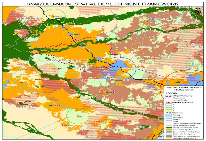
1

                                                                       TABLE OF CONTENTS

1 BACKGROUND ................................................................................................................................................................... 2

2 PURPOSE ............................................................................................................................................................................. 2

3 LEGISLATION AND POLICY ................................................................................................................................................ 2

4 SDF OBJECTIVES ARISING FROM THE IDP’S STRATEGIC FRAMEWORK .......................................................................... 15

5 POLICY LEVEL DEVELOPMENT INFORMANTS .................................................................................................................. 15

6 AN INTEGRATED AND STRATEGIC APPROACH TO DEVELOPMENT AND LAND USE MANAGEMENT .......................... 16

7 GUIDELINES FOR A LAND USE MANAGEMENT SYSTEM .................................................................................................. 17

8 CAPITAL INVESTMENT FRAMEWORK ............................................................................................................................... 22

9 STRATEGIC ENVIRONMENTAL ASSESSMENT (SEA) OF SPATIAL FRAMEWORK ............................................................... 23

10 PROGRAMS AND PROJECTS FOR THE DEVELOPMENT OF LAND ................................................................................ 23

11 ALIGNMENT WITH NEIGHBOURING MUNICIPALITIES AND DISTRICT INTEGRATED DEVELOPMENT PLANS ................. 24

12 THE SPATIAL DEVELOPMENT FRAMEWORK MAP .......................................................................................................... 25

13 DEVELOPMENT INFORMANTS ........................................................................................................................................ 26

14 THE PRIMARY NODE ....................................................................................................................................................... 40

15 SECONDARY NODES...................................................................................................................................................... 42

16 URBAN EDGES ................................................................................................................................................................ 42

17 THE ZONES IN THE PRIMARY AND SECONDARY NODES............................................................................................... 43

18 THE RURAL COMPONENT OF THE MUNICIPALITY .......................................................................................................... 45

19 OVERARCHING ENVIRONMENTAL CONSIDERATIONS ................................................................................................. 48

APPENDIX 1 – MAPPING………………………………………………………………………………………………………………..49

DISTRICT LEVEL EXTRACT PROVINCIAL SDF – Map 1
uMNGENI SPATIAL DEVELOPMENT FRAMEWORK 2013/2014 – Map 2
LAND CAPABILITY – Map 3
AGRICULTURAL POTENTIAL – Map 4
CRITICAL BIODIVERSITY AREAS – Map 5
ENVIRONMENTAL FEATURES – Map 6
LAND SUBDIVISIONAL PATTERN AND TOURISM FACILITIES – Map 7
LAND COVER – Map 8
LAND USE – Map 9
POSITION OF PDA APPLICATIONS – Map 10

ANNEXURE A – AGRICULTURAL ASSESSMENT

ANNEXURE B – SOCIAL ANALYSIS CENSUS 1996, 2001 AND 2011

ANNEXURE C – ECONOMIC OVERVIEW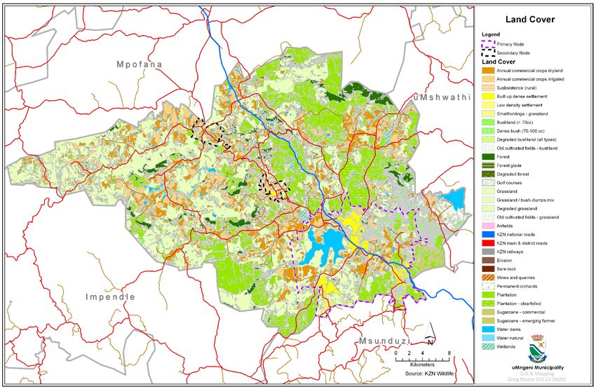
2

uMNGENI MUNICIPALITY: INTEGRATED DEVELOPMENT PLAN TO INFORM THE 2013/14
FINANCIAL YEAR: SPATIAL DEVELOPMENT FRAMEWORK 2013

1     BACKGROUND

The original Spatial Development Framework (SDF) was adopted as part of the uMngeni
Integrated Development Plan (IDP) by Council during June 2002. Council’s first IDP
Review included a review of the SDF, and was adopted by Council on 25 September
2003. The second IDP review was initiated in early 2004. Following advice from the
Province’s Department of Traditional and Local Government Affairs (DTLGA), the 2003 /
04 review was combined with the 2004 / 05 review. This allowed for the IDP review process
to catch up with the budgetary process. Once again, the SDF was reviewed and
amended as part of this process, and the reviewed IDP was adopted by Council on 23
March 2005.

These annual reviews of the SDF were mainly prompted by the following:

      •    to accommodate more up to date information, such as the rural cadastral
           data base, environmental data and land use information
      •    the increased pressure for development across the municipality
      •    the need to refine the boundaries of the primary and secondary nodes
      •    the need to provide guidelines on the management of development in the
           urban / rural interface
      •    to ensure that the broader planning is aligned to the latest regional,
           provincial and national development plans
      •    to incorporate the relevant findings and recommendations of more detailed
           planning studies, such as the N3 Corridor Management Plan (2009) and the
           Local Area Plan for the Hilton Central Area (2010)
      •    to ensure alignment with the SDF’s of adjoining municipalities.

The SDF has been the focus of extensive discussion at the IDP Representative Forum, the
previous LUMS Steering Committee (and its successor to guide the Municipal-wide
Scheme) and at a number of DFA hearings and a recent hearing by the PDA Appeal
Tribunal.

2     PURPOSE

The uMngeni Spatial Development Framework (SDF) reflects the spatial implications of
the other elements of the IDP, and is guided by those development informants, strategies
and development actions which have a spatial implication. It broadly informs decisions
relating to future development and service provision.

3     LEGISLATION AND POLICY

3.1   The SDF is guided by, amongst others, the following:

      •    the regulations promulgated in terms of the Municipal Systems Act
      •    the Development Facilitation Act (DFA)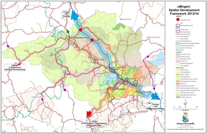
3

      •     the National Spatial Development Perspective (NSDP) and the National
            Development Plan
      •     the Provincial Growth and Development Strategy (PGDS) and the Provincial
            Growth and Development plan (PGDP) which are aligned to the National
            Development Plan (NDP)
      •     Provincial Spatial Economic Development Strategy (PSEDS)
      •     the uMgungundlovu Districts SDF

3.2 The Regulations promulgated in terms of the Municipal Systems Act, 2000 set out the
      following requirements for a Spatial Development Framework:

          “A spatial development framework reflected in a municipality’s integrated
                                  development plan must:

               (a) give effect to the principles contained in Chapter 1 of the
                   Development Facilitation Act, 1995 (Act No. 67 of 1995);
               (b) set out objectives that reflect the desired spatial form of the
                   municipality;
               (c) contain strategies and policies regarding the manner in which to
                   achieve the objectives referred to in paragraph (b), which strategies
                   and policies must-

                      (i)     indicate desired patterns of land use within the municipality;
                      (ii)    address the spatial reconstruction of the municipality; and
                      (iii)   provide strategic guidance in respect of the location and
                              nature of development within the municipality.

               (d)   set out basic guidelines for a land use management system in the
                     municipality;
               (e)   set out a capital investment framework for the municipality’s
                     development programs;
               (f)   contain a strategic assessment of the environmental impact of the
                     spatial development framework;
               (g)   identify programs and projects for the development of land within
                     the municipality;
               (h)   be aligned with the spatial development frameworks reflected in the
                     integrated development plans of neighboring municipalities; and

               (i)   provide a visual representation of the desired spatial form of the
                     municipality, which representation –
                     (ii)  must indicate where public and private land development
                           and infrastructure investment should take place;
                     (iii) must indicate desired or undesired utilization of space in a
                           particular area;
                     (iv)  may delineate the urban edge;
                     (v)   must identify areas where strategic intervention is required;
                           and
4

                    (vi)    must indicate areas where priority spending is required”.

3.3   The principles contained in the Development Facilitation Act (DFA)

Chapter 1 of the DFA sets out a number of principles which apply to all land
development. The following principles would apply to the formulation and content of a
Spatial Development Framework.

a.    Policies, administrative practice and laws should:

                    (vii)   provide for urban and rural land development;

                    (ii)     facilitate the development of formal and informal, existing
                             and new settlements;

                    (iii)    discourage the illegal occupation of land, with due
                             recognition of informal land development processes;

                    (iv)     promote speedy land development;

                    (v)      promote efficient and integrated land development in that
                             they:

                              •   promote the integration of the social, economic,
                                  institutional and physical aspects of land development;

                              •   promote integrated land development in rural and
                                  urban areas in support of each other;

                              •   promote the availability of residential and employment
                                  opportunities in close proximity to or integrated with
                                  each other;

                              •   optimize the use of existing resources including such
                                  resources relating to agriculture, land, minerals, bulk
                                  infrastructure, roads, transportation and social facilities;

                              •   promote a diverse combination of land uses, also at the
                                  level of individual erven or subdivisions of land;

                              •   discourage the phenomenon of “urban sprawl” in urban
                                  areas and contribute to the development of more
                                  compact towns and cities;

                              •   contribute to the correction of the historically distorted
                                  spatial patterns of settlement in the Republic and to the
                                  optimum use of existing infrastructure in excess of current
                                  needs; and
5

                              •   encourage    environmentally    sustainable        land
                                  development practices and processes.

b.    Members of communities affected by land development should actively
      participate in the process of land development.

c.    The skills and capacities of disadvantaged persons involved in land development
      should be developed.

d.    Policy, administrative practice and laws should promote sustainable land
      development at the required scale in that they should –

                    (viii)   promote land development which is within the fiscal,
                             institutional and administrative means of the Republic;

                    (ix)     promote the establishment of viable communities;

                    (x)      promote sustained protection of the environment’

                    (xi)     meet the basic needs of all citizens in an affordable way; and

                    (xii)    ensure the safe utilization of land by taking into consideration
                             factors such as geological formations and hazardous
                             undermined areas

e.    Each proposed land development area should be judged on its own merits and
      no particular use of land, such as residential, commercial, conservational,
      industrial, community facility, mining, agricultural or public use, should in advance
      or in general be regarded as being less important or desirable than any other use
      of land.

f.    Land development should result in security of tenure, provide for the widest
      possible range of tenure alternatives, including individual and communal tenure,
      and in cases where land development takes the form of upgrading an existing
      settlement, not deprive beneficial occupiers of homes or land or, where it is
      necessary for land or homes occupied by them to be utilized for other purposes,
      their interests in such land or homes should be reasonably accommodated in
      some other manner.

g.    A competent authority at national, provincial and local government level should
      coordinate the interests of the various sectors involved in or affected by land
      development so as to minimize conflicting demands on scarce resources.

h.    Policy, administrative practice and laws relating to land development should
      stimulate the effective functioning of a land development market based on open
      competition between suppliers of goods and services.

3.4   National Spatial Development Perspective and National Development Plan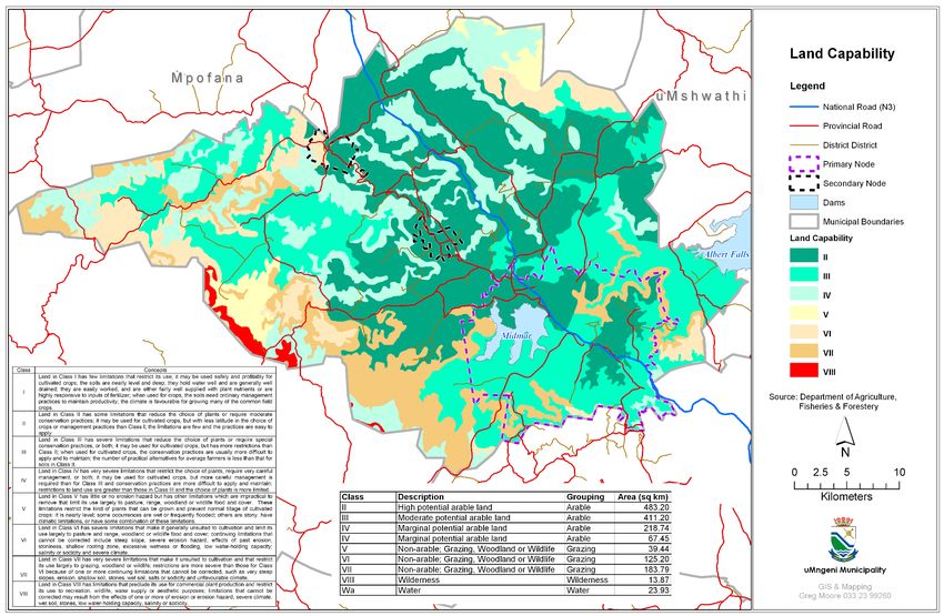
6

3.4.1 The National Spatial Development Perspective (NSDP) contains the following
       principles:
              • Principle 1: Rapid Economic growth that is sustained and inclusive is a
                   pre-requisite for the achievement of poverty alleviation.

             •       Principle 2: Government spending on fixed investment should be
                     focused on localities of economic growth and / or economic potential
                     in order to gear up private sector investment, stimulate sustainable
                     economic activities and create long-term employment opportunities.

             •       Principle 3: Where low economic potential exists investments should be
                     directed at projects and programmes to address poverty and the
                     provision of basic services in order to address past and current social
                     inequalities.

             •       Principle 4: In order to overcome the spatial distortions of Apartheid,
                     future settlement and economic development opportunities should be
                     channelled into activity corridors and nodes that are adjacent to or link
                     the main growth centres in order for them to become regional
                     gateways to the global economy.

      The National Spatial Development Vision reads as follows:

      “South Africa will become a Nation in which investment in infrastructure and
      development programmes support Government growth and development
      objectives:

                 ●   By focusing economic growth and employment creation in areas
                     where this is most effective and sustainable

                 ●   By supporting restructuring, where feasible, to ensure greater
                     competitiveness

                 ●   By fostering development on the basis of local potential

                 ●   By ensuring that development institutions are able to provide basic
                     needs throughout the country.”

3.4.2 The National Development Plan (NDP) sets the Vision of the country for the next 20
       years. The NDP is a roadmap to a South Africa where all have water, electricity,
       sanitation, jobs, housing, public transport, adequate nutrition, education, social
       protection, quality health care, recreation and a clean environment. The
       following slide illustrates how alignment with this plan is to be achieved.
7

      Source: COGTA presentation uMgungundlovu District IDP Forum Meeting 30 November 2012

3.5   Provincial Growth and Development Strategy and Provincial Growth and
      Development Plan

3.5.1 KZN has had a Provincial Growth and Development strategy (PGDS) since 1996, with
       2 review processes since then. In February 2011 the KZN Cabinet adopted the
       PGDS Review Framework.
       The purpose of the 2011 PGDS is to:

          •   Develop a clear long term vision and plan for the growth and development
              of the Province by building on the strengths and opportunities while
              addressing weaknesses and threats;
          •   Mobilize all development partners to achieve pre-determined
              development objectives and targets;
          •   Promote vertical, horizontal and spatial alignment;
          •   Spatially contextualize and prioritise (not just what also when and where) so
              as to achieve spatial equity;
          •   Guide the activities and resource allocation of Provincial Government and
              other spheres of government, business sectors, organized labour and other
              role players from civil society that can contribute to the development of
              the Province;
          •   Develop clean institutional arrangements to secure buy-in and ownership,
              through structured consultation processes with all sector and development
              parties;
          •   Define clear cut goals and indicators
          •   Direct commitment to the allocation of resources to manage and
              implement this PGDS;
8

           •    Build a strong centre and decisive outcomes and ensuring that the PGDS is
                afforded the status as the primary plan of the Province.

3.5.2 The PGDS report covers National and Provincial Policy Context; Current Status and
      Strategic Analysis; Vision, Goals, objectives and potential developmental
      interventions; and the Provincial Spatial and Development Framework.

3.5.3 The 7 Strategic Goals of the PGDS are:

           1.   Job Creation
           2.   Human Resource Development
           3.   Human and Community Development
           4.   Strategic Infrastructure
           5.   Environmental Sustainability
           6.   Governance and Policy 7. Spatial Equity.

3.5.4 The PGDS contains the Provincial Spatial Development Framework. With reference
      to Map 1, the majority of uMngeni is designated as an “Economic Support Area”.
      “Priority Conservation Areas” occur to the north along the Mooi and Karkloof
      Rivers, and the Mgeni River Valley is indicated as a “Biodiversity Priority Area”.
      Howick, Merrivale and Hilton are identified as “Areas of Economic Value Adding”.

        Various Economic Support Areas occur throughout the Province. The PGDS
        describes these areas as follows: “Due to the fact that these areas represent a
        larger distribution across the entire province than the core areas of economic
        value adding, these zones are considered important areas of Economic Support.
        Typical interventions in these areas would include economic prioritization of
        development, labour force interventions (e.g. skills development), key economic
        infrastructure investment and area promotion.”

        Areas of Economic Value Adding (Howick, Merrivale and Hilton) are described as
        “The Key economic centres where all of the varieties of economic sectors
        (Agriculture, Tourism, Manufacturing, and Services) are prevalent and perceived
        to have good potential to be further expanded upon. These areas are visibly
        linked to high accessibility areas with existing bulk infrastructure and relatively high
        population densities which would both contribute to the economic expansion and
        benefit from interventions in these areas. Due to these factors, further economic
        processing and value adding at a provincial level, are mainly proposed in these
        identified areas.”

3.5.5   The Provincial Spatial Development Framework recommends that the following
        nine spatial principles be applied in spatial planning at district and local level:
           • Principle of Sustainable Communities
           • Principle of Economic Potential
           • Principle of Environmental Planning
           • Principle of Sustainable Rural Livelihoods
           • Principle of Spatial Concentration
           • Principle of Local Self-sufficiency
           • Principle of Co-ordinated Implementation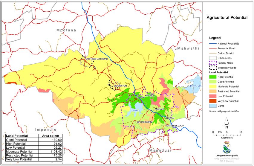
9

              •   Principle of Accessibility
              •   Principle of Balanced Development.

3.5.6   The Provincial Growth and Development Plan (2012) focuses on the
        implementation framework, namely, the institutional arrangements, activities and
        targets in respect of each intervention, monitoring, evaluation, reporting and
        reviewing mechanisms crucial to delivery of the PGDS as well as some catalytic
        interventions and major projects. (Refer to Map 1)

3.6     Provincial Spatial Economic Development Strategy (PSEDS)

3.6.1   The Provincial Spatial Economic Development Strategy (PSEDS) underlies the
        concepts of Nodes and Activity Corridors that have been brought forward into the
        Provincial Spatial Development Framework.

3.6.2   The PSEDS guides and informs the following:

          •       Spatial principles that will direct growth and development in the Province,
                  such as inter alia, principles of sustainability, the need to address historic
                  spatial imbalances, curbing urban sprawl and differentiated levels of
                  infrastructure provision;
          •       Identification of priority development areas, focusing on areas in which
                  specific types of development should be encouraged or discouraged;
          •       Strengthening or development of major movement routes or corridors;
          •       Identification of areas that have to be protected for biodiversity and
                  conservation purposes;
          •       The preparation of Municipal Spatial Development Frameworks, to ensure
                  full alignment of national, provincial and municipal spatial visions;
          •       Budgeting processes of all spheres of government to ensure that
                  government creates an environment conducive for development in the
                  prioritised areas; and
          •       The investment decisions of the private sector, not only in pursuance of
                  optimal returns, but also in support of a shared spatial vision for the Province.

3.6.3   In terms of the PSEDS, the Sectors of the provincial economy which will drive the
        growth of the province and address unemployment and poverty are the following
        sectors:

          •       Agriculture, including agri-industry (with opportunities to impact
                  considerably on the economic needs of the poor through Land Reform)
          •       Industry, including heavy and light industry and manufacturing
          •       Tourism, including domestic and foreign tourism
          •       Service sector including financial, social, transport, retail and government.

3.6.4 Nodes and Activity Corridors are identified in the PSEDS. These have been brought
      through into the PGDS SDF (see Map 1) and are to serve the following functions:

          •       To facilitate the increased growth of existing centres and corridors of
                  economic development in the Province; and
10
• To ensure that the potential for economic development within areas of high
poverty is realized.
3.6.5 The following critical threats are identified in the PSEDS:
(a) Agriculture and Land Reform
- Loss of productive commercial agricultural land to residential
development
- Loss of land with agricultural potential in poor rural areas
- Land reform resulting in a loss of productive commercial agriculture
- Municipal rates on agricultural land
- Provision of adequate water supplies
(b) Tourism
- Safety and Security
- Land invasion and illegal activities affecting tourism assets
(c) Industry
- Reliability of services
- Social support services
- Destructive Inter-Municipal competition
- Municipal rates on Industrial and commercial development.
3.6.5 The PSEDS identifies tourism as being second in importance to industrial
development, while agriculture and agri-business are seen as:
• Being the largest existing and potential employer in rural areas, and
• Being able to make the greatest impact on reducing poverty levels in rural
areas
Accordingly, high agricultural potential zones and tourism priority areas are
identified in the PSEDS.
3.7 District Municipality’s SDF
The District development context is that of a Core/Periphery Model which consists of a
strong well-developed core which contributes more than 85% of the district economy
and accommodates more than 75% of the population. The relatively weak periphery has
high levels of poverty and unemployment.
Through continued growth as illustrated by the Census and Economic Data (See
Annexures B and C of this report), it is clear that uMngeni is part of the dominant Core
District Economy and has to plan for a growing population. This means that while District
services backlogs cannot be ignored, there needs to be a District commitment to
upgrading and expansion of existing services in uMngeni.11
In order to ensure alignment of the local municipal SDF’s with that of the district, the
following concepts taken from the District SDF remain applicable.
3.7.1 Development Nodes
The District SDF is based on the concept of a hierarchy of nodes consisting of a
primary node, secondary nodes, tertiary nodes, rural nodes and a tourism node.
• The Primary Node, which consists of the urban complex of
Pietermaritzburg / Ashburton / Edendale. This is a centre with high levels
of economic development and the potential for growth and expansion,
serving the regional economy and beyond. This node is recognised as
an emerging metropolitan area.
• Secondary Nodes, which are urban centres with good existing levels of
economic development and the potential for above average
economic growth and development, serving the sub-regional economy
and beyond. The two proposed secondary nodes are the Howick /
Hilton / Mphophomeni complex and the Camperdown / Cato Ridge
area.
• Tertiary Nodes are centres with lower potential for economic growth
and a relatively high dependence on agriculture, providing services
mainly to the local economy. The proposed tertiary nodes are Mooi
River / Bruntville, New Hanover / Wartburg and Richmond.
• Rural Nodes are centres which fulfill the function of a rural service centre
to the surrounding area. The proposed rural nodes are Lidgetton, Dalton
/ Cool Air, Impendle and Vulindlela. It should however be
acknowledged that this type of node has the potential to provide a
wider range of services which will be determined by local conditions. It
is also possible that rural nodes can progress to the level of tertiary nodes
as economic and social conditions change. Typical services that can
be expected in these nodes can include Police Services, Administration
Services, Clinics, low level of Retail Services, Mobile Services, Pension
Payout points and a range of social facilities including community halls.
• Tourism Node: This node contains the villages of Rosetta and Nottingham
Road which fall in separate municipalities but form one functional unit.
Development in this node will primarily be of a tourism nature, and this
role needs to be consolidated and expanded. Given the location of the
node, the type of existing development and the additional recreation
and tourist potential that will be provided by the Spring Grove Dam, the
node should be seen as the northern gateway to the District’s Tourist
Routes, and should be planned accordingly. Environmental
conservation and the maintenance of water quality should be key
elements in the determination of potential development opportunities
in this area. Land uses which could detract from these functions or its
tourist potential should be discouraged.12
It needs to be kept in mind that this designation applies at a District level, and that
different designations would apply at local level. For example, the
Howick/Hilton/Mpophomeni/Midmar Dam area is the primary node in terms of the
uMngeni SDF, whilst in the district context it is classified as a secondary node. At the
provincial level, the converse would apply, with Msunduzi being classified as a secondary
node in the PSEDS.
3.7.2 Development Corridors
(i) The concept of development corridors is established in national and
provincial policies. The PSEDS identifies industrial development as a key
element to economic growth, with the primary zone of industrial potential
being the corridor linking the two port nodes of Durban and Richards Bay
and extending inland to Howick. Tourism is identified as the next provincial
priority, focusing on beach, cultural and eco-tourism.
(ii) The National Spatial Development Perspective (NSDP) sets the following
categories of economic development potential:
• Production of high value, differentiated goods not strongly dependent
on labour costs, focused on local & global niche markets – i.e.
manufacturing
• Production of labour intensive, mass produced goods more dependent
on labour costs, affordable transport linkages – i.e. agriculture and
mining
• Innovation and experimentation – research and development
• Retail and private sector services – large employer of skilled & semiskilled
workers in advanced economies
• Public service and administration.
(iii) In the PSEDS, two provincial priority corridors are identified, one of which,
(code-named PC2) runs from eThekwini through Msunduzi to uMngeni. This
is the central axis of the District, and the PSEDS states that it has the potential
to attract development in all the categories set in the NSDP.
(iv) In addition to this primary corridor, the PSEDS also identifies two secondary
corridors which run through the uMgungundlovu District, i.e.:
• Kokstad – Umzimkhulu – Msunduzi; and
• Msunduzi – Nkandla – Ulundi
Both these corridors are categorised as having the potential to attract
development in four of the six categories.
(v) The corridors suggested in this District SDF are based on the
recommendations in the PSEDS, the various development informants13
identified in the earlier phase of the study and the goals and objectives of
the SDF, with specific reference to:
• the need to integrate district space and link the various nodes and
opportunities into a meaningful whole;
• improve or extend access to areas with economic potential within areas
of high poverty;
• maximise interest opportunities and potentials within the district in way
which promotes growth and investment, and
• ensure the sustained growth of existing centres and corridors of
economic development.
(vi) Accordingly, the following corridors are suggested in the SDF:
(a) Provincial Priority Corridor (PC2)
Camperdown – Msunduzi – Mooi River (N3). The main function of this
corridor is as a limited access, long distance movement corridor.
However, along the urban component of the corridor it will attract the
full range of urban uses. This development pressure should be
accommodated on a planned basis, without undermining the corridor’s
primary function. In this way, environmental objectives will be served
and the existing and potential tourist routes can be protected.
Development plans for this corridor are being formulated by the local
Municipalities under the guidance of a Local Corridor Development
Work Group, chaired by the District.
(b) Strategic Integrated Project 2 (SIP2)
Since the establishment of the Local Corridor Development Work Group,
the National Infrastructure Development Plan (NIDP) was launched by
the Presidential Infrastructure Coordinating Committee (PICC) during
2012. The NIDP consists of 17 Strategic Integrated Projects (SIP’s), one of
which is the Durban-Free state-Gauteng Logistics and Industrial Corridor,
codenamed SIP2. The Local Corridor Development Work Group has
been absorbed into the SIP2 KZN Focus Group, which has been tasked
to deal with the eastern section of the corridor through the province.
The Focus Group is facilitated and chaired by the KZN Department of
Transport. In addition to DOT, the Focus Group is represented by DEDT,
ETA, Transnet, SANRAL, COGTA, the uMgungundlovu District
Municipality and all local municipalities along the corridor. The Focus
Group is in the process of commissioning the preparation of a N3
Corridor Plan that will provide an integrated framework for the
coordinated and orderly development of the corridor as a whole.14
(c) Primary Corridors:
The rationale for these corridors is provided by the PSEDS, and provides
the major linkages with the adjoining Districts to the north, south and
east. In some cases, these routes serve as alternative routes to the major
national routes. The primary function of these corridors is long distance
traffic movement, but development should be encouraged at
appropriate locations along the corridors. More detailed planning will
be required as part of the local SDF’s. The following primary corridors are
proposed:
• Eastern Cape – Richmond – Msunduzi – Greytown (R56 and R33)
• Camperdown – Umbumbulu – South Coast (R603)
• Msunduzi – Boston – Underberg (P7-2)
• Howick – Boston – Underberg (R617)
(d) Secondary Corridors:
These corridors link nodes inside the District, and also provide linkages
with external nodes. In the case of the R103, it serves as both an
established tourist route and an alternative route to the N2, which is
problematic. The proposed secondary corridors are:
• Howick – Mooi River (R103)
• Mooi River – Greytown (R622)
• Albert Falls – Wartburg – North Coast (R614)
(e) Tourism Link Route Upgrades:
One of the main objectives of the Tourist Strategy is to promote the
District as a single brand, and to spread the successful development of
the Midlands Meander to other areas with tourism potential. From a
spatial development point of view, this can be achieved by:
• Improving linkages between the Midlands Meander and other
existing or potential tourist routes
• Improving access to the Drakensberg
• Improving accessibility to areas with high scenic and landscape
quality and other attractions
The routes recommended for upgrading are aimed at achieving this.
(vii) The uMngeni SDF has retained the above Corridor Structure namely the
Provincial Corridor (N3), Primary Corridor (R617), Secondary Corridor (R103)
and Tourism Link Routes.15
4 SDF OBJECTIVES ARISING FROM THE IDP’S STRATEGIC FRAMEWORK
4.1 In addition to the national and provincial legislation and policies as set out above,
the SDF would also be guided by the IDP’s Strategic Framework. The vision of the
Municipality focuses on the following:
• Addressing unemployment and eradicating poverty.
• Promotion of local economic development.
• More people focused.
• Maintaining quality service delivery.
• Efficiency and cost effectiveness.
• Sustainable development.
4.2 The Strategic Framework also contains a wide-ranging set of objectives and
strategies which are aimed at addressing a number of key issues. The following
objectives are especially relevant to the formulation of a SDF.
• To provide access to Water, Sanitation, Solid Waste, Roads
• To stimulate Economic Growth
• To enhance Tourism Development
• To facilitate and co-ordinate Agricultural Development
• To facilitate the provision of formal Housing
• To ensure alignment between National, Provincial, Local Government
and Public Entities
• To ensure integrated development and environmental planning
5 POLICY LEVEL DEVELOPMENT INFORMANTS
5.1 The application of general planning and development principles and objectives
are influenced by the local context. The following development informants
shaped the SDF:
• The strategic location of the municipality on the N3, providing high level
of accessibility between major urban centers and adjacent provinces.
• Recent population and economic growth rates which exceed the
District and Provincial averages, and the need to provide infrastructure
in strategic locations to accommodate and steer this growth.
• High potential agricultural land which is the primary resource supporting
the highly developed commercial agriculture sector.16
• The two existing urban Nodes (Howick / Mpophomeni and Hilton) which
are concentrated in the south-eastern corner of the
Municipality.
• Secondary settlements (i.e. rural settlements) which are located mainly
along or in close proximity to the R103.
• The strategic location of the municipality along major tourism routes in
terms of the Drakensberg and the Coast, promoting a well-developed
functional tourism industry, i.e. the Midlands Meander.
• High quality recreation resources (e.g. Midmar Dam, Albert Falls,
Karkloof Falls, scenic routes, etc.).
• Relatively small backlogs in the provision of basic service levels, with the
exception of some rural communities and informal settlements
earmarked for re-settlement.
• Relatively low levels of participation in the local economy by low
income communities.
• Extensive area of indigenous vegetation and water courses, requiring
careful and coordinated environmental management.
6 AN INTEGRATED AND STRATEGIC APPROACH TO DEVELOPMENT AND LAND USE
MANAGEMENT
6.1 Strategies that reflect the desired spatial form of uMngeni Municipality
Council has adopted an integrated approach policy to land use management, which
seeks to:
• Create a more efficient urban form by:
- densifying existing urban nodes in appropriate locations
- strengthening secondary service centers
- identifying and implementing development corridors
• Ensure a more efficient use of existing infrastructure and provide
infrastructure extension to accommodate future growth
• Promote more flexible land use mix in appropriate locations
• Give preference to those land uses that will assist in achieving the
Municipality’s Vision, and particularly the local economic development
and environmental objectives
• Preserve high quality agricultural land
• Promote diversity in land use, especially in and around the Primary Node
• Ensure that environmental objectives are taken into account in the
formulation and adjudication of development proposals17
• Create an environment conducive to investors and small entrepreneurs
• Optimize the inherent tourism and recreation potential of the area
6.2 Land Reform Policy
Land reform projects and claims are currently registered with the Department of Land
Affairs (DLA). Council recognizes the need to actively support these projects and ensure
their long term viability, in order to prevent the loss of productive agricultural land to non-
agricultural uses. In addition, there are a number of Labour Tenant claims which have
been registered and are to be processed by the DLA. More details on these claims will
be required.
6.3 Environmental Management Policy
The landscape quality across the Municipality forms one of its primary tourism attractions,
and its maintenance should be taken into account in the formulation and adjudication
of development proposals. The intrinsic bio-diversity value of eco-systems and natural
habitats on commercial farmlands provide the basis for eco-tourism diversification, thus
activities need to be carefully planned in order to integrate with the environmental
attributes and minimize any negative impacts. In terms of land use management, the
specific ecosystems and vegetation communities that require specific environmental
management are wetlands, grasslands, and indigenous forests which provide the
habitats of important species.
In light of its potential impacts, Commercial Forestry should be carefully monitored
and be confined to areas where permits have already been granted.
6.4 Provincial Norms and Standards
In terms of Chapter 11 of the KwaZulu-Natal Planning and Development Act, the MEC is
responsible for the preparation of provincial planning and development norms and
standards. The purpose of these norms and standards is to guide municipal decision
making in the formulation and amendment of planning schemes relating to protection,
restoration and enhancement of the character of the province’s landscapes. To date,
the Committee has drafted a conceptual framework for general comment. It is the
intention that areas of high landscape quality will be demarcated to which certain
development controls and requirements will apply. Given the general landscape quality
in the municipality and its role in the overall tourism package, these norms and standards
could provide an important component of the Municipality’s SDF and planning scheme.
7 GUIDELINES FOR A LAND USE MANAGEMENT SYSTEM
7.1 Introduction
The Department of Co-operative Governance and Traditional Affairs (COGTA) has set
out a sectoral checklist for preparation of Land Use Management System (LUMS)
Guidelines in a report entitled “Sectoral Guidelines for the Review of Integrated
Development Plans in KwaZulu Natal”18
For ease of reference, these are set out in the next section. Section 7.3 sets out the
intended approach for the preparation of a LUMS system in uMngeni.
7.2 Land Use Management System (LUMS)
(i) LUMS is a single and flexible system used to manage land within a municipal
area. Land Use Management is a combination of all the tools and
mechanisms used by a municipality to manage the way land is used and
developed.
These tools include inter alia: land use schemes; by-laws; licensing; rates
and general property information. Municipalities are required to undertake
land use planning in terms of the Municipal Systems Act No. 32 of 2000, and
also under the proposed National Spatial Planning and Land Use
Management Bill.
(ii) The KwaZulu-Natal Planning and Development Commission (PPDC),
commissioned a study for the preparation of Guidelines for a Land Use
Management System (LUMS). This has been updated for COGTA in 2011.
(iii) What are the Aims of a LUMS
A Land Use Management System is aimed at co-ordinating all land uses
and their relationship to each other - ensuring certainty, order and
compatibility of land uses - in order to:
• create safe, healthy and liveable environments through appropriate
design standard;
• promoting sustainable development and resource protection (e.g.
protection of land assets);
• promoting viable services provision.
(iv) How do you prepare a Land Use Management System?
STEPS ACTIONS OUTCOME
1. What is the • Develop an information system that Functioning
institutional functions efficiently, both internally and Planning Unit
capacity for externally to the organization.
preparing a
land use • Establish and or confirm a planning section
scheme? / spatial planning unit in your organisation.
• Appoint staff in the unit and/or shared
services unit at a District level taking into
consideration the empowerment of the
municipality.
STEPS ACTIONS OUTCOME19
2. What is the • Conduct the information audit to get an A clear picture
status quo indication of the following: of information
within a gaps and the
Municipality? No. of TPS, R293 and Amakhosi areas level of
included in the Municipality; consultation
required.
Clarity and accuracy of tenure,
cadastral and mapping information.
Existing sectoral plans and policy
guidelines. (Transportation,
environment, housing, etc.)
Financial resources and budgeting.
• Identify the level of community consultation
required (Consultation Plan).20
STEPS ACTIONS OUTCOME
3. What type of a • Prepare a Strategic Land Use Framework An agreement
Land Use which will include the following: on the type of
Scheme (LUS) a Land Use
do you need? • Strategic issues identified in the IDP and its Scheme that
SDF. the
Municipality
• Identify pressure points (areas needing
wishes to
urgent attention). prepare.
• Identify the LUS level for various parts of the
municipality (Elementary, primary,
comprehensive or rural level).
• Decide on the type of Land Use Scheme
you prefer by doing either or a combination
of the following:
• Translate the existing zones into a LUS
without a review or consolidation.
• Partially translate, consolidate or align
different schemes and extend such
schemes to areas where there is no land use
management.
• Undertake a detailed review of zones, land
uses and controls in all current schemes with
a view to creating a single scheme.
4. How to prepare • Council resolves to prepare a LUS in A Municipal
a accordance with a new LUMS using Land use
Land Use appropriate legislation (KwaZulu-Natal Scheme
Scheme? comprising of a
Provincial Planning and Development Act).
Plan, a Land
Address information gaps (if Use Table
necessary). (Matrix) and a
table of
• Formulation of the Statement of Intent (SOI)
development
for large or special areas of the LUS based
control (Land
on the objectives of the municipal IDP. Use Template)
• Identify the zones, districts and appropriate
development control.
STEPS ACTIONS OUTCOME21
5. What is the • Circulate the LUS for public comments An approved
Road to within a legislated time period. Land Use
Approval of Scheme to
the LUMS? • Amend the LUS by incorporating the guide land use
received public comments. management
within a
• Table the LUS (reports and maps) to Council
municipal area.
and Amakhosi or a structure comprising of
the two for final approval.
Submission to COGTA for comments and or
•
assessment.
Reference: Sectoral guidelines for the Review of Integrated Development Plans in
KwaZulu-Natal.
(v) Council has initiated the preparation of a LUMS under the guidance of a
Steering Committee. Using the SDF map as the point of departure, it has
been decided that the primary and the two secondary nodes as
identified in the SDF will form the urban component of the scheme. The
balance of the Municipality will form the rural component of the scheme.
A municipal wide scheme is envisaged, as soon as a common approach
to the release of agricultural land has been established.
7.3 uMngeni Land Use Management Systems Guidelines
Functioning Planning Unit
Existing Situation
The planning function falls under the General Manager, Planning and
Development Services. A Senior Town Planner was appointed as part of the
Development Planning Shared Services (DPSS) programme to advise uMngeni,
Mpofana and Impendle. This post was subsequently upgraded to a Chief Planner,
and the function has been expanded to include Richmond, Mkhambathini and
uMshwathi Municipalities. Development Control is now a local municipal
responsibility in terms of the Planning and Development Act, and additional
development administration support is required. This is being pursued as part of
the DPSS, but ultimately this capacity needs to be established internally.
A computerised ArcView GIS System has been set up in-house in the engineering
section, and a GIS Specialist has been appointed through the DPSS to provide GIS
Services to uMngeni, Mpofana and Impendle.
Guidelines / Actions
Take steps to assess development administration support requirements, and
create an appropriate post in the staff establishment.
Pursue the extension of the Shared Services concept to include the function of
Enforcement in terms of the PDA.22
Information Gaps and Level of Consultation
Existing Situation
High levels of information exist for the main urban areas. However, this needs to
be checked and updated on a regular basis. A GIS System of land data
information has been developed. This has been expanded to cover both urban
and rural areas. Until recently, consultation procedures as set down by the Town
Planning Ordinance have been followed in the formal urban areas. The control
of development in the rural areas has recently been integrated into Council’s
functions. Consultation procedures in terms of the Planning and Development Act,
2008 now apply, except for Special Consent uses which are still administered in
terms of the Ordinance. An operational manual has been formulated to assist staff
in the implementation of the PDA.
Guidelines / Actions
a. Undertake an information audit of development approvals of all land
presently not covered by a Town Planning Scheme, once funding is
secured.
b. Identify the level of consultation required as land use management is
extended.
Approval of Land Use Scheme
Existing Situation
Existing urban schemes have been adopted in terms of the Town Planning
Ordinance. Urban Scheme boundaries have been determined and set in place.
The former LUMS Steering Committee has been revived to guide the formulation
of a Municipal Wide Scheme, as required by the Planning and Development Act.
Guidelines / Actions
a. As part of the preparation of the Municipal Wide Land Use Scheme,
procedural aspects will need to be investigated and documented.
b. These will need to be workshoped with Council and affected parties.
c. Correct legal procedures will need to be carried out to adopt the scheme.
d. Funding will need to be sourced to cover the above.
8 CAPITAL INVESTMENT FRAMEWORK
The revised IDP Financial Plan sets out the Municipality’s capital Investment
program over the next 3 years. The Spatial Framework is in line with the Capital
Investment Framework.23
9 STRATEGIC ENVIRONMENTAL ASSESSMENT (SEA) OF SPATIAL FRAMEWORK
Once the District SEA is complete and with financial assistance from the District, it
is intended to expand and refine the existing draft SEA to incorporate the existing
environmental data bases and to achieve vertical alignment with relevant
National, Provincial and District Plans and policies and integration with other
Municipal Programmes and Sector Plans.
10 PROGRAMS AND PROJECTS FOR THE DEVELOPMENT OF LAND
(i) As part of the 2002 IDP, and subsequent reviews, Low Income Housing projects
have been identified and are summarized below:
Project Description Progress / Comments
Department of Human Settlements subsidized housing projects:
a. Nottingham Road Proposal Under investigation
b. Zenzani Proposal (Michael House Under investigation
School)
c. Lidgetton Project Completed
d. Lion’s River Project Phases I, II & III Phase 1 Completed,
next phase in Progress
e. Siphumelele Project (Jacobsdal) Completed
f. KwaMevana Infill Project (Howick) Completed
g. Erf 33 & 34 Proposal (Howick South) Completed
h. Khayelisha (Boston Road) Being Packaged
i. KwaNxamalala Project (Mpophomeni) Being Packaged
j. Emandleni Project (Deeside Farm) Completed
k. Cedara Being Packaged
Project Description Progress / Comments
l. Hiltonian Society Housing – Howick West Under Investigation
m. Karkloof Farm Under Investigation24
n. Yarrough Under Investigation
o. St Josephs Being Packaged
p. Gowrie Being Packaged
q. Fourdoun Under Investigation
r. Colbourne Under Investigation
s. Dargle Land still to be identified
t. Lutchman Under Investigation
u. Lidgetton affordable housing (Ptn7 Riet Under Investigation
Valley No. 1206)
Table 1 – uMngeni Low Income Housing Projects
(ii) Extensive private investment is occurring in Nottingham Road Village with a range
of housing and tourism opportunities on offer. This investment will boost the status
of the village to that of a prime tourist destination along the Midlands Meander.
(iii) The recent Study undertaken within the uMngeni Municipal area is the N3 Corridor
Study. This has resulted in the identification of potential development focus areas
at the Hilton, Merrivale and Tweedie Intersections. This includes the identification
of certain infrastructure requirements and associated costs
(iv) Master Plans have been formulated for Midmar Dam, Howick Falls and Karkloof
and World’s View. More detailed studies will be undertaken to update and refine
these, to provide a guide to public and private investment. It is essential that the
development potential of these features be optimized on a sustainable basis,
especially Midmar Dam.
(v) A Local Area Plan (LAP) for the Hilton Central Area was formulated with the
assistance of a group of consultants. The study identified two severe constraints to
future development in the form of inadequate and fragmented sewage package
plants, and insufficient water capacity. It also identified the upgrading and
improvement that will be required along Hilton Avenue to accommodate
increased traffic volumes. To ensure coordinated future development of the Hilton
area, a joint action plan needs to be formulated by the Municipality and
the uMgungundlovu District Municipality as the service provider responsible for
water provision and sanitation.
11 ALIGNMENT WITH NEIGHBOURING MUNICIPALITIES AND DISTRICT INTEGRATED
DEVELOPMENT PLANS
11.1 Alignment is being coordinated at District level through a Planning and
Development Sub-Committee. A description of the District’s recent Spatial
Development Framework Review proposals is given in Section 3.7 of this report.25
11.2 The surrounding municipalities of Mpofana, Impendle and uMshwathi all have an
agricultural interface with uMngeni Municipal area. Improved links with the
Impendle area through proposed upgrading of the existing road linking the two
municipalities has been highlighted in the IDP Review.
11.3 The Msunduzi Municipality interface with uMngeni is an urban linkage along the
N3, the Old Howick Road and the Sweetwaters area. Traditional areas within the
Vulindlela area of the Msunduzi Municipality lie to the South East of uMngeni, and
have strong linkages with Mpophomeni. Rural linkages occur into the Claridge
area.
12 THE SPATIAL DEVELOPMENT FRAMEWORK MAP
12.1 Development Concept
12.1.1 In addition to the development information provided by the local context as set
out in paragraph 5.1, the most appropriate future spatial development pattern is
informed by aspects such as existing land use patterns, population
concentrations, availability of services, accessibility, agricultural development
potential and environmental considerations. A series of Annexures and an Atlas of
Maps have been evolved that provide the background in these regards.
12.1.2 The broad development concept contained in the SDF (see Map 2) consists of the
following:
a. A Primary node, and two secondary nodes, within which a wide range of
land uses are to be accommodated. Based on an interpretation of the
development informants, the following designations are identified within
the nodes:
i. Mixed Use area, consisting of general and limited mixed use areas; ii.
Future Residential Area; iii. Urban Transition; iv. Urban Agriculture;
v. Urban Agriculture and Eco-Tourism;
vi. Urban Agriculture and Institution.
b. The Rural Component of the Municipality, within which the following
designations apply:
• Agriculture and High Intensity Tourism
• Agriculture and Medium Intensity Tourism
• Agriculture / Eco Tourism Agricultural Development Only
• Opportunity Points.
c. Corridors as aligned to the District SDF (See Section 3.7.2 of this report), are
as follows:26
• Provincial Priority Corridor (PC2)
• Primary Corridor (R617)
• Secondary Corridor (R103)
• Tourism Link Route Upgrades
The development informants and the various components of the SDF are
discussed in more detail in the following paragraphs.
13 DEVELOPMENT INFORMANTS
13.1 Agricultural Production Potential
(i) The assessment of agricultural potential is not consistent (See Maps in the
atlas of Maps). The Provincial Department of Agriculture Mapping classifies
the majority of uMngeni as “Irreplaceable” or “Threatened”. The most
recent assessment is provided in the District Strategic Environmental
Assessment. It needs to be borne in mind that this was done at a District
Level. At a District level the majority of uMngeni Municipality is indicated as
having Moderate Agricultural Potential (1108.42Ha representing 72% of the
uMngeni Municipal area). The only areas of High and Good Potential are
situated within and immediately adjacent to the Primary Node (Some 15%
of the Municipal Area). At a District level, the only Municipality with
significant levels of High and Good Potential agricultural land is UMshwathi.
(ii) Agricultural Assessment by the National Department of Agriculture, Forestry
and Fisheries is known as Land Capability and provides a much wider range
for uMngeni and is an assessment in terms of 8 classes with Class I having
the highest capability. While there is no Class I land within uMngeni, there
are extensive areas of Class II and III. While again these occur in the Nodes
there are substantial areas outside of the nodes as well designated as Class
11 and 111 (See Map 3a of this report).
(iii) This latter assessment served as one of the informants in the first review of
the SDF. Other aspects covered in this local review include climate, slope,
aspect, geology, water resources and vegetation types. The resultant map
forms part of the Specialist Assessment undertaken by Rural Development
Services, entitled “Agricultural Assessment of the uMngeni Municipality”
(See Annexure A). Where concentrations of high potential agricultural land
(as considered at the local level) occur outside of the nodes, these are
included in the “Agricultural Development Only” designation on the SDF
Map. It must be noted that the assessment provides an overview of
agricultural potential at a municipal scale. Individual farms would still
require detailed assessment if development is contemplated. The SDF
Agriculture Production Potential Map is included as Map 3b.27
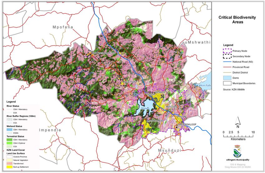
13.2 Environmental Priority Areas
(i) The original Environmental Priority Areas assessment that served as one of
the basic informants in the formulation of the uMngeni SDF, was updated
as more information became available. The MinSet and Cplan data sets
from Ezemvelo KZN Wildlife were used to create the map.
(ii) On review of the MinSet and Cplan maps, it became obvious that almost
all of the land within the uMngeni Municipality falls within Non Negotiable
Reserve (MinSet) or Category 1 (Cplan) – absolutely critical. Normally one
would overlay MinSet and Cplan data with land use information to produce
environmental priority areas.
(iii) As such, the Priority Map (see Map 4a) was produced by finding the
intersection between the land use data and the important species data. It
was felt that this would be the most practical way to identify areas of
environmental priority.
Priority 1: This category represent areas within the Municipality that have
been identified by EKZNW as important species, ecosystems or landscapes;
and which are natural ecosystems as per the land use data for the
Municipality such as grasslands or indigenous forests. These areas are
therefore untransformed and of high biodiversity importance.
Priority 2: These areas represent natural ecosystems as above but which
have not been identified by EKZNW as areas of important species,
ecosystems or landscapes. They therefore are not of biodiversity
importance, but do play a role in the functional importance of biodiversity
and ecosystem goods and services. These areas are therefore still
important, specifically in uMngeni, in terms of water production.
Priority 3: These areas are those that were identified by EKZNW as of
importance but which are transformed i.e. cultivated. These areas could
possibly be rehabilitated, but in terms of land use management cannot be
regarded as high priority areas.
(iv) Similarly to the agricultural production potential assessment, the
identification of environmental priority areas was done at a broad scale.
Individual properties would require more detailed environmental
assessments if a change of land use is contemplated. It is envisaged that
the priority areas will be reviewed once the SEA has been completed.
(v) The District SEA preparation has highlighted the fact that EKZNW has again
updated its approach to environmental mapping and is using “Critical
Biodiversity Areas” and “Ecological Support Areas”. These are terrestrial and
aquatic based. The District SEA envisages modifying these to take
Agricultural Land and Built up Settlement Areas into account.
(vi) Key Definitions as given in the EKZNW Draft Document of Conservation
Planning Terms dated 17 January 2012 are summarized as follows:You can also read