SUPERFUND EPA Should Take Additional Actions to Manage Risks from Climate Change - Report to Congressional Requesters
←
→
Page content transcription
If your browser does not render page correctly, please read the page content below
United States Government Accountability Office
               Report to Congressional Requesters

               SUPERFUND
October 2019

               EPA Should Take
               Additional Actions to
               Manage Risks from
               Climate Change

GAO-20-73
October 2019

                                                SUPERFUND
                                                EPA Should Take Additional Actions to Manage Risks
                                                from Climate Change
Highlights of GAO-20-73, a report to
congressional requesters

Why GAO Did This Study                          What GAO Found
Administered by EPA, Superfund is the           Available federal data—from the Environmental Protection Agency (EPA),
principal federal program for addressing        Federal Emergency Management Agency, National Oceanic and Atmospheric
sites containing hazardous substances.          Administration, and U.S. Forest Service—on flooding, storm surge, wildfires, and
EPA lists some of the most seriously            sea level rise suggest that about 60 percent of all nonfederal National Priorities
contaminated sites—most of which are            List (NPL) sites are located in areas that may be impacted by these potential
nonfederal—on the NPL and has                   climate change effects. Additional information on these sites can be viewed in an
recorded over 500 contaminants,                 interactive map and downloadable data file, available here (see figure).
including arsenic and lead, at those
sites. Climate change may make some             Nonfederal NPL Sites Located in Areas that May Be Impacted by Flooding, Storm Surge,
natural disasters more frequent or more         Wildfires, or Sea Level Rise
intense, which may damage NPL sites
and potentially release contaminants,
according to the Fourth National Climate
Assessment.
GAO was asked to review issues related
to the impact of climate change on
nonfederal NPL sites. This report
examines, among other objectives, (1)
what available federal data suggest
about the number of nonfederal NPL
sites that are located in areas that may
be impacted by selected climate change
effects and (2) the extent to which EPA
has managed risks to human health and
the environment from the potential
impacts of climate change effects at
such sites. GAO analyzed available
federal data; reviewed laws, regulations,
and documents; interviewed federal
officials and stakeholders; visited three
nonfederal NPL sites that experienced           Notes: This map does not display all 1,571 active and deleted nonfederal NPL sites GAO analyzed,
natural disasters; and compared EPA             which also include six sites in American Samoa, the Federated States of Micronesia, Guam, the
actions to manage risk to GAO’s six             Northern Mariana Islands, and the U.S. Virgin Islands, though they are included in the counts above.
essential elements of enterprise risk           Additional information on all sites GAO analyzed can be viewed at https://www.gao.gov/products/GAO-
                                                20-73. Storm surge data are not available for Alaska and Pacific islands other than Hawaii, wildfire
management.                                     data are not available outside the contiguous United States, and sea level rise data are not available
                                                for Alaska.
What GAO Recommends
                                                EPA’s actions to manage risks to human health and the environment from
GAO is making four recommendations              potential impacts of climate change effects at nonfederal NPL sites align with
to EPA, including that it clarify how its       three of the six essential elements of enterprise risk management GAO
actions to manage risks at nonfederal           previously identified, partially align with two essential elements, and do not align
NPL sites from potential impacts of             with one essential element. For example, EPA has not taken actions consistent
climate change align with current goals         with one essential element because it has not aligned its process for managing
and objectives. EPA agreed with one
                                                risks with agency-wide goals and objectives, which do not mention climate
recommendation and disagreed with the
                                                change. Without clarifying this alignment, EPA cannot ensure that senior officials
other three. GAO continues to believe
that all four are warranted.                    will take an active role in strategic planning and accountability for managing
                                                these risks.
View GAO-20-73. For more information, contact
Alfredo Gómez at (202) 512-3841 or
gomezj@gao.gov.
                                                ______________________________________ United States Government Accountability Office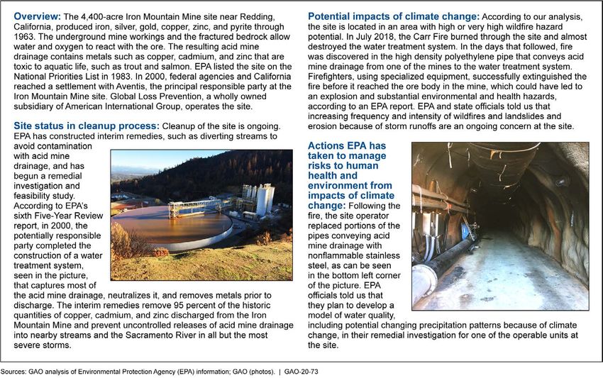
Contents

Letter                                                                                   1
               Background                                                                7
               About 60 Percent of Nonfederal NPL Sites Are Located in Areas
                 That May Be Impacted by Selected Climate Change Effects,
                 According to Available Data                                           18
               EPA Has Taken Some Actions to Manage Risks from the Potential
                 Impacts of Climate Change Effects at Nonfederal NPL Sites             34
               EPA Recognizes Various Challenges in Managing Risks from the
                 Potential Impacts of Climate Change Effects at Nonfederal NPL
                 Sites                                                                 45
               Conclusions                                                             48
               Recommendations for Executive Action                                    48
               Agency Comments and Our Evaluation                                      49

Appendix I     Objectives, Scope, and Methodology                                      54

Appendix II    Comments from the Environmental Protection Agency                       61

Appendix III   GAO Contact and Staff Acknowledgments                                   65

Table
               Table 1: Extent to Which EPA’s Actions to Manage Risks to
                       Human Health and the Environment from the Potential
                       Impacts of Climate Change Effects at Nonfederal National
                       Priorities List Sites Aligned with GAO’s Essential
                       Elements of Enterprise Risk Management                          34

Figures
               Figure 1: EPA’s 10 Regions                                                9
               Figure 2: EPA’s Remedial Cleanup Process at Nonfederal
                        National Priorities List Sites                                 10
               Figure 3: EPA’s Nonfederal NPL Sites in Areas That May Be
                        Impacted by Flooding, Storm Surge, Wildfire, or Sea
                        Level Rise                                                     19
               Figure 4: Nonfederal NPL Sites in EPA Region 7 Located in Areas
                        That May Be Impacted by Flooding                               22

               Page i                                GAO-20-73 Superfund and Climate Change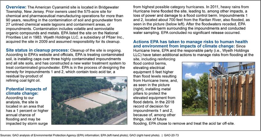
Figure 5: Nonfederal NPL Sites in EPA Regions 2 and 3 Located
         in Areas That May Be Impacted by Storm Surge                   24
Figure 6: American Cyanamid National Priorities List Site—New
         Jersey                                                         25
Figure 7: Nonfederal NPL Sites in EPA Region 9 Located in Areas
         with High or Very High Wildfire Hazard                         27
Figure 8: Iron Mountain Mine National Priorities List Site—
         California                                                     29
Figure 9: Nonfederal NPL Sites in EPA Region 6 Located in Areas
         That Would Be Inundated by Sea Level Rise                      31
Figure 10: San Jacinto River Waste Pits National Priorities List
         Site—Texas                                                     32

Page ii                               GAO-20-73 Superfund and Climate Change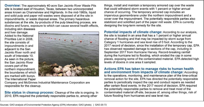
Abbreviations

CERCLA                              Comprehensive Environmental Response,
                                    Compensation, and Liability Act of 1980
EPA                                 Environmental Protection Agency
FEMA                                Federal Emergency Management Agency
National Contingency Plan           National Oil and Hazardous Substances
                                    Pollution Contingency Plan
NCA                                 Fourth National Climate Assessment
NOAA                                National Oceanic and Atmospheric
                                    Administration
NPL                                 National Priorities List
PRP                                 potentially responsible party
SLR                                 sea level rise

This is a work of the U.S. government and is not subject to copyright protection in the
United States. The published product may be reproduced and distributed in its entirety
without further permission from GAO. However, because this work may contain
copyrighted images or other material, permission from the copyright holder may be
necessary if you wish to reproduce this material separately.

Page iii                                         GAO-20-73 Superfund and Climate Change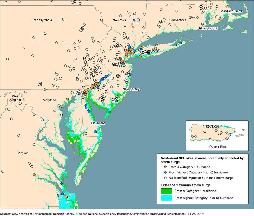
Letter

441 G St. N.W.
Washington, DC 20548

                       October 18, 2019

                       Congressional Requesters

                       In 2017, Hurricane Harvey dumped an unprecedented amount of rainfall
                       over the greater Houston area, damaging several Superfund sites that
                       contain hazardous substances. 1 At one site on the San Jacinto River in
                       Texas, floodwater eroded part of the structure containing such
                       substances, including dioxins, which are highly toxic and can cause
                       cancer and liver and nerve damage. 2 That same year, the Fourth National
                       Climate Assessment (NCA) stated that many temperature and
                       precipitation extremes have become more frequent, more intense, or
                       longer in duration. 3 The NCA reported that climate models are consistent
                       with these trends continuing, which may make certain natural disasters
                       more frequent or more intense. Further, the NCA reported that some
                       climate change effects, including sea level rise and increased coastal
                       flooding, could lead to the dispersal of pollutants, which could pose a risk
                       to public health.

                       The Superfund program—the federal government’s principal program to
                       address sites with hazardous substances—was established by the
                       Comprehensive Environmental Response, Compensation, and Liability
                       1
                        The Superfund process begins with the discovery of a potentially hazardous site or
                       notification to the Environmental Protection Agency (EPA) of the possible release of
                       hazardous substances, pollutants, or contaminants that may threaten human health or the
                       environment. EPA’s regional offices may discover potentially hazardous waste sites, or
                       such sites may come to EPA’s attention through reports from state agencies or citizens.
                       2
                        According to an EPA report on the effects of the 2017 hurricanes on Superfund sites, one
                       of several samples EPA took at the San Jacinto River Waste Pits site after Hurricane
                       Harvey showed high dioxin concentration, above 70,000 nanograms per kilogram, which
                       exceeds the site’s risk-based cleanup level of 30 nanograms per kilogram. However, EPA
                       officials told us that they were not able to access the site during the storm because of the
                       severe flooding, so they could not determine whether there was a release of the dioxin-
                       containing waste into the river at that time.
                       3
                        U.S. Global Change Research Program, Climate Science Special Report, Fourth
                       National Climate Assessment, Volume I (Washington, D.C.: 2017). Under the Global
                       Change Research Act of 1990, the Committee on Earth and Environmental Sciences of
                       the Federal Coordinating Council on Science, Engineering, and Technology is to
                       periodically prepare a scientific assessment, known as the NCA. Pub. L. No. 101-606, §
                       106, 104 Stat. 3096, 3101 (1990) (codified at 15 U.S.C. § 2936). The U.S. Global Change
                       Research Program coordinates and integrates the activities of 13 participating federal
                       departments and agencies that carry out research and support the nation’s response to
                       global change.

                       Page 1                                           GAO-20-73 Superfund and Climate Change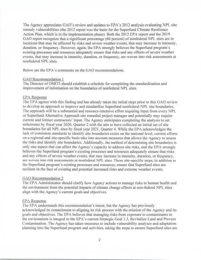
Act of 1980 (CERCLA). 4 EPA is responsible for administering the
program. EPA coordinates the cleanup of Superfund sites by identifying
sites potentially requiring cleanup action and placing eligible sites on its
National Priorities List (NPL), which includes some of the most seriously
contaminated sites. As of September 2019, there were 1,336 active sites
on the list, and 421 sites that EPA had determined need no further
cleanup action (deleted sites). About 90 percent of these active and
deleted NPL sites are nonfederal sites, where EPA generally carries out
or oversees the cleanup conducted by one or more potentially
responsible parties (PRP). 5 The other NPL sites—approximately 10
percent—are located at federal facilities, and the federal agencies that
administer those facilities are responsible for their cleanup. 6

CERCLA authorizes EPA to take various types of cleanup actions to
prevent human and environmental exposure to contamination from
nonfederal NPL sites, including remedial actions, which are long-term
cleanups. As part of the Superfund cleanup process, EPA identifies,
analyzes, and selects remedial actions that seek to protect human health
and the environment and meet site-specific remediation goals. In
September 2015, we found that annual EPA expenditures for remedial
actions at nonfederal NPL sites could be considerable—about $400
million for all such sites. 7 EPA is also required to conduct or oversee
reviews at least every 5 years at sites where remedial actions are
complete but contaminants remain, including at deleted sites, if
contaminants remaining on those sites exceed certain levels. Under

4
 Pub. L. No. 96-510, 94 Stat. 2767 (1980) (codified as amended at 42 U.S.C. §§ 9601-
9675).
5
 Under CERCLA, PRPs generally include current or former owners or operators of a site
and the generators and transporters of the hazardous substances. See 42 U.S.C. §
9607(a) (listing the types of parties liable for cleanup costs). In addition to EPA, other
entities can be the lead agencies for cleanups under CERCLA, such as state agencies;
this report focuses on sites for which EPA is the lead agency.
6
 Federal NPL sites are owned or operated by a department, agency, or instrumentality of
the United States, such as the Departments of Defense, Energy, and the Interior. The
agencies fund cleanup of federal NPL sites; this funding does not come from EPA’s
Superfund appropriation. Processes and provisions specific to these federal sites are
generally not discussed in this report, although they are subject to the same cleanup
requirements in CERCLA.
7
 GAO, Superfund: Trends in Federal Funding and Cleanup of EPA’s Nonfederal National
Priorities List Sites, GAO-15-812 (Washington, D.C.: Sept. 25, 2015). This funding was for
remedial cleanup activities, which include remedial investigations, feasibility studies, and
remedial action projects (actions taken to clean up a site).

Page 2                                            GAO-20-73 Superfund and Climate Change
EPA’s regulations, the agency may take additional remedial actions to
address releases at deleted sites if warranted under future conditions. 8

Climate change may impact Superfund sites in various ways. For
example, extreme precipitation events may impact Superfund sites that
have contaminated sediments in aquatic environments. Specifically, in a
2007 report, the National Research Council noted that buried
contaminated sediments at Superfund sites may be transported during
storms or other high-flow events, becoming a source of future exposure
and risk. 9 As a result of the significant risks posed by climate change and
the nation’s fiscal condition, in February 2013, we added Limiting the
Federal Government’s Fiscal Exposure by Better Managing Climate
Change Risks to our list of areas at high risk for fraud, waste, abuse, and
mismanagement, or most in need of transformation. 10 In March 2019, we
reported on progress to address this high-risk area. 11

You asked us to review issues related to the impact of climate change on
nonfederal NPL sites. This report examines (1) what available federal
data suggest about the number of nonfederal NPL sites that are located
in areas that may be impacted by selected climate change effects; (2) the
extent to which EPA has managed risks to human health and the
environment from the potential impacts of climate change effects at
nonfederal NPL sites; and (3) the challenges, if any, EPA faces in
managing these risks.

To determine what available federal data suggest about the number of
nonfederal NPL sites that are located in areas that may be impacted by
selected climate change effects, we reviewed the NCA and our prior work
on the Superfund program, climate change, and federal data on potential

8
40 C.F.R. § 300.425(e)(3).
9
 National Research Council, Sediment Dredging at Superfund Megasites: Assessing the
Effectiveness (Washington, D.C.: 2007). The National Research Council is the principal
operating agency of the National Academy of Sciences and the National Academy of
Engineering.
10
    GAO, High-Risk Series: An Update, GAO-13-283 (Washington, D.C.: Feb. 14, 2013).
11
  GAO, High-Risk Series: Substantial Efforts Needed to Achieve Greater Progress on
High-Risk Areas, GAO-19-157SP (Washington, D.C.: Mar. 6, 2019).

Page 3                                         GAO-20-73 Superfund and Climate Change
climate change effects. 12 We reviewed agency documents and
interviewed officials from agencies including EPA, the Federal Emergency
Management Agency (FEMA), the National Oceanic and Atmospheric
Administration (NOAA), and the U.S. Forest Service. Based on our review
of the NCA, we identified potential climate change effects and, based on
our review of EPA documents, determined which of these effects may
impact nonfederal NPL sites. 13 For these potential effects, we identified
available national-level federal data sets from FEMA, NOAA, and the U.S.
Forest Service on flooding, storm surge, and wildfires, respectively, which
are based on current or past conditions. The NCA reported that flooding,
storm surge, and wildfires will be exacerbated by climate change in some
parts of the country, but we did not identify federal data on the extent to
which these effects would vary from current or past conditions. We also
reviewed NOAA data on sea level rise, which provide information on the
geographic extent of inundation from potential sea level rise of up to 10
feet.

In presenting the results of our analysis, we refer to flooding, storm surge,
wildfires, and sea level rise as potential climate change effects. To the
extent that data were available, we analyzed a range of these potential
climate change effects. For example, we used the maximum extent of
storm surge from Category 1 hurricanes (the lowest possible category) as
well as Category 4 or 5 hurricanes (the highest possible categories), as
modeled by NOAA. 14 The full range of our results can be viewed in an
interactive graphic, which is available here. We focused on a range

12
  See, for example, Superfund Sediment Sites: EPA Considers Risk Management
Principles but Could Clarify Certain Procedures, GAO-16-777 (Washington, D.C.: Sept.
22, 2016); Climate Change: Better Management of Exposure to Potential Future Losses Is
Needed for Federal Flood and Crop Insurance, GAO-15-28 (Washington, D.C.: Oct. 29,
2014); and FEMA Flood Maps: Some Standards and Processes in Place to Promote Map
Accuracy and Outreach, but Opportunities Exist to Address Implementation Challenges,
GAO-11-17 (Washington, D.C.: Dec. 2, 2010).
13
  These potential climate change effects, which may vary across regions, include sea
level rise, which may lead to increased frequency and extent of extreme flooding from
coastal storms; greater frequency and magnitude of drought; increased intensity and
frequency of heavy precipitation events, which may lead to increased local flooding;
increased incidence of large wildfires; and increased intensity of hurricanes.
14
  NOAA rates hurricanes as Categories 1 through 5 on the Saffir-Simpson Hurricane Wind
Scale based on a hurricane’s sustained wind speed. Hurricanes reaching Category 3 and
higher are considered major hurricanes because of their potential for significant loss of life
and damage. Category 4 hurricanes are those that carry sustained winds of 130–156
miles per hour. Category 5 hurricanes are those with sustained winds exceeding 156
miles per hour.

Page 4                                            GAO-20-73 Superfund and Climate Change
because, for three of the four effects, we had data on current hazards,
which may become more intense and frequent in the future, according to
the NCA. Additionally, CERCLA directs EPA to give preference to
remedies that would result in the permanent and significant decrease in
toxicity, mobility, or volume of the contamination. According to EPA
officials, remedies at nonfederal NPL sites may have to be operational
indefinitely, during which time the potential effects of climate change may
become more extreme.

We obtained data from EPA’s Superfund Enterprise Management
System—EPA’s system of record for the Superfund program—on the
location and other characteristics of active and deleted nonfederal NPL
sites. 15 We analyzed these data using mapping software to identify
nonfederal NPL sites located in areas that may be impacted by selected
potential climate change effects. To do so, we determined whether there
are areas that may be impacted by flooding, storm surge, wildfires, and
sea level rise within a 0.2-mile radius of the primary geographic
coordinate of each nonfederal NPL site, 16 which we used to represent the
site boundaries. 17 We reviewed this analytical approach with EPA
officials. To assess the reliability of all of the data for our analysis, we,
among other things, assessed the timeliness and accuracy of the data
and related controls and found the data from EPA, FEMA, NOAA, and the
U.S. Forest Service to be sufficiently reliable for our purposes. (See app. I
for more detail on steps we took to assess the reliability of the data.)

To determine the extent to which EPA has managed risks to human
health and the environment from the potential impacts of climate change

15
  According to EPA officials, EPA makes data on the location of nonfederal NPL sites
available to the public strictly for informational purposes. Further, according to EPA
officials, these data are not intended for use in establishing liability or calculating cost
recovery statutes of limitations and cannot be relied upon to create any rights, substantive
or procedural, enforceable by any party in litigation with the United States or third parties.
EPA officials told us that EPA reserves the right to change these data at any time without
public notice.
16
  According to the Fiscal Year 2019 Superfund Program Implementation Manual, NPL
sites in the Superfund Enterprise Management System must have one primary coordinate,
which indicates the primary latitude and longitude coordinates for the site. This coordinate
must be located less than 1,000 meters from the site address.
17
  In a 2018 study, EPA used a 0.2-mile radius to approximate the size of NPL sites. In this
study, EPA noted that it used additional information to adjust this radius for some NPL
sites. We did not make such adjustments because doing so would have required site-
specific analysis, which was outside the scope of our review.

Page 5                                             GAO-20-73 Superfund and Climate Change
effects at nonfederal NPL sites, we examined relevant provisions in
CERCLA, EPA’s implementing regulations, executive orders, and EPA
documents on the cleanup of nonfederal NPL sites. We also reviewed
relevant documents, articles, studies, and other sources that we identified
by searching the websites of relevant agencies and organizations and
article databases, as well as through recommendations from officials and
stakeholders we interviewed. From our prior work, we identified six
essential elements of risk management that we reported could help
agencies anticipate and manage risk. 18

We compared EPA’s actions to manage risks to human health and the
environment from the potential impacts of climate change effects with
these essential elements of risk management. We analyzed information
on EPA actions by reviewing documents from EPA, the U.S. Global
Change Research Program, and the National Research Council and our
prior work on the Superfund program and climate change that we
identified during our search of documents, articles, and other sources. We
interviewed EPA officials at headquarters and all regional offices. We also
interviewed four stakeholders and representatives of two associations
with knowledge of the nexus between Superfund sites and climate
changes effects to obtain their views about the extent to which EPA has
managed these risks. We identified these stakeholders, such as a law
professor and state environmental officials, from our search of
documents, articles, and other sources and through referrals during
interviews.

In addition, we selected three nonfederal NPL sites from different EPA
regions to illustrate the extent to which EPA is managing these risks: the
American Cyanamid site in Bridgewater, New Jersey (Region 2); the Iron
Mountain Mine site near Redding, California (Region 9); and the San
Jacinto River Waste Pits site in Channelview, Texas (Region 6). We
selected these sites based on (1) EPA regional diversity, (2) variety in
potential climate change effects, and (3) whether they had been affected
by an extreme weather event within the last 10 years. The results from
these illustrative examples are not generalizable to nonfederal NPL sites
that we did not select. We toured each of these sites, reviewed relevant
documents, and interviewed EPA officials and site stakeholders, including

18
  GAO, Enterprise Risk Management: Selected Agencies’ Experiences Illustrate Good
Practices in Managing Risk, GAO-17-63 (Washington, D.C.: Dec. 1, 2016).

Page 6                                        GAO-20-73 Superfund and Climate Change
state and local officials, representatives of PRPs, and community
             organizations.

             To determine the challenges EPA faces in managing risks to human
             health and the environment from the potential impacts of climate change
             effects at nonfederal NPL sites, we reviewed documents from EPA and
             other relevant entities, including from the National Research Council,
             which we obtained from EPA officials and stakeholders or identified from
             our search of documents, articles, and other sources. We also
             interviewed EPA officials at headquarters and all regional offices and
             stakeholders. We grouped all challenges we identified into three
             categories for reporting purposes: institutional, resource, and technical
             challenges. Appendix I describes our objectives, scope, and methodology
             in more detail.

             We conducted this performance audit from April 2018 to October 2019 in
             accordance with generally accepted government auditing standards.
             Those standards require that we plan and perform the audit to obtain
             sufficient, appropriate evidence to provide a reasonable basis for our
             findings and conclusions based on our audit objectives. We believe that
             the evidence obtained provides a reasonable basis for our findings and
             conclusions based on our audit objectives.

             CERCLA established the Superfund program to clean up contaminated
Background   sites to protect human health and the environment from the effects of
             hazardous substances. CERCLA requires the President to establish
             procedures and standards for prioritizing and responding to releases of
             hazardous substances, pollutants, and contaminants into the environment
             and to incorporate these procedures and substances into the National Oil
             and Hazardous Substances Pollution Contingency Plan (National
             Contingency Plan). 19

             Under CERCLA, PRPs are liable for conducting or paying for the cleanup
             of hazardous substances at contaminated sites. EPA and PRPs can
             undertake two types of cleanup actions: removal actions and remedial
             actions. Removal actions are usually short-term cleanups for sites that

             19
               According to EPA, the National Contingency Plan is the federal government’s blueprint
             for responding to both oil spills and hazardous substance releases. The National
             Contingency Plan is the result of efforts to develop a national response capability and
             promote coordination among the hierarchy of responders and contingency plans.

             Page 7                                          GAO-20-73 Superfund and Climate Change
pose immediate threats to human health or the environment. Remedial actions are generally long-term cleanups—consisting of one or more remedial action projects—that aim to permanently and significantly reduce contamination. Remedial actions can take a considerable amount of time and money, depending on the nature of the contamination and other site-specific factors. EPA’s Office of Superfund Remediation and Technology Innovation, which is part of the Office of Land and Emergency Management, oversees remedial actions at NPL sites, including nonfederal NPL sites. 20 At each nonfederal NPL site, the lead official who is responsible for compliance with the National Contingency Plan is the remedial project manager. 21 Management of nonfederal NPL sites is the responsibility of the EPA region in which a site is located. EPA has 10 regional offices, and each one is responsible for executing EPA programs within several states and, in some regions, territories. Figure 1 illustrates EPA’s 10 regions. 20 According to EPA’s website, the Office of Land and Emergency Management provides policy, guidance, and direction for the agency’s emergency response and waste programs. The Office of Superfund Remediation and Technology Innovation administers the Superfund program and works to ensure that the hazardous waste sites on the NPL are cleaned up to protect human health and the environment. The Office of Land and Emergency Management was previously named the Office of Solid Waste and Emergency Response. 21 40 C.F.R. § 300.120(f)(1). Page 8 GAO-20-73 Superfund and Climate Change
Figure 1: EPA’s 10 Regions

                             Notes: EPA Region 2 also includes the U.S. Virgin Islands. EPA Region 9 also includes American
                             Samoa, the Federated States of Micronesia, Guam, the Northern Mariana Islands, the Republic of the
                             Marshall Islands, and the Republic of Palau.

                             The Superfund process begins with the discovery of a potentially
                             hazardous site or notifications to EPA regarding the possible release of
                             hazardous substances that may pose a threat to human health or the
                             environment. EPA’s Superfund remedial cleanup process for nonfederal
                             NPL sites includes the actions shown in figure 2.

                             Page 9                                               GAO-20-73 Superfund and Climate Change
Figure 2: EPA’s Remedial Cleanup Process at Nonfederal National Priorities List Sites
Note: EPA’s actions in the remedial cleanup process may overlap, and EPA may undertake multiple
actions concurrently at a site.
• Site assessment. EPA, states, tribes, or other federal agencies
evaluate site conditions to identify appropriate responses to releases
of hazardous substances to the environment. During this process,
EPA or other entities, such as state or tribal agencies, collect data to
identify, evaluate, and rank sites using agency criteria. 22
• Site listing. EPA considers whether to list a site on the NPL based on
a variety of factors, including the availability of alternative state or
federal programs that may be used to clean up the site. Sites that
EPA proposes to list on the NPL are published in the Federal
Register. After a period of public comment, EPA reviews the
comments and makes final decisions on whether to list the sites on
the NPL.
• Remedial investigation and feasibility study. EPA or the PRP will
generally begin the remedial cleanup process for an NPL site by
conducting a two-part study of the site. First, EPA or the PRP
conducts a remedial investigation to characterize site conditions and
assess the risks to human health and the environment, among other
22
EPA uses the Hazard Ranking System to guide decision-making and, as needed, to
numerically assess the site’s relative potential to pose a threat to human health or the
environment. Sites with a Hazard Ranking System score of 28.50 or greater are eligible
for listing on the NPL.
Page 10 GAO-20-73 Superfund and Climate Changeactions. 23 Second, EPA or the PRP conducts a feasibility study to
assess various alternatives to address the problems identified through
the remedial investigation. Under the National Contingency Plan, EPA
considers nine criteria, including long-term effectiveness and
permanence, in its assessment of alternative remedial actions. 24
• Record of decision. EPA issues a record of decision that identifies
its selected remedy for addressing the contamination at a site. A
record of decision typically lays out the planned cleanup activities for
each operable unit of the site as well as an estimate of the cost of the
cleanup. 25
• Remedial design and remedial action. EPA or the PRP plans to
implement the selected remedy during the remedial design phase,
and then, in the remedial action phase, EPA or the PRP carries out
one or more remedial action projects. 26
• Construction completion. EPA generally considers construction of
the remedial action to be complete for a site when all physical
construction at a site is complete, including actions to address all
immediate threats and to bring all long-term threats under control.
• Postconstruction completion. EPA, the state, or the PRP performs
operation and maintenance for the remedy, if needed, such as by
operating a groundwater extraction and treatment system. EPA
generally performs reviews of the remedy at least every 5 years to
23
As part of the remedial investigation, EPA is to identify applicable or relevant and
appropriate requirements for the site. These requirements may include cleanup standards
set by federal or state environmental laws that specifically address a contaminant,
remedial action, location, or other circumstance at an NPL site.
24
The nine evaluation criteria are (1) overall protection of human health and the
environment; (2) compliance with applicable or relevant and appropriate requirements; (3)
long-term effectiveness and permanence; (4) reduction of toxicity, mobility, or volume
through treatment; (5) short-term effectiveness; (6) implementability; (7) cost; (8) state
acceptance; and (9) community acceptance. 40 C.F.R. § 300.430(e)(9)(iii).
25
An operable unit is a discrete action that comprises an incremental step toward
comprehensively addressing site problems. 40 C.F.R. § 300.5. The cleanup of a site can
be divided into a number of operable units, depending on the complexity of the problems
associated with the site. Operable units may address geographical portions of a site,
specific site problems, or initial phases of an action, or may consist of any set of actions
performed over time or any actions that are concurrent but located in different parts of a
site.
26
In some cases, EPA will fund the cleanup, such as when EPA cannot identify a PRP.
Page 11 GAO-20-73 Superfund and Climate Changeevaluate whether it continues to protect human health and the
environment. 27
• Deletion from the NPL. EPA may delete a site, or part of a site, from
the NPL when the agency and the relevant state authority determine
that no further site response is needed. 28
Contaminants and Nonfederal NPL sites may include a variety of contaminants, and EPA
Remedies at Nonfederal may select different types of remedies to clean up the sites. EPA had
recorded more than 500 contaminants at nonfederal NPL sites as of fiscal
NPL Sites
year 2014, the most recently available data. According to the Agency for
Toxic Substances and Disease Registry, the highest-priority
contaminants—based on a combination of their prevalence, toxicity, and
potential for human exposure—are arsenic, lead, mercury, vinyl chloride,
and polychlorinated biphenyls. 29 For example, in 2016, the Agency for
Toxic Substances and Disease Registry reported that exposure to arsenic
in drinking water is associated with various health effects, such as
pulmonary and cardiovascular disease, diabetes, and certain cancers. 30
Contaminants may be found in different media at nonfederal NPL sites. In
2017, EPA reported that groundwater and soil were the most common
contaminated media, including at the nonfederal NPL sites it analyzed. 31
27
EPA is to review Superfund remedial actions at least every 5 years where hazardous
substances, pollutants, or contaminants will remain on-site above levels that allow for
unlimited use and unrestricted exposure. EPA is also to report to Congress the list of sites
for which these reviews are required, the results of such reviews, and any actions taken
as a result of the reviews. 42 U.S.C. § 9621(c).
28
EPA is to conduct Five-Year Reviews at deleted sites if the level of contamination at the
sites exceeds what would permit unlimited use and unrestricted exposure. 40 C.F.R. §
300.430(f)(4)(ii).
29
Under CERCLA, the Agency for Toxic Substances and Disease Registry and EPA are to
prepare, in order of priority, a list of substances that are most commonly found at NPL
sites and revise it periodically. The Agency for Toxic Substances and Disease Registry’s
most recent update to the substance priority list was in 2017. We accessed the list on April
24, 2019, at https://www.atsdr.cdc.gov/spl/.
30
Agency for Toxic Substances and Disease Registry, Addendum to the Toxicological
Profile for Arsenic (Atlanta, Ga.: February 2016).
31
Environmental Protection Agency, Office of Land and Emergency Management,
Superfund Remedy Report, 15th Edition (July 2017). In this report, EPA analyzed
Superfund sites, including 1,508 nonfederal NPL sites, that had signed decision
documents—records of decision, amendments to records of decision, and explanations of
significant differences. EPA also conducted more detailed analyses of decision documents
signed in fiscal year 2012 through fiscal year 2014.
Page 12 GAO-20-73 Superfund and Climate ChangeTo clean up a nonfederal NPL site, EPA may select various on-site or off-
site remedies. For example, EPA may select on-site remedies that
include treatment as well as those that do not, such as on-site
containment, monitored natural recovery, and institutional controls. 32 In
2017, EPA reported that about a quarter of the decision documents for
sites it analyzed included on-site treatment. EPA may also treat or
dispose the contamination off-site. Examples of off-site treatment and
disposal include incineration and recycling. EPA reported that sites it
analyzed may have various combinations of remedies, including
treatment, on-site containment, off-site disposal, and institutional controls.
Available Federal Data on Various federal agencies provide nationwide data on flooding, storm
Flooding, Storm Surge, surge from hurricanes, wildfires, and sea level rise. Data on flooding,
storm surge, and wildfires are generally based on current or past
Wildfires, and Sea Level
conditions. NOAA models the extent of inundation for various heights of
Rise sea level rise compared to the most recently available data on average
high tide.
Flooding FEMA provides flood hazard and risk information to communities
nationwide. Among other information, FEMA provides data on coastal and
riverine flooding in the National Flood Hazard Layer, 33 a database that
contains the most current flood hazard data. 34 Federal law requires FEMA
to assess the need to revise and update the nation’s flood maps at least
every 5 years. 35 Among other uses, the flood hazard data are used for
flood insurance ratings and floodplain management. The National Flood
Hazard Layer identifies areas at the highest risk of flooding, which are
32
Institutional controls include administrative and legal controls that minimize the potential
for human exposure, for example, by limiting land use or providing information to guide
behavior at the site, such as through zoning restrictions. Institutional controls are a subset
of land use control, which can include physical measures such as fencing.
33
Riverine flooding is flooding related to or caused by a river, stream, or tributary
overflowing its banks because of excessive rainfall, snowmelt, or ice.
34
FEMA provides a tool for viewing, downloading, and printing flood maps for specific
locations. We accessed the tool on August 8, 2019, at https://www.fema.gov/national-
flood-hazard-layer-nfhl.
35
42 U.S.C. § 4101(e).
Page 13 GAO-20-73 Superfund and Climate Changethose that have a 1 percent or higher annual chance of flooding. 36 In
some locations, the National Flood Hazard Layer also identifies areas
with 0.2 percent or higher annual chance of flooding, which FEMA
considers to be a moderate flood hazard, 37 as well as other flood hazards.
The National Flood Hazard Layer also identifies areas with minimal flood
hazard, including those with less than 0.2 percent annual chance of
flooding, and unknown flood hazard, including areas FEMA had not
assessed for flood hazards. 38 In 2018, the Technical Mapping Advisory
Council noted that FEMA has produced modernized data (i.e., digital
maps) for areas of the United States where 98 percent of the population
resides, but has not determined the flood hazard for 40 percent of
streams. 39 In general, flood hazards are based on existing conditions in
the watershed and floodplains. However, in certain cases, FEMA may
include flood hazard information that is based on future conditions,
according to FEMA regulations. 40
Storm Surge NOAA provides estimates of hurricane storm surge using a model called
Sea, Lake and Overland Surges from Hurricanes. 41 Estimates are
36
These areas are known as Special Flood Hazard Areas. Under federal law, in
communities that participate in the National Flood Insurance Program, homeowners are
required to purchase flood insurance for properties located in Special Flood Hazard Areas
that are secured by mortgages from federally regulated lenders. 42 U.S.C. § 4012a(b)(1).
37
According to the NCA, the magnitude and intensity of riverine flooding is projected to
increase in the future, so areas with moderate flood hazard may have increased flood
hazards in the future.
38
We also considered areas where flood data are not available in a form compatible with
our mapping software, such as those only available in paper maps, as unknown flood
hazard. Paper-based maps can provide information on flood hazards to other users, such
as communities and owners of Superfund sites, according to FEMA officials.
39
The Technical Mapping Advisory Council is a federal advisory committee established to
review and make recommendations to FEMA on matters related to the national flood
mapping program.
40
Future conditions refer to the flood discharges that would occur if current zoning or
comprehensive land use plans were realized. See 44 C.F.R. § 59.1. For example, as
planned buildings and parking lots are constructed, the amount of impervious land within
the watershed increases, which can increase the amount of direct runoff. In our analysis,
we categorized these areas as other flood hazards.
41
According to a NOAA document, storm surge is an abnormal rise of water generated by
a storm, over and above the predicted tides. Storm surge is produced by water being
pushed toward the shore by the force of the winds. NOAA’s storm surge hazard maps,
accessed on December 31, 2018, are available at
https://www.nhc.noaa.gov/nationalsurge/.
Page 14 GAO-20-73 Superfund and Climate Changeavailable for eastern U.S. coastal areas from Texas through Maine and
other areas affected by storm surge, including Hawaii, Puerto Rico, and
the U.S. Virgin Islands. As of June 2019, NOAA had not modeled storm
surge for the West Coast of the United States or other Pacific islands.
The model takes into account a specific locale’s shoreline, incorporating
bay and river configurations, water depths, bridges, roads, levees, and
other physical features. It estimates the maximum extent of storm surge
at high tide by modeling hypothetical hurricanes under different storm
conditions, such as landfall location, storm trajectory, and forward speed.
NOAA models storm surge from Category 1 through Category 5
hurricanes for the Atlantic coast south of the North Carolina–Virginia
border, the Gulf of Mexico, Puerto Rico, and the U.S. Virgin Islands and
Category 1 through Category 4 hurricanes for the Atlantic coast north of
the North Carolina–Virginia border and Hawaii. 42 According to NOAA’s
website, the model is to be used for educational purposes and awareness
of the storm surge hazard at a city or community level. In accordance with
federal law, the model is also used for other purposes, such as hurricane
evacuation studies. 43 According to NOAA’s website, the agency updates
the model for portions of the shoreline each year to account for, among
other changes, new data and the addition of flood protection devices,
such as levees. The model does not account for future conditions such as
erosion, subsidence (i.e., the sinking of an area of land), construction, or
sea level rise.
Wildfires The U.S. Forest Service maps wildfire hazard potential based on
landscape conditions and other observations. 44 According to the U.S.
Forest Service, the primary intended use of the wildfire hazard potential
map is to identify priority areas for hazardous fuels treatments from a
broad, national- to regional-scale perspective. The U.S. Forest Service
maps an index of wildfire hazard potential for the contiguous United
42
According to a NOAA official, NOAA does not estimate storm surge for Category 5
hurricanes in areas where such hurricanes have not historically made landfall, such as
areas north of the North Carolina–Virginia border.
43
6 U.S.C. § 721.
44
According to the U.S. Forest Service, the objective of the wildfire hazard potential map is
to depict the relative potential for wildfire that would be difficult for suppression resources
to contain. For the 2018 map, the U.S. Forest Service used spatial data sets of wildfire
likelihood and intensity from 2016, spatial fuels and vegetation data from 2012, and point
locations of past fire occurrence from 1992 to 2013. The U.S. Forest Service’s wildfire
hazard potential map, accessed on May 3, 2019, is at
https://www.firelab.org/project/wildfire-hazard-potential.
Page 15 GAO-20-73 Superfund and Climate ChangeStates, based on, among other factors, annual burn probabilities and
potential intensity of large fires. The U.S. Forest Service categorizes the
wildfire hazard potential index into five classes of very low, low, moderate,
high, and very high. For example, the U.S. Forest Service designates as
“high” those areas with wildfire hazard potential index from the 85th to the
95th percentile, and “very high” above the 95th percentile. The U.S.
Forest Service also categorizes areas as nonburnable (including
agricultural and developed lands) and water. According to the U.S. Forest
Service, areas with higher values of wildfire hazard potential represent
vegetation that is more likely to burn with high intensity under certain
weather conditions. However, areas with moderate, low, and very low
wildfire hazard potential may still experience wildfire, particularly if they
are near areas that have higher wildfire hazard potential. Wildfire hazard
potential is not a forecast or wildfire outlook for any particular season as it
does not include any information on current or forecasted weather or fuel
moisture conditions. 45
Sea Level Rise NOAA models the extent of inundations from various heights of sea level
rise (up to 10 feet above average high tides) for the contiguous United
States, Hawaii, the Pacific islands, Puerto Rico, and the U.S. Virgin
Islands and provides the results in a web mapping tool called the Sea
Level Rise Viewer. 46 NOAA’s guidance on the Sea Level Rise Viewer
states that data are not available for Alaska. The uses of the sea level
rise data include planning and education but not site-specific analysis,
according to a NOAA document. NOAA labels areas as not mapped if
elevation data of sufficient quality for the areas are not available. NOAA
does not model natural processes, such as erosion, subsidence, or future
construction, or forecast how much sea level is likely to rise in a given
area. Rather, for various heights of local sea level rise, NOAA determines
extent of inundation based on the elevation of an area and the potential
for water to flow between areas.
Enterprise Risk Enterprise risk management is a tool that allows agencies to assess
Management threats and opportunities that could affect the achievement of their goals.
In a December 2016 report, we updated our 2005 risk management
45
According to a U.S. Forest Service official, the wildfire hazard potential data are not
meant to substitute for local data that may more accurately capture the potential for
wildfire in particular areas.
46
NOAA’s Sea Level Rise Viewer, accessed on August 7, 2019, is at
https://coast.noaa.gov/digitalcoast/tools/slr.html.
Page 16 GAO-20-73 Superfund and Climate Changeframework to reflect changes to the Office of Management and Budget’s Circular A-123, 47 which calls for agencies to implement enterprise risk management. 48 We also incorporated recent federal experience and identified essential elements of federal enterprise risk management. 49 Our December 2016 report states that beyond traditional internal controls, enterprise risk management promotes risk management by considering the effect of risk across the entire organization and how it may interact with other identified risks. Additionally, it addresses other topics, such as strategy determination, governance, communicating with stakeholders, and measuring performance. The principles of enterprise risk management apply at all levels of the organization and across all functions, such as those related to managing risk to human health and the environment from the potential impacts of climate change effects at nonfederal NPL sites. The six essential elements of enterprise risk management that we identified in our December 2016 report are as follows: 1. Align risk management process with goals and objectives. Ensure that the process maximizes the achievement of agency mission and results. Agency leaders examine strategic objectives by regularly considering how risks could affect the agency’s ability to achieve its mission. 2. Identify risks. Assemble a comprehensive list of risks—both threats and opportunities—that could affect the agency’s ability to achieve its goals and objectives. 3. Assess risks. Examine risks, considering both the likelihood of the risk and the impact of the risk to help prioritize risk response. 47 We developed our 2005 risk management framework in the context of risks associated with homeland security and combating terrorism. However, increased attention to enterprise risk management concepts and their applicability to all federal agencies and missions led us to revise our risk framework to incorporate enterprise risk management concepts. These concepts can help leaders better address uncertainties in the federal environment, including changing and more complex operating environments based on technology changes and other global factors and stakeholders seeking greater transparency and accountability. 48 Office of Management and Budget, Management’s Responsibility for Enterprise Risk Management and Internal Control, OMB Circular No. A-123 (July 15, 2016). 49 GAO-17-63. See also GAO, Risk Management: Further Refinements Needed to Assess Risks and Prioritize Protective Measures at Ports and Other Critical Infrastructure, GAO-06-91 (Washington, D.C.: Dec. 15, 2005). Page 17 GAO-20-73 Superfund and Climate Change
4. Respond to the risks. Select risk treatment response (based on risk
                               appetite), including acceptance, avoidance, reduction, sharing, or
                               transfer.
                            5. Monitor risks. Monitor how risks are changing and whether
                               responses are successful.
                            6. Communicate and report on risks. Communicate risks with
                               stakeholders and report on the status of addressing the risks.

                            Available federal data on flooding, storm surge, wildfires, and sea level
About 60 Percent of         rise suggest that about 60 percent (945 of 1,571) of all nonfederal NPL
Nonfederal NPL Sites        sites are located in areas that may be impacted by one or more of these
                            potential climate change effects. These data, however, may not fully
Are Located in Areas        account for the number of nonfederal NPL sites that may be in such areas
That May Be                 because (1) federal data are generally based on current or past
                            conditions; (2) data are not available for some areas; and (3) the NCA
Impacted by Selected        has reported that climate change may exacerbate flooding, storm surge,
Climate Change              and wildfires in certain regions of the United States. In addition, EPA does
                            not have quality information on the boundaries of nonfederal NPL sites,
Effects, According to       which could affect its ability to identify the number of sites that may be
Available Data              impacted by one or more of these potential climate change effects.

About 60 Percent of         Available federal data suggest that 945 of 1,571 nonfederal NPL sites, or
Nonfederal NPL Sites Are    about 60 percent, are located in areas that may be impacted by selected
                            climate change effects—that is, 0.2 percent or higher annual chance of
Located in Areas That May
                            flooding or other flood hazards, storm surge from Category 4 or 5
Be Impacted by Selected     hurricanes, high and very high wildfire hazard potential, and sea level rise
Climate Change Effects;     of up to 3 feet. The locations of these sites are shown in figure 3; the full
Additional Sites May Be     results of our analysis and additional information on these sites is
Impacted in the Future      available in the interactive map and downloadable data file, which can be
                            viewed at https://www.gao.gov/products/GAO-20-73.

                            Page 18                                  GAO-20-73 Superfund and Climate Change
Figure 3: EPA’s Nonfederal NPL Sites in Areas That May Be Impacted by Flooding, Storm Surge, Wildfire, or Sea Level Rise
Notes: We represented the boundaries of nonfederal National Priorities List (NPL) sites with a 0.2-
mile radius around the primary geographic coordinate of each site. Depending on the actual site
boundaries, the results of our analysis may not accurately reflect the number of nonfederal NPL sites
located in these areas. This map does not display all 1,571 active and deleted nonfederal NPL sites
we analyzed, which also include six sites in American Samoa, the Federated States of Micronesia,
Guam, the Northern Mariana Islands, and the U.S. Virgin Islands, although we include them in the
counts above. The full results of our analysis, which include additional information about these sites,
are available in the interactive map and downloadable data file, which can be viewed at
https://www.gao.gov/products/GAO-20-73. This analysis is based on the most recently available data
from EPA, FEMA, NOAA, and the U.S. Forest Service as of March 2019.
Page 19 GAO-20-73 Superfund and Climate Changea
In our analysis, we use “coastal hazard” to refer to nonfederal NPL sites in areas that may be
impacted by storm surge from Category 4 or 5 hurricanes and sea level rise of up to 3 feet. They may
also be impacted by 0.2 percent or higher annual chance of flooding or other flood hazards.
According to NOAA, storm surge data are not available for the West Coast of the United States,
Alaska, and Pacific islands other than Hawaii and sea level rise data are not available for Alaska.
b
In our analysis, we use “flood hazard” to refer to nonfederal NPL sites in areas that FEMA has
determined have a 0.2 percent or higher annual chance of flooding or other flood hazards.
c
In our analysis, we use “wildfire hazard” to refer to nonfederal NPL sites in areas with high or very
high wildfire hazard potential. According to the U.S. Forest Service, wildfire hazard potential data are
not available outside the contiguous United States.
d
In our analysis, we use “no identified impacts” to refer to nonfederal NPL sites in areas with no or
unknown hazard levels, including where data were unavailable. For example, FEMA flood data are
not available for all locations in a format we could analyze.
Our analysis, however, may not fully account for the number of
nonfederal NPL sites that may be impacted by the effects of climate
change for various reasons. First, we represented the areas of nonfederal
NPL sites based on a 0.2-mile radius around their primary geographic
coordinates, which may not accurately reflect their area (i.e., they may be
larger or smaller). We did not analyze site-specific information for these
nonfederal NPL sites, including the extent of contamination and location
of remedies. Such site-specific analyses would be needed to determine
whether there is a risk to human health and the environment at
nonfederal NPL sites as a result of these potential climate change effects.
Further, according to the NCA, EPA documents, and interviews with EPA
officials, there may be other climate change effects that could impact
nonfederal NPL sites, such as potential increases in salt water intrusion
(the movement of saline water into freshwater aquifers), drought,
precipitation, hurricane winds, and average and extreme temperatures;
we did not analyze these effects because we did not identify relevant
national-level federal data sets.
Flooding We identified 783 nonfederal NPL sites—approximately 50 percent—in
areas that FEMA had identified as having 0.2 percent or higher annual
chance of flooding, which FEMA considers moderate flood hazard, or
other flood hazards, as of October 2018. 50 Of these 783 sites, our
analysis shows that 713—approximately 45 percent of all sites—are
currently located in areas with 1 percent or higher annual chance of
50
Other flood hazards include areas with reduced risk because of levees as well as areas
with flood hazard based on future conditions, for example, if land use plans were
implemented. FEMA considers areas with at least 0.2 percent annual chance of flooding
as having moderate flood hazard and those with 1 percent or higher annual chance of
flooding to be Special Flood Hazard Areas (i.e., those with the highest chance of flooding).
Page 20 GAO-20-73 Superfund and Climate Changeflooding, FEMA’s highest flood hazard category. We provide information on the number of sites in areas with moderate or other flood hazards because, according to the NCA, heavy rainfall is increasing in intensity and frequency across the United States and is expected to continue to increase, which may lead to an increase in flooding in the future. The full results of our analysis—which include information on the sites in areas that may have 1 percent or higher annual chance of flooding, 0.2 percent or higher annual chance of flooding or other identified flood hazards, unknown flood hazard or no data, and minimal flood hazard—are available in our interactive map, which can be viewed here. For example, there are a number of nonfederal NPL sites in EPA Region 7, where states experienced record flooding in early 2019. Specifically, as seen in figure 4, there are 51 sites that are located in areas with 0.2 percent or higher annual chance of flooding or other identified flood hazards, of which 42 are located in areas with 1 percent or higher annual chance of flooding. Page 21 GAO-20-73 Superfund and Climate Change
You can also read