JPA1.2 SIMISTER/BOWLEE TOPIC PAPER PFE 2021 - GREATER ...
←
→
Page content transcription
If your browser does not render page correctly, please read the page content below
JPA1.2 Simister/Bowlee

     Topic Paper

      PfE 2021
Contents
Section A – Background ............................................................................................................... 4
1.0 Introduction ..................................................................................................................... 4
2.0 Simister/Bowlee Allocation Overview .............................................................................. 6
3.0 Site Details ..................................................................................................................... 7
4.0 Proposed Development .................................................................................................. 7
5.0 Site Selection.................................................................................................................. 8
6.0 Planning History ........................................................................................................... 11
7.0 GMSF 2019 Consultation Responses ........................................................................... 11
8.0 GMSF 2019 Integrated Assessment ............................................................................. 12
9.0 GMSF 2020 Integrated Assessment ............................................................................. 14
10.0 PfE 2021 Integrated Appraisal Addendum ....................... Error! Bookmark not defined.
Section B – Physical ................................................................................................................... 16
11.0 Transport ...................................................................................................................... 16
12.0 Flood Risk and Drainage .............................................................................................. 19
13.0 Ground Conditions ........................................................................................................ 21
14.0 Utilities .......................................................................................................................... 24
Section C – Environmental.......................................................................................................... 27
15.0 Green Belt Assessment ................................................................................................ 27
16.0 Green Infrastructure ...................................................................................................... 31
17.0 Recreation .................................................................................................................... 32
18.0 Landscape .................................................................................................................... 32
19.0 Ecological/Biodiversity Assessment .............................................................................. 36
20.0 Habitat Regulation Assessment .................................................................................... 39
21.0 Historic Environment Assessment ................................................................................ 39
22.0 Air Quality ..................................................................................................................... 43
Site Allocation Topic Paper – JPA1.2 Simister/Bowlee - PfE 2021
223.0 Noise ............................................................................................................................ 43
Section D – Social ...................................................................................................................... 46
24.0 Education ..................................................................................................................... 46
25.0 Health ........................................................................................................................... 46
Section E – Deliverability ............................................................................................................ 47
26.0 Viability ......................................................................................................................... 47
27.0 Phasing ........................................................................................................................ 48
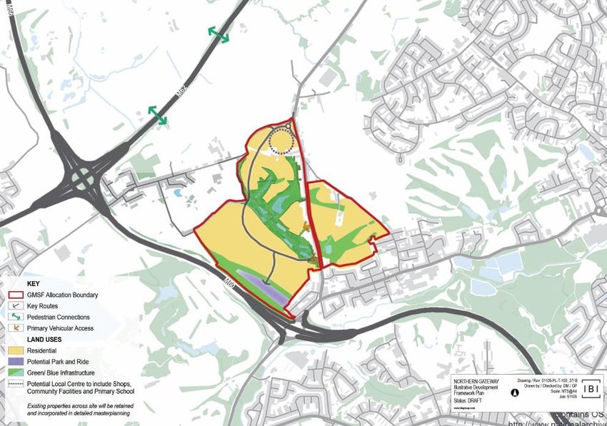
28.0 Indicative Masterplanning ............................................................................................. 49
Section F – Conclusion ............................................................................................................... 52
29.0 The Integrated Appraisal............................................................................................... 52
30.0 The main changes to the Proposed Allocation .............................................................. 52
31.0 Conclusion .................................................................................................................... 54
Section G – Appendices ............................................................................................................. 56
Section H – Bibliography ............................................................................................................. 71
Site Allocation Topic Paper – JPA1.2 Simister/Bowlee - PfE 2021
3Section A – Background
1.0 Introduction
1.1 In November 2014, the AGMA Executive Board recommended to the 10 Greater
Manchester local authorities that they agree to prepare a joint Development Plan
Document (“Joint DPD”), called the Greater Manchester Spatial Framework
(“GMSF”) and that AGMA be appointed by the 10 authorities to prepare the GMSF
on their behalf.
1.2 The first draft of the GMSF DPD was published for consultation on 31st October
2016, ending on 16th January 2017. Following substantial re-drafting, a further
consultation on the Revised Draft GMSF took place between January and March
2019.
1.3 On the 30 October 2020 the AGMA Executive Board unanimously agreed to
recommend GMSF 2020 to the 10 Greater Manchester Councils for approval for
consultation at their Executives/Cabinets, and approval for submission to the
Secretary of State following the period for representations at their Council meetings.
1.4 At its Council meeting on 3 December Stockport Council resolved not to submit the
GMSF 2020 following the consultation period and at its Cabinet meeting on 4
December, it resolved not to publish the GMSF 2020 for consultation.
1.5 As a joint DPD of the 10 Greater Manchester authorities, the GMSF 2020 required
the approval of all 10 local authorities to proceed. The decisions of Stockport
Council/Cabinet therefore signalled the end of the GMSF as a joint plan of the 10.
1.6 Notwithstanding the decision of Stockport Council, the nine remaining districts
considered that the rationale for the preparation of a Joint DPD remained.
Consequently, at its meeting on the 11th of December 2020, Members of the AGMA
Executive Committee agreed in principle to producing a joint DPD of the nine
remaining Greater Manchester (GM) districts. Subsequent to this meeting, each
Site Allocation Topic Paper – JPA1.2 Simister/Bowlee - PfE 2021
4district formally approved the establishment of a Joint Committee for the preparation
of a joint Development Plan Document of the nine districts.
1.7 Section 28 of the Planning and Compulsory Purchase Act 2004 and Regulation 32 of
the Town and Country Planning (Local Planning) (England) Regulations 2012 enable
a joint plan to continue to progress in the event of one of the local authorities
withdrawing, provided that the plan has ‘substantially the same effect’ on the
remaining authorities as the original joint plan. The joint plan of the nine GM districts
has been prepared on this basis.
1.8 In view of this, it follows that PfE should be considered as, in effect, the same Plan
as the GMSF, albeit without one of the districts (Stockport). Therefore “the plan” and
its proposals are in effect one and the same. Its content has changed over time
through the iterative process of plan making, but its purpose has not. Consequently,
the Plan is proceeding directly to Publication stage under Regulation 19 of the Town
and Country Planning (Local Planning) England Regulations 2012.
1.9 Four consultations took place in relation to the GMSF. The first, in November 2014
was on the scope of the plan and the initial evidence base, the second in November
2015, was on the vision, strategy and strategic growth options, and the third, on a
Draft Plan in October 2016.
1.10 The fourth and most recent consultation on The Greater Manchester Plan for
Homes, Jobs and the Environment: the Greater Manchester Spatial Framework
Revised Draft 2019 (GMSF 2019) took place in 2019. It received over 17,000
responses. The responses received informed the production of GMSF 2020. The
withdrawal of Stockport Council in December 2020 prevented GMSF 2020
proceeding to Regulation 19 Publication stage and instead work was undertaken to
prepare PfE 2021.
1.11 Where a local planning authority withdraws from a joint plan and that plan continues
to have substantially the same effect as the original joint plan on the remaining
authorities, s28(7) of the Planning and Compulsory Purchase Act 2004 provides that
any step taken in relation to the plan must be treated as a step taken by the
remaining authorities for the purposes of the joint plan. On this basis, it is proposed
Site Allocation Topic Paper – JPA1.2 Simister/Bowlee - PfE 2021
5to proceed directly to Publication stage under Regulation 19 of the Town and
Country Planning (Local Planning) England Regulations 2012.
1.12 A comprehensive evidence base was assembled to support the policies and
proposals in the GMSF 2020. Given the basis on which the Plan has been prepared,
this evidence base remains the fundamental basis for the PfE 2021and has
remained available on the GMCA’s website since October 2020. That said, this
evidence base has been reviewed and updated in the light of the change from GMSF
2020 to the PfE2021 and, where appropriate, addendum reports have been
produced and should be read in conjunction with evidence base made available in
October 2020. The evidence documents which have informed the plan are available
via the GMCA’s website.
2.0 Simister/Bowlee Allocation Overview
2.1 The Northern Gateway is an extensive area located around Junction 18 of the M60
motorway extending east to Junction 19 of the M62 and north to Junction 3 of the
M66. It comprises two interrelated allocations at:
• Heywood / Pilsworth (Bury and Rochdale)
• Simister and Bowlee (Bury and Rochdale)
2.2 Development of the area will deliver a large, nationally significant employment led
opportunity to attract high quality business and investment which is supported by
new housing that is well integrated with, and brings positive benefits to, the
surrounding communities.
2.3 This Topic Paper brings together a wide range of information and evidence in
connection with the proposed strategic site allocation at Simister/Bowlee (JPA1.2).
However, it should be read in conjunction with the separate Topic Paper relating to
the Heywood/Pilsworth (GMA1.1). The paper may be subject to further technical
amendments in advance of the formal commencement of consultation.
Site Allocation Topic Paper – JPA1.2 Simister/Bowlee - PfE 2021
62.4 The extent of the Simister/Bowlee allocation has been reduced significantly in the
PfE 2021 compared to what was proposed in the 2019 draft. Some of the evidence
gathered for the allocation relates to the extent of the allocation proposed in 2019.
Nevertheless, given that the allocation has subsequently been reduced, it is
considered reasonable to conclude that the changes made between then and the
current version of the plan will not have caused any additional issues.
3.0 Site Details
3.1 The proposed site allocation at Simister/Bowlee (JPA1.2) is located between the
settlements of Prestwich and Middleton and covers a total area of 74 hectares. The
majority of its western boundary borders on the M60, the southern boundary abuts
the edge of the village of Rhodes and the allocation’s eastern boundary wraps
around the western and northern edges of Middleton.
3.2 The allocation currently comprises agricultural land and a number of residential,
employment and agricultural properties.
4.0 Proposed Development
4.1 Approximately 1,550 homes are proposed within the Simister/Bowlee allocation.
Around 1,350 homes will be in Bury and a further 200 will be located in Rochdale.
4.2 This will include the provision of affordable housing to address local housing need,
accommodation for older persons, plots for custom and self-build. It will also include
a mix of housing densities with higher density development in areas with good
accessibility and with potential for improved public transport connectivity and lower
densities adjacent to existing villages where development will require sensitive
design to respond to its context.
4.3 The proposed development will be required to provide infrastructure to support the
new community. This includes an upgrade of the local highway network, traffic
restrictions on Simister Lane to prevent this route from being a form of access/egress
to and from the allocation, improved public transport provision through the allocation
and close to the allocation, more routes for walking and cycling, a new local centre
Site Allocation Topic Paper – JPA1.2 Simister/Bowlee - PfE 2021
7with an appropriate range of convenience shopping facilities and a primary school.
There will be high quality, publicly accessible, multifunctional green and blue
infrastructure throughout the allocation which can be used for sport, leisure and
recreation.
4.4 The proposed site allocation at Simister/Bowlee has now been reduced in size since
the 2019 Draft GMSF with the total site allocation reducing from 206 ha to 74 ha.
Land to the north of Blueball Lane, together with a small area on the south western
edge, are to be excluded from the Allocation and retained in the Green Belt. The
area around Simister Village, will also now be excluded from the Allocation and
retained as Green Belt. These reductions were in response work undertaken in
preparation of the 2020 GMSF which highlighted that there was scope to reduce
Bury’s housing requirements leading to a reduction in the amount of land required to
be removed from the greenbelt and to calls from local residents to preserve the
character of Simister Village. In addition, there is significantly less certainty over the
development of a new motorway junction at Birch which would have been a major
access point into the allocation.
5.0 Site Selection
5.1 The Site Selection work had the purpose of identifying the most sustainable locations
for residential and employment development that can achieve the Joint Plan’s Vision,
Objectives and Spatial Strategy.
5.2 This allocation forms part of the wider Northern Gateway allocation and straddles the
districts of Bury and Rochdale. The Northern Gateway, in its entirety, provides the
opportunity to deliver a large nationally significant employment opportunity which can
attract high quality business and investment and provide complementary residential
development.
5.3 The allocation is positioned at a strategically important intersection around the M60,
M62 and M66 motorways. As such, it represents a highly accessible opportunity for
growth in Greater Manchester, with wider benefits on a regional and national level.
Site Allocation Topic Paper – JPA1.2 Simister/Bowlee - PfE 2021
85.4 Due to the current undeveloped nature of the allocation, much of the immediate
highway network is not of a nature that could accommodate strategic development
without an appropriate upgrade. Key to the delivery of the allocation will be the
provision of significant improvements to highway infrastructure, delivery of improved
public transport infrastructure through the allocation (including Bus Rapid Transport
corridor) and close to the allocation and the provision of high quality walking and
cycling routes.
5.5 The scale of the development will help to deliver a significant jobs boost to the
northern and eastern parts of Greater Manchester, increasing the economic output
from this area. It will also enable new residential and community facilities to come
forward in what is currently an area with significant pockets of deprivation, low skills
and worklessness.
5.6 The site selection process considered the entire Northern Gateway allocation when
considering sites for inclusion in the GMSF. On this basis the allocation was selected
for inclusion based on:
• Criteria 1 (land which has been previously developed and/or land which is
served by public transport);
• Criteria 3 (land that can maximise existing opportunities which have significant
capacity to deliver transformational change and/or boost the competitiveness
and connectivity of Greater Manchester and genuinely deliver inclusive
growth);
• Criteria 5 (land which would have a direct significant impact on delivering
urban regeneration);
• Criteria 6 (land where transport investment (by the developer) and the
creation of significant new demand (through appropriate development
densities), would support the delivery of long term viable sustainable travel
options and delivers significant wider community benefits);
Site Allocation Topic Paper – JPA1.2 Simister/Bowlee - PfE 2021
9• Criteria 7 (Land that would deliver significant local benefits by addressing a
major local problem/issue).
5.7 Further detail is provided within in the Site Selection Background Paper available at
https://www.greatermanchester-ca.gov.uk/placesforeveryone. A 2021 addendum to
the background paper has been produced which confirms that as the allocation has
not changed since 2020, the conclusions from the GMSF Site Selection Topic Paper
2020 remain applicable.
5.8 Specifically, the Simister/Bowlee allocation forms part of the PfE North East Growth
Corridor Policy (JP-Strat 7) and offers an opportunity to deliver a significant mixed
use, housing and employment development which is of a transformative scale and
significantly change the economic growth potential of the wider area. Development
could capitalise on the existing successful employment locations at Heywood and
Pilsworth and further exploit the important connection to the M62 corridor. The
location of this allocation will make it particularly attractive to the logistics and
advanced manufacturing sectors.
5.9 Development could also contribute towards regeneration of adjacent areas of
deprivation and this would help deliver one the PfE’s key aims of boosting the
competitiveness of the northern Greater Manchester Boroughs and supporting long-
term economic growth in Greater Manchester.
5.10 Given the above, the allocation is relevant to the PfE objectives of:
• Objective 1 – Meet our housing need;
• Objective 3 – Playing our part in ensuring a thriving and productive economy
in all parts of Greater Manchester;
• Objective 4 – Maximise the potential arising from our national and
international assets;
• Objective 5 – Reduce inequalities and improve prosperity;
Site Allocation Topic Paper – JPA1.2 Simister/Bowlee - PfE 2021
10• Objective 6 – Promote the sustainable movement of people, goods and
information.
6.0 Planning History
6.1 Planning permission has not been granted for any significant uses within the
allocation.
7.0 GMSF 2019 Consultation Responses
7.1 399 comments were received in relation to JPA1.2 Simister/Bowlee during the
consultation on the Revised Draft GMSF in 2019. A summary of the key issues are
as follows:
Table 1 Summary of Consultation Responses from the Revised Draft GMSF in
2019
Principle / scale of development
▪ Unreasonable and disproportionate scale of development in one location.
▪ Will cause considerable harm to character of small village, result in a loss of
amenity and depress property values. Compulsory purchase will be required.
▪ Some landowners wish to see the site extended.
▪ Support, provided that villages sympathetically merged and appropriate
separation distances implemented.
Housing (inc affordable housing)
▪ Layout not sympathetic to village which will be overwhelmed.
▪ Scale of growth proposed not achievable and will take a number of years to
come forward. Phasing will be critical to avoid flooding the market.
▪ Does not cater for affordable/specialist housing needs. Needs to be
environmentally friendly and delivered at appropriate densities.
▪ Housing growth should be distributed more evenly across Bury.
▪ There is support that the development will provide much needed housing in
this location, there is a willingness from landowners in Simister to bring the site
forward and more housing to south of village should be considered.
Employment and Economy
▪ No need for employment proposal at Heywood/Pilsworth as low
unemployment and deprivation in Simister and Bowlee. Likely to be low paid,
need quality manufacturing, no indication of interest.
▪ Residents will have poor access and will need to commute out.
Site Allocation Topic Paper – JPA1.2 Simister/Bowlee - PfE 2021
11▪ Support – Must invest in the Northern Powerhouse.
Green Belt
▪ Simister will lose all of its Green Belt, this was misrepresented in the
consultation letter. Wide disparities between Bury townships.
▪ Area is semi-rural and remote, designation attracts people to area.
▪ No justification, will result in sprawl and merge distinct towns.
▪ Details on proposed protections for removals not made clear.
▪ It was highlighted that Clarkes Cross (west of M60) has been omitted but could
still make a contribution in the form of safeguarded land for long-term needs
8.0 GMSF 2019 Integrated Assessment
8.1 The 2019 GMSF Integrated Assessment (IA) is available at
https://www.greatermanchester-ca.gov.uk/placesforeveryone.
8.2 The IA reviewed how the draft GMSF policies could impact upon the environment,
the economy, local communities, equality and public health. The IA also
recommended ways in which the GMSF can be improved to ensure that the policies
are as sustainable as possible.
8.3 The three Northern Gateway draft allocations were considered together against the
2019 Integrated Assessment objectives. The allocations performed well however a
number of recommendations were made:
• Ensure that all three allocations refer to a mix of housing types;
• Make specific reference to energy efficiency of the housing stock;
• The policy should also highlight the importance of local employment during
construction;
• Consider feasibility study into requirements and ability of local network to
support development;
Site Allocation Topic Paper – JPA1.2 Simister/Bowlee - PfE 2021
12• Benefits such as creation of construction and operational employment, or
improved transport links or increases in the range of community facilities,
should consider deprived areas. Where possible such benefits should be
maximised to help bring about long term benefits for deprived areas;
• The allocation needs to encourage integration with existing communities and
provision of a range of housing tenures;
• Ensure any new health provision is accessible to all and that local capacity is
considered throughout future masterplanning stages;
• Ensure any new community facilities provision is accessible to all and that
local capacity is considered throughout future masterplanning stages;
• Ensure any new recreation provision is accessible to all and that local
capacity is considered throughout future masterplanning stages;
• Seek to minimise the number of trips made by private car to/from the site.
Consider the use of mitigation solutions including green infrastructure,
incentivising electric vehicles and/or masterplan layout which reduces
emissions near sensitive receptors. This is especially relevant to buffer around
the AQMA adjacent to the site;
• A suitable flood risk assessment may be required and associated mitigation in
order to prevent the flood zone expanding;
• Appropriate flood risk mitigation should be implemented (in line with best
practice) for all developments that are within or near to areas of flood risk.
This is especially relevant around the areas of flood zone 2 and 3;
• Make reference to energy efficiency directly and ways that it can be
increased, such as highlighting the benefits of sustainable modes of transport;
• Consider the listed structures throughout detailed design to reduce the risk
throughout construction and operational phases;
Site Allocation Topic Paper – JPA1.2 Simister/Bowlee - PfE 2021
13• Consider how development of PDL sites could be encouraged as a result of
greenfield development (e.g. by incentives or inclusion of adjacent PDL);
• Promote sustainable construction methods; and
• Consider waste and recycling facilities in design e.g. consider location of
waste/recycling facilities in design/layout of masterplans, and how waste
facilities can be located to encourage recycling.
8.4 It is important to note that the IA was focusing on each policy in isolation from other
policies and that many of the recommended changes for the Northern Gateway
allocation policies are already covered in other GMSF policies. However, some
wording changes have been made as a result of the IA in relation to housing types,
electric vehicles, heritage and archaeology.
9.0 GMSF 2020 Integrated Assessment
9.1 An Integrated Appraisal (IA) was undertaken on the 2020 draft GMSF in order to
understand how the policy had changed since the 2019 IA and to identify if any
further enhancement/mitigation were required. The 2020 GMSF Integrated
Assessment (IA) is available at https://www.greatermanchester-
ca.gov.uk/placesforeveryone.
9.2 The majority of the 2019 recommendations for the Simister and Bowlee allocation
had been positively addressed by the 2020 allocation policy itself or other GMSF
thematic policies. However the 2020 IA did recommend a further three changes in
order to further strengthen the policies:
• Climate Change - since the 2019 IA was undertaken there has been greater
emphasis on the climate change agenda and this is reflective of the
declaration of a climate emergency by the ten GM authorities;
• Accessible design standards – whilst this was broadly covered in Policy GM-
E1 and within GM-H3 relating to housing, it was suggested that policies were
strengthened with more specific reference to accessible design of buildings
Site Allocation Topic Paper – JPA1.2 Simister/Bowlee - PfE 2021
14and spaces to meet the needs of users. This could be achieved through
strengthening Policy GM-E1.
• Deprivation - whilst this was also broadly covered within the supporting text
within Policy GM-E1, particularly referencing social inclusivity, it was
considered that the policy could be more explicit in terms of inclusive growth
and making jobs available to existing local communities or to those suffering
deprivation.
9.3 These recommendations were incorporated into the final 2020 GMSF.
10.0 PfE 2021 Integrated Appraisal Addendum
10.1 A 2021 PfE Integrated Appraisal Addendum has been produced and has reviewed
the changes made between GMSF 2020 and PfE 2021. As there have been no
substantial changes to this specific allocation between GMSF 2020 and PfE 2021
and the 2020 IA recommendations which had been incorporated into the GMSF
2020 remain in the PfE Policy, there has been no change to the assessment of this
Policy in relation to the IA Framework since 2020.
Site Allocation Topic Paper – JPA1.2 Simister/Bowlee - PfE 2021
15Section B – Physical
11.0 Transport
11.1 The allocation is divided into two parts; a larger part to the west of the A6045 and a
smaller part to the east. The allocation is located to the south-east of the Simister
Island interchange, north-west of Middleton, and is bound by the M60 to the west,
the M62 to the north and the A576/A6045 to the east and south. The delivery of this
allocation will require significant investment in infrastructure. In particular the
allocation will need to deliver a wide range of public transport improvements in order
to promote sustainable travel and improve linkages to new employment opportunities
at the Heywood/Pilsworth allocation (GMA1.1).
11.2 The Locality Assessment 2020 available at https://www.greatermanchester-
ca.gov.uk/placesforeveryone concludes that that this development, both in isolation
and in consideration of the cumulative impacts with other nearby GMSF allocations,
is expected to materially impact both the strategic and local road networks. The
Strategic Road Network (SRN) impacts are expected to be concentrated at M60
Junction 19 and M62 Junction 19, whilst the Local Road Network (LRN) impacts
mostly impact the junctions on the A6045 Heywood Old Road.
11.3 As part of the Locality Assessment process, a number of mitigation schemes were
developed and tested to address identified network congestion points over both the
strategic and local road networks. These schemes have been developed in outline
detail to inform viability and allocations policy. Further detailed work will be
necessary to identify the specific interventions required to ensure the network works
effectively based on transport network conditions at the time of the planning
application/s and to take into account the effects of material future changes to the
network such as M60 J18 Simister Island improvements and the proposed Middleton
Metrolink extension which could significantly impact on travel trends in the immediate
locality.
11.4 During the Locality Assessment process, the M60 Junction 19 / A576 Middleton
Road junction proved particularly problematic in terms of providing a realistic
representation in the local junction modelling. Furthermore detailed modelling of the
roundabout and adjoining parts of the network – potentially using traffic simulation
tools – is recommended at this location. Furthermore detailed work is alsorecommended at the M62 Junction 19 roundabout to better define the required
mitigation.
11.5 The following mitigation measures have been identified:
Table 2. Allocation Access mitigation measures
Mitigation Description
Two new 3-arm signalised junctions Allocation access for the land parcel
with A6045. west of A6045.
Two new 3-arm priority junctions with Allocation access for the land parcel
A6045. east of A6045.
Table 3 Supporting Strategic Interventions identified
Mitigation Description
New Metrolink Stop on the proposed New stop on the proposed Crumpsall to
line between Crumpsall and Middleton. Middleton line near Rhodes.
Bus Rapid Transit (BRT) corridor to Bus Rapid Transit (BRT) corridor to
Manchester city centre. Manchester city centre and Heywood
via Heywood Old Road/ Manchester
Road.
Table 4 Necessary Local Mitigations identified
Mitigation Description
Permeable network for pedestrian and Assumed new or upgraded cycle and
cyclist priority to/from/ within the pedestrian access, linked to PROWs
development. and the Bee Network, providing
connectivity to adjacent local areas and
employment/educational opportunities,
supported by high quality design for
active travel within the allocation area.
Introduction of local bus services Assumed local bus services to link the
to/from/within the allocation. allocation with Metrolink and Rail
interchanges and key local centres
such as Prestwich and Middleton,
supported by permeable design of
future development to support bus
services within the allocation area.
Improvement of A6045 Heywood Old Required improvements not yet known;
Road / A576 traffic signal junction. subject to further study.
Site Allocation Topic Paper – JPA1.2 Simister/Bowlee - PfE 2021
17A6045 Heywood Old Road/Langley Signalisation of the junction. This
Lane. scheme is already identified by
Rochdale Council in support of other
local committed development.
Table 5 SRN interventions identified
Mitigation Description
M60 Junction 19/A576 Middleton Road. Signalisation of the Northern and
Eastern Arms (A576 N and the M60
West Bound off Slip).
M62 J19/A6046 Heywood Interchange. Consideration of alternative
pedestrian/cycle configurations and re-
optimization of the signal timings.
Possible corridor improvements on Required improvements not yet known;
A576 Middleton Road / Manchester Old subject to further study.
Road in vicinity of M60 J19.
2021 Locality Assessment Review
11.6 As a result of the withdrawal of Stockport Council and their associated allocations
from the GMSF, the Locality Assessments have been reviewed. The Northern
Gateway Locality Assessment Update Note (2021) confirms that the conclusions of
the GM1.2 Simister and Bowlee, November 2020 remain robust.
11.7 The 2020 assessment gave an initial indication that the traffic impacts of the
allocation can be sufficiently mitigated, and that the allocation is deliverable with the
proposed mitigation in place.
11.8 These conclusions have been tested again, using updated modelling where
necessary, to reflect recent changes – such as Stockport’s withdrawal from GMSF
and the implementation of the Simister Island Improvements (see Northern Gateway
LA Update Report, 2021 at https://www.greatermanchester-
ca.gov.uk/placesforeveryone).
11.9 The review has not identified any significant changes and, on this basis, the
conclusions arrived at in the 2020 Locality Assessment are considered to still be
valid.
Site Allocation Topic Paper – JPA1.2 Simister/Bowlee - PfE 2021
1811.10 However, significant further work is recommended to verify and refine the findings of
the Locality Assessment, particularly in relation to connections to the SRN, as the
allocation moves through the planning process. The allocation would also need to be
supported by continuing wider transport investment across GM.
12.0 Flood Risk and Drainage
Flood Risk Summary
12.1 The majority of the allocation is located within Flood Zone 1 (i.e. land assessed as
having a lower than 1 in 1000 annual probability of river flooding) and development
should be directed into these areas, if possible. There are no main rivers within the
boundary of the allocation.
12.2 There is localised risk of groundwater flooding at and below ground level across the
northern part of the allocation and adjacent to an unmarked watercourse which flows
southerly through the allocation to the south of Simister Lane. Detailed future
designs for the development will be able to take into account the overland flow
routes and any groundwater flood risk and potential areas of ponding to ensure there
is no increase to flood risk within the allocation or elsewhere as a result of the
development.
12.3 The allocation is at low risk of sewer flooding.
GMSF Greater Manchester Level 1 Strategic Flood Risk Assessment
12.4 The Greater Manchester Level 1 Strategic Flood Risk Assessment (GM Level 1
SFRA) was completed in March 2019 available at https://www.greatermanchester-
ca.gov.uk/placesforeveryone as part of the evidence base to inform the preparation
of the GMSF. This SFRA initiated the sequential risk-based approach to the
allocation of land for development and identified whether application of the Exception
Test was likely to be necessary using the most up-to-date information and guidance.
12.5 The Level 1 SFRA assessed the 2019 draft allocation boundary for JPA1.2 and
concluded that as 98% of the allocation is located within Flood Zone 1, the flood risk
Site Allocation Topic Paper – JPA1.2 Simister/Bowlee - PfE 2021
19within the JPA1.2 allocation could be avoided through site layout and design as part
of a detailed flood risk assessment. All of the smaller GMSF 2020 boundary is
located within Flood Zone 1.
12.6 Building on the conclusions of the Level 1 SFRA, the site promoters for JPA1.2
Simister/Bowlee have prepared a JPA1.2 Flood Risk and Drainage High Level
Constraints Review to assess the risk of flooding in more detail and consider what
mitigation measures may be required.
12.7 To ensure that flood risk is not increased at the allocation or elsewhere as a result of
the development, surface water runoff from the development will be restricted to the
existing greenfield runoff rate.
12.8 The JPA1.2 Flood Risk and Drainage High Level Constraints Review states that the
proposed drainage system will include a variety of SuDS features providing
green/blue spaces (such as detention basins and swales). These shall address both
flooding and water quality issues and be designed to mimic natural drainage features
within the allocation and provide recreational areas for the public. Alternate SuDS
options such as wetlands, provide an opportunity to maximise biodiversity and
maximise public open space and will be considered. Infiltration may be possible
across some of the allocation subject to detailed ground investigations on a localised
basis. Parts of the allocation have been identified as historic landfill sites. It is
considered unlikely that infiltration of surface water is likely only to be an
environmentally safe option if remediation has been carried out in advance to a
standard specifically to suit infiltration.
12.9 No public surface water sewers have been identified within the allocation. Surface
water run-off will be discharged into the ground through multiple infiltration structures
or to the watercourses within the allocation at the limiting discharge rates. This will
require discussion and agreement with the Environment Agency and the Lead Local
Flood Authority.
12.10 The JPA1.2 Flood Risk and Drainage High Level Constraints Review states that the
masterplan for the allocation is being developed with due consideration for the
existing topography, watercourses and rivers and development plots are likely to be
Site Allocation Topic Paper – JPA1.2 Simister/Bowlee - PfE 2021
20located with substantial offsets from these features. This provides the opportunity to
create green/blue corridors adjacent to the existing watercourses and will not require
the diversion of any watercourses and culverted works will be kept to a minimum.
12.11 The proposed policy wording for the JPA1.2 seeks to ensure that any development
within the allocation is safe from and mitigates for potential flood risk from all
sources. Policy JPA1.2 requires development to incorporate sustainable drainage
systems to manage surface water and control the rate of surface water run-off,
discharging in accordance with the hierarchy of drainage options. Proposals to
discharge to public sewer will need to submit clear evidence demonstrating why
alternative options are not available. As a green and blue infrastructure network will
provide more sustainable options discharge surface water, only foul flows should
communicate with the public sewer.
12.12 The allocation is therefore considered to be deliverable although further work will be
needed as the allocation moves through the planning process.
13.0 Ground Conditions
Site Geology and Hydrogeology
13.1 The Desk Top Assessment has identified:
• Made ground – expected to be present where landfilling has occurred, where
quarries, sand & gravel pits have been backfilled, around man-made features
and around buildings where ground has been disturbed by construction
activities;
• Superficial deposits – Predominantly glacial morainic deposits are present
overlain by head deposits along water courses and by glacial fluvial deposits
locally in the south;
• Bedrock - Coal Measures in the north western three quarters of the allocation.
The Chester Formation (sandstone) is present in south western quarter of the
allocation. These geological formations are separated by the Bradley Fold
Site Allocation Topic Paper – JPA1.2 Simister/Bowlee - PfE 2021
21Fault trending north west to south east. The allocation is not located in a high
risk development area in relation to Coal Mining activities.
Ground Contamination
13.2 The allocation predominantly comprises agricultural land which is not expected to be
significantly contaminated.
13.3 The potential risks from and mitigation for contamination in these areas are given in
the table below.
13.4 Intrusive ground investigation will be undertaken to establish if any contamination is
present and, if it is, to establish its nature and extent. An initial characterisation
investigation will enable an outline remediation strategy for the allocation to be
developed. More detailed investigation, assessment and detailed remediation design
can then be undertaken on a phase by phase basis as each area of the allocation
comes forward for development.
Table 6 Geo-environmental Aspects and Mitigation
Area of Potential Contamination Risk Potential Mitigation
Contamination
Backfilled quarries/pits Backfill material unknown. Assessment of material
and landfills May contain and remediation and,
contamination especially where possible, re-use of
asbestos. material.
Ground gas Migration from landfilling Ground gas protection
activities and generation measures may be
from the peat. required in new build
properties.
Shallow groundwater Potential for Consideration of
contamination of shallow contamination if shallow
groundwater. groundwater present in
any contaminated parts of
the site.
Geotechnical Summary
Site Allocation Topic Paper – JPA1.2 Simister/Bowlee - PfE 2021
2213.5 Geotechnical aspects to consider within the allocation include compressible peat
deposits, backfilled quarries and pits and groundwater presence. The ground will
also need to be characterised for cut and fill works and for foundation design. The
geotechnical aspects are given in the table below along with potential mitigation
measures. Intrusive investigation will be undertaken to assess these aspects further.
Table 7 Geo-technical Aspects and Mitigation
Geotechnical Aspect Geotechnical risk Potential mitigation
Backfilled quarries / pits Backfill material unknown. Identification and intrusive
Risk of unacceptable investigation of backfill.
settlements / collapse Geotechnical assessment
especially if loaded. and re-engineering of
material as required.
Slopes Existing slopes and new Investigation and
slopes – risk of instability / assessment of existing
slope failures. slopes. Reprofiling or
remediation if required.
Geotechnical design of
new slopes / appropriate
retaining structures.
Shallow groundwater Groundwater in Temporary support /
excavations. Risks of pumping during works if
instability from required.
groundwater ingress.
13.6 The Assessment has been reviewed by Bury Council Environmental Health
department. They have recommended the following prior to any planning
applications being submitted within the allocation:
• Ground investigation to determine the potential for ground gas, contaminated
soil and leachate associated with the infilling of former quarries / pits and
historical and registered landfills (both on and off site); and,
• Ground investigation to assess the likelihood of ground contamination
associated with the pollution incidents (specifically chemically driven
incidents).
13.7 The documents are available at https://www.greatermanchester-
ca.gov.uk/placesforeveryone.
Site Allocation Topic Paper – JPA1.2 Simister/Bowlee - PfE 2021
2313.8 The allocation is therefore considered to be deliverable although further work will be
needed as the allocation moves through the planning process.
14.0 Utilities
14.1 It is not considered that there are any utilities constraints, either current infrastructure
or identified need, which will prevent the Northern Gateway allocations from being
allocated for development.
United Utilities
14.2 United Utilities have provided guidance to pre-development enquires and advised
that the anticipated point of connection for the development will be the nearest
practical point on the network to the development boundary. This is identified as
315mm PE main is located on the southern side of the M62 and it is the nearest
suitable main.
14.3 No public foul sewers were identified within the development boundary, therefore
foul water is likely to need to be pumped to a new or existing point of discharge
specified by United Utilities, outside of the development boundary. Consultations
must be made with United Utilities to develop a cost-effective strategy for managing
the discharge of foul flows from the development.
Electricity North West
14.4 Electricity North West in their response to the latest GMSF consultation advised that
they were confident in being able to meet the network capacity requirements for the
investment and growth in proposed in Greater Manchester. Where necessary they
have secured the appropriate regulatory allowances within their ‘Well Justified
Business Plan.’
14.5 Electricity North West have carried out assessments on the proposed areas, which
fed into the GMCA ‘Spatial Energy Plan’ document. This is a high level assessment
of the expected impact of the proposed developments on the electricity network, the
information was presented as a Red/Amber/Green (RAG) indicator.
Site Allocation Topic Paper – JPA1.2 Simister/Bowlee - PfE 2021
2414.6 The Simister/Bowlee allocation presented as green which indicates no primary
substation capacity issue envisaged due to forecast additional load resulting from
proposed development.
14.7 Discussions with ENW have identified a requirement for 2 new primary 33KV
substations and a Point of Connection at Agecroft BSP. From the new 33KV Primary
Substations a further network of 11KV substations will be provided that distribute
demand across the allocation.
14.8 Overhead electricity cable pylons are also present on the southern section of the
allocation. These and their appropriate easements will need to be accommodated in
the masterplan, albeit given the location in the southern-most edge of the allocation
ENW has advised this does not present a major constraint.
Gas - National Grid Infrastructure
14.9 Cadent Gas have confirmed that the current mains have sufficient capacity to
support the load required for the development without any reinforcement works. The
development can be connected to the existing Medium Pressure main located
approximately 800 metres from the development boundary. Appropriate gas
governors located along the route through the allocation within the proposed road
network will also be required.
Telecommunications
Existing BT Infrastructure
14.10 The scheme already tabled and being implemented through the South Heywood
Development scheme to provide BT Openreach communication network coverage is
being developed to facilitate the Northern Gateway Proposals to both the Northern
and Southern areas of the allocation. BT Openreach are presently developing their
network layout and will be installing high speed data & fibre networks throughout the
development.
Existing Virgin Media Infrastructure
Site Allocation Topic Paper – JPA1.2 Simister/Bowlee - PfE 2021
2514.11 The scheme already tabled and being implemented through the South Heywood
Development scheme to provide Virgin Media communication network coverage will
be developed to facilitate the Northern Gateway Proposals to both the Northern and
Southern areas of the allocation. Virgin Media are presently developing their network
layout for this area and will be a suitable alternative network provider.
Site Allocation Topic Paper – JPA1.2 Simister/Bowlee - PfE 2021
26Section C – Environmental
15.0 Green Belt Assessment
15.1 The proposed removal of the Simister/Bowlee allocation from the Green Belt has
been informed by several studies undertaken by LUC available at available at
https://www.greatermanchester-ca.gov.uk/placesforeveryone including:
• The Greater Manchester Green Belt Assessment 2016;
• Green Belt Harm Assessment, 2020; and
• Greater Manchester Green Belt Study – Identification of Opportunities, 2020.
• Assessment of Proposed 2021 PfE Plan Allocations, 2021
15.2 The proposed allocation would involve the release of approximately 74 hectares of
land from the Green Belt in Bury.
15.3 In 2016 GMCA commissioned LUC to undertake an assessment of the Green Belt
within GM. The Study assessed the extent to which the land within the GM Green
Belt performs against the purposes of Green Belts, as set out in paragraph 80 of the
National Planning Policy Framework (NPPF). The aim of this Green Belt Assessment
is to provide the GM Authorities with an objective, evidence-based and independent
assessment of how GM’s Green Belt contributes to the five purposes of Green Belt,
as set out in national policy. It also examines the case for including within the Green
Belt potential additional areas of land that currently lie outside it.
15.4 In The Greater Manchester Green Belt Assessment 2016 Simister/Bowlee was
included within Strategic Green Belt Area 15. There were 4 different purposes of
Green Belt that each Area was assessed against and the Area performs as follows:
Table 8. Assessment of site against purposes of Green Belt
Purpose Performance of area
Site Allocation Topic Paper – JPA1.2 Simister/Bowlee - PfE 2021
27To check the unrestricted sprawl of Strong
large built up areas
To prevent neighbouring towns from Strong
merging into one another
To assist in safeguarding the Weak-Moderate
countryside from encroachment
Preserving the setting and special Weak-Moderate
character of historic towns
15.5 The summary of findings for Bury in this report stated that most parcels close to
Simister/Bowlee, make a moderate - strong contribution to checking the unrestricted
sprawl of large built up areas. Parcels between Bury and Middleton play a moderate
role in relation to assisting in safeguarding the countryside from encroachment.
15.6 In 2019 LUC carried out an assessment identifying the potential opportunities to
enhance the beneficial use of remaining Green Belt within 2 km of the allocation site.
The study considered the opportunities to offset the loss of Green Belt through
compensatory improvements to the environmental quality and accessibility of the
remaining Green Belt land.
15.7 Land lying within 2 km of GMA1.2, Simister/Bowlee formed the focus of Green
Infrastructure (GI) recommendations / mitigation to enhance the ‘beneficial use’ of
the Green Belt. There are two proposed additions to the Green Belt west of this GM
sub-Allocation at Hollins Brook and Hollins Brow.
15.8 The potential GI opportunities in the Green Belt relevant to the Northern Gateway
Allocations identified in the assessment include:
• Upgrade the public footpath along Brightly Brook to a multi user route.
• Create a new pedestrian footpath in the Green Belt north east of
Heywood/Pilsworth to create a local level walk at the settlement edge.
• Upgrade surfacing treatments and access points along the Rochdale Way.
Site Allocation Topic Paper – JPA1.2 Simister/Bowlee - PfE 2021
28• Upgrade surface treatments to create all weather routes.
• Enhance pedestrian and vehicle links to football pitches in Heaton Park to
increase usability.
• Introduce enhancements to local sporting facilities within the retained Green
Belt.
• Enhance sport and recreational provision at Heaton Park.
• Introduce interventions which complement the proposals included within the
planning application for development off J19 of the M62 (Planning
application16/01399/HYBR).
• Restore ditches and field boundaries within the landscape.
• Review the conservation and management of areas which form part of SBIs
and LNRs to ensure improvement of the key aspects of their designation.
Connect the SBIs of Hollins Vale, Hollins Plantation and Pilsworth across the
M66.
• Enhance waterways to ensure the management of invasive species and
surrounding vegetation.
• Support woodland management practices to maintain longevity of
broadleaved woodland stock.
• Improve the biodiversity value of agricultural land around Birch Service Area,
providing additional habitat creation.
15.9 The potential landscape and visual opportunities identified in the Assessment
include:
• Create new green wedges and green buffers to prevent settlement
coalescence.
Site Allocation Topic Paper – JPA1.2 Simister/Bowlee - PfE 2021
29• Establish planting buffers for increased landscape integration at Heywood
Distribution Park.
• Provide additional woodland planting and the reinstatement of field
boundaries parallel the corridor of the M62.
15.10 Some of these opportunities have been either included within the policy
requirements for the allocation. Others will be more appropriately dealt with as part
of a more detailed masterplan or planning application(s).
15.11 In conjunction with the assessment of GI opportunities within the Green Belt, LUC
carried out an assessment to identify potential harm to the Green Belt through a
Green Belt Harm Assessment, 2020.
15.12 The smaller release of land proposed within the JPA1.2 Simister/Bowlee allocation
will maintain Green Belt linkage to the south west, but as that land is mostly
constrained (Heaton Park Registered Park and Garden) its containment or otherwise
will not affect harm to the Green Belt purposes. The retention of Green Belt will leave
some separation between Whitefield and Rhodes/Middleton, but that is largely
occupied by Simister, which has an urbanising influence on the Green Belt.
Remaining open land around Simister, contained between the new inset edge of
Rhodes/Middleton, the M60 and the M62, will make a relatively weak contribution to
the Green Belt purposes. The reduced release means that there will be less impact
on retained Green Belt to the north east, but the impact on east-west settlement
separation between Whitefield and Rhodes/ Middleton will still mean the impact on
adjacent Green Belt is moderate, and the harm of releasing the reduced allocation
remains high.
15.13 Following the decision of Stockport Council to withdraw from the GMSF and the
subsequent decision to prepare PfE, LUC produced a further addendum report in
2021. This report considers the impact, in terms of harm to the Green Belt purposes
from the release of land, of changes to the proposed Allocation boundaries and
areas of Green Belt release identified in the 2021 PfE Plan. Given the allocation
boundary or the area proposed to be released has not been amended from that
Site Allocation Topic Paper – JPA1.2 Simister/Bowlee - PfE 2021
30proposed in the 2020 GMSF, the conclusions for Simister & Bowlee identified in the
2020 Green Belt studies remain the same.
15.14 Evidence on Green Belt is only one part of the evidence base that influence any
decision on green belt release. Consequently where studies have found that high
harm is to be caused by release of the Green Belt, this finding should be balanced
against other important factors that could make up exceptional circumstances such
as sustainability, viability and deliverability.
15.15 The Simister/Bowlee allocation is deemed necessary to deliver a key strategic
housing opportunity with supporting transport infrastructure. The allocation is critical
in responding to the spatial strategy in the GMSF and its key themes of ‘Inclusive
Growth’, ‘Making the Most of Key Locations and Assets’ and ‘Addressing Disparities’
It also directly addresses the aspirations set by Policy GM – P 1 ‘Supporting Long-
Term Economic Growth’, Policy GM –E 1 ‘Sustainable Places’, Policy GM – H1
‘Scale, Distribution and Phasing of New Housing Development’ and Policy GM – N1
‘Our Integrated Network’.
15.16 The potential GI opportunities in the Green Belt study discussed earlier are not
exhaustive and will require consultation with key stakeholders and may require
further surveys and viability testing to establish costings. However the enhancement
opportunities nonetheless demonstrate that opportunities exist to help offset the loss
of Green Belt which will have a potential positive effect on the beneficial use of the
Greater Manchester Green Belt moving forward.
15.17 The final masterplan for the allocation will be required to use the findings from all the
assessments on Green Belt in the area to inform the layout and form development
across the allocation.
16.0 Green Infrastructure
16.1 The Masterplan for JPA1.2 will include a substantial green/blue infrastructure
network providing a range of opportunities for movement, recreation and biodiversity
as well as sustainable drainage. It is intended that the development will ultimately
achieve net gains in biodiversity.
Site Allocation Topic Paper – JPA1.2 Simister/Bowlee - PfE 2021
31You can also read