Byron Shire Development Control Plan 2014 - Chapter E5 Certain Locations in Byron Bay and Ewingsdale 24.2020 ...
←
→
Page content transcription
If your browser does not render page correctly, please read the page content below
Byron Shire
Development Control Plan 2014

                      Chapter E5
    Certain Locations in Byron Bay
                   and Ewingsdale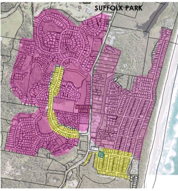
This page has been intentionally left blank
Chapter E5 – Certain Locations in Byron Bay and Ewingsdale

Contents
E5.1    Introduction............................................................................................................ 7
E5.2    Application of this Chapter ................................................................................... 7
E5.3    Aims of this Chapter.............................................................................................. 7
E5.4    Development Controls .......................................................................................... 7
E5.4.1 Development and servicing of land affected by predicted coastal hazards............... 7
E5.5    Habitat ...................................................................................................................10
E5.5.1 Where this Section Applies .....................................................................................10
E5.5.2 Objectives of this Section........................................................................................10
E5.5.3 Desired Future Character and Development Principles ..........................................11
  E5.5.3.1 Statement of Desired Future Character .........................................................11
  E5.5.3.2 Planning Principles ........................................................................................11
  E5.5.3.3 Achieving the Desired Future Character ........................................................12
  E5.5.3.4 Precinct Plan .................................................................................................12
E5.5.4 Design and Development Controls .........................................................................14
  E5.5.4.1 Land Use, Management and Environmental Assessment ..............................14
  E5.5.4.2 Car Parking ...................................................................................................17
  E5.5.4.3 Building Design .............................................................................................21
  E5.5.4.4 Site and Open Space Design ........................................................................23
  E5.5.4.5 Lot Size and Subdivision ...............................................................................25
  E5.5.4.6 Water Cycle Management .............................................................................26
  E5.5.4.7 Ecological Enhancement ...............................................................................28
E5.6    Byron Central Hospital Locality...........................................................................31
E5.6.1 Where this Section Applies .....................................................................................31
E5.6.2 Objectives of this Section........................................................................................31
E5.6.3 Landscaped Buffer .................................................................................................31
E5.7    The North Byron Beach Resort Site ....................................................................32
E5.7.1 Where this Section Applies .....................................................................................32
E5.7.2 Objectives of this Section........................................................................................32
E5.7.3 Statement of Desired Future Character ..................................................................33
E5.7.4 Planning Principles .................................................................................................34
E5.7.5 Achieving the Desired Future Character .................................................................35
E5.7.6 Development Applications and Site Concept Plan ..................................................36
E5.7.7 Conservation Areas and Corridors ..........................................................................37
  E5.7.7.1 Western Wetland and Heath Precinct C ........................................................37
  E5.7.7.2 Southern Wildlife Corridor Precinct D ............................................................38
  E5.7.7.3 Eastern Wetland and Littoral Rainforest Precinct E .......................................39
E5.7.8 Buffers and Hazards ...............................................................................................40
  E5.7.8.1 Bush Fire Asset Protection Zones .................................................................40
  E5.7.8.2 Water Body Buffers .......................................................................................40
  E5.7.8.3 Mosquito Management ..................................................................................41
E5.7.9 The Developable Area ............................................................................................41
  E5.7.9.1 Built Form ......................................................................................................41
  E5.7.9.2 Low Density Perimeter (Precinct 1) ...............................................................42
  E5.7.9.3 Central Development Area (Precinct 2) .........................................................42
  E5.7.9.4 Drainage and Water Cycle Management .......................................................43
  E5.7.9.5 Landscape .....................................................................................................44
  E5.7.9.6 Tourism Management....................................................................................44
E5.7.10 Environmental Management and Repair .................................................................45
  E5.7.10.1 Beach Access................................................................................................45
  E5.7.10.2 Environmental Management ..........................................................................45
E5.8    Residential Character Narratives – Byron Bay, Sunrise Beach and Wategos ..48

Byron Shire Development Control Plan 2014 – Chapter E5 – Certain Locations in Byron Bay and
Ewingsdale
Adopted:                  Effective:                                                                                               3
E5.8.1      Where this Section Applies .....................................................................................48
E5.8.2      Purpose ..................................................................................................................48
E5.8.3      Design Considerations............................................................................................48
E5.8.4      Character Narratives...............................................................................................49

Maps
Map E5.1 – Byron Bay Coastal Hazards Map ........................................................................ 9
Map E5.2 – Habitat...............................................................................................................29
Map E5.3 – Habitat Precinct Plan .........................................................................................30
Map E5.4 – North Byron Beach Resort Precinct Map ............. Error! Bookmark not defined.

Figures
Figure E5.1 – Indicative examples of Byron vernacular ........................................................21
Figure E5.5 Byron Bay, Sunrise Beach and Wategos Residential Character Areas …..…52

Tables

Table E5.1 – Land Uses Consistent with Desired Future Character .....................................15
Table E5.2 – Setbacks .........................................................................................................17
Table E5.3 – Car Parking Standards ....................................................................................19

          red = changes to reflect Residential Character narratives

          blue = changes to reflect draft updates to E5.5                        Habitat (as exhibited 1 - 29 June
                      2020)

Byron Shire Development Control Plan 2014 – Chapter E5 – Certain Locations in Byron Bay and
Ewingsdale
Adopted:                  Effective:                                                                                                  4
Document History
Doc No.           Date Amended         Details (e.g. Resolution No.)

#E2014/19980     20 March 2014         Res 14-118 - Public exhibition version

#E2014/33071                           Draft to 26 June 2014 Extraordinary Meeting - for adoption

#E2014/43427     26 June 2014          Adopted Version – Res 14-315

#E2017/104988    November 2017         Res 17-224 Public Exhibition version (#E2017/104987 - Marked
                                       Up Version)

#E2018/6783      February 2018         Draft to 22 February 2018 Ordinary Council Meeting – for adoption
E2018/19959      15 March 2018         Adopted Version – Res 18-081, Effective 15 March 2018

E2019/29357      April 2019            Public exhibition version – Revision 3 (Res 19-091)

E2019/29357      July 2019             New revision for adoption 15 August 2019 planning meeting

E2019/65501      15 August 2019        Adopted 15 August 2019 Effective 11 September 2019 – Res 19-
                                       374

E2019/84596      19 November 2019      Draft to 12 December meeting – public exhibition version

E2020/16606                            No submissions received
                                       Adopted 14 February 2020 Effective 11 March 2020 – Res 19-692
E2020/26874      14 April 2020         Draft to 21 May meeting – public exhibition version
(pdf
E2020/31046)
#E2020/45627     June 2020            Res 20-218 – Public exhibition version incorporating residential
                                      character narrative
                 September 2020        Update to E5.5 Habitat following exhibition

Byron Shire Development Control Plan 2014 – Chapter E5 – Certain Locations in Byron Bay and
Ewingsdale
Adopted:                  Effective:                                                                5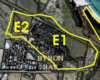
This page has been intentionally left blank

Byron Shire Development Control Plan 2014 – Chapter E5 – Certain Locations in Byron Bay and
Ewingsdale
Adopted:                  Effective:                                                          6
E5.1            Introduction
Byron Bay is an iconic coastal town characterised by spectacular beaches and coastline. It is
a relatively low density urban place with a compact, walkable CBD and a predominance of
one and two storey development in residential areas with three storeys in the business
area. It is partly affected by coastal hazards and flooding.

E5.2            Application of this Chapter
This Chapter applies to certain land at Byron Bay and Ewingsdale that is subject to Byron
LEP 2014. The land to which this Chapter applies is only that land identified in this Chapter.

E5.3            Aims of this Chapter
The Aims of this Chapter are:
     1. To identify land in Byron that may be affected by future coastal hazards and to
         apply development controls proportionate to the hazards affecting that land.
      2.   To identify land on Bayshore Drive, Byron Bay that is suitable for an innovative
           suite of land uses that will result in a compatible mix and density of business,
           office, residential, retail, light industry and other development on the site.
      3.   To facilitate the development of a new hospital for Byron Bay on Ewingsdale
           Road and ensure that it fits well with its surrounding rural locality.
      4.   To facilitate the responsible development of land at the Eastern end of Bayshore
           Drive for tourist and visitor accommodation and related uses while preserving
           and regenerating the vegetation on the site.

E5.4            Development Controls
E5.4.1          Development and servicing of land affected by
                predicted coastal hazards

Objectives
     1. To define how public utility services may be provided to development which is
         potentially threatened by coastal hazards.
      2.   To ensure the impact of coastal hazards on potential development is minimised
           by ensuring any development ceases as the erosion escarpment approaches the
           development.

Performance Criteria
1.   Vehicular access, water, sewerage, electricity, telephone and other services must be
     located so as to minimise the impact from actual or predicted coastal hazards.

Byron Shire Development Control Plan 2014 – Chapter E5 – Certain Locations in Byron Bay and
Ewingsdale
Adopted:                  Effective:                                                          7
2.    Development on land marked as ‘Coastal Erosion Hazard Area’ on the Byron Bay
      Coastal Hazards Map (Map E5.1) must be designed to be relocated or demolished, or
      to cease operation, should the erosion escarpment come within 50 metres.

Prescriptive Measures
1.   All services must be provided from the landward side of the development such that the
     building is between the services and the erosion escarpment.
2.    Development within the ‘Coastal Erosion Hazard Area’ on the Byron Bay Coastal
      Hazards Map (E5.1) will be considered on the understanding that any consent granted
      will be subject to the proviso that should the erosion escarpment come within 50
      metres of any building then the development consent will cease.
3.    If the development consent does cease then the owner of the land will be responsible
      for the removal of all buildings.
4.    The option of demolition as the means of removal will be available to all buildings.
5.    Prior to the issue of a Construction Certificate a restriction as to user must be placed
      on the title pursuant to the provisions of section 88E of the Conveyancing Act 1919,
      stating:
      “The subject land and any improvements erected thereon must not be used for
      the purpose of (land use) in the event that the erosion escarpment as defined by
      the Works and Services Director of the Council of the Shire of Byron from time to
      time comes to within 50 metres of any buildings or any part thereof at any time
      erected on the said land’.

Byron Shire Development Control Plan 2014 – Chapter E5 – Certain Locations in Byron Bay and
Ewingsdale
Adopted:                  Effective:                                                             8
Map E5.1 – Byron Bay Coastal Hazards Map

Byron Shire Development Control Plan 2014 – Chapter E5 – Certain Locations in Byron Bay and
Ewingsdale
Adopted:                  Effective:                                                          9

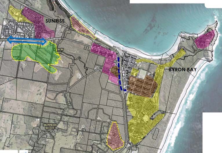
E5.5            Habitat
E5.5.1          Where this Section Applies

This section applies to the land defined by a heavy black line on Map E5.2 known as Habitat,
and identified as Lot 3 DP1004514, Bayshore Drive, Byron Bay. It is bounded by the Byron
Bay Arts and Industry Estate to the south, the West Byron Sewage Treatment Plant to the
west, regenerating heathland, shrubland and low woodland to the north, and the Sunrise
Beach residential estate to the east.

In the event of any inconsistency between Section E5.5 and other Chapters of this DCP, the
provisions of Section E5.5 shall prevail.

E5.5.2          Objectives of this Section

The primary purpose of this Section is to provide standards for the future development of the
site. To assist in this regard, the objectives of this Section are to:

      1.   Promote and implement the principles of ecologically sustainable development
           identified in aims of Byron LEP 2014, in the planning, development and
           management of the site;
      2.   Contribute to the implementation of Byron Shire Affordable Housing Initiatives, the
           Biodiversity Conservation Strategy, the Byron Shire Cultural Policy and applicable
           objectives as outlined in the Community Strategic Plan ‘Our Byron, Our Future’.
      3.   Define a compatible mix and density of business, office, residential, retail, light
           industry, business tourism and other development on parts of the site;
      4.   Seek to increase the range of housing choice and further promote affordable living
           opportunities.
      5.   Enhance and protect the bio-physical environment, particularly the Wallum
           vegetation and wildlife habitat adjacent to the site;
      6.   Enhance and protect ground water and surface water quality and hydrology;
      7.   Ensure that the siting, scale and intensity of development enhance and protect
           Byron Bay’s social and cultural qualities by:
           a)   responding to local and regional values, community needs and aspirations;
           b)   reflecting Byron Bay’s character and scale;
           c)   ensuring that development of the site contributes to the range of services
                available and the identity of West Byron; and
           d)   ensuring that site access does not compromise the amenity or safety of
                adjacent residential areas.

Byron Shire Development Control Plan 2014 – Chapter E5 – Certain Locations in Byron Bay and
Ewingsdale
Adopted:                  Effective:                                                             10
E5.5.3 Desired Future Character and Development Principles
E5.5.3.1 Statement of Desired Future Character
Habitat provides a vibrant and sustainable urban environment, which enhances social equity,
economic vitality, environmental performance and sustainability, and cultural expression
within the Byron Bay community.
It provides a wide range of housing and employment choice and has strong connections to
nearby shops, industry, town services, facilities and transport corridors.
A mix of housing types and small scale creative enterprises contribute to the
neighbourhood’s vitality and the town’s identity. Dwelling types reflect the household profile
of Byron Bay. Smaller dwellings and multiple dwelling types cater for Byron’s higher than
average proportion of group households and lone person households. Integrated work and
living spaces provide affordable and flexible opportunities for small scale businesses.
Commercial ventures provide for local employment, creative industries, an outlet for goods
and services produced on the site, and opportunities for business collaboration and business
tourism.
Land is used efficiently and energy and water use is minimised. The community actively
contributes to the enhancement and maintenance of important habitats on adjoining land.
Buffers are provided to these adjoining habitats, and to bushfire hazards and the West Byron
Sewage Treatment Plant. Edges are well defined, the public domain is safe and permeable
and amenity is fostered by transitions between uses and by integrated site planning.
E5.5.3.2 Planning Principles
The desired future character reflects the following planning principles:
1. Social Equity
a) Enables the co-location of uses to provide housing close to employment
opportunities while ensuring potential conflict between the different land uses
is minimised;
b) Provides a range of low cost residential and live/ work solutions that will
enable creative artisans/business people to establish an economically
achievable base; and
c) Includes a mix of housing, ownership patterns, prices and building types for a
diverse community.
2. Economic Vitality
a) Provides a mix of employment opportunities with particular emphasis on
creative industries;
b) Facilitates a density of development (with amenity) which makes cost
effective use of scarce land; and
c) Embraces the concept of shared opportunities and synergies within the
surrounding neighbourhood, which contributes to overall efficiencies.
3. Environmental Performance
a) Facilitates a smaller environmental footprint than traditional suburban
development;
Byron Shire Development Control Plan 2014 – Chapter E5 – Certain Locations in Byron Bay and
Ewingsdale
Adopted: Effective: 11b) Utilises a site sensitive approach which provides filters and buffers protecting
the ecological values of adjoining lands;
c) Provides for habitat enhancement that integrates with work previously
undertaken on adjoining land to restore significant new wetland habitat.
4. Cultural Expression
a) Encourages a clustering of artistic and lifestyle based small scale industries;
and
b) Promotes the cultural identity of the area by building upon the commercial /
services and industrial base in the surrounding neighbourhood.
E5.5.3.3 Achieving the Desired Future Character
This Plan aims to achieve the Desired Future Character of the site as described in Section
E5.5.3.1 by:
1. Providing a Precinct Plan for the major elements of Habitat (refer to Map E5.3);
2. Specifying Principles that must apply to development of the site;
3. Specifying objectives, performance criteria and prescriptive measures for a
number of environmental elements relevant to the future development of Habitat;
and
4. Specifying ecological enhancement measures that are to be undertaken in
adjoining habitats.
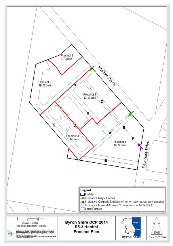
E5.5.3.4 Precinct Plan
1. The Habitat Precinct Plan (Map E5.3) identifies the major bio-physical elements
that will make up the structure of the developed site. These elements include:
a) Major entries/ exits;
b) Internal access connections;
c) Land use ‘precincts’, including:
i) Precinct 1A - Tiered living. Mixed use, commercial premises, hotel or
motel accommodation, residential flat building, serviced apartments, high
technology industry, function centre, information and education facility,
medical centre, recreation facility (indoor), and food and drink premises.
ii) Precinct 1B - Mixed use, retail / business / food and drink / recreation
facility (indoor).
iii) Precinct 2 - pocket living.
iv) Precinct 3 - warehouse lofts.
v) Precinct 4 - mixed use, retail / business / residential / café / community
recreation facilities / commercial terraces.
vi) Precinct 5 - ecological enhancement.
2. The Precinct Plan provides a framework for development in Habitat. It will assist
developers and designers to obtain an understanding of the context for their
proposed development. Components of the plan include the following:
Byron Shire Development Control Plan 2014 – Chapter E5 – Certain Locations in Byron Bay and
Ewingsdale
Adopted: Effective: 12a) Major entries/ exits
The major entries / exits for Habitat will be from Wallum Place, at the northern
frontage of the site. Entry-only service access and entry-only access to car
parking areas within the site will be from Bayshore Drive, at the eastern frontage of
the site.
b) Precinct 1
i. Precinct 1A: Tiered Living Mixed Use
Tiered Living consists of 8x two-and-a-half storey buildings along the northern
edge of the site (half storey comprised of a mezzanine or loft that utilises the roof
space). Tiered living provides for a range of housing options, with 12x one
bedroom units, 22x two bedroom units and 12x three bedroom units.
Mixed use entails commercial premises, hotel or motel accommodation, residential
flat building, serviced apartments, high technology industry, function centre,
information and education facility, medical centre, recreation facility (indoor), and
food and drink premises.
ii. Precinct 1B: Mixed Use
The Precinct will offer a mix of business, retail, recreation facilities (indoor) and
food and drink, including: approx. 450m2 of retail space; approx. 900m2 of
commercial office space; 615m2 of recreation facilities (indoor) and 105m2 of food
and drink premises space.
c) Precinct 2: Pocket Living
The Pocket Living Precinct consists of 4x two-and-a-half storey buildings along
the north western edge of the site and an amenities block (half storey comprised
of a mezzanine or loft that utilises the roof space). This precinct offers the
opportunity for high quality, small scale living units at an affordable price point and
is comprised of 56x one bedroom units and 4x two bedroom units.
d) Precinct 3: Warehouse Lofts
The Warehouse Lofts consist of 4x two storey buildings along the southern edge
of the site. Each building is comprised of six ground floor commercial/retail spaces
with a one-bedroom apartment above. There is also an option for a second
bedroom on the ground floor. This integrated solution will suit many creative
industries.
e) Precinct 4: Retail / Business / Residential / Café / Community Recreation
Facilities
This area offers a mix of business, retail and living spaces including; approx.
1200m2 of retail space; approx.1700m2 of commercial office space plus a
café/restaurant, gym and pilates studio, as well as 10x two bedroom apartments,
with attached retail or commercial workspaces. The recreational precinct includes
a swimming pool, change rooms, barbecue areas, bicycle storage and shaded
lawn.
f) Precinct 5: Ecological Enhancement
Existing low lying areas or swales on adjoining lands will be extended and
revegetated with freshwater wetland and heath plant species of local provenance
to improve wetland habitats and increase important habitat components for local
fauna species, particularly the Wallum frogs (Wallum Sedge frog, Litoria
Byron Shire Development Control Plan 2014 – Chapter E5 – Certain Locations in Byron Bay and
Ewingsdale
Adopted: Effective: 13olongburensis, Wallum froglet Crinia tinnula). Appropriate restrictions on the title
of the property (Lot 3) will ensure that the community will continue to contribute to
the maintenance of these important Wallum frog habitats.
E5.5.4 Design and Development Controls
Section E5.5.4 contains a range of controls which reflect environmental and design aspects
of the future development of Habitat.
E5.5.4.1 Land Use, Management and Environmental Assessment
Background
A key characteristic of villages is the mix of uses that occur throughout them. Mixing uses
facilitates a vibrant and safe environment by day and by night. The close proximity of
workplaces and housing reduces travel distances and creates affordable and accessible
urban environments. The economic viability of the development is supported over its life
cycle by the provision of both housing and productive uses. Provision of a variety of housing
types and configurations supports a diversity of households and reflects local demands for
differentiated and affordable housing options.
The site has a number of constraints which will require detailed environmental assessment
as part of any future development application for the site. These constraints include
proximity to the West Byron Sewage Treatment Works and its primary access road, potential
acid sulfate soils, and various ecological constraints.
Objectives
1. To achieve the Desired Future Character for the site as defined by Section
E5.5.3.1;
2. To facilitate the creation of a mixed use development with a diversity of housing
and employment choice and optimum density that reflects the environmental
capability of the site and the socio-economic and cultural context; and
3. To assess and mitigate potential environmental impacts.
Performance Criteria
1. Utilise the site and building layout to maximise the potential for acoustic privacy by
providing adequate building separation within the development and from neighbouring
buildings;
2. In Precinct 1, utilise front fences and walls to enable use of private open space abutting
Wallum Place to provide an acoustic barrier to vehicle movements;
3. In mixed use development, ensure loading bays, garbage collection areas etc are
located away from bedrooms and other quiet areas in the residential component;
4. Provide diverse dwelling types within Precincts 1, 2, 3 and 4;
5. In Precinct 1, provide spaces to be used for a home office, creative industry or as an
additional bedroom.
Prescriptive Measures
1. Land Use and Density
a) Distribute land uses across the site in accordance with the Precinct Plan (Map
E5.3) and the consistent land uses and densities outlined in Table E5.1; and
Byron Shire Development Control Plan 2014 – Chapter E5 – Certain Locations in Byron Bay and
Ewingsdale
Adopted: Effective: 14b) Provide for a maximum of 152 residential dwellings within the site.
Table E5.1 – Land Uses Consistent with Desired Future Character
Precinct Consistent Land Maximum Densities*
Uses*
Precinct 1A - Tiered Living (TL) Tiered Living
- Commercial -
Land Area: premises, - Mix of configurations ranging from
Approximately - 1 – 3 bedrooms depending on how
8,419m2 - Co-working, the space is used.
- Food and drink - Garage to ground floor.
Built Gross Floor premises,
Area: - Hotel or motel Mixed Use
Approximately accommodation,
6,042m2 - Serviced - 1, 2 & 3 bedroom serviced
6,700m2 apartments, apartments / residential
- High technology apartments to support the live/
Bedrooms Total: industry, work concept’,
126 - Function centre, - 1 & 2 bedroom hotel or motel
- Information and rooms to meet the needs of
education facility, business tourism,
- Medical centre, - Retail and commercial premises
- Recreation facility (class 5/6) to various levels,
(indoor) and food - Medical centre and recreation
and drink premises. facility (indoor) to various levels,
- Function centre, information and
education facility , high technology
industry,
- Food and drink premises,
- Shared meeting rooms, WC’s,
garbage facilities,
- Back of house,
- Underground car parking.
Precinct 1B - Retail - Retail (class 6) to the lower level.
- Business - Commercial (class 5) to the upper
Land Area: - Food and Drink two levels.
Approximately - Recreation - Food and drink and Recreation
3,710m2 Facilities (indoor) Facilities (indoor) to the lower
level.
Built Gross Floor - Shared meeting rooms, WC’s,
Area: storage and garbage facilities.
2,160m2
Precinct 2 Pocket Living (PL) Pocket Living
Land Area: - Mix of 1 + 2 bedroom units to
Approximately ground floor
10,255m2 - 1 bedroom units to first floor
Built Gross Floor
Byron Shire Development Control Plan 2014 – Chapter E5 – Certain Locations in Byron Bay and
Ewingsdale
Adopted: Effective: 15Precinct Consistent Land Maximum Densities*
Uses*
Area:
3,655m2
Bedroom Total:
64
Precinct 3 Warehouse Lofts (WL) Warehouse Lofts
Land Area: - Commercial / retail to the ground
Approximately floor (class 5 / 6)
7,360m2 - Generally residential to the first
floor with additional bedroom
Built Gross Floor permissible to ground floor
Area: - Able to be configured with 1 or 2
3,200m2 beds
Bedroom Total:
48
Precinct 4 - Retail Commercial Precinct
- Business B1 / C1 / C2 / C3 / C4 / C5
Land Area: - Residential
Approximately - Café - Retail (class 6) to lower level with
16,740m2. - Community / the exception of C5 (dentist)
Recreation - Commercial (class 5) to upper
Built Gross Floor Facilities level with the exception of C1
Area: 5,325m2 (gym) C3 and C5 (pilates studio)
- Shared meeting rooms and wc’s
Bedroom Total:
20
Recreation Precinct
- Swimming pool and change
facilities
Commercial Terraces
- Part of the ground floor is
commercial/retail (class 5/6)
- Rear portion of the ground floor
and all upstairs is residential (class
2)
- 2 bedrooms
Precinct 5 Ecological No buildings allowed
enhancement,
Land Area: restoration,
Approximately management and
2,728m2 monitoring.
Byron Shire Development Control Plan 2014 – Chapter E5 – Certain Locations in Byron Bay and
Ewingsdale
Adopted: Effective: 162. Setback
Provide setbacks within the development consistent with the minimum distances outlined in
Table E5.2.
Table E5.2 – Setbacks
Land Use Minimum Setback Distance (m)
Precinct 1 External Property (lot) Boundary 42
External road 97
Internal roads 0
Adjoining buildings 0
Precincts External Property (lot) Boundary 4
2&3
Internal roads 0.5
Adjoining Buildings 0
Precinct 4 Bayshore Drive 7
Wallum Place 4
Internal Roads 0
3. Buffering
a) Provide a minimum 20m setback between dwellings and the western and north-
western site boundaries, where these adjoin the adjacent Wallum frog habitats;
b) Provide a minimum 5m setback between dwellings and the internal boundary
between Precincts 2 and 5, located in the north-western corner of the site as
denoted by the approved Acid Frog Management Plan (GeoLINK, 2017) for the
site; and
c) Provide buffering from the Byron Bay Sewerage Treatment Works in the form of a
minimum 20m buffer along the north western boundary of the site (this
acknowledges the buffer provided in the original subdivision of the land, by the
creation of Lot 12 DP 1189646).
4. Environmental Assessment
The following environmental assessment reports must be prepared as part of any
development application for the site:
a) Preliminary Acoustic Report;
b) Site Waste Minimisation and Management Plan and assessment consistent
with the requirements of Chapter B8 Waste Minimisation and Management.
E5.5.4.2 Car Parking
Byron Shire Development Control Plan 2014 – Chapter E5 – Certain Locations in Byron Bay and
Ewingsdale
Adopted: Effective: 17Background
An integrated ‘live/work’ approach to development, characterized by the inclusion of
workspaces in detached and attached residential dwellings, presents the opportunity for
dual use of parking spaces, thereby reducing the overall parking demand of the proposed
development.
Dual use of parking spaces occurs when the same parking space can serve more than one
component of a development, such as where residents of living areas also operate
businesses in the attached workplaces. In circumstances where the parking demand
generated by residents is satisfied by parking provided to serve the living areas, there is no
need to satisfy the parking demand generated by residents’ use of the workplaces.
A mixed use development also provides the potential for complementary use of parking
spaces. This occurs when the peak parking demand of one component of the proposed
development does not coincide with the peak parking demand of another.
Objectives
1. To provide sufficient parking to satisfy the needs of the proposed development
taking into account the potential for dual and complementary use of parking
spaces; and
2. To assist in achieving the Desired Future Character for the site as defined by
Section E5.5.3.1 by minimising the total area of hard stand car parking within the
site.
Performance Criteria
1. Provide on-site car parking appropriate to the needs of both residents and off-site
workers, with consideration to potential for dual use and complimentary use of spaces;
2. Dual Use Parking - apply the concept of dual use parking, as described above, as
appropriate to the nature of the proposed site development. In this regard it is not
unreasonable to expect that the actual parking demand generated by the workplace
floorspace in the commercial precinct (most notably the office floorspace), and in the
industrial precinct, will be up to 30% less than the parking requirement which is
calculated without regard to the duplication of parking provision, which is a
consequence of the integrated “live/work” approach to the development. It should be
noted, however, that it is possible that not all of the workforce employed by businesses
that occupy the workplaces incorporated in integrated ‘live/work’ components of a
mixed use development will also be residents of that development. For example, a
resident operating a business from a workplace could employ a non-resident/residents
to assist in the operation of the business;
3. Complementary Use - seek to reduce the total number of car parking spaces
associated with a mixed use development proposal by comparing peak demands of
each use by time of day, day of the week, and season. Where the varied parking
demand for proximate uses allows joint use of a single parking space or facility, a
reduced number of spaces is strongly encouraged;
4. Located shared parking spaces to be convenient to all users;
5. Provide non-residential parking on internal streets and accessways, providing that such
parking does not affect the capacity of the internal access system to allow efficient
internal movement of vehicles and pedestrians; and
6. Provide cycle access and facilities within the site, consistent with the requirements of
Chapter B5 Providing for Cycling.
Prescriptive Measures
Byron Shire Development Control Plan 2014 – Chapter E5 – Certain Locations in Byron Bay and
Ewingsdale
Adopted: Effective: 18Provide on-site car parking in accordance with standards outlined in Table E5.3. Total
provision of car parking is to consider potential for dual use and complementary use, as
described above.
Table E5.3 – Car Parking Standards
Type of Development Minimum Car Special Requirements Precinct
Parking Requirements
Provision
Precinct 1A – Tiered Living Mixed Use
large dwellings - 3 or 4 2 spaces per 1 space must be 1 per cent of
bedrooms dwelling capable of being spaces to be
covered (stacked car provided for
parking will not be people with a
acceptable) disability
small dwellings – 1 1 space per
bedroom dwelling
visitor car parking 1 space per 4
dwellings
Workspace 1 space per
workspace
delivery / service 1 space per 50 Visitor parking can be
vehicles units used if designed for
dual use
Apartment 1 space per room 1 space to be provided Where car share
+1 per 4 for visitor for people with a is provided the
disability for each maximum car
accessible room. parking credit
Bike shop 1 space per 20m2 shall be on the
GFA basis of 1 car
Co-retail 1 space per 20m2 share space per 5
GFA spaces. Car
Commercial Kitchen 1 space per 20m2 share cannot
GFA account for more
Hotel 1 space per room 1 space to be provided than 10% of the
for people with a overall required
disability for each parking.
accessible room
Networking 1 space per 20m2 1 per cent of
GFA spaces to be
New retail 1 space per 40m2 provided for
- Office premises GFA x 70% people with a
1 space per 20m2 disability
- Retail Premises GFA (generally – does
Office 1 space per 40m2 not apply hotel/
GFA x 70% serviced
Restaurant 1 space per 20m2 apartments)
GFA
Retail 1 space per 20m2
GFA
Sauna Ancillary to Hotel
Special function centre 1 space per 20m2
GFA
Studio 1 space per 20m2
Byron Shire Development Control Plan 2014 – Chapter E5 – Certain Locations in Byron Bay and
Ewingsdale
Adopted: Effective: 19Type of Development Minimum Car Special Requirements Precinct
Parking Requirements
Provision
GFA
Wellness Centre 1 space per 40m2
GFA x 70%
Hotel Staff 1 per 2 employees
Delivery/Service Provide Specific
Vehicles Loading Bay
Precinct 1B –Mixed use, retail / business / food and drink / recreation facility (indoor)
Retail 1 space per 20m2 1 per cent of
gross floor area spaces to be
Office / professional 1 space per 40m2 provided for
rooms / business gross floor area x people with a
premises 70% disability
Recreation facility 1 space per 20m2
(indoor) gross floor area
delivery / service 1 space per
vehicles 400m2
Precinct 2 – Pocket Living
small dwellings – 1 1 space per 1 per cent of
bedroom dwelling spaces to be
small dwellings – 2 1.5 spaces per provided for
bedroom dwelling people with a
delivery/ service 1 space per 800 Visitor parking can be disability
vehicles m2 gross floor used if designed for
area dual use
Precinct 3– Warehouse Lofts
small dwellings 1 space per 1 per cent of
(1bedroom) dwelling spaces to be
provided for
small dwellings – 2 1.5 spaces per people with a
bedroom dwelling disability
visitor car parking 1 space per 4
dwellings
Workspace 1 space per
workspace
delivery / service 1 space per 800 Visitor parking can be
vehicles m2 gross floor used if designed for
area dual use
Precinct 4 – Mixed Use
retail 1 space per 20 m2 1 per cent of
gross floor area spaces to be
office / professional 1 space per 40m2 provided for
rooms/ business gross floor area x people with a
premises 70% disability
2
spa 1 space per 20m
gross floor area
small dwellings (1 or 2 1.5 spaces per
bedrooms) dwelling
large dwellings (3 or 4 2 spaces per
bedrooms) dwelling
visitor car parking 1 space per 4
dwellings
delivery / service 1 space per 400
Byron Shire Development Control Plan 2014 – Chapter E5 – Certain Locations in Byron Bay and
Ewingsdale
Adopted: Effective: 20Type of Development Minimum Car Special Requirements Precinct
Parking Requirements
Provision
vehicles m2
E5.5.4.3 Building Design
Background
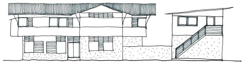
The climate, coastal location and the evolving culture of Byron Bay has given rise to a ‘Byron
style’ which can be characterised as informal, light weight construction and is referred to in
this Section as the ‘Byron vernacular’ and the ‘Byron style’. Achieving the Byron vernacular
will be reinforced within the developments’ residential precincts, with the development as a
whole characterised by lush vegetation, open spaces and linked landscaped areas, a mix of
flat and sloping rooflines, timber, masonry and glass structures typical of the local Byron
style (refer to Figure E5.1).
An opportunity exists for Habitat to be an intense living and working environment of a
considerably higher density than suburbia. Consequently, a high degree of detailed design
resolution is required in the architecture and urban design.
The density proposed for the site means that the form and layout of each building needs to
consider its relationship to its immediate neighbour and its context in the street. It means
that the creation of identifiable and well defined space in the public domain is more important
than the individual building and garden. Further, it means that gardens and the landscaping
on private lots need to contribute to the public domain. The issue of overshadowing will also
need to be carefully considered in any design for the site.
Building design should:
1. Reinforce the structure of the public domain;
2. Respond to climate and local ‘Byron vernacular’;
3. Ensure privacy and amenity are maintained;
4. Contribute to high environmental performance; and
5. Ensure an adequate level of solar access is provided to living areas.
Byron Shire Development Control Plan 2014 – Chapter E5 – Certain Locations in Byron Bay and
Ewingsdale
Adopted: Effective: 21Figure E5.1 – Indicative examples of Byron vernacular
Objectives
1. To achieve the Desired Future Character for the site as defined by Section
E5.5.3.1;
2. To ensure that buildings on the site reinforce the structure of the public domain,
respond to climate and the ‘Byron vernacular’, ensure that privacy and amenity are
maintained, and contribute to high environmental performance;
3. To ensure that residential development will not significantly increase the
overshadowing of adjoining properties; and
4. To ensure that occupants of buildings will enjoy the optimum use of winter sunlight
and summer shade.
Performance Criteria
1. Provide low-rise) two and three storey building forms that are in proportion to street
trees or existing built form. Two and (half storey comprised of a mezzanine or loft that
utilises the roof space) are also possible.
2. Where possible, provide rear lane vehicular access to housing sites to facilitate a
coherent, safe and visually pleasing streetscape and negate the need for private hard
surfaced driveways;
3. Provide articulation and variety in building forms and utilise screening features to
facilitate visual interest, privacy and energy efficiency;
4. Ensure that the width and internal layout of buildings facilitate natural cross ventilation;
5. Design entrances so that they are a clearly identifiable element of the building in the
street;
6. Utilise durable materials and finishes;
7. No roof should have a highly reflective surface; any metal roof must have a colorbond
or equivalent finish in a colour approved by Council. White or light coloured roofing will
not be approved where it’s likely to be intrusive;
8. Locate habitable rooms and open spaces away from noise sources and utilise car
parking areas and zero side building setbacks to provide a buffer to noise sources;
9. In Precinct 1, design and construct development adjoining Wallum Place to ensure that
acceptable living conditions can be created within dwellings, particularly in relation to
noise and odour;
10. Incorporate lush vegetation to provide shade and screening; and
11. Orientate dwellings and design building roof and shade structures to maximise solar
access into private open space areas and internal living spaces during winter months.
Byron Shire Development Control Plan 2014 – Chapter E5 – Certain Locations in Byron Bay and
Ewingsdale
Adopted: Effective: 22Prescriptive Measures
1. Provide details of building materials and surface colours for assessment with the
development application;
2. External materials must complement the ‘Byron vernacular’ and can include various
forms of cladding including pre-painted corrugated steel, fibrous cement,
weatherboard, masonry, concrete and timber;
3. Allow zero side setbacks and boundary walls to efficiently utilise the site, create an
urban edge to streets, minimise building material and energy usage, and enable the
provision of private internal open space;
4. Design buildings to ensure a minimum of 3 hours of sunshine to the living area of
dwellings between 9am and 3pm mid winter;
5. Coordinate and integrate building services, such as drainage pipes and air
conditioners, with overall façade and balcony design;
6. Coordinate security grills/ screens, ventilation louvres and car park entry doors with
the overall façade design;
7. Provide operable walls and large openings to allow for windows and doors to be
opened during summer and closed in winter;
8. Incorporate mosquito mitigation devices;
9. Locate living areas with direct access to private outdoor spaces; and
10. Avoid large expanses of any single material.
11. Design buildings to ensure that building heights do not exceed the maximum height
shown for the land on the Byron LEP 2014 Height of Buildings Map.
12. Design buildings to ensure that he maximum floor space ratio for a building is not to
exceed the floor space ratio shown for the land on the Floor Space Ratio Map.
E5.5.4.4 Site and Open Space Design
Background
The flat topography and high water table of the site and the sensitive wetland habitats of its
context mean that managing stormwater runoff will be important. Minimising impervious
surfaces across the site is critical to the reduction of stormwater runoff. This issue will also
be supported by building design and infrastructure design elements of this Section.
The provision of areas for communal exchange, relaxation, education and contemplation will
support the village concept. At the same time, territorial reinforcement of public and private
space will facilitate efficient utilisation of the land and discourage crime opportunities.
Universal access will need to be built into the design of the site at ground level in order to
produce a village that is supportive of people with the range of physical and mental
functionality.
The mixed use nature and density of the proposed land use pattern and the availability and
augmentation of existing cycling and walking networks delivers an opportunity to provide
wide transport choice. Minimising and integrating vehicular parking is a demand
management measure that can further support, walking, cycling and public transport.
Locating visitor parking within the street system reduces the footprint of dwelling sites.
Objectives
Byron Shire Development Control Plan 2014 – Chapter E5 – Certain Locations in Byron Bay and
Ewingsdale
Adopted: Effective: 231. To achieve the Desired Future Character for the site as defined by Section
E5.5.3.1; and
2. To minimise the impervious footprint of the site, provide communal and private
open space, delineate the public or private role of space and facilitate universal
access.
Performance Criteria
1. Provide common open space to facilitate communal exchange and foster a sense of
community;
2. Locate communal open space so that it exists as a focal point for the development;
3. Provide private outdoor open space areas in dwelling sites as an extension of living
spaces, to allow yards to be fully planted as landscaped deep soil areas and to
maximise pervious areas;
4. Provide private open space for workspaces by way of open space balconies as an
extension of living spaces;
5. Provide adequate facilities for storage, clothes drying and waste management while
minimising their visual and amenity impacts;
6. Provide universal access throughout the site by providing continuous accessible
paths of travel and some housing and car parking specifically designed to support
persons who have reduced physical or cognitive function;
7. Ensure communal open space areas are useable and accessible to all including those
persons with a disability;
8. Ensure passive surveillance of the communal open space area;
9. Improve the amenity of open space with landscape design by:
a) providing appropriate shade in the form of locally indigenous trees or structures;
b) providing accessible routes through the space and between buildings; and
c) screening cars, communal drying areas, swimming pools and the courtyards of
ground floor residential buildings;
10. Contribute to streetscape character and the amenity of the public domain by:
a) relating landscape design to the desired proportions and character of the
streetscape;
b) using planting and landscape elements appropriate to the scale of the
development; and
c) allowing for locating public art where they can be viewed by users of open space
and/ or from within courtyards and the public domain;
11. Improve the energy efficiency and solar efficiency of dwellings and the microclimate of
private open spaces. Planting design solutions include:
a) locally indigenous trees for shading low-angle sun on the eastern and western
sides of a buildings;
b) locating locally indigenous dense-foliaged trees well away from the building to
permit winter sun access;
c) varying heights of different species of locally indigenous trees and shrubs to
shade walls and windows; and
Byron Shire Development Control Plan 2014 – Chapter E5 – Certain Locations in Byron Bay and
Ewingsdale
Adopted: Effective: 24d) locating pergolas on balconies and courtyards to create shaded areas in summer
and private areas for outdoor living.
Prescriptive Measures
1. Public Open Space
a) Provide a minimum of 2,000m2 of public / communal open space, with at least one
central location having an area of not less than 450m2; and
b) Orientation of communal open spaces to the north with a minimum of three hours
of sunlight between 9am and 3pm mid winter provided to at least 50% of the
communal open space area.
2. Private Open Space
a) A private open space balcony must be provided for each dwelling where the
residential component is not located on the ground floor (note this includes
dwelling that contain a dwelling on the first floor and workspaces / office on the
ground floor). Within the commercial precinct, such private open space balconies
must have a minimum area of 10m2 and a minimum length and width of 2.5m.
Within the Pocket Living precinct, private open space balconies must have a
minimum area of 11m2. In all other precincts, the private open space balconies
must have a minimum area of 15m2 and a minimum length and width of 2.5m;
b) Private open space balconies must have appropriate orientation and adequate
provision for winter sun and summer shade; and
c) Each dwelling that has a residential component on the ground floor must have a
minimum private landscaped area of 49m2 (including terrace) plus additional
common outdoor area.
3. Universal Access
a) Provide a minimum of one dwelling as adaptable housing, designed in
accordance with AS4299, for every 10 dwellings or part thereof;
b) Design facilities for disabled persons (including car parking) to comply with the
Australian Standard 1428 (Part 1 and 2), the Building Code of Australia and the
Disability Discrimination Act 1992 (as amended);
c) Provide continuous accessible paths of travel from all public roads and public
spaces, as well as throughout the ground level internal spaces of adaptable
housing dwellings; and
d) Design adaptable housing dwellings in accordance with AS 1428 Parts 1, 2 and
4 and AS 4299 Adaptable Housing.
E5.5.4.5 Lot Size and Subdivision
Objectives
1. To provide lots of sufficient size to satisfy the needs of future residents and
occupants, and which will accommodate well designed and innovative
development;
2. To encourage diversity in lot size and opportunities for a variety of
housing/building choice; and
3. To ensure that lot design takes into account the natural features of the site and
locality.
Byron Shire Development Control Plan 2014 – Chapter E5 – Certain Locations in Byron Bay and
Ewingsdale
Adopted: Effective: 25Performance Criteria
1. Lots must be of sufficient area to allow for the siting of dwellings / buildings including
provisions for private open space, landscaped area, vehicle access and car parking
and to permit solar access; and
2. Lot sizes and design must enable dwellings / buildings and driveways to be sited to
protect natural or cultural features, and respond to site constraints including
topography, bushland, soil, erosion, drainage, and bushfire risk.
Prescriptive Measures
1. The minimum lot size requirements for the site (including residential community title)
shall be in accordance with Byron LEP 2014.
2. Lots must enable the construction of a built form which is sympathetic to the
established character of the area.
3. Subdivision of the site is to occur only through strata and/or community title
subdivision.
4. There is no minimum allotment size for strata subdivision provided the allotment
boundaries substantially correspond with parts of any building intended for separate
ownership. Demonstration of compliance with the Building Code of Australia with
regard to fire separation and egress will be required prior to subdivision approval.
5. In the case of strata or community-title subdivisions, car spaces are not to be given
separate lot numbers, and all visitor spaces are to be included within common property
where possible. All private landscape area attached to a dwelling shall be identified
on the subdivision plan as being part of the appropriate dwelling unit/ lot. All common
landscaped areas and community facilities shall be identified as being within the
common property.
E5.5.4.6 Water Cycle Management
Background
The wetland systems to the south-west and west of the site demand a water management
regime that ensures that water leaving the site is appropriately treated and managed.
Objectives
1. To achieve the Desired Future Character for the site as defined by Section
E5.5.3.1;
2. To ensure that management of surface water and ground water on the site is
consistent with the principles of Integrated Water Cycle Management and water
sensitive urban design; and
3. To protect the area’s sensitive ecological and geophysical environment,
particularly by ensuring that water released into the ground water and adjacent
swales is low in pH and nutrients.
Performance Criteria
1. Utilise uncontaminated, low pH, low nutrient fill to provide for drainage of stormwater
within and from the site;
2. Minimise building footprints by including three storey building forms in order to
maximise pervious open space areas;
Byron Shire Development Control Plan 2014 – Chapter E5 – Certain Locations in Byron Bay and
Ewingsdale
Adopted: Effective: 263. Minimise impervious surfaces dedicated to vehicular access and manoeuvring by
minimising the length of driveways and parking provided within individual house sites;
4. Incorporate water use minimisation measures, such as water saving devices, into
building designs;
5. Minimise filling of the site by adopting above-surface drainage regime with the use of
swales;
6. Council may consider variations to its engineering standards to allow swale drainage,
as an alternative to standard kerb and gutter drainage, if it can be demonstrated that
the swale drainage design could be adapted to conform to standard kerb and gutter
drainage in the event of system failure;
7. Avoid the need for deep basins or permanent pools for the detention of stormwater by
incorporating shallow detention areas or swales across the site which fully drain
following rainfall events;
8. Utilise car parking areas for the detention and treatment of stormwater runoff from
roads;
9. Ensure that stormwater leaving the site is treated to a quality equal or better to pre-
development quality;
10. Ensure that stormwater flow rates leaving the site are no greater than pre-development
flow rates;
11. Manage the flow and quality of water leaving the site to avoid adverse impacts upon
adjoining sensitive wetland areas, particularly in relation to maintaining low pH and low
nutrient levels;
12. Maximise the reuse of treated wastewater and stormwater for non potable purposes
such as garden watering and toilet flushing within site capability and public health
limits; and
Prescriptive Measures
1. Requirements of the site wide Integrated Water Cycle and Soil Management Plan
(Geolink, 2011) as amended by Stormwater Management Plan (Ardill Payne &
Partners, 2013) are to be adhered to;
2. Provide dual reticulation within the site for the reuse of recycled water from the West
Byron sewage treatment plant (STP) for toilet flushing and watering of open spaces
where suitable;
3. Rainwater tanks to be provided as required by the approved Stormwater Management
Plan (Ardill Payne and Partners, 2013);
4. Private courtyards are to minimise surfaces with impervious materials. Where timber
decking is provided, water must be capable of infiltrating into the soil beneath the deck;
5. Contribute to water and stormwater efficiency by integrating landscape design with
water and stormwater management, by:
a) using locally indigenous plants with low water demand to reduce water
consumption;
b) using locally indigenous plants with low fertiliser requirements;
c) using locally indigenous plants with high water demand, where appropriate, to
reduce run off from the site;
d) utilising permeable surfaces; and
e) incorporating wetland filter systems using locally indigenous plant species;
Byron Shire Development Control Plan 2014 – Chapter E5 – Certain Locations in Byron Bay and
Ewingsdale
Adopted: Effective: 27You can also read