Hove Station Area Supplementary Planning Document - Toad's Hole Valley Supplementary Planning Document (THV SPD) 15 - Brighton & Hove City Council
←
→
Page content transcription
If your browser does not render page correctly, please read the page content below
Draft for public consultation
               from 14 December 2020 to 7 February 2021

                                  Hove Station Area
  Supplementary Planning Document

Toad’s Hole Valley Supplementary Planning Document (THV SPD) 15   0
                                                                      i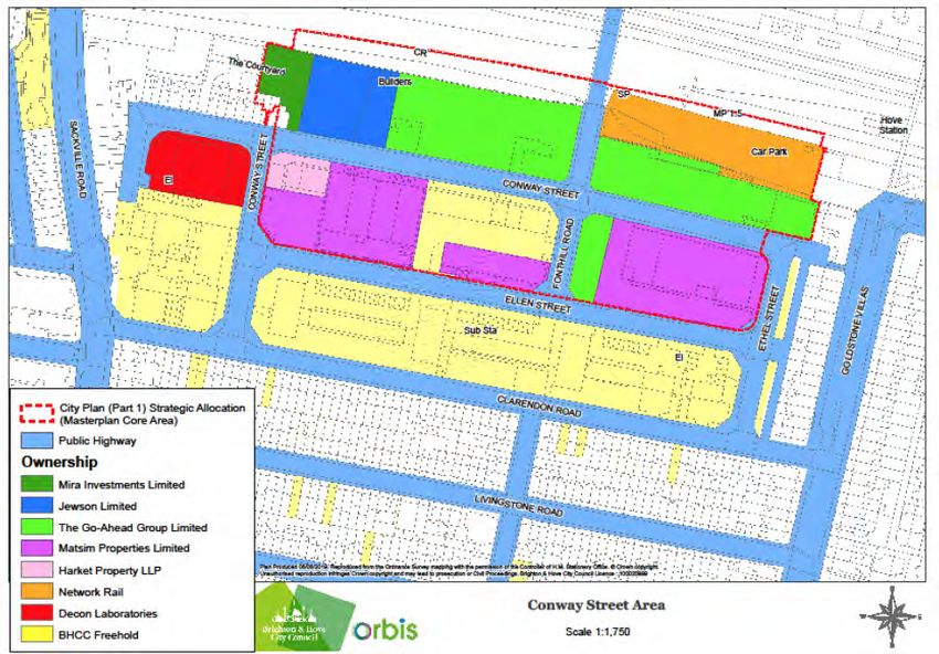
Contents

1    Introduction: Vision and purpose                2   5   Site specific opportunities             34
Purpose                                              2   Station Rise                                36

Structure                                            2   Honeycroft Centre Area                      38

Vision                                               2   Station Approach:                           40

2    Planning policy context                         4   Fonthill Road & Goldstone Street            42

3    Site and context analysis                      10   Pocket Park                                 43

Introduction                                        10   Ellen Street                                44

Site context                                        10   Ethel Street                                46

Heritage                                            15   Hove Park Villas Square                     47

Movement and access                                 16   6   Phasing and delivery                    48

Building heights                                    19   Appendix 1:                                 54

Positive and negative influences                    20 Unlocking the Station Area: Additional Note

4    Area wide strategy                             24   Appendix 2:                                 57

Layout Principles                                   30 Image copyright credits and permissions

Hove Station Area Supplementary Planning Document
                                                                                                          1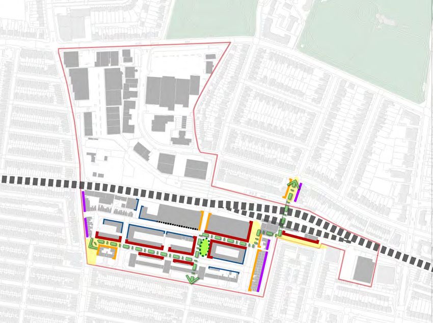
1 Introduction: Vision and purpose

Purpose                                             Vision - Hove Station Urban Quarter
1.1    This document is a ‘Supplementary            1.4    The vision of this document is to
Planning Document’ (SPD). All SPDs expand           transform the wider masterplan area into a
on higher level planning policy, providing          successful mixed-use Hove Station Urban
more specific guidance to help shape future         Quarter that provides for the following:
development. This SPD provides further detail       ■   good connections with surrounding
to help guide future development in the Hove            neighbourhoods and the wider city, with
Station Area, which is designated in Brighton           attractive pedestrian and cycle friendly
& Hove’s City Plan Part One at Policy DA6’              routes accessible by all;
Figure 1.1 opposite shows the extent of the DA6
                                                    ■   a broad range of employment uses, including
area. Policy DA6 aims to secure the long-term
                                                        facilities to support start-up and creative
regeneration of the area as an attractive and           industries;
sustainable mixed-use area.
                                                    ■   integration of new employment with a
1.2      In particular, this SPD focusses on            diverse range of other uses to create a lively,
the strategic allocation of the Conway Street           diverse urban quarter - these uses to include
Industrial Area and that part of DA6 to the south       housing of different types and tenures, along
of the railway, while highlighting opportunities        with retail, leisure and community facilities to
to knit together emerging development                   support day-to-day living;
proposals in the wider DA6 area in order to help    ■   a coherent, legible and attractive network of
facilitate the emergence of a successful urban          streets and spaces that include ‘greening’,
quarter that integrates and connects with local         space for play and prioritise the movements
neighbourhoods and the wider city.                      of pedestrians and cyclists over cars;
                                                    ■   a built environment that meets a wide range
Structure                                               of access needs, including those with visual
                                                        impairments;
1.3     This SPD is structured as follows:          ■   well-designed buildings that physically define
■   2 Planning policy context: providing an             and overlook the streets and spaces; and
    overview of policies which also apply to the    ■   a wide range of design features and facilities
    Hove Station Area.                                  that make a major contribution towards
■   3 Site and context analysis: setting out            the realisation of a carbon neutral and
    the area’s constraints and opportunities and        sustainable city.
    concluding with a set of specific objectives
    that any regeneration of the area should
    deliver.
■   4 Area wide strategy: providing principles
    for the area to the south of the railway with
    regard to public realm, design and land use,
    including an area.
■   5  Site specific opportunities: providing
    principles for the design of key sites,
    buildings, streets and spaces within the
    overall area.

                                                              Hove Station Area Supplementary Planning Document
2
Hove Park
                                                                                                     Hove Recreation Ground
                          Old Shoreham Road

                                                                                                    as
                                                                                                  V ill
                                                                                                  ar k
                                                                                              ve P
                                                                                            Ho
                           Sack ville Road

                                                      Conwa
                                                           y Stree
                                                                     t
                                                                                    illas

                                             Claren
                                                      don R
                                                                                  tone V

                                                              o ad
                                                                                 Golds

       DA6 Site Boundary

Figure 1.1: Hove Station Quarter Area

Figure 1.2: Hove Station Quarter Area

Hove Station Area Supplementary Planning Document
                                                                                                                              3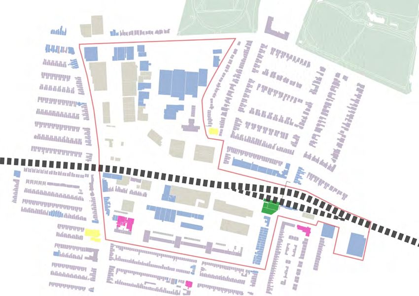
2 Planning policy context

Introduction
2.1     This section of the SPD provides an         2.4     Policy DA6 applies to the area defined
overview of the planning policy context in          in Figure 1.1 on page 3. The overall aim of the
relation to the following:                          policy is to secure the long-term regeneration
                                                    of the area and enable its development as a
■   the Brighton & Hove City Plan Part One          distinctive and sustainable mixed-use area
    (March 2016); and                               focussed on employment. The policy lists a
■   Supplementary Planning Guidance Note 15:        wide range of priorities focused on major public
    Tall Buildings (January 2004) and emerging      realm and townscape improvements; new
    Urban Design Framework Supplementary            and improved employment floorspace; public
    Planning Document (UDF SPD).                    open space and essential community services;
2.2   This SPD has also had regard to               new housing development; enhancing the
emerging policy in the following documents:         sustainable transport interchange at Hove
                                                    Station by improving the local walking and
■   the Hove Station Neighbourhood Plan; and        cycling network; improving ‘permeability’
■   the Brighton & Hove City Plan Part Two.         (pedestrian and cycle access); along with
                                                    provision of ‘green infrastructure’ (sustainable
                                                    planting and landscape design) and other
Adopted Planning Policy                             sustainability measures.
                                                    2.5     The policy includes a Strategic
Brighton & Hove City Plan Part One                  Allocation of the Conway Street Industrial
                                                    Area, to the south of the railway line. This
2.3     The BHCC City Plan Part One covers          area is identified in Figure 2.1 opposite. The
the Council’s area outside the South Downs          Strategic Allocation seeks the comprehensive
National Park and provides the overall strategic    redevelopment of the area to deliver more
and spatial vision for the city up to 2030. It is   effective use of the under-used land and
the key development plan document for the city      buildings. It requires and sets out minimum
that provides the policy framework for other        figures for the retention or replacement of
lower-tier documents including neighbourhood        existing employment floorspace with a shift
plans and SPDs. This includes more detailed         into high quality flexible office / business
advice on a range of matters that are relevant      floorspace, along with the provision of
for the Hove Station Area in the same way           residential dwellings and enhancements to the
they are relevant for other areas of this city,     streetscape.
and include policies around biodiversity
(CP10), urban design (CP12) and affordable          2.6     Policy DA6 states that guidance will be
housing (CP20). The City Plan identifies            prepared to promote and coordinate the mixed-
eight specific Development Areas which offer        use regeneration of the area. The emerging
significant capacity for new development close      Hove Station Neighbourhood Plan has been
to transport links and where new development        prepared by the local community (Hove Station
and/or regeneration will secure substantial         Neighbourhood Forum) to provide more
benefits for the city. The Hove Station Area        detailed planning policies for a Designated
is one of the development areas identified in       Neighbourhood Plan area which includes the
Policy DA6.                                         area of Policy DA6. This SPD now provides
                                                    further, more detailed guidance.

                                                            Hove Station Area Supplementary Planning Document
4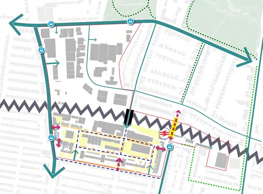
Figure 2.1: Policy DA6 allocation from Brighton & Hove City Plan Part One

2.7    As part of the process of producing this
SPD, the Council undertook consultation on
Issues and Options in early 2019. The Issues
and Options document asked a number of
questions based around:
■   the boundary extent of the masterplan;
■   the potential to capitalise on the location of
    the area in terms of sustainable transport;
■   provision of community facilities and a
    secure public realm;
■   the height of buildings;
■   meeting the needs of existing business;
■   development phasing and viability; and
■   flooding and the provision of energy.

Hove Station Area Supplementary Planning Document
                                                                            5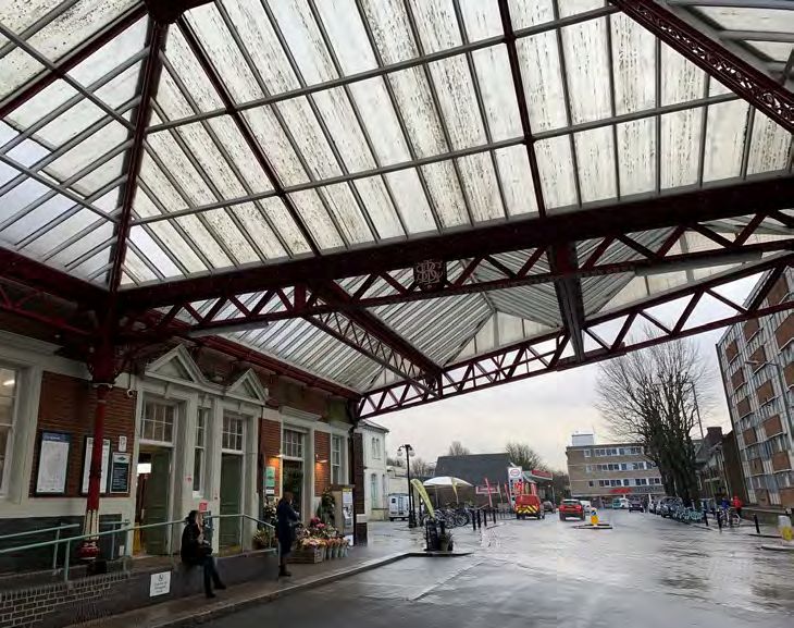
2.8    The following key principles were
                                                     Supplementary Planning Guidance Note 15:
established as a result of the consultation:
                                                     Tall Buildings
■   The core masterplan area is focussed on the
    DA6 land south of the railway.                   2.9      Supplementary Planning Guidance Note
                                                     15 on Tall Buildings is due to be replaced by
■   The needs of pedestrians and sustainable         the emerging Urban Design Framework (UDF)
    transport are a guiding principle.               SPD in 2021. Both documents identify areas
■   The SPD should identify locations for            of opportunities for tall buildings within the city
    community hubs.                                  and set out a list of planning and design issues
■   Illustrative concepts should be provided to      that must be addressed by any tall building
    identify the key priorities for public realm     proposals. The areas identified as suitable
    improvements.                                    for tall buildings generally have limited visual
■   The SPD should provide guidance on               impact on ‘sensitive’ views (conservation areas
    heights, density and massing of new              and other heritage and landscape assets – and
    buildings.                                       are close to public transport routes and local
                                                     shops and services.
■   The SPD should look at providing new good
    quality workspace that could meet the needs      2.10 The area ‘adjoining Hove Station’ is
    of existing and future businesses.               identified as having potential to accommodate
■   Advise on phasing and funding, particularly      ‘taller’ development. The emerging UDF SPD
    to ensure that elements such as open             sets out indicative boundaries and heights
    spaces and good quality public realm could       raging from mid-rise (up to 8 storeys) to very
    be delivered alongside new development,          tall (15 storeys or more) in a way that avoids
    whilst still considering planning applications   or minimises potential negative impacts on
    on their merits.                                 Hove Station and other surrounding heritage
                                                     assets and residential areas. Each individual
                                                     proposal would need to be assessed on its
                                                     own merits and with regard to the criteria set
                                                     out in these documents. Applications will be
                                                     expected to include detailed justification for
                                                     taller buildings including Townscape and Visual
                                                     Impact Assessments.
                                                     2.11 The Hove Station area spans both
                                                     sides of the rail corridor and extends west of
                                                     Hove Station to include an existing group of
                                                     tall residential buildings north of Clarendon
                                                     Road and the adjoining industrial areas. The
                                                     combination of existing tall buildings, good
                                                     transport links, and limited conservation
                                                     constraints provides the Hove Station area
                                                     with opportunities for tall building development.
                                                     These sites are at the heart of the masterplan
                                                     area.

                                                              Hove Station Area Supplementary Planning Document
6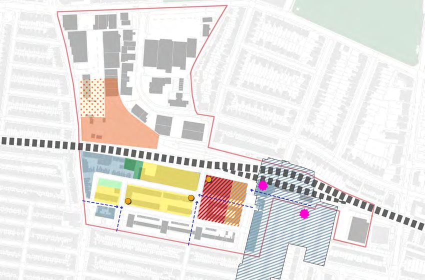
2.13 The overall aim of the Neighbourhood
Emerging Planning Policy                            Plan is to ‘facilitate the regeneration of the
                                                    Hove Station Neighbourhood Area in a way
                                                    which realises its potential by creating a vibrant
Hove Station Neighbourhood Plan                     and inclusive community, focused on a new
2.12 The decision by local residents to             Hove Station Quarter, as a great place to live,
establish the Hove Station Neighbourhood            work and relax’.
Forum with the right to develop a Hove Station      2.14 The Regulation 14 Draft Hove Station
Neighbourhood Plan emerged from the                 Neighbourhood Plan was published for public
growing awareness that the area around Hove         consultation in March 2019. It comprises two
Station was to be transformed by regeneration,      parts:
and the determination of the local community
to have some significant influence over the         ■   Part One: Policies and Consultation
planning process and its outcomes for the area.         Statement
The Forum was designated in December 2014,          ■   Part Two: Aspirations
and the designated area is shown in Figure 2.2      2.15 Part One includes draft policies which
below.                                              will form part of the statutory development
                                                    plan once the Neighbourhood Plan is formally
                                                    ‘made’. As such, these policies will be used
                                                    alongside the City Plan in determining planning
                                                    applications within the area.

Figure 2.2: Designated Neighbourhood Plan Area

Hove Station Area Supplementary Planning Document
                                                                                                         7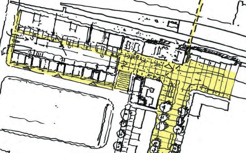
2.16 The Neighbourhood Plan Consultation           2.20 The making of the Plan requires the
Statement provides detailed evidence of the        following:
processes and outcomes of a four year period       ■   The Regulation 16 Consultation to be
of community engagement activities which               undertaken by the Council;
has involved the participation of over 1000
                                                   ■   examination by an independent Examiner;
residents in 17 public meetings and intervening
workshops and smaller meetings.                    ■   following the Examiner’s report and
                                                       recommendations, a Council decision
2.17 The Regulation 14 consultation on                 on whether the Plan should proceed to
the Draft Neighbourhood Plan Part One and              referendum; and
Part Two resulted in the active participation
                                                   ■   if successful at referendum, the
of over 100 local residents in this final
                                                       Neighbourhood Plan would then be
round of engagement, 24 written responses
                                                       ‘made’ by the Council and form part of the
from individuals and organisations and
                                                       Development Plan.
detailed comments from all relevant Council
departments.                                       2.21 This SPD has had regard to the policies
                                                   in the Draft Neighbourhood Plan Part One
2.18 The Consultation Statement itemises
                                                   and drawn on the ideas presented in Part
the amendments made to the Regulation 14
                                                   Two to provide detailed guidance for the
Draft. The Regulation 16 Draft Neighbourhood
                                                   implementation of both City Plan policies and
Plan will be submitted to the Council before the
                                                   Neighbourhood Plan policies.
end of 2020.
2.19 Part Two of the Neighbourhood Plan
does not include formal policies so will not
form part of the statutory plan. Rather it is an
aspirational document that brings together
ideas and project proposals that emerged
from the community engagement work
which underpinned the preparation of the
Neighbourhood Plan. These are presented
in the Urban Quarter Concept Master Plan
for DA6, with indicative project proposals for
specific locations and sites, together with
outline design schemes illustrating how the key
Neighbourhood Plan Community Hubs policy
could be implemented and a detailed case for
a comprehensive traffic management plan
for the whole of DA6 and adjacent residential
neighbourhoods.

                                                            Hove Station Area Supplementary Planning Document
8
2.24 The emerging Neighbourhood Plan
Brighton & Hove City Plan Part Two
had proposed that this land, together with
2.22 Part Two of the City Plan is intended to the adjacent Sackville Trading Estate should
support the implementation and delivery of City be allocated for comprehensive mixed-use
Plan Part One and to complement the strategic redevelopment to facilitate the creation of a
policy framework. It allocates additional new, integrated Hove Station Urban Quarter
development sites and includes detailed which would straddle the railway line. City Plan
development management policies. The draft Part Two proposes minimum quotas of 500
Plan was subject to public consultation in residential units and 6,000 sq.m employment
2018 and the Proposed Submission version (Class B1) floorspace for this area. Similarly,
of the Plan was approved for statutory pre- the emerging Neighbourhood Plan proposed
submission consultation by the Council in April the Royal Mail site (Hove Sorting Office, 88
2020. Denmark Villas) for residential development
2.23 Public consultation on the Proposed and City Plan Part 2 subsequently specified
Submission Plan was undertaken during 67 residential units along with employment
September/October 2020, The Plan will be uses under Policy H1 (Housing and Mixed Use
submitted for Examination in 2021. Part Two Sites).
includes changes in the DA6 area that had 2.25 Although City Plan Part Two is not yet
been identified in the emerging Neighbourhood formally adopted, this SPD has had regard to
Plan, most notably, the removal of the waste the Proposed Submission version.
management designation from the former
Sackville Coal Yard.
Hove Station Area Supplementary Planning Document
93 Site and context analysis
Introduction
3.1 This chapter provides an analysis of the within the masterplan area - one of these is
opportunities and constraints that will inform the deteriorated pedestrian footbridge and
the regeneration of the Hove Station Area. the other a road tunnel - neither of which are
These comprise: attractive or welcoming for pedestrians. The
Old Shoreham Road (A270) to the north is
■ Site context;
busy arterial road creating a further barrier
■ Land use and ownership; for pedestrians to navigate between the
■ Heritage; masterplan area and the park.
■ Movement and access; 3.5 The northern and western boundaries
■ Open space; of the site are formed by ‘A’ Roads, with the
A270 to the north and Sackville Road (A2023)
■ Building heights; and
to the west. There is a significant amount of
■ A summary of positive and negative ‘rat-running’ through the site area from drivers
influences. avoiding the junction of these two roads to the
3.2 The analysis in this section has led to north-west and instead using Fonthill Road /
the formulation of seven key objectives for the Goldstone Villas and Newton Road/ Wilbury
regeneration of the area. These expand upon Avenue .This fast-moving through-traffic results
and support the vision set out in Chapter 1, and in an environment that is hostile to pedestrians
provide the basis for the overall strategy and and cyclists.
detailed sites principles in Chapters 4 and 5. 3.6 While the majority of the Core
Masterplan Area is occupied by employment
uses, the surrounding area is largely
Site context residential, along with clusters of small shops
and some leisure and community facilities.
3.3 The Hove Station area is located to the
These are focused to the immediate north and
north of the central commercial area of Hove
south of Hove Station.
(focussed on George Street, Blatchington
Road and Church Road) which is located
around 800m to the south (around 10 minutes’
walk). The seafront is a further 600m to the
south (about 20 minutes’ walk from the station).
Walking to these destinations is straightforward
and pleasant along the gridded network of wide
streets.
3.4 The large and inviting green spaces
of Hove Park and Hove Recreation Ground
are some 10 minutes’ walk to the north of the
station. However, the east-west railway line
creates a significant barrier to all modes of
transport, there being only two crossing points
Hove Station Area Supplementary Planning Document
10N N
Hove Park
Hove Allotments
Hove Recreation
Ground
DA6
Old
Sho
reh
amR
Aldrington oad
Station
Hove Station
ad
ille Ro
Sackv
Brighto
Central Hove Station
Figure 3.1: Site context Plan
Figure 1.3: Aerial Location Plan
Hove Park
Hove
Old
Sho
reh
amR
oad
Figure 3.2: The Station pub is located next to Figure 3.3: Hove Park, located to the north of the
a cluster of small shops, south of the Railway DA6 area.
Station.
Hove Station Area Supplementary Planning Document
DA6 11Ownership and Land Use
3.7 The sites comprising the key landholdings would need to re-provide the
development opportunities in the masterplan company with a consolidated site of sufficient
area are in a range different ownerships. In size to meet their needs within the core
preparing the document discussions have masterplan area.
been held with the principal landowners C: Jewson’s Yard This site is owned and
to gain a good understanding of current operated by the builder’s merchant Jewson.
requirements and any aspirations for the The company has indicated that incorporating
future, to understand drivers for change – and its site into a wider regeneration scheme would
provide an understanding of the extent to which need to involve provision of an appropriate
these align with – and can be assisted by – the new site within reasonable proximity of Hove
masterplan in realising the desired changes Station, to continue to serve its existing market
for the area as set out in the City Plan and the in this part of the city.
emerging Neighbourhood Plan. The feedback
from engagement with these landowners is D: Crown Drinks The owner of the site has
summarised below. indicated their interest in the potential of the site
to play a role in the future regeneration of the
Core Masterplan Area area.
A: Hove Station Car Park The existing E: Decon Laboratories This site is owned
car park provides around 120 spaces and and operated by Decon Laboratories. The
is located on a higher level to the bus depot company has advised that an appropriate site
immediately to the south. Owners Network in the Burgess Hill/Haywards Heath area would
Rail are supportive with regard to the principle better meet the its locational needs.
of the car park site being developed as part
of regenerating the wider area, subject to F: Albert Works This site is owned and
business considerations and re-provision of managed by Harket Properties, providing
existing levels of parking provision in a location workspaces and a residential element. The
convenient for rail users. company is supportive in principle of its site
playing a role in the wider regeneration of the
B: Bus Depot These sites are owned and area, subject to a satisfactory land deal.
operated by Brighton & Hove Bus Company
(part of the Go-Ahead Group). The company G: Custom Pharmaceuticals This site is
has advised that the existing location of their owned by Matsim Properties. The existing
depot/workshop/staff within the Conway Street tenant is currently seeking to move to new
area is key (both now and in the future) to their accommodation in the city – but is likely to
operational needs in providing bus services require up to a further 5 years on its current site
across the city and beyond. However, their two as part of the staged transfer of operations.
existing buildings are in a poor state of repair H: Industrial House This site is owned by
and need to be redeveloped to provide up-to- Brighton & Hove City Council and provides
date bus depot facilities. In the short term, the workspace units for a range of companies. The
company is seeking to demolish its existing council is supportive of the site being part of the
buildings, re-provide workshop, office and wider comprehensive regeneration of the area.
staff facilities on part of its western landholding
I: The Agora This site, owned by Matsim
– and provide bus refuelling and/or parking
Properties, is a business centre providing
facilities on open areas across the remainder
accommodation to a range of companies.
of its sites. Any long-term regeneration of
the area affecting all or some of their existing
Hove Station Area Supplementary Planning Document
12D G
C
B A
E F B
H
K I J
K
Figure 3.4: Core site land ownership plan
N
Residential
Land Use and Facilities
des food Old Shoreham Road
Light industrial /
The current mix of land use on site comprises light
Industrial
industrial and retail / office space with some residential and
Office / retail (includes food
community uses.PThe presence of industrial units on site
and drink outlets)
has shaped much of the landscaping of the site as it stands
le Road
today. Warehouse style buildings set within large areas of car Place of worship
parking are prevalent across the area.
Sackvil
O The Clarendon Ellen Estate along the southern boundary Community
provides a gateway to the wider spread of residential
development that surrounds the site. Train Station
Key retail frontages exist along Goldstone Villas, framing a
key route between the station and central Hove, as can be
seen on the adjacent plan.
L
L
M
illas
N
tone V
Golds
Figure 3.5: Site and context land use plan
Figure 2.4: Land Use Plan
Hove Station Area Supplementary Planning Document
13J: 1-3 Ellen Street This site is currently North of the Railway
occupied by a low quality, two storey O: Sackville Trading Estate Planning
employment building. Planning permission approval has been secured by Moda Living
was granted on appeal on 19/12/18 for for a mixed-use scheme including 564 build-
residential development of up to 17 storeys to-rent residential flats, a 260 unit care facility,
(ref BH2016/02663). Following the sale of the offices, commercial and community facilities
site by previous owner Matsim Properties to (ref BH2019/03548).
Watkin Jones, a revised development scheme
of up to 18 storeys, including 218 build to rent P: Goldstone Retail Park. The owners of this
residential units, 1662 sq m commercial floor site have advised that they do not have any
space and 342 sq m of flexible commercial and plans for redevelopment in the near future.
community floor space, was granted planning 3.8 Outside the masterplan area, the locality
permission in October 2020. These approved is dominated by residential development in a
schemes provide a reference and material network of geometric gridded streets, dating
consideration for the character and height of from the late 19th and early 20th centuries.
future development proposals elsewhere within The scale of these becomes less ‘grand’
the tall buildings cluster from east to west. These areas are densely
K: Clarendon Ellen Estate Owned by developed, but often pleasant and tree-lined.
Brighton & Hove City Council, there has been To the east, the streets are often impressive
significant investment in the four towers in and wide. Within the housing areas to the west,
recent years. The Council is intending to there are few breaks for open space or parking,
engage with residents on how the rest of the and occasional terraces of local services and
Estate could be improved. shops.
L: Car Wash site This is located on land 3.9 Within the masterplan area, the scale is
owned by Network Rail who would be looking different, with an emphasis on light industrial
to improve station facilities as part of any wider units accommodating small and medium
regeneration in the area. The terms of its lease companies. Many of these units have parking
with the existing occupier of the site are not and servicing adjacent to the street, making the
known. environment feel disjointed and fragmented.
M: Petrol Station The owner and operator 3.10 Some of earlier residential terraces
of this site has not responded to requests for remain on Conway Street, and the gridded
meetings. street layout within the industrial area reflects
the pattern of former residential streets. North
N. Royal Mail Site The site is was identified of the railway line, the street pattern changes
in the emerging Neighbourhood Plan and to reflect the adjacent sweeping curved lines of
subsequently in the emerging City Plan Two the former coal yard and railway sidings.
for 67 residential units, potentially with some
employment development. 3.11 The bus depot has been within the
area for a century and may well have been
established close to the railway station for
practical and operational reasons. These
reasons remain – access to the station for
employees, access to the main service routes
and availability of space.
Hove Station Area Supplementary Planning Document
143.15 A further Listed Building, the Grade II
Heritage Ralli Memorial Hall, is within the Conservation
Area and just outside the Masterplan area.
3.12 The eastern part of the masterplan area Its setting is somewhat compromised by the
overlaps with the northern part of the Hove adjacent six storey residential building and
Station Conservation Area. Designated in the car wash and garage opposite. The Hall
1996, the area focuses on the listed station provides a range of community activities,
buildings and the long approach to them along and could form a positive contribution to an
Goldstone Villas. It is this relationship between upgraded area around the station.
the station and the connection to the town
centre that gives the area its special character.
3.13 There are two listed buildings within both
the study area and the Conservation Area, and
these are:
■ the Grade II Listed Station Buildings. The
current station building dates from around
1879, though the original station building
from 1865 is adjacent to it on Station
Approach. The listing includes the glazed
canopy to the south of the current station
building and the pedestrian footbridge over
the railway line; and
■ the Grade II Listed Former Ticket Office to
the north of the railway line, constructed at
the same time as the pedestrian footbridge.
3.14 The footbridge is in a poor state of repair
and - with limited views out - feels enclosed and
rather unwelcoming. It does not provide any
alternative means of crossing the railway line
for those who cannot use steps.
Conservation area
Listed Buildings
Figure 3.6: Hove Station Conservation Area and Listed Buildings
Above - Figure 3.7:
Hove Railway Station
and footbridge
Right - Figure 3.8:
Former Ticket
Office at Hove
Railway Station
Figure 3.9: Ralli
Memorial Hall
Hove Station Area Supplementary Planning Document
15Barrier to movement
The DA6 site is bound by two large strategic arterial routes
- railway line
that are important locally. These act as barriers to pedestrian
movement through the site to the surrounding areas as
Existing bus stop
pedestrian crossings are irregular. Old Shoreham Road in
❚ 2. The Wider Context and Site Analysis particular is difficult to cross as a pedestrian.
Vehicular route (larger
❚ A. Land
Movement anduse overview
access
Within the site itself there is a lack of north-south and
east-west links that would ease permeability and access to
thickness indicates a
more primary road)
Focus on area to south of railway
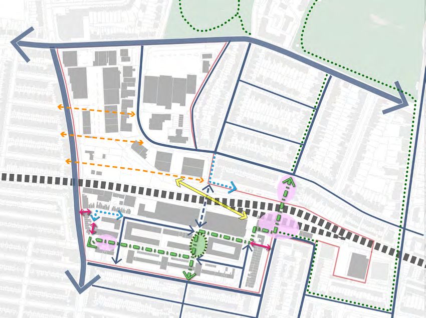
3.16 Providing for movement and
and through the area. A number of the pedestrian access
pointsaccess
are stepped, via
including the railway station bridge, and
Vehicular access point
therefore for cyclists and people with mobility difficulties the
sustainable travel modes, both within the Hove Access to commercial
site is particularly impermeable.
Station Area and to the wider City, will be key to car parks
The site is extremely well located in terms of access to public
the success of any redevelopment plans. Key
transport, due to its location adjacent to Hove train station ‘Rat run’ vehicular
issues that need to be addressed are:
and a number of bus stops served by local services located route
Regional Cycle
■ the Movement
severance caused by the around
and access railway line; of the site.
the perimeter DA6 Boundary
Network Route 82
The area to the south of the railway is more legible then the
■ the lack of clarity (or ‘legibility’) of pedestrian
area to the north, due to its retention ofBarrier to movement
a gridded street
The DA6 site is bound by two large strategic arterial routes Private car parking
access at the edges of the area;
that are important locally. These act as pattern.
- railway line
barriers to pedestrian O
■ rat-running by private
movement through vehicles
the site to through
the surrounding areas asthe
Existing bus stop On street parking for
pedestrian crossings are irregular. Old Shoreham Road in the public and permit
area (i.e. use of quieter roads to avoid busier,
particular is difficult to cross as a pedestrian. holders
more congested routes); Vehicular route (larger
Within the site itself there is a lack of north-south and thickness indicates a Pedestrian access point
■ enhancing pedestrian
east-west links that would easeaccess to the
permeability bus to
and access more primary road)
Stepped pedestrian
services at the Station and along Sackville
and through the area. A number of the pedestrian access
Vehicular access point access point
le Road
Road, which is currently limited by the flights
points are stepped, including the railway station bridge, and
therefore for cyclists and people with mobility difficulties the Railway bridge (pedestrian
of steps at both ends of Conway Street; and
site is particularly impermeable.
Access to commercial
step access)
car parks
streets and spaces wellbeing dominated
terms of accessby car
Sackvil
■ The site is extremely located in to public Tunnel under railway
parking and
transport, dueservice areas.
to its location adjacent to Hove train station ‘Rat run’ vehicular bridge (pedestrian, cyclist
and a number of bus stops served by local services located route and vehicular access)
around the perimeter of the site. Regional Cycle
Network Route 82 Figure 2
The area to the south of the railway is more legible then the
y
area to the north, due to its retention of a gridded street N
Private car parking
vement pattern.
On street parking for
Old Shoreham Road the public and permit
op
holders
e (larger Pedestrian access point
cates a
Stepped pedestrian
road)
access point
Hove Masterplan Review
ess point
le Road
12
Railway bridge (pedestrian
mmercial step access)
Tunnel under railway
Sackvil
ular
bridge (pedestrian, cyclist
and vehicular access)
e Figure 2.1: Movement Analysis Plan
e 82
rking
king for
d permit
cess point
strian
as
ne Vill
Hove Masterplan Review
e (pedestrian 12
to
Golds
ailway
trian, cyclist
access)
Figure 3.10:
Figure 2.1: Movement
Movement Analysis Analysis
Plan Plan
Hove Station Area Supplementary Planning Document
163.17 Severance: The railway is a significant 3.19 Rat-running: Private vehicles ‘rat
barrier to movement between the northern and run’ through the site from the south-east at
southern sides of the area both to pedestrians Clarendon Road, along Ellen Street to Fonthill
and other transport modes. Existing crossing Road and up to Old Shoreham Road. These
points are (from west to east): fast moving vehicles make the environment
■ Sackville Road, which offers the easiest hostile for pedestrians and cyclists.
connection, but is heavily trafficked. 3.20 Lack of bus stops: There are bus
■ Fonthill Road / Goldstone Street, which stops outside the Rail Station and on Sackville
passes beneath the railway. The road is used Road. However, access to these from the
as a rat-run to avoid Sackville Road and Conway Street Industrial Area is via steps (both
is unappealing to pedestrians and cyclists on its eastern and western sides) and there is
on account of its dark environment, narrow currently no bus service serving this core area.
footways and length. With future intensification from development
■ The pedestrian footbridge at the station,
of the core area, improved access to bus
which does not incorporate a lift, so is not facilities would be beneficial. Any changes to
accessible to all. It is in a poor state of repair routes would need consideration of the impact
and does not feel pleasant or safe to use. on other services and be subject to early
discussion with commercial operators.
3.18 Lack of clarity: There are four main
‘gateways’ to the area for pedestrians, but 3.21 Dominance of car parking and
all suffer from a lack of clarity (legibility) and servicing: Much of the Conway Street area
accessibility due to level changes: is dominated by parking, be it off-street within
business curtilages, or on-street. This adds
■ The Salvation Army steps up from Sackville
to the lack of legibility within the area; service
Road to Conway Street. These steps
yards at the back of premises often face public
do not have the appearance of a ‘public’
thoroughfare (although they can be used streets.
by anyone) and have gates that are locked
every night.
■ Steps up to Conway Street from the public
open space outside the Honeycroft Centre.
These are tucked away behind buildings on
Sackville Road. They do not look inviting
and make no provision for disabled access.
■ Goldstone Street / Fonthill Road provides
a strong north-south link through the site
connecting to the wider area. However, at
the site’s southern ‘gateway’, it passes under
the low-rise dwellings in the Clarendon Ellen
Estate and does not appear visually as a
welcoming or important connection.
■ The steps down from Goldstone Villas next
to The Station Pub are not visually apparent
and are easy to miss.
Hove Station Area Supplementary Planning Document
17improved public realm. The area is within a
Open space Groundwater Source Protection Zone (GSPZ)
and therefore any SuDS would need to be
3.22 Though there are extensive green appropriately designed to avoid contamination
spaces to the north (principally Hove Park, of the local water supply (see the Sustainable
north of Old Shoreham Road) there is very Drainage SPD).
little green space within the masterplan
area; instead it is dominated by hard tarmac 3.24 There is potential for creating two
surfaces. There are some small green areas distinctive and welcoming ’entry points’ that
within the Clarendon Ellen Estate. However, could help draw people into the area - through
these spaces appear to be neither public nor improvements to two existing spaces: the
private in nature, and do not seem to offer any space outside the Honeycroft Centre and the
functional amenity value, beyond providing very setting of the listed Hove station buildings.
limited amenity space for estate residents and Neither of these spaces perform this role well
a buffer zone between the flats and the public at present.
highway. ■ the station setting is dominated by a very
wide road and unsightly car-related uses in
3.23 The dominance of hard surfacing and
the form of a car wash and petrol station; and
the southward sloping topography means that
the area contributes to surface water runoff that ■ the space outside the Honeycroft Centre is a
can become an issue in areas further south bleak space that, with the absence of good
towards the coast, during times of exceptionally overlooking from adjacent buildings, fails
intense rainfall. There is an opportunity to slow to fulfil its potential as an attractive people-
down flows during rainfall by incorporating friendly public space or in facilitating a range
SuDS storage features into the design of an of informal recreational amenities.
N
DA6 Boundary
Open Space
Old Shoreham Road
g for the The plan shows that within the confines of the site, the Private car park
holders majority of the external space is used for highways, car
parking and service yards. On-street parking for the
ce
Car parking (both within car parks and on-street) is dominant public and permit holders
le Road
throughout the site, which has a negative impact on the
n space Service yard space
streetscape throughout the site, both in car parks and on
street.
Sackvil
ce Inaccessible green space
Some public green space exists, but this is generally around
the perimeters of buildings and unusable. The open space to
the south of the Clarendon Ellen Estate is underused as well Public green space
as creating severance between Clarendon Road and the
building frontage, preventing an active frontage here. Private gardens
Hard landscape
as
ne Vill
to
Golds
Figure 3.11: Open Space Analysis Plan
Figure 2.2: Open Space Analysis Plan
Hove Station Area Supplementary Planning Document
183.27 As discussed, the area is undergoing
Building heights change. As an identified tall buildings area,
significant changes to the townscape can be
3.25 Buildings in the wider neighbourhoods expected in the future. Three schemes are
surrounding the masterplan area are typically already in the pipeline for development of
of a residential scale, 2 to 3 storeys in height. substantially greater scale than the existing:
The residential terraces of Hove are grand to
■ the Moda Living proposal that has been
the east of Goldstone Villas, and denser and
granted planning permission for the
smaller to the west. The industrial buildings
redvelopment of the Sackville Trading
within the employment areas are of a larger
Estate and the former Goods Yard. which
scale, but rarely above two storeys.
includes buildings up to 15 storeys in height;
3.26 There are exceptions to this general ■ the KAP proposal on Newtown Road
scale, notably the five 10-storey towers within includes buildings up to 11 storeys, and
the Clarendon Ellen Estate. Other taller
■ the Watkin Jones proposal on the 1-3 Ellen
buildings include the 6-storey residential block
Street site on Conway Street has been
across from the station entrance and the new
granted permission for up to 18 storeys.
apartment block recently developed by Hyde
(New Wave) on Newtown Road. The Dubarry 3.28 There is potential for the spatial
building on the north side of the railwayB.
hasExisting
an ❚ accessbetween
relationship and movement
tall buildings to realise a
imposing presence, being of four storeys with a distinctive townscape, particularly in clustering
large floor to ceiling height. close to the station to create an overall
landmark within the wider townscape – while
of course - being mindful of key heritage
considerations.
1.5 storeys
N
3 storeys
1 - 1.5 storeys
Building Heights
Old Shoreham Road
oreys
Much of the site is dominated by warehouse style light 2 - 3 storeys
oreys industrial units, which are characteristically 1-3 storeys tall.
The majority of the surrounding context comprises 2-3 4 storeys
le Road
oreys
storey Victorian terrace housing. The Clarendon Ellen Estate
to the south provides the tallest point on site, at 10 storeys, 5 storeys
toreys
with the recent New Wave development to the north of the
Sackvil
railway also providing some height at 6 storeys. The current
6 storeys
townscape is illegible in terms of providing definition to the
key node of the train station due to the distribution of the
10 storeys
taller elements. The opportunity exists to create a clear
destination through the use of carefully designed clusters of
taller buildings.
illas
tone V
Golds
Figure 3.12: Building Heights Plan
Figure 2.3: Building Heights Plan
Hove Station Area Supplementary Planning Document
19Positive and negative influences
3.29 The presence of the railway station and There is a major opportunity for regeneration of
its role in generating the movement of people the area to improve connections, particularly:
to and from this part of the city provides a key ■ at the north-eastern corner, where the
potential catalyst for the area’s regeneration. potential redevelopment of the Network Rail
There has been significantly increased Car Park and eastern Bus Depot could open-
investment in the existing small independent up direct access to the area from the Station,
businesses and shops clustered around the and supplement the existing stepped access
station which has provided enhanced vibrancy from Goldstone Villas; and
to the station’s southern approach. ■ at the south-western corner, where
3.30 There are some further existing redevelopment of the Honeycroft Centre
elements that contribute positively to the built could provide for a really high-quality public
environment – the listed station buildings, space with direct, welcoming connections
nearby buildings such as the Dubarry building into the area for pedestrians and cyclists.
(Hove Business Centre) and the Ralli Memorial 3.33 Since 2015 the submission of
Hall. However, the majority of the masterplan successive planning applications for
area is occupied by low quality employment major new developments such as at Hyde
buildings with largely ‘blank’ frontages, creating Newtown Road, 1-3 Ellen Street, KAP and
a relatively hostile pedestrian environment. the Sackville Road Trading Estate/Coal
3.31 The area contains a range of different Yard have demonstrated sustained market
employment uses, from start-up space for pressure for the transformation of the area by
creative businesses through to larger scale very high density development. To achieve
independent operations. Ensuring that the planning policy aims, it is important that the
area retains a significant employment function, management of planning applications takes
shifting to a more office based economy, is key. a comprehensive, coordinated approach
The creation of a mixed-use employment and to the area – reflecting the objectives of the
residential neighbourhood will make best use of City Plan and the Neighbourhood Plan. In
the area’s proximity to the Station and its ability January 2019, the council declared a climate
to support a diverse range of ancillary uses emergency and put in place a commitment
(such as cafés and shops). The delivery of to make Brighton & Hove carbon neutral by
new employment floorspace is a fundamental 2030. The redevelopment of this area offers a
requirement of City Plan Policy DA6. The area unique opportunity to meet this ambition and
also offers potential to deliver substantial new provide an exemplar of what can be achieved
housing up to and above the minimum housing when carbon neutrality is at the core of the
figures set in Policy DA6. masterplan.
3.32 New developments need to provide 3.34 The principles set out in Chapters 4
solutions that overcome the existing poor and 5 of this SPD draw on and enhance those
connectivity to the wider area – and the poor which were developed for the above planning
quality of the streets and spaces within it. documents and will help meet the city’s climate
challenge. They provide a detailed coordinating
framework.
Hove Station Area Supplementary Planning Document
20Figures 3.13: Existing Positive Influences
Figures 3.14: Existing Negative Influences
Hove Station Area Supplementary Planning Document
213.35 Table 3.1 below sets out seven specific
objectives derived from the analysis of the
area. These objectives have underpinned the
coordinating framework.
Objectives
1 Improve bus depot Discussions with the bus company have established that the
current location of the bus depot is fundamental in meeting its
The bus depot needs to be
operational requirements. A range of potential future changes
improved within the DA6 area,
relating to an expanding fleet, the fuelling requirements and
and needs scope to expand.
other operational issues mean that the ageing bus depot
needs redeveloping. The current buildings need upgrading.
The bus company’s preference is to remain in its current
location. However, there may be potential to partially relocate
and reconfigure the company’s existing sites as part of a land
assembly exercise shifting the bus facilities westwards onto
adjacent land within the core masterplan area.
2 Unlock station sites: Connections into the area from the east are limited. The
integrated development of the Network Rail Car Park and
Provide the necessary drivers
Bus Depot site east of Fonthill Road would provide the means
for key sites around the station
to unlock the area as a whole, providing a significant level of
itself to become available for
development and new links into and through the area to and
development.
from the station. Such redevelopment could act as a catalyst for
further development on other sites within the core masterplan
area.
3 Repurpose Fonthill Road: The potential regeneration of the Conway Street area is currently
compromised by the existing use of Fonthill Road as a rat-run.
Fonthill Road needs to become
There is an opportunity to both reduce the number of vehicles
a pedestrian and cyclist friendly
using this link and to create a greatly improved environment for
link, and vehicle movements
pedestrians and cyclists.
through the area must be
limited.
4 Maintain station parking: Discussions with Network Rail have indicated that the current
level of parking provision serving the station should be
The level of dedicated parking
accommodated in any redevelopment involving the existing car
provision serving the station
park site. The location of replacement parking should maintain
should be maintained.
convenient access for rail travellers. The Neighbourhood Plan
promotes the long-term possibility of centralised car parking
facilities combining the station parking with parking for local
residents, commuters and visitors if a suitable site can be found.
Table 3.1: Seven specific objectives derived from the analysis of the area
Hove Station Area Supplementary Planning Document
22Objectives (continued)
5 Enhance station setting: The area south of the railway line has the potential to provide (i)
a much improved setting for the listed station buildings; and (ii) a
The setting of the station /
public realm that provides more space for pedestrians. cyclists
Station Approach should be
and users of public transport and reduced space for vehicles.
enhanced.
Enhancement of the station setting is a key component of the
Neighbourhood Plan proposal for a Hove Station Community
Hub, which is focused on the improvement of the immediate
environs of the station.
6 Improve station accessibility: While the south side of the station forms the main access point
for passengers and is relatively accessible, the vehicular-
Improve station accessibility:
pedestrian cycle conflicts should be minimised. The north side of
In the context of improving the railway has completely inadequate access via the footbridge,
non-vehicular accessibility to creating access problems for a range of users (and potential
the station, east-west routes users) including people with disabilities and elderly people with
through the Conway Street heavy shopping bags or luggage.
industrial area should be
In the short term, the physical condition of the bridge (which
improved and the northern
is a listed structure) should be improved, It should also offer
access to the station also
more attractive alternatives for accessing the southern entrance
enhanced.
by improving connectivity from the north and west through
the Conway Street area, from Fonthill Road and across to
the Sackville Trading area as it is redeveloped. In the longer
term an evaluation of the options should be undertaken of
lift access to the bridge at both ends or extending to Hove
Park villas the north-south tunnel connecting the platforms.
Improving accessibility to the station is a key component of the
Neighbourhood Plan proposal for a Hove Station Community
Hub.
7 Improve Honeycroft: Clarendon Ellen Estate currently provides a social hub on the
ground floor of the western tower (the Honeycroft Centre) which
The Honeycroft community hub
includes a nursery, space for community events and training,
at the Clarendon Ellen Estate
and space for hire, There is also a range of other community
should be improved.
uses in the two-storey building. The public open space in front
of the centre and pedestrian access into the core masterplan
area at this point are both poor in terms of quality and legibility.
There is potential to redevelop while greatly improving this area,
re-providing community facilities along with additional homes
with a reconfigured public open space and legible routes to
better connect into the surrounding area. The improvement
of the existing community facilities and local open space with
the associated redevelopment of the Decon building are core
elements of the Neighbourhood Plan proposal for the Sackville
Road-Conway Street Community Hub.
Hove Station Area Supplementary Planning Document
234 Area wide strategy
Movement: routes and connectivity
Introduction
4.3 Figure 4.1 opposite sets out the overall
4.1 This chapter provides a coordinating strategy for movement, showing how routes
framework for all new development within the and connectivity will be improved in the area.
masterplan area. All planning applications The key principles are:
and projects are expected to accord with the ■ Reduce the volume and speed of vehicular
principles in relation to the following: traffic by introducing controls at the Fonthill
■ Public Realm Strategy Road tunnel under the railway line. Design
- Movement: routes and connectivity the route through the tunnel to provide
- Street types and spaces greater space for pedestrians and cyclists.
Incorporate lighting, materials and public art
- New and improved areas of public space to make the space feel more welcoming and
- Sustainability Principles engaging to non-car users.
■ Layout Principles ■ Extend this north-south route through to
- Key frontages and edges Clarendon Road, creating a green link for all
- Key views, landmarks, and opportunities pedestrians (including children and young
for height people) between Conway Street and Ellen
Street, along with an improved pedestrian /
■ Land use principles
cycle link through the Clarendon Ellen Estate
to Clarendon Road.
Redevelop the station car park and eastern
Public realm strategy ■
Bus Depot sites to provide mixed-use
4.2 Figure 4.1 opposite sets out the overall development incorporating a strong, positive
strategy for movement, showing how routes pedestrian connection from the station level
and connectivity will be improved in the area. to Conway Street.
The key principles are: ■ Improve the existing pedestrian footbridge
over the railway line, providing lifts as well
■ movement: routes and connectivity;
as stairs, being mindful of its Grade II Listed
■ street types; and status.
■ integrating sustainability principles. ■ Consider opportunity to provide for limited
additional parking in a multi-storey car park
to serve the wider development in the core
masterplan area.
■ Redevelop the Honeycroft Centre and
associated community facilities, providing
a new ‘gateway’ space and a direct and
welcoming pedestrian / cycle connection
through to Ellen Street.
■ Create a clear pedestrian-friendly east-
west route connecting Sackville Road to the
station.
Hove Station Area Supplementary Planning Document
24N
Hove Park
Old Shoreham Road Hove Recreation Ground
i llas
rk V
e Pa
Hov
Sack ville Road
Conwa Hove
y Stree Station
t
illas
Claren
don R
tone V
o ad
Golds
Figure 4.1: Movement Strategy
■ Simplify vehicular routes, ensuring that
Access only
vehicular route DA6 Boundary appropriate access to existing and future
businesses to ensure they can continue
Improved pedestrian
Vehicular route to operate successfully. This includes
links
providing for bus access to existing and
Regional cycle route
Priority flow future Bus Depot facilities.
vehicular route
■ Ensure that any future redevelopment of the
Indicative strategic
Newtown Road employment area provides
Key pedestrian / pedestrian / cycle direct pedestrian and cycle connections
cycle priority route links to east-west routes provided as part of the
Focal green space redevelopment of the Sackville Road Trading
Potential pedestrian
/ cycle bridge
Estate.
over railway line Key area of
(illustrative alignment) public realm
Hove Station Area Supplementary Planning Document
25Integrating sustainability
Street types
4.6 Sustainability measures should be
4.4 A key aim of the public realm strategy
integrated into the design of the public realm.
is to make the Hove Station Area more
These should include:
welcoming to pedestrians and cyclists. The
area is currently dominated by motor vehicles ■ incorporating planting, vegetation and
and isn’t conducive to walking or cycling. The water features (‘green’/’blue’ infrastructure)
aim of the public realm strategy is to prioritise including sustainable urban elements
pedestrian and cycle movements. To achieve (SuDS) to slow-down the rate of surface
this, the public realm strategy proposes two water run-off and reduce contaminants
distinct street types: entering the groundwater resource (see
SPD16 Sustainable Drainage);
■ Vehicular routes, with the traditional
demarcation of carriageway and footways ■ ensuring that any future heat network in the
on either side. Cyclists are accommodated area can be accommodated within streets
on-street. Greening of these streets is and spaces; and ensuring that space is
not normally an essential requirement, safeguarded within the public realm and
though opportunities to enhance green coordinated with other services to allow the
infrastructure should be sought where installation of an area-wide low-carbon heat
possible. Streets that buses are expected network, including links to other adjacent
to use should be designed appropriately to areas to support the development of a wider
allow unobstructed free-flow operation of interconnected area wide network;
buses in both directions. ■ providing green infrastructure to help
■ Pedestrian / cycle priority routes, which enhance biodiversity, (e.g. wildlife-friendly
either wholly or partly exclude vehicles and planting, green walls or roofs, hanging
provide slow speed design. Green/blue gardens, bird boxes, bee bricks etc.),
infrastructure in the form of pocket parks, improving air quality, providing shading and
water management/SuDS and / or street improving the well-being of people who live
trees should be an integral element of the and work in the area, including through the
design of these streets. provision of local food growing opportunities;
■ food growing (e.g. edible landscaping/fruit
4.5 Chapter 5 provides guidance for specific
trees etc.);
locations within the overall movement strategy.
■ car-free developments where possible and
■ Trees must be an integral part of the design
an environment conducive to pedestrians
of these streets.
and cyclists;
■ explore opportunity for a freight logistics/
‘last mile’ hub to north of railway;
■ provide for/retain Blue Badge parking;
Hove Station Area Supplementary Planning Document
26You can also read