Cultural Heritage Impact Statement - Ottawa Public Library/Library and Archives Canada Joint Facility 555 Albert Street, Ottawa, ON - City of Ottawa
←
→
Page content transcription
If your browser does not render page correctly, please read the page content below
Cultural Heritage Impact Statement
    Ottawa Public Library/Library and Archives Canada
                       Joint Facility
              555 Albert Street, Ottawa, ON

Prepared for:
Ralph Wiesbrock, OAA, FRAIC, LEED AP
Partner / Principal
KWC Architects Inc.
383 Parkdale Avenue, suite 201
Ottawa, Ontario K1Y 4R4
T: 613-238-2117 ext. 225    C: 613-728-5800
E: rwiesbrock@kwc-arch.com
Submitted by:
Julie Harris, CAHP, Principal & Heritage Specialist, Contentworks Inc.
E: jharris@contentworks.ca T: 613 730-4059

Date:
17 June 2020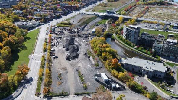
Table of Contents
1       INTRODUCTION ................................................................................................................................... 2
    1.1         ABOUT THE CHIS ........................................................................................................................................... 2
    1.2         SOURCES .......................................................................................................................................................... 2
    1.3         DEVELOPMENT SITE ...................................................................................................................................... 3
2       HERITAGE RESOURCE DESCRIPTIONS AND HISTORIES ........................................................ 9
    2.1         FORMAL MUNICIPAL RECOGNITIONS .......................................................................................................... 9
    2.2         OTHER HERITAGE ....................................................................................................................................... 18
3       PROPOSED DEVELOPMENT .......................................................................................................... 19
    3.1         DESIGNERS ................................................................................................................................................... 19
    3.2         OVERVIEW OF THE BUILDING PROGRAM ................................................................................................ 19
    3.3         ARCHITECTURAL DESIGN AND STYLE ...................................................................................................... 22
    3.4         OUTDOOR SPACES AND LANDSCAPE ........................................................................................................ 23
    3.5         CIRCULATION (EXTERIOR) ........................................................................................................................ 23
    3.6         STREETSCAPES AND VIEWS ....................................................................................................................... 24
4       IMPACT OF PROPOSED DEVELOPMENT................................................................................... 27
    4.1         DESCRIPTION OF POTENTIAL IMPACTS ................................................................................................... 27
    4.2         SUMMARY OF POSITIVE HERITAGE IMPACTS (CHIS GUIDELINES) .................................................... 29
    4.3         ADVERSE HERITAGE IMPACTS (CHIS GUIDELINES) .............................................................................. 30
    4.4         CONSIDERATION OF THE STANDARDS AND GUIDELINES ...................................................................... 31
    4.5         CONSIDERATION OF THE PROVINCIAL POLICY STATEMENT ................................................................ 32
5       ALTERNATIVES, MITIGATION AND CONCLUSION................................................................. 33
    5.1         ALTERNATIVES ............................................................................................................................................ 33
    5.2         MITIGATION ................................................................................................................................................. 33
    5.3         CONCLUSION................................................................................................................................................. 34
APPENDIX 1: HERITAGE STATEMENTS AND OBJECTIVES.......................................................... 35
    DRAFT STATEMENT OF CULTURAL HERITAGE VALUE FOR THE OTTAWA WATER WORKS, LEBRETON
    FLATS – BYLAW 22-82 ............................................................................................................................................ 35
    STATEMENT OF CULTURAL HERITAGE VALUE- CITY WATERWORKS BUILDING AND AQUEDUCT, 10 FLEET
    STREET (1991; BYLAW 22-82) ............................................................................................................................ 39
    STATEMENT OF REASON FOR DESIGNATION- 504 ALBERT STREET ................................................................ 39
    STATEMENT OF REASON FOR DESIGNATION- 494 ALBERT STREET ................................................................ 40
    STATEMENT OF CULTURAL HERITAGE VALUE- POOLEY’S BRIDGE, 9 FLEET STREET................................... 40
    OBJECTIVES OF THE LORNE AVENUE HERITAGE CONSERVATION DISTRICT ................................................... 40

                                                                                                                                         17 June 2020
                                                                                                           CHIS – OPL-LAC Joint Facility #: 20-CW-555
                                                                                                                                                Page 1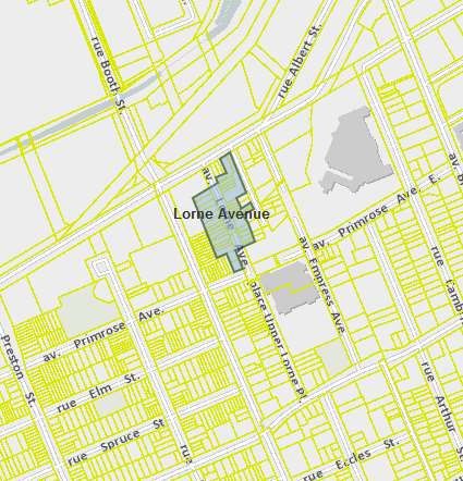
1 Introduction
1.1 About the CHIS
The City of Ottawa has requested a Cultural Heritage Impact Statement (CHIS) prepared by a
qualified heritage consultant to examine potential impacts from the construction of a new
library as a joint facility for the City of Ottawa’s Ottawa Public Library and the federal Library
and Archives Canada. The property is owned by the City of Ottawa.
Section 4.6.1 of the City of Ottawa Official Plan has policies outlining when a CHIS may be
required and provides evaluation requirements when a development has potential to:
    •    Adversely impact the cultural heritage value of properties designated under Part IV of
         the Ontario Heritage Act (OHA); and
    •    Adversely impact the cultural heritage value of districts designated under Part V of the
         OHA.
The CHIS has been requested by the City to address potential impacts from the proposed
development at 555 Albert Street on nearby heritage properties. The set of heritage
properties consists of nine residences, an apartment building, the complex of Ottawa
Waterworks structures (building, bridges and aqueduct), the Lorne Avenue Heritage
Conservation District (HCD) and the Cathedral Hill HCD. The Ottawa Waterworks building is
also subject to a heritage easement agreement with the Ontario Heritage Trust. The City also
requested that the CHIS consider how features will be contributing to a better understanding
and appreciation of the area’s history and Indigenous (Anishinabe Algonquin) context.
The CHIS is focused exclusively on potential impacts from the project to build a new library
and archives facility. A separate project to redesign Albert Street is also in progress.
Cumulative impacts from the two projects on heritage values and properties are not
considered in this CHIS.
The CHIS is authored by Julie Harris, Contentworks Inc., CAHP.1

1.2 Sources
In addition to sources mentioned in footnotes and three site visits undertaken by the author
in May 2020, the following materials were used to prepare the CHIS:
    •    Barry Padolsky Architect Ltd. et al. Ottawa Waterworks: The Aqueduct & Bridges at
         LeBreton Flats. Prepared for Regional Municipality of Ottawa-Carleton, City of Ottawa
         and the National Capital Commission. 1992.
    •    City of Ottawa, Lorne Avenue Heritage Conservation District Study, 2006.
    •    City of Ottawa, Pre-consultation Planning Department notes for 555 Albert Street,
         [2020], File PC2020-0106.
    •    Contentworks Inc. and Barry Padolsky Associates Inc. Cultural Heritage Evaluation,
         Old Booth Street Bridge, 9 Fleet Street, Ottawa, ON. July 2019.

1Julie Harris, President, Contentworks Inc., is a Professional Member of the Canadian Association of Heritage
Professionals. She has over 30 years of experience in heritage evaluation and historical research. She has been
qualified as a witness in the field of heritage evaluation for the purposes of an OMB; served as a provincial
appointee to the Conservation Review Board of Ontario; and conducted architectural histories for hundreds of
buildings and landscapes for various government clients in Ontario and other parts of Canada.

                                                                                                   17 June 2020
                                                                     CHIS – OPL-LAC Joint Facility #: 20-CW-555
                                                                                                          Page 2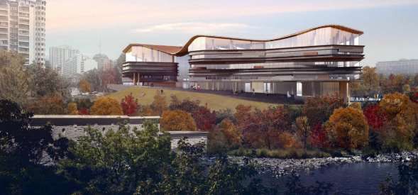
•   Diamond Schmitt Architects/KWC Architects Inc. Building-Architectural Plan, January
       2020.
   •   Diamond Schmitt Architects/PPS Studio. Landscape plans, January 2020.
   •   Diamond Schmitt Architects/KWC Architects Inc., [Shadow study for 555 Albert
       Street.] [May 2020].
   •   Diamond Schmitt Architects/KWC Architects Inc., Ottawa Public Library/Library &
       Archives Canada Joint Facility, JDRP Report, 26 February 2020.
   •   Fotenn Planning + Design, Planning Rationale + Design Brief in support of the Official
       Plan Amendment and Zoning By-law Amendment of 557 Wellington Street, 584/587
       Wellington Street and 550 Albert Street, 26 March 2018.
   •   Jenkins, Phil. An Acre of Time. Chelsea, Quebec: Chelsea Books, 2008.
   •   National Capital Commission, Ottawa Public Library (OPL)/Library and Archives
       Canada (LAC) – Joint Facility Schematic Design and Public Engagement, ACPDR, May
       16-17, 2020. Presentation.
   •   National Capital Commission, LeBreton Flats Heritage Statement (Draft), 2014.
   •   Ontario Heritage Trust, “Fleet Street Pumping Station,” online at
       www.heritagetrust.on.ca/en/properties/fleet-street-pumping-station. The Fleet
       Street Pumping Station building is subject to an Ontario Heritage Trust heritage
       easement secured with the City of Ottawa in 1983.
   •   Past Recovery Archaeological Services, Stage 1 Archaeological Assessment of LeBreton
       South, Parts Lots 39 & 40, Concession A, Ottawa Front. Prepared for the National
       Capital Commission, 2012.

1.2.1 Contact Information
       Ralph Wiesbrock, OAA, FRAIC, LEED AP
       Partner / Principal
       KWC Architects Inc.
       383 Parkdale Avenue, suite 201
       Ottawa, Ontario K1Y 4R4
       T: 613-238-2117 ext. 225    C: 613-728-5800
       E: rwiesbrock@kwc-arch.com

1.3 Development Site
1.3.1 Legal Descriptions
The project site is almost the entire area of lot PIN 04112. It is bounded by Albert Street on
the south, Commissioner Street on the east, and the former street alignments of Wellington
Street and Brickhill Street on the north and west. The owner is the City of Ottawa.

1.3.2 Context
The development site is located within a neighbourhood that contains a lively mix of older
homes, new mid- and high-rise residential buildings, and institutional structures. It is located
on the edge of Ottawa’s downtown, approximately 1.5 kilometres from Parliament Hill, in the
LeBreton Flats neighbourhood, adjacent to the NCC LeBreton Flats redevelopment site. As an
empty site, it has become almost invisible in the landscape of Ottawa, but with development it
will become a terminating vista when traveling west on Albert Street from downtown and
north on Bronson Avenue. The building will also rise above the Ottawa Waterworks
pumphouse and the Old Aqueduct and serve as an important landmark on the Confederation

                                                                                        17 June 2020
                                                          CHIS – OPL-LAC Joint Facility #: 20-CW-555
                                                                                               Page 3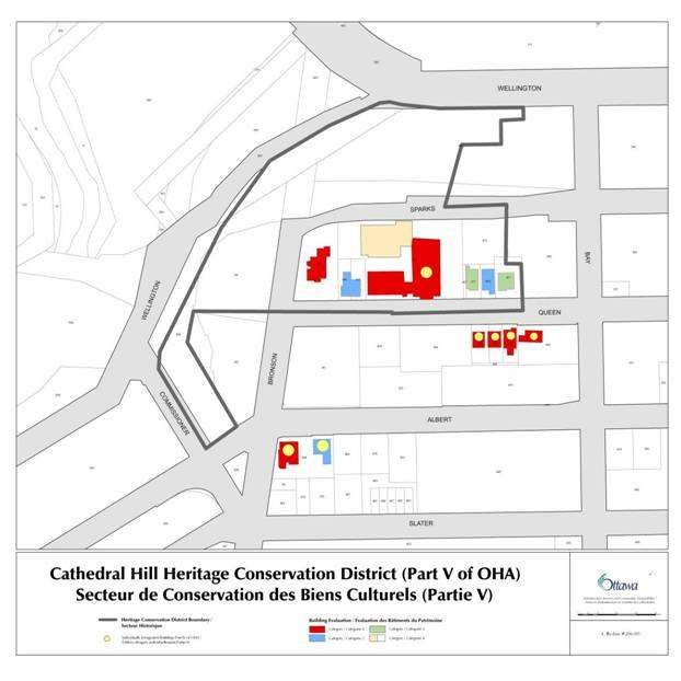
LRT line.
The neighbourhood to the south of the subject property is largely residential, separated from
the institutional St. Vincent hospital buildings that sit on the ridge that helps define the limits
of LeBreton Flats. Most of the buildings are two storeys in height with brick cladding and are
similar in scale to the homes that were demolished for the clearing of LeBreton Flats in the
1960s.

Figure 1: Drone view of the development site, October 2019. The Ottawa Water Works building is marked with an
arrow. Source: City of Ottawa with annotation by Contentworks.

1.3.3 History of the Site and LeBreton Flats Context
The property at 555 Albert Street sits on a terrace that is midway in elevation between Nanny
Goat Hill (the escarpment north of Somerset Street) and the lower part of LeBreton Flats. The
entire flats area, including the subject property, exhibits characteristics (vegetated bluffs, co-
location next to a major waterway, wetlands that would have existed in previous, centuries,
etc.) that would have made in attractive for occupation by Anishnabe Algonquin People.2 .
Permanent settler occupation of LeBreton Flats began in 1818 with the establishment of
Richmond’s Landing. The area was surveyed and sold shortly thereafter, including lots to John
LeBreton, after whom the area is named. By 1831, roads led from the flats east to Upper
Bytown and west to Richmond. The road east was roughly in line with Wellington Street,
which passed directly to the north of the subject property at 555 Albert Street. Development
of the flats was continuous in the last half of the 19th century to support the timber trade and
related industries that benefitted from access to the Ottawa River for transportation and
power.
The Great Fire of 1900 destroyed most of LeBreton Flats but the fire was stopped from going
up the hill towards Bronson Avenue along Wellington and Albert streets by a bucket brigade.
After the fire, industries returned to LeBreton Flats, but many families chose to move to

2   Dessau-Soprin Inc., Stage 4 Archeaological Investigation, Lloyd Street Area, Lebreton Flats, Ottawa, ON. 2004.

                                                                                                       17 June 2020
                                                                         CHIS – OPL-LAC Joint Facility #: 20-CW-555
                                                                                                              Page 4
newer neighbourhoods, leaving others to rebuild. Among the buildings that survived the fire,
but not the clearing of the flats, was the Western Presbyterian Church (later United Church)
located on the north side of Wellington Street directly to the north of 555 Albert Street. A set
of stained-glass windows from the church was moved to Northwestern United Church, where
they are being cared for by the Ottawa Muslim Association until a new home can be found for
them.
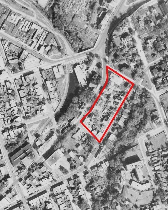
Figure 2: Cropped section of an
aerial photograph of the area,
1944, with an outline of the
subject property included. Source:
National Air Photo Library, A-
7194, 1944.By the 1940s,
LeBreton Flats was mixed-use,
low-income neighbourhood with
low rents and affordable housing
that were attractive to new
immigrants to Ottawa in the post-
war period. Taverns, light
manufacturing, craft production
and foundries were interspersed
with single family dwellings,
doubles, duplexes, triples,
apartments, commercial
buildings, institutional structures,
retail, and warehousing. Level
railway crossings, streetcars along
Wellington and Albert streets, and
noisy industries were part of the
mix.
As summarized in a Phase 1 archaeology report by Past Recovery Services:
By the 1950s and 1960s, the Flats came to be seen as a slum by city
planners. In April of 1962, residents north of Primrose Avenue were sent
letters notifying them that the National Capital Commission (formed in
1959) had expropriated their property. Although redevelopment of the
Flats had been considered in previous federal planning exercises (e.g. Todd
Holt, etc.), the impetus for the expropriation came from a plan prepared by
famous French architect and town planner Jacques Gréber (the plan, titled
General Report on the Plan for the National Capital (1946–1950) is
commonly referred to as the ‘Gréber Plan’). The Gréber Plan advocated for
a coordinated program of improvements to the capital, including removing
the railways from central Ottawa. By the end of the 1960s, the Flats had
been completely razed, representing one of Ottawa’s largest urban renewal
projects. Extensive deposits of fill were laid down over portions of the Flats,
17 June 2020
CHIS – OPL-LAC Joint Facility #: 20-CW-555
Page 5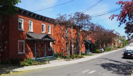
burying the basements, foundation walls, and concrete floors of the many
       demolished structures, as well as the surrounding yards. This demolition
       left an open plain, with only the streets surviving. The only remaining
       building in the LeBreton Flats area was the Water Works Corporation
       pumping station.
The properties that are now part of the lot at 555 Albert Street were part of an area that was
divided into lots in the 1840s. There was very little development, however, until after the fire
of 1900. In the early 20th century, the blocks were filled in with a mix of multiple-unit blocks
and commercial units facing Albert Street and larger homes and semi-detached houses facing
Wellington Street.

                                                   Figure 3: Typical scale and type of residential
                                                   development along Albert Street east of Booth Street,
                                                   1962, prior to the clearing of LeBreton Flats. Source:
                                                   COA CA-21066, taken from Past Recovery, Stage 1
                                                   Archaeological Assessment of LeBreton South, p 133.

1.3.4 Capital Context
The property at 555 Albert Street will have its primary access via Albert Street, but it will be
visually prominent along the escarpment that is shared with Parliament Hill. It’s function as
the new public face of the LAC (which currently occupies a commanding site immediately
west of the Supreme Court of Canada on Wellington Street), its direct connections to Capital
pathways, visibility from Confederation Boulevard and views from the building to the
Chaudière Islands and across the Ottawa River will strengthen the position of LeBreton Flats
as being a key part of the Capital.

                                                                               Figure 4: Parliamentary
                                                                               Precinct Context. Source:
                                                                               NCC, May 2019.

                                                                                         17 June 2020
                                                           CHIS – OPL-LAC Joint Facility #: 20-CW-555
                                                                                                Page 6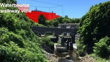
Figure 5: Capital
                                                                             Context. Source: NCC,
                                                                             May 2019.

1.3.5 Planning Summary
Information about the planning context of the proposed project is contained in the Planning
Rationale + Design Brief in support of the Official Plan Amendment and Zoning By-law
Amendment of 557 Wellington Street, 584/587 Wellington Street and 550 Albert Street (2018).
The subject property is addressed as 557 Wellington Street in the brief. A proposed library
development is described in the brief in a configuration that closely matches the design under
consideration in this CHIS. The brief imagines the building as being a four-storey institutional
building “strategically placed abutting NCC open space, and active transportation corridors,
making the site easily accessible by all modes of transportation” (P. 27).
The proposed Official Plan Amendment was required to amend the Central Area Secondary
Plan to designate the entire site (557 Wellington, 584/587 Wellington and 550 Albert) as
“Mixed-Use” in order to permit a range of uses including but not limited to: residential, retail,
office and institutional. The Amendment would further permit a maximum height of twenty-
five (25) storeys on the 584/587 Wellington portion of the site and a height limit of 40 metres
on the 557 Wellington site where the new Central Library is to be located.
The proposed Zoning By-law Amendment would amend the zoning of the subject property to
“Mixed-Use Downtown Zone (MD)”. This would permit a maximum building height of 40
metres at 557 Wellington (now 555 Albert Street.)
The planning brief does not discuss reference heritage designations of either of the two
Heritage Conservation Districts or individually designated properties, other than the Ottawa
Water Works complex. It does note, however, that the Central Area Secondary Plan calls for
the protection of its distinct identity and heritage character and the primacy of the Parliament
Buildings and other national symbols, and that Albert Street (which is a major western access
route to Parliament Hill) is identified as a Scenic Entry Route (P. 16).

1.3.6 General Description of the Property
The subject property is a vacant site in use for staging infrastructure projects. It is located at
555 Albert Street, west of Bronson Avenue and east of Pimisi Station on the Confederation
LRT line. The property is approximately 900 m2 in size. It slopes in a northwesterly direction
on a terrace overlooking LeBreton Flats, the Ottawa Water Works Building, and the tailrace
and aqueduct. Residential and commercial structure formerly located on the site were
demolished in the 1960s as part of the clearing of LeBreton Flats. The site faces Albert Street.

                                                                                         17 June 2020
                                                           CHIS – OPL-LAC Joint Facility #: 20-CW-555
                                                                                                Page 7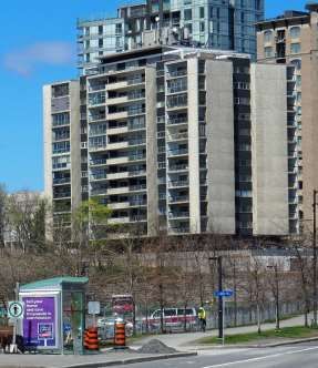
The lots across the street are currently landscaped, but they may be developed or changed
with the renewal of Albert Street. As explained above, however, this CHIS is not examining the
cumulative impacts that might result from both projects (the library development and
renewal of Albert Street.)

1.3.7 Public Involvement
The development of the design of the proposed OPL-LAC Joint Facility involved extensive
public input through the Inspire555 program, including 211 participants attending three in-
person workshops in four separate locations and 589 responses to online engagement
activities. Due to COVID-19 conditions, a public Urban Indigenous Engagement session was
replaced by a more direct engagement program that was still in process during the writing of
the CHIS.
Through public input, the design for the building, circulation system, and grounds went
through a series of changes related to the division of functions, interfaces with
neighbourhoods and programming. The first concept showed the building as having distinct
layers for the OPL, the LAC and shared public functions. The second concept presented itself
as a series of three peaks, that generally aligned with the three functions. The final concept
interlocked the three functions together, while simultaneously allowing individual
requirements, such as levels of security and access, to be integrated into the design of the
respective spaces of the OPL and LAC.

1.3.8   Heritage Value
As confirmed with City of Ottawa heritage staff, the subject property has not been identified as
having heritage value, but it is located in close proximity to a number of formally listed
heritage resources, as well as on a key scenic route that leads to Parliament Hill. It is also
located on land that was part of LeBreton Flats, which is the location of the Ottawa Water
Works and is connected to Ottawa’s early history.

                                                                                       17 June 2020
                                                         CHIS – OPL-LAC Joint Facility #: 20-CW-555
                                                                                              Page 8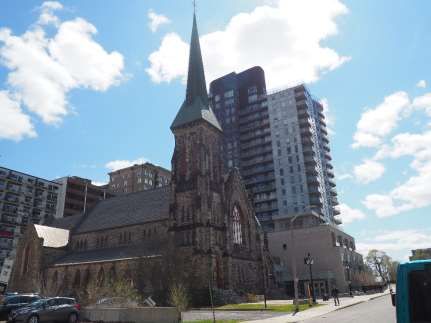
2 Heritage Resource Descriptions and Histories
2.1 Formal Municipal Recognitions
This section provides information on formally recognized heritage properties that are located
close to the subject site. Other heritage properties are likely to experience a direct impact
from the development, but potential impacts and mitigation measures described in this CHIS
could also be applied to the other properties if required.

.

                                                                      Figure 6: The properties
                                                                      identified by the City of
                                                                      Ottawa that are to be
                                                                      considered for this CHIS are
                                                                      shown on this map, which
                                                                      also includes the
                                                                      rectangular outline of the
                                                                      subject property. The red
                                                                      dots indicate properties
                                                                      included on the City of
                                                                      Ottawa Heritage Register
                                                                      that are discussed in this
                                                                      CHIS. The named or
                                                                      addressed properties are
                                                                      designated through the
                                                                      Ontario Heritage Act as
                                                                      either individual properties
                                                                      or heritage conservation
                                                                      districts

2.1.1 Designated Individual Properties

2.1.1.1 Ottawa Water Works Complex – Values and Attributes
The Ottawa Water Works complex is a cultural heritage landscape comprised of the City
Water Works Building at 10 Fleet Street, the old open aqueduct to the west including the
headworks, the channelled tailrace to the north of the pumping station, and five stone bridges
that cross the aqueduct. The bridges include four single-span bridges; the Canada Central
Railway, Broad Street, Booth Street, and the combined Lloyd/Lett/Grand Trunk Railway
bridge and the triple span Pooley’s Bridge, located north of the pumping station. The complex
was constructed in 1872-74, with additions to the Water Works building in 1888 and 1899.

                                                                                      17 June 2020
                                                        CHIS – OPL-LAC Joint Facility #: 20-CW-555
                                                                                             Page 9
The Ottawa Water Works is located on LeBreton Flats, west of downtown Ottawa.
By-law Number 22-82 designated the “City Waterworks Building on Fleet Street” under the
provisions of the Ontario Heritage Act. The City of Ottawa’s Statement of Cultural Heritage
Value for the designation and an updated draft statement that references the broader set of
structures and the aqueduct are included as Appendix 1. The historic Ottawa Water Works
was also recognized as an American Water Works Association Canadian Waterworks
Landmark in 1981.3
The City of Ottawa’s first pumping station to distribute potable and fire-fighting water was
built in the south-eastern quadrant of the Flats to plans prepared by engineer Thomas Keefer
in 1873-74. The flow of water that drove the pumps was regulated by headworks at the intake
on Nepean Bay; it was brought to the pumping station through an aqueduct built through the
southern portion of the Flats between 1872 and 1875, following a former stream channel of
the Ottawa River. A separate pipe installed in the aqueduct drew in water that was sanitized
to the standards of the day. Eventually, the covered aqueduct was constructed to the north of
the open aqueduct along what was Ottawa Street.
The heritage attributes associated with the Ottawa Water Works complex of historic
resources includes elements connected to the Water Works Building, the aqueduct, bridges
and views. The attributes are focused almost exclusively on the physical design, construction
and appearance of the structures. The view that is most pertinent to this CHIS is the view
north and south from Pooley’s Bridge of the tailrace and the Water Works Building. The
covered aqueduct is part of the cultural landscape of LeBreton Flats but it has not received a
formal review from the City of Ottawa to date.
Figure 7: Ottawa Water
Works Building. The proposed
development will sit on the
bluff behind the building.
Source: Contentworks, 2020.
3American Water Works Association, “Water Landmarks Award,” online at: www.awwa.org/Membership-
Volunteering/Awards/Water-Landmarks-Award.
17 June 2020
CHIS – OPL-LAC Joint Facility #: 20-CW-555
Page 10Figure 8: Ottawa Water
Works, with a corner of the
building on the left, and the
aqueduct in the foreground.
The proposed development
will sit on the bluff behind the
building. Source:
Contentworks, 2020.
Figure 9: Proposed OPL-LAC
Joint Facility concept from the
perspective of the photograph
above. Source:
https://inspire555.ca/library-
archives-design/.
2.1.2 494 Albert Street and 504 Albert Street
Two properties at 494 and 504 Albert Street were expropriated in the 1980s by the Regional
Municipality of Ottawa-Carleton as part of a larger plan to retain the land under or near –
Built circa 1864 and designed in the Second Empire style, 494 Albert Street is an excellent
small-scale example of the style and a surviving example of homes that were part of the large
residential neighbourhood that extended west and south of Ottawa’s commercial core. It is
owned by the City.
Figure 10: 494 Albert Street, main elevation. Source:
Google streetview, May 2019.
The building at 504 Albert Street was remodelled and expanded around 1889 from a one-and-
a-half-storey, stone structure (as seen in its stone walls) originally built c 1864. The eclectic
17 June 2020
CHIS – OPL-LAC Joint Facility #: 20-CW-555
Page 11building with Queen Anne and Tudor Revival detailing was well suited to its owner, Morley
Donaldson, who was superintendent of the Canada Atlantic Railway. The building sits on
Albert Street, directly to the east of the OPL-LAC site.
Figure 11: 504 Albert Street, west side elevation
facing towards the OPL-LAC Joint Facility site.
Source: Contentworks, May 2020.
2.1.3 Heritage Conservation Districts
2.1.3.1 Lorne Avenue Heritage Conservation District – Values and Attributes
The Lorne Avenue HCD (By-law 2005-13) was designated under Part V of the Ontario
Heritage Act in 2005. Lower Lorne Avenue (between Albert Street and Primrose Avenue) is a
homogeneous, well-preserved street, typical of the type of housing built in Ottawa for the
working class from 1900 – 1907 but is also an important remnant of construction on LeBreton
Flats following the Great Fire of 1900. Lorne Avenue’s cultural heritage significance is
enhanced by the fact that its character is representative of the type of residential streetscape
that was eliminated when the LeBreton Flats community was levelled in the early 1960s.
The continuing conservation of the Lorne Avenue HCD requires all development along Albert
Street to be mindful of additional pressures on the district’s built heritage and landscape from
traffic and parking. This issue will be considered in the review of applications for the
development of the parcel on the north side of Albert Street east of Booth Street, directly
across from Lorne Avenue.
Figure 12: Lorne Avenue
(west side), in the Lorne
Avenue HCD. Source:
Contentworks, 2020.
17 June 2020
CHIS – OPL-LAC Joint Facility #: 20-CW-555
Page 12Figure 13: Map showing
the boundaries of the
Lorne Avenue HCD.
Source: City of Ottawa.
2.1.3.2 Cathedral Hill Heritage Conservation District – Values and Attributes
The Cathedral Hill HCD (By-law 286-89) is located east of LeBreton Flats. The district was
designated by the City of Ottawa in 1989. The west and north boundaries extend along
Wellington Street from Albert Street along the ridge that serves as the north-western edge of
Centretown. In 2011, a partnership between a developer and the Anglican Church resulted in
the extensive redevelopment of the vacant lands and some heritage buildings within the HCD
for an office tower, a residential condominium tower and townhouses flanking the Cathedral.
The HCD has cultural heritage value as a grouping of architecturally significant buildings
centred on Christ Church Anglican Cathedral. The buildings of the HCD are an important
landmark in Ottawa that is visible from the nearby Garden of the Provinces, LeBreton Flats
and Confederation Boulevard. Properties on the Heritage Register.
17 June 2020
CHIS – OPL-LAC Joint Facility #: 20-CW-555
Page 13Figure 14: Christ Church
Cathedral, looking west
on Sparks Street
towards the new
development in the HCD.
The Juliana Apartments
building is obscured by
the tall condominium
development in the HCD.
Source: Contentworks,
May 2020.
Figure 15: Map showing
the boundaries of the
Cathedral Hill HCD.
Source: City of Ottawa.
17 June 2020
CHIS – OPL-LAC Joint Facility #: 20-CW-555
Page 142.1.4 Properties on the Heritage Reference List
2.1.4.1 Juliana Apartment Building, 100 Bronson Avenue
The 13-storey Juliana Apartment Building
was completed in 1962 to the design of
Peter Dickinson and Associates, Alistair
Ross and Peter Douglass. It is a modernist
building clad in pebble-finish concrete
panels with grey slate details, and glass
panels on balconies. It is perched on the
escarpment looking over LeBreton Flats.
The southwest corner of the building will
be about 55 m from the east wall of the
OPL-LAC building.
Figure 16: Juliana Apartments, 100 Bronson. Source:
Contentworks, May 2020.
2.1.4.2 Hillview, 481 Slater Street
The house at 481 Slater Street was
constructed c 1901. It is a brick house, two-
and-a-half storeys in height with brick
cladding and Tudor Revival detailing. It is a
vernacular example of eclectic Edwardian-
era styling, combining elements from the
Queen Anne and Gothic Revival idioms. The
house is divided into apartments. The
property is part of a parcel of land available
for sale as a redevelopment opportunity
that includes 99 Bronson Avenue, 481
Slater Street, 479 Slater Street, 475-477
Slater Street, 467 Slater Street and 488
Albert Street.4
Figure 17: Hillview, 481 Slater Street. Source:
https://sleepwellmanagement.com/wp-
content/uploads/2020/04/481-Slater.jpg, accessed
25 May 2020.
4 See prospective sheet at: https://www.collierscanada.com/en-ca/properties/slater-station-28328-square-foot-
land-assembly-in-ottawas-downtown-core/CAN-481-slater-street-ottawa-ontario-canada/can2003372. Accessed
25 May 2020.
17 June 2020
CHIS – OPL-LAC Joint Facility #: 20-CW-555
Page 152.1.4.3 479 Slater Street
The house at 479 Slater Street was
constructed c 1900. It is a brick house, two-
and-a-half storeys in height with brick
cladding. It is a vernacular example of
eclectic late-Victorian-era domestic
architecture.
Figure 18: 479 Slater Street. Source: City of Ottawa
Heritage Register Map
2.1.4.4 475-7 Slater Street
The semi-detached residential building at
475-7 Slater Street is a handsome example
of eclectic Edwardian-era architecture built
c 1900. It is a brick clad with a combination
of Queen Anne and Italianate elements.
Figure 19: 475-7 Slater Street. Source: City of Ottawa
Heritage Register Map.
2.1.4.5 684-686 Albert Street
The building at 684-686 Albert Street is a
two-and-a-half storey brick semi-detached
residence clad in brick that may have been
built to contain two units on each of the
main floors. It is a vernacular design that is
typical of Edwardian Classicism.
Figure 20: 684-686 Albert Street. Source: Google
streetview, image May 2019.
2.1.4.6 4-6 Empress Avenue
17 June 2020
CHIS – OPL-LAC Joint Facility #: 20-CW-555
Page 16The building at 4-6 Empress Avenue, just
south of Albert Street, is a two-and-a-half
storey brick semi-detached residence clad
in brick that may have been built to
contain two units on each of the main
floors. It is a vernacular design that is
typical of Edwardian Classicism.
Figure 21: 4-6 Empress Avenue. Source: City of
Ottawa Heritage Inventory Project Property
Information Sheet, n.d.
2.1.4.7 694-696 Albert Street
The semi-detached residences at 694-696
Albert Street are very typical of residential
construction on LeBreton Flats following
the fire of 1900. This Italianate two-storey
building erected c 1910 is brick structure
with a wooden cornice and segmental arch
windows. The covered front two-storey
porch has been replaced with an open
porch.
Figure 22: 694-696 Albert Street. Source: Source:
City of Ottawa Heritage Inventory Project Property
Information Sheet, n.d.
2.1.4.8 698-700 Albert Street
The semi-detached residences at 698-700
Albert Street are very typical of residential
construction on LeBreton Flats following
the fire of 1900. This Italianate two-storey
building erected c 1902 is brick structure
with a wooden cornice and segmental arch
windows. The covered front two-storey
porch in a Classical style appears to be
original.
Figure 23: 698-700 Albert Street. Source:
Contentworks, May 2020.
17 June 2020
CHIS – OPL-LAC Joint Facility #: 20-CW-555
Page 172.2 Other Heritage
2.2.1 LeBreton Flats
LeBreton Flats has a long history (at least 8,000 years) of use by Indigenous Peoples and a
much shorter history as a site of industrial, transportation and residential development. The
Algonquin presence was clear to newcomers, as testimony in both written and oral records
demonstrates. While the area’s development from the early 19th century onwards erased the
original forested landscape, a sense of a place connected to its ancient history remains strong
due to its location near Chaudière Falls and the escarpment that rises above the Flats.
LeBreton Flats’ period of intense development as a civic space for industrial, transportation,
commercial and residential uses began in the mid 1800s and ended abruptly in the early
1960s with the clearing of the Flats by the federal government for redevelopment. Remnants
of the urban landscape that predate the clearing of the Flats are found south of Albert Street
along residential streets, but these pockets of old homes are only a fragment of the
remarkably diverse neighbourhood that spread out from what is now Bayswater Street to
Bronson Avenue and south to the escarpment.
LeBreton Flats is a cultural landscape of local, regional, provincial and national heritage
significance. It formed part of the ancestral territory of the local Algonquin Anishnabeg
communities. It was an integral part of the first generation of Euro-Canadian settlement to the
area in the early 19th century, and was central to the social, economic and industrial
development of Canada’s Capital Region for a hundred and fifty years. Its pioneering role in
the timber trade and electric power generation shaped the region’s industrial development.
Until the clearing of LeBreton Flats by the National Capital Commission in the 1960s,
LeBreton Flats was a distinct community. Its industrial, transportation and commercial plants
were situated near homes of workers and their families who kept machinery running and
operated businesses important to the entire region. A remnant of the housing remains within
the Lower Lorne Avenue Heritage Conservation District.
The clearing of the Flats envisaged in the Plan for Canada’s Capital (1950) represented one of
the largest examples in Canada of state-led urban renewal aimed at reshaping urban
landscapes around modernist ideals. For decades, however, only a small part of the renewal
plan was implemented, namely, the Ottawa River Parkway (now the Sir John A. Macdonald
Parkway).
The archaeological work that has taken place since the 1990s has made the LeBreton Flats
one of the most intensively studied archaeological resources in Ontario. The archaeological
investigations and resulting artifacts offer rich insight into the diverse vocations of the Flats
over time. It has been proven to be a rare and valuable record of a highly influential part of
19th and early 20th Century Ottawa.
17 June 2020
CHIS – OPL-LAC Joint Facility #: 20-CW-555
Page 183 Proposed Development
3.1 Designers
The building was designed by Diamond Schmitt Architects with KWC Architects Inc. and with
landscape design by PFS Studio. The design team engaged with the public in multiple open
houses and online to understand public needs and preferences, and to get input and ideas for
the design as it progressed. Over 4,000 participants contributed to the engagement process.
3.2 Overview of the Building Program
The planning principles outlined for the development are:
• Planning and framework compliance
• Design excellence
• Heritage conservation
• User/visitor experience and universal accessibility
• Environmental sustainability
• Public art and interpretation
• Consultation
To address these principles, the designers and its clients (OPL and the LAC) engaged with the
general public and key stakeholders and advisory organizations, including the City of Ottawa,
the NCC, Ottawa’s Urban Design Review Committee and the Joint Design Review Panel.
The OPL-LAC Joint Facility is aiming for LEED Gold Certification. It will be approximately
20,000 m2 in size with 61% of the space allocated to the main branch Ottawa Public Library
and 39% of the space assigned to the Library and Archives Canada.5 The two institutions are
controlled by separate levels of government and operate with distinctive obligations
concerning hours of operation, security, privacy, archival conservation requirements, etc.
While the structure presents itself as a unified whole, it manages to retain the functional
independence of each institution while allowing them to share a large portion of public
spaces, building services and amenities indoors and outside. Spaces dedicated exclusively to
each one of the two institutions will include reading and reference rooms, controlled areas,
administrative offices, etc.
The facility will contain 21 functional components made up of OPL-only spaces, LAC-only
spaces, and shared spaces. The shared spaces will enhance the complementary but unique
nature of OPL and LAC services, and will include:
• Exterior Spaces – a shared outdoor space for programs and activities, acting as an
interface between the building and the public realm
• A Main Entrance and Town Square – a shared entrance space with access to OPL and
LAC spaces, and meeting spaces, featuring a café and Gift Shop
• Public Forum and Meeting Spaces – large multipurpose spaces for programming and
events for the community, as well as both OPL and LAC
5National Capital Commission, Ottawa Public Library (OPL)/Library and Archives Canada (LAC) – Joint Facility
Schematic Design and Public Engagement, ACPDR, May 16-17, 2020. Presentation.
17 June 2020
CHIS – OPL-LAC Joint Facility #: 20-CW-555
Page 19• An Exhibition Gallery – museum-quality spaces featuring exhibitions of rare and
unique LAC collections, travelling exhibitions; and OPL and City of Ottawa community
exhibitions
• A Genealogy Centre – a one-of-a-kind research space offering OPL and LAC services
and collections.
The OPL-LAC Joint Facility building is oriented with the long side running roughly on the
east/west axis with the main entrance located on the southeast corner facing Albert Street.
Additional entrances are found on each side, including a second entrance on the south side
and a corner entrance leading to primary outdoor spaces on the northwest corner.
Level 1 is near grade; two levels for parking and services are located below. The building rises
5 levels (24 m in total) above grade. A four-storey atrium above the “Town Hall” will be
surmounted by a roof that will draw in light from horizontal roof windows slotted into folds of
the roof. The roof structure of concrete piers, steel struts and wood-framed panels will be
visible inside and through the windows from the outside.
Figure 24: Concept drawing of
the main (north) elevation on
the east end showing the
entry plaza area for the OPL-
LAC Joint Facility, 555 Albert
Street. Source:
https://inspire555.ca/library-
archives-design/.
Figure 25: Concept drawing of
the main (north) and west
elevations at the end of the
entry drive for the OPL-LAC
Joint Facility, 555 Albert
Street. Source:
https://inspire555.ca/library-
archives-design/.
17 June 2020
CHIS – OPL-LAC Joint Facility #: 20-CW-555
Page 20Figure 26: Concept drawing of
the main (north) elevation of
the OPL-LAC Joint Facility in
winter, 555 Albert Street.
Source:
https://inspire555.ca/library-
archives-design/.
Figure 27: Concept drawing of
the atrium of the OPL-LAC
Joint Facility. Source:
https://inspire555.ca/library-
archives-design/.
Figure 28: Concept for the
two-storey reading room on
the top level of the OPL-LAC
Joint Facility. Source:
https://inspire555.ca/library-
archives-design/.
The footprint of the building covers about 60% of the site. The grounds of the site are planned
to include spaces designed as a reading garden, amphitheatre, gathering circle, library plaza
and terrace. The grounds will be connected to the region’s multi-use path system that will also
provide a pleasant path to Pimisi Station.
17 June 2020
CHIS – OPL-LAC Joint Facility #: 20-CW-555
Page 213.3 Architectural Design and Style
The OPL-LAC Joint Facility is a contemporary structure designed in an expressive modern
style that links visually and symbolically to the surrounding landscape and its history. While
the main public entrance to the Joint Facility will be on the south side facing Albert Street, the
most important elevations of the building are facing west and north overlooking the Ottawa
River and LeBreton Flats. From within the building, the reading rooms on these sides will
open to dramatic views of the Ottawa River and be bathed in north light that is prized for
document reviews and casual reading.6
The expressive style of the building is seen in its forms and materials. Most of the exterior
walls will be clad in Wiarton limestone, with the exact finishes yet to be determined. The goal
is to ensure a sufficient complexity of texture across the stone faces. The stone facing,
combined with the angled and curved shape of the walls will be reminder of sedimentary rock
layers of the escarpment that links the site to Parliament Hill. Clear-coated wood is used as a
noble material on street-level entrances and soffits, and for the massive timber roof that will
be visible through the windows of the top storey. The structure’s generous use of curvilinear
and organic forms for the walls and roof speak not only to the Ottawa River and the contours
of the area’s topography, but also, in a related way, to Indigenous ways of knowing and living.
As per the iconic Canadian Museum of History designed by Douglas Cardinal, the curves
reinforce the idea of continuity and the sense of connection between people, nature and the
spiritual world. The shape also echoes the Ottawa River, not only as the heart of the Capital
region, but also as a symbol of the waterways that bind Canada together.
Wood, stone, concrete and glass are positioned as complementary materials. Outside, soft
surfaces are highlight through designs that include hard elements that frame views and allow
closer access without damaging fragile plantings.
Figure 29: Roof plan
illustrating the green
roof areas in solid grey.
Source: Diamond
Schmitt Architects/KWC,
JDRP Presentation,
February 2020.
Carpets of grasses will cover most of the undulation slopes of the building’s roof on all sides,
with the centre part of the roof opening to a set of sawtooth clerestory windows that will
draw north light into the atrium. In addition to helping meet sustainability goals, the green
roof will become a key visual element when looking down towards LeBreton Flats, including
views to the west along Albert Street.
6The current Library and Archives Canada building features large reading rooms that overlook the Ottawa River.
For researchers, the quality of the light, the floor-to-ceiling windows, and the large scale of these rooms heightened
awareness of the importance of Library and Archives Canada as an institution with a mission of national value.
17 June 2020
CHIS – OPL-LAC Joint Facility #: 20-CW-555
Page 22Figure 30: Modeled view of the
OPL-LAC Joint Facility looking
west on Albert Street. The current
design would show the green roof
as covering about a portion of this
view in the light pink area.
Source: NCC, May 2019.
3.4 Outdoor Spaces and Landscape
The OPL-LAC Joint Facility has been planned with a series of outdoor spaces, including a
reading garden, gathering circle, library plaza and amphitheatre. Hard surfaces that extend on
all sides of the building will provide barrier-free access to its multiple entrances. The
amphitheatre area is proposed as a multi-purpose space with the potential of including a
water feature in the centre that would operate when the amphitheatre is not in use for other
purposes. Long benches are proposed for seating around the reading and gathering areas.
Most of the green spaces will be concentrated on the west side of the building where visitors
will arrive from Pimisi Station or the bus on Albert Street.
While designed exclusively as a green roof to sustainable design principles, rather than a
green roof-top terrace as outdoor space, the greened slopes of the roof are part of the
landscape treatment by softening views of the building from all sides.
Figure 31: Landscape
plan, February 2020.
Source: Diamond
Schmitt Architects, PPS
Studio, JDRP
Presentation.
3.5 Circulation (Exterior)
The circulation system is designed to handle about 5,000 or more visitors per day, as well as
staff and suppliers. Visitors and staff arriving from Pimisi Station would normally enter on the
lower level on the northwest end of the building, but there will also be two public entrances
on Albert Street. Based on the current concept for the realignment of Albert Street, the
building will be set back 10 m from the street, with allowance for a sidewalk, cycle track, a
row of trees, and parking curb signed for drop-offs, ParaTranspo, emergency vehicles, etc.
Visitors and staff using underground parking will enter on the northeast end of the building
on Commissioner Street. The bus platform, which includes a shelter. will be long enough for
17 June 2020
CHIS – OPL-LAC Joint Facility #: 20-CW-555
Page 23two articulated buses. The building includes 200 parking spaces below grade and 120 bicycle
spaces.
Figure 32: General site
plan showing circulation
systems outside the
building in relation to
the main floor and hall.
Source: NCC, May 2019.
3.6 Streetscapes and Views
The building will become, in effect, a terminus view looking west from downtown on Albert
Street and a key view from Albert and Slater streets going east towards downtown. It will also
be visible from Pimisi Station, especially on the north side along the multi-use path due to the
position of the building at an angle from the planned siting of development at the corner of
Albert and Booth streets to the west of 555 Albert Street.
The proposed building will be highly visible from the Ottawa Water Works, the tailrace and
other points along the Old Aqueduct. At the same time, the new building will raise the
visibility of these heritage resources and others by opening views to the 5000+ daily visitors.
Figure 33: Current view looking
west on Albert Street towards
Bronson Avenue and the subject
site. Source: Contentworks, 2020.
17 June 2020
CHIS – OPL-LAC Joint Facility #: 20-CW-555
Page 24Figure 34: Modeled view looking
east along the LRT line with a
block sketch of the proposed
building inserted. Source: NCC,
May 2019.
Figure 35: Modeled view looking
south from the Ottawa Water
Works tailrace with a block sketch
of the proposed building inserted.
Source: NCC, May 2019.
Figure 36: View to the west at the
height of the upper floors of the
proposed building. Source: NCC,
May 2019.
Figure 37: View to the eeast at the
height of the upper floors of the
proposed building. Source: NCC,
May 2019.
17 June 2020
CHIS – OPL-LAC Joint Facility #: 20-CW-555
Page 253.6.1 OPL-LAC Joint Facility Public Art and Interpretation
Jason Bruges Studio was awarded the “Artist on Design Team” commission for the Ottawa
Public Library-Library and Archives Canada Joint Facility (OPL-LAC Joint Facility). Seventy-
four national and international artists submitted their work for consideration during a two-
stage competitive process. The project will also include an Indigenous Art and Placemaking
Program led by an Indigenous Curator to recognize, support and value Indigenous art and
cultures. Consultation with Anishnabe Algonquin People are in process to more fully
development public art and interpretation plans.
17 June 2020
CHIS – OPL-LAC Joint Facility #: 20-CW-555
Page 264 Impact of Proposed Development
4.1 Description of Potential Impacts
This section outlines the impacts that might be expected from the OPL-LAC Joint Facility
project. Impacts are considered by examining specific criteria identified in the City of Ottawa’s
guide to writing a CHIS, as well as standards and guidance from the Standards and Guidelines
for the Conservation of Historic Places in Canada and the Provincial Policy Statement.
Extracted for the City of Ottawa’s CHIS guidelines, characteristic positive impacts that might
be pertinent to the development are:
• Restoration of an historic streetscape or enhancement of the quality of the place
Due to the nature of the development and its emphasis on sharing stories about LeBreton
Flats and the area’s history and Indigenous connections, the City asked that a related potential
positive characteristic to be considered:
• Contributing to an understanding of heritage resources and values in the area.
Extracted for the City of Ottawa’s CHIS guidelines, characteristic negative impacts that might
be pertinent to the development are:
• Alteration that is not sympathetic, or is incompatible, with the historic fabric and
appearance of a building
• Shadows created that obscure heritage attributes or change the viability of the
associated cultural heritage landscape
• Obstruction of significant identified views or vistas related to the heritage value of
resources
• Isolation of a heritage resource or part thereof from its surrounding environment,
context or a significant relationship
• Land disturbances such as a change in grade that alters soils, and drainage patterns
that adversely affect a cultural heritage resource
The most relevant standards from the Standards and Guidelines for examining the potential
impacts are [to be confirmed]:
Standard 1: Conserve the heritage value of an historic place.
In considering the policy directions of the Provincial Policy Statement, 2020, objectives are
directly related to heritage are:
1.7.1 e) encouraging a sense of place, by promoting well-designed built form and
cultural planning, and by conserving features that help define character, including
built heritage resources and cultural heritage landscapes
2.6.1 Significant built heritage resources and significant cultural heritage landscapes
shall be conserved.
2.6.3 Planning authorities shall not permit development and site alteration on
adjacent lands to protected heritage property except where the proposed
development and site alteration has been evaluated and it has been demonstrated that
the heritage attributes of the protected heritage property will be conserved.
2.6.5 Planning authorities shall engage with Indigenous communities and consider
their interests when identifying, protecting and managing cultural heritage and
17 June 2020
CHIS – OPL-LAC Joint Facility #: 20-CW-555
Page 27archaeological resources.
These objectives need to be balanced against other policy objectives relevant to the OPL-LAC
Joint Facility project, such as:
1.6.1 “Planning for infrastructure and public service facilities shall be coordinated and
integrated with land use planning and growth management so that they are: a)
financially viable over their life cycle, which may be demonstrated through asset
management planning; and b) available to meet current and projected needs.
1.7.1 f) promoting the redevelopment of brownfield sites
2.6.1 Significant built heritage resources and significant cultural heritage
landscapes shall be conserved.
2.6.3 Planning authorities shall not permit development and site alteration on
adjacent lands to protected heritage property except where the proposed
development and site alteration has been evaluated and it has been demonstrated
that the heritage attributes of the protected heritage property will be conserved.
2.6.5 Planning authorities shall engage with Indigenous communities and consider
their interests when identifying, protecting and managing cultural heritage and
archaeological resources.
4.1.1 Impacts from Other Projects in the Area
The OPL-LAC Joint Facility is only one of several projects that are either actively underway or
planned for the area that have potential to impact all or most of the heritage resources
discussed in this CHIS. The fluidity of development programs and the likelihood that there will
be a cumulative impact that is more than the sum of each of the programs makes it difficult to
assess the subject project independently. This reality should be considered when considering
impacts and mitigation measures proposed in this CHIS for the single project. Some of the
projects are:
Further development of East LeBreton Flats, with potential impact on the Old Aqueduct
• The general development of LeBreton Flats, with potential impact on all resources
noted in this CHIS, but especially the Lorne Avenue HCD and buildings on Albert Street
and Bronson Avenue
• Proposed development of 584 Wellington Street, immediately west of 555 Albert
Street, with potential impact on the Lorne Avenue HCD and buildings on Albert Street
west of Bronson
• Reconfiguration and redesign of Albert and Slater streets, with potential impact on all
resources noted in this CHIS, but especially the Lorne Avenue HCD and buildings on
Albert Street and Bronson Avenue
• Proposed redevelopment of 99 Bronson Avenue, 481 Slater Street, 479 Slater Street,
475-477 Slater Street, 467 Slater Street and 488 Albert Street, affecting 494 Albert
Street and 504 Albert Street
17 June 2020
CHIS – OPL-LAC Joint Facility #: 20-CW-555
Page 284.2 Summary of Positive Heritage Impacts (CHIS Guidelines)
Type Comments Impacted Properties
Enhancement of the quality of the place
The proposed development will create a landmark of shared • Ottawa Water Works
importance to the city and the Capital and help strengthen the (medium)
connection between LeBreton Flats and Ottawa’s core. • Lorne Avenue HCD
(low)
The quality of the design of the development will help beautify
• All individual heritage
and clarify the role of Albert Street as a Scenic Route in the
properties on Albert
Capital from both directions, but especially from downtown
Street west of
going west where the building will be very visible, appearing
Empress Avenue
almost as a terminal point for the street.
(low)
The quality of the streetscape in relation to appreciating the • 504 Albert Street
heritage buildings in the area and retaining their viability in (low)
remaining in place will depend to a greater extent on the • 494 Albert Street
treatment of the Albert Street and Slater Street reconfiguration (low)
and any development that occurs closer to these buildings. • Cathedral Hill HCD
The use of limestone cladding on the new building will help (low)
reinforce an appreciation of the importance of limestone in the
development of Ottawa as the Capital, as also seen in the
Ottawa Water Works.
Contributing to an understanding of heritage resources and values in the area and
neighbourhoods
The proposed OPL-LAC Joint Facility will be a key cultural • Ottawa Water Works
destination and service in Ottawa and the Capital. The project (medium)
will deliberately convey heritage ideas and information through • Lorne Avenue HCD
its materials, forms, landscape treatment, and programming of (medium)
exhibit areas and meeting spaces. Public artwork, such as • Cathedral Hill HCD
fountains and sculptures, will also contribute to the valuation of (low)
the area’s history and heritage. • All other heritage
properties, as well as
One of the key goals of the project is to enhance access to and
Ottawa’s Indigenous
visibility for national collections and resources.
heritage and realities,
The use of a Curator for Indigenous collections and LeBreton Flats, the
placemaking is an important indicator that the intentions of the Ottawa River, Ottawa
public art, interpretation and sense of place will be realized. and the Capital
Further mitigation measures could be considered. (medium-high)
17 June 2020
CHIS – OPL-LAC Joint Facility #: 20-CW-555
Page 29You can also read