Liffey Cycle Route Options Assessment Report - Prepared by Roughan & O'Donovan Arena House, Arena Road, Sandyford, Dublin 18 Tel: +353 1 2940800 ...
←
→
Page content transcription
If your browser does not render page correctly, please read the page content below
Liffey Cycle Route Options
Assessment Report

               Prepared by
               Roughan & O’Donovan
               Arena House, Arena Road, Sandyford, Dublin
               18
               Tel: +353 1 2940800 Fax: +353 1 2940820
               Email: info@rod.ie www.rod.ie
Roughan & O’Donovan                                                                                                                                                                                                                                                                      National Transport Authority
Consulting Engineers                                                                                                                                                                                                                                                  Liffey Cycle Route Options Assessment Report

                                                    Liffey Cycle Route                                                                                                 6.1    Ecology ................................................................................................................................11
                                               Options Assessment Report                                                                                               6.2    Architecture ..........................................................................................................................11
                                                                                                                                                                       6.3    Archaeology .........................................................................................................................11
                                                     TABLE OF CONTENTS                                                                                                 6.4    Landscape and Visual ..........................................................................................................11
                                                                                                                                                                       6.5    Physical Infrastructure ..........................................................................................................11
EXECUTIVE SUMMARY ........................................................................................................... IV                                       6.6    Traffic ...................................................................................................................................12

1.     INTRODUCTION ................................................................................................................. 1                                6.7    People ..................................................................................................................................12
                                                                                                                                                                       6.8    Other Plans and Policies ......................................................................................................12
2.     CONTEXT............................................................................................................................ 2
                                                                                                                                                                       6.9    Other Projects ......................................................................................................................12
       2.1      Need for the Scheme ............................................................................................................. 2
       2.2      Existing Facilities ................................................................................................................... 2         7.   OPTIONS ASSESSMENT STAGE 1 – FEASIBILITY SCREENING ................................. 13
                2.2.1 North Quays ............................................................................................................... 2                    7.1    Network Option 1: Do-Nothing Scenario ...............................................................................13
                2.2.2 South Quays............................................................................................................... 3                     7.2    Network Option 2: One-way Building Side cycle facility on North and South Quays..............13
       2.3      Demand ................................................................................................................................. 3             7.3    Network Option 3: One Way Riverside Cycle Tracks on North and South Quays .................13
                2.3.1 Cycling Flows ............................................................................................................. 3                    7.4    Network Option 4: Two-way Cycle Track on North Quays – Building Side ............................13
                2.3.2 Movement Patterns .................................................................................................... 3                         7.5    Network Option 5: Two-way Riverside Cycle Track on North Quays .....................................13
       2.4      Collision Data......................................................................................................................... 3              7.6    Network Option 6: Two-way Cycle Track on South Quays – Building Side ...........................13
3.     EARLIER STUDY ................................................................................................................ 5                                7.7    Network Option 7: Two-way Riverside Cycle Track on South Quays ....................................14

       3.1      Initial List of Options Considered............................................................................................ 5                       7.8    Network Option 8: Two-way Riverside Facilities on North and South Quays.........................14

       3.2      Options Shortlisted for Public Consultation ............................................................................ 5                             7.9    Network Option 9: Two-way Facility Parallel to North Quays ................................................14

       3.3      Shortlisted Options ................................................................................................................ 5                 7.10 Network Option 10: Two-way Facility Parallel to South Quays ..............................................14

       3.4      Concerns Regarding the Shortlisted Options ......................................................................... 5                                 7.11 Network Option 11: Off-line Routes ......................................................................................14
                                                                                                                                                                       7.12 Network Option 12: Two-Way Public Transport on South Quays ..........................................14
4.     TERMS OF REFERENCE FOR CURRENT COMMISSION ................................................ 7
                                                                                                                                                                       7.13 Network Option 13: Two-way Public Transport on North Quays ...........................................15
       4.1      The Brief ................................................................................................................................ 7
                                                                                                                                                                       7.14 Network Option 14: One-way Cycle Lanes with Contra Flow Bus Lanes on Both Quays ......15
       4.2      Proposed Study Area ............................................................................................................. 7
                                                                                                                                                                       7.15 Network Option 15: Reversal of Traffic Flow Direction on Quays ..........................................15
       4.3      Additional Developments since Earlier Study ......................................................................... 7
                                                                                                                                                                       7.16 Network Option 16: In-river Route ........................................................................................15
       4.4      Methodology for Options Assessment .................................................................................... 7
                                                                                                                                                                       7.17 Conclusion of Stage 1 Assessment ......................................................................................15
5.     DESIGN PRINCIPLES AND ASSUMPTIONS ..................................................................... 9
                                                                                                                                                                  8.   OPTIONS ASSESSMENT STAGE 2 – HIGH LEVEL IMPACT ASSESSMENT ............... 17
       5.1      Quality of Service ................................................................................................................... 9
                                                                                                                                                                       8.1    Section 1: Phoenix Park to Father Matthew Bridge ...............................................................17
       5.2      Segregation ........................................................................................................................... 9
                                                                                                                                                                              8.1.1 Sub-Section 1A – Phoenix Park to Sean Heuston Bridge ..........................................17
       5.3      Integration and Access .......................................................................................................... 9
                                                                                                                                                                              8.1.2 Sub-Section 1B - Sean Heuston Bridge to Frank Sherwin Bridge..............................18
       5.4      Transitions ............................................................................................................................. 9
                                                                                                                                                                              8.1.3 Sub-Section C – Frank Sherwin Bridge to Rory O’More Bridge .................................19
       5.5      Width ..................................................................................................................................... 9
                                                                                                                                                                              8.1.4 Sub-Section 1D - Rory O’More Bridge to James Joyce Bridge ..................................22
       5.6      Impact on other Modes of Transport ...................................................................................... 9
                                                                                                                                                                              8.1.5 Sub-Section 1E - James Joyce Bridge to Liam Mellowes Bridge ...............................23
       5.7      Existing Facilities and Street Furniture ................................................................................. 10                                 8.1.6 Sub-Section 1F - Liam Mellowes Bridge to Father Matthew Bridge ...........................26
       5.8      Availability ............................................................................................................................ 10                  8.1.7 Combined Route Options through Section 1 .............................................................28
       5.9      Junction Controls ................................................................................................................. 10                 8.2    Section 2: Father Matthew Bridge to O’Connell Bridge .........................................................29
6.     CONSTRAINTS ................................................................................................................. 11                                       8.2.1 Sub-Section 2A - Father Mathew Bridge to O’Donovan Rossa Bridge.......................29

17.221.10 RP1                                                                                                                                             March 2019                                                                                                                                              Page ii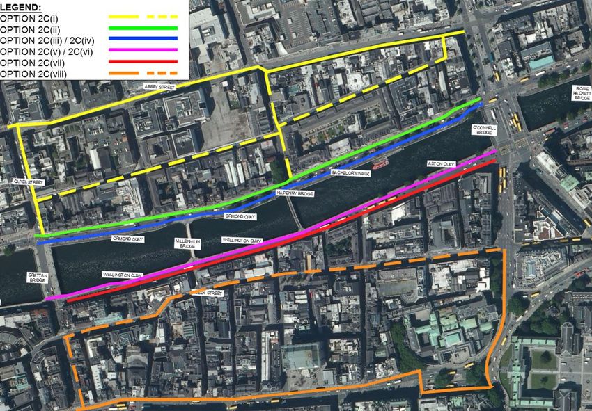
Roughan & O’Donovan                                                                                                                                                                    National Transport Authority
Consulting Engineers                                                                                                                                                Liffey Cycle Route Options Assessment Report

                8.2.2 Sub-Section 2B - O’Donovan Rossa Bridge to Grattan Bridge .................................. 31
                8.2.3 Sub-Section 2C - Grattan Bridge to O’Connell Bridge............................................... 33
                8.2.4 Combined Route Options through Section 2 ............................................................. 36
      8.3       Section 3: O’Connell Bridge to Memorial Bridge .................................................................. 37
      8.4       Section 4: Memorial Bridge to Tom Clarke Bridge ................................................................ 39
      8.5       Conclusion of Stage 2 Assessment...................................................................................... 39
9.    OPTIONS ASSESSMENT STAGE 3 ................................................................................. 40
      9.1       Introduction .......................................................................................................................... 40
      9.2       Section 1: Phoenix Park to Father Matthew Bridge .............................................................. 40
                9.2.1 Economic Criterion ................................................................................................... 41
                9.2.2 Integration Criterion .................................................................................................. 41
                9.2.3 Accessibility and Social Inclusion Criterion ............................................................... 42
                9.2.4 Safety Criterion......................................................................................................... 42
                9.2.5 Environment Criterion ............................................................................................... 42
                9.2.6 Section 1 - Conclusion.............................................................................................. 43
      9.3       Section 2: Father Matthew Bridge to O’Connell Bridge ........................................................ 43
                9.3.1 Economic Criterion ................................................................................................... 44
                9.3.2 Integration Criterion .................................................................................................. 44
                9.3.3 Accessibility and Social Inclusion Criterion ............................................................... 44
                9.3.4 Safety Criterion......................................................................................................... 44
                9.3.5 Environment Criterion ............................................................................................... 44
                9.3.6 Section 2 Conclusion ................................................................................................ 44
      9.4       Section 3: O’Connell Bridge to Matt Talbot Memorial Bridge ................................................ 45
                9.4.1 Economic Criterion ................................................................................................... 45
                9.4.2 Integration Criterion .................................................................................................. 45
                9.4.3 Accessibility and Social Inclusion Criterion ............................................................... 45
                9.4.4 Safety Criterion......................................................................................................... 45
                9.4.5 Environment Criterion ............................................................................................... 45
                9.4.6 Section 3 Conclusion ................................................................................................ 46
      9.5       Section 4: Matt Talbot Memorial Bridge to Tom Clarke East Link Bridge.............................. 46
10. OPTIONS ASSESSMENT STAGE 4 ................................................................................. 47
      10.1 Transition between Sections 1 and 2 ................................................................................... 47
      10.2 Section 3 - Transition between Sections 2 and 4 ................................................................. 47
      10.3 The Recommended Option .................................................................................................. 48

APPENDIX A                     Scheme Drawings

Note: The Authors acknowledge the use of imagery from Google Maps and Google Earth in the preparation of this report.

17.221.10 RP1                                                                                                                                          March 2019                                          Page iii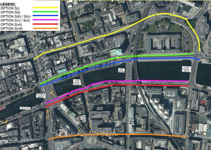
Roughan & O’Donovan                                                                                                                                                                                               National Transport Authority
Consulting Engineers                                                                                                                                                                           Liffey Cycle Route Options Assessment Report

EXECUTIVE SUMMARY                                                                                                          way cycle tracks alongside the river on both sides.
                                                                                                                     The scheme will provide full segregation of cyclists from other traffic along its length.
The Liffey Cycle Route has been an important objective of Dublin City Council [DCC} and the National
Transport Authority [NTA] and since 2013. Various studies have been undertaken to determine how                      The Liffey Cycle Route will be generally 2.0m wide for the one-way sections (except at unavoidable
best to advance Primary Route 5 of the Cycle Network Plan for the Greater Dublin Area. In 2017, DCC                  pinch-points), and 3.5m wide for the two-way sections. The scheme can be delivered with limited
and the NTA agreed that an independent assessment of all options previously considered as well as                    impacts on other road users and will benefit the busy bus corridor along this route where cyclists and
any new options that hadn’t been identified to date should be commissioned. The NTA appointed a                      buses currently mix. The scheme can be delivered with limited impacts on other road users in line with
consultant to undertake this assessment. This report presents the outcome of that detailed                           the Dublin City Development Plan (2016-2022).
assessment.
                                                                                                                     Previous studies of the Liffey Cycle Route project highlighted a number of specific pinch points along
The detailed route options assessment for the proposed River Liffey Cycle Route covered an area                      the River Liffey Quays, notably at Liam Mellowes and James Joyce Bridges, at Parliament St and
between the Phoenix Park to the west and Tom Clarke Bridge (East-Link) to the east, a length of almost               Essex Quay and at the Merchants Arch. The recommended scheme includes proposals to overcome
5km. The study considered route options across an area spanning from Parnell Street in the north of                  these constraints through sensitive interventions which are cognisant of the historic and protected
the city, to Thomas Street / Dame Street in the south. The study considered a variety of cycle facility              nature of city’s Quay Walls and Bridges.
types, including one-way and two-way options. Each option was considered in the context of its
feasibility, its capacity to deliver the scheme objectives, the associated traffic management issues, and            The scheme includes new boardwalks to improve capacity for pedestrians and the quality of the walking
its effects on the environment.                                                                                      environment along the corridor, while also enhancing the river environment as a public realm. Sections
                                                                                                                     of new and extended boardwalk will be necessary at a number of locations along the River Liffey
The objectives of the project were:                                                                                  corridor to provide sufficient width for all road users, in particular pedestrians. Some trees will have to
1.    To provide safe, continuous cycle facilities in both directions between the Phoenix Park /                     be removed along the corridor to accommodate the scheme, but compensatory landscaping will be
      Heuston Station and the Tom Clarke East Link Bridge, with a Quality of Service of A or A+,                     provided to mitigate the loss of existing trees along the corridor.
      where practicable;
2.    To comply with the National Cycle Manual; to be cognisant of the Principles of Sustainable
      Safety; and to meet the five needs of cyclists; and
3.    To be consistent with the National Cycle Policy Framework and the Transport Strategy for the
      Greater Dublin Area 2016 – 2035.

The scheme was considered in four sections along the course of the Lower River Liffey between the
Phoenix Park and the Tom Clarke East link Bridge. A detailed optioneering assessment was
undertaken for the western three sections:
•     Section 1: Phoenix Park to Father Matthew Bridge (Church St / Bridge St);
•     Section 2: Father Matthew Bridge to O’Connell Bridge; and
•     Section 3: O’Connell Bridge to Matt Talbot Memorial Bridge.

Previous plans for Section 4 from Matt Talbot Memorial Bridge to Tom Clarke East Link Bridge were
reviewed and found to already address the requirements of the Liffey Cycle Route project.

The conclusion of the assessment is that a 5km long Liffey Cycle Route from the Phoenix Park to the
East Link is feasible.
•     In the western section of the route, over a length of 2km the cycle tracks will be located on the
      buildings side of the traffic lanes.
•     In the busiest central section over a length of 1.2km, the cycle tracks will be located on the river
      side of the traffic lanes so as to avoid very busy bus stops on the buildings side of the road.
•     The final eastern section over a distance of 1.8km through the Docklands will consist of two-

17.221.10 RP1                                                                                                March 2019                                                                                                               Page iv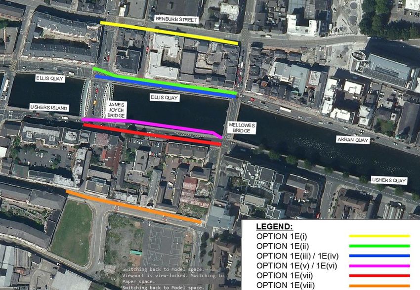
Roughan & O’Donovan                                                                                                                            National Transport Authority
Consulting Engineers                                                                                                        Liffey Cycle Route Options Assessment Report

1.         INTRODUCTION

           Roughan & O’Donovan was engaged by the National Transport Authority to carry out a review of
           the proposed Liffey Cycle Route and to prepare an Options Assessment Report, which should
           consider all possible options, including but not limited to those considered in earlier studies.
           Options considered must in all instances be respectful of the sensitive receiving environment
           and changing urban landscape. This report presents a summary of the earlier work, additional
           options considered, and a route options appraisal leading to the Recommended Option.

           The River Liffey corridor is:
           •     Is a critical public transport corridor through the city centre, and also facilities access for
                 deliveries and car parking;
           •     Is an important route for cycling which has seen significant growth along this corridor while
                 also seeing a continuing decline in private car use;
           •     Is an important ecological corridor through Dublin City Centre’s built environment;
           •     Has significant commercial and retail activity;
           •     Is a valuable amenity for its residential communities, sporting interest groups, and tourists
                 alike;
           •     Is an important heritage corridor, housing many of the city’s most iconic and important
                 landmark buildings and bridges, and its historic quay walls; and
           •     Is a primary utilities corridor carrying underground trunk services.

           The proposed Liffey Cycle Route aims to serve the significant1 and increasing cycling demand
           that exists through Dublin City Centre and will connect the other principal radial cycling routes
           into the city centre and will improve the cycling and pedestrian environment. This will have
           significant benefits both for citizens and tourist alike and will make the city centre and the
           Phoenix Park more accessible for all.

           The following information was available to the Project Team to inform the Options Assessment
           process:
           •     Topographical Surveys;
           •     Extensive, multi-annual traffic count data;
           •     Collision Data2;
           •     Geotechnical Information for recent projects;
           •     Planning Records;
           •     Utility and Service Records; and
           •     Desktop Heritage Studies prepared for earlier Study.

1   Refer to 2018 May and November City Centre Count Data published by Dublin City Council
2   Road Safety Authority Collision Data - RSA

17.221.10 RP1                                                                                                  March 2019                                          Page 1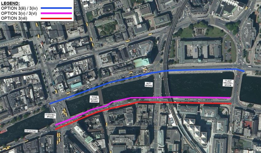
Roughan & O’Donovan                                                                                                                                                                                           National Transport Authority
Consulting Engineers                                                                                                                                                                       Liffey Cycle Route Options Assessment Report

2.         CONTEXT                                                                                                         Dublin City Council’s Development Plan (2016 – 2022)4 incorporates the roll-out of the GDA
                                                                                                                           Cycle Network Plan, including the proposed Liffey Cycle Route. It further identifies the need for
                                                                                                                           public realm enhancements along the river corridor.
2.1        Need for the Scheme
           The need for the Liffey Cycle Route was identified in the Greater Dublin Area [GDA] Cycle               2.2     Existing Facilities
           Network Plan (2013)3, and is incorporated into the approved National Transport Authority
                                                                                                                   2.2.1   North Quays
           Greater Dublin Area Transport Strategy (2016 – 2035). The route is designated as Primary
           Corridor No.5, a west – east route between Parkgate Street and the Point Roundabout, along                      Existing cycle facilities along the Liffey Quays are inconsistent and discontinuous. There are
           the Liffey Quays. The proposed Liffey Cycle Route will intersect several other Primary and                      sections of on-road cycle lane on the north quays between Heuston Station and O’Connell
           Secondary cycle routes identified in the GDA Cycle Network Plan.                                                Bridge. Cycle lane facilities exists along the building side only and varies between one-way on-
                                                                                                                           road cycle lane and shared bus lane in the west to east direction only. Where a cycle lane is
           The objectives of the project are as follows:                                                                   marked, it varies between mandatory (solid line) and advisory (dashed line). There are
                                                                                                                           numerous interactions with bus stops, parking bays, and left turning vehicles, which present
           1.     To provide safe, continuous cycle facilities in both directions between the Phoenix Park /
                                                                                                                           frequent hazards for cyclists. Furthermore, it is difficult for cyclists on the Quays to access the
                  Heuston Station and the Tom Clarke East Link Bridge, with a Quality of Service of A or A+,
                                                                                                                           opposite side of the river, as a result of the current traffic regime, banned turns and one-way
                  where practicable;
                                                                                                                           streets and bridges. This results in illegal manoeuvres being made at various locations, as
           2.     To comply with the National Cycle Manual; to be cognisant of the Principles of Sustainable               evidenced by the traffic count data5.
                  Safety; and to meet the five needs of cyclists; and
           3.     To be consistent with the National Cycle Policy Framework and the Transport Strategy for                 Similarly, between O’Connell Bridge and Butt Bridge, the cycle lane is only present in the west
                  the Greater Dublin Area 2016 – 2035.                                                                     to east direction along the buildings side and is demarcated as advisory, with significant
                                                                                                                           interaction with bus stops, parking bays and a heavy two-lane left turn to Beresford Place and
                                                                                                                           Gardiner Street Lower. Between Butt Bridge and Memorial Bridge, the cycle lane is mandatory
                                                                                                                           and is interrupted by one bus stop at the Custom House. Some cyclists also use the very wide
                                                                                                                           footpath along the river side of the north quays between Butt Bridge and Matt Talbot Memorial
                                                                                                                           Bridge to gain access to and from the Dublinbikes station, in the absence of a formal cycle
                                                                                                                           facility.

                                                                                                                           Between Matt Talbot Memorial Bridge and the Point Roundabout, the on-road cycle facility along
                                                                                                                           the building side of the north quays varies between predominately advisory and shared with the
                                                                                                                           bus lane. There are no cycle or bus lane facilities through the pinch-points at the two Scherzer
                                                                                                                           Bridges, located at Spencer Dock and George’s Dock. Along the river side of this section of the
                                                                                                                           North Quays, there is an additional cycle facility which varies between two-way off-road
                                                                                                                           (between Samuel Beckett Bridge and the Point Roundabout), one-way off-road in the east-west
                                                                                                                           direction (between Matt Talbot Memorial Bridge and Samuel Beckett Bridge) and on road
                                                                                                                           shared with buses in the east-west direction where pinch points exist. Three particular pinch-
                                                                                                                           points exist along this facility, at the Dublin City Council Docklands office, at the commercial
                                                                                                                           pods opposite Excise Walk and at the Spencer Dock Scherzer Bridge. The alignment of the
                                                                                                                           cycle track is poor, and usage is restricted by the discontinuities and poor access to and from
                                                                                                                           the route.

                                                                                                                           The means of assessing the Quality of Service of cycling facilities is outlined in the National
                                                                                                                           Cycle Manual6. Using these criteria, the Quality of Service of the existing facilities is D – the
           Figure 2.1         Dublin City Centre Cycle Network Plan [Extract from GDA Cycle Network Plan]                  lowest level.
                              with Liffey Cycle Route highlighted]

                                                                                                                   4 www.dublincity.ie/main-menu-services
                                                                                                                   5 Traffic Count Data – June 2018 published by Dublin City Council
3                                                                                                                  6 https://www.cyclemanual.ie/manual/thebasics/quality/
    www.nationltransport.ie/wp-content

17.221.10 RP1                                                                                              March 2019                                                                                                             Page 2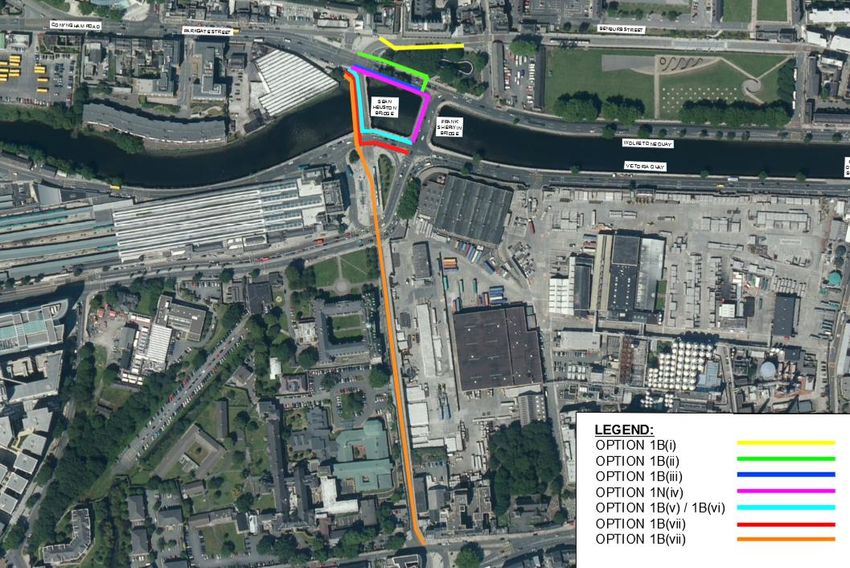
Roughan & O’Donovan                                                                                                                                                                                                             National Transport Authority
Consulting Engineers                                                                                                                                                                                         Liffey Cycle Route Options Assessment Report

2.2.2      South Quays                                                                                                           •      Section 2: Father Matthew Bridge to O’Connell Bridge;
           Along the south quays, there are no dedicated cycle facilities available between Heuston Station                      •      Section 3: O’Connell Bridge to Matt Talbot Memorial Bridge;
           and O’Connell Bridge and cyclists share the bus lanes, which have some gaps in continuity.
                                                                                                                                 •      Section 4: Matt Talbot Memorial Bridge to Tom Clarke East Link Bridge (the Point).
           Victoria Quay is noted for its particular hostile environment, with multiple lanes, high speeds and
           significant weaving and lane indiscipline. Cyclists wishing to access Heuston Station and those
                                                                                                                                 Current data shows demand through Section 1 is generally linear from the western suburbs
           wishing to travel north towards Parkgate Street and the Phoenix Park have to negotiate these
                                                                                                                                 towards the city centre. The new Technical University of Dublin [formerly DIT] campus at
           hostile conditions. The intersection of Parliament St and Essex Quay is an area where
                                                                                                                                 Grangegorman will also be accessed from this section.
           improvement is required, as two general traffic lanes offer no protection to cyclists through this
           section. The limited available width and weaving manoeuvres between vehicles, particularly at
                                                                                                                                 Through Section 2 – the historic city centre, turning demand increases with the increasing
           bus stops, taxi ranks, and loading bays makes the environment unattractive for cycling -
                                                                                                                                 number of trip attractors and other routes on each side of the river.
           especially for inexperienced and slow moving cyclists.
                                                                                                                                 In Section 3 – the core city centre, all of the city’s transit modes come together, and light rail,
           Further east from O’Connell Bridge to Matt Talbot Memorial Bridge, the cycle facilities are
                                                                                                                                 buses, bicycles, pedestrians, deliveries, taxis and private cars all compete for limited road space
           generally advisory, which allows other vehicles to weave across the cycle route to bus stops,
                                                                                                                                 and priority. The amount of time that can be apportioned to any given mode or direction is
           parking/loading facilities, and left turns.
                                                                                                                                 constrained by these competing demands through this congested section. Through cycling
                                                                                                                                 demand flows along the river corridor are marginally lower through this section, however north-
           From Matt Talbot Memorial Bridge to Samuel Beckett Bridge a two-way segregated cycle track
                                                                                                                                 south cycling flows are significantly higher resulting in a greater overall number of cyclists.
           has been implemented by Dublin City Council, following adjacent to the river side footpath on
           the south side of the river.
                                                                                                                                 Section 4, the Docklands, is the area of the city experiencing the greatest quantum of
                                                                                                                                 development and, consequently, cycling demand. Many of the new developments in this area
           Given the inconsistencies and discontinuities in cycle facility provision along the south quays,
                                                                                                                                 include little or no provision for private cars, and this will necessitate a large proportion of their
           the Quality of Service of the existing facilities is D – the lowest level.
                                                                                                                                 occupants travelling to and from the area by bicycle.

2.3        Demand
                                                                                                                     2.4         Collision Data
2.3.1      Cycling Flows
                                                                                                                                 A review of historic accident data along the River Liffey Corridor was undertaken to inform this
           The Cycle Network Plan for the Greater Dublin Area published in 2013 included an extensive                            study. The Road Safety Authority Collision Database9 was interrogated. Data from 2005 – 2015
           assessment of the [then] current cycling flows across the Greater Dublin Area, and the projected                      was analysed for incidents involving cyclists and for other modes.
           2021 flows7. More recent survey data8 indicates that the projected 2021 bicycle traffic flows
           along the River Liffey corridor have been exceeded already [2018] and that demand continues
                                                                                                                                                                                                                   No. Serious             No. Minor
           to grow, even with the current limited dedicated infrastructure provision. This could be due to                            Location              Mode           No. Incidents         No. Fatal
                                                                                                                                                                                                                    Injuries                Injuries
           factors such as the continuing success of the Dublinbikes scheme, the Bike to Work tax saver
           scheme, the HGV canal cordon ban, and increased public awareness of the societal benefits                                                     Cyclist Only            58                  3                    5                     50
                                                                                                                                     Liffey Quays
           associated with cycling.                                                                                                                       All Modes             330                 10                    42                   278

           In demand terms, the GDA Cycle Network plan expected AM peak (7am – 10am along
                                                                                                                                 The incident data showed that 18% of all incidents on the Liffey Quays involved cyclists despite
           Bachelors’ Walk) to exceed 900 cyclist by 2021. Traffic counts from June 2018 shows, cycling
                                                                                                                                 cyclist demand historically representing a lower percentage of total demand.
           numbers in excess of 1080 (compared to 950 private cars). Even the absence of any
           infrastructure improvement (which the GDA Cycle Network Plan assumed), it is reasonable to
           assume that cycle trips will continue to increase further.

2.3.2      Movement Patterns
           In broad terms, movement patterns along the River Liffey corridor can be broken into four
           distinct sections:
           •     Section 1: Phoenix Park to Father Matthew Bridge (Church Street);

7   https://www.nationaltransport.ie/wp-content/uploas/2014/04/Cycling_Demand_Maps11.pdf
8                                                                                                                    9
    Refer to 2018 May and November City Centre Count Data published by Dublin City Council                                http://www.rsa.ie/en/RSA/Road-Safety/Our-Research/Collision-Statistics/Ireland-Road-Collisions/

17.221.10 RP1                                                                                                March 2019                                                                                                                              Page 3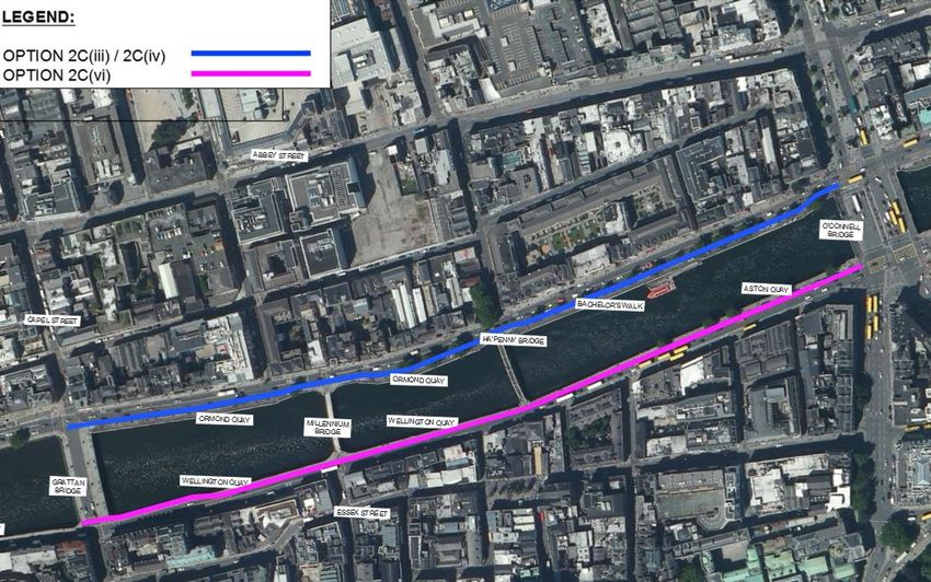
Roughan & O’Donovan                                                                                           National Transport Authority
Consulting Engineers                                                                       Liffey Cycle Route Options Assessment Report

        Figure 2.2     Sample of Collision Data Statistics from RSA Website

17.221.10 RP1                                                                 March 2019                                          Page 4
Roughan & O’Donovan                                                                                                                                                                                     National Transport Authority
Consulting Engineers                                                                                                                                                                 Liffey Cycle Route Options Assessment Report

3.      EARLIER STUDY                                                                                                  Option 2:   Two-way riverside facility on the north quays with buses rerouted via Benburb
                                                                                                                                   Street between Liffey Street West and Church Street, and upgrade of the existing
        A previous commission for Dublin City Council [DCC] looked at various options for the Liffey                               one-way on-road facility on the south quays;
        Cycle Route [Liffey Cycle Route].                                                                              Option 3:   As Option 2, but with Croppy’s Acre Park moved to riverside, with cycleway and
                                                                                                                                   traffic lanes diverted between it and the Luas line, and upgrade of the existing one-
3.1     Initial List of Options Considered                                                                                         way on-road facility on the south quays; and
        The following options were initially considered:                                                               Option 4:   One-way on-road building – side cycling facilities on each quay.
        1)      Do Nothing;                                                                                                        This option raised concerns primarily due to the significant interactions between
        2)      Two-way riverside North Quays;                                                                                     buses and cyclists that would arise along the corridor.

        2a)     Two-Way riverside North Quays with Bus Re-routing;
                                                                                                                       The feedback from the public consultation was generally positive towards the proposed Liffey
        3)      Two-way riverside South Quays;                                                                         Cycle Route in principle, but comments were received from various stakeholders and interest
        4)      One-way riverside Both Quays;                                                                          groups raising concerns about each of the options presented. Further studies were undertaken
                                                                                                                       on foot of the feedback to the public consultation process.
        5)      Two-way riverside North Quays with boardwalks;
                                                                                                                       Option 5:   Two-way cycle route north of Croppy’s Acre and along Benburb Street and
        6)      Two-way riverside South Quays with boardwalks;
                                                                                                                                   Hammond Lane to Church Street, continuing east on the north quays from there,
        7)      Two-way North Side Parallel Route;                                                                                 and upgrade of the existing one-way on-road facility on the south quays;
        8)      Two-way South Side Parallel Route;                                                                     Option 6:   Combination of Option 1 and Option 3, with buses returning to the quays at Queen
        9)      Two-way riverside South Quays from Heuston Station to Father Mathew Bridge, Two-way                                Street, and a boardwalk along Arran Quay only, and upgrade of the existing one-
                riverside North Quays from Fr Matthew Bridge to the Campshires;                                                    way on-road facility on the south quays; and
        10)     Two-way riverside North Quays with limited boardwalk (Arran Quay & Ellis Quay);
                                                                                                                 3.3   Shortlisted Options
        11)     Two-way riverside South Quays with limited boardwalk (Essex Quay & Wellington Quay);
                                                                                                                       Following feedback from the public consultation and stakeholder engagement processes, two
        12)     One-way riverside North and South Quays with limited boardwalk (Arran Quay, Ellis Quay,
                                                                                                                       further options were developed and these were shortlisted for the Recommended Option:
                Essex Quay & Wellington Quay); and
                                                                                                                       Option 7:   Two-way riverside cycle route along the north quays with no private vehicular traffic
        13)     One-way Both Quays on Building Side of Quays.
                                                                                                                                   along Ellis and Arran Quays. Traffic rerouted via Blackhall Place, North King St,
                                                                                                                                   Brunswick St and Church St, and upgrade of the existing one-way on-road facility
        The analysis of these options resulted in a shortlist being prepared for further presentation and
                                                                                                                                   on the south Quays.
        consultation. The criteria used in that shortlisting exercise were:
                                                                                                                                   A two-way segregated cycling facility along the north Quays was examined in
        i)      Quality of Service for Cyclists;
                                                                                                                                   detail, with various proposals emerging to overcome a significant pinch-point at
        ii)     Network Efficiency;                                                                                                Ellis and Arran Quays. In all the options, the solutions presented to the pinch-point
        iii)    Environmental Quality;                                                                                             at Ellis and Arran Quays remained a concern, and a further variant option was
        iv)     Cost;                                                                                                              added for assessment purposes:

        v)      Technical Risk; and                                                                                    Option 8:   Two-way facility on the north Quays with a limited section of boardwalk along Ellis
                                                                                                                                   Quay and Arran Quay – i.e. between James Joyce and Father Matthew Bridges,
        vi)     Operation and Maintenance Issues
                                                                                                                                   and upgrade of the existing one-way on-road facility on the south Quays. A bus
                                                                                                                                   gate was proposed upstream of Liam Mellowes Bridge.
3.2     Options Shortlisted for Public Consultation
        Following initial assessment, four options were shortlisted for public consultation in March 2015,       3.4   Concerns Regarding the Shortlisted Options
        and renumbered as:
                                                                                                                       Concerns remained associated with the following:
        Option 1:       Two-way riverside facility on the north quays with a limited section of boardwalk
                                                                                                                       •    The diversion of bus lanes from the quays;
                        along Ellis Quay and Arran Quay – i.e. between James Joyce and Father Matthew
                        Bridges, and upgrade of the existing one-way on-road facility on the south quays;              •    Proposals to divert traffic from the quays;
                                                                                                                       •    Proposals to divert cyclists from the riverside; and

17.221.10 RP1                                                                                            March 2019                                                                                                         Page 5
Roughan & O’Donovan                                                                                                                      National Transport Authority
Consulting Engineers                                                                                                  Liffey Cycle Route Options Assessment Report

        •       Finding feasible solutions at constrained junctions, where bridge parapets and higher road
                levels prevent the increased cross-sectional area (provided by the boardwalk being
                extended through the junctions).

        On foot of these concerns, a preferred option did not emerge from the earlier study.

17.221.10 RP1                                                                                            March 2019                                          Page 6
Roughan & O’Donovan National Transport Authority
Consulting Engineers Liffey Cycle Route Options Assessment Report
4. TERMS OF REFERENCE FOR CURRENT COMMISSION 4.3 Additional Developments since Earlier Study
The baseline environment for the current study has changed since the earlier studies were
The National Transport Authority [NTA], following a public procurement process, appointed a undertaken, and the following changes in the intervening period were considered by the current
team of consultants led by Roughan & O’Donovan to undertake an independent assessment of commission:
the Liffey Cycle Route. 1) Enhancements to bus lanes implemented by Dublin City Council on the north and south
quays between Grattan Bridge and O'Connell Bridge (introduced in 2017);
4.1 The Brief
2) The introduction of Luas Cross City across O’Connell and Rosie Hackett Bridges; and
The key requirements for the current study are:
3) BusConnects proposals, which, if implemented, would result in significant changes to bus
1) Review all previous options considered; routes and facilities throughout Dublin.
2) Review all baseline information, and reappraise constraints and design assumptions;
3) Set and define clear project objectives; Other considerations included:
4) Identify and prepare outline designs for any options not considered to date; 4) Proposed construction of pedestrian and cycle bridges on campshires at Spencer Dock
(Royal Canal);
5) Undertake a comprehensive Options Assessment, and prepare an Options Assessment
Report (this report); and 5) Proposed Pedestrian / Cycle bridge(s) in the docklands between Samuel Beckett Bridge
and the Tom Clarke East Link Bridge; and
6) Prepare a conceptual design for the Recommended Option.
6) The advancement of the Dodder Gut Bridge; and
The commission also includes stakeholder consultation and the role of Project Supervisor 7) The implementation of flood defences and associated cycling facilities in the docklands.
Design Process10.
4.4 Methodology for Options Assessment
4.2 Proposed Study Area This report presents a four-stage Options Assessment, comprising the following steps:
The Study Area for the project encompassed the area between the green and blue lines on Stage 1: Feasibility Screening
Figure 4.1 between the Phoenix Park and the Tom Clarke East Link Bridge:
Consider high-level options, including do-nothing, reversal of traffic on the quays,
etc. The purpose of this step was to eliminate options that cannot meet the scheme
objectives.
Stage 2: High Level Impact Assessment
This stage assessed each individual section of the corridor to determine whether
scheme options could be geometrically accommodated in the context of the nature
and scale of the likely associated environmental impacts.
Stage 3: Common Appraisal Framework Assessment
Link the various possible options for each section of the corridor and carry out a
multi-criteria analysis using the Common Appraisal Framework (CAF) for Transport
Project, published by DTTAS.
This stage compares the options that emerge from Stage 2 under the CAF
Figure 4.1 Study Area
headings:
The study area is sufficiently wide to allow the consideration of parallel routes as far north as • Economy;
North King Street / Parnell Street and as far south as Thomas Street / Dame Street. The Study • Integration;
Area did not extend further to avoid overlapping with other separate cycling routes proposed
• Accessibility and Social Inclusion;
under the GDA Cycle Network Plan.
• Safety;
• Physical Activity; and
• Environment.
10 www.hsa.ie
17.221.10 RP1 March 2019 Page 7Roughan & O’Donovan National Transport Authority
Consulting Engineers Liffey Cycle Route Options Assessment Report
Stage 4: Link the sections together to complete the end-to-end route. Review the individual
section outcomes to ensure the best overall route emerges.
It was assumed for the purposes of this assessment that, subject to space for the facility itself
being available, engineering solutions could be achieved to turning manoeuvres at junctions for
each type of facility, and these issues would be dealt with at the latter stages of the assessment
process.
17.221.10 RP1 March 2019 Page 8Roughan & O’Donovan National Transport Authority
Consulting Engineers Liffey Cycle Route Options Assessment Report
5. DESIGN PRINCIPLES AND ASSUMPTIONS route from the frontage buildings and adjoining areas along the side streets. This situation
enables ease of access and integration with the surrounding area.
The proposed Liffey Cycle Route will provide a high quality central spine cycleway through
Dublin City Centre and is needed in response to the growing volumes of cyclists to and through Where a cycle track is positioned on the right-hand side of the traffic carriageway, this can make
the city. Demand along the corridor is already high11, and likely suppressed by the poor existing it difficult for cyclists to join and leave the route from the surrounding area, other than at main
cycling environment. Demand will increase in the coming years, as significant new junctions with traffic signals or dedicated signal crossings. Such an arrangement is less than
developments come onstream, particularly in the docklands and the Grangegorman optimal in terms of access and integration for cyclists.
Technological University Dublin [formerly DIT] campus.
The default preference arrangement should therefore be to locate the cycle track along the left
The following design criteria have been assumed for the option assessment process: side of the traffic route, especially where the traffic flows, including buses and taxis, are high and
there is more than one lane to cross.
5.1 Quality of Service
5.4 Transitions
The Liffey Cycle Route shall generally have a Quality of Service A or A+ 12. The Quality of
Service of any given section shall not be lower than B. This will facilitate the usage of the route Over the 5km length of the Liffey Cycle Route between the Phoenix Park and the Tom Clarke
by cyclists of all ages and abilities. East Link Bridge, there are variable conditions that may require different configurations for the
proposed cycle facilities. Different layouts may be preferred in different sections of the route. In
5.2 Segregation that case it will be necessary to arrange suitable transitions so that the overall route can be fully
integrated for optimal operation for cyclists. Any necessary transition arrangements will be dealt
Cyclists, insofar as possible, shall be segregated from all other modes of traffic including, in
with at the latter stages of the assessment process as the preferred layouts in each section of
particular larger vehicles such as HGVs, buses and trams13. At bus stops with high-frequency
the route emerge.
services it is highly desirable to separate cyclists from bus boarding and alighting by passengers
as advised in the National Cycle Manual.
5.5 Width
The Liffey Cycle Route will experience very heavy usage at peak times, as is currently the case.
Sections of the route will see heavy tidal eastbound demand in the morning towards the city
centre and docklands which is a major new and rapidly growing employment zone, with a similar
return movement westward in the evening. As such, the guidance of the National Cycle Manual
should be taken as a minimum provision, and the general objective is to provide a 2.0m
minimum width for one-way facilities, and a 3.5m minimum width for two-way facilities14.
Relaxations below this should only be considered locally, and avoided in the busier central and
eastern sections, if at all practicable.
Further detailed analysis of provisions at junctions will be required at a later stage of the design
process, particularly in the case of any proposed two-way facilities, which require a greater
Detail from NCM Page 160 number of movements to be accommodated. The National Cycle Manual suggests that all cycle
facilities should be widened by 0.5m at junctions to account for cyclist wobble on take-off. This
Along the River Liffey in the busiest city centre section where space is restricted, it is unlikely will be accommodated where practicable. However, along the river corridor, space is most
that segregation can be achieved at bus stops. This will reduce the feasibility of locating constrained at junctions, where historic bridge parapets present an additional impediment and a
segregated cycle tracks along the buildings side of the street where direct conflicts would arise detail assessment will be required at the preliminary design stage.
at some of the busiest bus stops in the city,
5.6 Impact on other Modes of Transport
5.3 Integration and Access The impact of each option for the Liffey Cycle Route on other modes of transport in terms of
The conventional arrangement for cycle lanes / tracks is to follow the left edge of the traffic diversion effects, capacity, etc. will need to be assessed and minimised where possible. Access
carriageway alongside the footpath or verge. This allows direct access to and from the cycle to premises will have to be maintained in line with Dublin City Council’s obligations. In particular,
the needs of pedestrians need to be considered carefully.
11 2018 Traffic Data – Dublin City Council
12 www.cyclemanual.ie – Pg 10
13 https://www.cyclemanual.ie/manual/thebasics/mixed/ 14 https://www.cyclemanual.ie/manual/thebasics/width/
17.221.10 RP1 March 2019 Page 9Roughan & O’Donovan National Transport Authority
Consulting Engineers Liffey Cycle Route Options Assessment Report
5.7 Existing Facilities and Street Furniture
It is assumed that all existing street furniture and facilities, including Dublin-Bikes stands, bus
stops, loading bays, trees, and taxi ranks, can be reorganised to accommodate the Liffey Cycle
Route. It is assumed that existing on-street parking may be curtailed or removed completely,
where the available street space would be more appropriately used for the benefit of
pedestrians, cyclists, landscaping, or public transport.
5.8 Availability
The route should generally be accessible and usable 24 hours a day, 365 days a year, in all
normal weather conditions.
5.9 Junction Controls
The Liffey Cycle Route will interact with traffic at junctions and accesses. In keeping with the
National Cycle Manual, the Recommended Option will seek to minimise the frequency of these
conflicts, and the extents of possible delays, in order to optimise the Quality of Service for
cyclists.
17.221.10 RP1 March 2019 Page 10Roughan & O’Donovan National Transport Authority
Consulting Engineers Liffey Cycle Route Options Assessment Report
6. CONSTRAINTS 16. Sean O’Casey Bridge (Pedestrian): Modern;
17. Samuel Beckett Bridge (Guild Street): Modern; and
The following is a summary of the principal constraints to be considered in identifying and 18. Tom Clarke / East Link Bridge: Modern.
assessing options for the proposed Liffey Cycle Route.
Impacts on historic bridges that are protected structures and modern iconic bridges should
6.1 Ecology generally be avoided. Sensitive minor alterations may be feasible in certain instances, similar to
Dublin Bay is located 2.5km east of the eastern end of the scheme, and is designated as a the earlier intervention at Grattan Bridge, where the Liffey Boardwalk was tied into the bridge by
Special Protection Area, Special Area of Conservation, Natural Heritage Area and UNESCO removing a section of the parapet.
Biosphere. Any in-stream works within the River Liffey for the construction of boardwalk
structures will require avoidance and/or mitigation measures to prevent any spillages into the The Liffey Quay Walls are noted for their granite block construction and are protected structures.
river that could affect the downstream sensitivities. Similar works have been successfully Any works proposed to these will require careful consideration. The existing quay walls may be
managed for several modern bridges over the river and the current pedestrian boardwalks. in need of rehabilitation in places, and proposals for new boardwalks or bridges may necessitate
Therefore, the assessment assumes boardwalks can be provided where necessary. additional remedial works. Any such works would need to take account of the downstream
ecological sensitivities.
6.2 Architecture
The River Liffey bisects the heart of Dublin City, and the buildings and bridges along her provide 6.3 Archaeology
an essential aspect of the City’s character. The buildings along the route of the proposed There has been human activity along the River Liffey in Dublin City for over 1,000 years. As
scheme vary from Georgian terraces in the central section to modern icons such as the National such, there is considerable archaeological potential where any significant invasive works are
Conference Centre at the eastern end. Various landmark buildings perforate the route, including proposed – such as the realignment of quay walls, or the construction of new bridges. Minor
the Customs House and the Four Courts. Any impacts on the built heritage of the city has to be surface interventions, such as the realignment of kerb lines, are unlikely to cause any
carefully assessed, and extensive demolition of buildings must be avoided in any Liffey Cycle archaeological disturbance, since historic fabric has already been removed for roadworks,
Route proposal. Isolated impacts on unremarkable, non-listed buildings may be required, services and the like.
subject to not affecting the overall character of the area, and in the absence of better
alternatives. 6.4 Landscape and Visual
The River Liffey and associated buildings and bridges are an iconic feature of Dublin. The views
There are 18 bridges along this section of the River Liffey, including historical bridges, ordinary along the river feature are sensitive to change. However, there have been significant
modern types and some iconic Dublin landmark structures. These are: interventions over the years, including boardwalks, additional bridges, and most recently the
1. Sean Heuston Bridge (Luas): Historic & Protected Structure; Rosie Hackett Bridge. New bridges, boardwalks or quay wall realignments would have to be
2. Frank Sherwin Bridge: Modern; carefully detailed to complement rather than detract from their surroundings.
3. Rory O’More Bridge (Watling Street): Historic & Protected Structure;
Existing trees along the river provide an element of greening in an otherwise hard landscape,
4. James Joyce Bridge (Blackhall Place): Modern; notwithstanding their potential negative impact on footpath accessibility. It is desirable that the
5. Liam Mellowes Bridge (Queen Street): Historic & Protected Structure; existing trees should be retained, where practicable. Where this is not possible, replacement
appropriate planting should be integrated in the design proposals. Proposals for the docklands
6. Father Matthew Bridge (Church Street): Historic & Protected Structure;
area [i.e. east of Memorial Bridge] should have regard to the Public Realm Masterplan for the
7. O Donovan Rossa Bridge (Winetavern Street): Historic & Protected Structure; area.
8. Grattan Bridge (Capel Street): Historic & Protected Structure;
9. Millennium Bridge (Pedestrian): Modern; Where significant interventions are proposed, and major roadworks are required, the public
realm should be enhanced in keeping with Dublin City Council’s Public Realm Strategy15.
10. Ha'penny Bridge (Pedestrian): Historic & Protected Structure;
11. O’Connell Bridge: Historic & Protected Structure; 6.5 Physical Infrastructure
12. Rosie Hackett Bridge (Marlborough Street): Modern; Existing physical infrastructure, including roadways, quay walls, street lighting, and services, will
13. Butt Bridge (Tara Street): Historic; be constraints to the delivery of the proposed scheme. The River Liffey corridor is a major
14. Beresford Place (Loop Line) Bridge (Elevated Railway): Historic & Protected Structure; conduit for transmission gas, collector sewers, and major watermains, etc. Impacts on major
services should be minimised where practicable, since realignment works may be costly and
15. Matt Talbot Memorial Bridge: Modern;
15 http://www.dublincity.ie/sites/default/files/content/Planning/Documents/YDYVPublicRealmFinal.pdf
17.221.10 RP1 March 2019 Page 11Roughan & O’Donovan National Transport Authority
Consulting Engineers Liffey Cycle Route Options Assessment Report
disruptive. There are also a number of services crossing beneath the river, including two
services tunnels in the vicinity of the Tom Clarke East Link Bridge, and a sewerage siphon at
Rosie Hackett Bridge. Impacts on these should be avoided.
6.6 Traffic
The maintenance of access and circulation, both during and after construction, are significant
constraints to the delivery of the proposed Liffey Cycle Route. The Liffey quays are a critical
artery for transport into and out of the city, particularly public transport. In recent years, the
priority afforded to private cars along the Liffey quays has diminished. However, the quays
remain a critical element in Dublin’s access, servicing, and circulation network.
6.7 People
The assessment of options will have to consider the impact on people. Access to residences,
businesses and services will have to be maintained in the Recommended Option.
6.8 Other Plans and Policies
The Liffey Cycle Route scheme proposals will have regard to other plans and policies for the
city, including, inter alia:
1) Dublin City Development Plan;
2) Dublin City Council Public Realm Strategy;
3) Dublin City Council City Centre Transport Study;
4) Grand Canal and North Lotts SDZ;
5) Docklands Public Realm Masterplan; and
6) Poolbeg SDZ.
6.9 Other Projects
The Liffey Cycle Route scheme proposals will have regard to other projects along and adjacent
to the corridor, including:
1) Proposed Dodder Public Transport Bridge;
2) BusConnects proposals for bus lane enhancements;
3) Various bridge proposals in the docklands;
4) Proposed and ongoing flood defence works;
5) Proposed upgrade of Point Roundabout; and
6) Major planning applications along the route.
17.221.10 RP1 March 2019 Page 12Roughan & O’Donovan National Transport Authority
Consulting Engineers Liffey Cycle Route Options Assessment Report
7. OPTIONS ASSESSMENT STAGE 1 – FEASIBILITY SCREENING 2B Segregated Cycle Tracks
Segregation of cyclists from general traffic and buses would be provided in this option. However,
An initial assessment of the possible macro-level options for the proposed Liffey Cycle Route interactions at bus stops would have to be considered and addressed. Many recent schemes
was carried out to determine whether there may be a more appropriate network level solution for including Braemor Road, Old Blessington Road, and Frascati Road schemes have
the Liffey Cycle Route than the assumed provision of (a) cycle way(s) along the River Liffey demonstrated that segregated left hand side cycle tracks can be engineered to provide an
corridor with the substantial retention of existing traffic and public transport arrangements. appropriate Quality of Service, while addressing the conflicts at bus stops.
This option is considered to be potentially feasible, subject to design.
The Stage 1 Assessment constitutes an exercise to eliminate options that have fundamental and
irreconcilable issues with the objectives of the project that are set out in Section 2.1 of this 7.3 Network Option 3: One Way Riverside Cycle Tracks on North and South Quays
report.
This option would provide a one-way segregated riverside cycleway on both sides, avoiding the
interactions at bus stops involved with Option 2. It also will have fewer traffic interactions (and
7.1 Network Option 1: Do-Nothing Scenario
fewer direct connections) at side-streets between the main junctions. It is assumed that the
This option proposes to maintain the existing facilities as described in Section 2.2. The existing cycle tracks would follow the existing direction of traffic on the quays, but the facility could be
facilities have Quality of Service of D, the lowest level. The Do Nothing option would therefore operated in either direction subject to design. It would also position the cyclists next to the less
not achieve the objectives of the scheme. busy riverside footpath, with less possibility of interference from pedestrians. However, this
This option is not considered further. option would be more difficult to access from minor side streets between bridge crossings.
This option is considered to be potentially feasible, subject to design.
7.2 Network Option 2: One-way Building Side cycle facility on North and South Quays
2A On-Road Cycle Lanes 7.4 Network Option 4: Two-way Cycle Track on North Quays – Building Side
This option proposes new or improved conventional one-way on road cycle lanes on the left- This option would increase the complexity of interactions at junctions and accesses - it would be
hand side of the road carriageway on both quays. In accordance with the Guidance Graph from difficult for other vehicles to turn left across such a facility in an uncontrolled manner. Further, it
the National Cycle Manual (as shown below) on a street with AADT greater than 10,000, would give rise to particular safety concerns at bus stops, the third of the five Principles of
segregation is required. The AADT at Arran Quay is in excess of 14,000. Sustainable Safety17 is legibility, particularly requiring that all potential conflicts are obvious and
The option for cycle lanes is therefore not considered further. the resolution of the conflict is mutually understood by all road users. It also requires that all
road users are instinctively aware of the expected position and likely behaviour of all other road
users. This would not be the case with this option for the proposed Liffey Cycle Route.
This option would therefore not achieve the objectives of the scheme and, on that basis, it is
not considered further.
7.5 Network Option 5: Two-way Riverside Cycle Track on North Quays
This option would provide a two-way segregated cycleway alongside the river on the north side.
This arrangement would avoid interactions between cyclists and bus passengers at bus stops.
It would also leave the cyclists next to the less busy riverside footpath, with less possibility of
interference from pedestrians. However, this option would be more difficult to access from minor
side streets between bridge crossings.
This option is considered to be potentially feasible, subject to design.
7.6 Network Option 6: Two-way Cycle Track on South Quays – Building Side
This option was sifted out for the same reasons as Network Option 4 (Two-way Cycle Track on
North Quays – Building Side) – see Section 7.4 above and is not considered feasible.
This option is not considered further.
Extract from National Cycle Manual16
16 17
https://www.cyclemanual.ie/manual/thebasics/mixed/ https://www.cyclemanual.ie/manual/thebasics/sustainable_safety/
17.221.10 RP1 March 2019 Page 13You can also read