River Dodder Greenway From the Sea to the Mountains Feasibility Study Report
←
→
Page content transcription
If your browser does not render page correctly, please read the page content below
River Dodder Greenway
                              From the Sea to the Mountains

                                  Feasibility Study Report

                                          January 2013

Client:                                           Consulting Engineer:
South Dublin County Council                       Roughan & O'Donovan
Civic Offices                                     Arena House
Tallaght                                          Arena Road
Dublin 24                                         Sandyford
                                                  Dublin 18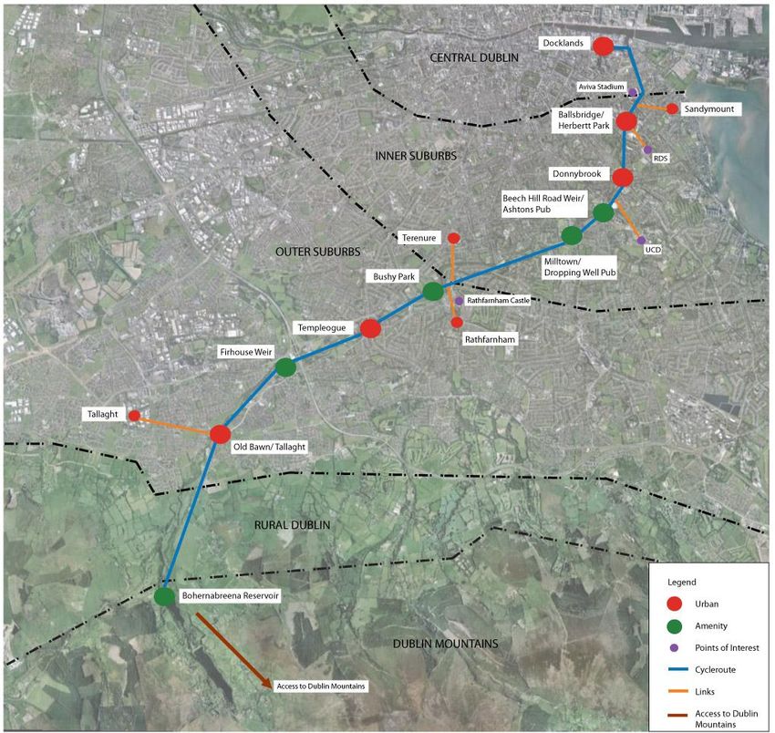
Roughan & O'Donovan - AECOM Alliance                                                                                                                River Dodder Greenway
Consulting Engineers                                                                                                                                Feasibility Study Report

                                                                                       River Dodder Greenway
                                                                                    From the Sea to the Mountains

                                                                                        Feasibility Study Report

Document No: ............. 12.176.10 FSR

Made: ........................... Eoin O Catháin (EOC)

Checked:...................... Seamus MacGearailt (SMG)

Approved: ....................

                                                         Revision                Description    Made           Checked   Approved       Date
                                                  Feasibility Study Report         DRAFT        EOC             SMG                 November 2012
                                         A (Implementation and Costs included)    DRAFT 2       EOC             SMG                 January 2013
                                                             B                     Issue 1      EOC             SMG        SMG      January 2013

Ref: 12.176.10FSR                                                                               January 2013                                                         Page i
Roughan & O'Donovan - AECOM Alliance                                                                                                                                                                                                                                                                   River Dodder Greenway
Consulting Engineers                                                                                                                                                                                                                                                                                   Feasibility Study Report

                                                                                                                                  River Dodder Greenway
                                                                                                                               From the Sea to the Mountains

                                                                                                                                      Feasibility Study Report

                                                                                                                                           TABLE OF CONTENTS

1.    Introduction ......................................................................................................................................................................................................................................................................... 1
2.    Background / Planning Context ........................................................................................................................................................................................................................................ 1
      2.1     Background ...................................................................................................................................................................................................................................................................................... 1
      2.2     Dublin City Development Plan 2011-2017......................................................................................................................................................................................................................................... 1
      2.3     Bushy Park Landscape Masterplan and Management & Development Plan ..................................................................................................................................................................................... 2
      2.4     Dublin Docklands Development Masterplan 2008 ............................................................................................................................................................................................................................. 2
      2.5     River Dodder Catchment Flood Risk Management Plan (CFRMP) ................................................................................................................................................................................................... 2
      2.6     Ringsend/Irishtown and the River Dodder Area Action Plan ............................................................................................................................................................................................................. 2
      2.7     South Dublin County Council Development Plan 2010 - 2016 .......................................................................................................................................................................................................... 2
      2.8     The Dodder Valley Linear Park Draft Plan, June 1996 ...................................................................................................................................................................................................................... 3
      2.9     Dún Laoghaire-Rathdown County Development Plan 2010-2016 ..................................................................................................................................................................................................... 3
      2.10 Cycle Network Strategy for the Greater Dublin Area ......................................................................................................................................................................................................................... 3
      2.11 Smarter Travel: A Sustainable Transport Future 2009 - 2020 ........................................................................................................................................................................................................... 3
      2.12 National Cycle Policy Framework 2009 ............................................................................................................................................................................................................................................. 3

3.    Objectives for the Route .................................................................................................................................................................................................................................................... 4
4.    General Requirements ....................................................................................................................................................................................................................................................... 5
5.    Feasibility Assessment ...................................................................................................................................................................................................................................................... 6
      5.1     Grand Canal Square to Fitzwilliam Quay (Section 1) ........................................................................................................................................................................................................................ 6
      5.2     Londonbridge Road / Bath Avenue to Ballsbridge (Section 2) .......................................................................................................................................................................................................... 9
      5.3     Ballsbridge: Beatty's Avenue to Herbert Park (Section 3) ............................................................................................................................................................................................................... 11
      5.4     Herbert Park through Donnybrook to Eglinton Road (Section 4) ..................................................................................................................................................................................................... 13
      5.5     Eglinton Road to Dundrum Road (Milltown) (Section 5) .................................................................................................................................................................................................................. 14
      5.6     Dundrum Road (Milltown) to Lower Dodder Road (Section 6) ......................................................................................................................................................................................................... 18
      5.7     Lower Dodder Road to Springfield Avenue (Section 7) ................................................................................................................................................................................................................... 22
      5.8     Springfield Avenue to M50 (Section 8) ............................................................................................................................................................................................................................................ 24
      5.9     M50 to Old Bawn Road (Section 9) ................................................................................................................................................................................................................................................. 26
      5.10 Old Bawn Road to Kiltipper Woods Cafe (Section 10) .................................................................................................................................................................................................................... 27
      5.11 Kiltipper Woods Cafe to Bohernabreena Reservoirs (Section 11) ................................................................................................................................................................................................... 28
      5.12 Bohernabreena Reservoirs (Section 12) ......................................................................................................................................................................................................................................... 29

6.    Developing the Greenway Concept ................................................................................................................................................................................................................................. 30

Ref: 12.176.10FSR                                                                                                                                      January 2013                                                                                                                                                     Page ii
Roughan & O'Donovan - AECOM Alliance                                                                                                                                                                                                                                                                     River Dodder Greenway
Consulting Engineers                                                                                                                                                                                                                                                                                     Feasibility Study Report

       6.1     Materials and Furniture ................................................................................................................................................................................................................................................................... 30
       6.2     Tourism and Amenity ...................................................................................................................................................................................................................................................................... 31
       6.3     Landscape Management and Security ............................................................................................................................................................................................................................................ 32
       6.4     Sustainability................................................................................................................................................................................................................................................................................... 33
       6.5     Site Specific Objectives .................................................................................................................................................................................................................................................................. 33

7.     Planning / Environmental ................................................................................................................................................................................................................................................. 37
       7.1     Defining the Requirement for EIA ................................................................................................................................................................................................................................................... 37
       7.2     Guidance and Methodology ............................................................................................................................................................................................................................................................ 38
       7.3     Screening Assessment on Aspects of the Environment .................................................................................................................................................................................................................. 38
       7.4     Screening Conclusion and Recommendation ................................................................................................................................................................................................................................. 39

8.     Implementation ................................................................................................................................................................................................................................................................. 40
       8.1     Do Maximum Scheme..................................................................................................................................................................................................................................................................... 40
       8.2     Do Medium Scheme ....................................................................................................................................................................................................................................................................... 40
       8.3     Do Minimum Scheme...................................................................................................................................................................................................................................................................... 41

9.     Cost .................................................................................................................................................................................................................................................................................... 42
       9.1     Do Maximum Scheme..................................................................................................................................................................................................................................................................... 42
       9.2     Do Medium Scheme ....................................................................................................................................................................................................................................................................... 42
       9.3     Do Minimum Scheme...................................................................................................................................................................................................................................................................... 42

10. Conclusion and Recommendation .................................................................................................................................................................................................................................. 43

APPENDICES
Appendix A                  Figures

Ref: 12.176.10FSR                                                                                                                                        January 2013                                                                                                                                                    Page iii
Roughan & O'Donovan - AECOM Alliance River Dodder Greenway
Consulting Engineers Route Audit Report
1. Introduction 2. Background / Planning Context
Roughan & O'Donovan and AECOM, together with Copenhagenize Consulting and Cunnane 2.1 Background
Stratton Reynolds, were commissioned in August 2012 to undertake a study into the feasibility This Feasibility Study Report has been prepared with reference to the following documents:
of developing a high quality Walking and Cycling Route along the River Dodder Corridor. The
Study is being co-ordinated by South Dublin County Council but also includes parts of the Dublin City Development Plan 2011-2017;
respective jurisdictions of Dublin City Council and Dún Laoghaire - Rathdown County Council. Bushy Park Landscape Masterplan and Management & Development Plan;
The study is being funded by the National Transport Authority. Dublin Docklands Development Masterplan 2008;
River Dodder Catchment Flood Risk Management Plan;
The Study covers the entire length of the River Dodder between the mouth at the River Liffey at
Grand Canal Dock to its source at Bohernabreena in the Dublin Mountains. The purpose of this Ringsend/Irishtown and the River Dodder Area Action Plan;
report is to document the findings of the Study and to identify (a) feasible route(s) to complete a South Dublin County Council Development Plan 2010 - 2016;
high quality amenity and commuter route between the city centre and the mountains. The Dodder Valley Linear Park Draft Plan June 1996;
This Feasibility Study Report has been prepared addressing the route in Sections, defined by Dún Laoghaire-Rathdown County Development Plan 2010-2016;
geography and / or land use character. The route starts at Grand Canal Square at the GDA Cycle Network Plan;
confluence of the Canals Premium Cycle Route and the proposed River Liffey Cycleway Smarter Travel: A Sustainable Transport Future 2009 – 2020; and
scheme and follows the course of the River Dodder in a south-westerly direction to the Dublin
Mountains at the Glenasmole Reservoirs in Bohernabreena. National Cycle Policy Framework 2009.
2.2 Dublin City Development Plan 2011-2017
2.2.1 Connecting and Sustaining the City’s Infrastructure
The vision for cycling is to make Dublin a city where people of all ages and abilities have the
confidence, incentive and facilities to cycle so that by 2017, 25-30% of all new commutes within
the city will be by bike. Infrastructure works will concentrate on improving cycle safety, access,
parking and developing and improving the Dublin Cycle Network.
It is an objective of Dublin City Council to develop new cycle links including:
Sandymount to Clontarf using Dodder Bridge and Macken Street Bridge
Figure 2.1 below illustrates the Green Cycle Corridors proposed as part of the plan, of which the
River Dodder is one.
Figure 2.1 Dublin City Green Cycle Network
Ref: 12.176.10FSR January 2013 Page 1
Roughan & O'Donovan - AECOM Alliance River Dodder Greenway
Consulting Engineers Feasibility Study Report
2.2.2 Greening the City Economic: loss or damage to buildings or infrastructure, and the disruption of activities
It is an objective of Dublin City Council to continue to develop the Dodder Linear Parks between that have economic value;
Lansdowne Road and Londonbridge, Ballsbridge and Donnybrook, and Donnybrook and Social: loss or damage to human life, health, community and social amenity; and
Milltown and also to promote and actively pursue the development of a park in the area known Environmental and Heritage: consideration of the sensitivity of the river environment,
as ‘Scully’s Field’. habitats and species, plus the cultural and historical environment, to flooding.
For the river Dodder, it is an objective of Dublin City Council to take into public ownership/ A damage assessment has been undertaken to determine the direct economic damages to
create Rights of Way along and across the Dodder at key points and to maintain existing properties and infrastructure in the Dodder catchment as a result of current levels of flood risk.
bridges for pedestrians and cycle traffic. As expected, the greatest economic property damages occur in the lower Dodder area, which
has the highest density of properties and a significant flood risk due to both fluvial and tidal
2.2.3 Strategic Cycle Network flooding. The Whitechurch Stream and Dundrum Slang are at moderate economic flood risk
Dublin City’s Strategic Cycle Network has been subdivided into an indicative list under some of and the majority of the remaining urban areas have a lower economic risk of flooding. The most
the following subdivisions: significant number of properties at social risk is again located in lower Dodder (Donnybrook
area) which is at risk from fluvial and tidal flooding.
Inner city cycle routes
Primary Priority: Essex Quay to a bridge over the Dodder mouth to York Road. The SEA process has assessed the impacts of flooding on the environment and heritage, at a
Recreational routes strategic level, in terms of the loss, damage or benefit to the environment. Where flood risks are
River Dodder significant, the study has identified a range of potential flood risk management options to
manage these risks, including structural options (e.g. flood walls and embankments) and non-
2.3 Bushy Park Landscape Masterplan and Management & Development Plan structural options (e.g. flood forecasting and development control).
The sections below outline the key interventions as described in the Plan.
2.6 Ringsend/Irishtown and the River Dodder Area Action Plan
2.3.1 New bridge & Universal Access Route The main objective of the study is to set out proposals for the improvement of the River Dodder
and its banks to provide a better amenity for the local population. The plan sets out specific
New car park proposed for southern bank of River Dodder;
policies as follows:
New bridge proposed over River Dodder into the park; and
The Authority will improve the riverside walkways along the Dodder to form a (continuous)
4m wide, wheel chair accessible, pedestrian and cycle path from the southern to northern route from the Grand Canal Basin to Herbert Park, including the provision of a cycle path.
boundary of the park.
Most of the works involved will be physical in nature and this study sets out particular proposals
2.3.2 Punctuation of Dodder Wall for the following:
Sections of the existing Dodder wall punctuated and replaced by ornamental railing to Landscaping and improvements including the provision of a cycleway to the Dodder
improve passive surveillance and biodiversity in woodland & river corridor; and Riverside.
New access gate into park at the northern end of the existing footbridge.
2.7 South Dublin County Council Development Plan 2010 - 2016
2.4 Dublin Docklands Development Masterplan 2008 In order to protect, strengthen and improve the biodiversity linkages within the County, as
The Dublin Docklands Masterplan 2008 includes strategies for the continued development of required by Article 10 of the Habitats Directive, the Council shall formulate a Green Network
the Docklands, including the Point Village and North Lotts to the north of the Liffey together with Plan or as part of the Biodiversity Plan indicating linkages between open space, sensitive
Grand Canal Harbour and the Poolbeg Peninsula on the south side. The challenge here is to habitats, river systems which shall incorporate walking routes and greenways.
knit this new distinctive character area back in to the fabric of the city through public transport
links, for example the DART Underground at Spencer Dock, new bridges and the proposed It is the policy of the Council to provide for the continued development of the Dodder
bridge at the river Dodder and by the regeneration of Pearse Street. Valley Linear Park, including:
Continued development of a walkway along the River Dodder and extension of the
2.5 River Dodder Catchment Flood Risk Management Plan (CFRMP) network of pedestrian footpaths;
The methodology adopted for the Dodder Catchment Flood Risk Assessment and Management Enhancement of the waterfall and bridge at Oldbawn;
Study (CFRAMS) has been thorough and to a level of detail appropriate for the development of Development and expansion of the Dodder Valley Linear Park in association with the
a CFRMP and associated flood mapping. It has included the collection of survey data and the development of the adjoining convent lands; and
assembly and analysis of meteorological, hydrological and tidal data. This data has been used
to develop a suite of hydraulic computer models of the River Dodder, its tributaries and Dublin Development and extension of the Dodder Valley Linear Park by securing public access
Bay. Flood maps are one of the main outputs of the study and are the way in which the model along the river bank from Oldbawn to Bohernabreena and development of lands at Tymon
results are communicated to each of the end users. The flood maps allow identification of likely South in the Dodder Valley for active and passive recreation;
locations within the Dodder Catchment at risk of flooding. The impacts of flooding have been
considered under three categories:
Ref: 12.176.10FSR January 2013 Page 2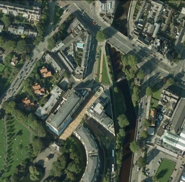
Roughan & O'Donovan - AECOM Alliance River Dodder Greenway
Consulting Engineers Feasibility Study Report
2.8 The Dodder Valley Linear Park Draft Plan, June 1996 way to get about, especially for short trips. Next to walking, cycling will be the most popular
The draft plan, covering the Dodder within the SDCC area between Oldbawn and Tallaght, means of getting to school, university, college and work. The bicycle will be the transport mode
contains a range of proposals including: of choice for all ages. We will have a healthier and happier population with consequent benefits
on the health service. We will all gain economically as cycling helps in easing congestion and
Improved access and circulation particularly along the river bank, footpaths, footbridges providing us with a fitter and more alert work force. A culture of cycling will have developed in
and trails, improved and attractive pedestrian access points, car-parking and improved Ireland to the extent that by 2020, 10% of all trips will be by bike.
access for elderly and those with impaired mobility;
Visitor Facilities, Attractions and Activities – seating and picnic areas, viewing areas, The objectives presented in this framework cover the interventions relating to our physical
facilities for nature study, interpretative material – signs and information boards; and environment that need to be made in order to encourage cycling. The objectives are presented
Community Involvement. moving, broadly, from the largest scale (urban / regional planning) to a detailed level (provision
of cycling parking etc.) and are not necessarily related to their priority. In promoting cycling, we
Section 6.3.2 of the plan recognises the potential of the park to be enjoyed by cyclists but also need to have cycling-friendly urban planning and cycling-friendly road design / traffic
proposes that cycle tracks should be in peripheral areas of the park where conflict with other management measures and integration with public transport and plentiful cycling parking and
uses/users would be avoided and that bicycles on walking routes or within conservation zones the other measures described in this document. It is a very broad package of measures that is
would be discouraged required, not just single, specific interventions.
2.9 Dún Laoghaire-Rathdown County Development Plan 2010-2016 Objective 3 is to provide designated rural signed cycle networks providing especially for visitors
and recreational cycling. The network identified will mainly use a mix of minor roads, and some
2.9.1 Open Space and Recreation greenways. The greenways are especially important for, typically, the first 10km along the
It is the vision of Dun Laoghaire Rathdown County Council to protect and enhance the routes emanating from busy town centres which are heavily trafficked and particularly
established network of open spaces in Dún Laoghaire-Rathdown and to ensure that a range of unattractive for inexperienced or very young cyclists. While the overall framework of the tourism
high quality, relevant and easily accessible recreational and leisure facilities and public spaces network has been identified, there is more work to be carried out to identify further routes,
are readily available to meet the needs of all residents of, and visitors to, the County. The particularly in the Midlands and particularly to use existing traffic free routes such as the canal
Council will encourage the linkage of parks and greenways throughout the County. and river tow paths. There is also further work to be carried out in identifying which sections of
the extensive network of disused rail-lines would be most suitable to be converted to high
It is Council policy to develop a comprehensive network of County greenways linking parks and quality, traffic-free routes suitable for cyclists of all ages and abilities.
public open spaces and to work with adjoining local authorities and other stakeholders to
achieve and improve external linkages.
The Dodder River Valley has been identified as a greenway route.
2.10 Cycle Network Strategy for the Greater Dublin Area
AECOM and ROD are separately preparing a Cycle Network Strategy for the Greater Dublin
Area. The emerging strategy has identified the River Dodder corridor as a key commuting and
amenity route. As it is likely to be one of the first routes to be delivered, it should be a showcase
route to set a standard for others to achieve as the wider network is developed over the coming
decade.
2.11 Smarter Travel: A Sustainable Transport Future 2009 - 2020
This policy document sets its key targets as:
Nationally, 500,000 more people will take alternative means to commute to work to the
extent that the total share of car commuting will drop from 65% to 45%;
Alternatives such as walking, cycling and public transport will be supported and provided
to the extent that these will rise to 55% of total commuter journeys to work; and
A reduction will be achieved on the 2005 figure for greenhouse gas emissions from the
transport sector.
2.12 National Cycle Policy Framework 2009
The Government is committed to developing cycling as one of the most desirable modes of
travel, it being good for your health, the economy and the environment. This National Cycle
Policy Framework (NCPF) sets out objectives to the year 2020 to achieve its vision. The vision
is that all cities, towns, villages and rural areas will be bicycle friendly. Cycling will be a normal
Ref: 12.176.10FSR January 2013 Page 3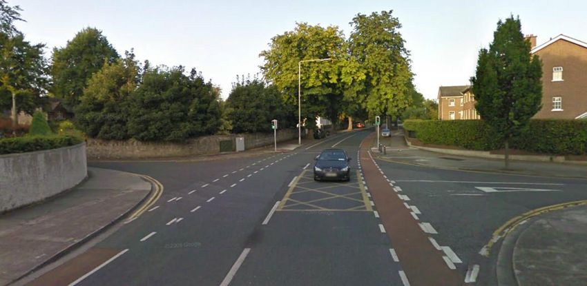
Roughan & O'Donovan - AECOM Alliance                                                                                                                                                                    River Dodder Greenway
Consulting Engineers                                                                                                                                                                                         Route Audit Report

3.      Objectives for the Route                                                                                               Greenways promote non-motorized forms of transport and mass transit, encourage
                                                                                                                               mobility and tourism related to walking, cycling, horse-riding, boating etc. Greenways
        The function of the route will be manifold. The following is a non-exhaustive list of objectives for                   contribute to increasing road safety and sustainable transport in urban and rural areas for
        the route taken into account by the consultancy team in undertaking the study:                                         many different user groups, including disabled, elderly and children.
        (i)   To cater for commuting - the route will have to be sufficiently attractive to compete time-
              wise with the alternative on-road routes along the N81 and R114 into Dublin City from the                   2.   Promoting healthy lifestyles
              greater Tallaght area.                                                                                           Greenways contribute to promoting healthy life-styles and improving the quality of life of
        (ii)  To cater for tourist amenity - it is envisaged that the route will attract cycle tourists                        local residents and visitors by encouraging active tourism, recreation and sports in the
              undertaking circuits through the Dublin and Wicklow Mountains.                                                   open air and in natural environments.
        (iii) To cater for local amenity - the route should benefit local communities through enhancing                   3.   Development of eco-tourism and natural and cultural heritage conservation
              existing amenity paths and providing new linkages to adjacent communities and village
                                                                                                                               Greenways contribute to the development of different types of environmentally-friendly
              centres.
                                                                                                                               tourism, including creation and promotion of environmental tourist products. All tourist
        (iv) To connect areas of parkland - the route should provide clear and coherent connectivity                           products promoted along Greenways share the common principle of using local potential
              between existing parks along the river corridor - such as Bushy Park and Herbert Park.                           and supporting local communities – they are created with local resources: tourist services,
        (v)   To enhance the ecological corridor - the scheme should have a neutral to positive impact                         cultural opportunities, local products and point of sale, as well as other community
              on local ecology. This can be achieved by inclusion of complementary planting and                                initiatives. Greenways serve to support grassroots and regional initiatives aimed at
              features for flora and fauna.                                                                                    cultural, natural and landscape heritage conservation.
        (vi) To benefit local business - the scheme will increase accessibility to local businesses and
              village centres along the river corridor.                                                                   4.   Supporting economic and social development of communities, including enterprise
        (vii) To be a Greenway of international renown - the scheme must avoid compromises and be                              development
              on a par with the best greenways in the world.                                                                   Greenways contribute to the development of local economies and encourage enterprise
                                                                                                                               among local populations. Establishment of Greenways serves to initiate development of
        European Greenways definition                                                                                          accommodation, food and guiding services. Trails promote establishment of galleries and
        “Greenways are communication routes reserved exclusively for non-motorised journeys,                                   points of sale for local products, tourism information services, sport and tourism
        developed in an integrated manner which enhances both the environment and quality of life of                           equipment hire services etc.”
        the surrounding area. These routes should meet satisfactory standards of width, gradient and
        surface condition to ensure that they are both user-friendly and low-risk for users of all abilities.             This study addresses the feasibility of creating a Greenway in terms of its route alignment and
        (Lille Declaration, European Greenways Association, 12th September 2000).”                                        deliverability, however such a route is a resource or means to developing the Greenway
                                                                                                                          concept which will be an ongoing process throughout the lifetime of the route. These concepts
                                                                                                                          are further explored in Section 6.

        In common with the project objectives above The European Greenways Association (EGA)
        describes the Functions of Greenways:

        “In principle, Greenways - natural and cultural heritage trails have four basic functions:

        1.     Sustainable transport and safety

Ref: 12.176.10FSR                                                                                          January 2013                                                                                                 Page 4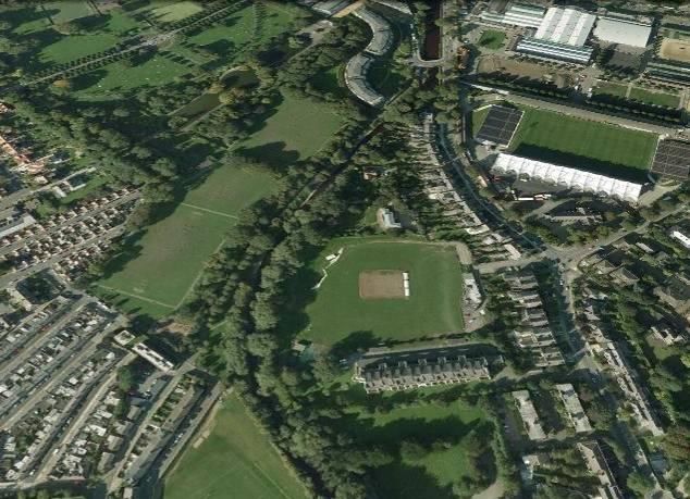
Roughan & O'Donovan - AECOM Alliance River Dodder Greenway
Consulting Engineers Route Audit Report
4. General Requirements CCTV
Certain sections of the route will may CCTV coverage for security reasons where it is
The following requirements have been identified for the Greenway Route in order to achieve the remote from the main road corridors that provide passive surveillance. It will likely be
objectives set out above: impractical to monitor the entire length of the route. The preliminary design should
consider locations where CCTV is most necessary.
Coherence and Directness
The route will have to be legible and coherent and easy for tourists and locals to follow. Environment
Even independent of any signage proposed, it should be possible to logically follow the The River Dodder provides an important ecological corridor through the length of the
route along the river. scheme from the Dublin Mountains to the River Liffey. The site links a number of parks
from Glenasmole, Kiltipper Park, the Dodder Valley Park, Bushy Park, Orwell Park, Dartry
Width Park and Herbert Park, allowing for the connection of existing nature areas and maintains
One of the principal considerations to be determined early on is the required width for the a healthy ecosystem. The linking of nature areas allows for species to move, migrate,
route. The National Cycle Manual suggests a minimum width of 2.5m for two cyclists disperse and exchange populations between these areas in order to secure their long
cycling abreast with another overtaking. Given the need to also accommodate pedestrians term survival. The site is an important habitat for a range of species including otter,
on the route, a general width requirement of 4m is proposed. This will cater for two-way kingfisher, badger and bats along with a numerous avian fauna. Habitats include wet
cycling and pedestrian activity. Where particular pinchpoints exist, an absolute minimum grassland riparian woodlands, dry and calcareous meadows and tufa forming calcareous
width of 3.0m should be provided to allow two cyclists to pass or one cyclist to pass a springs. The river support an excellent supply of fish and salmon are present in its lower
pedestrian. reaches. Invasive species, in particular Himalayan Balsam and Japanese knotweed are
found throughout the river corridor.
Priority
In parallel with the scheme there is opportunity to include features to enhance the existing
Where at-grade public road crossings are required, and compromises in terms of traffic
ecological corridor.. Such features might include:
capacity are necessary, these should generally favour the greenway route. Advance
sensors, be they radar or detection loops should be included on the greenway on - Assessment of the weirs along the route for potential provision of salmon passage.
approach to the road crossings so as to enable the cycle signals to switch to green - Artificial otter holts.
promptly and minimise delay and disruption for cyclists. These might include intelligent - Dipper and Bat boxes.
sensors that would apportion priority based on the number of cyclists approaching, or
- Vortex weirs for outfalls to improve water quality
which might give greater priority to the greenway in inclement weather conditions.
- Landscaping consideration for the enhancement of the aquatic environment
All road crossings should be toucan crossings, a minimum of 4m wide, and with push
button units on each side of the Greenway. Raised bars for cyclists to rest their foot on Maintenance
when stopped should also be provided on each side. Where the route is shared with traffic The scheme should require minimal maintenance to reduce the whole life cost. This
and crosses as busy road, the junction layout should generally be tightened to provide an should be considered in the design of any complementary planting along the route and in
increased area for pedestrians and cyclists. the design of bridges and other structures (which should all be fully integral).
Access and Permeability
Lighting All kissing gates along the route should be removed. These are an intolerable barrier to
High quality public lighting should be installed along the route (where not already present) cycling and other means of controlling anti-social behaviour should be identified, including
along the entire length of the scheme from the River Liffey to the gates of the CCTV. A bollard or two at the entry to a 4m wide track would prevent vehicular access but
Bohernabreena Reservoirs complex. While the route's commuter function will be minor can accommodate cyclists. Occasional abuse of the greenway by motorbikes may be a
west of Old Bawn Road, the continuation south-westward will be largely off-road and problem but the solution to this should not be to render the proposed cycleway unusable
lighting will reduce the risk of anti-social behaviour. Uplighters rather than conventional by the vast majority of responsible pedal cyclists.
lamp post lighting might be considered at the extreme eastern end of the route.
Links to the surrounding areas should be provided all along the route to maximise the
Paving usage of the greenway.
The route should provide a high quality and smooth riding surface, generally free from
service chamber covers, bumps around tree roots, etc. Newer sections should be Tourism
surfaced with fine cold asphalt or equivalent. There may be merit in the provision of a high The greenway should emphasise features of interest to tourists along the route. Signage
quality aesthetic finish atop the asphalt along certain sections, similar to the surface boards and sheltered stops should be included in the design. Local businesses should be
treatment on the Grand Canal Route between Blackhorse and Adamstown. Such encouraged to engage with the scheme, which could deliver additional custom to their
materials are costly and it would likely be unjustified to provide such surfacing premises.
continuously along the route.
Ref: 12.176.10FSR January 2013 Page 5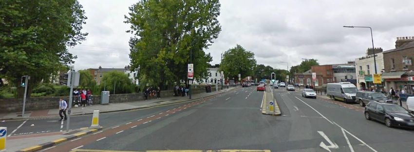
Roughan & O'Donovan - AECOM Alliance River Dodder Greenway
Consulting Engineers Feasibility Study Report
Signage 5. Feasibility Assessment
In addition to the signboards proposed for tourists, a comprehensive and coherent route
signage strategy should be developed for the greenway. This should include The following assessment is illustrated on the accompanying drawings, grouped by Section in
complementary signage towards the route from its hinterland and from the greenway each case.
towards village centres and other features of interest.
5.1 Grand Canal Square to Fitzwilliam Quay (Section 1)
Flooding The route will start from the Grand Canal Premium Cycle Route at Grand Canal Square at the
The preliminary design should take account of the Dodder Flood Defence Scheme, which junction of Forbes Street and Misery Hill / Hanover Quay, about 500m west of the confluence of
is constructed or under construction from the Liffey as far as Ballsbridge. Further such the River Dodder and the River Liffey. The most logical route to the Dodder is along Hanover
flood works are likely to be required farther west along the river and these should be Quay to the Grand Canal Dock lock gates. A new crossing of the locks will be required to
designed in a manner sympathetic to the greenway. Indeed, there may be considerable connect the route to the River Dodder at South Dock Road.
scope for synergy between the proposed greenway scheme and the required flood
defence works. In the longer term, an alternative route may be provided following the construction of the Dodder
Public Transport Bridge connecting the eastern end of Sir John Rogerson's Quay to Ringsend
Mitigatory planting and on to the Poolbeg peninsula. This should provide a direct connection from the River Liffey
Where trees are required to be removed to facilitate the development of the greenway Cycleway scheme to the River Dodder Greenway on the eastern side of the river.
route, compensatory planting should be provided nearby. Where possible, existing
greenery along the river corridor should be maintained. At the plaza in front of the Grand Canal Theatre, the layout of the planters is incompatible with
the provision of a high priority through route for cyclists. This issue was not addressed in the
Dog walkers design of the Cross-City Canals Premium Cycle Route but should be revisited when the Dodder
Route is developed, given the importance of the plaza as a principal intersection in Dublin City's
During the various route audit for the scheme, significant numbers of dog walkers were emerging cycle network.
observed along the river corridor, particularly in the parks along the route. It is likely that
the development and promotion of the greenway as a cycleway will alert dog walkers of (1) Hanover Quay
the presence of cyclists. However, additional signage warning dog walkers to be
conscious of leashes crossing the path of oncoming cyclists should be considered. There are buildings along the eastern section of the quay frontage blocking a route along
the Campshire. Hanover Quay is a quiet road suitable for on-road cycling in a shared
Synergy with utility proposals environment. A cycle track exists along the western section of the campshire, but it is too
narrow for two-way cycling and walking and would require to be widened within the
The opportunities for synergies between the proposed Greenway Route along the River cobbled surface. Otherwise the route should remain on road until 30m - 50m before the
Dodder and proposals for new or upgraded services / utilities should be investigated. Dock Gates, before joining the Campshire. The principal interventions required along this
While it might provide an additional funding avenue, any appreciable volume of excavation section of the scheme are:
would increase the environmental impact of the scheme and the implications would
required detailed consideration. Road resurfacing and possible drainage enhancements to provide a smooth cycling
surface;
Green Energy Route signage;
The public lighting along the route will require power supply. Consideration should also be Repaving of the eastern section of the campshire to provide a 4m wide areas for
given to the inclusion of small hydro power turbines that could power the public lighting. pedestrians and cyclists with a suitable transition to the shared road area.
Diversions during construction
The design of the route should have regard to the need to maintain access to parks and
the river corridor during the construction period, insofar as is practicable.
Some of these issues are elaborated on further in Section 6 “Developing the Greenway”.
Hanover Quay Campshire
In conjunction with the above, it is recommended that Dublin City Council investigate the
scope for renovating the delapidated buildings along the campshire to provide passive
surveilance of the route and to continue the regeneration of the docklands area. A
Ref: 12.176.10FSR January 2013 Page 6Roughan & O'Donovan - AECOM Alliance River Dodder Greenway
Consulting Engineers Feasibility Study Report
Strategic Development Zone is currently being prepared for the South Docks area and this (3) South Dock Road
should have regard to the aspirations for the Dodder Greenway. The area around the western landing at the Canal Lock is run down, with hoarding / high
walls on either side of the route. Presumably, this will be redeveloped at some point.
If the demolition of the delapidated buildings on the campshire is considered, it would be There is an opportunity as part of the South Docks SDZ to develop the former graving
preferable to provide a 4m wide zone for pedestrians and cyclists along the full length of docks behind the wall into a heritage feature. Should such a heritage feature be
the campshire. This could be delivered as a future enhancement to the Greenway Route. developed, the heritage feature should logically include historical information on the River
Dodder, including the development of the Bohernabreena Reservoirs and water supply
(2) Grand Canal Dock Locks infrastructure that can be visited further upstream. Features of ecological interest should
The first significant obstacle to the route is the crossing of the Canal Dock Gates. There also be described. This would provide information to tourists setting off from the city on
are three separate locks (from west to east: Westmoreland Lock, Buckingham Lock and the importance of the river to the city.
Camden Lock) with landing areas in between. At present, it is possible to walk across the
lock gates of Westmoreland and Buckingham Locks and a fixed bridge exists across the There is a wide route through to South Dock Road, and along the west bank of the River
larger Camden Lock. Dodder to Ringsend Road Bridge. The surface is poor and would require treatment to
cater for cycling along the route.
Canal Locks Fixed Bridge (background)
Route from Lock South Dock Road
There is a range of options available to overcoming the obstacle posed by the Canal Lock.
Options for consideration might include: (4) Ringsend Road Bridge Crossing
Development obstructs a route along the western side of the Dodder south of the
Landmark fixed structure spanning over the three locks; Ringsend Road crossing. Furthermore, the recent flood defence works immediately abut
The bridges along the Grand Canal have a general clearance of 2.75m (9 feet), the river and any new route on the western side would require significant modifications to
however the railway bridge just upstream of Grand Canal Basin has a restriction of these Works. Fitzwilliam Quay on the eastern side is suitable for a cycling route. The
2.45m. No such clearance restriction exists downstream of the Ringsend Road route will have to cross the Dodder in the vicinity of Ringsend Road, either upstream or
Bridge. The Basin is regularly used by yachts and, on that basis, it would appear to downstream of the Ringsend Road bridge (Ringsend Road bridge is too narrow to
be impractical to impose a similar height restriction over the Canal Locks. accommodate two traffic lanes and the proposed Greenway Route. The footpaths on
Consultation would be required with the City Council, the Dublin Docklands Ringsend Road Bridge are much too narrow and there is a separate need to provide
Development Authority and Waterways Ireland if this option is to be further explored. improvements for pedestrians and cyclists along the route from Ringsend to the city
Three opening bridges or a combination of fixed and opening bridges across the centre).
three locks. For example, (an) opening bridge(s) might be considered across
Westmoreland and Buckingham Locks together with replacement or augmentation The greenway route will also have to cross Ringsend Road from north to south. At
of the existing fixed bridge over Camden Lock to provide an overall wdith of at least present, there are steps from South Dock Road up to Ringsend Road, forming an
4m to accommodate cyclists along with pedestrians. Alternatively, the widths of obstacle to cyclists and the mobility impaired. There is no scope for the route to pass
Buckingham and Camden Locks (and the island in between) suit a two span bridge under Ringsend Road so the route design will require measures to overcome this level
with a pivot on the island that would allow manual operation of a 3m wide structure difference. [There is an alternative route following South Dock Road around to the west
and would reduce running costs. This would be complemented by a fixed bridge onto Ringsend Road at the South Lotts Road junction - but this is too circuitous to be
across Westmoreland Lock. attractive.]
If the latter option (which is the more likely) proceeds, the two / three short bridges should, Ringsend Road bridge is an attractive masonry structure and any new bridge adjacent
if possible, be constructed on a straight line alignment or as near as possible. The would require high quality architectural design to complement the existing views of the
practicality of this will be dictated by the opening mechanism for the opening bridges, bridge.
which would best rotate horizontally rather than by lifting as this would involve less
disruption to the structure of the lock walls.
Ref: 12.176.10FSR January 2013 Page 7Roughan & O'Donovan - AECOM Alliance River Dodder Greenway
Consulting Engineers Feasibility Study Report
feasible, consideration could be given to making Fitzwilliam Quay one-way with return
access to / from Irishtown Road via Dermot O Hurley Avenue.
Ringsend Road Bridge Steps to Ringsend Road
Possible design solutions might include:
Bridge crossing north of the Ringsend Road bridge into the grounds of St. Patrick's Fitzwilliam Quay (view south) Fitzwilliam Quay (view north)
Church with ramped approach on South Dock Road; Toucan crossing across
Ringsend Road on the eastern side of the road bridge; The southern part of Fitzwilliam Quay comprises a footpath and linear park. There is
scope to provide a two-way cycle track through the linear park alongside the footpath. The
Toucan crossing across Ringsend Road on the western side of the road bridge and
route is obstructed by an old pump-house and the best solution would be to leave the
bridge crossing immediately upstream of Ringsend Road bridge on the southern
footpath pass on the narrow western side of the building and to take the cycle track
side.
around the other side.
Either option is feasible but the upstream option might be somewhat less intrusive.
Nevertheless, independent of the River Dodder Greenway Route, there is a need to
improve facilities for pedestrians across Ringsend Bridge. This is part of the most direct
route for pedestrians from the city centre to the amenity areas of Poolbeg and
Sandymount Strand and the current facilities provided are substandard. It may therefore
be the case that new structures are required on both sides of the bridge - the bridge on
the downstream side could perhaps be provided for pedestrian use only and the bridge on
the upstream side shared as part of the greenway.
Linear Park on Fitzwilliam Quay Pumphouse
(6) Interface with Sutton to Sandycove Route
It is recommended that consideration be given to running the Sutton to Sandycove Route
along the River Dodder Walking and Cycling Route from Grand Canal Square to
Fitzwilliam Quay - at least in advance of the completion of the River Dodder Public
Transport Bridge across the mouth of the river at Sir John Rogerson's Quay. A possible
route along Dermot O'Hurley Avenue and St. Brendan's Terrace into Ringsend Park has
Ringsend Road Bridge Upstream side of Bridge been identified that could link onward to Strand Road. This has been postulated in a
separate report by Roughan & O'Donovan and is beyond the scope of this study.
It is recommended that the design is progressed on the basis of a 4m wide new light
independent bridge crossing on either side of Ringsend Road Bridge. (The bridge on the
north side could be constructed as 2m wide between parapets if cyclists are not to be
accommodated).
(5) Fitzwilliam Quay
There is a wide road carriageway with parking on either side along Fitzwilliam Quay.
There is also a wide footpath on the river side. The road space would need to be
reapportioned to gain additional space for a two way cycle track along the northern
section. This will require adjustment to the current parking facilities. Should this not prove
Ref: 12.176.10FSR January 2013 Page 8Roughan & O'Donovan - AECOM Alliance River Dodder Greenway
Consulting Engineers Route Audit Report
5.2 Londonbridge Road / Bath Avenue to Ballsbridge (Section 2)
(1) London Bridge to Lansdowne Road
Between Londonbridge Road / Bath Avenue and Lansdowne Road, there are pedestrian
routes available on both sides of the river. The route on the eastern side was recently
upgraded as part of the River Dodder Flood Defence Scheme. However, this route is quite
narrow with a width of approximately 2.0m along the edge of Lansdowne Tennis Club.
There are also pedestrian barriers along this section of the route which obstruct access
for cyclists. There are occasional galleries along this section which permit passing - but
overall it is considered unsuitable for the proposed River Dodder Walking and Cycling
Route due to the narrowness.
It is desirable for the greenway to remain on the eastern (left) bank of the river along this London Bridge
section so as to avoid the need to cross the river twice at Bath Avenue and Lansdowne
Road. It will be necessary therefore to widen the existing walkway to 4m to accommodate Alternatively, a boardwalk / independent structure could be constructed upstream or
cyclists and pedestrians. The feasibility of widening the path into the river by the provision downstream of the existing bridge. A toucan crossing would be required across Bath
of a 2m cantilever should be explored at preliminary design stage. The principal concern Avenue - and the shuttle signals amended to ensure priority lies with the Greenway route.
with such a proposal is likely to be flooding considerations. However, given the width of
the river at this point, and assuming a similar open parapet to the existing walkway, the London Bridge Road to Lansdowne Road
impact of a cantilever structure on the carrying capacity of the river is likely to be almost The path between Bath Avenue and the Aviva Stadium on the western side of the river is
negligible. of good quality construction (fine cold rolled asphalt) and is in excess of 5m wide - it is
used as a main access to the stadium on match days. However, it narrows down to 1.8m -
2m past the stadium and this would need to be widened to 4m minimum to accommodate
the proposed high quality greenway for which there is space available within the grass
verges. There are no particular environmental sensitivities along this section that would
prevent this.
Route along Eastern Side of River
In the event that widening the path on the eastern side of the river is found to be infeasible
or impracticable, the route could alternatively cross the river at Londonbridge Road / Bath
Avenue and cross back at Lansdowne Road. This would however lead to a requirement
for four sharp cornering manoeuvres for cyclists, reducing the attractiveness of the route Walkway from Bath Avenue to Stadium Route past Stadium
and likely leading to many cyclists attempting to force their way up the narrow path on the
eastern side of the river. Lansdowne Road Bridge
There are residential properties between Lansdowne Road and Shelbourne Road and the
Notwithstanding the above concerns, the issues facing the alternative route are explored left bank of the river upstream as far as Ballsbridge. There is no scope to continue a route
below. along that side of the river without land acquisition. As such, the alternative route would
have to cross back across the Dodder at Lansdowne Road Bridge. This bridge currently
London Bridge carries two traffic lanes with narrow footpaths. The options for the treatment of the
London Bridge currently operates on a shuttle basis, with one lane alternatively catering crossing are similar to those at London Bridge:
for eastbound and westbound traffic movements. The shuttle runs along the middle of the Implement shuttle system for traffic on the bridge and run the Dodder Walking and
bridge. It may be possible to amend the cross section of the bridge to move the traffic Cycling Route down one side;
lane to one side. This would create space for a two-way cycle route or at least a 3m wide
shared area on the other side. This would be the absolute minimum provision required to Construct a boardwalk / independent structure upstream or downstream of the
accommodate a route capable of achieving the objectives of a high quality greenway. bridge.
Ref: 12.176.10FSR January 2013 Page 9You can also read