AMISK HYDROELECTRIC PROJECT - PROJECT DESCRIPTION Submitted to: Canadian Environmental Assessment Agency (CEAA)
←
→
Page content transcription
If your browser does not render page correctly, please read the page content below
PROJECT DESCRIPTION

AMISK HYDROELECTRIC PROJECT

                                       Submitted to:

     Canadian Environmental Assessment Agency (CEAA)

                                       October 2015
Amisk Hydroelectric Project                                      Description of a Designated Project                                         October 2015

Table of Contents
1.     General Information and Contacts ....................................................................................................... 1
     1.1   Nature of Project........................................................................................................................... 1
     1.2   Proponent’s Information .............................................................................................................. 1
     1.3   Consultation Undertaken .............................................................................................................. 2
     1.4   Regulatory Requirements of Other Jurisdictions .......................................................................... 4
     1.5   Environmental Studies Conducted in Project Area ....................................................................... 4
2.     Project Information ............................................................................................................................... 5
     2.1    General Description, Context and Objectives ............................................................................... 5
                 Project Context and Objectives............................................................................................. 5
                 General Description of Project Components ........................................................................ 6
     2.2    Project Activities ......................................................................................................................... 17
                 Construction........................................................................................................................ 17
                 Operation ............................................................................................................................ 19
                 Decommissioning ................................................................................................................ 19
     2.3    Emissions, Discharges and Waste ............................................................................................... 20
                 Atmospheric Emissions ....................................................................................................... 20
                 Liquid Discharges ................................................................................................................ 20
                 Waste Disposal .................................................................................................................... 21
3.     Project Location .................................................................................................................................. 22
     3.1    Description of Project Location and Site Plan ............................................................................. 22
                 Project Coordinates............................................................................................................. 22
                 Site Plan............................................................................................................................... 22
                 Project Maps ....................................................................................................................... 22
                 Photographs ........................................................................................................................ 28
                 Proximity of the Project ...................................................................................................... 28
     3.2    Land and Water Use.................................................................................................................... 28
                 Zoning Designations ............................................................................................................ 28
                 Legal Land Descriptions....................................................................................................... 29
                 Surface Description ............................................................................................................. 29
                    Private Surface ................................................................................................................ 30
                           Alberta Crown Surface .................................................................................................... 30
                       Subsurface Description ....................................................................................................... 31
                         Private Subsurface .......................................................................................................... 31
                           Alberta Crown Subsurface .............................................................................................. 31
                           Lessees ............................................................................................................................ 32
                       Water Use ........................................................................................................................... 32
                       Relevant Planning Documents used for Consultation Purposes......................................... 32
                       Use of Traditional Lands for Project Development ............................................................. 32
4.     Federal Involvement ........................................................................................................................... 33
     4.1   Federal Financial Support ........................................................................................................... 33

 AHP Development Corporation                                                                                                                            Page i
Amisk Hydroelectric Project                                     Description of a Designated Project                                         October 2015

     4.2        Use of Federal Lands for Project ................................................................................................. 33
     4.3        Federal Regulatory Requirements .............................................................................................. 33
5.     Environmental Effects ......................................................................................................................... 34
     5.1    Physical and Biological Setting .................................................................................................... 34
                 Air Quality, Noise and Climate ............................................................................................ 34
                 Geology, Terrain and Soils .................................................................................................. 38
                 Vegetation ........................................................................................................................... 39
                 Water .................................................................................................................................. 40
                 Water and Sediment Quality............................................................................................... 46
                 Wildlife ................................................................................................................................ 48
                 Aquatic Resources ............................................................................................................... 49
     5.2    Changes to Fish, Fish Habitat and Wildlife.................................................................................. 59
                 Fish and Fish Habitat ........................................................................................................... 59
                 Migratory Birds ................................................................................................................... 59
                 Changes to Environment on Federal Lands in another Province ........................................ 60
     5.3    Effects on Aboriginal Peoples ..................................................................................................... 60
                 Effects on Health ................................................................................................................. 60
                 Effects on Socio-economic Conditions ................................................................................ 60
                 Effects on Physical and Cultural Heritage Effects ............................................................... 60
                 Effects on the Current Use of Lands and Resources for Traditional Purposes ................... 61
                 Historical Resources ............................................................................................................ 61
6.     Proponent Engagement and Consultation with Aboriginal Groups ................................................... 62
     6.1   Aboriginal groups that may be interested in, or potentially affected by, the Project................ 62
     6.2   Engagement or consultation activities carried out to date with Aboriginal groups. .................. 63
     6.3   Key Comments and Concerns from Aboriginal Groups .............................................................. 64
     6.4   Consultation Plan ........................................................................................................................ 65
     6.5   Treaty Rights ............................................................................................................................... 66
     6.6   Overlap of Project Area with Traditional Land Use under Treaty Rights .................................... 66
7.     Consultation with The Public and Other Parties (other than Aboriginal consultation included above)
       67
     7.1   Key Comments and Concerns from Stakeholders....................................................................... 67
     7.2   Ongoing or Proposed Consultation ............................................................................................. 70
     7.3   Consultation with Other Jurisdictions......................................................................................... 71
8.      References .......................................................................................................................................... 72
Appendix A             : Photograph of Proposed Location of Headworks ............................................................. 76

 AHP Development Corporation                                                                                                                          Page ii
Amisk Hydroelectric Project                                      Description of a Designated Project                                           October 2015

                                                                      List of Tables
Table 1-1: Proponent Information ................................................................................................................ 2
Table 2-1: Summary of widths and depths in Amisk headpond reach of the Peace River ......................... 11
Table 3-1: Lands within one kilometre study area (full sections included) ................................................ 29
Table 3-2: Inundation impact on private lands ........................................................................................... 30
Table 3-3: Private Lands Subsurface Ownership......................................................................................... 31
Table 3-4: Alberta Crown Subsurface Ownership ....................................................................................... 31
Table 4-1: Preliminary Federal Regulatory Requirements .......................................................................... 33
Table 5-1: Summary of active WSC flow monitoring stations on the Peace River ..................................... 42
Table 5-2: Peace River monthly water temperatures recorded in the Peace River Project area (from
Mainstream 2006a)..................................................................................................................................... 47
Table 5-3: Seasonal range in suspended sediment concentration in the Peace River Project area (from
Glacier 2006) ............................................................................................................................................... 48
Table 5-4: Fish species present in the Peace River in the vicinity of the proposed Project and their provincial
status........................................................................................................................................................... 54
Table 5-5: Predicted movement patterns of the selected fish species and life stages in the Project area
(from Glacier 2006) ..................................................................................................................................... 56
Table 5-6: Distribution of habitats for selected fish species in the Peace River between Vermilion Chutes
and Peace Canyon Dam (from Glacier Power 2006)................................................................................... 58
Table 6-1: Aboriginal groups that may be interested in; or potentially affected by the Project ............... 62
Table 6-2: Previous and Proposed Aboriginal Engagement or Consultation Activities Schedule............... 65
Table 7-1: Key Comments and Concerns from Stakeholders...................................................................... 67

                                                                     List of Figures
Figure 2-1: Project Conceptual Layout ......................................................................................................... 8
Figure 2-2: Approximate Headpond Extent ................................................................................................ 10
Figure 2-3: Results of Bathymetric Survey .................................................................................................. 12
Figure 2-4: Proposed Conceptual Alternate 240kv Transmission Line Alignments .................................... 14
Figure 2-5: Access Road Corridors .............................................................................................................. 16
Figure 3-1: Project Overview ...................................................................................................................... 23
Figure 3-2: Existing Land Use ...................................................................................................................... 24
Figure 3-3: Environmentally Sensitive Areas .............................................................................................. 25
Figure 3-4: Existing Infrastructure .............................................................................................................. 26
Figure 5-1: Climate Normals from Eureka River ......................................................................................... 36
Figure 5-2: Climate Normals from Grande Prairie A ................................................................................... 37
Figure 5-3: Plan and longitudinal profile of the Peace River downstream of the W.A.C Bennett Dam ..... 44
Figure 5-4: Aquatic Baseline Studies Project area, 2015. ........................................................................... 51

 AHP Development Corporation                                                                                                                            Page iii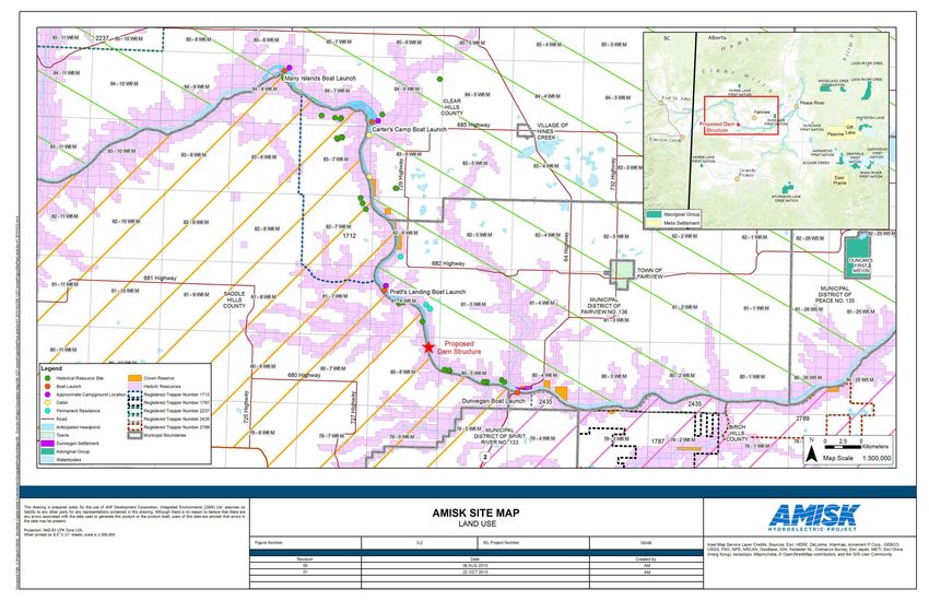
Amisk Hydroelectric Project                Description of a Designated Project   October 2015

ABBREVIATIONS AND ACRONYMS

ACO                  Aboriginal Consultation Office
ACP                  Aboriginal Consultation Plan
AEP                  Alberta Environment and Parks
AHP                  AHP Development Corporation
AIES                 Alberta Interconnected Electric System
AUC                  Alberta Utilities Commission
CASA                 Clean Air Strategic Alliance
CEAA 2012            Canadian Environmental Assessment Act 2012
CRISSP               Comprehensive River Ice Simulation System Project
EIA                  Environmental Impact Assessment
EPEA                 Environmental Protection and Enhancement Act
ESRD                 Alberta Environment and Sustainable Resource Development
FSL                  Full Supply Level
HRIA                 Historical Resources Impact Assessment
HRV                  Historical Resource Value
LSA                  Local study area
NPA                  Navigation Protection Act
NRCB                 Natural Resources Conservation Board
NTS                  National Topographic System
PAD                  Peace-Athabasca Delta
PAZA                 Peace Airshed Zone Association
RCC                  Roller Compacted Concrete
RoC                  Record of Consultation
WSC                  Water Survey of Canada

UNITS
cm                   centimetre(s)
GWh                  gigawatt hour
ha                   hectare(s)
Km                   kilometre(s)
km2                  square kilometre(s)
M                    metre(s)
m3/s                 cubic metre(s) per second
masl                 metres above sea level
mg/kg                milligram per kilogram
mg/L                 milligram per litre
MW                   megawatt
ng/L                 nanogram per litre

AHP Development Corporation                                                           Page iv
Amisk Hydroelectric Project              Description of a Designated Project               October 2015

GLOSSARY OF TERMS

Boat Locks - a device for raising and lowering boats between stretches of water of different levels e.g.
on a river that has a dam.

Cofferdam – a temporary watertight enclosure from which water is pumped to expose the bottom of a
body of water and permit construction (as of a dam).

Fishway – a device, structure, or operating system that facilitates and provides for efficient fish
passage upstream or downstream of any obstruction impeding the free passage of fish.

Gravity Dam – a concrete dam structure bound to the side of a slope where gravity holds it down
preventing water in the headpond from pushing it over.

Head – the elevation difference between the headpond and the receiving water body immediately
downstream of the hydroelectric facility.

Headworks – the physical works of the Project in the river including the dam structure, powerhouse
and spillway.

Headpond – a slower and deeper section of water situated upstream, and created by the presence, of
the hydroelectric facility.

Hydroelectric Power – electricity produced from the energy found in falling or fast-flowing water.

Impoundment – a body of water created or stored by impoundment structures such as dams, dikes, and
levees.

Order in Council – Orders in Council are the instrument by which the Lieutenant Governor in Council
makes its orders. These orders may or may not be a Regulation, as defined in the Regulations Act.

Powerhouse – the structures, machinery, and associated equipment needed for generating electric
energy from a hydroelectric dam.

Run-of-River – a term used to describe hydroelectric facilities that do not have significantlong-term
storage (i.e. less than 48 hour retention time in the headpond).

Sedimentation – occurs when particles in water settle and come to rest against a barrier.

Substation Infrastructure – a set of equipment which reduces the high voltage of electrical power
transmission to that suitable for supply to consumers.

 AHP Development Corporation                                                                        Page v
Amisk Hydroelectric Project                 Description of a Designated Project               October 2015

1. GENERAL INFORMATION AND CONTACTS

1.1       Nature of Project

The Amisk Hydroelectric Project (the “Project”) is a run-of-river hydroelectric project proposed for the
Peace River in northwestern Alberta, with an estimated generating capacity of 330 megawatts (MW). The
dam headworks would be located approximately 28 kilometres (km) southwest of the Town of Fairview
and 15.2 km upstream of the Dunvegan Bridge on Highway 2. The headpond created by the dam will
extend approximately 50 km upstream.

The Project will generate approximately 1,875 gigawatt hour (GWh) per year, enough to power an
estimated 250,000 Alberta homes. Hydroelectric power is an important renewable energy alternative to
conventional fossil fueled generating facilities and provides Albertans with an energy source that has
minimal comparable greenhouse gas emissions.

The Project would involve the following main components:

      •    A spillway and powerhouse (i.e. headworks) form the main dam structure and has its centroid
           located at 55o58’19.6” North latitude and 118o48’28.8” West longitude. The headworks have a
           combined length of approximately 370 m.
      •    The headpond will extend approximately 50 km upstream and have an estimated total surface
           area of 30 km2. The headpond extent is based on a full supply level of 362.5 metres above sea
           level (masl). No significant flooding of any tributaries to the Peace River is expected.
      •    The spillway is sized to have a maximum capacity of approximately 12,900 m3/s at 363.5 masl
           elevation, in accordance with a one in one thousand year flood event. During larger flood events,
           all structures will be completely submerged.

Other important elements of the Project under consideration include: fish and boat passage, access roads,
and a transmission connector. Further details of Project components are provided in Section 2.0 and 3.0.

1.2       Proponent’s Information

The Project is being developed by AHP Development Corporation (“AHP”) on behalf of a number of
partners, including Concord Green Energy. Concord Green Energy has invested in several renewable
energy projects across Canada and is a wholly owned subsidiary of Concord Pacific, a Vancouver based
company that is primarily involved in real estate development.

Information on AHP is provided in Table 1-1.

 AHP Development Corporation                                                                         Page 1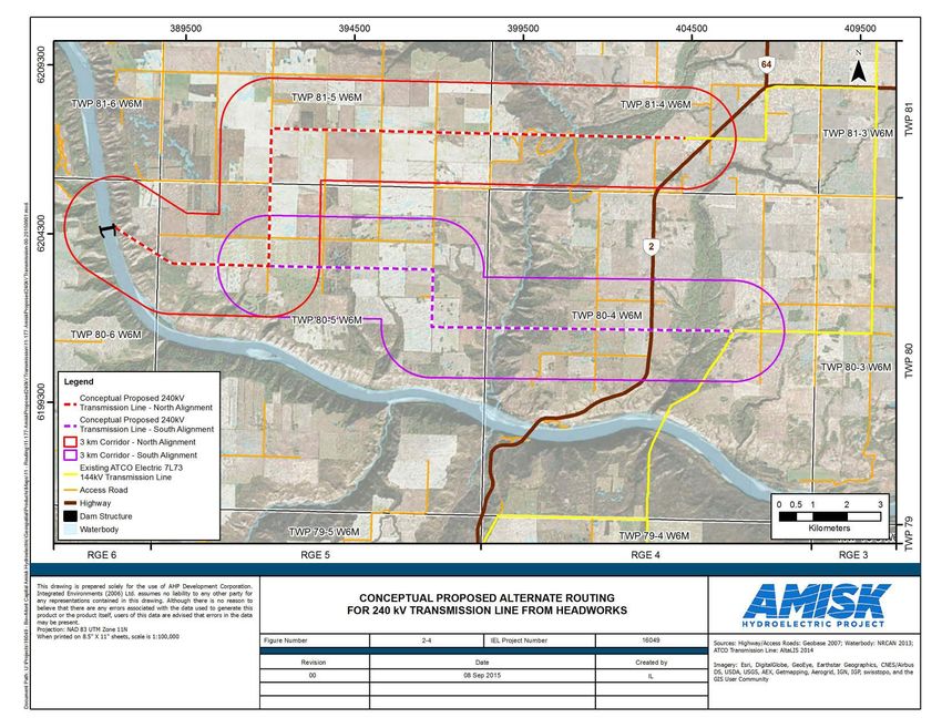
Amisk Hydroelectric Project                Description of a Designated Project                October 2015

Table 1-1: Proponent Information

 Category                                   Details
 Name of Corporation:                       AHP Development Corporation
 Address:                                   50 - 805 5th Avenue SW, Calgary, AB, T2P 0N6
 President and Chief Executive Officer:     Paul McKendrick
 Contact:                                   Paul McKendrick
 Principal Contact for Purposes of Project Description for the Amisk Hydroelectric Project
 Name and Title:                            Paul McKendrick, President
 Email Address:                             pmckendrick@amiskhydro.com
 Contact:                                   1-844-287-1529
 Company Website:                           http://www.amiskhydro.com/

1.3       Consultation Undertaken

AHP has initiated contact and had communications through phone, mail, email and/or face-to-face
meetings with the following entities:

      •    Counties and Municipal Districts (Most Commonly the Chief Administrative Officer)

              •   Birch Hills
              •   Clear Hills
              •   Fairview
              •   Grande Prairie
              •   Greenview
              •   Northern Lights
              •   Northern Sunrise County
              •   Peace River
              •   Saddle Hills
              •   Smoky River
              •   Spirit River

      •    Towns and Cities

              •   Berwyn
              •   Fairview
              •   Falher
              •   Grande Prairie
              •   Grimshaw
              •   McLennan
              •   Nampa
              •   Peace River
              •   Rycroft

 AHP Development Corporation                                                                         Page 2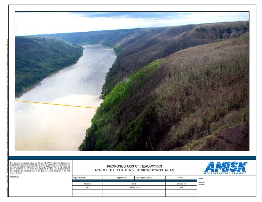
Amisk Hydroelectric Project                Description of a Designated Project    October 2015

   •    Aboriginal Groups

            •    Beaver First Nation
            •    Dene Tha' First Nation
            •    Duncan’s First Nation
            •    Fairview Metis Local (Part of Metis Nation of Alberta, Zone 6)
            •    Fort Chipewyan Metis Local 125
            •    Fort Resolution Metis Council
            •    Fort Smith Metis Council
            •    Horse Lake First Nation
            •    Little Red River Cree Nation
            •    Loon River
            •    Metis Nation Region 6
            •    Mikisew Cree First Nation
            •    Paddle Prairie Metis Settlement
            •    Salt River First Nation #195
            •    Sturgeon Lake First Nation
            •    Tallcree First Nation
            •    Whitefish Lake First Nation
            •    Woodland Cree First Nation

   •    Interest Groups
           • Alberta Conservation Association
           • Alberta Wilderness Association
           • Canadian Parks and Wilderness Society
           • Concerned Residents for Ongoing Service at Shaftsbury (CROSS)
           • Grande Prairie & District Chamber of Commerce
           • Mighty Peace Watershed Alliance
           • Peace Country River Rats
           • Peace Parkland Naturalists
           • Pembina Institute
           • Trout Unlimited
           • River users, including outfitters and tour operators
   •    Landowners and occupants in close proximity to the Project

   •    BC Hydro

AHP Development Corporation                                                             Page 3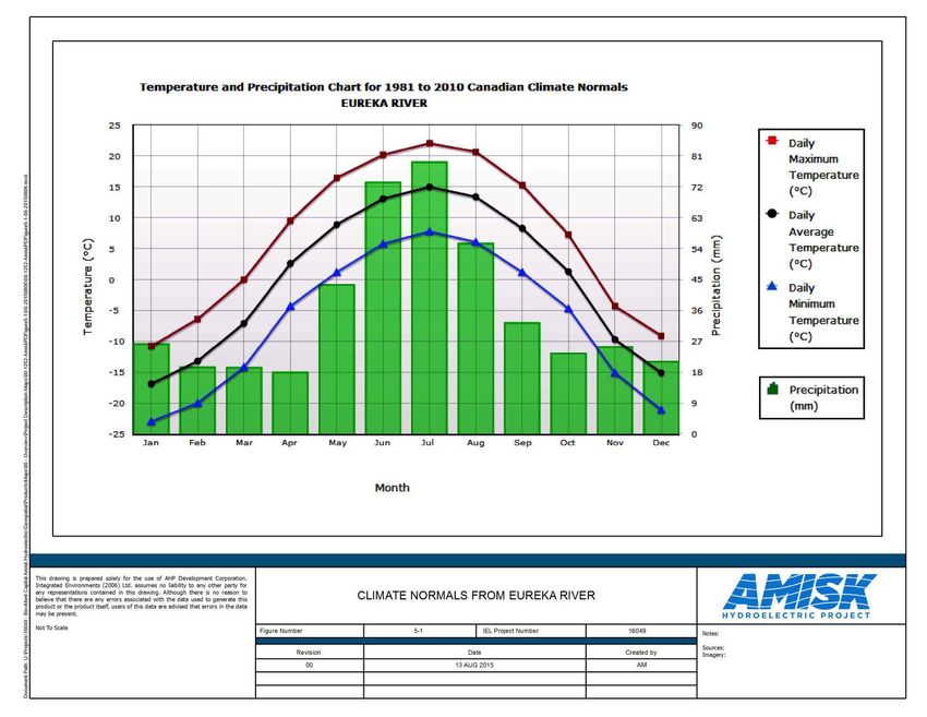
Amisk Hydroelectric Project               Description of a Designated Project               October 2015

1.4    Regulatory Requirements of Other Jurisdictions

In addition to regulatory requirements under the Canadian Environmental Assessment Act 2012 (CEAA
2012), the Project will require additional approvals and compliance, provincial and municipal authorities.
The Project will require an Environmental Impact Assessment (EIA) under the Environmental Protection
and Enhancement Act (EPEA) as regulated by Alberta Environment and Parks (AEP). Applications to the
Natural Resources Conservation Board (NRCB) and the Alberta Utilities Commission (AUC) will also be
required.

Development permits will also be required from the Alberta municipal districts of Clear Hills County,
Saddle Hills County and MD of Fairview No. 136.

1.5    Environmental Studies Conducted in Project Area

In support of the Project’s environmental impact assessment process, a number of environmental
baseline and effects assessments will be completed including: air, fish/aquatics, terrain, vegetation,
wildlife, water quality, surface water flows, sediments and ice formation. Further details regarding
environmental studies are presented in Section 5.0.

There are no regional studies, as defined under CEAA 2012, being conducted in the area.

Previous environmental assessments and panel reports for Glacier Power Ltd.’s Dunvegan Hydroelectric
Project will be reviewed, as will similar documents for the British Columbia Hydro and Power Authority’s
Site C Clean Energy Project.

Information including that from the Northern Rivers Basin Study, the Northern Rivers Ecosystem Initiative,
the Mighty Peace Watershed Alliance, the Mackenzie River Basin Board, and the Peace-Athabasca Delta
Ecological Monitoring Program will also be consulted.

Under the Government of Alberta Land-Use Framework, the Lower and Upper Peace regional plans have
yet to be completed. The Lower Athabasca Regional Plan, which was approved in August 2012, will be
reviewed.

 AHP Development Corporation                                                                       Page 4
Amisk Hydroelectric Project                             Description of a Designated Project                               October 2015

2. PROJECT INFORMATION

2.1            General Description, Context and Objectives

                Project Context and Objectives

The Project is being proposed to provide Alberta electricity consumers with a long-term, reliable, cost
effective supply of renewable electricity.

The electricity market in Alberta is deregulated and therefore left to market participants to add additional
electrical generating capacity when supply and demand fundamentals suggest that additional generation
capacity is warranted. In Alberta, the majority of electricity generated is currently from coal-fired
generation, which contributed approximately 68% of the electricity supplied to the Alberta
Interconnected Electric System (AIES) in 2014. In comparison, hydroelectric generation supplied
approximately 3% 1.

A significant amount of the coal-fired generation in Alberta is approaching retirement, with 3,760 MW
mandated to be retired by 2029 at the latest under the federal government’s Reduction of Carbon Dioxide
Emissions from Coal-Fired Generation of Electricity Regulations. In addition to the federal regulations, the
province has rules regarding other emissions, including NOx and SOx, which were previously agreed to by
the Clean Air Strategic Alliance (CASA). The requirements under CASA could accelerate the retirement of
all coal-fired units, including 2,460 MW of coal-fired generation slated for retirement after 2029 based on
federal regulations.

Sufficient generating capacity must also be added to the AIES to address increasing demand for electricity
in Alberta. Over the last ten years, electricity demand in Alberta has grown by approximately 170 MW per
year 2.

The Project represents an attractive replacement for a portion of the coal-fired fleet slated for retirement
and/or to address electricity demand growth as it will provide a long-term, reliable and cost-effective
source of renewable electricity.

The Project provides the following benefits to Albertans:

           •    Generates 1,875 GWh per year of electricity, which is the equivalent to supplying roughly 250,000
                average Alberta homes;
           •    Supplies renewable electricity that will displace approximately 1.1 million tonnes per year of CO2
                equivalent emissions, which is equivalent to removing over 210,000 cars from the road 3;

1   Alberta Electric System Operator, 2014 Annual Market Statistics Data File

2   Ibid

3
    Based on current Grid Displacement Factor of 0.59 tonnes of CO2e/MWh under Alberta’s Specified Gas Emitters Regulation.

    AHP Development Corporation                                                                                                     Page 5
Amisk Hydroelectric Project Description of a Designated Project October 2015
• Provides a firm and reliable source of renewable electricity throughout the year;
• Be a cost-effective source of renewable electricity; and
• Supports regional and provincial economic development.
General Description of Project Components
The Project is independent and not a component of a larger project. It is a described physical activity
under Schedule 2(c) of the Regulations Designating Physical Activities (SOR/2012-147) as a new
hydroelectric generating facility with a production capacity of 200 MW or more. The Project will generate
330 MW.
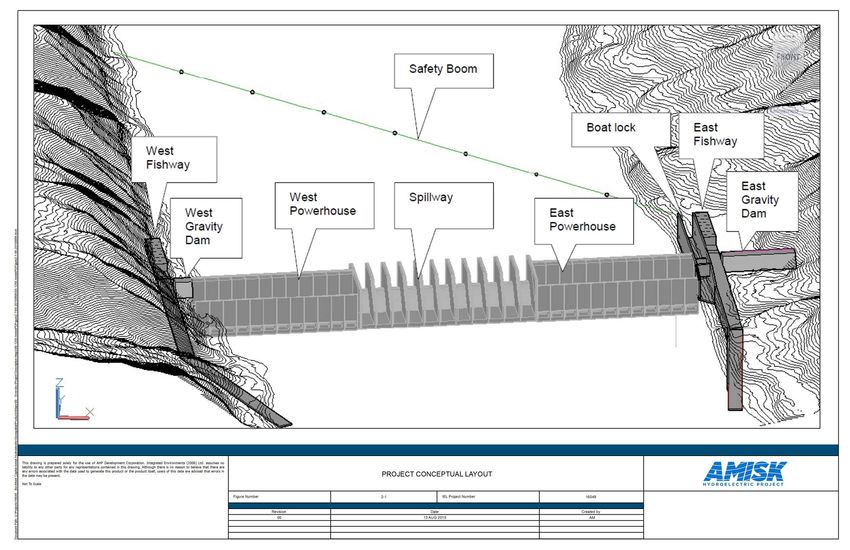
Project engineering is currently at the prefeasibility level. Major Project components consist of an east
and west powerhouse, a spillway, a substation, a transmission line, and access roads. Additional incidental
components under consideration include fish and boat passage. A Project schematic is shown in Figure 2-
1.
The following sections provide additional information on each of the main project components, including:
• Dam;
• Powerhouses;
• Spillway;
• Headpond;
• Substation and Transmission Line;
• Access Roads;
• Fish Passage Facility; and
• Boat Passage Facility.
Project dimensions and levels are conceptual in nature and subject to change, based on the results of the
ongoing preliminary engineering design.
Dam
The east and west powerhouses and the spillway will act collectively as the main dam and have a
combined length of approximately 370 m. The main dam will be constructed across the Peace River, which
is approximately 360 m wide at the proposed facility location 4. The total height of the dam from the
existing river bed will be approximately 24 m and water levels immediately upstream from the dam are
expected to increase by about 17 m over average water levels. The main dam structure will consist of
reinforced concrete; various steel gates which will control headpond levels and water passage. A cut-off
wall will be constructed directly beneath the structures at the upstream side to reduce the uplift pressure
and permeability of the foundation. Two additional gravity dams are anticipated between the
4 As currently planned, the centroid of the dam headworks is located at 55o58’19.6” North latitude and 118o48’28.8” West longitude
AHP Development Corporation Page 6Amisk Hydroelectric Project Description of a Designated Project October 2015 powerhouse and abutments on both sides of the river. These dams may be constructed of concrete, earthfill or roller compacted concrete (RCC). Spillway The spillway will be located at the approximate mid-point of the dam structure in the centre of the river, between the east and west powerhouses, as shown on Figure 2-1. The spillway will pass all Peace River flow not directed through the powerhouses and the fish and boat passage facilities. The spillway is divided into 11 spillway bays, separated by 2 m wide piers. Each spillway bay will be 10 m long, resulting in a total length of about 130 m. Flow through each bay will be controlled by adjustable gates. The type of gates to be used will be determined as the engineering design progresses, although vertical lift gates are currently contemplated. The preliminary inflow design flood for the Project is based on a one in 1,000 year flood event, or approximately 12,300 m3/s. The current configuration of the spillway can pass a flood event of 12,900 m3/s at the proposed headpond Full Supply Level (FSL) of 362.5 masl. The top of the spillway structure is 363.5 masl which provides additional capacity for the spillway. For the larger events, the powerhouse will be designed to overtop, if river flows exceed the spillway capacity. AHP Development Corporation Page 7
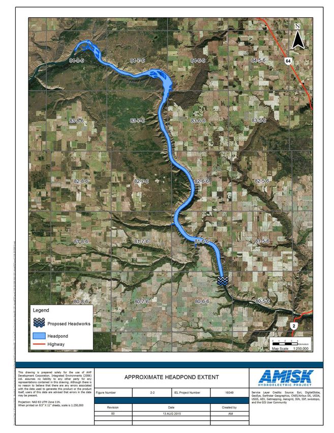
Amisk Hydroelectric Project                Description of a Designated Project                 October 2015

Powerhouses

The facility will consist of two powerhouses; one on the east bank and one on the west bank of the Peace
River. Each powerhouse unit is close-coupled where the intake, turbine passageway, and draft tube form
a single structural element. The current facility design is configured to have a total of 22 turbines (11 per
powerhouse) with a maximum generating capacity of 15 MW each, for an overall facility capacity of
330 MW. Currently, each powerhouse will be approximately 120 m long, including a repair and
maintenance bay, for a combined powerhouse length of 240 m. The number of turbines at each side of
the spillway may be altered in the final design. The upstream side of each powerhouse will have a
foundation (or bottom) elevation of about 336.5 masl and a top elevation of 363.5 masl. Ongoing
geotechnical investigation and additional engineering design will confirm these elevations and finalize
turbine generator orientation (i.e. whether vertical or horizontal). The rated discharge capacity of each
turbine is anticipated to be approximately 80 m3/s, resulting in an overall capacity of approximately
1,760 m3/s combined for the two powerhouses. The turbines are currently anticipated to be propeller
turbines installed in an “S” configuration, although this will be confirmed during future design phases.

The powerhouses will consist of an excavated intake channel to transition from the existing river bed to
the base of the powerhouse, with an intake structure consisting of trashracks to prevent passage of debris
through the turbines and fixed wheel vertical lift maintenance gates to facilitate dewatering of turbines.

A tailrace will be excavated downstream from the powerhouse to transition from the draft tube level back
up the existing river bed. Provisions will be made in the intake and or draft tubes to allow for dewatering
of individual turbine units. A riprap apron will be installed, extending approximately 40 m downstream
from the powerhouse to prevent riverbed scour.

Headpond

The anticipated FSL of 362.5 masl is anticipated to increase the water level of the Peace River immediately
upstream from the dam by approximately 17 m during average flow conditions. The existing Peace River
channel at the dam location is approximately 4-5 m deep during average flow conditions. This will create
a headpond that will extend approximately 50 km upstream and will inundate approximately 800 hectares
(ha) (8 km2) of the Peace River valley walls. The headpond (including the existing river channel and
incremental inundated area) will have an overall surface area of approximately 30 km2 (Figure 2-2). The
existing river channel averages 350-400 m wide but is up to approximately 1 km wide in some locations
within the proposed headpond. The average width of the headpond is anticipated to be 400 m. The
headpond is anticipated to be contained within the existing Peace River valley, without resulting in
extensive inundation of the existing riparian parts of the valley or adjacent tablelands. No significant
inundation of existing tributaries of the Peace River is expected. The longitudinal and lateral extent of the
headpond will be confirmed after initial survey completion.

 AHP Development Corporation                                                                          Page 9
Amisk Hydroelectric Project                     Description of a Designated Project                       October 2015

Bathymetric Data: Natural Waterway versus Headpond

A bathymetric survey was conducted from May 21 to 31, 2015. Table 2-1 provides data of the bed
elevation with distance upstream of the headworks along with surveyed versus headpond water level,
maximum depth and top width. Figure 2-3 shows graphical representations of the information presented
in Table 2-1 with maximum width of the Peace River occurring at approximately 40 km upstream of the
headworks and maximum depth between Montagneuse Islands and Many Islands (approximately 45 km
upstream from the headworks).

Table 2-1: Summary of widths and depths in Amisk headpond reach of the Peace River

  Distance              Bed         Surveyed       Headpond        Surveyed        Headpond        Surveyed       Headpond
 Upstream of         Elevation       Water          Water          Maximum         Maximum        Top Width       Top Width
    Dam                               Level          Level          Depth           Depth
     (m)                (m)            (m)            (m)             (m)             (m)              (m)            (m)
     150               338.93        345.32         362.50           6.39            23.57             345            402
    5000               340.95        346.88         362.50           5.93            21.55             544            630
   10000               342.19        348.39         362.50           6.20            20.31             436            581
   15000               341.21        349.79         362.50           8.57            21.29             359            530
   20000               344.33        350.97         362.50           6.63            18.17             451            545
   25000               344.27        352.11         362.50           7.84            18.23             318            461
   30000               347.50        353.65         362.50           6.15            15.00             365            418
   35000               349.36        355.18         362.50           5.82            13.14             339            386
   40000               352.43        358.09         362.50           5.65            10.07            1119           1161
   45000               345.68        359.67         362.50           13.99           16.82             235            303
   50000               353.14        360.84         362.50           7.71            9.36              322            354
   54000               355.65        362.22         362.50           6.57            6.85              903            909
NOTES:
    •    Headpond condition assumes a constant elevation of 362.5 m
    •    Surveyed channel widths ignore the presence of islands (far right bank to far left bank)
    •    Surveyed depths are the maximum depths on the day of survey (May 21-31) at a higher than average discharge of
         about 2100 m3/s.
    •    (Lower depths will occur with lower discharge)

 AHP Development Corporation                                                                                     Page 11
Amisk Hydroelectric Project Description of a Designated Project October 2015 Substation and Transmission/Power Supply Line A substation containing switchgear and transformers will be located onsite to transform power generated by the facility to the transmission voltage of 240 kV. A new, approximately 25 km long transmission line will be required to connect the Project to the Alberta Interconnected Electricity System (AIES) located east of the site. The exact location of the transmission line has yet to be determined. The general corridor, through which potential transmission rights-of-way is expected to be located, is shown in Figure 2-4. The right-of-way width for the transmission connection could range from 35 – 74 m and will be confirmed once more Project details become available. AHP Development Corporation Page 13
Amisk Hydroelectric Project               Description of a Designated Project                 October 2015

Access Roads

Permanent road access to the site will be provided on both the east and west sides of the Peace River
valley via connections with existing local roads. Figure 2-5 shows corridors within which these access roads
may be constructed. A total of 7 km of new access roads will be required for both sides of the Peace River.
Anticipated grades will not exceed 8% and roads will be designed to accommodate two-way construction
traffic. The access road width is anticipated to be approximately 7 – 10 m, but this is subject to
confirmation during the design process. In addition to new roads, approximately 18 km of existing roads
will require upgrading to handle the anticipated construction traffic.

 AHP Development Corporation                                                                        Page 15
Amisk Hydroelectric Project                 Description of a Designated Project                  October 2015

Fish Passage
To date, criteria required for managing upstream fish passage is under development. The Project has
initially made an allowance to accommodate upstream fish passage. Consultation with Fisheries and
Oceans Canada is planned to establish regulatory requirements including the species requiring passage
which is anticipated to dictate the type of fish passage facility that will be required.

Boat Passage
The Peace River between Williston Headpond and the Slave River is explicitly classified as a navigable
waterway under the Navigation Protection Act (NPA). Regulatory approval under the NPA is expected to
be required for the Project. Consultation with Transport Canada (Navigation Protection Program) is
planned to establish regulatory requirements. AHP is currently evaluating a number of options for boat
passage including a possible boat lock, portage system or a combination of boat launches.

2.2       Project Activities

Project construction and operation phases are described below.

           Construction

Construction of the proposed facility is scheduled to take place over approximately five years from 2018
to 2023. A detailed construction schedule will be prepared as part of the Project application process and
will take into consideration potential environmental constraints including work to avoid sensitive timing
windows and to minimize Project effects on breeding birds and other wildlife species.

Construction activity details will be developed as part of Project feasibility study, but it is anticipated that
construction would likely include the following activities (with potential timing and duration in
parentheses):

Site Preparation (2018)
      •    Installation of sediment and erosion controls, as required prior to ground disturbance;
      •    Installation of construction camp (if required), including provisions for potable water and sewage
           collection/discharge;
      •    Construction of permanent granular access roads to each side of the proposed facility, with
           activities including:
               • Vegetation clearing;
               • Topsoil stripping;
               • Grading and foundation preparation;
               • Installation of granular fill (granular sources to be determined);
               • Ditching and other stormwater/erosion and sediment control mitigation; and
      •    Construction of works and laydown areas, including office facilities.

 AHP Development Corporation                                                                           Page 17
Amisk Hydroelectric Project Description of a Designated Project October 2015
Stage 1 Construction (2018-2020)
• Installation of the first stage cofferdam in the river to facilitate construction of facilities on one
side of the river (e.g. powerhouse, fish passage facility, partial portion of spillway) in a dry
condition. Potential cofferdam designs to be determined during future engineering phases.
• Construction of facilities behind the cofferdam, with general construction activities including:
• Mechanical excavation of existing soils and sediments (temporary and/or permanent disposal
on or off-site to be determined);
• Bedrock excavation (if required) mostly mechanical removal (temporary and/or permanent
disposal locations on or off-site to be determined). Some local blasting may be required for
large boulders;
• Installation of water management measures within excavation;
• Foundation preparation;
• Installation of formwork and concrete for powerhouse and spillway (on-site requirements for
a concrete batch plant to be determined); and
• Installation of powerhouse and spillway mechanical equipment (e.g., spillway gates, turbines,
generators) as well as balance of plant equipment (e.g. electrical, HVAC, water supply,
sewage, office facilities, etc.)
• Commissioning of water passage through partially constructed spillway and/or powerhouse, and
removal of Stage 1 cofferdam.
Stage 2 Construction (2021-2023)
• Installation of Stage 2 cofferdam to construct the remaining portion of facility, with all flow
diverted through the portion of the facility constructed during Stage 1;
• Construction of remaining facilities within the area dewatered behind the Stage 2 cofferdam;
• Removal of Stage 2 cofferdam;
• Construction of substation and transmission line, including vegetation removal within right-of-
way;
• Headpond preparation including vegetation removal within the anticipated inundation area (as
necessary);
• Inundation of headpond by slowly decreasing flow through powerhouse/spillway (maintaining a
minimum downstream flow at all times);
• Testing and commissioning; and
• Site rehabilitation (e.g. stabilization, re-vegetation, removal of all temporary features).
The staging noted above is subject to change pending the completion of the Feasibility Study.
AHP Development Corporation Page 18Amisk Hydroelectric Project Description of a Designated Project October 2015
Operation
The Project will operate as a run-of-river facility, which is a term used to describe hydroelectric facilities
that do not have significant long-term storage. 5 It will operate with a full supply level (FSL) of about
362.5 masl. This would result in a total headpond volume of about 124,000,000 m3. The potential for a
limited amount of drawdown during times of peak demand and/or supply shortfall on the Alberta
electricity grid is currently under evaluation.
Flow up to the facility’s capacity (approximately 1,760 m3/s) will be directed through the powerhouse and
turbines, and any flow required for operation of the fish and boat passage facilities will be passed through
those facilities. All excess flows over and above this amount will be passed through the spillway. It is
anticipated that the powerhouses and spillway will be operated to maintain the headpond within a narrow
band around the FSL in order to ensure the run-of-river mode of operation is maintained. Due to this run-
of-river mode of operation, there will not be a meaningful change to existing flow patterns in the Peace
River.
An operating plan will be prepared as part of the Project application process and it is anticipated that the
facility will be required to monitor river flow and water levels on a regular basis.
The facilities will be designed for remote operation in addition to having on-site controls. It is anticipated
that at least one permanent operator will be at the facility on a regular basis.
Regular facility monitoring, periodic testing (e.g. backup diesel generators, if present) and routine
maintenance will be conducted throughout the life of the facility.
Routine maintenance may include items such as:
• Access road grading, granular addition, dust suppression and snow ploughing and/or de-icing;
• Grass cutting around the facility;
• Periodic tree/shrub removal along the transmission line corridor;
• Mechanical equipment maintenance (e.g. fluid changes); and
• Concrete spot repairs.
Decommissioning
Presently, there are no plans to decommission the Project. Upgrading or rehabilitation to extend the
facility’s life will take place as part of major maintenance expenditures and depend on the condition of
the plant and equipment. Decommissioning, if required, would typically occur 100 years or later following
construction. It would depend on the structural/historic attributes of the facility as well as economic and
financial considerations at the time. The decision on decommissioning (or alternatively upgrading or
5
Run-of-river implies a less than 48 hour retention time for river flows in the headpond according to the Quantification Protocol for Run-of-River
Projects under Alberta’s Specified Gas Emitters Regulation.
AHP Development Corporation Page 19Amisk Hydroelectric Project Description of a Designated Project October 2015
further rehabilitation to extend facility life) will depend on numerous factors which will be considered. A
Conceptual Decommissioning Plan will be prepared as part of the Project application process.
2.3 Emissions, Discharges and Waste
Atmospheric Emissions
During construction, gaseous emissions to the atmosphere will occur from various pieces of operating
construction equipment, including heavy machinery and generators. Blasting, if required, may also result
in periodic air emissions during construction. It is not anticipated that any explosives will be manufactured
on-site. Any explosives stored on-site will be contained in a manner compliant with Natural Resources
Canada requirements and industry standards. Transport of explosives will be done in accordance with
Transport Canada requirements (i.e. Transportation of Dangerous Goods Regulations). Fugitive dust may
also occur periodically during construction.
Gaseous wastes from the facility are not anticipated to occur during normal operations, although air from
the powerhouse will be vented through the facility’s HVAC system. This is not anticipated to include any
potentially harmful gases or particles. However, periodic operation of back-up diesel generators (during
testing and on an as-required basis during power outages) would result in some air emissions.
Liquid Discharges
Industrial Liquids
Fuels, hydraulic fluids, and lubricants will be used in equipment during Project construction and operation.
The storage facilities for these materials will comply with all current regulations and guidelines.
No specific discharge of these materials is anticipated to occur during Project construction. A spill
prevention and response plan will be prepared and implemented throughout the construction process to
ensure that accidental spills are prevented to the best extent practicable, and that mitigation measures
are implemented to minimize negative effects in the event of an accidental spill.
An operational spill prevention and response plan will be prepared and implemented during long-term
operation of the facility. This will include specific protocols on storage, handling and use of industrial
liquids at the facility. In addition, spill containment facilities are anticipated to be included in the
powerhouses and at the substation to prevent accidental discharge of industrial liquids to the
environment, should a spill occur.
Any waste fluids generated during construction or operations will be retained in an appropriate storage
container and transported and disposed off-site at an appropriate disposal facility, in accordance with all
regulatory requirements.
Water Management during Construction
It is anticipated that stormwater management and/or sediment control ponds will be required during
construction to manage stormwater and/or water seeping into excavations and prevent discharge of
sediment laden water back to the Peace River. The locations for these facilities have not been determined
but it is anticipated that they will be required on both sides of the Peace River and will discharge back to
AHP Development Corporation Page 20Amisk Hydroelectric Project Description of a Designated Project October 2015
the river downstream from the work area. Treatment requirements and control measures will be
determined during the Project application process.
It is anticipated that the powerhouse will discharge water that may accumulate within the structure,
through a sump pump or other similar system. Spill containment measures will be in place to prevent
discharge of industrial liquids through this system in the event of an accidental spill inside the
powerhouse.
Sewage
Human sewage generated during construction at the camp (if required) and working areas will either be
contained and hauled off-site or treated through an appropriately designed sewage treatment or disposal
system.
It is anticipated that the powerhouses will have washroom and sink facilities. The method of collection
and treatment of sewage from these features has not yet been determined, but it is anticipated that
sewage will either be collected and transported off-site or treated and disposed in an appropriate
designed sewage treatment or disposal system.
Waste Disposal
Solid nonhazardous construction waste (e.g. material packaging), generated during the construction
process, will be removed from the site to an approved disposal location (likely a municipal landfill) or
recycling/composting facility, as available. Waste debris from clearing activities (e.g. grubbing, non-
merchantable timber) will be disposed of in accordance with regulatory requirements. Industrial liquids
such as paints, sealants, fuels, and lubricating fluids will be stored in a secure containment area and
disposed in accordance with applicable regulations.
AHP Development Corporation Page 21Amisk Hydroelectric Project Description of a Designated Project October 2015
3. PROJECT LOCATION
3.1 Description of Project Location and Site Plan
Project Coordinates
The proposed Project would be located on the Peace River in northwestern Alberta approximately 28 km
southwest from the town of Fairview.
As currently planned, the centroid of the dam headworks are located at 55o58’19.6” North latitude and
118o48’28.8” West longitude and the western extent of its headpond at 56o18’05” North latitude and
119o11’45” West longitude. .
Site Plan
The Project headworks and an approximately 50 km long headpond constitute the Project area as shown
in the site map (Figure 3-1). The right and left banks of the Peace River, upstream of the headworks consist
generally of steep valley walls that have been dissected by frequent large gullies and ravines.
Project Maps
A series of maps are presented in Figures 3-1 through 3-4 showing the following information:
• Named watercourses and waterbodies;
• Linear infrastructure;
• Land use;
• Location of nearby aboriginal settlements;
• Federal lands;
• Nearby communities;
• Land ownership;
• Environmentally sensitive areas; and
• Provincial and international boundaries.
Text descriptions to the maps are also provided.
AHP Development Corporation Page 22Amisk Hydroelectric Project Description of a Designated Project October 2015 Waterbodies and Fishing Areas There are several watercourses which drain into the segment of the Peace River encompassed by the Project area: Blueberry, Hamelin, Josephine, Mulligan, and Fourth Creeks (near the headworks) and the Montagneuse River (approximately 38 km upstream from the headworks). A number of unnamed tributaries flow into the Peace River between the headworks and the upstream extent of the headpond. Numerous small waterbodies (wetlands) occur within the Project area. Aboriginal and recreational fishing areas are yet to be determined. There are three boat launches currently located along the proposed headpond and one downstream of the headworks (Figure 3-2). Existing Infrastructure One railway line runs northeast of the Project area and there are several roads in proximity, with the Dunvegan Bridge crossing the Peace River approximately 15 km downstream of the headworks. No pipelines have been identified crossing the Peace River within the Project Area, although several, related to oil and gas activities, are in proximity (Figure 3-4). There is one major electrical transmission line which crosses the Peace River at approximately 51 km upstream of the headworks (just east of Many Islands). At least 13 groundwater wells are located within 1 km from the midstream of the Peace River (Figure 3- 4) between the headworks and the western extent of the headpond. These wells consist of domestic, industrial, municipal, observation and structure test holes uses. A search made on AEP’s Authorization Viewer on August 31, 2015 for municipalities within the Project area identified licensees holding surface water diversion licenses for the Peace River. Land Use Features of existing and past land uses are shown in Figure 3-2. Locations of Aboriginal groups and settlement land are shown in Figure 3-4. Duncan’s First Nation and Horse Lake First Nation are approximately 60 and 90 km away respectively from the Project. The Peavine (Métis) Settlement is approximately 159 km from the Project area. The location of traditional territory and its proximity to the Project area is still to be determined and is therefore not shown. Several small communities are in proximity to the Project area, the largest being the town of Fairview (Figure 3-4). There are at least three permanent residences on the east side of the Project area at approximately 5.5, 6, and 18 km upstream from the headworks. Seasonal residences are located at Pratt’s landing and Carter Camp at approximately 12 and 38 km upstream from the headworks (Figure 3-2). Environmentally Sensitive Areas The Project is located within the Dunvegan West Wildland Provincial Park on the west bank of the river. This 20,968 ha park was established in 2000 and includes a unique mixture of grassland, aspen forest and steep-sided creek valleys. Several plants and birds located in the park are more typical of those in the Foothills Parkland subregion. The areas of the park are limited to unleased Alberta Crown land resulting in a non-contiguous park boundary (ATPR, 2014). AHP Development Corporation Page 27
You can also read