Cork Line Level Crossings - Volume 3, Chapter 12: Cultural Heritage Iarnród Éireann March 2021 - Irish Rail
←
→
Page content transcription
If your browser does not render page correctly, please read the page content below
Cork Line Level Crossings
                                      Volume 3, Chapter 12: Cultural Heritage
                                                             Iarnród Éireann

                                                                 March 2021

EIAR Chapter 12 C ultural H eritage
Iarnr ód Éir eann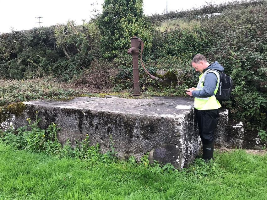
Volume 3, Chapter 12: Cultural Heritage

Cork Line Level Crossings

Project No:                    32111000
Document Title:                EIAR Chapter 12 Cultural Heritage
Document No.                   12
Revision:                      A04
Date:                          March 2021
Client Name:                   Iarnród Éireann
Project Manager:               Alex Bradley
Author:                        AMS Ltd

Jacobs U.K. Limited
Artola House
3rd & 4th Floors
91 Victoria Street
Belfast
BT1 4PN
T +44 (0)28 9032 4452
F +44 (0)28 9033 0713
www.jacobs.com

© Copyright 2021 Jacobs U.K. Limited. The concepts and information contained in this document are the property of Jacobs. Use or copying of
this document in whole or in part without the written permission of Jacobs constitutes an infringement of copyright.

Limitation: This document has been prepared on behalf of, and for the exclusive use of Jacobs’ client, and is subject to, and issued in accordance with, the
provisions of the contract between Jacobs and the client. Jacobs accepts no liability or responsibility whatsoever for, or in respect of, any use of, or reliance
upon, this document by any third party.

Document history and status

 Revision         Date            Description                                                 Author          Checked          Reviewed        Approved

 A01              December        Client Review                                               AMS             AMS              RM              AB
                  2019

 A02              November        Interim Draft pending Archaeological                        AMS             HC               HC              AB
                  2020            Investigations

 A03              March           Final draft                                                 AMS             AMS              RM              AB
                  2021

 A04              March           For Issue to An Bord Pleanála                               AMS             AMS              HC/RM           AB
                  2021

                                                                                                                                                                i
Volume 3, Chapter 12: Cultural Heritage

Contents
12.          Cultural Heritage .................................................................................................................................................... 1
12.1         Introduction .............................................................................................................................................................................. 1
12.2         Study Area ................................................................................................................................................................................. 1
12.3         Assessment Methodology ................................................................................................................................................... 2
12.3.1 Legislation, Policy & Guidance ........................................................................................................................................... 2
12.4         Baseline data gathering........................................................................................................................................................ 3
12.4.1 Consultation .............................................................................................................................................................................. 5
12.4.2 Assessment of Importance .................................................................................................................................................. 5
12.4.3 Impact Assessment ................................................................................................................................................................ 6
12.5         Baseline Environment ........................................................................................................................................................... 6
12.5.1 Archaeological and Historical Context of the Overall proposed Project .......................................................... 6
12.5.2 Cultural Heritage Policy Context: Cork County Development Plan 2014 ..................................................... 19
12.5.3 Cultural Heritage Policy Context: Limerick County Development Plan 2010 ............................................. 21
12.5.4 XC187 Fantstown ................................................................................................................................................................ 22
12.5.5 XC201 Thomastown ........................................................................................................................................................... 23
12.5.6 XC209 Ballyhay .................................................................................................................................................................... 24
12.5.7 XC211 & XC212 Newtown and Ballycoskery ............................................................................................................ 25
12.5.8 XC215 Shinanagh ................................................................................................................................................................ 27
12.5.9 XC219 Buttevant .................................................................................................................................................................. 30
12.6         Potential Effects of the proposed Project .................................................................................................................. 32
12.6.1 XC187 Fantstown ................................................................................................................................................................ 32
12.6.2 XC201 Thomastown ........................................................................................................................................................... 33
12.6.3 XC209 Ballyhay .................................................................................................................................................................... 33
12.6.4 XC211 & XC212 Newtown and Ballycoskery ............................................................................................................ 34
12.6.5 XC215 Shinanagh ................................................................................................................................................................ 36
12.6.6 XC219 Buttevant .................................................................................................................................................................. 37
12.6.7 Combined Effects of all Sites........................................................................................................................................... 39
12.7         Mitigation Measures ........................................................................................................................................................... 40
12.8         Residual Effects .................................................................................................................................................................... 42
12.9         Interactions............................................................................................................................................................................. 48
12.10 Cumulative Effects ............................................................................................................................................................... 48
12.11 Difficulties Encountered in Compiling Information ................................................................................................ 48
12.12 References .............................................................................................................................................................................. 49

Appendix 12A. Cultural Heritage Inventories
Appendix 12B. DAU Scoping Opinion (July 2020)
Appendix 12C. DAU Mitigation Letter (February 2021)
Appendix 12D. AMS Draft Screening Report (June 2019)
Appendix 12E. Geophysical Survey Report Newtown (AMS, March 2020)

                                                                                                                                                                                                              ii
Volume 3, Chapter 12: Cultural Heritage

Appendix 12F. Geophysical Survey Report Imphrick (AMS, March 2020)
Appendix 12G. Geophysical Survey Report Newtown and Shinanagh (TAG, June 2020)
Appendix 12H. Geophysical Survey Report Thomastown, Ballycoskery, Shinanagh and Buttevant (ACSU
      December 2020)
Appendix 12I. Archaeological Test Excavation Report, Newtown (ACSU, December 2020)
Appendix 12J. Archaeological Test Excavation Report, Shinanagh (ACSU, December 2020)
Appendix 12K. Topographical Survey Report, Imphrick (ACSU, December 2020)
Appendix 12L. Archaeological Monitoring Report, Thomastown, Newtown, Ballycoskery, Imphrick, Creggane
      (TVAS, August 2020)

Table 12. 1: Consultation .................................................................................................................................................................... 5
Table 12. 2: XC187 (Fantstown) Cultural Heritage baseline conditions ....................................................................... 22
Table 12. 3: Townlands within the XC187 (Fantstown) study area ................................................................................. 23
Table 12.4: XC201 (Thomastown) Cultural Heritage baseline conditions ................................................................... 24
Table 12.5: Townlands within the XC201 (Thomastown) study area ............................................................................. 24
Table 12.6: XC209 (Ballyhay) Cultural Heritage baseline conditions ............................................................................ 25
Table 12.7: Townlands within the XC209 (Ballyhay) study area ...................................................................................... 25
Table 12.8: XC211 & XC212 Newtown and Ballycoskery Cultural Heritage baseline conditions ....................... 26
Table 12.9: Townlands within the XC211 & XC212 Newtown and Ballycoskery study area ................................. 27
Table 12.10: XC215 Shinanagh Cultural Heritage baseline conditions ........................................................................ 29
Table 12.11: Townlands within the XC215 Shinanagh study area .................................................................................. 29
Table 12.12: XC219 Buttevant Cultural Heritage baseline conditions .......................................................................... 31
Table 12.13: Townlands within the XC219 Buttevant study area .................................................................................... 31
Table 12.14: Predicted construction impacts on cultural heritage at XC187 Fantstown ....................................... 32
Table 12.15: Predicted construction impacts on cultural heritage at XC201 Thomastown.................................. 33
Table 12.16: Predicted construction impacts on cultural heritage at XC209 Ballyhay........................................... 34
Table 12.17: Predicted construction impacts on cultural heritage at XC211 & XC212 Newtown and
       Ballycoskery ........................................................................................................................................................................... 35
Table 12.18: Predicted construction impacts on cultural heritage at XC215 Shinanagh ...................................... 36
Table 12.19: Predicted construction impacts on cultural heritage at XC219 Buttevant ........................................ 38
Table 12.20: Combined effects – construction phase (slight or above) ........................................................................ 39
Table 12.21: Combined effects – operational phase (slight or above) .......................................................................... 40
Table 12.22: Predicted residual construction impacts on archaeological heritage sites ....................................... 43
Table 12.23: Predicted residual construction impacts on architectural heritage sites ........................................... 45
Table 12.24: Predicted residual construction impacts on other cultural heritage assets ...................................... 46

Plate 12. 1: Humpbacked railway bridge at Ballinscaula, XC187, looking north (AH001) .................................... 52
Plate 12. 2: Masonry surround for timber water pump (overgrown), XC187, in Gibbonstown (AH003) ......... 52
Plate 12. 3: Area of potential rectangular earthwork enclosure (AY026), XC212, looking W .............................. 53
Plate 12. 4: Remains of the W bank of moated site CO008-035 (AY020), XC212, looking N ............................. 53

                                                                                                                                                                                                     iii
Volume 3, Chapter 12: Cultural Heritage
Plate 12. 5: Moated site CO008-035 possible leat (AY020a), XC212, looking N, with higher ground to E ... 54
Plate 12. 6: Farmhouse AH012 and gate piers, XC212, looking N .................................................................................. 54
Plate 12. 7: Garden and outbuildings associated with farmhouse AH012, XC212, looking W ............................ 55
Plate 12. 8: Wrought iron gate to farmhouse AH012 garden from L1533 road, XC212, looking S .................. 55
Plate 12. 9: Entrance to the Parochial House (AH011), XC212 ........................................................................................ 56
Plate 12. 10: Detail of gate piers and gate to Parochial House (AH011), XC212 ..................................................... 56
Plate 12. 11: Former gatekeeper's house (AH013) at Ballycoskery, XC212 ............................................................... 57
Plate 12. 12: Field looking NW towards archaeological monument CO008-034 (AY019), XC211 .................. 57
Plate 12. 13: Imphrick church and graveyard, looking W (AY029 & AY030), XC215 .............................................. 58
Plate 12. 14: Raised earthen platform and possible paleochannel (AY036) north of Imphrick church, XC215
..................................................................................................................................................................................................... 58
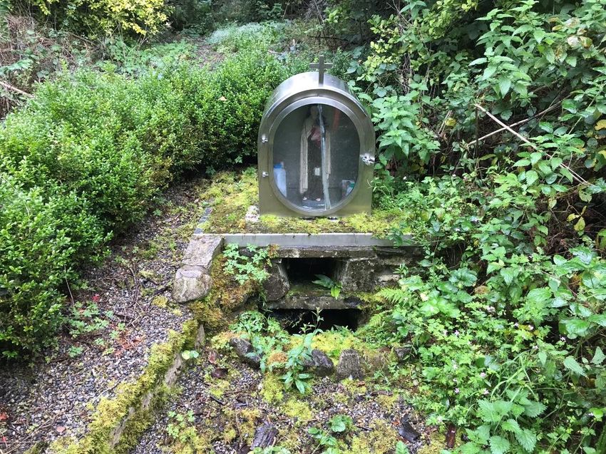
Plate 12. 15: Holy well at Imphrick (AY031), XC215 ............................................................................................................ 59
Plate 12. 16: Roadside water pump at Shinanagh (AH014), XC215 .............................................................................. 59
Plate 12. 17: Remains of the western goods shed and wrought-iron steps at Buttevant Station (AH020),
XC219 ....................................................................................................................................................................................... 60
Plate 12. 18: Kerbstones on the approach to Buttevant Station (AH021), XC219 ................................................... 60
Plate 12. 19: Buttevant Station (AH020) including former post office (centre) and goods shed (AH019,
right), XC219 ......................................................................................................................................................................... 61
Plate 12. 20: Platform and railway sidings to goods shed east of the railway line at Buttevant Station
(AH020), XC219 ................................................................................................................................................................... 61
Plate 12. 21: Blocked pedestrian entrance to Buttevant Station (AH020), XC219 .................................................. 62
Plate 12. 22: Former footbridge, reused as steps to gatekeeper's hut, XC219 Buttevant (AH020), XC219 .. 63
Plate 12. 23: Former platform to be impacted at Buttevant Station (AH020), XC219 ........................................... 64
Plate 12. 24: Former waiting room at Buttevant Station (AH020), XC219 .................................................................. 64
Plate 12. 25: Interior of boundary wall which surrounds the former railway station at Buttevant (AH020),
XC219 ....................................................................................................................................................................................... 65
Plate 12. 26: Former railway siding to be impacted at Buttevant Station (AH020), XC219 ................................. 65
Plate 12. 27: Memorial to the Buttevant Rail Disaster in 1980, XC219 ........................................................................ 66
iv
Volume 3, Chapter 12: Cultural Heritage

Table of Acronyms
Abbreviation                    Meaning

ACSU                            Archaeological Consultancy Services Unit Ltd

AMS                             Archaeological Management Solutions Ltd

BGE                             Bord Gáis Éireann

CDP                             County Development Plan

DAU                             Development Applications Unit

DHLGH                           Department of Housing, Local Government and Heritage

DIER                            Database of Irish Excavation Reports

DRI                             Digital Repository of Ireland

EIA                             Environmental Impact Assessment

EIAR                            Environmental Impact Assessment Report

EPA                             Environmental Protection Agency

GS&WR                           Great Southern and Western Railway

HEV                             Historic Environment Viewer

HMV                             Heritage Map Viewer

LC                              Level Crossing

M                               Metres

NIAH                            National Inventory of Architectural Heritage

NMI                             National Museum of Ireland

NMS                             National Monuments Service (DHLGH)

NRA                             National Roads Authority

OS                              Ordnance Survey

RMP                             Record of Monuments and Places

RPS                             Record of Protected Structures

SMR                             Sites and Monuments Record

TAG                             Target Archaeological Geophysics

TII                             Transport Infrastructure Ireland

                                                                                       v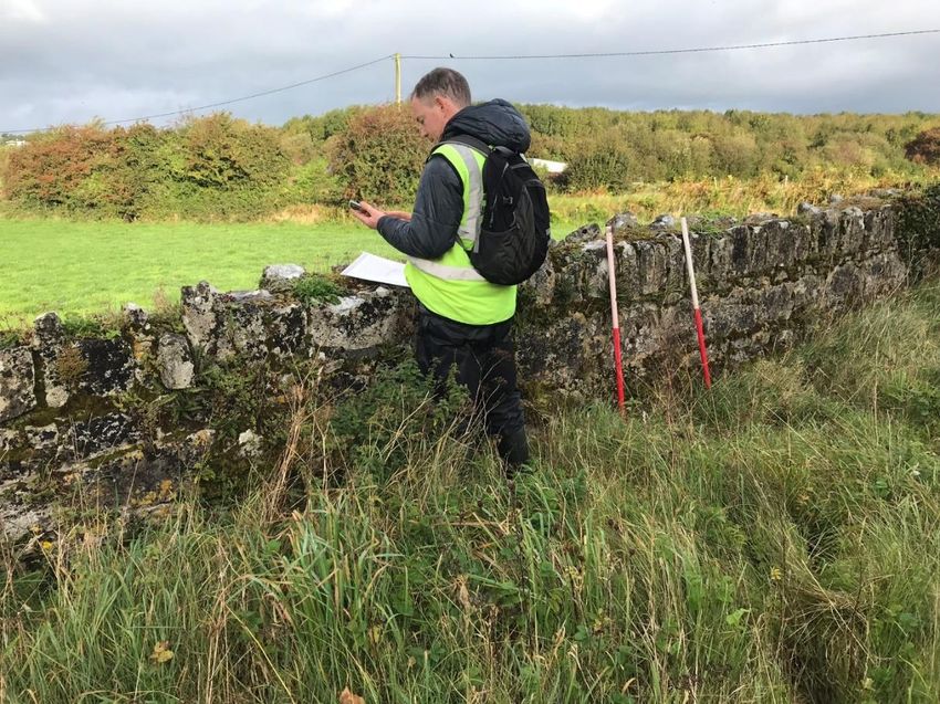
Volume 3, Chapter 12: Cultural Heritage

12.            Cultural Heritage
12.1           Introduction

This chapter assesses the likely impact and significance of effect on cultural heritage as a result of the construction
and operation of the proposed Project. It was prepared by Archaeological Management Solutions Ltd (AMS) on
behalf of Jacobs.

Under the Draft Guidelines on the Information to be contained in Environmental Impact Assessment Reports (EPA
2017, 33) (see Volume 2, Chapter 4: EIA Process and Methodology), cultural heritage 1 is made up of three
subcategories:
       1. Archaeology
                  a.   Known archaeological monuments;
                  b. Areas of archaeological potential (including unknown archaeology); and
                  c.   Underwater archaeology.
       2. Architectural heritage
                  a.   Designated architectural heritage; and
                  b. Other significant architectural heritage.
       3. Folklore and history

Archaeology is the study of past societies through surviving structures, artefacts and environmental data.
Archaeological sites and monuments are protected under the National Monuments Act 1930 to 2014 (see 12.3.1
for further discussion). Architectural heritage comprises structures, buildings, traditional and designed, and groups
of buildings including streetscapes and urban vistas, which are of historical, archaeological, artistic, engineering,
scientific, social or technical interest, together with their setting, attendant grounds, fixtures, fittings and contents
(NRA 2005a:56). Architectural heritage and archaeology together form the ‘built heritage’. ‘Cultural assets’ in the
existing environment are those aspects of the environment “which are valued because of their age, history, beauty
or tradition. Some of these topics are the subject of highly developed fields of academic study, some may be of
interest only to the people of the local parish” (EPA 2003). The Environmental Protection Agency (EPA) Advice
Notes on Current Practice (EPA 2003) divide cultural assets into physical and social types, with folklore and
tradition classed as part of the latter.

12.2           Study Area

An overall study area encompassing a corridor 2km wide around the Dublin–Cork Railway Line between Knocklong
West to the east of XC187 Fantstown and Ballybeg to the south of XC219 Buttevant was used to set the proposed
Project into its archaeological and historical context (Volume 4). For each site, a more focused study area
encompassing c.500m surrounding the proposed Project footprint was used to identify the existing baseline and
assess the likely effects during construction and operation. These study areas were established on the basis of
professional judgement as being sufficient to identify the likely significant effects of the proposed Project on
cultural heritage, and exceed current guidelines for national roads schemes for EIA (NRA 2005a, 2005b).

1
    EIA Directive 2014/52/EU, Cultural Heritage

                                                                                                                       1
Volume 3, Chapter 12: Cultural Heritage

12.3           Assessment Methodology

12.3.1         Legislation, Policy & Guidance

The National Monuments Acts 1930 to 2014 is the primary piece of legislation aimed at protecting and preserving
archaeological heritage in the Republic of Ireland. Archaeological sites and monuments are protected under the
Act through inclusion in the statutory Record of Monuments and Places (RMP), the Register of Historic Monuments
(RHM) and/or by being declared a National Monument. The National Monuments Acts 1930 to 2014 can also
protect elements of architectural heritage or offer dual/parallel protection. The National Monuments Service
(NMS) of the Department of Housing, Local Government and Heritage (DHLGH) maintains a publicly-accessible
database known as the Sites and Monuments Record (SMR), accessible online through the Historic Environment
Viewer (HEV), which contains current information on known sites and monuments, including whether or not they
are scheduled for inclusion in the next issue of the statutory RMP.

Under the Architectural Heritage (National Inventory) and Historic Monuments (Miscellaneous Provisions) Act
1999, the term ‘architectural heritage’ means:
    a) “all structures and buildings together with their settings and attendant grounds, fixtures and fittings;
    b) groups of such structures and buildings; and
    c) sites which are of architectural, historical, archaeological, artistic, cultural, scientific, social or technical
       interest”.

Architectural heritage comprises both designated architectural heritage assets (e.g., buildings and other structures
listed in a local authority’s Record of Protected Structures (RPS)) as well as other significant architectural heritage
which may not have current legal protection. No work can be carried out affecting those features of a Protected
Structure which contribute to its special architectural, historical, archaeological, artistic, cultural, scientific, social
or technical interest without approval from the planning authority. As stated, the National Monuments Acts 1930
to 2014 can also protect elements of the architectural heritage or offer dual/parallel protection.

The National Inventory of Architectural Heritage (NIAH) is a nationwide survey of architectural heritage including
buildings, structures and historic landscapes and gardens, carried out under the Architectural Heritage (National
Inventory) and Historic Monuments (Miscellaneous Provisions) Act 1999. These surveys are used to advise local
authorities in relation to structures of interest within their functional areas. The architectural heritage assets
identified and assessed here fall into three broad categories:

          i.     Protected Structures listed on the RPS for Cork and Limerick;
         ii.     Buildings and other structures listed on the NIAH; and
        iii.     Other buildings and structures of potential architectural heritage interest identified through desktop
                 research and field survey, which although not listed on either the RPS or NIAH may have local or wider
                 heritage significance.
Other cultural heritage receptors that may be of archaeological, architectural, historical or other interest have been
considered under the broad term of ‘other cultural heritage’.
The Framework and Principles for the Protection of the Archaeological Heritage (DAHGI 1999:33) require a
presumption in favour of avoidance of impacts on archaeological remains. Preservation of cultural assets
(including archaeological monuments, architectural heritage and so on) and their settings are primary objectives
of EIA.
The following guidance underpinned the assessment:
    ▪      Environmental Protection Authority’s (EPA’s) Draft Guidelines on the Information to be contained in
           Environmental Impact Assessment Reports (EPA 2017);
    ▪      EPA’s Guidelines on the information to be contained in Environmental Impact Statements (EPA 2002);

                                                                                                                         2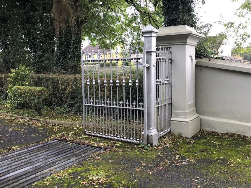
Volume 3, Chapter 12: Cultural Heritage

        ▪      EPA’s Advice Notes on Current Practice (in the preparation of Environmental Impact Statements) (EPA
               2003);
        ▪      National Roads Authority (NRA, now Transport Infrastructure Ireland) Guidelines for the Assessment of
               Architectural Heritage Impacts of National Road Schemes (NRA 2005a);
        ▪      NRA Guidelines for the Assessment of Archaeological Heritage Impacts of National Road Schemes (NRA
               2005b).
Overall planning policy for heritage in County Cork is set out in Volume 1, Chapter 12 of the Cork County
Development Plan (CDP) 2014 (see 12.5.2) and planning policy for heritage in County Limerick is set out in
Volume 1, Chapter 7 of the Limerick CDP 2010 (see 12.5.3).

12.4               Baseline data gathering
As outlined above, for the purpose of this assessment a broad study area was defined which extended 2km around
the Dublin–Cork Railway Line between Knocklong West and Ballybeg to the south of Buttevant in order to gain an
understanding of the archaeological and historical context of the proposed Project. For the impact assessments,
individual study areas were defined for each crossing extending c.500m beyond the footprint of the proposed
Project in which previously recorded cultural heritage assets were identified using the sources outlined below. The
footprint of the proposed Project was defined as the earthworks, carriageway, bridges, structures, compounds and
lands made available as shown in Volume 4). The assessment then considered the likely effects of the proposed
Project on each of the identified cultural heritage receptors. The key sources of information consulted during the
baseline desktop research are listed below:
              i.     RMP – statutory list of protected places and monuments, with accompanying constraints maps for
                     County Cork (published in 1998) and County Limerick (published in 1997);
             ii.     SMR – online database with information on sites and monuments accessed via the HEV; 2
            iii.     Lists of National Monuments in State Care: Ownership and Guardianship for County Cork and County
                     Limerick (published in 2009);
            iv.      List of Preservation Orders held by the NMS, published in 2019;
             v.      Previous studies including archaeological assessments of six of the seven crossings (XC187–XC209
                     and XC212–XC219), as well as a built heritage survey for XC219, carried out by Valerie J. Keeley (VJK)
                     (Flynn 2010; Flynn 2011; Goodbody 2012);
            vi.      Other previous archaeological investigations as recorded by the Database of Irish Excavation Reports
                     (DIER)3 and TII Digital Heritage Collection available online in the Digital Repository of Ireland (DRI); 4
            vii.     Stray finds: National Museum of Ireland (NMI) online finds database made available by the Heritage
                     Council;5
         viii.       Records of Protected Structures for Cork and Limerick as outlined in the Cork County Development
                     Plan 2014–20206 and Limerick County Development Plan 2010–2016;7, 8
            ix.      NIAH;9

2   Available at: http://webgis.archaeology.ie/historicenvironment/
3
    Available at: https://excavations.ie
4   Available at: https://repository.dri.ie/catalog/v6936m966
5   Available at: https://heritagemaps.ie/WebApps/HeritageMaps/ [partial]
6   Available at: http://corkcocodevplan.com/
7   Available at: https://www.limerick.ie/council/services/planning-and-property/development-plans/county-development-plan
8   Note: The Limerick County Development Plan 2010-2016 will continue to have effect until a new Development Plan for the county is prepared
9
    Available at: https://www.buildingsofireland.ie

                                                                                                                                                3
Volume 3, Chapter 12: Cultural Heritage

             x.       Cartography: Historical Ordnance Survey maps via OSI’s public viewer (first-edition six-inch map for
                      Cork published 1845; first-edition six-inch map for Limerick published 1844; first-edition 25-inch
                      map for Cork surveyed 1896–1904; first-edition 25-inch map for Limerick surveyed 1897–1900); 10
            xi.       Aerial photography: Google Earth and Digital Globe via the HEV and orthophotographs via OSI’s
                      public viewer;
            xii.      National Folklore Collection UCD Schools Collection;11
         xiii.        Placenames Database of Ireland;12
         xiv.         Various historical and archaeological literature as listed in the References.
The data collected through the initial desktop research was presented to the environmental assessment and
design teams (Smith 2019; Volume 5, Appendix 12D) and then verified and supplemented through field surveys
and other archaeological investigations as set out in the EIA Screening and Scoping Report.
The initial fieldwork, which took place between 9th and 11th October 2019, comprised a windshield survey and
site-specific walkover inspections. The windshield survey gave the assessors an initial familiarity with the areas
involved and the surrounding landscapes, as well as locating previously recorded monuments and built heritage
assets. The walkover inspections involved the assessors walking the lengths and breadths of each site to verify the
extent and condition of previously recorded monuments; supplement the information gathered during the
desktop research; locate any previously unrecorded sites, features or areas of potential cultural heritage
significance requiring further investigation; and inform the impact assessments.
Geophysical surveys to investigate for potential unrecorded subsurface archaeology were carried out over three
phases during 2020:
        •          In February 2020, AMS conducted geophysical surveys at XC211 Newtown (in the immediate vicinity of
                   ringfort AY023; Volume 5, Appendix 12E) and at XC215 Shinanagh in the field surrounding Imphrick
                   Church and graveyard (AY029 and AY030; Volume 5, Appendix 12F);
        •          In June 2020, Target Archaeological Geophysics (TAG) conducted further geophysical surveys on behalf
                   of AMS at XC211 Newtown (to the south of ringfort AY023) and along the proposed route at XC215
                   Shinanagh in the fields to the north of Imphrick Church and graveyard (AY029 and AY030) (Volume 5,
                   Appendix 12G);
        •          In November/December 2020, Archaeological Consultancy Services Unit (ACSU) carried out geophysical
                   surveys at XC201 Thomastown, XC212 Ballycoskery, XC219 Buttevant and along an alternative route for
                   XC215 Shinanagh in the townland of Ballynageragh to the west of Imphrick Church (Volume 5,
                   Appendix 12H).
Targeted archaeological test excavations were carried out by ACSU in November 2020 at XC211 Newtown
(Volume 5, Appendix 12I) and XC215 Shinanagh (Volume 5, Appendix 12J). The purpose of these investigations
was to determine the nature of the geophysical anomalies as either archaeological or non-archaeological. A
Topographical Survey was also carried out by ACSU at XC215 Shinanagh surrounding Imphrick Church and
graveyard (AY029 and AY030) as part of this work (Volume 5, Appendix 12K).
In addition, archaeological monitoring of geotechnical investigations at XC201 Thomastown, XC211 Newtown,
XC212 Ballycoskery, XC215 Imphrick and XC219 Buttevant was carried out by TVAS Ireland Ltd from February to
July 2020 (Volume 5, Appendix 12L).
The geophysical surveys, archaeological test excavations and monitoring outlined above were carried out in
consultation with and under licence from the National Monuments Service (NMS).

10   Available at: http://map.geohive.ie/
11   Available at: https://www.duchas.ie/en
12
     Available at: https://www.logainm.ie/en/

                                                                                                                             4
Volume 3, Chapter 12: Cultural Heritage
12.4.1 Consultation
During the preparation of this assessment, consultation was undertaken with the NMS (DHLGH) and Officers of
Cork and Limerick County Councils as set out in Table 12. 1 below. Volume 2, Chapter 1: Introduction includes a
summary of the consultation that was undertaken for the proposed Project.
Table 12. 1: Consultation
Consultee Comment Response
Department of (30th September 2019) This chapter assesses the likely impact and
Culture, Heritage This commented that “The information provided was not significance of effect on cultural heritage as a result
and the sufficiently detailed to allow for a full assessment of the of the construction and operation of the proposed
Gaeltacht archaeological implications of this proposal, however the Project.
Department wishes to advise that as part of the compilation of Geophysical Survey Reports were prepared by AMS
an Environmental Impact Statement (EIS) it is recommended that for XC211 Newtown and XC215 Shinanagh. Further
you retain the services of a suitably qualified Consultant test trenching and geophysical surveys were
Archaeologist to carry out a Cultural Heritage and undertaken by ACSU Ltd.
Archaeological Impact Assessment (CHAIA) of the proposed The consultation with NMS through the course of the
development. In this regard the Department awaits the results of proposed Project has shaped the scope of the
the CHAIA before commenting further.“ geophysical surveys and text trenching undertaken.
18th June 2020 a teleconference was held with NMS. The mitigation proposed by NMS has been included
NMS issued an advice note/Archaeological Mitigation Strategy within this chapter.
on 6th July 2020 (Volume 5, Appendix 12B)
31st July 2020 a teleconference was held with NMS.
6th January 2021 a teleconference meeting held with NMS.
2nd February 2021 NMS issued an updated Archaeological
Mitigation Strategy after review of all geophysical surveys and
test trenching information (Volume 5, Appendix 12C)
Cork County Mary Sleeman (Heritage Unit), 30th September 2019 The mitigation as part of this chapter includes a
Council Heritage Sets out that of the five sites in Cork three are modern level requirement for photographic records to be taken
Unit crossings and there is no issue with replacement but where relevant.
recommends photographic record. Requires clarity on proposed
solution for XC212 Ballycoskery and XC211 Newtown. States
that XC211 Newtown is a fine stone arched bridge and
clarification sought regarding proposed works.
Mary Sleeman (Heritage Unit), 2nd October 2019
States that if the level crossings XC211 and XC212 Newtown and
Ballycoskery are like the other level crossings (modern) “there is
no heritage issue with replacement”.
Limerick City & Thomas O’Neill (Heritage Officer) dated 10th January 2020. This chapter has assessed the likely impact and
County Council Under cultural heritage the fact that line itself dating from the significance of effects on cultural heritage as a result
19th Century may have architectural, historical, archaeological, of the construction and operation of the proposed
artistic, cultural, scientific, social or technical interest echoes the Project
protected structure legislation- this should mean that these
aspects should be adequately covered in the EIAR.
12.4.2 Assessment of Importance
National monuments legislation does not differentiate between archaeological sites on the basis of importance
apart from the special recognition of National Monuments, Recorded Monuments and Registered Monuments as
defined in the National Monuments Acts 1930 to 2014. For the purpose of the assessment, an evaluation of the
importance of each archaeological site within the study area was made where possible on a four-point scale of
Negligible, Low, Medium or High. These assessments were based on professional judgment and experience, guided
by the criteria set out in Appendix 2 of the NRA Guidelines (NRA 2005b, 51). Where the nature and significance of
potential archaeological features have yet to be determined, the importance of the site has been rated as
‘Unknown’. For architectural heritage, the rating system of Local, Regional, National, International or Record Only
was used in accordance with the NRA architectural heritage guidelines (NRA 2005a, 31).
5Volume 3, Chapter 12: Cultural Heritage
12.4.3 Impact Assessment
The impact assessment followed the generic EIA method described in Chapter 4 EIA Process and Method, using
the impact assessment matrix provided on p.53 of the EPA’s draft Guidelines on the Information to be contained
in Environmental Impact Assessment Reports (EPA 2017) for archaeology and p.32 of the NRA’s Guidelines for
the Assessment of Architectural Heritage Impacts of National Road Schemes for architectural heritage (NRA
2005a).
12.5 Baseline Environment
12.5.1 Archaeological and Historical Context of the Overall proposed Project
The baseline scenario for each of the crossings is summarised in Sections 12.5.4 to 12.5.9 below. Here we outline
the archaeological and historical context of the proposed Project.
Over 120 summary reports on test excavations or archaeological monitoring conducted in and around the
development are reported in the DIER.13 Of the investigations where archaeological features, finds and deposits
were recorded, a total of 1 (no.) Neolithic, 9 (no.) probable Bronze Age, 1 (no.) possible Iron Age, 3 (no.) Early
Medieval, 32 (no.) Medieval and probable medieval, 1 (no.) Late Medieval/ Early Modern, 13 (no.) Post Medieval,
5 (no.) modern and 6 (no.) undated entries are listed. The Bord Gais Éireann ‘Pipeline to the West’ DIER listings
account for 16 (no.) of the total number of investigations listed, of which just 4 (no.) were of no archaeological
significance. Medieval archaeology is represented chiefly by investigations in the medieval towns of Buttevant and
Kilmallock, although it is worth noting that more than 20 of the almost 30 (no.) investigations in Buttevant and
17 of the 47 (no.) recorded investigations at Kilmallock were of no archaeological significance. Investigations that
did record archaeological or potential archaeological features or deposits are included in the overview presented
below where pertinent. Other significant archaeological work in this area includes the Discovery Programme’s
Ballyhoura Hills Project which collated archaeological surveys and aerial photographs to identify sites of potential
prehistoric date in the Ballyhoura Hills.
The National Museum of Ireland (NMI) database (incomplete) of finds hosted on the Heritage Council’s Heritage
Map Viewer (HMV)14 records just three finds locations within the Study Area, including undated cremated bone
from Sorrel townland (HMV/NMI online database A/110/78); a small bronze axehead from Garrynderk South
townland (HMV/NMI online database 1935:507) and two sherds of ceramics (one green glazed potsherd, one
stoneware potsherd) from Kilmallock Town (NMI/HMV reg. No 1986: 13, 14).
Prehistoric Period (c. 7000BC–AD400)
Mesolithic (7000–4000 BC)
Evidence for Mesolithic activity (7000–4000 BC) in Ireland tends to be concentrated around or in close proximity
to water and has now been identified throughout the island of Ireland. Traditionally accepted as being hunter-
gatherers, the material culture of the earliest Mesolithic inhabitants of the country is generally represented by
composite microlith tools including needle points, flake axes and polished stone axes. A single radiocarbon dated
sample from an excavation at Mitchelstowndown East immediately adjacent to the Study Area has yielded a
Mesolithic date, but no diagnostic finds were recovered in association with this site. A re-examination of the lithic
assemblage from an excavated ring-barrow at Rathjordan (c.12.5km from Knocklong at the northern limit of the
Study Area) has identified microliths of the early Mesolithic period (Woodman 1986). In the wider vicinity of Co.
Limerick, evidence for Mesolithic activity has been found from two phases of excavations c.20km to the northeast
of the Study Area at Killuragh Cave in 1993 and 1996. These excavations produced diagnostic early Mesolithic
13 https://excavations.ie/
14
https://www.heritagemaps.ie/
6Volume 3, Chapter 12: Cultural Heritage
flint blades and microliths, as well as human remains. The final stage of the Mesolithic at Killuragh is represented
by a possible flake fragment from a large butt-trimmed lithic and by radiocarbon dated samples. At Hermitage,
Co. Limerick (c. 30km to the northwest of the Study Area), a Mesolithic cremation burial (SMR LI001-010001) –
the earliest known burial in Ireland – was recorded. The burial was accompanied by a stone adze and a large butt-
trimmed flake. Discoveries such as these suggest that the relative paucity of sites and material culture recorded
for this part of the country may be readdressed with time.
Neolithic (4000–2500BC)
The Neolithic period (4000–2500BC) is typically associated with Ireland’s first farmers; the century between
c.3800 – 3700BC saw a period of rapid expansion across the country, with the archaeological imprint of
rectangular houses representing a common settlement feature of this period. The Study Area is situated c.12km
on the southeastern periphery of Lough Gur where the Discovery Programme’s North Munster Project, led by Eoin
Grogan, has examined the prehistory of this part of Limerick and has identified a Neolithic core of activity around
Rockbarton-Caherguillamore and Knockainy and in the valley of the Camoge River. A total of 280 (no.) stone axes
are recorded as having been discovered from this limited area, and an expansion of Neolithic settlement radiating
from this core area along the river and stream valleys is postulated. Within the Study Area, the DIER records the
summary excavation of a Neolithic house in Pepperhill townland, and the Neolithic house at Tankardstown South
excavated as part of the Bord Gáis Éireann (BGE) works was found less than 5km to the north of Fantstown. At
Lough Gur, c.12km from the Study Area, a total of 4 (no.) excavated Neolithic houses are listed on the HEV. From
Killuragh Cave, the Neolithic period is represented by two radiocarbon dates and two hollow scrapers.
The Neolithic period saw the construction of a variety of imposing megalithic tombs (court, passage, portal and
wedge) which imply the presence of complex and ordered farming communities in existence at that time. While a
chronology in terms of tomb types has been suggested (with court tombs being the earliest and wedge tombs
being the latest), it would appear that a chronological overlap in their construction and use-history is evident.
Local topography and associated settlements were potentially a factor in the location choice for the construction
of these monuments. Grogan suggests that the widespread nature of these tombs throughout North Munster
represents strong regional cohesion as well as evidence for the expansion of settlement in the region. Within the
Study Area, an unclassified cairn (CO024-056001) surrounding a wedge tomb (CO024-05602) in Kilmaclenine
townland is recorded as having been ‘ransacked’ and heavily quarried in the early 19th century. A second
megalithic structure (LI047-022021) is located immediately west of Kilmallock in Ash Hill townland. Previous
archaeological investigations in the vicinity of this monument identified features for which no diagnostic dating
evidence was recovered; these could be of prehistoric or later date.
Three ‘mounds’ of possible prehistoric origin are recorded within the Study Area, including one in Lackaroe
(CO017-033) near Buttevant. Local oral tradition records its name as Knockane-na-m-buachaillidhe; that is, 'the
mound or hillock of the boys'. As with court tomb CO024-05602, this mound had been plundered in antiquity.
Limited descriptions of a low oval mound (CO016-138) in Rathclare townland are recorded on the HEV, and it
remains undated at present. No information on mound LI047-046 (AY011) is recorded on the HEV; however, the
proposed development at crossing XC201 Thomastown will not impact on the setting of this feature.
Field systems comprising an arrangement of fields which appear to form a coherent whole may have their origins
in the Neolithic period and provide important information on prehistoric spatial arrangement and land use
patterns. The Céide Fields on the northwest Atlantic coast are arguably the best preserved of this feature type in
Ireland, although traces of similar relict prehistoric landscapes lie fossilised throughout the modern landscape.
However, in a monument rich landscape such as that of east Limerick, where early ringforts may also sit within
often fragmented but related field systems, it is difficult to chronologically tease apart this multi-layered site-type,
or to accurately assign them to an appropriate period. This may be the case in such examples as the field system
(CO017-122) in Rathclare townland, elements of which may be associated with a circular enclosure (CO017-131).
7Volume 3, Chapter 12: Cultural Heritage
No HEV detail was available on the nature or extent of the field systems within the Study Area (LI040-106001,
LI040-113-, LI040-129-, LI040-137001- and LI040-100001), but it is possible that traces of relict prehistoric
field systems are represented here.
Bronze Age (2500–500BC)
The Bronze Age (2500–500BC) is typically associated with the introduction and development of metal technology
and the use of metal tools, with a distinct warrior elite class defined by high status weaponry appearing towards
the end of the period. Hoards of deliberately deposited high-status metal objects, as well as deliberate deposition
of human remains in wetland environments, is a recognised feature of the later Bronze Age. Copper mining in
Munster was a conducted as an industry, and routeways for the distribution of people and materials as well as
fording points on significant rivers also acted as a focus for settlement. Hillforts may have been constructed on
strategic points to command and protect these routeways. A significant number of Bronze Age settlement sites
and houses have been identified through archaeological investigations on large infrastructural and research
projects in North Munster, such as on the BGE Pipeline to the West, on the M8/N8 motorway and on the M7
motorway. The funerary traditions of the Bronze Age are varied, for which within this Study Area a distinct
concentration of barrows, particularly ring-barrows, is the typical representative site type. In addition, individual
cremation burials, cremation cemeteries and isolated burials are known. Gold working and master craftsmanship
are also a significant feature of Bronze Age Ireland, with sheet gold work being significant in the east Limerick area.
A single small bronze axe-head from Garrynderk South townland (HMV/NMI online database 1935:507) is
recorded for the Study Area, but in the wider area similar finds were deposited as votive offerings in lakes such as
at Lough Gur. A bronze sword and spearhead were recovered from Ballyroe townland, as well as a significant find
of amber from Kilmallock (ibid).
Regarding settlement sites, two possible Early Bronze Age structures as well as clusters of other possible Late
Neolithic and Bronze Age stakeholes, hearths and linear features were identified as part of archaeological
investigations in Creggane, Buttevant. A wide range of lithics including a stone axe, flint debitage, chert, flint tools
as well as pottery (possibly Bronze Age) was recovered from the excavations at this site. Two late Bronze Age
houses (LI039-072 and LI039-073) were excavated in Ballinacurra (Coshma By.) as part of the BGE pipeline; these
structures were small (measuring 3m and 2.34m in diameter) with limited artefactual evidence (a broken
thumbnail scraper and worked chert fragment) recovered from within the beam/slot trenches which defined the
perimeter of each structure. No evidence for internal or roof structural supports was identified in the excavations,
and although often providing the diagnostic dating evidence for domestic structures of this period, there was no
pottery recovered here. Enclosing elements surrounding the houses at Ballinacurra were also identified; these
habitation enclosures are often found in association with middle to late Bronze Age settlement sites.
At Doonmoon, excavations as part of the BGE Pipeline to the West identified at a ring-barrow and associated pits
which yielded a Beaker ceramic assemblage of Early Bronze Age date. A possible kiln (LI040-108002) for the
production of these Beaker vessels was also identified as part of this investigation. Other excavations and
investigations within the Study Area identified cremation pits and cemeteries of Bronze Age date, including in
Ballinacurra townland, while cremation burials (LI040-138) with a distinct clay capping which sealed the deposited
remains of human bone mixed with pyre debris were excavated by Margaret Gowen in Mitchelstowndown North.
At Rathgoggan South, a pit burial (CO003-016) was excavated in 1986 during construction of the Bruff to Mallow
gas pipeline. These are likely to represent middle to late Bronze Age burials, where burial rites often include the
deposition of burnt and unburnt bone, and burial of selected token elements of the cremated individual. Further
cremation burials within the Study Area include a burial represented by a broken mandible of an adult male at
Adamstown and the discovery of three Bronze Age cist burials (CO008-012001; CO008-01203 and CO008-
01204) in Ballynaboola townland in 1978; traces of the limestone stone cist lining as well as cremated bone were
identified in association with these.
8Volume 3, Chapter 12: Cultural Heritage
Visible and extant funerary monuments of the Bronze Age/Iron Age in the Study Area are represented by a total
of 141 (no.) ring barrows and 3 (no.) unclassified barrows recorded on the Sites and Monuments Record (SMR).
Ring barrows comprise a low mounded area with enclosing ditch and/or bank(s), and are generally dated to
between c. 2400BC to AD400. These sites may or may not contain human remains. While over 900 (no.) barrows
are recorded in the county of Limerick alone, the townland of Elton within the Study Area is of particular
significance having a total of 68 (no.) ring barrows recorded. Excavations in the vicinity of these barrows identified
pits, stakeholes, possible and prehistoric ditches as well as flint artefacts and fragments of ceramic vessels.
Other monuments often associated with Bronze Age funerary traditions include standing stones which were
originally set upright in the ground, standing up to 6m high. These megaliths may also have served as route-
markers in the landscape or defined the boundaries of territories and land ownership. Although it is generally
accepted that the use-history of these features overlaps with the chronological timeframe for barrows, some
standing stones may date to the early medieval period. Within the Study Area, a total of 14 (no.) standing stones
are recorded on the HEV, with 2 being in Rathclare and Grange East (Orrery and Kilmore By.) townlands, and one
each in Ardkilmartin, Ballybeg East, Ballynaboola, Boherascrub East, Bregoge, Grange West (Orrery and Kilmore
By.), Lisballyhay, Rathgoggan South, Spital (Orrery and Kilmore By.) and Velvetstown townlands. Archaeological
investigations around the base of a standing stone as part of the BGE pipeline development in Ballygrennan
townland just beyond the limits of the Study Area yielded a small yellow glass bead, but no evidence for a burial.
An earthwork is recorded adjacent to a standing stone (CO017-006001) in Velvetstown which may be prehistoric
in date (see earthworks below).
There are no recorded large enclosure sites (with an average diameter of more than 70m) within the Study Area;
however, c.12km to the northwest of Kilmallock three examples are known (LI031-092, LI031-097 and LI032-
188). These large enclosures may represent strategic enclosures designed to defend prehistoric routeways
through this part of Limerick and may be of Bronze Age date. The enclosures may be contemporary with the
funerary monuments, but without archaeological excavation this cannot be definitively proven. The DIER listings
for the Study Area also record archaeological works taking place in the vicinity of a large enclosure site.
There is a large number of enclosure sites (123 (no.) enclosures with an average diameter of less than 70m)
recorded in the SMR/HEV within the overall Study Area. These sites may relate to habitation or funerary ritual sites
of the Bronze Age, although it is also possible that some are monuments of different archaeological periods. The
enclosure sites within the Study Area include a notable concentration in Knocklong West townland.
Fulachta Fia are amongst the most common site types in Ireland and are characterised by a mound or mounds of
heat-shattered stone discarded from the process of heating water in a subsoil-cut trough. Generally found in low-
lying ground where the water table is close to the surface, the often wood-lined troughs filled naturally with water.
Closely resembling fulachtaí are burnt mounds/spreads and hearths, which may or may not include a pit in place
of a water-filled trough; these are often interpreted as roasting sites. The use/function of fulachtaí fia and similar
site-types were many and varied, from cooking to bathing places to brewing sites and sweat houses; some are
undoubtedly associated with metal working, dyeing and textile production, feasting, etc. A clearer indication of the
use-history of the fulachtaí fia/burnt mounds in this Study Area (27 recorded in 17 of the 121 (no.) townlands)
can only be derived from archaeological excavation. However, it is likely that additional fulachtaí are present and
are as yet undetected, especially in the more low-lying portions of the landscape.
Isolated features of possible Bronze Age date, but not forming part of any recognisable site-type, were excavated
at Ballinacurra, and a second site in the same townland produced evidence for pits containing burnt and unburnt
stone and animal bone in a fulacht-type stone and charcoal matrix. The excavator suggested a possible Bronze
Age or Iron Age date for these features.
9Volume 3, Chapter 12: Cultural Heritage
Iron Age (500BC–AD400)
Regarding Iron Age (500BC–AD400) activity in Ireland, much archaeological attention for this period was
previously focused on the ‘royal sites’ of the Iron Age, and this has skewed the archaeological record for the period.
No houses of Iron Age date are recorded on the SMR for either Limerick or Cork counties, and diagnostic artefacts
dating to the Iron Age are not commonly found on excavations. However, archaeological investigations in the wider
Munster area on recent large infrastructural projects have identified a number of Iron Age houses and settlement
sites. These sites often comprise sparse and isolated features, and a comprehensive picture of the wider settlement
context for them is consequently difficult to discern. There is a possibility that some of the funerary monuments
ascribed to the Bronze Age (see above) may more accurately belong to this period. Similarly, some of the generic
large ‘enclosures’ previously mentioned may represent hillforts or sites of Iron Age date. However, through the
archaeological investigations of the past two decades, it is possible to discern an emerging and more holistic
picture of the Iron Age in Munster.
Early Medieval Period
A total of 62 ringforts are recorded in 35 townlands within the Study Area; all are of ringfort-rath type. These
ringforts represent the defended but dispersed homesteads of relatively wealthy farmers and are generally dated
to the early medieval period (AD400–1100), though some remained in use until much later. Stout (2015, 73)
suggests that of the c.60,000 ringforts in Ireland, most of these were occupied between the early seventh and
ninth centuries AD. Ringforts are also representative of a predominantly rural-based cattle economy within a
pastoral landscape. There is no significant evidence to suggest that clusters of houses or settlements occur outside
these ringforts, although alongside many of the ringforts outlying subsurface archaeological remains (e.g.,
trackways, field systems and souterrains) also have the potential to occur, as do ringfort sites with no surface
expression. It is not unusual to find kilns or industrial working areas located beyond the limits of the ringfort
enclosure, and although no such examples are recorded within the 2km Study Area, it is likely that some survive
below the present ground levels. Archaeological investigative works in the vicinity of ringforts where no evidence
for archaeological features or deposits were identified include test excavations adjacent at the univallate Monaboy
Fort (LI023-089) in Ballysallagh townland; at ringfort (CO008-039 [AY022]) in Ballycoskery townland and 2
investigations at ringfort (CO025-007) in Ballymague. Other Early Medieval features investigated in previous
archaeological works within the Study Area include excavation of an Early Medieval ditch in Kilmallock.
Souterrains are subsurface stone features built for storage and/or defence, dating primarily to the Early Medieval
period. They are commonly, although not always, associated with ringforts, and within this Study Area a total of
10 souterrains are listed. Of these, 3 are not associated with a ringfort, including souterrain CO025-163 and an
infilled souterrain (CO025-169) in Ballybeg West townland. Another unenclosed 2-chambered souterrain
(CO024-063) in Grange East townland was excavated by Prof. M. J. O’Kelly in 1963. Of the 7 (no.) examples
associated with ringforts, souterrain CO024-054002 is located in the centre of ringfort (CO007-05401) in
Ballynadrideen townland. Although no visible trace of souterrain CO024-136002 exists, it is recorded as being in
the centre of ringfort CO024-136001 in Ballyvorisheen townland. Similarly, no surface trace survives of a partially
collapsed souterrain CO017-030002 in Rathclare townland within ringfort CO017-03001. Nineteenth-century
antiquarian accounts of the discovery of a souterrain (CO024-201) within ringfort (CO024-103) in Copsetown
survive. Within a levelled ringfort, an oval hollow interpreted as the remains of a souterrain (CO024-199) are
recorded in Kilmaclenine townland, and in Tinnascart townland within ringfort CO016-194, a curvilinear
depression is interpreted as being the remains of a collapsed chamber and passage of souterrain CO016-255.
None of the field systems recorded within the Study Area appear to relate or to be associated with ringforts.
However, the townland boundary system in the modern landscape frequently reflects boundaries established
before and after the Anglo-Norman period, and many reflect ancient territorial or landownership boundaries;
indeed, many townlands maintain names which reflect their Gaelic Irish origin. Within the Study Area, a total of 10
10You can also read