King's Island Flood Relief Scheme EIAR Scoping Report - King's Island Flood Relief Scheme
←
→
Page content transcription
If your browser does not render page correctly, please read the page content below
King's Island Flood Relief
Scheme
EIAR Scoping Report
December 2018
JBA Project Manager
Declan White
24 Grove Island
Corbally
Limerick
Ireland

Revision History
   Revision Ref / Date Issued              Amendments                              Issued to
   Draft V1.0/ 30/01/2018                  Initial Issue                           Arup
   Draft V1.1/ 10/04/2018                  Second Issue                            Arup
   Draft 2.0 / 03/05/2018                  Public Consultation                     Arup
                                           Revised date for comments on            Statutory
   V3.0/ 21/12/2018
                                           Scoping Report                          Consultees/Stakeholders

Contract
This report describes work commissioned by Limerick City & County Council, on behalf of JBA,
The Limerick City & County Council representative for this work is Mr. Kieran O'Gorman.
Declan Egan, Bernadette O'Connell and Catalina Herrera of JBA Consulting carried out this
work.
Prepared by .................................................. Catalina Herrera BSc MSc
                                                      Environmental Scientist

Reviewed by ................................................. Bernadette O'Connell BA(Hons) MSc CMLI
                                                      Principal Environmental Consultant

                                                      Declan Egan BSc. MSc. CSci. CEnv. CWEM
                                                      MCIWEM MCIWM

                                                      Technical Director Environment

Purpose
This document has been prepared as a Final Report for Limerick City & County Council. JBA
Consulting accepts no responsibility or liability for any use that is made of this document other
than by the Client for the purposes for which it was originally commissioned and prepared.
JBA Consulting has no liability regarding the use of this report except to Limerick City & County
Council.

Copyright
© JBA Consulting Engineers and Scientists Ltd 2018

Carbon Footprint
A printed copy of the main text in this document will result in a carbon footprint of 198g if 100%
post-consumer recycled paper is used and 252g if primary-source paper is used. These figures
assume the report is printed in black and white on A4 paper and in duplex.
JBA is aiming to reduce its per capita carbon emissions.
 2015s3353-Kings Island - EIAR Scoping Report V3.0
Executive Summary
This Scoping Report forms the first stage in the preparation of the Environmental Impact
Assessment Report (EIAR) for the King's Island Flood Relief Scheme (FRS) in Limerick City.
The Scoping Report introduces the proposed development, defines the location and extent of
works, identifies the key environmental issues and receptors in the vicinity, the potential impacts
of the proposal, and identifies the likely environmental studies that are required to inform the
EIAR.
King’s Island lies in the heart of Limerick City and is surrounded by the waters of the River
Shannon and the Abbey River. Both rivers are tidal at this location and the island is historically
susceptible to both tidal and fluvial flood risk. King’s Island and surrounding areas were badly
flooded in early 2014 when there was an extremely high tide that overtopped the embankments
around the Island and caused them to fail. Major improvements to the flood defences are
required to try to prevent re-occurrences of such flood events.
JBA Consulting/ARUP, were commissioned by Limerick City & County Council (LCCC) to
provide engineering services for the King's Island Flood Relief Scheme (the Scheme). This
scheme will be designed to provide protection to properties in the study area from the 1 in 200-
year tidal flood event (0.5% AEP event).
The overarching objective of the project is:
“…to assess, develop and design an appropriate viable, cost-effective and sustainable flood
relief scheme which aims to minimise risk to human beings, the existing community, social
amenity, environment and landscape character.”
The Scoping Report conclusion provides a summary of all environmental aspects which require
to be considered in the EIAR and Natura Impact Statement (NIS) for the FRS preferred option
in terms of potential impacts during construction and operational phases.
Consultation with the public, stakeholders, statutory consultees and non-statutory organisations
is being undertaken, to ensure input from all interested parties from the earliest stages of the
EIAR and NIS preparation. The completed EIAR and NIS will be submitted to An Bord Pleanála
as part of the formal planning application process.

 2015s3353-Kings Island - EIAR Scoping Report V3.0
Contents
Executive Summary.......................................................................................................... ii
1 Introduction .......................................................................................................... 1
1.1 Purpose of this Report ........................................................................................... 1
1.2 Project Background ............................................................................................... 1
1.3 Study Area ............................................................................................................. 2
1.4 Proposed Development ......................................................................................... 3
2 Regulatory Context and Planning History ........................................................ 7
2.1 Regulatory Context and Planning History.............................................................. 7
3 The Consultation Process .................................................................................. 10
3.1 Requirements for Consultation .............................................................................. 10
3.2 Ongoing Communication ....................................................................................... 10
3.3 Public Consultation Events .................................................................................... 11
3.4 Formal Scoping Consultation ................................................................................ 13
4 Alternatives and Preferred Option ..................................................................... 14
4.1 Initial alternatives considered and screening of viable measures ......................... 14
4.2 Emerging Preferred Option .................................................................................... 16
5 Scoping of EIAR ................................................................................................... 24
5.1 Introduction to Environmental Factors ................................................................... 24
5.2 Population and Human Heath ............................................................................... 24
5.3 Material Assets ...................................................................................................... 25
5.4 Roads and Traffic .................................................................................................. 26
5.5 Water Quality ......................................................................................................... 26
5.6 Archaeology and Cultural Heritage ........................................................................ 28
5.7 Biodiversity ............................................................................................................ 29
5.8 Landscape and Visual ........................................................................................... 33
5.9 Geology and Soil ................................................................................................... 34
5.10 Air and Noise ......................................................................................................... 35
5.11 Climate Change ..................................................................................................... 37
5.12 Interaction between environmental aspects .......................................................... 38
5.13 Cumulative impacts ............................................................................................... 38
5.14 Schedule of Environmental Commitments ............................................................ 38
6 Conclusion ........................................................................................................... 39
A Response to consultation on Scoping Document ........................................... 42
List of Figures
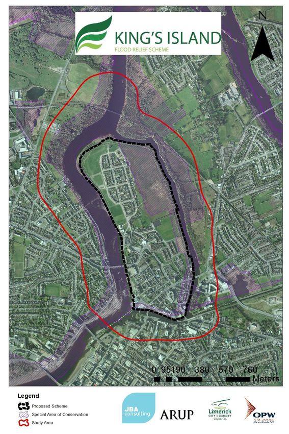
Figure 1-1. Location Plan and Site Context ........................................................................ 4
Figure 1-2. Existing Situation .............................................................................................. 5
Figure 1-3. Flood Cells and sub areas ............................................................................... 6
Figure 4-1: Replacement capping and railing at Verdant Place ......................................... 17
Figure 4-2: Proposed wall behind crèche ........................................................................... 17
Figure 4-3 - Conceptual design showing softening of embankment slope and pedestrian
access ............................................................................................................... 18
Figure 4-4 - Embankment and wall alignment at Star Rovers FC and Athlunkard Villa
FC ...................................................................................................................... 19
Figure 4-5: Typical section through the road, steps and wall at Sir Harry's Mall................ 20
2015s3353-Kings Island - EIAR Scoping Report V3.0
Figure 4-6: Plan of Areas A7-B1 around Absolute Hotel .................................................... 20
Figure 4-7 - Typical section through piled concrete wall .................................................... 21
Figure 4-8 - Proposed George's Quay Direct Defences ..................................................... 22
Figure 4-9 - Proposed Direct Defences and public walkway around Court House ............ 23

List of Tables
Table 3-1: King's Island FRS Communication and Consultation Approaches ................... 10
Table 4-1: Potential Flood Relief Options .......................................................................... 16
Table 4-2. Summary of preferred scheme option ............................................................... 16
Table 6-1. Summary of the scoping assessment findings .................................................. 39

 2015s3353-Kings Island - EIAR Scoping Report V3.0
Abbreviations
      AA                     Appropriate Assessment

      ACA                    Architectural Conservation Area

      CEMP                   Construction Environment Management Plan

      CFRAM                  Catchment-Based Flood Risk Assessment and Management

      DAHRRGA                Department of Arts, Heritage, Regional, Rural, and Gaeltacht Affairs

      DECLG                  Department of Environment, Community and Local Government

      DHPLG                  Department of Housing, Planning and Local Government (Formerly
                             DECLG)
      EEA                    European Environment Agency

      EIAR                   Environmental Impact Assessment Report

      EPA                    Environmental Protection Agency

      ESB                    Electricity Supply Board

      EU                     European Union

      FRMP                   Flood Risk Management Plan

      GSI                    Geological Survey Ireland

      IFA                    Irish Farmers Association

      IFI                    Inland Fisheries Ireland

      INFF                   Irish National Flood Forum

      IPCC                   Intergovernmental Panel on Climate Change

      IROPI                  Imperative Reasons of Overriding Public Interest

      LAP                    Local Area Plan

      LULC                   Land Use and Land Cover

      MCA                    Multi-Criteria Analysis

      NCCAF                  National Climate Change Adaptation Framework

      NFM                    Natural Flood Management

      NHA                    Natural Heritage Area

      NI                     Northern Ireland

      NIAH                   National Inventory of Architectural Heritage
                             Natura Impact Statement
      NIS

      NMI                    National Museum of Ireland

      NMS                    National Monuments Service

      NIG                    National Implementation Group

      NPWS                   National Parks and Wildlife Service

      OPW                    Office of Public Works

      PCD                    Public Consultation day

    2015s3353-Kings Island - EIAR Scoping Report V3.0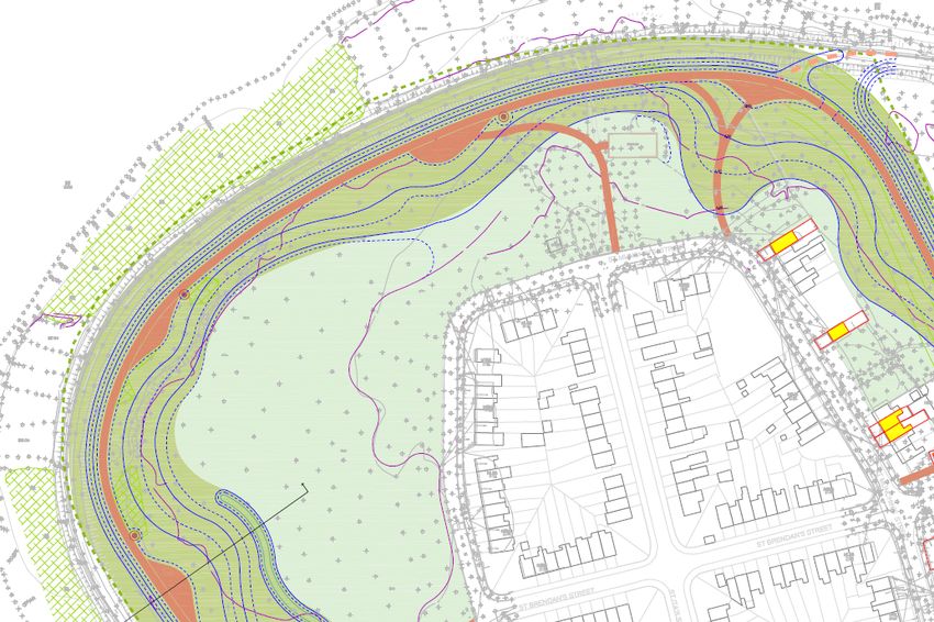
RBD                    River Basin District

  RBMP                   River Basin Management Plan

  RPG                    Regional Planning Group

  SAC                    Special Area of Conservation

  SEA                    Strategic Environmental Assessment

  SFRA                   Strategic Flood Risk Assessment

  SI                     Statutory Instrument

  SMR                    Sites and Monuments Records

  SPA                    Special Protection Area

  WFD                    Water Framework Directive

  WMU                    Water Management Unit

  WTW                    Water Treatment Works

  WWTW                   Waste Water Treatment Works

  ZAP                    Zones of Archaeological Potential

2015s3353-Kings Island - EIAR Scoping Report V3.0
1       Introduction
1.1     Purpose of this Report
        This Scoping Report forms the first stage in the preparation of the Environmental Impact
        Assessment Report (EIAR) for the King's Island Flood Relief Scheme (FRS) in Limerick City. (See
        Figure 1-1) The Scoping Report introduces the proposed development, defines the location and
        extent of works, identifies the key environmental issues and receptors in the vicinity, the potential
        impacts of the proposal, and identifies the likely environmental studies that are required to inform
        the full EIAR.
        The information in this report is based on:
            •    Information gathered during earlier stages of the project including the Constraints and
                 Options stages;
            •    Existing environmental data bases, reports and mapping; and
            •    Consultation with stakeholders and the public.

1.2     Project Background
        King’s Island lies in the heart of Limerick City and is surrounded by the River Shannon and the
        Abbey River as shown in Figure 1-1. Location Plan. Both rivers are tidal at this location and the
        island is historically susceptible to both tidal and fluvial flood risk. There is a history of flooding in
        King's Island, the most recent events recorded in 1999, 2002, 2009, and 2014 (Limerick City
        Council et al., 2013). Prolonged rainfall, spring tides, and storm surges have been the source of
        severe flooding (Limerick City Council et al., 2013). King’s Island and the surrounding area was
        badly flooded in early 2014 when there was an extremely high tide that overtopped the
        embankments around the Island and caused them to fail in one location.
        Much of the existing ground on the island is low-lying, particularly in the open spaces in the east
        of the island. The central spine of the island is generally quite elevated, with levels in the
        ‘Englishtown’ area (adjacent to the castle) being well in excess of the 0.5% AEP flood level, which
        is approximately 4.8mODElevations on the island range from 1.85mOD to 11mOD (E.Russell et
        al., 2018). Figure 1-2. Existing Situation shows where the existing embankments failed and were
        breached in the January 2014 flood event. Flood levels in this event were estimated to be
        approximately 4.55mOD and were high enough to induce significant structural damage to the
        existing embankments and necessitated the installation of remedial sheet piling. (E.Russell et al.,
        2018).
        Major improvements to the flood defences are required to try to prevent re-occurrences of such
        flood events. As such, JBA Consulting/ARUP, were commissioned by Limerick City & County
        Council (LCCC) to provide engineering services for the King's Island Flood Relief Scheme (the
        Scheme).
        The overarching objective of the project is to:
        “…to assess, develop and design an appropriate viable, cost-effective and sustainable flood relief
        scheme which aims to minimise risk to human beings, the existing community, social amenity,
        environment and landscape character.”
        The scheme is to be developed primarily to protect the affected areas against fluvial and tidal
        flooding. In addition, consideration will be given to the potential impact of any flood relief scheme
        on groundwater and pluvial flood risk. The target standard of protection (SOP) is the 0.5% AEP
        tidal event.
        This scheme will be designed to provide protection to properties in the study area from the 0.5%
        AEP tidal flood event, with a suitable freeboard allowance provided on both the hard and soft
        defences. An Options Assessment Report for King's Island is being prepared which provides
        technical detail of the flood protection options (it will be available at http://www.kingsislandfrs.ie/).

1.2.1   Stages of the Scheme
        There are five statutory phases of work in the completion of a FRS and the progression to one
        stage heavily depends on the outcome of the previous stage. The five stages of the project are as
        follows:
        2015s3353-Kings Island - EIAR Scoping Report V3.0                                                1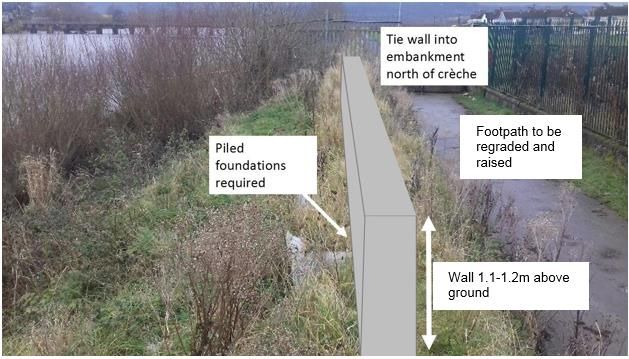
•    Stage I – Development of a number of flood defence options and the identification of a
                 Preferred Scheme;
            •    Stage II – Public Exhibition & Detailed Design;
            •    Stage III & IV – Tender & Construction; and
            •    Stage V – Project Close-Out (Handover to Client).

        This EIAR Scoping Report is produced as part of Stage I of the project. It follows on from work
        carried out to date. Supporting documents to this report include the following: (available at
        http://www.kingsislandfrs.ie/)
            •    Constraints Study for Flood Relief Scheme at King's Island, Limerick (December 2015);
                 and
            •    The King's Island FRS Options Assessment Report (preparation ongoing).

1.3     Study Area
        The study area for the proposed development shown in red on Figure 1-1 and includes the
        watercourses and environs adjacent to and surrounding King's Island. The area of the proposed
        development is shown by the black dotted line around Kings Island.

1.3.1   Site Location
        King's Island is located at the north-east of Limerick City Centre. It is a valuable asset to the city
        due to its historical importance, its ecological and archaeological significance, and its tourism
        potential. The island also contains a residential and community area with a large housing estate
        (St. Mary's Park) to the north and various terraces of houses to the south. The landscape of the
        island is urban with a low-lying area of wetland edging the north eastern part of the island.
        The urban area consists of a combination of residential, administrative, commercial, educational,
        ecclesiastical, and tourism elements. In terms of the built environment, the north of the island is
        predominantly residential and due to poor transportation connections, it is somewhat disconnected
        from the rest of the city. The southern part of the island has a wider range of land uses, retail
        opportunities, and includes King John's Castle and other historic buildings. King's Island has a
        community centre in the south-west region, two soccer pitches to the east of the Island and three
        educational facilities in the south of the island (one mixed primary school and two Gael
        Scoileanna). City Hall houses all the offices for Limerick City and County Council (LCCC) and
        other public administrative functions.

1.3.2   Surrounding Environment
        King's Island is situated between the River Shannon and the Abbey River putting the island at risk
        of fluvial and coastal flooding. The River Shannon is the largest river in Ireland, it rises in the
        Cuilcagh Mountains, at Shannon Pot, in Co. Cavan/Fermanagh and it flows in a southerly direction,
        discharging in the Shannon Estuary. At the north of King’s Island, the Shannon splits into two
        distinct waterbodies: the Shannon and the Abbey River. The Abbey River is a smaller watercourse
        that flows along the eastern and southern boundaries of the island before re-joining the Shannon
        adjacent to Merchant’s Quay and the Courthouse.
        The surrounding waterbodies and some eastern portions of the island are designated on ecological
        grounds as a Special Area of Conservation (SAC); as highlighted by the orange hatching. The
        SAC applicable to King’s Island is titled ‘Lower River Shannon’ (Site Code: 002165) and is of
        ecological interest as it contains habitats and species listed on Annexes I and II of the E.U. Habitats
        Directive. Also, of note, is the occurrence of invasive species such as Japanese Knotweed, Giant
        Hogweed, Himalayan Balsam, Buddleia, Winter Heliotrope on the island.
        King's Island has 28 structures listed for protection in the Records and Protected Structures (RPS).
        In addition, there are 10 structures currently recognised on the National Inventory of Architectural
        Heritage (NIAH) of Limerick City. There are currently no Architectural Conservation Area (ACA) in
        place in King's Island, however, the southwestern part of the King's Island has been included in
        the Area of Special Planning Designation (ASPD).

        2015s3353-Kings Island - EIAR Scoping Report V3.0                                              2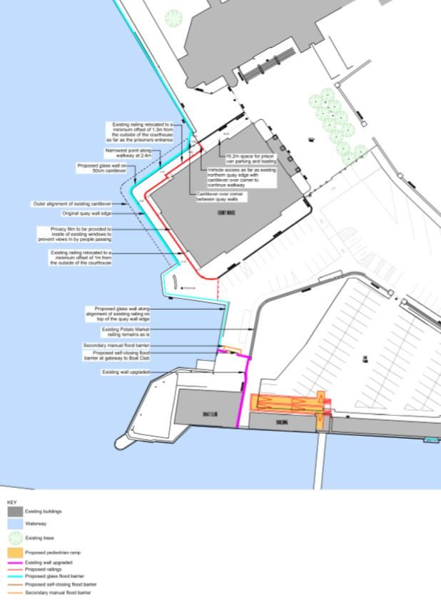
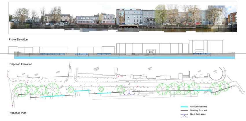
1.4   Proposed Development
      The proposed development is described in the project Options Assessment Report as the
      Emerging Preferred Option. It is a series of flood defences positioned around King's Island
      comprising both new and upgraded flood walls (incorporating glass panels in the urban areas) and
      embankments plus associated townscape improvements.
      The proposed development can be described further in terms of flood cells, which are defined on
      the basis of the extent of the 0.5% AEP flood event across the Kings Island study area. There are
      two flood cells, Flood Cells A and B as shown on Figure 1-3 Flood Cells and Sub areas.
      Flood Cell A - This is the more residential part of the island and currently has a level of flood
      protection primarily provided by embankments, although walls also contribute to the perimeter
      protection. One of the key constraints of this area is the Lower River Shannon Special Area of
      Conservation (SAC) and the proximity of its boundary relative to the proposed flood relief options.
      It includes the ten sub-areas A1-A10.
      Flood Cell B- This is the more commercial part of the study area. Where there is flood protection,
      it is in the form of quay walls. However, there is no defence provision around the Potato Market
      and civic buildings on Merchant's Quay. Relating new flood management measures to the existing
      built environment is the key constraint in the south of the island. It includes four sub-areas B1-B4.

      2015s3353-Kings Island - EIAR Scoping Report V3.0                                            3
Figure 1-1. Location Plan and Site Context
St. Mary's Park
Abbey River
River Shannon
Athlunkard Boat Club
King John's Castle
Absolute Hotel
City Hall
2015s3353-Kings Island - EIAR Scoping Report V3.0 4Figure 1-2. Existing Situation
Existing Situation in King's Island
2015s3353-Kings Island - EIAR Scoping Report V3.0 5Figure 1-3. Flood Cells and sub areas
Emerging Preferred Option
A1 to A10 - Flood Cell A
B1 to B4 - Flood Cell B
2015s3353-Kings Island - EIAR Scoping Report V3.0 62 Regulatory Context and Planning History
2.1 Regulatory Context and Planning History
The Planning Application will be prepared in line with relevant policy and legislation. The remainder
of this section outlines the key legislation and policy documents to be considered.
2.1.1 Planning and Development Legislation
Limerick County Council wishes to prepare a Part 10 Planning Application to An Bord Pleanála,
under Section 177AE, of the Planning & Development Act, 2000, for the construction of a Flood
Management Scheme for Kings Island, Limerick.
The prescribed classes of development and thresholds that trigger a mandatory Environmental
Impact Assessment (EIA) are set out in Schedule 5 of the Planning and Development Regulations,
2001, as amended. A review of the classes of development requiring EIA was carried out to
determine whether the proposed development falls into any of the development classes contained
therein. The most relevant criterion is Class 10 of Part 2 of Schedule 5 which states:
10. Infrastructure projects
(f) (ii) Canalisation and flood relief works, where the immediate contributing sub-catchment of the
proposed works (i.e. the difference between the contributing catchments at the upper and lower
extent of the works) would exceed 100 hectares or where more than 2 hectares of wetland would
be affected or where the length of river channel on which works are proposed would be greater
than 2 kilometers. (S.I. No.600/2001- Planning and Development Regulations 2001)
In the case of the proposed Flood Management Scheme for Kings Island, Limerick, the length of
river channel on which works are proposed is 3.7km. An EIAR of the proposed scheme is therefore
required to be prepared and submitted to support the planning application. The requirements in
respect of Environmental Impact Assessment are contained within the Planning Act and these are
described in more detail in Chapter 5. Similar legal requirements in respect of Appropriate
Assessment are also set out in the Planning Act and these are summarised in Section Error!
Reference source not found. below. Similarly, a Natura Impact Statement will be submitted in
support of the planning application.
2.1.2 Planning Policy Context
Mid-West Area Strategic Plan (MWASP) 2012-2030
The aim of the strategic plan is to facilitate and inform the implementation of the statutory
processes, the constituent Planning Authorities of the Mid-West Region (Clare County Council,
Limerick City and County Councils and North Tipperary County Council) and the Mid-West
Regional Authority have developed a non-statutory, 20-year, integrated land-use and transport
strategy for the region. This will provide evidence base which can inform transport and planning
policy and infrastructure investment decisions in the Region to 2030. The MWASP was prepared
to secure the following overall objective:
• Prioritisation of investment in the region;
• Strengthening the Limerick/Shannon Gateway;
• Create and support a well-defined hierarchy of settlement;
• Deliver the required transport infrastructure to meet the Plan objective; and
• Provide economic review and direction of the religion
The plan recognises the corridor of the River Shannon as the most important emerging tourism
asset in the region, the three main areas: the Shannon Estuary, Lough Derg, and lower/mid River
Shannon. The plan highlights the potential in the corridor from activity-based tourism, including
boating, angling, wildlife, watching and walking, all supported by a network of small attractive
villages with good local roads and access.
Shannon Catchment Flood Risk Assessment and Management Study (CFRAM)
The Office of Public Works are working in partnership with their consultants, Local Authorities and
other stakeholders to deliver the CFRAM Study for the Shannon River Basin District (RBD).
2015s3353-Kings Island - EIAR Scoping Report V3.0 7Work on the study started in January 2011. The Shannon RBD includes the entire catchment of
the River Shannon and its estuary, covering some 17,800lm2 and 20% of the island of Ireland.
The RBD covers parts of 17 counties::Limerick, Clare, Tipperary, Offlay, Westmeath, Longford,
Roscommon, Kerry, Galway, Leitrim, Cavan, Sligo, Mayo, Cork ,Laois, Meath, and Fermanagh. .
The study will focus on areas known to have experienced flooding in the past and areas that may
be subject to flooding in the future either due to development pressures or climate change. The
final output from the study will be Catchment Flood Risk Management Plans, which will define the
current and future flood risk in the Shannon RBD and set out how this risk can be managed.
The full extent of the Area of Further Assessment defined for Limerick City lies within three Units
of Management and includes all of the developed land within the contiguous urban area of
Limerick, and all lands zoned for development in or adjacent to Limerick City (including areas that
may be outside of the Limerick City Council jurisdictional boundary). For the purpose of this Study,
this AFA will be assessed as part of Unit of Management 25-26. Any flood risk management
options proposed for this AFA will therefore be documented within the FRMP for Unit of
Management 25-26.
Limerick City Council Development Plan (LCDP) 2010-2016 (as Extended)
The Limerick City Development Plan (LCDP), 2010-2016, Flood Risk Map highlights that King's
Island is at risk of flooding indicating that it is within Flood Zone A (high probability of flooding). As
a result, all proposed developments are required to follow a newly introduced guidance document:
'The Planning System and Flood Risk Management' (2009) developed by the Department of the
Environment Community and Local Government and the OPW. These guidelines were included
as policy statements in the LCDP.
Limerick City Development Plan: Policy WS8. Flood Protection
"It is the policy of Limerick City Council to continue to work toward reducing flooding within the City
and ensure that all new development proposals comply fully with the requirements of 'Planning
Systems & Flood Risk Management Guidelines for Planning Authorities' 2009, and any other
guidance during the lifetime of the Development Plan".
As part of St. Mary's Park and Kings Island Framework Strategy in the LCDP, planning objective
6, states the need to prepare a flood risk assessment for King's Island and to determine the long-
term flood remediation solution for Kings Island.
Limerick Regeneration Framework Implementation Plan (2015)
The Limerick Regeneration Plan was introduced in September 2013 and focuses in the
revitalisation of communities within Limerick City over the next 10 years by raising standard of
living, opportunity, health and wellbeing for all residents of the regeneration areas. It is evisaged
to be one of the largest capital programmes and largest regeneration programme in the State. The
Plan includes €253m investment on physical, €30m on social, and €10m on economic
programmes.
Limerick Regeneration Framework Implementation Plan (2015)- Starting point
"The aim is to recognise, diagnose, and treat the root causes, as well as, symptoms of social and
economic exclusion in Limerick regeneration areas- Moyross and St.Mary's Park on the city's
northshide and Southill and Ballinacurra Weston on the southside, so that future generations don’t
face the same challenges as current and former residents".
2.1.3 EIA Directive (2014/52/EU)
The 2011 Environmental Impact Assessment Directive (2011/92/EU) was amended by the
2014/52/EU Directive. The Directive provides that Member States should transpose the legislation
into National law by the 16th May 2017. Ireland has failed to do so but in the intervening period
the Department of Housing, Planning, Community and Local Government issued a circular (PL
1/2017) to Government Departments advising them on applications submitted before and after the
16th May date and the changes/requirements of the new Directive. Notwithstanding the absence
of national transposition legislation, the provisions of the new Directive were deemed to apply from
16 May 2017, under the principle of direct effect, and for that reason this EIA aims to comply with
the new Directive.
2015s3353-Kings Island - EIAR Scoping Report V3.0 8The new Directive adapts a new title for environmental impact assessment as Environmental
Impact Assessment Report. For the purposes of this assessment JBA will use the term
Environmental Impact Assessment Report (abbv. EIAR) to describe the final report for this
assessment.
The new Directive is designed to “strengthen the quality of the environmental impact assessment
procedure” and it notes that environmental issues, including natural resources, sustainability,
biodiversity and climate change have become more important in policy making and must,
therefore, be at the forefront of the environmental assessment and decision-making processes.
The EIAR will be undertaken in accordance with the requirements of Directive 2014/52/EU on the
assessment of the effects of a development on the environment. The EIAR will also be undertaken
in accordance with:
• EPA’s Draft Guidance Note on the Preparation of Environmental Impact Statements
(2015); and
• EPA's Daft Guidelines on the Information to be Contained in Environmental Impact
Assessment Reports (May 2017).
2015s3353-Kings Island - EIAR Scoping Report V3.0 93 The Consultation Process
3.1 Requirements for Consultation
The EIAR requirements for consultation are defined in the EIA Directive (85/337/EEC) as amended
in 2011 Directive 2011/92/EU and 2014 Directive 2014/52/EU under Article 6.
Article 6 (1)
Member States shall take the measures necessary to ensure that the authorities likely to be
concerned by the project by reason of their specific environmental responsibilities are given an
opportunity to express their opinion on the information supplied by the developer and on the
request for development consent.
Statutory Authorities referred to in Article 6 (1) will be consulted on the specific characteristics of
the project, including its location, technical capacity, and its likely impacts on the environment.
Also, in accordance with the requirements of the Aarhus Convention, the public, statutory
authorities, and relevant stakeholders will be given the opportunity to participate in the decision-
making process, this integration will allow for the sustainable implementation of environmental
management.
3.2 Ongoing Communication
Communication with key stakeholders, including residents and businesses was identified as a
priority to the overall project. For that reason, various tools such as a project website and social
media outlets including Facebook and Twitter, were established to regularly send update on the
progress of the project. A full list of communication methods used is provided in Table 3-1.
One of the key requirements of the early stages of the project was the engagement of a Community
Liaison Office (CLO) who was appointed for the first 18 months of project. As a local resident and
member of various community groups and committees, the CLO was able to provide introductions
to key groups and individuals, as well as raising awareness of the project and the various
consultation events.
Engagement through public workshops and consultation has been and will continue to be
implemented at various stages of the overall project and the EIAR.
Table 3-1: King's Island FRS Communication and Consultation Approaches
Communication Activity Purpose
To promote and provide information to stakeholders about the project.
The website will provide regular updates.
To provide a source of information that stakeholders and members of the
Project website public can download and review.
To provide a means of consultation and allow stakeholders to ask
questions or submit information
http://www.kingsislandfrs.ie/
Where stakeholders have supplied their contact details we will notify
project updates, invitations to consultation events via email.
Direct email
Names and addresses must be held securely in compliance with the Data
Protection Act 1998.
Stories in local authority / community group newsletters are likely to reach
a wide range of citizens.
Local authority / community
publications such as parish
King's Island newsletter is published quarterly by St Mary's Aid and has a
newsletters
wide circulation (hand delivered to all properties)
LCCC website News headlines, links to project website, publicise consultation events.
Press releases are prepared in advance of public meetings and
Local Media distributed to the media. Photo calls and media interviews can also be
TV, radio, newspapers, magazine or arranged and have been carried out.
publications
Podcasts / webinars can provide an opportunity to reach a wider
2015s3353-Kings Island - EIAR Scoping Report V3.0 10Communication Activity Purpose
audience.
Paid for Advertising – in a media There are various options for advertising available – such as online, radio,
publication television, outdoor, transport, press and more.
Consultation exhibitions / events offer a more extensive and open form of
engagement on a personal basis. They provide opportunities for
members of the public to express views on the consultation subject area,
ask questions, take on board the information at their leisure, discuss any
concerns, provide a view and receive feedback on the issues they raise.
The event will be geared to a specific issue, based on consultation stage
of the project programme.
The consultation events can be held in community facilities – providing an
Public Consultation Days / workshops
environment conducive to actively seeking views in the relevant
- held at a community venue.
communities.
These events can combine the presentation of information, visual
displays, verbal presentations, computer presentations (eg video loop)
and other details whilst giving people the opportunity to provide views and
opinions. Members of the design team and environmental team will be
available on the day to answer any specific queries that may arise.
Events must be held in venues that are accessible for disabled users or
users with special needs to maximize possible attendance.
One factor which can determine the success of a public event is how well
it has been publicised.
Community groups provide opportunities to reach a wider community.
Meetings can be used as an opportunity to promote a project event.
Community groups and forums
Engagement through SAG will ensure the primary groups are involved /
represented in the project.
Community centres can act as a focal point for the community and can be
Community centres used to post information for citizens, e.g. Posters publicising consultation
events. Community centres have notice boards, displays, reception areas
and information points that can alert people to events.
Council meetings are usually held on a monthly basis with agendas
controlled by the clerk to the council. Can provide opportunities to
Council meetings promote the study and website via meetings and newsletters.
Key councillors are invited to the SAG so may already provide and outlet
to the wide council body.
Facebook and Twitter accounts are set up and linked to the project
website and other relevant feeds.
Social Media
Social media sites, such as Facebook Groups, may provide opportunities
to promote messages and information about the Study.
3.3 Public Consultation Events
To this day there have been three public information days on the King's Island FRS, information
from the public consultation events will become available on the website
(http://www.kingsislandfrs.ie/). A full summary of the feedback received is provided in the relevant
Workshop Reports and will be incorporated into the ongoing scheme design where appropriate.
1. The first public information day was held on Wednesday 7th October 2015 in City and
County Hall, Merchant's Quay. It was promoted through various means such as publicity
though the Stakeholder Advisory Group, meetings with local groups, social media,
traditional media, leaflets drops, posters, and word of mouth. Although widely advertised,
the attendance was lower than expected with 40 people signing the attendance register.
However, the feedback received was useful and clearly identified the major concerns of
local residents with regards to the FRS. There was a lot of genuine interest in the works,
and particularly in the timeline for construction. However, the feeling from most attendees
was that a solution was needed, and whilst a particular option may not be the most
2015s3353-Kings Island - EIAR Scoping Report V3.0 11appealing, for example in terms of visual impact, it is more important that flood protection
is provided, and completed in a timely manner. Specific issues raised were as follows:
o Proposed flood wall - the majority was in favour of this concept but that the height
of the flood defence and general visual impact were concerns and that the
proposed wall should if possible include 'cut through walkways' to give the option
of cutting a walk short;
o Access to river edge - consideration of access point to river edge for fishing,
recreational activities and visibility of the water course and landscape beyond;
o St. Mary's Park embankment - the proposed walkway should include cameras and
lighting to assist personal safety. Consideration should also be given to
incorporate social aspects in the embankments design especially for children and
seniors e.g. seats flowers/planting and a garden;
o Public right of way - retention of public right of way along the westside of
Merchant’s Quay;
o Cultural heritage - The archaeological sensitive area along St Marys Wall,
Georges Quay, Merchants Quay and Verdant Place should be taken into
consideration;
o Visual appearance of flood walls - where possible existing masonry quay walls
should be incorporated into proposed flood defence using limestone where
possible to keep the visual impact minimum. Incorporate flood defences into
recreational promenade encircling King's Island;
o Communication - regular community engagement was requested including
updates on any new development son the scheme. Residents of nearby Corbally
also requested to be included the project communication due to concerns of
insurance cover for their residential properties; and
o Climate Change Impact and Nature Conservation-concerns were expressed
regarding the effects of climate change and nature conservation.
2. A second public information day took place on Tuesday 1st March 2016. This was for the
Verdant Place Advanced Works which is being progressed through the Part 8 planning
process ahead of the main scheme. This event was held in the King's Island Community
Centre which is adjacent to the works location. The consultation was promoted through,
social media, traditional media, leaflets drops, posters, pavement stands and word of
mouth. Thirty-six people attended the event. All those who attended and provided
addresses were residents of King's Island. All comments received on the scheme were
positive with several attendees expressing their approval of the one-way system, others
expressed how happy they were that action was being taken against flooding. Less
common comments were one attendee said they hoped the wall would not spoil view out
on to the river and another attendee requested that the works be completed before
Christmas 2016.
3. A third Public Information Day (PID) took place on Wednesday 20th December 2017 to
present the emerging preferred option for the scheme and to seek the views and opinions
of attendees before the next stage of the project, which is preparation of the planning
application. Given the feedback from the previous events, this PID was staged as a two-
venue event, with displays in the City and County Hall during the day and continuing in
the Community Centre in the evening. Information about the scheme including, detailed
photomontage, a short film showing a 3D fly-over, was made available for review and
comment, and members of the Team were present to discuss the proposals and receive
feedback. 89 people attended between the two venues, and included residents of King's
Island, Corbally and the city centre. The key issues raised were specific to each flood
cell sub area (as shown in Figure 1-3) and are listed below:
o A1 Verdant Place (completed element of the scheme) - consideration to be given
to raising height of footpath to give a view of Shannon, and provision of an access
ladder at Pump Kiosk. Finish of the wall was also commented on;
o A3 North West Embankment - concern by residents of the pinch point at chainage
c.550 where the embankment is getting very close to existing houses on Oliver
Plunket Street and the impact this may have in exacerbating anti-social behaviour,
and loss of open space.
2015s3353-Kings Island - EIAR Scoping Report V3.0 12o A4 St Marys Park / SAC - the route of the proposed embankment (referred to as
'Inner alignment') was generally accepted, provided the outer walkway was also
maintained. A minority of residents (those living to the east of Munchin's Street)
wanted reconsideration of the outer alignment which follows the riverbank on
north eastern part of Kings Island and is within the SAC;
o A5 Star Rovers - Objection to plans for loss of training pitches at Star Rovers.
Some residents raised concerns about moving the car park and reopening the
closed lane way near to car park, whilst others welcomed this move as it is
currently used for dumping;
o A6 - Athlunkard Boat Club - ensure public right of way to backs of houses on
Athlunkard Street is maintained;
o A7 Sir Harry’s Mall - request for continuation of walkway from the Absolute Hotel
to O'Dwyer Bridge, potentially on the outside of the existing wall;
o A8-A10 - No comments
o B1 Georges Quay East - concern at loss of mature trees required for construction
of new wall in this location;
o B2 Georges Quay West - concern that proposed stone finish on wet side matched
existing;
o B4 King John’s Castle - consideration of a continuous walkway on the west side
of the castle.
3.4 Formal Scoping Consultation
This Scoping Report will be issued to Statutory Consultees. Sufficient time will be allocated to
ensure clarity and consistency of the consultation and ensure that relevant statutory consultees
have had the opportunity to participate. All submissions (responses, comments, and
recommendations) will be appended to the final version of this document, they will be
acknowledged in the EIAR and will inform the final scope of the EIAR.
2015s3353-Kings Island - EIAR Scoping Report V3.0 134 Alternatives and Preferred Option
Directive 2014/52/EU requires the main alternatives to the proposed development to be
considered and presented in the EIAR:
"A description of the reasonable alternatives (for example in terms of project design, technology,
location, size and scale) studied by the developer, which are relevant to the proposed project and
its specific characteristics, and an indication of the main reasons for selecting the chosen option,
including a comparison of the environmental effects".
4.1 Initial alternatives considered and screening of viable measures
All flood risk management alternatives were considered in the project Options Report against a
predetermined set of criteria. These options included Planning Control, Building Regulations,
Flood Forecasting and Early Warning Systems, Public Awareness, Land Use Management,
Upstream storage, Tidal barrier, Barrier on up and downstream limits of Abbey River, Direct Flood
Defences, Diversion Channels or Culverts, Relocation of Property Occupiers, Individual Property
Protection (IPP), Pumping, Channel Widening and Bridge/Weir Modifications.
Further to the initial screening, the following flood risk management measures were identified as
potentially viable measures for King’s Island and were taken forward for further technical
assessment. The potentially viable measures were then considered on an area by area basis in
the Options Assessment, taking into account the constraints faced on different parts of the island.
The potentially viable measures consist of:
• Do nothing;
• Do minimum; and
• Structural Measures:
-Direct defences including:
-Reinforced Concrete (RC) Walls;
-Enhanced and raised quay walls; and
-Engineered Earth Embankments.
-Individual Property Protection; and
-Tidal barrier with upstream fluvial storage.
4.1.1 Do Nothing
The ‘Do Nothing’ scenario is defined as the option involving no future expenditure on flood
defences or maintenance of existing defences/channels. The implication is that the existing risk
of flooding persists in the study area and possibly worsens over time, both as the condition of the
banks reduces and climate change impacts are felt. This is not a sustainable option, so it was not
considered further.
4.1.2 Do Minimum
The “Do Minimum” measure consists predominantly of ongoing maintenance works in order to
maintain the existing standard of protection and would generally involve repairing and reinforcing
existing walls and embankments now and as repairs are needed in the future. This option does
not address the potential for an allowance for climate change and an increased flood levels on
Kings Island and also was not considered further.
4.1.3 Structural Measures
4.1.3.1 Direct flood defences
This measure involved the construction of direct defences along the banks of the existing river to
contain flood volumes and flows within the river channel and may take the form of embankments,
reinforced concrete walls or sheet-piling.
The final choice of method, i.e. embankments or reinforced concrete / sheet piled walls, will be
determined by further detailed site investigation. It is not appropriate to use the full Multi-criteria
Analysis (MCA) processes to choose between construction techniques within the various areas.
2015s3353-Kings Island - EIAR Scoping Report V3.0 14It is important that a realistic type of measure is included in the EIAR of the preferred option and
for discussion with stakeholders. In these situations, the lower environmental impact measure
may be more expensive. In order to provide an informed debate, a simplified MCA was undertaken
on the two main construction techniques.
In general, it was considered that embankments would be more suited to the northern part of the
island, where space allows; embankments are already part of the landscape and a more natural
finish is required. In the southern, urban part of the island space is limited and there are already
lengths of both formal and informal flood defence walls, so the likelihood is that these will be
maintained and added to. Within each area based discussion, the most appropriate form of direct
defence was proposed as the direct defence measure, and the reason for this choice explained in
the Options Report.
4.1.3.2 Individual property protection (IPP)
This measure involved protection of properties on an individual basis. This typically consists of
demountable barriers, which are effective to approximately 0.6m flood depth. Above this depth,
the water pressure on the walls of typical domestic properties may cause structural damage. IPP
would also include measures to seal or otherwise secure windows and vents and may involve
tanking buildings above and below ground to resist ingress of water.
IPP measures were not considered feasible as standalone measure due to the large number of
properties at risk and the large predicted flood depths. However, there are some flood cells where
smaller numbers of properties are at risk and IPP could be used in conjunction with existing or
new structural measures.
Demountable barriers have the disadvantage of requiring a timely flood warning to ensure they
are erected prior to the flood occurring. There is a warning system in use in Limerick, which allows
for deployment of barriers along Clancy's Strand and O'Callaghan Strand. Risks associated with
their use include failure to respond quickly enough or inconvenience caused by deployment
without a flood occurring. However, they have the advantage of being relatively cheaper than
lengths of flood wall and can be used to target specific 'at risk' buildings. They also provide a more
discrete finish in areas of high visual or historical amenity value, or where views are to be
protected.
It is important that a continuous and passive response to flood management is provided where
possible. Because of the risks associated with the timely erection of the barrier, any measure
involving IPP which places a significant number of people or properties behind demountable
defences was screened out as being non-technically viable. In localised situations, and where
alternatives are either non-viable or non-cost beneficial, the use of IPP was considered.
4.1.3.3 Tidal barrier and upstream storage
A tidal barrier to protect King’s Island from tidal flooding would involve providing a tidal barrier
downstream of Limerick City. It was found that the optimum location for the tidal barrier would be
close to Coonagh West, just downstream of the tunnel. This location would have the added benefit
of providing protection from tidal flooding to the whole of Limerick city, when installed in conjunction
with fluvial storage upstream.
In this location, the barrier would have an approximate length of 435m, from bank-top to bank-top.
In summary it was found that even with the tidal barrier in place, and defending against the peak
0.5% AEP tide level, the maximum water level upstream in Limerick City would remain very similar
for every configuration that was tested. This is due to insufficient capacity upstream of the tidal
barrier and significant fluvial flows during the period of barrier closure. The maximum reduction
realised in a given configuration was approximately 100mm. Significant defences would still be
required at King’s Island and the scale of works required as part of a tidal barrier could not be
justified for such a small reduction in flood defence level. In addition, the works that would be
required to span the estuary and provide the required upstream storage would be significant and
would pose numerous environmental challenges.
There is already considerable upstream storage provided through the ESB run Ardnacrusha Power
Station and Parteen Weir, with extensive tracts of floodplain submerged during extreme floods.
Provision of sufficient additional storage that does not impact on existing development is not
possible.
2015s3353-Kings Island - EIAR Scoping Report V3.0 154.2 Emerging Preferred Option
The project Options Report considered a range of solutions which would manage the flood risk
and achieve the objectives set by the study options. On the basis of the information provided in
the Options Report, the emerging preferred option is A1-B1, Inner alignment in Area A4 and Direct
Defences for Area B3.
Table 4-1: Potential Flood Relief Options
Flood Cell Option Description
A 1 Inner alignment at A4
2 Outer alignment at A4
1 Direct defences at B3
B
2 Road raising and IPP at B3
Such an option represents the combination which meets the council's brief for passive flood
defences and will ensure the most sustainable, long-term use of the area around Merchant's Quay.
It also provides advantages through Multi Criteria Analysis (MCA), including significant benefits in
avoiding works within the SAC boundary at the north of the island.
The areas and measures comprising the preferred scheme are summarised in Table 4-2 and
described in the text below.
Table 4-2. Summary of preferred scheme option
Area Preferred Measures
A1 - Thomond Bridge to Verdant Place Advanced works completed
A2 - Verdant Place Steps and Crèche Direct defences
A3 - North West Embankment Direct defences
A4 - St Mary's Park / SAC Direct defences - Inner alignment
A5 - Star Rovers to Athlunkard Boat Club Direct defences
A6 - Athlunkard Boat Club Direct defences and IPP
Direct defences - cantilevered boardwalk
A7 - Sir Harry's Mall
including glass panels
A8 - Absolute Hotel Boardwalk Regrade ramps
Direct defences (including in-stream works
A9 - South of Absolute Hotel Boardwalk
during construction)
A10 - Abbey Bridge to Baals Bridge Direct defences
Direct defences - raise existing wall
B1 - George's Quay East
incorporating glass panels
B2 - George's Quay West Direct defences incorporating glass panels
Direct defences - glass flood barrier
B3 - Potato Market and Civic Buildings (including in-stream works during
construction)
B4 - King John's Castle Do nothing
4.2.1 Area A1 - Thomond Bridge to Verdant Place (as constructed)
Limerick City and County Council advanced flood relief scheme works for Verdant Place, and
construction of this length of wall was completed in August 2017. There is a length of existing wall
immediately north of the bridge which provided a structural robust, and high enough level of
protection. The new wall and incorporated access steps tie into the existing wall and run
northwards for approximately 200m towards the crèche.
2015s3353-Kings Island - EIAR Scoping Report V3.0 16It is also proposed to remove the temporary railing immediately north of Thomond Bridge which,
whilst outside of the flood defence area, was provided as part of the Verdant Place contract to
provide safe guarding height. In the permanent scenario, a new architecturally designed capping
and railing is proposed for c.40m north of Thomond Bridge and as illustrated in Figure 4-1.
Figure 4-1: Replacement capping and railing at Verdant Place
4.2.2 Area A2 - Verdant Place steps and crèche
Due to space constraints between the river channel and the crèche, the preferred option is limited
to a flood defence wall for this length. The wall will run for approximately 70m and will tie into the
newly constructed wall and steps at Verdant Place to the south, and the embankment to the north,
thus closing the flood cell. The temporary concrete barrier will be replaced with a permanent wall.
To allow views of the river to be retained, it is proposed that the footpath behind the wall be
regraded and will result in a wall height of approximately 1.1 - 1.2m above proposed ground level,
when standing on the path, i.e.at a safe guarding height.
Figure 4-2: Proposed wall behind crèche
4.2.3 Area A3 - North West Embankment and Area A4 - St. Mary’s Park / SAC
As this area is currently surrounded by an embankment, direct defence provision by embankment
is the proposed form of defence.
An engineered embankment will be located approximately 4.5m inland from the line of sandbags
on top of the existing embankment. At the southern end (near the crèche) the cycleway/walkway
on this embankment will be ramped to tie in with the proposed regrading of the existing access
path to the west of the creche.
The embankment will be integrated into the existing environment by adopting a considered design
approach to the line and slope of the toe of the dryside slope. The width of the embankment will
vary, with the toe meandering across the open space between the river and internal estate roads,
creating a more sinuous appearance. This approach is planned for all lengths of embankment,
2015s3353-Kings Island - EIAR Scoping Report V3.0 17You can also read