FLOOD PREDICTION IN DATA-SCARCE BASINS - MAXIMISING THE VALUE OF LIMITED HYDRO-METEOROLOGICAL DATA - DIVA PORTAL
←
→
Page content transcription
If your browser does not render page correctly, please read the page content below
Digital Comprehensive Summaries of Uppsala Dissertations
                from the Faculty of Science and Technology 1753

                Flood Prediction in data-scarce
                basins
                Maximising the value of limited hydro-meteorological
                data

                JOSÉ EDUARDO REYNOLDS PUGA

    ACTA
UNIVERSITATIS
 UPSALIENSIS    ISSN 1651-6214
                ISBN 978-91-513-0527-1
  UPPSALA       urn:nbn:se:uu:diva-368532
    2019
Dissertation presented at Uppsala University to be publicly examined in Axel Hambergsalen,
Villavägen 16, Uppsala, Friday, 8 February 2019 at 10:00 for the degree of Doctor of
Philosophy. The examination will be conducted in English. Faculty examiner: Professor
Vazken Andréassian (Université Pierre et Marie Curie, Paris).

Abstract
Reynolds Puga, J. E. 2019. Flood Prediction in data-scarce basins. Maximising the value
of limited hydro-meteorological data. Digital Comprehensive Summaries of Uppsala
Dissertations from the Faculty of Science and Technology 1753. 70 pp. Uppsala: Acta
Universitatis Upsaliensis. ISBN 978-91-513-0527-1.

Floods pose a threat to society that can cause large socio-economic damages and loss of life
in many parts of the world. Flood-forecasting models are required to provide simulations at
temporal resolutions higher than a day in basins with concentration times smaller than 24
h. However, data at such resolutions are commonly limited or not available, especially in
developing or low-income countries. This thesis covers issues related to the scarcity and lack
of high temporal-resolution hydro-meteorological data and explores methods where the value
of existing data is maximised to improve flood prediction.
   By varying the starting time of daily records (the day definition), it was shown that this
definition had large implications on model calibration and runoff simulation and therefore,
should be considered in regionalisation and flood-forecasting applications. A method was
developed to treat empirically model-parameter dependencies on the temporal resolution of data.
Model parameters seemed to become independent of the temporal resolution of data when the
modelling time-step was sufficiently small. Thus, if sub-daily forcing data can be secured, flood
forecasting in basins with sub-daily concentration times may be possible using model-parameter
values calibrated from time series of daily data. A new calibration method using only a few
event hydrographs could improve flood prediction compared to a scenario with no discharge
data. Two event hydrographs may be sufficient for calibration, but accuracy and reduction in
uncertainty may improve if data on more events can be acquired. Using flood events above
a threshold with a high frequency of occurrence for calibration may be as useful for flood
prediction as using only extreme events with a low frequency of occurrence. The accuracy of
the rainfall forecasts strongly influenced the predictive performance of a flood model calibrated
with limited discharge data. Between volume and duration errors of the rainfall forecast, the
former had the larger impact on model performance.
   The methods previously described proved to be useful for predicting floods and are expected
to support flood-risk assessment and decision making during the occurrence of floods in data-
scarce regions. Further studies using more models and basins are required to test the generality
of these results.

Keywords: Floods, data scarcity, value of information, rainfall-runoff modelling,
regionalisation, rainfall-forecasts, event-based calibration, climatological day, discharge day,
temporal resolution, modelling time-step.

José Eduardo Reynolds Puga, Department of Earth Sciences, LUVAL, Villav. 16, Uppsala
University, SE-75236 Uppsala, Sweden.

© José Eduardo Reynolds Puga 2019

ISSN 1651-6214
ISBN 978-91-513-0527-1
urn:nbn:se:uu:diva-368532 (http://urn.kb.se/resolve?urn=urn:nbn:se:uu:diva-368532)
Akademisk avhandling som för avläggande av teknologie doktorsexamen i hydrologi
vid Uppsala universitet kommer att offentligen försvaras i Hambergsalen, Villavägen 16,
Uppsala, fredagen 8 februari 2018, klockan 10:00. Fakultetsopponent: Professor Vazken
Andréassian (Université Pierre et Marie Curie, Paris). Disputationen sker på engelska.

Referat
Reynolds Puga, J. E. 2019. Högflödesprognoser i avrinningsområden med bristfällig information.
Maximering av värdet av begränsade hydrometeorologiska data. Digital Comprehensive
Summaries of Uppsala Dissertations from the Faculty of Science and Technology 1753. 70 pp.
Uppsala: Acta Universitatis Upsaliensis. ISBN 978-91-513-0527-1.

Översvämningar är ett samhällshot och ibland en naturkatastrof med förluster av människoliv
och omfattande materiella skador på många ställen i världen. Översvämningsprognoser kräver
modellsimuleringar av höga flöden med högre tidsupplösning än dygn i avrinningsområden där
svarstiden understiger 24 h. Data med sådan tidsupplösning är ofta begränsade eller obefintliga,
i synnerhet i låginkomstländer. Denna avhandling behandlar problem relaterade till brist eller
avsaknad av hydrometeorologiska data med hög tidsupplösning och undersöker metoder för att
maximera värdet av befintliga data för översvämningsprognoser.
    Genom att variera starttiden på dygnsdata (dygnsdefinitionen), visades att definitionen hade
stor inverkan på modellkalibrering och avrinningssimulering, och därigenom påverkade reg-
ionaliserings- och översvämningsberäkningar. En metod utvecklades för att empiriskt hantera
modellparametrars beroende av indatas tidsupplösning. Modellparametrarna verkade vara obe-
roende av indatas tidsupplösning när modellens beräkningstidssteg var tillräckligt litet. Så om
drivdata med inomdygnsupplösning kan säkerställas, är det möjligt att förutsäga översväm-
ningar i områden med små svarstider på grundval av modellparametrar som kalibrerats mot
tidsserier av dygnsdata. En ny kalibreringsmetod baserad på endast ett fåtal stora flödestoppar
kunde förbättra översvämningsprognoser jämfört med en situation där flödesdata helt saknades.
Två flödestoppar kan räcka för kalibrering men noggrannheten förbättras och osäkerheten mins-
kar om fler toppar finns tillgängliga. Användning av flödestoppar över ett tröskelvärde som ofta
överskrids kan vara lika användbart för kalibrering som användning av extrema, sällan före-
kommande högflöden. Precisionen av nederbördsprognoserna påverkade starkt den prediktiva
förmågan hos en modell för höga flöden kalibrerad med en begränsad mängd vattenföringsdata.
I jämförelse mellan felen i volym och varaktighet på regnprognosen, så hade den förra större
inverkan på modellens resultat.
    De beskrivna metoderna var användbara för högflödesprognoser och kan förväntas under-
stödja bedömningen av översvämningsrisker och hanteringen av översvämningar i områden
med begränsade data. Allmängiltigheten av resultaten behöver prövas med andra modeller och
för andra avrinningsområden.

Nyckelord: databrist, flödestoppsbaserad kalibrering, högflöde, informationsvärde, klimatolo-
giskt dygn, nederbörds-avrinningsmodell, modelltidssteg, regionalisering, regnprognos, tids-
upplösning, vattenföringsdygn, översvämning.

José Eduardo Reynolds Puga, Institutionen för geovetenskaper, LUVAL, Villavägen 16, Upp-
sala universitet, 752 36 Uppsala.

© José Eduardo Reynolds Puga 2019

ISSN 1651-6214
ISBN 978-91-513-0527-1.
urn:nbn:se:uu:diva-368532 (http://urn.kb.se/resolve?urn=urn:nbn:se:uu:diva-368532)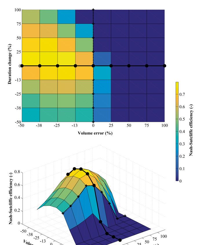
Defensa presentada en la Universidad de Uppsala para ser evaluada públicamente en el salón
Axel Hambergsalen, en el Departamento de Ciencias de la Tierra, Villavägen 16, Uppsala, el
viernes 8 de febrero de 2019 a las 10:00 a. m. para el grado académico de Doctor en Filosofía.
Oponente académico: Profesor Vazken Andréassian (Université Pierre et Marie Curie, Paris).

Resumen
Reynolds Puga, J. E. 2019. Pronósticos de inundaciones en cuencas hidrográficas con escasez de
datos. Maximizando el valor de datos hidro-meteorológicos limitados. Digital Comprehensive
Summaries of Uppsala Dissertations from the Faculty of Science and Technology 1753. 70 pp.
Uppsala: Acta Universitatis Upsaliensis. ISBN 978-91-513-0527-1.

Las inundaciones son una amenaza para la sociedad que pueden causar grandes daños socio-
económicos y pérdida de vidas humanas en muchos lugares del mundo. En cuencas con tiempo
de concentración inferior a 24 h se necesitan modelos que pronostiquen inundaciones con una
resolución temporal superior al día. Datos hidro-meteorológicos a esas resoluciones suelen no
estar disponibles o no existen, especialmente en países en desarrollo. Esta tesis cubre temas
relacionados con la escasez de datos de alta resolución temporal y explora distintos métodos en
los que el valor de los datos existentes se maximiza para mejorar la predicción de inundaciones.
     Al variar la hora de inicio del día en las observaciones se demostró que la definición del día
tuvo un gran impacto en la calibración del modelo y en las simulaciones de caudal, lo cual
puede tener un efecto en la regionalización de parámetros hidrológicos. Se desarrolló un método
para gestionar empíricamente la dependencia de los parámetros con respecto a la resolución
temporal de los datos. Los valores de los parámetros se volvieron independientes de la
resolución temporal de los datos cuando el intervalo de tiempo del modelo fue configurado en
pasos suficientemente pequeños. Como resultado, si se pudiesen obtener datos de entrada en
resoluciones temporales sub-diarias, sería posible hacer pronósticos de inundación en cuencas
con tiempo de concentración menor a un día utilizando parámetros calibrados con series de
tiempo de datos diarios. Se desarrolló un método de calibración basado en unos cuantos
hidrogramas de crecidas para hacer pronósticos de inundaciones más robustos en comparación
con el escenario de no tener ninguna observación. Dos hidrogramas de crecidas mostraron ser
suficientes para calibrar el modelo, pero las predicciones podrían ser más precisas y con menos
incertidumbre si se pudiese disponer de datos de un mayor número de eventos. El uso de
crecidas por encima de un umbral con una alta probabilidad de ocurrencia resultó ser igual de
útil para la calibración del modelo que el uso de eventos más extremos, que ocurren con menor
frecuencia. La precisión de los pronósticos de lluvia impactó altamente el rendimiento de un
modelo de inundación previamente calibrado contra un número limitado de crecidas. Entre los
errores de volumen y duración en los pronósticos de lluvia, el primero tuvo el mayor impacto
en los resultados del modelo.
     Los métodos descritos en esta tesis demostraron ser útiles para predecir inundaciones y se
espera que contribuyan a una mejor evaluación del riesgo de inundaciones en regiones con
escasez de datos. Se requieren estudios adicionales que utilicen más modelos y cuencas para
probar la generalidad de estos resultados.

Palabras claves: inundaciones, falta de datos, valor de información, modelos lluvia escorrentía,
regionalización, pronósticos de lluvia, definición del día, resolución temporal, paso de tiempo.

José Eduardo Reynolds Puga, Universidad de Uppsala, Departamento de Ciencias de la
Tierra, Villavägen 16, SE-75236 Uppsala, Suecia.

© José Eduardo Reynolds Puga 2019

ISSN 1651-6214
ISBN 978-91-513-0527-1.
urn:nbn:se:uu:diva-368532 (http://urn.kb.se/resolve?urn=urn:nbn:se:uu:diva-368532)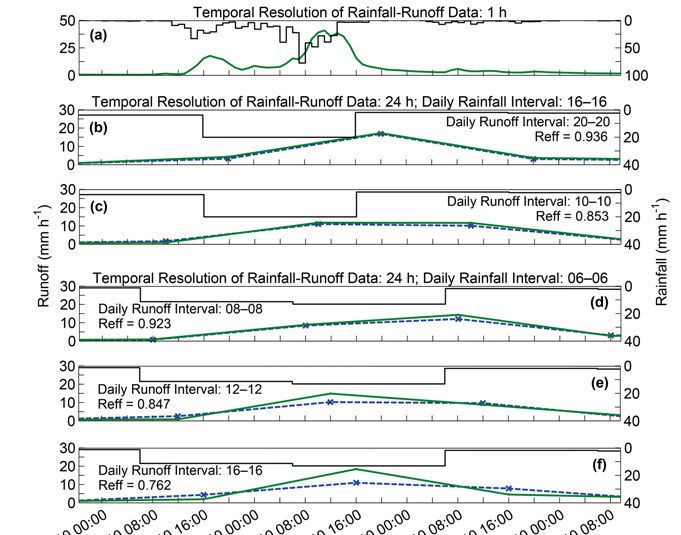
A mi familia.
List of Papers

This thesis is based on the following papers, which are referred to in the text
by their Roman numerals.

      I      Reynolds, J. E., Halldin, S., Seibert, J. & Xu, C. Y. (2018). Def-
             initions of climatological and discharge days: do they matter in
             hydrological modelling? Hydrological Sciences Journal, 63:5,
             836-844, DOI: 10.1080/02626667.2018.1451646

      II     Reynolds, J. E., Halldin, S., Xu, C. Y., Seibert, J., & Kauffeldt,
             A. (2017). Sub-daily runoff predictions using parameters cali-
             brated on the basis of data with a daily temporal resolution. Jour-
             nal of Hydrology, 550, 399–411, DOI: 10.1016/j.jhy-
             drol.2017.05.012

      III    Reynolds, J. E., Halldin, S., Seibert, J., Xu, C. Y. & Grabs, T.
             (2018). Robustness of Flood-Model Calibration using Single and
             Multiple Events. In review. Hydrological Sciences Journal

      IV     Reynolds, J. E., Halldin, S., Seibert, J., Xu, C. Y. & Grabs, T.
             (2018). Flood prediction using uncertain rainfall forecasts and
             parameters calibrated on limited discharge data. Manuscript.

Reprints were made with permission from the respective publishers.

In Paper I, I contributed to the formulation of the research questions and de-
sign of the experiments. I performed the analysis and wrote the manuscript
with contributions from all co-authors. In Paper II, I contributed to the design
of the research experiment with support from all co-authors. I performed the
analysis and prepared the manuscript with contributions from all co-authors.
In Papers III and IV, I contributed defining the research questions, defining
the experiment, performing the analysis, and was the main responsible for
writing the manuscripts.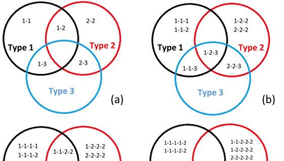
Contents

Introduction ................................................................................................... 13
   Aim of this thesis...................................................................................... 15
Background ................................................................................................... 16
  Flood concepts.......................................................................................... 16
  Flood risk planning and management ...................................................... 16
  Modelling techniques for flood prediction ............................................... 17
  Predicting floods in data-scarce basins .................................................... 19
  Research gaps and opportunities .............................................................. 21
Study area ..................................................................................................... 23
   Boqueron River basin ............................................................................... 23
   Wye River basin ....................................................................................... 25
Methods ........................................................................................................ 27
  Modelling implications of day definition ................................................. 28
  Transferability of model parameters across temporal resolutions ............ 29
  Flood-model calibration based on limited discharge data ........................ 30
     Calibration based on single and multiple events ................................. 31
     Effects on flood predictions caused by rainfall-forecast errors ........... 33
Results ........................................................................................................... 35
  Modelling implications of the day definition ........................................... 36
  Transferability of model parameters across temporal resolutions ............ 40
  Flood-model calibration based on limited discharge data ........................ 43
     Calibration based on single and multiple events ................................. 43
     Effects on flood predictions caused by rainfall-forecast errors ........... 47
Discussion ..................................................................................................... 50
Conclusions ................................................................................................... 54
Acknowledgements ....................................................................................... 56
Sammanfattning på svenska (summary in Swedish)..................................... 58
Resumen en español (summary in Spanish) ................................................. 62
References ..................................................................................................... 66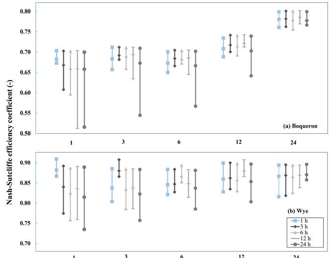
Abbreviations

Ak       Transformation constant
CEH      Centre for Ecology & Hydrology database
ECMWF    European Centre for Medium-Range Weather Forecasts
ENSO     El Niño-Southern Oscillation cycle
EPS      Ensemble prediction system
F1(Ɵ)    Mean volume error of the events
F2(Ɵ)    Mean RMSE of the events
F3(Ɵ)    Mean peak flow error of the events
F(Ɵ)     Aggregate measure of F1(Ɵ), F2(Ɵ) and F3(Ɵ)
FRMS     Flood risk management systems
GA       Genetic algorithm
GLUE     Generalised likelihood uncertainty estimation
HBV      Hydrologiska Byråns Vattenbalansavdelning model
ITZC     Intertropical Convergence Zone
LST      Local standard time
MC       Monte Carlo
MORECS   Meteorological Office Rainfall and Evaporation Calculation
         System
NERC     Natural Environment Research Council
Mp       Number of events in calibration or evaluation
NWP      Numerical weather-prediction
PE       Relative peak-flood error
Reff     Nash‐Sutcliffe efficiency
RMSE     Root-mean-square error
TE       Relative time-to-peak error
UNESCO   United Nations Educational, Scientific and Cultural Organi-
         zation
USGS     United States Geological Survey
UTC      Coordinated Universal Time
VE       Relative volume error
WMO      World Meteorological Organization
Introduction
“What is not started will never get finished”
–Johann Wolfgang von Goethe
Floods can cause detrimental consequences on society, economy and environ-
ment in many parts of the world. On average, about 21 million people world-
wide are affected by river floods each year (Luo et al., 2015). The effects of
floods are notably severe in developing or low-income countries because of
their vulnerability to the occurrence of these phenomena.
Central America is one of the regions in the world most exposed and vulnera-
ble to climatological risks (Dilley et al., 2005; Mucke et al., 2017; UNESCO,
2012). Floods caused by the occurrence of extreme rainfall are the natural dis-
asters that most often occur and that have affected more the Central American
region (Marengo et al., 2014, UNESCO, 2012). The occurrence of large-scale
events in Central America usually causes large amounts of economic and hu-
man life losses (e.g., when Hurricane Mitch hit the region back in 1998, close
to 11,000 people died because of flooding, about 2.7 million lost their homes
and flood damages were estimated to be over 6 billion USD) (Lott et al.,
1999). Moreover, the region is impacted every year by small–medium scale
flood events, that together cause more damage than large-scale events
(UNESCO, 2012).
During the last 60 years, climate trends in Central America have not shown a
significant increase in total amount of rainfall, but the number of events with
high rainfall intensities have increased (Marengo et al., 2014). This has re-
sulted in the occurrence of more floods and an increase of flood economic
losses, and this trend is expected to continue (WMO, 2011). Although the
latter has raised awareness on society to be better prepared for the occurrence
of these phenomena, socio-economic development (i.e., population growth,
urbanisation, expansion on floodplain areas), limited quantity and quality of
observational hydro-meteorological data (Reynolds, 2012; Westerberg et al.,
2010), economic constraints, or passive participation of local authorities in
13flood-forecasting systems have left the region lacking of resilience, anticipa- tion and adaptive capacities to cope with these extreme events and therefore, making the region more vulnerable to the phenomena (Marengo et al., 2014, UNESCO, 2012). Lack of hydro-meteorological data for model calibration has always been an issue for predicting floods in ungauged basins. In Central America, as in many other regions, where floods occur frequently and basins are small–medium sized (∼100–1000 km2) with concentration times smaller than 24 h, there is a demand for flood-forecast models at sub-daily temporal resolutions. Any ap- plication of those models relies on the availability of long-time series of sub- daily observational data, which are commonly rare. Modelling with data at the temporal resolution needed is not always an option, which leaves hydrologists with no other option than to make use of the best data available, if any, to improve the understanding and representation of hydrological processes of such complex hydrological systems. In addition, the lack of quality of the data available in Central America has been one of the main reasons for the limited number of studies or publications made in the region, which has made it more complicated for researchers or practitioners to come up with conclusive state- ments that could help in good planning (Fuentes-Andino, 2017, Marengo et al., 2014, Quesada-Montano, 2017, Reynolds, 2012). Reliable and accurate prediction of floods in data-scarce basins using hydro- logical models is a challenging task. Commonly, their parameters cannot be directly estimated from measurements or basin characteristics and, thus, some calibration is needed to reduce errors in predictions. Data needs in hydrologi- cal models are scale dependent (e.g., the higher the temporal and spatial reso- lutions of the predictions needed, the higher are the data requirements) (McGlynn et al., 2013). As technology, modelling has grown and large data sets over large spatial scales have become available for hydrological applica- tions (e.g., remote sensing), whereas the number of conventional stations has declined in recent years (Stokstad, 1999). This happened even though the value of hydrological data, in terms of benefits, is considered higher than the cost of collecting them (Cordery & Cloke, 1992). If limited observational data are or become available in data-scarce basins, then exploring methods to as- sess how valuable such data could be for meaningful predictions of floods becomes relevant. Ultimately, the available data and developed methods should allow effective responses based on reliable flood-risk predictions. Another problem that arises when predicting floods in fast-response basins is that peak discharges tend to occur as a result of a localised rainfall event and times to peak may be too short for raising adequate warnings based on real- time rainfall observations (Ferraris et al., 2002). In these conditions, the only option is to raise warnings of potential flooding based on rainfall forecasts. 14
Although new technologies and methods have emerged for improving the ac-
curacy of rainfall forecasts, rainfall forecasts are still the main source of un-
certainty in flood forecasting, which limits the usability of hydrological mod-
els in real-time applications (Kobold, 2007). Given the current-state-of-art on
the accuracy of rainfall forecasts, only flood warnings are feasible and further
studies in such area are needed to improve their prediction skills.

This thesis covers issues related to the scarcity and lack of high temporal-
resolution hydro-meteorological data and explores methods where the value
of existing data is maximised to improve flood prediction. The present study
is mainly focused in the Central American region and includes four studies,
which were carried out at the local scale.

Aim of this thesis
The overall goal of this thesis was to enhance water resources and flood man-
agement in data-scarce basins with sub-daily responses by maximising the
value of limited hydro-meteorological data.

In more details, the aims of the thesis were divided into two main parts:
    a. Improving the understanding of the effects of data-related uncertain-
       ties on hydrological models (Papers I, II and IV).
    b. Developing methods to improve the robustness of runoff- and flood-
       model calibration using limited hydro-meteorological data (Papers
       II, III and IV).

                                                                              15
Background Flood concepts Floods are defined as a rising of a body of water that covers an area of land that is normally dry. In general, there are three major flood types: river flood- ing, coastal flooding and urban flooding (Maskey, 2004). This thesis is limited to river flooding, which is characterised by rapid or slow rises of water above their bank levels and subsequently inundating the land around it. The time it takes for floods to build up varies from site to site. In relation to the latter, floods in snow-free basins can be classified as flash floods, short- rainfall floods and long-rainfall floods (Maskey, 2004; Sikorska et al., 2015). Flash floods are common in mountainous areas during the rainy season and are characterised by a rapid and massive increase of water volume, often com- bined with debris flow. They are often caused by rains of short durations (less than half a day) and with intensities that exceed the infiltration capacity of soils. Flash floods occur quickly and build up within a few hours after the occurrence of rainfall, leaving communities with little time to respond and imposing a major challenge to hydrologists to alert for the occurrence of these events (Maskey, 2004, WMO, 2011). Short-rainfall floods are caused by rains with high intensities that last a maximum of one day. Long-rainfall floods are characterised by slow water level rise and by gradual inundation of floodplain. The latter type is generally caused by continuous (lasting several days) and low intensity rainfall events that eventually fill soil-storage capacity (Sikorska et al., 2015). Flood risk planning and management Floodplain areas of many rivers worldwide have been considerably modified because of many global issues (e.g., population and economic growth, degra- dation of ecosystem services). Usual impacts of urban developments include the reduction of the response time of basins and the increase of water volume and peak runoff (Rosbjerg et al., 2013). This together with climate variability and climate change have increased flood risks. The World Meteorological Or- ganization (WMO) defines risk as the probability of detrimental consequences to human lives, environment, loss of life, property and resources caused by 16
interactions between natural or human hazards and vulnerable conditions
(WMO, 2011). The characterisation of flood risks deals with many sources of
uncertainty, of which socio-economic issues are expected to be the largest one
in the future (WMO, 2011).

Adequate warnings allow people to protect themselves and their property from
the harmful effects of floods. Flood risk management systems (FRMS)
emerged as a response to the increase of floods and to satisfy community-
safety and property-protection expectations (WMO, 2011). These systems are
based on the execution of systematic actions in a cycle of preparedness, re-
sponse, recovery and mitigation (WMO, 2011). Flood risk identification, risk
analysis, risk assessment and risk reduction through appropriate policies and
practices are developed within flood risk management systems as a combined
effort between decision makers and experts (Schanze et al., 2006).

The implementation of any flood risk plan requires knowledge of water levels
or flood peaks. Two types of flood predictions are required. One is the predic-
tion of floods in terms of magnitude and timing at a particular location, to-
gether with its inundation extent during its occurrence (i.e., flood water level).
This type of prediction is often required in short-term flood preparedness sys-
tems to raise timely flood warnings. The second one is the prediction of a high
water level or peak discharge likely to occur in the future (i.e., improving
knowledge of the frequency of occurrence of floods of different magnitudes)
(Beven, 2001, Rosbjerg et al., 2013).

In the design and planning processes of flood risk management plans, deci-
sions are made on a level of uncertainty and some risk of failure is accepted
(i.e., balance between cost and losses because of budget limitations) (WMO,
2011). Additionally, flood protection measures are typically designed to deal
with certain flooding limits. However, the capacity of these protections may
be exceeded for the most extreme events (Beven, 2001). Since these measures
cannot protect society completely from flooding, flood forecasting becomes
an essential part of flood management (WMO, 2011). The role of flood fore-
casting is different for each case, and it would be expected that the temporal
and spatial resolutions of meteorological and hydrological forecasts fit the
conditions of the place of interest.

Modelling techniques for flood prediction
One issue that arises in predicting floods is when the natural time delay in a
basin is not sufficiently long to assure enough lead time for responses to be
put in place (Beven, 2009, WMO, 2011). Sufficient lead time is location spe-
cific, varies from minutes to hours or days and depends on the basin’s size,

                                                                               17
river length, river-bed slope and location within a region or country (Romanowicz et al., 2006; WMO, 2011). The magnitude of flood peaks is relative to the interplay between rainfall durations and the mean response time of the basin (Rosbjerg et al., 2013). The largest floods are often triggered by storms with durations equal or longer than the basin’s response time. Usually, small basins have short concentration times, whereas large basins have long concentration times. Because of the latter, flood forecasting modelling in small basins is primarily made using rainfall-runoff models, together with ra- dar rainfall, telemetering rainfall data or rainfall forecasts, whereas in large basins, this usually involves rainfall-runoff and hydraulic models. This thesis is limited to flood predictions using rainfall-runoff models in small basins with sub-daily responses. Three types of models are usually referred in the literature regarding their mathematical representation of hydrological processes: physical, empirical and conceptual models (Xu, 2002). Physically-based models represent hydro- logical processes more realistically based on laws of continuity, energy and momentum. Empirical models have little physical significance and are gener- ally developed using input and output data taken simultaneously. Conceptual models are based on physical laws but in a highly simplified way (Xu, 2002). Spatial variability of the parameters depends on how the model is spatially setup: lumped, semi-distributed or distributed. The choice of the model structure depends on many factors: modelling pur- pose (e.g., requirements of stakeholders), the degree of model complexity in relation to the data available, resource constraints and modeller’s experience (Parajka et al., 2013, WMO, 2011). Complex models, such as those physi- cally-based and distributed, usually require large amounts of hydro-meteoro- logical data, which are commonly not available in data-scarce conditions. Fur- thermore, the use of only runoff data for calibration of distributed models could be highly misleading for identifying model parameters (Blöschl et al., 2008). In principle, parameters in physically-based models should be measur- able. However, this may not be possible because of heterogeneity of the basin characteristics and processes complexity. Complex models usually have a large number of parameters to calibrate which could lead to calibration prob- lems (e.g., overparameterisation, long simulation periods, especially at short temporal resolutions) (Beven, 2001). On the other hand, simple models (e.g., lumped and conceptual) often require little input data, have a considerably lower number of parameters, lower computational demands and have shown to provide as good modelling results for predicting discharge as more complex models (Beven, 2001; Bormann et al., 2009; Franchini & Pacciani, 1991). Ad- ditionally, it is very unlikely that better results will be obtained using distrib- uted instead of lumped models if the available data to represent the natural spatial variability of the basins are limited. 18
Physically-based distributed models are usually used in research to gain a bet-
ter understanding of hydrologic phenomena, whereas conceptual-lumped
models are more widely used for practical applications, water-resources plan-
ning and management. A typical conceptual hydrological model used to pre-
dict discharge in a lumped or semi-distributed way is the HBV model
(Bergström, 1976; Lindström et al., 1997), which has been applied success-
fully in many basins with different climatological conditions (Häggström et
al., 1990; Seibert, 1999; Papers I–IV). One model, the HBV-light version
with its standard model structure set up in a spatially lumped way, was used
in all the papers included in this thesis (model available at
http://www.geo.uzh.ch/en/units/h2k/Services/HBV-Model.html).

Rainfall-runoff modelling has to deal with many sources of uncertainty related
to the data, model and parameters. Therefore, it is advised that rainfall-runoff
predictions should be presented within an uncertainty estimation framework
given all these sources of errors (Beven & Binley, 1992). This was the case in
Papers II, III and IV.

Flood modelling using rainfall-runoff models can be made event- or continu-
ous-based. Event-based models simulate individual flood events in response
to storms over basins. On the other hand, continuous-based models simulate
flood response and moisture content continuously in time, taking into account
all the precipitation that falls over the basins and the movement of water
through them until it reaches their outlet (WMO, 2011).

Predicting floods in data-scarce basins
The main issue for predicting flood hydrograph in data-scarce basins is the
lack of observational discharge data for the selection and calibration of an ad-
equate model for prediction. After a suitable model has been chosen, model
parameters need to be estimated. In conceptual models as the one used herein,
parameters cannot be estimated a priori from measurements (from field exper-
iments or remote sensing) because these are rather more empirical than phys-
ical representations (Parajka et al., 2013).

If basins are ungauged, one approach to overcome this limitation is parameter
regionalisation through statistical or process-based methods (e.g., transferring
the calibrated parameters from gauged to ungauged basins) (Blöschl et al.,
2013). If some observational data are available, these are often at a daily res-
olution. Two approaches have been proposed to bridge the gap between the
daily temporal resolution of the data and the timescale at which fast-flow pro-
cesses occur. One approach is to use daily-calibrated parameters to simulate
runoff at sub-daily resolutions. This approach is applicable when a time series

                                                                             19
of sub-daily input data is or can be made available to force the model (Paper II). However, if basin responses occur at timescales finer than daily, it is worth noting that the starting time of the day of the data could affect model calibra- tion (Paper I) and result in inaccuracies of daily parameters (Littlewood & Croke, 2008) and poor model performance (Bastola & Murphy, 2013). The second approach consists of scaling model parameters when transferring them across temporal resolutions (Bastola & Murphy, 2013; Ficchì et al., 2016; Finnerty et al., 1997; Nalbantis, 1995; Ostrowski et al., 2010; Wang et al., 2009). If time and resources were available, it could be argued that the best approach would be to perform field measurements, preferably including time periods representative of the processes occurring in the basins to be modelled (Seibert & Beven, 2009; Tada & Beven, 2012, Papers III and IV). In such data-limited conditions, it becomes relevant on estimating how valuable a small amount of data could be (Papers III and IV) and how sensitive flood predictions are to errors in rainfall forecasts (Paper IV). 20
Research gaps and opportunities
Predicting floods in data-scarce basins is limited by the availability of good
and sufficiently long time series of sub-daily rainfall and discharge observa-
tions for model calibration. However, this limitation also gives opportunities
for improving knowledge and flood-management practices. For instance, if
the solution is to transfer parameters across temporal resolutions without scal-
ing, for example from daily to hourly, one question that arises before going
through this procedure is whether the starting time of the day – referred here
as the definition of the day – of the daily records affects parameter estimates
and runoff prediction. Although the effects on rainfall-runoff models caused
by several uncertainties related to hydro-meteorological data have been
widely investigated (Andréassian et al., 2001; Gan et al., 1997; Jie et al., 2018;
Xu et al., 2013), those caused from the definition of the day have received
little interest (Jian et al., 2017; Vincent et al., 2009; Westerberg et al., 2014).
The answer to this question could have consequences for regionalisation and
flood forecasting. This was investigated in one study (Paper I) where model
performances obtained using different definitions of the climatological and
discharge days were compared.

Equally important, flood managers may wonder whether the transferability of
parameters across temporal resolutions result in a significant decrease in
model performance. Parameters calibrated at different temporal resolutions
have been shown to vary considerably, to be dependent on the temporal reso-
lution of data (Bastola & Murphy, 2013; Kavetski et al., 2011; Littlewood,
2007; Littlewood & Croke, 2008; Ostrowski et al., 2010) and to be influenced
by the rainfall intensity-duration relationship (Wang et al., 2009). Causes of
these dependencies have been attributed to the loss of information of the phys-
ical processes as the data are averaged over coarser temporal resolutions
(Littlewood & Croke, 2008, 2013, Ostrowski et al., 2010). A study on the
impact of temporal resolution of data on parameter inference by Kavetski et
al. (2011) shows that false strong parameter temporal-resolution trends
emerge when unreliable modelling time-stepping schemes or numerical meth-
ods are implemented to solve model equations. They argue that using robust
numerical methods and heteroscedastic residual-error models stabilises and
reduces the strength of model-parameter dependencies on the temporal reso-
lution of data. A study in line with the latter authors (Paper II), tested the
hypothesis that temporal-resolution dependencies of the parameters of a
bucket-type hydrological model may be neglected when a common numerical
resolution or modelling time-step is implemented.

Lack of resources for the establishment and maintenance of permanent dis-
charge stations has been one of the reasons for the interest of researchers and
practitioners on knowing how valuable small amounts of data might be for

                                                                                21
model calibration. Several studies on parameter and performance variability caused by the length or quantity of the calibration data have reported good modelling predictions (Anctil et al., 2004; Brath et al., 2004; McIntyre & Wheater, 2004; Melsen & Teuling, 2014; Seibert & Beven, 2009; Sorooshian et al., 1983; Tada & Beven, 2012; Yapo et al., 1996). Results of these studies diverge from site to site and are difficult to generalise as a unique solution for data-scarce conditions. This topic was further investigated in two studies (Pa- pers III and IV). In the first (Paper III), it was hypothesised that adequate model calibration in a data-scarce environment is possible when hydrographs of only a few events are available, and assessed the value of such events in terms of quantity and information content. The second study (Paper IV) also deals with flood- model calibration based on limited discharge data, as in the former, and tested the hypothesis whether event hydrographs above a threshold with a high fre- quency of occurrence can be useful in calibration to provide reliable flood predictions. Furthermore, this study assessed the importance of rainfall-fore- cast errors for meaningful predictions of floods in such data-limited condi- tions. The motivation of the latter study was to contribute in knowledge on how errors in the rainfall forecasts affect flood predictions. Overall, all studies included in this thesis are interesting from a research and practical perspective, and contribute to the ultimate goal of enhancing water- resources and flood management in basins with sub-daily responses and data- limited conditions. 22
Study area
Two basins were selected to carry out the investigations included in this thesis,
one in Panama and one in the United Kingdom. The selection of these basins
was based on their characteristics and their data availability for each study. In
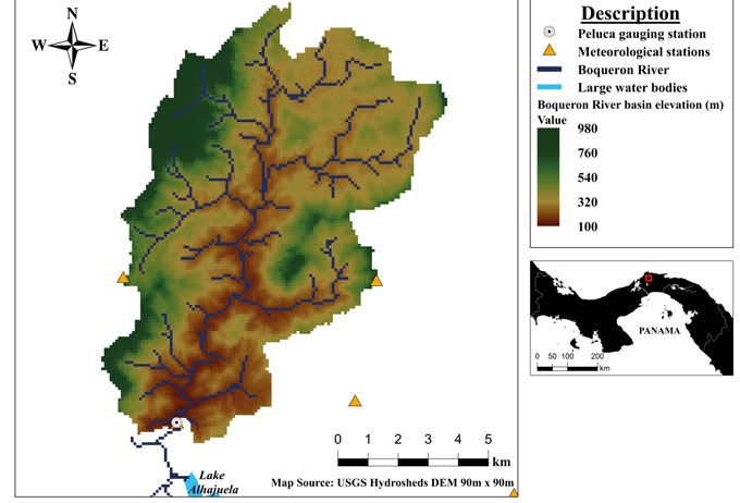
this regard, the tropical Boqueron River basin (Fig. 1), located in Panama
(Central America), was selected because it had data at a high temporal resolu-
tion adequate for performing the analysis in all the papers included in this
thesis (Papers I–IV) and because it represents a typical basin in Central
America that frequently suffers the effects of floods. Similarly, the headwater
region of the temperate Wye River basin (Fig. 2), located in mid-Wales, was
selected because it has been the subject of many water-resources studies and
because it also had data at a high temporal resolution adequate to explore on
the transferability of model parameters across temporal resolutions (Paper
II). Both basins have similar features (e.g., sub-daily lag-times, drainage areas
under 100 km2) and different seasonalities.
Boqueron River basin
The climate of Central America is highly variable in time and space. Rainfall
in the region depends on: (1) the annual movement of the inter-tropical con-
vergence zone; (2) the presence of northeast trade winds; (3) the mountainous
terrain (Georgakakos et al., 1999); and (4) the ENSO phenomenon
(Ropelewski & Halpert, 1987). Rainfall is generally convective and oro-
graphic, and occurs mostly in the form of heavy downpours resulting from
thunderstorms. Most of the rain falls between May and December, whereas
the other months are relatively dry. The tropical Boqueron River basin was
the study area in Papers I–IV. Forests predominantly covered the 91 km2 ba-
sin, and its elevation ranges from 100 to 980 m a.s.l. (USGS, 2016). The basin
has 1−3 h lag times (i.e., time difference between the peak precipitation and
the peak discharge). The 1997–2011 mean annual rainfall in the basin is 3,800
mm y-1 and runoff 2,728 mm y-1.
Areal precipitation was estimated by Thiessen polygons from four stations of
hourly rainfall data, available within and close to the basin for 1997−2011.
Rainfall forecasts were needed in Paper IV but these were not available for
23the basin. Instead, several rainfall-forecast scenarios were generated based on real-time observations but with volume and duration errors added. The stage at the Peluca station was recorded continuously in a nonstationary river-cross section using a float inside a stilling well and stored every 15 minutes. Stage-discharge ratings at this station were made at least once a month and rating-curve updates were made in case of change. Hourly maximum-an- nual discharge for 27 years (1985–2011) and 15 years of continuous discharge data (1997–2011) were available. Daily pan evaporation data for the period 1985−2010 from the Tocumen station, located 36 km southeast of the basin, were used to estimate long-term daily mean values of potential evaporation. The hydro-meteorological data of this basin were quality-controlled in Paper II. Figure 1. Location of Boqueron River basin in Panama. This basin was the study area in Papers I–IV. 24
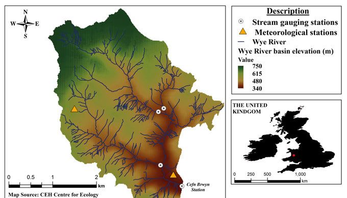
Wye River basin
The headwater region of the temperate Wye River basin at Cefn Brwyn was
the second basin used in Paper II. The 10.6 km2 basin is one of the Plynlimon
research basins operated by the Center for Ecology and Hydrology (United
Kingdom), and is predominantly covered by open moorland for grazing sheep.
It is a flashy basin with 1−3 h lag times. Its elevation ranges from 341 to 735
m a.s.l. (CEH, 2016) and it is characterised by rolling hills. Most of the rainfall
falls in the autumn and early winter months (October−January), while the late
spring and early summer months are considerably drier. The mean annual rain-
fall is 2,490 mm y-1 and runoff 2,170 mm y-1 (NERC, 2003).

Precipitation was measured by two hourly meteorological stations, stage was
gauged at a 3-bay Crump profile weir and calculated discharge was stored
every 15 min. The rainfall-runoff data of the Wye River basin at Cefn Brwyn
were made available online at http://tdwg.catchment.org/datasets.html. The
data were at the 1-h temporal resolution, covered a 2-year period (1 Jan 1987–
1 Jan 1989) and were not quality-controlled for their use because they were
considered to have a high quality. Long-term monthly MORECS potential
evaporation estimates for South Britain for the period 1961−1990, available
from Kay & Davies (2008), were used as a reference for the basin but cor-
rected for differences in altitude based on a methodology by Finch & Hall
(2001).

Figure 2. Location of the Wye River basin in Wales. This basin was one of the study
areas in Paper II.

                                                                                25
26
Methods
“Research is what I’m doing
when I don’t know what I’m doing!”
–Wernher von Braun
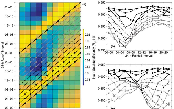
27Modelling implications of day definition The aim of Paper I was to assess how different definitions of the climatolog- ical and discharge days affected a rainfall-runoff model. This was done in four steps. First, 1-h rainfall and runoff data were aggregated to 12 different sets of daily values (i.e., different 24-h intervals). A first daily time series resulted from aggregating the 1-h data for the time interval 00−00, a second for the 02−02 interval, and consecutively every two hours until 22−22. Second, each of the 12 daily rainfall time series was disaggregated uniformly into 1-h time series to drive the model and generate 1-h runoff. Third, 1-h runoff simulations were aggregated to daily steps based on the 24-h interval for each of the 12 daily runoff time series. This resulted in 144 model set-ups (i.e., 12 daily rain- fall time series, one for each climatological-day definition, for each of the 12 daily runoff time series). Fourth, an optimisation procedure based on a genetic algorithm (GA) was applied to each model set-up and their model perfor- mance was compared. The differential equations in the HBV-light version are solved numerically using the explicit Euler and operator-splitting schemes (adding or subtracting fluxes in a distinct order). These simple methods can be numerically unstable and can return unreliable numerical solutions when used with a daily model- ling time step. However, these schemes are expected to return numerical so- lutions approximate to the true or exact solution when the modelling time-step is sufficiently small. To avoid numerical artefacts, daily runoff was simulated with a 1-h modelling time step, for practical purposes, regardless of the daily input data. 28
Transferability of model parameters across temporal
resolutions
The motivation of Paper II was to explore the possibilities of simulating sub-
daily runoff where data at these resolutions are not available for calibration.
Here, it was hypothesised that model-parameter dependencies caused by the
temporal resolution of the data and by numerical issues might be neglected
when a common numerical resolution or modelling time-step is implemented.
After the hourly precipitation and runoff datasets of the two basins chosen for
this study were aggregated to 3-, 6-, 12- and 24-hourly time series, the exist-
ence of model-parameter dependencies on the temporal resolution of data was
studied in two steps. First, by comparing the distribution of parameter values
calibrated from Monte Carlo (MC) simulations of 1-, 3-, 6-, 12- and 24-hourly
runoff using the explicit Euler method while simulating in modelling time-
steps of 1 h. Second, a cross-temporal-resolution comparison of model perfor-
mance was made, where calibrated parameter sets were used to simulate run-
off at the other four temporal resolutions for which they were not calibrated.
Similarly as in Paper I, runoff was simulated with a 1-h modelling time step,
regardless of the temporal resolution of the input data, to avoid numerical ar-
tefacts.
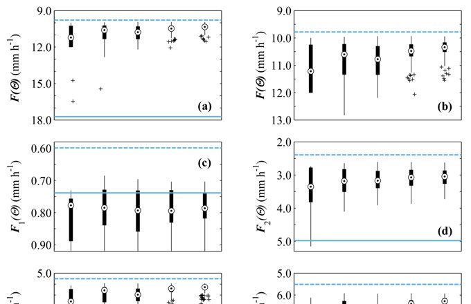
29Flood-model calibration based on limited discharge data For the scenario of no discharge data available for calibration, knowing how valuable a small amount of data might be for such a purpose is critical knowledge. Two studies were carried out to address the latter question, which could help to improve the robustness in flood-model calibration (Papers III and IV). In one study (Paper III), the model was calibrated on the basis of single and multiple events and then tested in validation to assess their ability to predict floods. In this study, it was hypothesised that adequate model calibration in a data-scarce environment is possible when hydrographs of only a few events are available. More specifically, this study aimed to answer how many high- flow events are needed in calibration to achieve an adequate flood prediction. Furthermore, the information content of individual extreme events was com- pared to determine how informative they were in calibration. A subsequent study (Paper IV), focussed on the question of whether hydro- graphs above a threshold with a high frequency of occurrence can be useful in flood-model calibration and forecasting. Here, rainfall inputs in forecasting were assumed to have a quality as good as that of real-time observations. In addition, the effects of rainfall-forecast errors on a flood model calibrated on limited discharge data were assessed. Two thresholds values were used to select the events for calibration: (1) the median annual flood, which is an extreme value with a low frequency of oc- currence (489 m3 s-1 or 19. 4 mm h-1, return period of 2.33 years) (Papers III and IV) and (2) a more relaxed threshold (125 m3 s-1 or 5 mm h-1, return period of 1.01 years), which has a higher frequency of occurrence than the former. The first threshold is at the 50th percentile of the maximum-annual discharge data set, whereas the second is at the 1st percentile of the same data set and it is about four times smaller than the former. Ten events were found above the first extreme threshold, whereas 107 were found above the threshold with a higher frequency of occurrence. Prediction performance in calibration was assessed for the different scenarios of data availability based on a joint objective function, F(Ɵ), which comprised three goodness-of-fit measures: (1) mean volume error of the events, F1(Ɵ), (2) mean root mean square error (RMSE) of the events, F2(Ɵ), and (3) mean peak flow error of the events, F3(Ɵ). F1(Ɵ) relates to relative volume error (VE), F2(Ɵ) to Nash‐Sutcliffe efficiency (Reff), and F3(Ɵ) to relative peak-flow error (PE). 30
Calibration based on single and multiple events
In Paper III, it was assumed that the number of event hydrographs available
for calibration (Mp) varied from one to five. The model was calibrated for all
possible event combinations for a given value of Mp. Calibrated parameters
were subsequently used in validation to simulate floods and their predictive
ability was assessed. Each event combination had its own number of behav-
ioural parameter sets that resulted in specific model performances in valida-
tion. The median of those performances, referred here as median model per-
formance, was computed for each event combination. Finally, median model
performances achieved in validation were compared for different values of
Mp. Here, median value of accuracy for every value of Mp is referred as the
median of the median model performance values.

To assess the value of individual extreme events in terms of their information
content, Paper III compared median model performances in validation based
on the types of events used in calibration for each value of Mp. First, the ten
calibration events were classified into three types based on their characteris-
tics. Then, all possible event combinations for a given Mp were classified into
three larger groups according to its event-type combination (Fig. 3).

Using a fixed number of multiple events in calibration, Paper IV explored if
hydrographs above a threshold with a high frequency of occurrence can be
useful in flood-model calibration and forecasting. Two sets of event combina-
tions were generated based on events above thresholds with a high and a low
frequency of occurrence. The HBV model was calibrated for both sets of event
combinations and their flood predictive ability was tested in forecasting using
a rainfall forecast with a quality as good as that of real-time field measure-
ments. Median model performances in the validation of the two sets of event
combinations were compared.

Median model performances in the validation period for Papers III and IV
were compared to an upper and lower benchmark to show the value of the
calibration data in comparison to when no data were available (Seibert et al.,
2018). The upper benchmark represented the best model performance that
could be achieved with the data of the study basin, whereas the lower bench-
mark represented what could be achieved if only information of parameter
value ranges was available. The model was run continuously assuming the
input-data time series were available and that discharge data from only Mp
events were available for calibration.

                                                                            31
Figure 3. Classification of calibration setups, based on their event-type combination, to groups representing the information content of each type of event when Mp equals (a) two, (b) three, (c) four, and (d) five. For every Mp value, each circle represents the information content of one type of event and the serial numbers inside them indicate the event-type combinations of the calibration setups included in each group (Paper III). 32
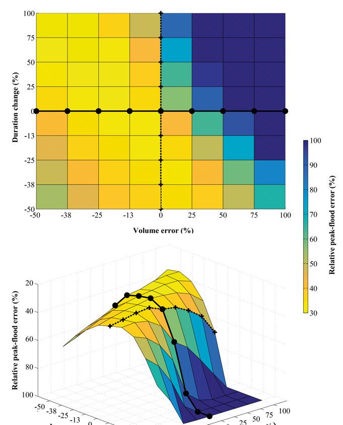
Effects on flood predictions caused by rainfall-forecast errors
Paper IV also aimed at assessing the effects of rainfall-forecast errors on
flood models calibrated on a few event hydrographs. The event combinations
used in calibration were those with the events above the threshold with a small
return period (i.e., 1.01 years) and the predictive ability of the calibrated pa-
rameters was further tested using several rainfall-forecast scenarios as input
to the model. The rainfall forecasts were based on real-time observations but
included duration and volume errors. Nine volume-error percentages were
considered, each of them with nine duration-error percentages, which resulted
in 81 rainfall-forecast scenarios with different degrees of uncertainty. The cen-
tre of mass of each rainfall event was used as a reference to increase and re-
duce their duration in both directions. The median value of accuracy obtained
for all the rainfall-forecast scenarios was compared to assess the effects on
flood predictions caused by uncertainties on rainfall forecasts.

                                                                              33
34
Results

          “We are not rich by what we possess
                but what we can do without.”
                             – Immanuel Kant

                                          35
Modelling implications of the day definition The definitions of both the climatological and discharge days had a large im- pact on the maximum model performance (Fig. 4). Model performance varied greatly along both axes of the climatic and discharge day definition, and changed gradually, shifting parallel to the main diagonal (Figures 4 and 5a). The highest efficiencies were found when the 24-h runoff interval lagged the 24-h rainfall interval by 2–4 h. For those cases, the model had sufficient water in storage before the largest runoff peaks had occurred, which facilitated the model to fit the observations. Furthermore, efficiencies varied considerably along the diagonals (Fig. 5). The rainfall interval that had the greatest performance variability was 06–06. Model performance varied greatly for most of the 24-h runoff intervals, except for the intervals between 06–06 and 12–12. Model performance for specific 24-h intervals could be explained by explor- ing the hourly distribution of rainfall and runoff during calibration. It was gen- erally difficult to achieve high model performance when the climatological- day definition split the most extreme rainfall events. However, model perfor- mance varied less for some 24-h runoff intervals because the extreme runoff events were split into two, which made it less problematic to fit the observa- tions. If the definition of the climatological day is adequate, then model performance varies less regardless of the definition of the discharge day. The latter was confirmed by using hourly rainfall data as input to simulate daily runoff with different starting times of the day. This eliminated the effects caused by the definition of the climatological day, and as a result, those effects caused by the definition of the discharge day were almost non-existent. Hydrographs from an extreme event illustrated the behaviour of simulations with different day definitions (Fig. 6). 36
You can also read