RELEASE GUIDE IMAGE SCOUT 2018 - Hexagon Geospatial Community
←
→
Page content transcription
If your browser does not render page correctly, please read the page content below
RELEASE GUIDE
IMAGE SCOUT 2018

Version 16.5
February 13, 2018
Contents

About This Release ........................................................................................................................ 6
Image Scout.................................................................................................................................... 6
New Platforms ................................................................................................................................ 7
          Licensing ............................................................................................................................... 7
Impacts ........................................................................................................................................... 7
          GeoWorkspaces ................................................................................................................... 7
New Technology ............................................................................................................................ 7
          GeoMedia Professional ......................................................................................................... 7
          New Technology (16.1) ......................................................................................................... 7
          Data Access .......................................................................................................................... 7
                           PostGIS data server ............................................................................................ 7

                           WMS data server ................................................................................................. 7

                           WMTS data server ............................................................................................... 8

                           Oracle LTT data server ........................................................................................ 8

                           Database Utilities................................................................................................. 8

          Feature Caching ................................................................................................................... 8
                           Logging................................................................................................................ 8

                           Improved performance ........................................................................................ 8

                           Compatibility with Advanced Feature Model ........................................................ 8
          Data Output........................................................................................................................... 9
                           OutputToTableService ......................................................................................... 9
          Analysis ................................................................................................................................ 9
                           Spatial Intersection command and SpatialIntersectionPipe ................................. 9

          Spatial Modeling ................................................................................................................. 10
                           Run Spatial Model command............................................................................. 10

                           Explorer window ................................................................................................ 10

February 13, 2018                                                                                                                                   2
Support for Spatial Model Results in commands ............................................... 11
Sample Spatial Models ...................................................................................... 11
Spatial Model Editor .......................................................................................... 12
Advanced Feature Model .................................................................................................... 12
AFMConvertService .......................................................................................... 12
Compatibility with feature caching ..................................................................... 12
New Technology (16.2) ....................................................................................................... 12
General ............................................................................................................................... 12
Application Window ........................................................................................... 12
InvokeCommand method................................................................................... 12
Coordinate Systems ............................................................................................................ 12
Geodetic Datums ............................................................................................... 12
EPSG Codes ..................................................................................................... 13
Datum Transformations ..................................................................................... 13
Data Output......................................................................................................................... 13
OutputToTableService ....................................................................................... 13
Map Display ........................................................................................................................ 13
Thematic Legend Entries ................................................................................... 13
Spatial Modeling ................................................................................................................. 14
Sample Spatial Models ...................................................................................... 14
New Technology (16.5) ....................................................................................................... 14
General ............................................................................................................................... 14
Setup ................................................................................................................. 14
Sample Data ...................................................................................................... 14
Data Access ........................................................................................................................ 15
GeoPackage data server ................................................................................... 15
New Warehouse command ............................................................................... 16
Database Utilities............................................................................................... 17
February 13, 2018 3Batch Publishing for PostGIS ............................................................................ 17
GML data server ................................................................................................ 18
WFS data server................................................................................................ 21
Define Warehouse Configuration File utility ....................................................... 24
Data Capture ....................................................................................................................... 24
Select Set Properties ......................................................................................... 24
Offline Editing .................................................................................................... 24
Spatial Modeling ................................................................................................................. 24
Spatial Model Editor .......................................................................................... 24
New Operators .................................................................................................. 24
Expressions within Operators ............................................................................ 25
Enhancements to Existing Operators ................................................................ 26
Other New Operators ........................................................................................ 27
Sample Spatial Models ...................................................................................... 27
GeoMedia Image Professional ............................................................................................ 28
Image Light Table Plus 2018............................................................................................... 28
GeoMedia GeoDEX ............................................................................................................ 28
GeoMedia 3D ...................................................................................................................... 29
Save and Load Import 3D Objects Settings ........................................................................ 29
Predefined Styles ................................................................................................................ 29
First Person View ................................................................................................................ 29
Latin-1 (ISO-8859-1) Character Encoding ........................................................................... 29
Local Origin Definition for Trimble SketchUp Files .............................................................. 29
Define Coordinate System for Hexagon Point Clouds ......................................................... 29
System Requirements ................................................................................................................. 29
System Requirements Notes............................................................................................... 31
Issues Resolved ........................................................................................................................... 32
GeoMedia Professional ....................................................................................................... 32
Issues Resolved (GeoMedia 16.1)..................................................................... 32
February 13, 2018 4Issues Resolved (GeoMedia 16.2)..................................................................... 45
Issues Resolved (GeoMedia 16.5)..................................................................... 54
GeoMedia Image Professional ............................................................................................ 66
GeoMedia GeoDEX ............................................................................................................ 67
GeoMedia 3D ...................................................................................................................... 67
Deprecated ................................................................................................................................... 70
Windows 8 .......................................................................................................................... 70
About Us ....................................................................................................................................... 70
Copyright ...................................................................................................................................... 71
February 13, 2018 5About This Release
ABOUT THIS RELEASE
This document describes the enhancements for Image Scout. Although the information in this document is current
as of the product release, see the Hexagon Geospatial Support website for the most current version.
This release includes both enhancements and fixes. For information on fixes that were made to Image Scout for
this release, see the Issues Resolved section. For information on enhancements, see the New Technology section.
This document is only an overview and does not provide all of the details about the product's capabilities. See the
online help and other documents provided with Image Scout for more information.
IMAGE SCOUT
As a viewing and analysis tool, Image Scout allows you to combine multiple images into a virtual mosaic for
seamless smooth roam over a vast and complex area. Using Image Scout, you can perform complex queries on
spatial and attribute data from various sources and produce numerous views of highly sophisticated maps in a
single GeoWorkspace. Furthermore, Image Scout lets you print those map views on a single sheet and add
borders, marginalia, and other finishing touches.
Image Scout is composed of three different Hexagon Geospatial products:
• GeoMedia Professional: An enterprise GIS that is the perfect tool for collecting and analyzing GIS data,
populating an enterprise database, and turning information into precise finished maps for distribution and
presentation. Includes a complete Grid tool kit for spatial and distributional analysis of any kind of gridded
data, including raster, elevation, LiDAR and others. Extensive Help examples direct the user to many
different types of analyses such as: hot spot analysis, least cost routing, contour generations and many
more.
• GeoMedia Image Professional: Provides image light table capabilities for creating virtual mosaics, image
enhancements, image comparison, image annotation, research and negation, directed search over linear
and area features, and much more: based on Overwatch Systems' Image Light Table Plus (ILT) product.
• GeoMedia GeoDEX: A viewing and analysis tool for geographic information providing the capability for the
user to create MGRS grids and work with specialized image data sets such as CADRG, CIB, and others.
Image Scout 3D also includes the following product:
• GeoMedia 3D: Provides an integrated 3D visualization and analysis environment. You can visualize,
navigate, analyse, and interact with 3D data natively in GeoMedia. In addition, you can dynamically
integrate surfaces, imagery, feature data, and vector data to provide a 3D view of all data sources in a
GeoMedia 3D map window.
February 13, 2018 6New Platforms NEW PLATFORMS LICENSING Starting with the Power Portfolio 2018 release, licenses are no longer be based on Certificate-file based technology. Instead, licenses are based on Activation IDs, allowing you to activate products without providing Host IDs or other hardware-related parameters. You can also re-host without emailing the licensing team for assistance. The Power Portfolio 2018 release also includes improved tools that make it easier to install licenses, set up license servers, and provide more professional error handling. Finally, the Power Portfolio 2018 release includes improved customer notification in the products, such as an “end of subscription” message in the Start-up screen. These more secure and automated processes, along with a new licensing portal, provide you with a better overall user experience. IMPACTS GEOWORKSPACES GeoWorkspace files from GeoMedia 2016 and previous may be opened in GeoMedia 2018. GeoWorkspace files saved with GeoMedia 2018 cannot be opened in GeoMedia 2016 and previous. NEW TECHNOLOGY GEOMEDIA PROFESSIONAL NEW TECHNOLOGY (16.1) DATA ACCESS POSTGIS DATA SERVER The PostGIS data server now better supports multi-table read-write views of various kinds, and supports queries against the picklist table. The PostGIS data server now filters out feature classes which have table and field names containing uppercase characters. Such characters require special syntax in SQL and are not supported within GeoMedia. WMS DATA SERVER The WMS data server now automatically recognizes and handles certain Coordinate Reference Systems as being defined with swapped axes (e.g. Y-X rather than X-Y). It is no longer necessary to add an .ini file entry to convey February 13, 2018 7
New Technology

the need to swap axes, in most such cases. The .ini file entry is still available for cases in which the software
misinterprets the CRS, or in which the WMS site results don’t match the CRS.

WMTS DATA SERVER
The WMTS data server now automatically recognizes and handles certain Coordinate Reference Systems as
being defined with swapped axes (e.g. Y-X rather than X-Y). In addition, an .ini file entry is now available for cases
in which the software misinterprets the CRS, or in which the WMTS site results don’t match the CRS.

ORACLE LTT DATA SERVER
Further changes to optimize LTT-specific queries for Oracle 12c have been made to resolve performance issues.
These are beyond the changes in GeoMedia 16.1 for CR# 1-S0AO0B.

DATABASE UTILITIES
We’ve improved the PostGIS capabilities within Database Utilities, as well as changed the definition of the
GFeatures view to filter out feature classes which have table and field names containing uppercase characters.
Such characters require special syntax in SQL and are not supported within GeoMedia.

FEATURE CACHING
LOGGING
An optional log file may be created, and if present the feature caching system will provide diagnostic information
about whether and how caches are being used at runtime.

IMPROVED PERFORMANCE
IFC files that are created with GeoMedia Desktop 16.1 are organized for even better performance, especially for
cases of very large files accessed over a network share. Previously published feature cache files remain
compatible, but performance will improve if the files are newly published.

COMPATIBILITY WITH ADVANCED FEATURE MODEL
On the New Warehouse Connection command as well as the Properties dialog of the Warehouse Connections
command, the “Enable advanced feature model” and “Enable feature caching” checkboxes are no longer mutually
exclusive. The performance improvements that come with feature caching are now available for AFM-configured
warehouses as well.

February 13, 2018                                                                                                    8
New Technology

DATA OUTPUT
OUTPUTTOTABLESERVICE
OutputToTableService now provides a .DisableTransactions property which, when set to True, causes the object
to avoid all BeginTrans, CommitTrans, and Rollback operations. Control of transactions is left completely to the
calling application.

ANALYSIS
SPATIAL INTERSECTION COMMAND AND SPATIALINTERSECTIONPIPE
SpatialIntersectionPipe and the Spatial Intersection command that uses it, now transmit the individual key
definitions of the incoming recordsets into the output query as a composite key.

February 13, 2018                                                                                                  9
New Technology

SPATIAL MODELING
RUN SPATIAL MODEL COMMAND
This new command integrates spatial models into GeoMedia. It allows the user to select a model (.gmdx file)
created through the Spatial Model Editor utility; fill in any parameters in the model dynamically, especially features
input to the model from the GeoWorkspace; and then see the various results from the model added to the map
within the GeoWorkspace.

EXPLORER WINDOW
A new “Spatial Models” entry in the Explorer window lets you easily see what spatial models have been run within
the GeoWorkspace, and to manage them by rerunning them, changing their names and other properties, and
deleting them. You can also see the various results of the run, and display them in a map or data window.

February 13, 2018                                                                                                   10
New Technology

SUPPORT FOR SPATIAL MODEL RESULTS IN COMMANDS
Many commands in GeoMedia which present features for selection through a feature treeview control, now support
the selection of spatial model results in addition to feature classes, queries, categories, and the like. In such
cases, a new “Spatial Models” branch appears in the tree, with each spatial model in the GeoWorkspace visible
beneath it. Expand a model and then select the various results for processing.

Commands which support selection of spatial model results include: Add Legend Entries, Add Thematic Legend
Entry, New Data Window, Change Data Window Contents, Output to Feature Classes, Attribute Query, Attribute
Selection, Join, Union, Spatial Query, Spatial Intersection, Spatial Difference, Buffer Zone, Analytical Merge,
Aggregation, and Functional Attributes.

To use spatial model results within commands that do not yet support them directly, output the results to a feature
class via Output to Feature Classes, or build a query on the results via Attribute Query that passes through all of
the features.

SAMPLE SPATIAL MODELS
The default spatial models folder (C:\GeoWorkspaces\SpatialModels) now contains sample models that
demonstrate use of certain operators and demonstrate how to construct a model properly for use with the Run
Spatial Model command.

February 13, 2018                                                                                                 11
New Technology

SPATIAL MODEL EDITOR
This utility has been upgraded to the latest version released with ERDAS IMAGINE 16.1.

ADVANCED FEATURE MODEL
AFMCONVERTSERVICE
AFMConvertService is a new component that provides the ability through API to convert a standard non-AFM
warehouse to a warehouse configured for the Advanced Feature Model. This capability was previously available
only through GUI.

COMPATIBILITY WITH FEATURE CACHING
On the New Warehouse Connection command as well as the Properties dialog of the Warehouse Connections
command, the “Enable advanced feature model” and “Enable feature caching” checkboxes are no longer mutually
exclusive. The performance improvements that come with feature caching are now available for AFM-configured
warehouses as well.

NEW TECHNOLOGY (16.2)

GENERAL
APPLICATION WINDOW
The name of the active GeoWorkspace is now displayed in the caption of the application window at all times,
whether the active map, data, or layout window is maximized or not. Previously the GeoWorkspace name was
shown only when a child window was not maximized.

INVOKECOMMAND METHOD
The method InvokeCommand on the Application object now supports invocation of the Select Tool command.

COORDINATE SYSTEMS
GEODETIC DATUMS
Support for the following datums has now been added:

February 13, 2018                                                                                             12
New Technology

    •   Oman National Geodetic Datum 2014. This addition includes support for use of ONGD14 with UTM zones
        39-41 North. It also includes autodt.ini support for 7-parameter datum transformation between ONGD14
        and WGS84 (ITRF89).
    •   Geocentric Datum of Australia 2020. This addition includes support for use of GDA2020 with MGA (UTM)
        zones 46-59 South. It also includes autodt.ini support for 7-parameter datum transformation between
        GDA1994 and GDA2020.
    •   Ross Sea Region Geodetic Datum 2000.
    •   NAD83(NSRS 2011) and associated PA11 and MA11. This addition includes support for use of
        NAD83(NSRS PA11) with Hawaiian State Plane 1983 zones and NAD83(NSRS 2011) with other State
        Plane 1983 zones, as well as use with various UTM zones.
    •   Rauenberg Datum/83 and Potsdam Datum/83. Standardizes support for Gauss-Kruger (3 degree) zones
        and 7-parameter datum transformations to ETRS89 that were previously emulated.

EPSG CODES
EPSG support has now been updated from version 8.8 to version 9.0 of the geodesy dataset. EPSG added 139
new Coordinate Reference System codes; this release adds support for 110 of them (those unsupported are CRS
types not intrinsically supported in GeoMedia, such as Engineering or Vertical-only CRS).

DATUM TRANSFORMATIONS
A new transformation is now introduced which streamlines the number of steps needed in a transformation path
involving one of the example Named Datum entries associated with the NAD83 geodetic datum in the United
States. This improves performance for large datasets.

DATA OUTPUT
OUTPUTTOTABLESERVICE
For the Access data server only, as a consequence of Create Table committing any open transaction in Access,
the new transaction-disabling logic will now begin a new transaction after the Create Table. For this scenario, the
calling application must delete the created table itself, when performing rollback logic.

MAP DISPLAY
THEMATIC LEGEND ENTRIES
On the Legend Entry Properties dialog for Unique Value and Range thematic legend entries, the column header
over the on/off checkboxes in the thematic class grid can now be used to turn on and off the entire set of
checkboxes together. Click on the column header to toggle the checkbox for the topmost row, and to set all other
checkboxes to the same value. Click again to reverse the settings for all classes.

February 13, 2018                                                                                                13
New Technology If a Unique Value or Range legend entry is not displayed in the map window, and the legend window is used to display one of its child legend entries representing a thematic class, the parent legend entry will now automatically have its display turned on so that the thematic class is displayed in the map. SPATIAL MODELING SAMPLE SPATIAL MODELS Additional sample models for raster data have been introduced. NEW TECHNOLOGY (16.5) GENERAL SETUP This Release Guide is now available directly from the Start menu. SAMPLE DATA Some obsolete sample data has now been eliminated from the delivery. This includes both GeoWorkspaces and Access warehouses. February 13, 2018 14
New Technology

All remaining sample GeoWorkspaces have been upgraded to GeoMedia Desktop 16.5 format.

DATA ACCESS
GEOPACKAGE DATA SERVER
A new read-write GeoPackage data server has been introduced with GeoMedia 16.5. It supports the OGC
GeoPackage 1.2 Encoding Standard, which includes geospatial extensions to SQLite. Like the Access data

server, it provides a personal, portable, free, file-based warehouse type which requires no separate software
installation or licensing.

February 13, 2018                                                                                               15
New Technology
The GeoPackage data server is supported in most parts of all three tiers of the GeoMedia Desktop, with the
exception of the following:
• The library system
• The catalog system
• The grid system
• The PublishIFC utility
• Output of static labels
NEW WAREHOUSE COMMAND
This command now supports GeoPackage warehouses in addition to Access warehouses, and provides a
warehouse template for both. The default new warehouse type is now GeoPackage.
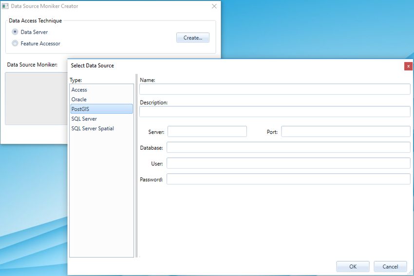
February 13, 2018 16New Technology DATABASE UTILITIES Support has been added for GeoPackage warehouses. BATCH PUBLISHING FOR POSTGIS PostGIS warehouses are now supported for batch feature cache publishing through the DataSourceMonikerCreator.exe and PublishIFC.exe utilities. This also means that PostGIS warehouses are available for shared/enterprise cache configurations. February 13, 2018 17
New Technology

GML DATA SERVER
A new read-only GML data server has been introduced with GeoMedia 16.5, replacing the previous GML data
server. It supports data conforming to the OGC Geography Markup Language (GML) specification.

February 13, 2018                                                                                         18
New Technology

Several new connection options are provided on the Advanced button.

February 13, 2018                                                                19
New Technology

Key features of this new GML data server:

   •   Improvements in the logic of parsing and translating GML structure into GeoMedia feature classes,
       resulting in broader compatibility and significantly-reduced connection time. The default strategy is to use
       the schema from the GML header to compose most of the feature classes definitions needed for
       GeoMedia at connection time. But in cases in which the schema is not available, not useful, or incorrect,
       the data server can be set to ignore the schema and try to compose the feature classes definitions directly
       from the GML structure.
   •   The NO_GEOM_CSFFOUND option available for the previous GML data server (corresponding to the “If
       no matching coordinate system is found for a feature instance” group of the “Advanced Options” dialog

February 13, 2018                                                                                               20
New Technology
box) has been retired and is ignored if passed to the ConnectInfo parameter through API. The GeoMedia
feature model does not support GML files with features of the same feature class having different
coordinate systems. The new GML data server assumes that the first feature found within a feature class
sets the coordinate system for the whole class. The benefit of this assumption is a much shorter
connection time, especially with GML having multiple feature classes.
• Overriding the coordinate system is possible for incorrectly-defined GML files. The user can input a valid
EPSG code or a CSF file, and the new coordinate system definition is applied to all feature classes from
the GML file.
• The data server will respect the axis order according to the standard EPSG or CSF definition. If the GML
file does not respect the axis order (for example files with the EPSG:4326 coordinate system in which
latitude-longitude is expected but longitude-latitude is what is provided), options for swapping the
coordinates are available.
• In cases when the schema associated with a GML file is not available, not useful (i.e. does not completely
describe the GML structure), or incorrect, the user has options for identifying a different schema file or
ignoring the schema. When ignoring the schema, the connection time increases because the data server
must read most of the GML file to discover its structure.
The data server better handles very large GML files that have produced many “out of memory” errors in the past.
When dealing with large files (greater than a default threshold), a disk cache is created and the memory footprint of
GeoMedia is considerably reduced. The default value for this file size limit is set at 500MB. Because performance
degrades when using a disk cache instead of memory, this setting can be increased by the user if the computer
has enough RAM to accommodate the data.
WFS DATA SERVER
A new read-only WFS data server has been introduced with GeoMedia 16.5, replacing the previous WFS Read-
Only data server. It supports data conforming to the OGC Web Feature Service (WFS) specification.
February 13, 2018 21New Technology Several new connection options are provided on the Advanced button. February 13, 2018 22
New Technology

Key features of this new WFS data server:

   •   It provides the same advanced GML parsing and translation logic as the GML data server, for extensive
       compatibility with different WFS services.
   •   It includes a new connection dialog for setting the coordinate systems associated with feature classes, so
       INI files and the NOCSFFOUND connection option of the previous WFS Read-Only data server
       (corresponding to the “If no matching coordinate system is found for a feature class” group of the
       “Advanced Options” dialog box) are no longer necessary.
   •   The user can select which feature classes are visible in GeoMedia. This is useful when only certain
       classes are needed from a WFS service, and it results in shorter connection times. This also can be used
       to filter incorrectly-defined feature classes that could cause errors in operation.
   •   The HTTP request timeout can be increased for slower internet connections or for older WFS services not
       supporting paging operations for transferring data.

February 13, 2018                                                                                              23
New Technology
DEFINE WAREHOUSE CONFIGURATION FILE UTILITY
This utility no longer offers the ability to define or edit INI files for the WFS Read-Only data server. The new WFS
data server offers the convenience of connection parameters provided exclusively within the connection syntax,
with no external file required.
DATA CAPTURE
SELECT SET PROPERTIES
The Select Set Properties command now remembers the position, size, and column widths of the dialog across
sessions.
OFFLINE EDITING
The commands Output to Offline and Post from Offline now support GeoPackage warehouses as the offline
connection.
SPATIAL MODELING
SPATIAL MODEL EDITOR
This utility has been upgraded to the latest version released with ERDAS IMAGINE 16.5.
NEW OPERATORS
New operators have been introduced for performing geoprocessing on feature data, which are borne out of certain
GeoMedia capabilities. These are found in the new Feature Analysis and Geometry Creation operator categories,
and include:
• Generate Functional Attributes and Define Functional Attribute operators, analogous to the Functional
Attributes command and corresponding pipe.
• Intersect Features operator, analogous to the Spatial Intersection command and corresponding pipe.
• Mask Features operator, analogous to the Spatial Difference command and corresponding pipe.
• Merge Features operator, analogous to the Analytical Merge command and corresponding pipe. This
operator replaces an earlier operator implementation by the same name, which had limited capabilities.
• Create Centroid and Create Centerpoint operators, providing efficient access to these capabilities also
provided through the Generate Functional Attributes operator.
February 13, 2018 24New Technology
EXPRESSIONS WITHIN OPERATORS
For those operators which use functional attributes (Generate Functional Attributes and Merge Features), there are
additional expression functions beyond those available in GeoMedia. Those operators, listed by function category,
are:
• Geometry
o BUFFERRING – returns a buffer ring from and to certain distances from the given geometry
o BUFFERZONE – returns a buffer zone at a certain distance from the given geometry
o CONVEXHULL – returns the convex hull of the given geometry
o FITTEDBOUNDINGBOX – like the MBR function, but with the box oriented to optimally fit the data
o STROKE – returns a polyline geometry with any input arcs stroked at 5-degree intervals
• Math & Trig – these are the hyperbolic equivalents to existing trigonometry functions
o ACOSH
o ASINH
o ATANH
o COSH
o SINH
o TANH
• Misc
o CHOOSE – provides a more compact and easily used alternative to nested IF functions
o DECODE – evaluates a set of conditions and returns the first condition evaluated to true
o SPLIT – splits a text string into multiple text strings using a given delimiter
o TOP – returns the top (highest) n values from a set of values
February 13, 2018 25New Technology
For the most part, the expression syntax used in these new Feature Analysis operators matches that of GeoMedia,
which permits direct use in Spatial Modeler of expressions from GeoMedia functional attribute definitions.
However there is not 100% compatibility, so be aware of these differences:
• It is necessary to explicitly cast content instead of counting on an implicit cast, because of internal
technology changes and because of the possibility of data loss occurring without user awareness when an
implicit cast is performed.
• The STATUS function is not provided, it has no role to play in the spatial modeling context.
• The FORMATATTRIBUTE function is not provided, attributes do not have metadata for display formatting
in the spatial modeling context.
• The LOOKUP function has moved from the Statistical function category to Misc.
ENHANCEMENTS TO EXISTING OPERATORS
Features Input operator is enhanced to support PostGIS databases.
February 13, 2018 26New Technology Features Database Output operator is enhanced to support PostGIS databases. Preview operator is enhanced to support Vector geometry fields (called Compound geometry fields in GeoMedia). OTHER NEW OPERATORS Numerous other new operators have been introduced beyond those mentioned above that are analogous to GeoMedia functionality. Many come from an ERDAS IMAGINE heritage, and include operators for processing many types of data – raster, feature, point cloud, and more. For more information see Spatial Modeler help. SAMPLE SPATIAL MODELS The model “BufferAndMerge” has been altered to employ the new Merge Features operator. February 13, 2018 27
New Technology

GEOMEDIA IMAGE PROFESSIONAL

IMAGE LIGHT TABLE PLUS 2018
Image Light Table Plus 2018 has been integrated with this release of GeoMedia Image Professional. Image Light
Table Plus 2018 includes the following new and enhanced features:

New Radar/SAR Improvements

   •   Logarithmic display option for DRA/Histogram tool window
   •   Persist SAR metadata when saving to NITF
   •   Sentinel-1 support

New Geo Accuracy Improvements

   •   Common Sensor Model (CSM) support
   •   Geography Markup Language (GML) support
   •   NITF-embedded elevation data support

Display and Performance Improvements

   •   Softcopy Image Processing Standard (SIPS) support
   •   Enhanced platform/context-specific default display settings
   •   Optional antialiasing during reduced resolution creation
   •   Support for new Sharpen and TTC families and members
   •   High resolution display improvements

New and Improved Data Formats

   •   DIMAP V2 image tiling support
   •   KOMPSAT-3 support
   •   KOMPSAT-3A support
   •   Sentinel-1 support

Usability

   •   Apply DRA based on Regions of Interest
   •   Ability to reset Don't Show Again warning dialogs
   •   Explanded File Open Preview dialog image metadata
   •   Optionally create reduced resolutions during save
   •   NITF File and Image subheader metadata display

GEOMEDIA GEODEX
None

February 13, 2018                                                                                           28
System Requirements
GEOMEDIA 3D
SAVE AND LOAD IMPORT 3D OBJECTS SETTINGS
The ability has been added in the Import 3D Objects command to persist (in user-definable XML files) the settings
used for the command.
PREDEFINED STYLES
GeoMedia 3D now delivers a set of predefined styles.
FIRST PERSON VIEW
The First Person View enables a navigation mode that simulates a walk through the 3D scene. It displays what a
person would see when turning around, looking up or down, or walking straight ahead. A new slider is also
provided to allow dynamic adjustment of the field of view value.
LATIN-1 (ISO-8859-1) CHARACTER ENCODING
The ability has been added in the Import 3D Objects command to use alternate Latin-1 (ISO-8859-1) character
encoding during model file parsing rather than the default UTF-8 encoding.
LOCAL ORIGIN DEFINITION FOR TRIMBLE SKETCHUP FILES
The ability has been added in the Import 3D Objects command to define the local origin latitude and longitude
values when the embedded origin is missing from a Trimble SketchUp Model file (1-K1PFTD).
DEFINE COORDINATE SYSTEM FOR HEXAGON POINT CLOUDS
Hexagon Point Cloud (HPC) files should be encoded with proper coordinate system metadata. However, in cases
where such files do not contain this metadata, the Insert HPC Footprints command now allows the user to define
a coordinate system (1-XNRVQ6).
SYSTEM REQUIREMENTS
Computer/ Processor Minimum 4 core Intel 64 or equivalent, 8 core or more recommended
4 GB (dual channel systems) or 6 GB (triple channel systems) minimum, 8 GB (dual channel
Memory (RAM)
systems) or 12 GB (triple channel systems) or more recommended
4 GB for software
Disk Space
Data storage requirements vary by mapping project1
February 13, 2018 29System Requirements
Minimum display resolution 1600 x 1200. 4K Ultra HD monitors are not currently supported.
LCDSystem Requirements
SQL Server® 2017 Express
PostgreSQL 9.3 with PostGIS 2.1
PostgreSQL 9.4 with PostGIS 2.2
PostgreSQL 9.6 with PostGIS 2.3
Oracle Client 11g, 32-bit5
Oracle Client 12.1, 32-bit5
Database Client Engines
Oracle Client 12.2, 32-bit5
SQL Server Native Client 10.0 or higher6
SYSTEM REQUIREMENTS NOTES
1Disk I/O is usually the slowest task in geospatial data processing. Faster hard disks improve productivity.
Reading data from one disk, writing temporary data to a second disk, and writing data to a third disk improves
performance. Disk arrays improve productivity but some RAID options slow performance. Network disk drives are
subject to network limitations.
232-bit versions of the Windows operating systems are not supported. Image Scout runs on 64-bit systems in 32-
bit emulation mode.
3 Required for GeoMedia 3D only. For information on installing .NET Framework 3.5 for Windows 10, see the
Installing .NET Framework 3.5 (Windows 10 only) section in the GeoMedia 3D Installation Guide.
4To install, right-click on \Repository\Image Scout\GM 3D\Prerequisites\vs_piaredist.exe and select
Run as administrator.
5 Oracle Data Access Components (ODAC) is required if using the Feature Accessor option for Oracle in the
PublishIFC utility, or if using the Database Utilities utility to manage an Oracle warehouse. ODAC is normally
delivered by the Oracle Client Administrator installer, but not by the Oracle InstantClient installer. ODAC contains
many components, of which PublishIFC requires the Oracle Data Provider for .NET, and Database Utilities
requires the Oracle Provider for OLEDB.
6 The SQL Server Native Client 10.0 or higher is needed in order for the Database Utilities utility to automatically
create the correct GeoMedia metadata for date, time, and datetime2 data types when using a SQL Server or SQL
Server Spatial warehouse. You may get SQL Server Native Client 10.0 or higher from the corresponding Microsoft
websites. If the SQL Server Native Client is not installed on the system, you will need to manually choose Date as
the data type from the dropdown combo box for these data types in the Feature Class Properties dialog and set
the format properly.
February 13, 2018 31Issues Resolved
ISSUES RESOLVED
GEOMEDIA PROFESSIONAL
ISSUES RESOLVED (GEOMEDIA 16.1)
CR # SUMMARY Description / How to Reproduce
Intersection does Using offset when digitizing with the Intersection snap enabled does not work with the construction lines
not work with offset displayed for the offset.
temporary
construction lines. Steps to reproduce.
86726 1. Open the IntersectionSnap.gws and correct the path to the City.mdb.
_GM
2. Insert a county_street feature using an offset of 500 and select mutiple creek features to
display the construction lines.
Start digitizing and select an intersection of the construction lines and see how the Intersection snap
glyph does not appear or work.
With further investigation, this is caused by an issue in the Oracle Dataserver.
Error in GWM
1- CreateLegendEntry
LJ3K3 Graphic due to an
issue in the Oracle
P Dataserver.
GeoMedia The properties control may hang GeoMedia on certain operating systems. It has been observed that on
application may Windows 8.1 and Windows 10, that when interacting with other applications, if the user clicks on the
hang when using Cancel option on the Properties dialog then the application may hang. Specifically, the application
Properties on hangs if the control does not have focus (top highlighted in blue) when the Cancel option is selected.
Windows 8.1 or
Windows 10. Workflow (Windows 10):
1- 1. Start the GeoMedia application, with features displayed in map window (USSampledata.gws
LI3G2 for example).
M 2. Start a secondary application such as Process Monitor.
3. In GeoMedia Map Window, double-click graphic feature to invoke Properties dialog.
4. Click on the secondary application to make it active (leaving Properties dialog open in GM).
Click the Close option on the Properties control (without giving focus to control).
For GM Map GeoMedia Desktop 16.00.0000.01405 and GeoMedia Map Publisher 16.00.0000.00012
1- Publisher, the
QNNZ queued edit Map There is an issue with the displayed results appearing in the Queued Edit Map Window, specifically:
Window is not
K5 displaying 1. The original geometry is not displaying in the Queued Edit Map Window.
February 13, 2018 32Issues Resolved
Generalize Results 2. The CDRGeometry (conflict reference geometry) is not displayed in the Queued Edit Map
correctly. Window.
The conflict geometry and original geometry are not appearing as dashes.
CAD data server An SR was filed asking for assistance in serving the Text geometry that is associated with TAGS from
fails to serve an AutoCAD Block (as is displayed in AutoCAD itself). However based on testing thus far this doesn’t
TextPointGeometry appear to be possible despite the fact that the ‘AutoCAD Scanner Design Specification’ document
1- for AutoCAD TAGs indicates that the TAG type should be mapped to TextPointGeometry.
(block attributes).
QRXT Specifically the Native-to-GDO Geometry Type Mapping table in the ‘AutoCAD Scanner Design
3F Specification’ document shows the Native Geometry Type of ‘TAG’ (described as “Attributes that are
attached to block entities in the drawing file.”) mapped to the GDO Geometry Type of
‘TextPointGeometry’. However attempts to serve the TAG attributes from the customer provided dwg
file as text results in 0 geometries for the TextGeometry legend entry.
Copy Parallel > Copy Parallel > Snap to point doesn't place line on point.
Snap to point
doesn't place line Try to copy an Interstate through a city out of USSample Data set.
on point.
1. Start Copy Parallel
1-
JP60JI 2. Identify Interstate for Copy Parallel
3. Snap on City point to copy parallel
The snap won't be accepted. The Interstate is not copied parallel through the citypoint, instead it is
copied in the vicinity.
OpenRecordset Opening a recordset with a combination of gdbOpenSnapshot type and any valid spatial filter results in
with an empty recordset being returned. Attached is a sample .NET application demonstrating the issue.
1- gdbOpenSnapshot
MJA88 and spatial filter
results in an empty
J recordset for
PostGIS GDO.
Select set When a Join is displayed, the user may notice incorrect select set display in the map window while
problems when join interacting with corresponding data view. The problem seems to be display only but can be confusing.
displayed. It does not occur in version 6.1 but is latent to 2014.
1- For example, the user might have the following entries on the legend:
D0B8 • States
O8
• Join of States and Counties
The user may select the record for Arizona in a States data table, but both Arizona and Utah will be
selected in the map view.
1- Shared cache Customer has created Oracle trace files that they believe indicates that the Net (Shared) caching is
appears to be slower than Local (Exclusive) caching due to parsing of query statments for indexes, views, and tables.
L7FF1 slower than The trace files created by the customer are included in the attached zip file and TKPROF file. The
D Exclusive cache problem description provided by the region as taken from the SR is shown below.
February 13, 2018 33Issues Resolved
due to query We have received a TKPROF file (GM_startup_prod.tkp) from the customer made for the startup of a
parsing. workspace (which looks directly in Oracle view), where they note that a lot of time is spent on parsing
statements that query for indexes for the various views and tables.
It accounts for a significant amount of the total startup time. If you look at the summary for non-
recursive statement at the bottom of the TKPROF file you can see that almost 24 seconds are spent
parsing.
Would it be possible to reduce time spent parsing by using bind variables?
Reverse Direction Secondary geometries are not reversed when using the Reverse Direction command from the Vector
does not work on a tab or when using the Reverse command from the Geometry Information context menu. Here is the
secondary workflow to reproduce the problem:
geometry, it
reverses the 1. Extract the attached ReverseGeometry.zip file and then open the ReverseGeometry.gws that
unselected primary has an Access connection to the ReverseGeometry.mdb file.
geometry.
a. When the .gws is opened, note that the legend contains two entries for the feature
class named LineFeature and its associated secondary geometry named
‘Geometry2 of LineFeature’. The primary geometry for the feature class is
displayed in red and the secondary geometry in blue. Additionally a style is applied
with an arrow symbol indicating the direction of each geometry.
1-
QJA89 2. Use the cursor to click on one of the secondary geometries in the map window (i.e. the red
geometry). Note that only the secondary geometry is shown in the select color (e.g. green
D highlight).
3. Now choose the Reverse Direction command from Vector > Edit on the ribbon bar. This will
result in the reversal of the primary geometry even though it was not selected, while the
secondary geometry which was selected remains unchanged. This is apparent because the
arrows for the blue primary geometry style are reversed, but the arrows for the red secondary
geometry are still pointing in the original direction.
This same behavior is observed with the Reverse command when accessed via Geometry Information.
For instance select the red secondary geometry, then choose the Geometry Information command and
right click on the ‘PolylineGeometry’ node, then choose Reverse from the displayed context menu. As
before, the primary geometry will be reversed, but the selected secondary geometry will remain “as is”.
Ghost circles Creation of a thematic mapping with color fill of polygon geometries containing small arc geometry
rendered in display components may result in color filled circles appearing in both map and layout window displays; the
when create circles change in distribution and size depending on zoom scale. The problem is not seen in version
thematic of 2015.
polygons
containing arcs See attachments for screen shot showing comparison between version 2015 and 2016. If the arcs are
(Regression). removed from the polygon geometries, the problem does not occur in version 2016.
1- Workflow using data provided in Attachments:
LRSM 1. Extract contents of .zip
RH
2. Use GeoMedia 2016 to open Version2016_Access.gws, correcting path to source
warehouse.
3. Observe small circles in the map display that change with changes in the display scale.
If review Geometry Information for some of the polygons, you can see that the geometry has arc
components; The geometry seems to pass standard Toolbox > Validate Geometry checks (no problems
are found).
February 13, 2018 34Issues Resolved
If the arcs are removed the problem does not occur.
Unable to display Unable to display (.ecw) layers from ERDAS Apollo WMTS service that can be displayed successfully
(.ecw) WMTS in other applications.
layers that can be
displayed The GeoMedia WMTS data server is unable to display certain layers from the ERDAS Apollo Essentials
successfully in WMTS service. The same layers can be displayed successfully in other clients using the same
other applications. coordinate system (either EPSG:4326 or EPSG:3857).
The layers from the service that fail to display in GeoMedia (but display in the other clients) are
‘sandiego3i_ecw’ and ‘bucuresti_ecw’.
To reproduce the problem, use the steps below.
1-
1. Start GeoMedia and make a new WMTS connection.:
M17EF
A 2. Use Add Legend Entries to add ‘sandiego3i_ecw’ to the legend. A legend entry will be
created with geometry statistics showing one instance.
3. If you fit the view and click the map window you can see the layer footprint highlighted, but
there is no image/tiles displayed within the footprint.
The coordinate system used in all of the clients was the same (EPSG:4326).
* Note that the ‘sandiego3i_jp2’ and ‘‘sandiego3i_otdf’ layers from the same service can be displayed
successfully in GeoMedia . These layers appear to be the same as the ‘sandiego3i_ecw’ with
presumably a different format for the source imagery (i.e. JPEG 2000 and OTDF respectively). This
means that the problem appears to be specific the ECW format.
WMTS data server The GeoMedia WMTS data server serves the ‘MAPA TOPOGRAFICZNA’ feature class from the WMTS
requests/displays service with the wrong coordinate system. Specifically the GetTile requests uses the EPSG:4326
data in wrong TileMatrixSet instead of the default EPSG:2180 TileMatrixSet.
coordinate system
(other clients work The EPSG:2180 TileMatrixSet appears to be the default since it is the first listed in the GetCapabilities
correctly). document and GeoMedia will even show that the coordinate system assigned to the ‘MAPA
TOPOGRAFICZNA’ feature class is EPSG:2180 after it is served using the WMTS data server.
1- There appears to be a disconnect between the metadata in that Feature Class Definition indicates that
the coordinate system is EPSG:2180 and the actual feature class served which seems to be
M8DCI EPSG:4326. This problem results in an incomplete display of ‘MAPA TOPOGRAFICZNA’ feature class
D in the Map Window and the portion of the data that is visible is warped presumably due to the
coordinate system transformation from EPSG:4326 to EPSG:2180.
The same problem exists even if you use a Warehouse Configuration File (.ini) for the WMTS
connection with the following entry defining the default TileMatrixSet as EPSG:2180.
[TileMatrixSet for Feature Classes]
Default=EPSG:2180
Layout > Print/Plot Customer has 6" resolution imagery. These are uncompressed 4 band (32bit) untiled TIFF (tested with
1- > Background and without overviews) for their service area. They report that the images appear solid black when
ANAB image prints black trying to output a layout to .pdf or other printing device.
(Images with more
3S than 3 bands).
February 13, 2018 35Issues Resolved
Open GWS, connect to USSampleData or a blank Access connection. Insert the two Geotiffs. Print to
PDF (Used PDF995 locally) and outputs are black for the images. Also tested with Adobe Acrobat 10
and the local hard copy devices.
Workaround is to give the image feature class (or any feature class displayed on legend) a 1%
translucency. The image plots, looks great.
This is not specific to TIFF images, seen with JFIF and other formats as well.
This is apparently a problem common to all 4-sample-per-pixel data.
Errors occur with The PostGIS data server in GeoMedia 2016 does not correctly handle feature class/table names that
multiple commands contain uppercase letters, resulting in errors. This issue was reported by a customer who states that
1- when using the open source PostGIS data server that could be used with GeoMedia 2015 did not have this
M2V06 PostGIS table problem.
names containing
J uppercase
characters.
Layout - Text There is a failure when displaying OpenType fonts in GeoMedia 2013. Support replicated failure on
Placement and both GeoMedia 6.2 and Geomedia 2014.
Text Properties >
Support for In versions of GeoMedia prior to 6.1 (5.2, 6.0), this .otf font was available in the drop- down list for text
OpenType (.otf) placement in the Layout Window, and the text was displayed with the proper font. But starting in the
fonts is missing. 6.1 version, the fonts does not show up in the drop- down list - they are not available for placing new
text in the layout window.
In versions since 5.2 (5.2, 6.0, 6.1, 2013, 2014) right click on selected layout text and then 'Properties'
1- shows the text properties dialog. In the sample .gws, note that the customer's font is the StencilStd.otf,
95FG and that it displays with bright green color, indicating a non-supported font.. Also note that newly
placed text in a new, blank .gws can also be given the StencilStd.otf font, but that the layout window
MS does not display the text with this font properly - text appears bright green.
Thus there are two parts to this issue. One is a regression from 6.0 GeoMedia to later versions – you
can no longer place or display layout text with .otf fonts. The second part is that if the regression was
an intentional change in the product, one should not be able to select .otf font from the layout Text
Properties dialog.
Both parts are resolved if we restore the previous functionality, placement and display of layout text with
OpenType fonts.
Originating Pipe Opening a recordset through an originating pipe will cause it to check the registry for CacheEnabled
recordset setting for the specific connection type. However, this is accomplished by instantiating a whole new
open/reopen GDOServerRegEntries object that enumerates the whole HKLM\Software\Wow6432Node\GDO registry
1- spams registry for subkey and parses values therein.
GDO configuration.
SMHS The function using the GDOServerRegEntries is: GMConnection::GetCacheFileName, which it does
UB even if the given connection is created without explicitly enabling caching.
This causes a registry contention in an environment when multiple concurrent GDO requests are being
served, like in a WebMap installation.
1- Using WMTS data Use of the WMTS data server results in GeoMedia hanging (where there is no response to any mouse
LUTZ6 server hangs click), thus forcing the GeoMedia process to be killed via Task Manager. This problem seems to occur
GeoMedia forcing
G the GeoMedia
February 13, 2018 36You can also read