From Smart Farming towards Agriculture 5.0: A Review on Crop Data Management - MDPI
←
→
Page content transcription
If your browser does not render page correctly, please read the page content below
agronomy
Review
From Smart Farming towards Agriculture 5.0:
A Review on Crop Data Management
Verónica Saiz-Rubio *        and Francisco Rovira-Más
 Agricultural Robotics Laboratory (ARL), Universitat Politècnica de València, Camino de Vera,
 s/n. 46022 Valencia, Spain; frovira@dmta.upv.es
 * Correspondence: vesairu@upv.es; Tel.: +34-963-877-291

 Received: 2 December 2019; Accepted: 17 January 2020; Published: 3 February 2020

 Abstract: The information that crops offer is turned into profitable decisions only when efficiently
 managed. Current advances in data management are making Smart Farming grow exponentially
 as data have become the key element in modern agriculture to help producers with critical
 decision-making. Valuable advantages appear with objective information acquired through sensors
 with the aim of maximizing productivity and sustainability. This kind of data-based managed farms
 rely on data that can increase efficiency by avoiding the misuse of resources and the pollution of
 the environment. Data-driven agriculture, with the help of robotic solutions incorporating artificial
 intelligent techniques, sets the grounds for the sustainable agriculture of the future. This paper
 reviews the current status of advanced farm management systems by revisiting each crucial step,
 from data acquisition in crop fields to variable rate applications, so that growers can make optimized
 decisions to save money while protecting the environment and transforming how food will be
 produced to sustainably match the forthcoming population growth.

 Keywords: agriculture 4.0; big data; farm management information system (FMIS); robotics; IoT;
 variable-rate technology (VRT); AI

1. Introduction
      The agriculture sector is undergoing a transformation driven by new technologies, which seems
very promising as it will enable this primary sector to move to the next level of farm productivity
and profitability [1]. Precision Agriculture, which consist of applying inputs (what is needed) when
and where is needed, has become the third wave of the modern agriculture revolution (the first was
mechanization and the second the green revolution with its genetic modification [2]), and nowadays,
it is being enhanced with an increase of farm knowledge systems due to the availability of larger
amounts of data. The United States Department of Agriculture (USDA) already reported in October
2016 that Precision Agriculture technologies increased net returns and operating profits [3]. Also,
when considering the environment, new technologies are increasingly being applied in the farms
to maintain the sustainability of farm production. However, the adoption of these technologies
involves uncertainty and trade-offs. According to a market analysis, the factors that would facilitate
the adoption of sustainable farming technologies include better education and training of farmers,
sharing of information, easy availability of financial resources, and increasing consumer demand
for organic food [4]. When applying these new technologies, the challenge for retrieving data from
crops is to come out with something coherent and valuable, because data themselves are not useful,
just numbers or images. Farms that decide to be technology-driven in some way, show valuable
advantages, such us saving money and work, having an increased production or a reduction of costs
with minimal effort, and producing quality food with more environmentally friendly practices [5].
However, taking these advantages to the farm will depend, not only on the willingness of producers

Agronomy 2020, 10, 207; doi:10.3390/agronomy10020207                          www.mdpi.com/journal/agronomy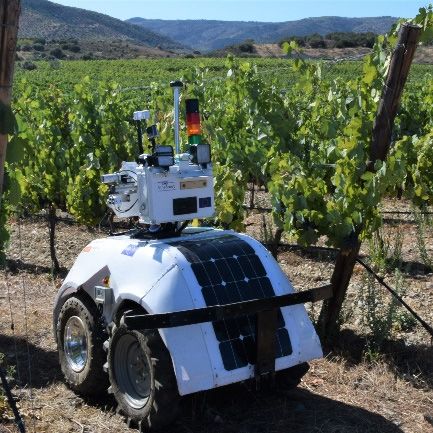
Agronomy 2020, 10, 207                                                                               2 of 21

for adopting new technologies in their fields, but also on each specific farm potential in terms of scale
economies, as profit margin increases with farm size. The USDA reported that, on average, corn
farm operating profit of Precision Agriculture adopters was 163 dollars per hectare higher than for
non-adopters, taking into account that the highest adoption rates for three technologies (computer
mapping, guidance, and variable-rate equipment) were on farms over 1500 hectares [3]. Such margins
can even go up to 272 dollars depending on the crop. A greater use of Smart Farming services is vital
to not only improving a farm’s financial performance, but also to meet the food needs of an expanding
population [6].
      The final purpose of this paper is to demonstrate how making decisions with the modern
data-based agriculture available today can lead to sustainable and profitable actuation to nourish
people while reducing harm to the environment. In order to evaluate how modern agriculture can help
in a sustainable decision-making process, this article revisits the main steps of an information-based
agriculture and focuses on data management systems by reviewing recent applications related to each
crucial step, from data acquisition in crop fields to the execution of tasks with variable rate equipment.

2. Data-Driven Agriculture: Agriculture 4.0
      This new philosophy centered on agricultural data has been expressed with several names:
Agriculture 4.0, Digital Farming, or Smart Farming, and was born when telematics and data management
were combined to the already known concept of Precision Agriculture, improving the accuracy of
operations [7]. As a result, Agriculture 4.0 is based on Precision Agriculture principles with producers
using systems that generate data in their farms, which will be processed in such a way to make proper
strategical and operational decisions. Traditionally, farmers have gone to the fields to check the status
of their crops and make decisions based on their accumulated experience. This approach is no longer
sustainable as, among other reasons, some fields are too large to be efficiently managed according to
the threefold criteria that will lead the coming years: Efficiency, sustainability and availability (for
people). Advanced management systems within the context of Smart Farming are providing practical
solutions. Also, despite some farmers have a long-time experience gathered after many years of work
in the field, technology may provide a systematic tool to detect unforeseen problems hard to notice
by visual inspection on occasional checks. Regarding the willingness of adopting modern tools in
agriculture, young farmers show a more positive attitude than elder ones, as the former can support
their not-so-large experience in the field with new smart tools providing key information. However,
the average age of farmers in the last decades has been alarmingly increasing: Around 58 years old in
the USA and Europe, 60 in sub-Saharan Africa, or 63 in Japan [8,9]. Fortunately, this trend is expected
to change. Several European policies, for example, are being set to support a generational renewal,
facilitating access to initial investment, loans, business advice, and training [9]. A generational renewal
in a rural development context goes beyond a reduction in the average age of farmers; it is also about
empowering a new generation of highly qualified young farmers to bring the full benefits of technology
in order to support sustainable farming practices [10]. This implies that young farmers will need to
transform the existing land to more modern and competitive farms with the purpose of maintaining
viable food production while improving the competitiveness of the agrifood chain, because with
advanced technologies and new thinking, young people can transform the agricultural sector [8].

2.1. Internet of Things: Collecting Information
     Internet of things (IoT) in an agricultural context refers to the use of sensors and other devices to
turn every element and action involved in farming into data. It has been reported that an estimation
of a 10% to 15% of US farmers are using IoT solutions on the farm across 1200 million hectares and
250,000 farms [11]. IoT drives Agriculture 4.0 [12]; in fact, IoT technologies is one of the reasons why
agriculture can generate such a big amount of valuable information, and the agriculture sector is
expected to be highly influenced by the advances in these technologies [13]. It is estimated that, with
new techniques, the IoT has the potential to increase agricultural productivity by 70% by 2050 [14],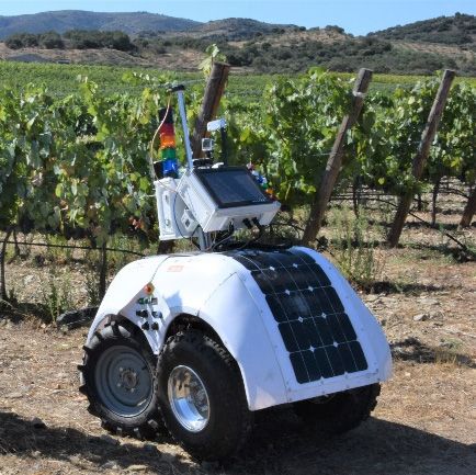
Agronomy 2020, 10, 207                                                                               3 of 21

which is positive, because according to Myklevy et al., the world needs to increase global food
production by 60% by 2050 due to a population growth over nine thousand million [15]. The main
advantages of the use of IoT are achieving higher crop yields and less cost. For example, studies from
OnFarm found that for an average farm using IoT, yield rises by 1.75% and energy costs drop 17 to
32 dollars per hectare, while water use for irrigation falls by 8% [12].

2.2. Big Data: Analysis of Massive Data
     In the current technology-based era, the concept of big data is present in many economic sectors,
but is it already available to agriculture? The ever-growing amount of data available for field
management makes necessary the implementation of some type of automatic process to extract
operational information from bulk data. However, the volume of data currently retrieved from most
commercial fields is, arguably, not yet at the level considered to be classified as big data. According to
Manyica et al. [16], big data has three dimensions: Volume, velocity, and variety. Kunisch [17] added a
fourth V for veracity. Finally, a fifth V was added by Chi et al. for the extra dimension valorization [18].
Overall, the five V (dimensions) of big data stand for:

•    Volume refers to datasets whose size is beyond the ability of typical database software tools to
     capture, store, manage, and analyze information. This definition includes an estimate of how big
     a dataset needs to be in order to be considered big, and it can vary by study sector, depending on
     software tools that are commonly available and common sizes of datasets, typically starting in the
     terabyte range [16].
•    Velocity refers to the capability to acquire, understand and interpret events as they occur.
     In agriculture, this would refer to applications that occur in real time, like data being processed
     right in the field to apply variable rates of chemicals in equipment featuring variable rate
     application technologies.
•    Variety refers to the different data formats (videos, text, voice), and the diverse degrees of
     complexity. This situation is not strange in agriculture when different data sources are used to
     work in complex scenarios such as images and soil or weather probes.
•    Veracity refers to the quality, reliability, and overall confidence of the data.
•    Valorization is the ability to propagate knowledge, appreciation and innovation [18].

     In the context of crop management, Kunisch [17] concluded that big data is applicable only in
some cases in agriculture, depending on each farm and its level of technology adoption. Nevertheless,
the Proagrica [19] report confirmed that big data was being increasingly applied in the agriculture
sector. Kamilaris et al. [18] cited 34 works where big data was used in agricultural applications, and
Wolfert et al. [20] published a review on big data applications in Smart Farming. In line with this
trend, the Consortium of International Agricultural Research Centers (CGIAR, Montpellier, France)
created a Platform for Big Data in Agriculture with the purpose of using big data approaches to solve
agricultural development problems faster, better, and at a greater scale than before [21].

2.3. Agriculture 5.0: Robotics and Artificial Intelligence (AI) to Help in Nourishing People
     Big engineering challenges typically spur big solutions through disruptive technologies,
and Agriculture 5.0 is probably the one for the first half of the 21st Century. The concept Agriculture
5.0 implies that farms are following Precision Agriculture principles and using equipment that involves
unmanned operations and autonomous decision support systems. Thus, Agriculture 5.0 implies the use
of robots and some forms of AI [22]. By tradition, farms have needed many workers, mostly seasonal,
to harvest crops and keep farms productive. However, society has moved away from being an agrarian
society with large quantities of people living in farms to people living in cities now; as a result, farms
are facing the challenge of a workforce shortage. One solution to help with this shortage of workers is
agricultural robots integrating AI features. According to a Forbes study [23], farm robots augment
the human labor workforce and can harvest crops at a higher volume and faster pace than human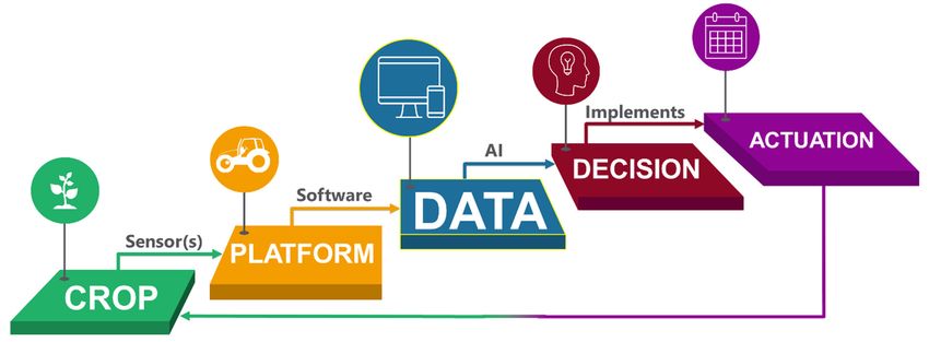
Agronomy 2020, 10, 207                                                                                 4 of 21

laborers. Although there are still many cases in which robots are not as fast as humans, agriculture is
currently developing robotic systems to work in the field and help producers with tedious tasks [24–27],
pushing agricultural systems to the new concept of Agriculture 5.0. According to Reddy et al. [28],
the advent of robots in agriculture drastically increased the productivity in several countries and
reduced the farm operating costs. As said before, robotic applications for agriculture are growing
exponentially [27], which offers promising solutions for Smart Farming in handling labor shortage and
a long-time declining profitability; however, like most innovations, there exist important limitations
to cope with at the current early stages. These technologies are still too expensive for most farmers,
especially those with small farms [29], because scale economics make small individual farms less
profitable [30]. Nevertheless, the cost of technology decreases with time, and agricultural robots will be
surely implemented in the future as the alternative to bring about higher production [4,31]. The world
agricultural production and crop yields slowed down in 2015. The concept of agricultural robotics
was introduced to overcome these problems and satisfy the rising demand for high yields. Robotic
innovations are giving a boost to the global agriculture and crop production market, as according to
the Verified Market Intelligence report, agricultural robots will be capable of completing field tasks
with greater efficiency as compared to the farmers [32].
     Agricultural tech startups have raised over 800 million dollars in the last five years [31]. Startups
using robotics and machine learning to solve problems in agriculture started gaining momentum in
2014, in line with a rising interest in AI [33]. In fact, venture capital funding in AI has increased by 450%
in the last 5 years [34]. This kind of new agriculture pretends to do more with less, because nourishing
people while increasing production sustainably and taking care of the environment will be crucial in
the coming years, as the Food and Agriculture Organization of the United Nations (FAO) estimates
that, in 2050, there will be a world population of 9.6 billion [35]. Advanced sensing technologies in
agriculture can help to meet the challenge; they provide detailed information on soil, crop status,
and environmental conditions to allow precise applications of phytosanitary products, resulting in a
reduced used of herbicides and pesticides, improved water use efficiency and increased crop yield and
quality [2].

3. Data-Driven Management for Advanced Farming: Principal Stages
      The raw measurements of key parameters from crops need to be efficiently processed so that
numbers or images unambiguously turn into valuable information. Crop management based on field
data already evolved when Precision Agriculture came to light thirty years ago, but it has certainly
been transformed by the present digital information era. Traditionally, and in those places where
technology has not arrived yet, field management consists of visually inspecting the development of
crops to reach a diagnosis with which farmers make decisions and actuate giving different treatments
to their crops. This approach relies on field experience and the information perceived through the
eyes of farmers. Additionally, associated growers can follow the recommendations of cooperative
technicians or engineers hired by the society they belong to. In farms where advanced technology
has been implemented, field management varies according to the operating cycle shown in Figure 1.
This management system based on objective field data and smart decision-making starts with the actual
crop to manage, taking advantage of its inner variability, both spatial-wise and time-wise. The platform
refers to the physical means with which information is acquired, being the sensors the specific elements
through which objective data are obtained. Data includes the information directly retrieved from the
parameters measured from the crop, soil, or ambient. Retrieving the data from the sensors can be done
in multiple ways, from inserting a pen drive in a USB port to get the files [36] to retrieving data from
software applications synchronized to the Internet. The nexus between the data and the decision stage
involves filtering routines and AI algorithms for getting only the right data and helping the grower
make correct decisions. Finally, actuation refers to the physical execution of an action commanded by
the decision system, and is typically carried out by advanced equipment that can receive orders from
a computerized control unit. As each action takes place over the crop, the cycle starts and closes at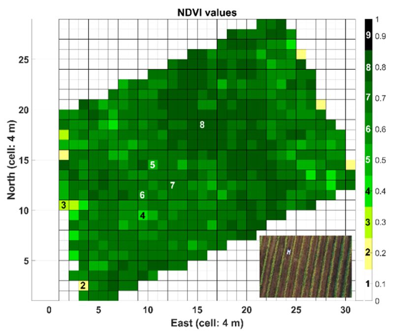
Agronomy 2020, 10, 207 5 of 21
crop level; the response of the crop is then registered by specialized sensors and the loop continues
systematically until harvesting time, which marks the end of the crop life cycle.
Agronomy 2020, 10, x FOR PEER REVIEW 5 of 21
Agronomy 2020,
Agronomy 2020, 10,
10, xx FOR
FOR PEER
PEER REVIEW
REVIEW 5 of
of 21
21
Agronomy 2020, 10, x FOR PEER REVIEW 55 of 21
Agronomy 2020, 10, x FOR PEER REVIEW 5 of 21
Figure 1. Information-based management cycle for advanced agriculture.
The following
Tableparagraphs andofFigure
1. Classification 1 explain
the research thereferenced
articles cycle thatinembodies
the presentastudy.
general data-driven
management system for advanced agriculture, including representative examples for each stage.
Category Subcategory References
Table 1 classifies the scientific works referenced in this study into the different categories of Figure 1.
CROP FigurePrecision
Figure 1. and Smart Farming
1. Information-based
Information-based management cycle
management for[2,4,7,29,35,37–40]
cycle for advanced agriculture.
advanced agriculture.
Figure 1. Information-based
Social and economic impact management cycle for advanced agriculture.
[3,5,6,8–11,31]
Table 1. Classification of the research articles referenced in the present study.
Table 1.
Table Management
1. Classification
Classification of zones
of the
the research
research articles
articles referenced
referenced in [38,41–43]
in the
the present
present study.
study.
PLATFORM Table
Category 1. Classification of
Remote sensingSubcategory the research
(satellite and articles referenced in the present study.
References
Category
Category Subcategory
Subcategory [44–46]References
References
aircraft)
Category
CROP Proximal sensing Precision
Precision andandSmart
Subcategory
SmartFarming
Farming [2,4,7,29,35,37–40]References
[2,4,7,29,35,37–40]
CROP
CROP Precision and Smart
(ground Farming
vehicles) [2,4,7,29,35,37–40]
[24–28,36,45–63]
CROP Precision
Social
Social andand and Smartimpact
economic
economic Farming
impact [2,4,7,29,35,37–40]
[3,5,6,8–11,31][3,5,6,8–11,31]
Social
Big dataand economic impact [3,5,6,8–11,31]
[1,16–21,30,32]
DATA Social and economic
Management zones impact [3,5,6,8–11,31]
[38,41–43]
Internet of Management
Things (IoT)zones
Management zones [12–14,64]
[38,41–43] [38,41–43]
PLATFORM Remote sensing (satellite
Management zones and [38,41–43]
PLATFORM
PLATFORM Remote Remote
Mapping
sensing sensing (satellite
(satellite and
and aircraft) [42,65–69] [44–46]
[44–46] [44–46]
PLATFORM Remote aircraft)
sensing (satellite and
Information Systems aircraft)(GIS, FMIS) [64,70–80] [44–46]
Proximal
Proximal sensing
sensing (ground
(ground
aircraft) vehicles)
vehicles) [24–28,36,45–63]
[24–28,36,45–63]
DECISION Proximal
Artificial sensing (AI)
Intelligence (ground vehicles) [24–28,36,45–63]
[22,23,33,34,81]
Proximal sensingBigBig data
(ground
data
Big data vehicles) [1,16–21,30,32]
[24–28,36,45–63]
[1,16–21,30,32]
[1,16–21,30,32]
DATA
DATA
DATA Decision Support Internet Big
of
Systems data
Things (IoT)
(DSS)(IoT) [1,16–21,30,32]
[77,82–90][12–14,64]
DATA Internet
Internet ofof Things
Things (IoT) [12–14,64] [12–14,64]
InternetMapping
of Things (IoT) [12–14,64]
[42,65–69]
Mapping [42,65–69]
ACTUATION Mapping
Mapping
Information Systems (GIS, FMIS) [42,65–69] [42,65–69]
[64,70–80]
Information Systems (GIS, FMIS) [64,70–80]
DECISION Variable Rate Applications
Artificial
Information
Information Systems
Systems (VRA)
Intelligence
(GIS,
(GIS, (AI)
FMIS)
FMIS) [91–93]
[64,70–80] [22,23,33,34,81]
[64,70–80]
DECISION Artificial Intelligence (AI) [22,23,33,34,81]
DECISION
DECISION Artificial Intelligence (AI) [22,23,33,34,81]
Artificial Intelligence
Decision Support Systems (DSS)(AI) [22,23,33,34,81] [77,82–90]
Decision Support Systems (DSS) [77,82–90]
3.1. Stage I: The ACTUATION
Crop as the Beginning Decision
and End Support Systems
of the Systems
Agricultural (DSS) [77,82–90]
Decision Support (DSS)Management Cycle—Analyzing
[77,82–90]
ACTUATION
Variability ACTUATION
ACTUATION Variable Rate
Rate Applications
Applications (VRA)
(VRA) [91–93]
Variable [91–93]
Variable
Variable Rate
Rate Applications
Applications (VRA)
(VRA) [91–93]
Regardless how the crop will be managed, some degree of spatial variability is assumed for all [91–93]
fields by nature. According to Searcy [37], natural variability is influenced by weather within a
3.1.
growing3.1. Stage I: The
season Crop as the Beginning and End of theseveral
Agricultural Management Cycle—Analyzing
StageandI: The from
Cropyear to Beginning
as the year; then, data
and Endfrom
of the Agricultural years Management
may be needed to determine
Cycle—Analyzing
3.1. 3.1.
Stage I: Stage
Variability
The
trends inVariability I:
Crop The
as Crop
the as
Beginningthe Beginning
and End ofand
the End of the
Agricultural Agricultural
Management
the parameters of interest, and hence, data becomes a regular input to the farm management Management
Cycle—Analyzing Cycle—Analyzing
Variability
system. Variability
Therefore, thethenecessity ofcrop
monitoring crops comes from the existence of variability
variability,
Regardless Regardless
how how
cropthethe
will will be managed,
be managed, some some
degree degree
of spatial ofvariability
spatial is assumed isbut there
assumed
for for all
all for
is a need for Regardless
the producer howto managecrop willvariability
that be managed, in asome
feasibledegree
way, ofand
spatial
the variability
widely is assumed
accepted waywithin all
fields
fields byfields Regardless
nature. by nature. According to Searcy [37], natural variability is influenced by weather withinallaa
by nature.
According how to the
According
Searcycrop will
to
[37], be
Searcy managed,
natural [37], some
natural
variability is degree
variability
influenced of spatial
byis variability
influenced
weather withinby is assumed
weather
a growing for
to do it and
season is byfrom
fields
growingsetting
by season
year within-field
nature. According
and
toandyear; from management
then, year to to
data Searcy
year;zones.
then,Management
[37], natural
data from zones
variability
several are
is subfield
influenced
years may areas
be by that
weather
needed have
to inwithin a
determine
growing
homogeneous season
features, so from
field year
practices tofrom
year;
can
several
be then, years
data
custom-made frommay
to
be
several
each
needed
ofyears
such
tomaydetermine
areas,
trends
be resulting
needed toindetermine
a
growing
trends in
the parameters ofseason
the
interest, and
parametersand from ofyear
hence, to year;
interest,
data then,
and hence,
becomes data
datafrom
a regular becomes
inputseveral
toa the years
regular may
input
farminput be needed
to the
management farm to determine
management
system.
trends
practicaltrends
and in the parameters
cost-effective of
approach interest, and
toofPrecisionhence, data
Agriculture becomes [41]. a regular to the farm management
Therefore,system. inTherefore,
the parameters
Therefore,
the necessity
system. the
of monitoring
the of interest,
necessity
necessity crops and
comes hence,
monitoring
of monitoring from data
crops becomes
comes
the existence
crops comes aofThe
from
from regular
the
the
adoption
inputbut
existence
variability,
existence
ofof
to management
the farm
is a management
variability,
there
of but there
needbut
variability, there
zones would
system. reduce
Therefore,
is a needtofor
for the producer the cost
the
the producer
manage of fertilizing,
necessity
to manage
that variability of improve
monitoring
that
in athat crop
crops
variability
feasible way, and yields,
comes
in the reduce
from
a feasible the
widelyway, way,the usage
existence
and the
accepted ofof pesticides,
variability,
widely
waywidely but
accepted
to do itaccepted
is by there
way
isbetter
a needfarm
providewithin-field for therecords
producer to manage
that areManagement
essential variability
for sale, inanda feasible
provide and the
better information for way
setting is
toado need
it isfor
by the producer
setting
management to manage
within-field
zones. that variability
management zones.
zones arein a feasible
Management
subfield way,
areas zones
thatandare
havethe widelyareas
subfield
homogeneousaccepted way
that have
to do itdecisions
management is by setting within-field
[4]. can
According management zones. Management zones are subfield areas that have
features,to dofield
so it is by
homogeneous
homogeneous setting
practicesfeatures,within-field
features, be
so fieldtomanagement
so custom-made
field
Zhang to
practices
practices
et
canal.zones.
each
can be
[38],
be of the
such
custom-made
number
Management
custom-made areas, to to ofzones
management
each
resulting
each are
of
of subfield
such
in
such
zones
areas,
a practical
areas, areasis that
a have
resulting
and
resulting in aa
in
functionhomogeneous
of the natural
practical variability
features,
and cost-effective within
so field
approach the to
practicesfield,
canthe be size
Precision of the field
custom-made
Agriculture to and
each
[41]. Thecertain
suchmanagement
of adoption areas, of resulting
management in a
practical
factors. practical and cost-effective
If the variability is high, approach to Precision Agriculture [41]. The adoption of management
zones
zones and cost-effective
would
would reduce
reduce the the
the cost
cost
minimum
approach to size
of fertilizing,
of fertilizing, of
Precision a zone
improve
improve
is limited
Agriculture
crop
crop yields,
yields,
byreduce
[41]. the possibility
The
reduce adoption
the usage
the usage of of
of of
each
management
pesticides,
pesticides,
farmer to differentially
zones would
provide betterbetter farmmanage
reduce theregions
farm records cost
records that within
of
that are a field
fertilizing, in economic
improve
are essential
essential for crop
for sale, and logistics
yields,
sale, and reduce
and provide terms.
provide betterthe In addition
usage of
better information to
pesticides,
information for
provide for
decide the area
provide of working zones, the selection of the specific parameters
management decisions [4]. According to Zhang et al. [38], the number of management zones isfora
better farm records that are essential for sale, and to be
providetracked within
better those
information
management
zones must be carefully decisions
made early [4]. According to Zhang
in the process. et al. [38],
Rovira-Más and the number [65]
Saiz-Rubio of management
classified zones is a
crop
management
function
function of the
of thedecisions
natural
natural [4]. According
variability
variability to Zhang
within
within the
the et al.
field,
field, [38],
the
the sizethe
size of number
of fieldofand
the field
the management
and zones is a
certain management
certain management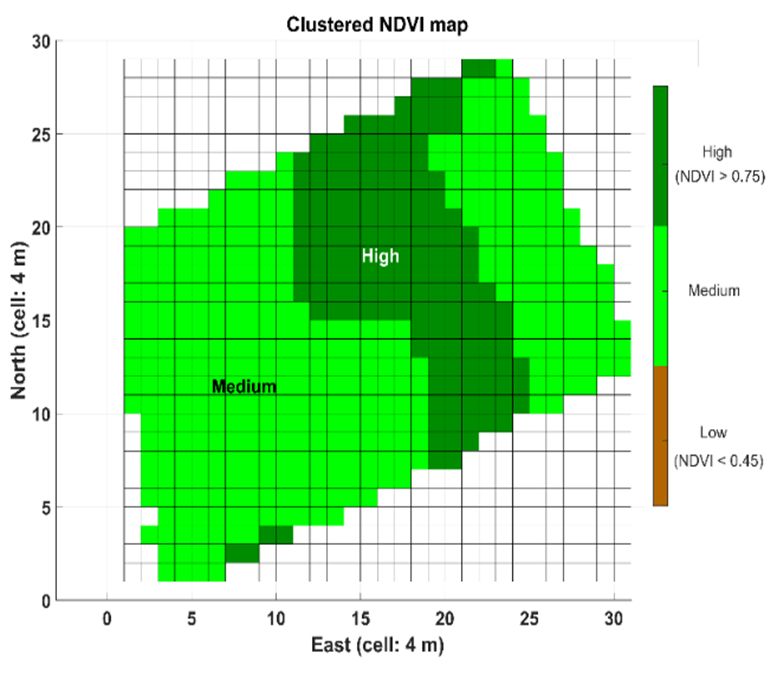
Agronomy 2020, 10, 207                                                                                6 of 21

cost-effective approach to Precision Agriculture [41]. The adoption of management zones would reduce
the cost of fertilizing, improve crop yields, reduce the usage of pesticides, provide better farm records
that are essential for sale, and provide better information for management decisions [4]. According
to Zhang et al. [38], the number of management zones is a function of the natural variability within
the field, the size of the field and certain management factors. If the variability is high, the minimum
size of a zone is limited by the possibility of each farmer to differentially manage regions within a
field in economic and logistics terms. In addition to decide the area of working zones, the selection of
the specific parameters to be tracked within those zones must be carefully made early in the process.
Rovira-Más and Saiz-Rubio [65] classified crop biometric traits in a tri-level division of crop features
depending on the focus of interest being at soil level, plant level, or produce level. This division
allowed the superimposition of various layers in a standardized map with the aim of determining a
data-based wine quality index defined as the Quality Potential Index (QPI) for each subfield area in a
vineyard. Nevertheless, there may be specific cases where the spatial variability of a field is so low that
a single mapping event can be sufficient, as reported by Klassen et al. [42] when characterizing soil
variability in rice fields.

3.2. Stage II: Platforms Supporting Sensors
      Sensors are the universal devices to monitor crops and to obtain objective information from them.
They are usually integrated in a platform, which is the general term used in Figure 1 to name the
structures where sensors are placed and carried. These platforms may be attached to off-road vehicles
or fixed to the ground within fields such as local weather stations. One of the most urgent challenges to
cope with in the next few years will be getting a wider range of non-invasive sensors able to measure
on-the-go. This approach would be closer to Agriculture 5.0, as these sensors could be attached to
autonomous platforms and robots. Nowadays, not all the parameters of interest can be measured
non-invasively and at a distance from the target; however, some technologies such as multispectral or
hyperspectral imaging are making significant improvements.

3.2.1. Remote Sensing Platforms: Satellites
     Remote sensing has played a key role in the progress of Smart Farming when field data became
generally accessible from artificial satellites. Important satellites providing agricultural information are
the American Landsat satellites (eight satellites take spectral data from the Earth each 16 to 18 days),
the European Sentinel 2 satellite system (it provides multispectral data at 10 m pixel resolution for
NDVI—Normalized Difference Vegetation Index—imagery, soil, and water cover every ten days), the
RapidEye constellation (five satellites provide multispectral RGB imagery, as well as red-edge and NIR
bands at 5 m resolution), the GeoEye-1 system (captures multispectral RGB data and NIR data at a
1.84 m resolution), and the WorldView-3 (collects multispectral data from the RGB bands including
the red-edge, two NIR bands, and 8 SWIR bands with a resolution of 1.24 m at nadir). IKONOS
and QuickBird have been already decommissioned. There exist several reviews on satellite sensing
applications, having recent studies focused on the potential applications of thermal technologies using
remote sensing [44] and nutritional status in commodity crops [45].

3.2.2. Aircraft Systems
     The distance between crops and satellites is considerable, typically around 700 km, and deeper
insights are reachable when sensors remain closer to the targets. For aircraft systems, the distance
to land can be around 100 m. For example, there is a legal limit of 120 m above the ground in Spain
for unmanned flying vehicles. Unmanned aerial vehicles (UAV) and remotely-piloted aircrafts (RPA)
can basically be of two kinds: Fixed-wing aircrafts and multirotor aircrafts. Rotary-wing UAVs are
more stable fliers as they are capable of a vertical take-off and landing; however, they are slower and
cannot cover as much area during their battery life. Fixed-wing platforms, on the other hand, can cover
more area per flight and carry larger payloads, but tend to be more expensive and break more easily
Agronomy 2020, 10, 207 7 of 21
after multiple landings [45]. When compared to remote sensing, the advantages of UAVs for Precision
Agriculture are their flexibility in frequency (revisit time of satellites) and better spatial resolutions.
When compared to ground vehicles, UAVs can get data from inaccessible places where conventional
equipment cannot stand; however, they require a professional planning of the flight route beforehand,
and certain machine vision applications may require flying at midday to avoid vegetation shadows
on the ground causing errors with imagery data. Furthermore, post processing the data and image
mosaicking is often quite challenging. An important disadvantage of UAVs is the limited payload
they can carry, which often limits the suite of sensors onboard, as well as the incapacity of flying with
strong wind.
3.2.3. Proximal Sensing: Ground Autonomous Systems—the Great Push for Agriculture 5.0
When monitoring platforms operate from the ground, the distance from the sensors to the target
crop diminishes to less than 2 m. Due to the proximity of the sensor to the plant, when data is acquired
from ground-based platforms, it is called proximal sensing. Ground vehicles are polyvalent in relation
to the payload of sensors. As these vehicles move near the crop, the data acquired increase in accuracy,
and resolutions of one or more samples per meter are feasible, being only limited by the specifications
of the particular sensors implemented. When active sensors are used, weather conditions such as
strong sunlight or poor illumination are not a serious problem anymore, and, in case of on-the-fly
processing, real-time applications are possible, as spraying weeds with the previous detection of the
pest [47]. There has been a significant impulse in the last five years for the particular case where data is
retrieved from an autonomous platform (unmanned ground vehicle or UGV) [48–52]. Aravind et al. [48]
reviewed ground robots for tilling, soil analysis, seeding, transplanting, crop scouting, pest control,
weed removal and harvesting, where crop scouting has been defined as the process of continuously
monitoring the field to acquire information on the plant status, disease incidence, and infestations
affecting crop growth. Shamshiri et al. [27] described recent achievements of UGVs for weed control,
field scouting, and harvesting, highlighting that, if successfully integrated and implemented, field
scouting robots can play a key role in reducing production cost, increasing productivity and quality,
and enabling customized plant and crop treatments. The European Commission (EC) has recently
backed the relevance of robotic technology for Smart Farming by funding four projects involving the
construction of UGVs for advanced vineyard management: VineRobot, Vinbot, GRAPE, and VineScout.
In 2016, the European project VineRobot [53] delivered a monitoring robot prototype at a Technology
Readiness Level (TRL) status between 6 and 7 (TRL1 represents an early stage concept and TRL9
is a solution ready for production), paving the path for its conceptual termination in the VineScout
project [54]. The 2019 version of VineScout is shown in Figure 2. This robot is autonomously driven
when monitoring vineyards with the assistance of local perception sensors (stereo camera, lidar and
ultrasound sensors) for navigation and safeguarding. It gathers data from the canopy of the vines with
the goal of creating plant water status maps and nutritional status maps. In order to accomplish its
mission in a reasonable timeframe, established by end-users at a rate of 6 ha per day, this robot monitors
vine canopies non-invasively, which implies several challenges. Regarding hardware, fast and robust
sensors were set to work non-invasively and in motion, while having a cost-efficient price for the
agriculture sector. Regarding software, the challenge was the agile integration of all the crop-sensing
devices and the multi-season ground-truth validation of the models developed in the field.
In addition to scouting robots, the introduction of robotics to the farm is also being led by industry
on specific agricultural tasks. Naïo Technologies, for instance, has developed robot Oz for mechanical
weeding [55], and the autonomous sprayer GUSS received the Davidson Prize in 2019 [56]. RowBot
Systems LLC (Minneapolis, MN, USA) patented a robotic platform whose structure was configured
to perform several field tasks, as selectively applying fertilizer, mapping growth zones, or seeding
cover crop [57]. Over the 20th century, farm productivity has been increasing by augmenting the
size of machines, which has led to heavy and oversized equipment. In order to invert this trend,
researchers and growers have started to think about alternatives to tractors to avoid soil compaction.funding four projects involving the construction of UGVs for advanced vineyard management:
VineRobot, Vinbot, GRAPE, and VineScout. In 2016, the European project VineRobot [53] delivered
a monitoring robot prototype at a Technology Readiness Level (TRL) status between 6 and 7 (TRL1
represents an early stage concept and TRL9 is a solution ready for production), paving the path for
its conceptual termination in the VineScout project [54]. The 2019 version of VineScout is shown in
Agronomy 2020, 10, 207 8 of 21
Figure 2. This robot is autonomously driven when monitoring vineyards with the assistance of local
perception sensors (stereo camera, lidar and ultrasound sensors) for navigation and safeguarding. It
gathers data
Shamshiri from
et al. [27]the canopy using
suggested of the various
vines with the goal
machines of creating
instead of one plant
heavywater statusInmaps
machine. and
the same
nutritional
line, Hameed status
[58] maps. In order
proposed to accomplish
a technology its mission
that enabled in afarmer
a single reasonable timeframe,
to control a teamestablished
of automated by
end-usersand
vehicles, at aBall
rateetofal.
6 ha per
[59] day,cooperative
used this robot monitors
robots asvine canopiestonon-invasively,
a measure control weeds. which implies
In fact, there
several
have challenges.
been Regarding
several projects hardware, fast
implementing moreandthan
robust
onesensors
machinewere set to work
operating non-invasively
in collaborative and
work,
in the
as motion, while
Flourish having project
European a cost-efficient price UAVs
that combines for theand
agriculture sector. Regarding
UGVs to retrieve informationsoftware, the
for decision
challenge[46],
support wasorthetheagile
RHEAintegration of all the
project where crop-sensing
a fleet devices
of autonomous and units
robot the multi-season ground-truth
performed treatments in
validation
crops [82]. of the models developed in the field.
(a) (b)
Figure 2. Version II (2019) of VineScout
VineScout autonomous
autonomous robot:
robot: Front (a) and
and rear
rear (b).
(b).
3.3. Stage III: Data
One of the fundamental differences between traditional and modern farming is, apart from the
mechanization level, the data collected directly from the crops. In traditional farms where growers
judge by visual assessment, decisions are relative and subjective. Modern farming offers assessment
by quantitative data producing objective decisions. Sensors allow data acquisition in the field, but
the special case of non-invasive technologies in combination with on-the-fly sensing from moving
platforms has opened the window of massive data collection, a forerunner of big data in agriculture.
However, the excess of data is also a serious challenge to cope with, as vital information may result
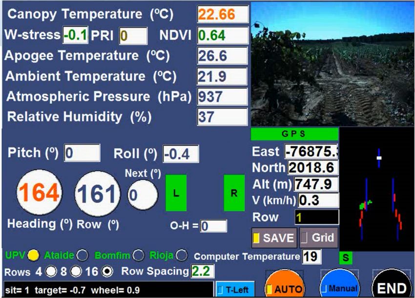
masked by noise. The NDVI measurements collected for plotting the maps of Figure 3 [94] were
collected with two sensors working simultaneously (SRS sensors, METER Group, Inc., Pullman, WA,
USA) and placed in the robot of Figure 2. One of the sensors pointed to the sky and corrected NDVI
estimates with the incident light from the sun, and the other sensor pointed sidewise to the canopy
to collect data from the leaves at an approximate distance of 0.5 m. The zenithal photo inserted on
the bottom-right corner of Figure 3a shows the VineScout autonomous robot taking data between
two rows in a vineyard. The onboard algorithm averaged individual local measurements of NDVI in
square cells of 16 m2 classified into nine NDVI levels between 0 and 1 (Figure 3a). The grid map of
Figure 3a, despite informative, is not operational, so a further simplification of data is necessary before
a grower may find it useful. Figure 3b is the result of applying a clustering filter to Figure 3a. It shows
two management zones based on vine vigor (high-medium) for the grower to make decisions, together
with water status maps, about fertilization and differential harvesting.two rows in a vineyard. The onboard algorithm averaged individual local measurements of NDVI in
square cells of 16 m2 classified into nine NDVI levels between 0 and 1 (Figure 3a). The grid map of
Figure 3a, despite informative, is not operational, so a further simplification of data is necessary
before a grower may find it useful. Figure 3b is the result of applying a clustering filter to Figure 3a.
It shows two management zones based on vine vigor (high-medium) for the grower to make
Agronomy 2020, 10, 207 9 of 21
decisions, together with water status maps, about fertilization and differential harvesting.
(a) (b)
Figure 3. Grid maps of NDVI (Normalized Difference Vegetation Index) without zoning (a), and after
applying a clustering algorithm (b).
3.3.1. Maps Containing Relevant Field Features
Displaying data in a coherent format is key for final users to understand what is happening in the
field. The most common way to display agricultural data has been in the format of maps, as mapping is
useful to define spatial trends and homogeneous zones. However, displaying agronomical information
in beautiful maps should not be the goal of map generation. Maps need to be useful for making decisions,
they need to be a help to answer a question, providing an interpretation of spatial information [39].
The goal of building maps is obtaining a few management zones with the parameters of interest so that a
treatment can be efficiently applied. To get plausible management zones, kriging is one of the most used
interpolation techniques to delimit areas of manageable sizes [43]. Taking into account the considerable
amount of data that Smart Farming generates, there are many software applications to cope with
interpolation, in general, or kriging in particular [66]. Also, when building a map, a coordinate system
needs to be supplied along with the map. One ideal alternative for agricultural maps is brought by
the Local Tangent Plane (LTP) coordinate system, which features Euclidean geometry, allows user-set
origins, and employs the intuitive coordinate frame east-north. Regarding the coding and display of
data in the maps, grids allow the systematic quantization of the LTP coordinate system to manage crop
production information more efficiently, facilitating the exchange of information among successive
seasons and the comparison of multiple parameters on the same field [67]. A practical example of
grid-based maps using LTP coordinates is shown in Figure 3.
Taking into account the key role of positioning systems, a map-based approach is the method
in which a Global Positioning System (GPS)—or any other Global Navigation Satellite System
(GNSS)—receiver and a data logger (e.g., an onboard computer) are used to record the position of a
particular measurement (georeferenced data), so several maps can be generated and processed along
with other layers of spatially variable information [68]. In general, GNSS receivers are the universal
position devices used to build maps; however, in some cases, for example in greenhouses or dense
fields of tall trees, GNSS is not the best option to use due to the difficulty of getting signals with reliable
accuracy; so, in some cases, alternative solutions such as machine vision must be implemented [69].
3.3.2. Data Management Software to Ease the Process of Decision Making
A popular way to manage field data displayed on maps and culminate with a practical solution
is through the use of Geographic Information Systems (GIS). This set of computer-based tools (or
data platforms) allows to store, analyze, manipulate and map any type of georeferenced information.
A specific GIS system called the Field-level geographic Information System (FIS) was developed
for Precision Agriculture applications [70], but it was set for old computer operative systemsAgronomy 2020, 10, 207 10 of 21 such as Windows 3.1×, 95, 98, or NT [71]. The updated version of FIS is the farm management information system (FMIS), which according to Burlacu et al. [72] is a management information system designed to assist farmers with various tasks, ranging from operational planning, implementation and documentation to the assessment of performed field work. The purpose of FMIS is to reduce production costs, comply with agricultural standards, and maintain high product quality and safety, guiding growers to make the best decisions possible [95]. Farm management software solutions support the automation of data acquisition and processing, monitoring, planning, decision making, documenting, and managing the farm operations [64], and include basic functions for record keeping like crop production rates (harvests and yields), profits and losses, farm tasks scheduling, weather prediction, soil nutrients tracking, and field mapping, up to more complex functionalities for automating field management accounting for farms and agribusinesses (accounting, inventory management, or labor contracts). In many cases, growers do not need to be fluid on data management because the software can build maps or decision-making models with basic information introduced by growers. Furthermore, a critical feature of these applications is that they even help in the early warning of weather-related hazards that enables farmers, policy makers, and aid agencies to mitigate their exposure to risk [83]. However, it must be taken into consideration that the efficiency of a recommendation for a particular agent will depend on the factors included in the algorithms of the software (technical, economic, safety-wise. . . ). In this sense, a DSSAT (Decision Support System for Agrotechnology Transfer) provides outputs with experimental data for evaluation of crop models, allowing users to compare simulated outcomes with observed results, which is critical if real-world decisions or recommendations are based on modeled results [84]. Table 2 gathers a representative set of commercially available FMIS programs specifically configured to deal with the usual data generated in the farm. It includes the name of each application program, the company commercializing it with its headquarters location, and the main features of the program. The table is focused on programs managing crop data as the primary tool, and its purpose is not the compilation of all available FMIS software, which would be futile given the rate new applications are constantly released, but bringing a proof of the global effort realized in the last decade to deploy Smart Farming in actual farms, accelerating the move from academics to agribusiness. The examples show that some smartphone and tablet applications already include complex features so that growers can insert data directly in the field; other companies, on the contrary, prefer having a basic application for mobile devices to increase complexity in the cloud-based desktop version. In the majority of cases, it is not necessary to have wireless connection while the grower is entering data in the field, because as soon as the mobile device finds a wireless connection to the internet, it synchronizes the data previously introduced by the grower in the mobile device with the data safely stored in the cloud. Many of the programs listed below offer the option of upgrading the software depending on specific grower needs, increasing the price accordingly. The most advanced tools include features for financial and machinery management, help in the decision-making process, release warnings, or even propose management advice. In many cases, these software applications are not only addressed to the grower or producer, but also to other stakeholders in agriculture such as inputs suppliers, service suppliers, and food distributors, which makes a difference for Smart Farming, where multiple agriculture agents are connected. Regarding exploitation rights, various agricultural management systems have been patented, as the software from The Climate Corp. to generate agriculture prescriptions [85], which entered into partnership with AGCO Corporation in 2017 [4]. Decisive Farming Corp. [73,74], AgVerdict Inc. [75] or Trimble [86] have also patented their commercial solutions.
Agronomy 2020, 10, 207                                                                                              11 of 21

          Table 2. Crop data management software applications and their main features [31,77–79,91].

    Software              Company        Headquarters                           Relevant Features
                                                          Input/output translator to manage data among controllers,
                                        Washington DC,    field equipment, and farm management information system
     ADAPT           AgGatekeeper
                                            USA           (FMIS) in an adequate format. Open-source system offered at
                                                          no cost for developers to adopt into their proprietary systems.
                                                          Crop data and analytics platform with mapping interface.
                                                          Able to scan and collect high-resolution crop data through
  AGERmetrix             AGERpoint       Florida, USA
                                                          LiDAR and other collaborative techniques. Permits taking
                                                          data on mobile devices.
                                                          Independent solution by a cooperative. Collect and securely
                                                          stores data. Data can be shared with trusted advisors.
     AgHub                  GiSC          Texas, USA
                                                          Integration from IBM’s Weather Operations, Main Street Data
                                                          Validator, and Market Vision.
                                                          Weather, field mapping, plan inventory. Crop, machinery, and
      Agrivi                Agrivi      United Kingdom    personnel management (notifications and reports). Web-based
                                                          and mobile versions. Upgrades and Add-ons.
                                                          Mobile App as an electronic notebook to record field activities,
                                                          products applied, workers implied, working time or
   Agroptima             Agroptima          Spain
                                                          machinery usage. Data can be downloaded on Excel, and
                                                          safely stored in the cloud. [In Spanish]
                                                          Open source. Work done, fields data, and timetables can be
                                        Netherlands and   shared with contractors or employees. Automate importing
    AgroSense              Corizon
                                             Spain        and interpreting performed tasks via ISOBUS. Export in
                                                          several formats.
                                                          Desktop and mobile app. Enables data delivery to regulatory
                      AgVerdict                           agencies or packers, shippers, and processors. Data security,
    AgVerdict                           California, USA
                     (Wilbur-Ellis)                       decision making, VRA 1 possibility, soil analysis and crop
                                                          recommendations.
                                                          Independent consulting platform for organizing field and crop
                           (Several
    Akkerweb                            The Netherlands   rotation plans. Information in one central geo-platform.
                          providers)
                                                          Several applications. [In Dutch]
                                                          Online tools enabling access to farm, machines, and
    APEX TM                                               agronomic data. Allows collaborative decisions from the same
                         John Deere      Illinois, USA
     JDLink                                               set of information to optimize logistics, plans and direct
                                                          in-field work.
                                                          Single, integrated software package. View, edit, manage,
  CASE IH AFS                                             analyze and utilize precision farming data to generate yield or
                          CASE IH       Wisconsin, USA
    software                                              VR 1 prescription maps. Maps and reports can be shared in
                                                          different formats.
                                                          Input, access, share records (images, reports) in real time.
    Connected             Trimble                         Integrates the whole system: crop scouting, grid sampling,
                                        California, USA
      Farm               Agriculture                      fleet management, contracts. Farm Core connects all aspects of
                                                          farm operation.
                                                          Productivity management system. Remote monitoring of land.
                         New Science                      Real time updates on current field and crop conditions;
     Cropio                             New York, USA
                         Technologies                     harvest forecasting. Web-based service and mobile app.
                                                          Training provided.
                                                          Customizable tool for integrated crop management.
                                                          Observation, analysis, and optimization. Vintel: Decision
 Cropwin Vintel              itk            France
                                                          support tool for vineyards. Tracks water status, cover crop
                                                          and nutrient management.
                                                          Plant-based app for irrigation. Monitors and provides data on
   The Phytech
                         PHYTECH             Israel       crop growth. All data can be used to determine overall
    Platform
                                                          water needs.
                                                          Thought to manage group of farms and farmers. Unified and
   ESE™ Agri                             Massachusetts    up-to-date farmer database. Record field visits with photos,
                         Source Trace
    solution                                 USA          notes, activities, location. Farm-to-Fork traceability of produce.
                                                          Unique ID for each farmer.
Agronomy 2020, 10, 207 12 of 21
Table 2. Cont.
Software Company Headquarters Relevant Features
Farm schedule at-a-glance or in detail. The schedule can be
Farmbrite Farmbrite Colorado, USA shared to set up daily or recurring tasks. Weather forecast
available. To-Do list, reminders, events, and appointments.
Farm management platform. Provides both hardware (i.e.,
Manitoba,
FarmCommand FarmersEdge weather station) and software for in-field decision support.
Canada
Available as a web-based tool and a mobile app.
Comparison of field performance locally and nationally.
Reports time spent by operation type, yield analysis,
Farmleap Farmleap France
production costs, irrigation follow-up, detailed weather, data
sharing, employee management (In French).
Web-based ag record-keeping. Global Positioning System
(GPS) field mapping to draw boundaries, mark points,
FarmLogic/
TapLogic Kentucky, USA measurements, etc.; personalized reports for distribution,
FarmPAD
pesticide database, maintenance records, and work
orders creation.
Mobile app for farm records, costs and expenditure
Farm
Smart farm accounting, tractor management, crop management, fertilizer
Management Ireland
software and spray compliance, staff timesheets, document
Pro
management. No desktop version available.
For crops (Gatekeeper), livestock, and business. Exchange
Farmplan data, workplans setup, weather data, data storage,
Proagrica United Kingdom
(Gatekeeper) instantaneous reports, pesticide information. Several
upgrades. Compatibility with other brands.
Data connectivity and visualization, crop performance
The Climate
FieldViewTM California, USA analysis, field health imagery. Offers VR 1 prescriptions and
Corporation
fertility management based on models.
Different software according to necessities. Combination from
several sources to build decision-making models. Advisory
Granular DowDuPont California, USA
and training services. Support for more than 230 crop
subspecies. Cloud-based.
Cloud-based agricultural management support service
integrated by Kubota machinery. For smartphones and PC.
KSAS Kubota Japan
Farm management by collecting and utilizing data from
supported machinery.
Company-oriented platform that allows automated planning,
work management, traceability, online statistics, account
Mapgrower Agropreciso Chile
management, or visualization on maps. Available for
smartphones.
Allows to define fields and their operations, plan season work
Myeasyfarm MyEasyFarm France and share it with a team, see real-time progress, and
analyze results.
Mobile devices. Packages available for VRA 1 , agronomy and
My Farm
Decisive Farming Alberta, Canada soil testing. Advice from experts. Marketing plans. Inventory
Manager
and scheduled task in Croptivity application.
It is modular so farmers can build their solution. Available in
Queensland the cloud or desktop. Training provided. Farmers can create
Phoenix Agdata
Australia maps (.shp, gpx, pdf, bmp, and jpg formats), add data, and
update them.
Enables connection with field machinery. Map and analysis of
crop/soil data, yield performance, VR 1 prescription, inventory
PLM Connect New Holland Italy
and accounting records on supplies, seeds, chemicals,
and fertilizer.
Collect and manage data in the field. Statistical analysis
SST software Proagrica United Kingdom reports, decision-making tools. PaaS 2 (agX® Platform) for the
ag industry providing geospatial infrastructure.
Soil sampling, grids and regions. Seed with higher yield
potential can be chosen based on historic performance, reports,
SMS AgLeader Iowa, USA
record operations, VRA 1 maps, and prescriptions. Mobile
app available.You can also read