Phelps Dodge Corporation

Loach Minnow and Spikedace Management Plan

       Upper Gila River, New Mexico
←
→
Page content transcription
If your browser does not render page correctly, please read the page content below
Phelps Dodge Corporation
Loach Minnow and Spikedace Management Plan
Upper Gila River, New Mexico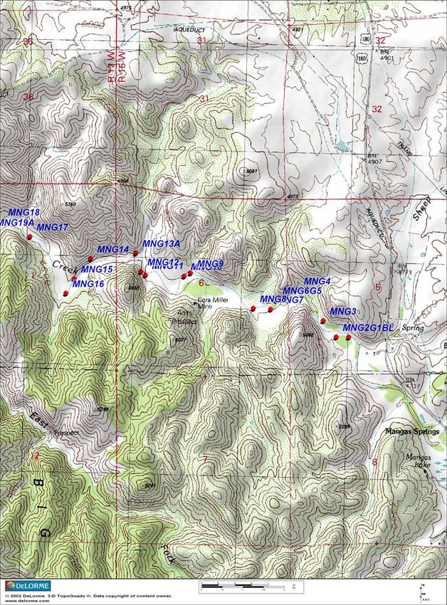
Phelps Dodge Corporation
                  Loach Minnow and Spikedace Management Plan
                         Upper Gila River, New Mexico

I.     GENERAL BACKGROUND

       The loach minnow (Tiaroga cobitis) was listed as “threatened” by the United
States Fish and Wildlife Service (“FWS”) in 1986, following proposed listing in 1985
(FWS, 1986a). The spikedace (Meda fulgida) was listed as “threatened” by FWS in
1986, following proposed listing in 1985 (FWS, 1986b). Recovery plans for the species
were finalized in 1991 (FWS, 1991a, 1991b). Critical habitat was designated for both
species in 1994 and again in 2000. Both designations were invalidated by federal courts.
FWS recently proposed critical habitat for these species on the Gila River in New
Mexico.

       A.     CHARACTERISTICS OF THE UPPER GILA RIVER

         The segment of the Upper Gila River proposed for critical habitat designation for
spikedace and loach minnow extends from Moore Canyon, near the Arizona/New Mexico
state line, 102.1 miles (164.3 km) upstream to the confluence of the East and West Forks
of the Gila River, plus 26.1 miles (42.0 km) of the East Fork, 7.7 miles (12.3 km) of the
West Fork, and 7.7 miles (12.3 km) of the Middle Fork, for a total of 143.6 miles (230.9
km). The East, West, and Middle Forks of the Gila River exit the rugged Mogollon
Mountains near Mogollon Creek northeast of Cliff and Gila, flowing across a broad
valley for approximately 15 miles before re-entering mountainous terrain near Ira
Canyon. The stream is perennial, unencumbered by major dam/reservoir systems, and
exhibits a riffle/run/pool morphology along an average gradient of 0.4% (Rinne et al.,
1999). Land ownership is principally federal (BLM, US Forest Service [Gila National
Forest], National Park Service), with private lands irregularly situated along the river,
concentrated in the Cliff/Gila area, and a lesser component of State lands in the Gila
River main stem segment.

        This management plan covers riparian lands owned by Phelps Dodge along the
reach of the Gila River as depicted in Figure 1 (“Phelps Dodge Reach”). The area
generally includes the middle reach of the main stem Gila River south of Mogollon
Creek. Land use within the Phelps Dodge Reach consists of irrigated pasture for
livestock grazing, with some recreational use. The Phelps Dodge Reach is currently
occupied by both species, and experiences periodic, significant flood events. The Phelps

                                            1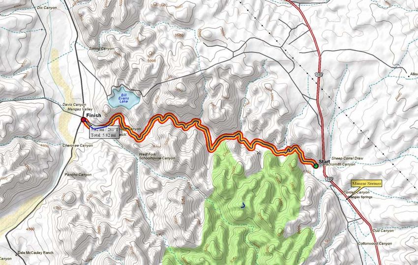
Dodge Reach also has the highest overall fish abundance of five segments of the Upper
Gila River identified by Rinne (et al., 1999). The upper portion of Rinne’s segment IV of
the Gila River roughly coincides with the Phelps Dodge Reach. Spikedace and loach
minnow combined comprised approximately 49% of the fish community in this reach
during a survey conducted in 1999. Only two non-natives, one smallmouth bass and one
yellow bullhead, were detected in this reach (Rinne et al., 1999).

         The Phelps Dodge Reach contains a high proportion of favorable habitat types for
the spikedace and loach minnow. Four major aquatic macrohabitat types have been
demonstrated to be occupied by all native species. This habitat includes high gradient
riffles (HGR), low gradient riffles (LGR), glide-runs (GRUN), and pools (POOL). LGRs
and GRUNs are the habitats in which these species are typically found. The combined
percentage of LGR and GRUNs for Rinne’s segment IV is 67%, the highest recorded for
the Upper Gila River (Rinne et al., 1999).

        Phelps Dodge’s water rights in the Gila River Basin are used for many purposes,
including mining, agricultural, and other uses. Phelps Dodge’s Gila River Basin water
rights and delivery system have been developed and maintained to provide a dependable
and adequate water supply for the operation of the Tyrone Mine. The water system
includes the Gila Diversion Structure, the Bill Evans Lake, and several wells. The Gila
Diversion Structure is located on the Gila River in the Southeast Quarter of Section 21,
Township 16 South, Range 17 West, within the Bill Evans Ranch owned by Phelps
Dodge, approximately 26 miles northwest of the Tyrone Mine. The Gila Diversion
Structure minimizes the migration of non-native fish from the lower reach of the Gila
River into the middle and upper reach of the Gila River. Notably, the area just upstream
of the Gila Diversion Structure contains very few non-native fish (Rinne et al., 1999).

        Surface water is diverted from the Gila River at the Gila Diversion Structure for
storage in Bill Evans Lake and then transported via pipeline to the Tyrone Mine facility
for subsequent use. The Bill Evans Lake is also operated as a recreational facility by the
New Mexico Game and Fish Department. Phelps Dodge primarily operates the Gila
Diversion Structure to supply water to the Tyrone Mine and maintain storage of 1,600
acre-feet in Bill Evans Lake.

       B.     PRIMARY CONSTITUENT ELEMENTS

       FWS identified several primary constituent elements (“PCE”) essential to the
conservation of the loach minnow and spikedace (FWS, 2005). The PCE identified by

                                            2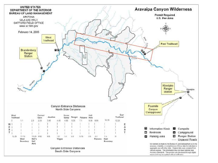
FWS in the proposed critical habitat rule include: (1) permanent, flowing water; (2) sand,
gravel, and cobble substrates; (3) pool, riffle, run, and backwater stream components; (4)
a natural, unregulated hydrograph that allows for periodic flooding or, if flows are
modified or regulated, a hydrograph that allows for adequate river functions, such as
flows capable of transporting sediments; and (5) habitat devoid of non-native fish species
detrimental to loach minnow and spikedace, or habitat in which detrimental non-native
fish are at levels which allow persistence of spikedace (FWS, 2005). Phelps Dodge
reviewed these PCE in the context of the proposed critical habitat designation and
submitted comments to FWS (Fennemore Craig, 2006). Phelps Dodge’s comments are
incorporated herein by reference.

II.    MANAGEMENT PLAN

       Although Phelps Dodge believes the Phelps Dodge Reach not require special
management and the benefits of excluding outweigh the benefits of including the Phelps
Dodge Reach, Phelps Dodge will implement the following management plan in the
Phelps Dodge Reach for the benefit of the loach minnow and spikedace. The Phelps
Dodge lands subject to this management plan are depicted in Figure 1, and the legal
descriptions are provided in Figure 2. The goals of this management plan include:

•      monitoring the distribution and abundance of the loach minnow and spikedace in
       the Gila River passing through the Phelps Dodge Reach;
•      obtaining an understanding of the population dynamics of the loach minnow and
       spikedace as they relate to existing habitat conditions and land use practices in the
       Gila River passing through the Phelps Dodge Reach;
•      continuing historic land use practices and water supply practices which enhance
       water flows in the Phelps Dodge Reach, and consideration of loach minnow and
       spikedace habitat when deviating from such historic management practices.

       Phelps Dodge believes the implementation of the management activities and
future coordination with FWS discussed below negates the need, if any, for special
management considerations or protection within the Phelps Dodge Reach. In addition,
Phelps Dodge believes this management plan results in the following benefits that might
not otherwise occur: (1) the formation of working relationships to promote the
conservation of the loach minnow and spikedace and their habitat; (2) the opportunity for
collaboration and cooperation on loach minnow and spikedace management and other
resources of interest to the Federal government; and (3) conservation benefits to riparian

                                            3
ecosystems, including habitat that may be or may potentially become suitable to loach
minnow and spikedace.
A. MANAGEMENT OF THE GILA DIVERSION STRUCTURE
Ensuring perennial flows for the loach minnow and spikedace has been identified
as a critical component to their recovery (FWS, 1991a, 1991b). As stated by FWS, the
loach minnow and spikedace “cannot exist in dewatered places, and populations can be
expected to decline or disappear from stream reaches which are intermittent or
ephemeral” (FWS, 1991a, 1991b). Moreover, “[p]ermanence of flows of sufficient
quantity and quality must be assured to maintain integrity of spikedace [and loach
minnow] populations and their habitats” (FWS, 1991a, 1991b).
Phelps Dodge’s historic operation of the Gila Diversion Structure has enhanced
water flows in the Gila River immediately upstream and downstream of the diversion
while allowing for periodic flooding and adequate river functions such as sediment
transport and sand, gravel, and cobble substrates. Under this management plan, Phelps
Dodge will continue operating its Gila Diversion Structure in this manner to the extent
legally, economically, and hydrologically reasonable under the circumstances.
It is important to note that while maintaining flows is beneficial to Phelps Dodge
and the Gila River, it is possible that Phelps Dodge operational requirements will require
short terms (weeks to months in duration) reduction or elimination of pumping and/or
diversion activities. Further, at some unknown date in the future, active mining will
cease at Tyrone and the use and diversion of water may need to be modified or moved to
an alternate location. Nothing in this management plan will impair Phelps Dodge’s
ability to hold, exercise or modify its water rights and associated uses of water as it
deems necessary under the circumstances.
Phelps Dodge also intends to maintain the Gila Diversion Structure, which is
known to prevent the immigration of non-native fish from downstream into the middle
reach of the Gila River. Such management practices are expected to promote and
maintain the integrity of native fish populations and their habitats within the Phelps
Dodge Reach of the Gila River.
B. U-BAR RANCH MANAGEMENT
For over ten years, Phelps Dodge and its wholly owned subsidiary, Pacific
Western Land Co., have supported surveys and studies of known populations of the
4Southwester Willow Flycatcher (Empidonax traillii extimus) in the Cliff/Gila Valley of
New Mexico. The focus of the studies has been on the U-Bar Ranch in Grant County,
New Mexico, which is owned by Pacific Western Land Co.
Management of the U-Bar Ranch consists of a multifaceted and highly flexible
rest-rotation system utilizing both native range and irrigated fields. The Ranch’s
numerous pastures allow for a relatively dynamic rotation system that is modified based
on current conditions. Grazing use of river bottom pastures is monitored by daily visual
inspections. Use of these pastures is limited to ensure that forage utilization levels are
moderate and over-use does not occur. In addition, all riparian areas are monitored
regularly, and riparian vegetation is allowed to propagate along the river as well as
irrigation ditches.
Management and irrigation practices of the fields described below may be modified
over time as Phelps Dodge practices sound management of its water resources:
Lower River Pasture: This pasture is located on both the east and west sides of
the Gila River from State Highway 211 downstream to State Highway 180 West. This
pasture contains native vegetation along with several old stands of improved pasture.
Although no irrigation occurs in this pasture at present, two irrigation ditches transect the
property and flow when irrigation is occurring upstream. Grazing in this pasture is
limited to the November through April period to protect riparian vegetation. The number
of animal units varies as the stocking rate is dependant upon forage conditions, but
typically is 50-75. Occasionally dry land farming occurs in this pasture during the fall,
winter and spring. The approximate acreage of this pasture is 1,000 acres.
River Pasture: This pasture is located upstream of State Highway 211 and
extends to the Hooker property. It lies along both the west and east side of the Gila
River. This pasture is narrow and contains only the Gila River and riparian vegetation
along the Gila River. Grazing is limited to November through April to protect riparian
vegetation. The animal units vary, but are typically less than 40. No farming currently
occurs in this pasture at present. The approximate acreage of this pasture is 400 acres.
Out Pasture: This pasture is located on the west side of the Gila River and is
adjacent to the River Pasture. This pasture is not irrigated at present, but significant dry
land farming does occur when moisture is available. The Upper Gila Irrigation Ditch
crosses this pasture and flows when upstream irrigation is occurring. Grazing in this
pasture is rotational, and may occur anytime during the year. Normally, however, this
5pasture is used during the summer months and in the fall and spring when dry land crops
are successful. The number of animal units in this pasture varies, but may be as high as
125 during the fall and spring. The approximate acreage is 800 acres.
Black Barn Pasture: This pasture is located west of and adjacent to the Out
Pasture. The management system and season of use is the same as the Out Pasture and
serves as part of the overall rotation of the Out Pasture. This pasture has some dry land
farming, but no current irrigation. The Upper Gila Irrigation Ditch crosses this pasture.
The approximate acreage is 250 acres, and the number of animal units is usually less than
40.
Jackson Pasture: This pasture is located on the east side of the Gila River and
adjacent to the Lower River Pasture. The season of use varies and depends on successful
dry land farming and the condition of native grasses and improved forage. The pasture
may be used any month or months of the year, but is always rested a portion of the year.
The number of animal units also varies, but normally is less than 50. The approximate
acreage of this pasture is 200 acres.
Shelby Clark Pasture: This pasture is located on the east side of the Gila River
and north of State Highway 211. This pasture has some irrigated pasture as well as
native forage. The use of this pasture is the same as the Jackson Pasture. The
approximate acreage is 40 acres, and the number of animal units may be as high as 50
during favorable forage conditions.
Garcia Pasture: The Garcia Pasture is the upper-most pasture on the east side of
the Gila River and is adjacent to the River Pasture. Very little riparian vegetation is
found in this pasture. This pasture is currently irrigated, and contains winter annuals as
well as about 40 acres of permanent pasture. The use of this pasture is the same as the
Jackson and Shelby Clark Pastures, but may be as high as 150 animal units during the fall
and spring when annual crops are available to graze. The approximate acreage of this
pasture is 400 acres.
Bennett Pasture: The Bennett Pasture is located on the west side of the Gila River
and is adjacent to the River Pasture. It is the northern-most pasture in the Gila Valley.
This pasture is currently irrigated, and primarily contains permanent pasture with some
hay. The use of this pasture is year-round because of its high forage production. The
approximate acreage of the Bennett Pasture is 300 acres, and as many as 200 animal units
may graze this area when forage is available.
6Spring Canyon Pasture: The Spring Canyon Pasture is located along the Bill
Evans Road downstream of the Highway 180 West Bridge. Although healthy riparian
forests occur in the pasture, the river valley here is very narrow and may be as little as
175 yards wide in places. Grazing occurs in this pasture from March to October. No
irrigation occurs in this pasture at present, and the approximate acreage is 8,500 acres.
The number of animal units is typically 200.
Bird Area Pasture: The Bird Area Pasture is located just north of the Gila Bird
Area on the west side of the Gila River. This pasture is primarily utilized as a corridor
for driving cattle from pasture to pasture. The approximate acreage of the Bird Area
Pasture is 300 acres. The number of animal units varies, but is typically less than 200.
As the foregoing indicates, all grazing land is carefully managed by Pacific
Western Land Co. and its grazing lessee, U-Bar Ranch, using a flexible system that
incorporates adaptive management principles. These parties determine the use and
magnitude of grazing on all Pacific Western Land Co. properties on an annual basis,
taking into account available forage, moisture and other local factors and conditions.
This rest-rotation system has been in place since 1992, and has been very successful in
the management of both forage for livestock and the development of riparian habitat for
wildlife.
C. MONITORING AND RESEARCH SUPPORTED BY PHELPS DODGE
Due to the lack of adequate information and scientific understanding, monitoring
the status of existing populations in conjunction with recovery-management actions is
important to the successful recovery of the loach minnow and spikedace (FWS, 1991a,
1991b; RMRS, 2006). In furtherance of this objective, Phelps Dodge has co-sponsored
numerous studies on the Gila River in the past ten years. More recently, the Rocky
Mountain Research Station (“RMRS”), a division of the United States Forest Service,
commenced a study in cooperation with Phelps Dodge to analyze the ecology of the loach
minnow and spikedace and their habitat in Mangas Creek and the Gila River in New
Mexico and other selected streams and rivers in Arizona (RMRS, 2006). This project is
expected to yield new information regarding native fish habitat selection and the
influence of land uses and management practices to native fish and their habitat. A copy
of the study plan is attached as Exhibit 1.
7Phelps Dodge will continue to monitor loach minnow and spikedace populations
in the Gila River Basin on a yearly basis. In conjunction with RMRS, Phelps Dodge will
continue monitoring and defining the relationships between native fish preferences for
selected habitats and various associated environmental factors (e.g., substrates, channel
conditions, vegetation, and morphology).
D. COORDINATION WITH FWS
Phelps Dodge will coordinate with FWS regarding management activities in the
Phelps Dodge Reach. Such coordination will include:
(1) Phelps Dodge will provide an annual summary to FWS regarding its
implementation of this plan. This summary will provide a brief narrative statement
affirming implementation of the plan elements over the previous year and noting any
deviations. This summary will also provide a brief narrative statement affirming
anticipated implementation of the plan for the upcoming year and noting any anticipated
deviations. The summary for each calendar year will be provided to FWS during the first
quarter of the next calendar year.
(2) Phelps Dodge will make reasonable efforts to provide FWS with notice of any
significant changes that are outside the range of historic operating parameters discussed
in this plan. When making such changes, Phelps Dodge will consider loach minnow and
spikedace habitat and any comments received from FWS, and will make reasonable
efforts to minimize adverse impacts to loach minnow and spikedace habitat to the extent
legally, economically, and practically reasonable under the circumstances. However,
nothing in this management plan will impair Phelps Dodge’s ability to hold, exercise or
modify its water rights in its sole discretion.
(3) Phelps Dodge (or its designated representative) will make reasonable efforts to
coordinate its water management activities by attending regularly scheduled fisheries
management working group meetings to stay abreast of ongoing management issues and
concerns that may affect Phelps Dodge management activities contemplated by this
management plan.
III. CONCLUSION
Phelps Dodge’s historic management of its resources in the Phelps Dodge Reach
of the Gila River has promoted loach minnow and spikedace habitat. In fact, the Phelps
8Dodge Reach currently provides habitat for one of the largest known loach minnow and
spikedace populations. The goal of this management plan is to continue management of
Phelps Dodge’s resources utilizing the proven management regime set forth above.
Phelps Dodge will continue to manage its resources consistent with these historic
operations to the extent legally, economically, and practically reasonable under the
circumstances. In addition, Phelps Dodge will make reasonable efforts to coordinate with
FWS and other stakeholders in the watershed. Phelps Dodge will also continue its
cooperative efforts with RMRS, FWS, and others to monitor and analyze the habitat of
the loach minnow and spikedace in the Gila River.
9REFERENCES
Fennemore Craig, P.C. 2006. Letter to Mr. Steve Spangle Submitting Comments on
Proposed Designation of Critical Habitat for the Spikedace and Loach Minnow.
Rinne, J. N. 1999. Fish and grazing relationships: The facts and some pleas. Fisheries
24 (8): 12-21.
Rocky Mountain Research Station. 2006. Ecology of Native Minnows and Associated
Habitat of Mangas Creek, Section of the Gila River, Southwestern New Mexico
and Selected Streams and Rivers of Arizona.
United States Fish and Wildlife Service. 1986a. Determination of Threatened Status for
the Loach Minnow. 51 Fed. Reg. 39,468.
United States Fish and Wildlife Service. 1986b. Determination of Threatened Status for
the Spikedace. 51 Fed. Reg. 23,769.
United States Fish and Wildlife Service. 1991a. Spikedace Recovery Plan.
Albuquerque, New Mexico.
United States Fish and Wildlife Service. 1991b. Loach Minnow Recovery Plan.
Albuquerque, New Mexico.
United States Fish and Wildlife Service. 2005. Proposed Designation of Critical Habitat
for the spikedace (Meda fulgida) and loach minnow (Tiaroga cobitis). 70 Fed.
Reg. 75,546.
10EXHIBIT 1
USDA Forest Service               Phone 928.556.2180
Rocky Mountain Research Station    Rocky Mountain Research Station   Fax 928.556.2130
                                   2500 South Pine Knoll Drive       Cell: 928.853.1391
                                   Flagstaff, AZ 86001

Study Plan #4302-06-02

     Ecology of Native Minnows and Associated Habitat
     of Mangas Creek, Sections of the Gila River,
     Southwestern New Mexico and Selected Streams
     and Rivers of Arizona

                               Alvin L. Medina1
                        Rangeland Management Specialist

                              Project Coordinator

                                  John N. Rinne1
                           Research Fishery Biologist

                                         And

                                  Dennis Miller2
                              Professor of Biology

                                  March 25, 2006

       1
        Rocky Mountain Research Station, RWU-4302, Watersheds and
       Riparian Ecosystems of Forests and Woodlands in the Semi-Arid West
       2
        Western New Mexico University, Silver City, NM
Study Description
1
Alvin Medina and John Rinne from the Rocky Mountain Research Station Research
Work Unit 4302, Flagstaff, Arizona, and Dennis Miller from Western New Mexico
University propose to study the ecology of native minnows and their habitats in
Mangas Creek in Southwestern New Mexico and selected streams in Arizona. The
principal focus is on understanding the population dynamics of loach minnow
(Tiaroga cobitis) and spikedace (Meda fulgida) as they relate to existing habitat
conditions and land use practices of the selected stream reaches. This study will be
initiated and completed within a period of a year. The streams of interest are Mangas
Creek located on private land belonging to Pacific Western Land Company and
Aravaipa Creek located on Bureau of Land Management land in south central
Arizona. We would propose to: (1) establish permanent sampling stations where both
fish and aquatic and terrestrial components can be measured within the same (40 m)
sample unit; (2) survey fish assemblages of the proposed study areas for the
purpose of estimating respective population sizes and age/size attributes, (2)
inventory vegetation attributes on streamsides associated with the fish sample unit to
include but not limited to vegetation cover of herbaceous plants and density of woody
plants by species, canopy cover; (3) inventory various channel attributes, including
channel substrates, channel geomorphology (profiles); (4) inventory in-channel
attributes to characterize aquatic habitat; (5) determine flow attributes of various
habitats; (6) characterize geological attributes.
This project is expected to yield ‘State of the Art’ knowledge for management of
these sensitive fish throughout their range of distribution in Arizona, New Mexico and
Mexico, including criteria for describing ‘critical habitat’ and ‘Best Management
Practices’ that conserve the species and their habitat. This project seeks answers to
key ecological questions about management of Southwestern native fish and their
habitats, which is critical for developing management criteria that can be used in
species recovery plans, public land management plans, and private land enterprises.
Various attempts to define the relationships of native fish to such land use activities
as livestock grazing have fallen short of their goal because of the difficulty in
designing cause and effect studies with sensitive species, and the cost and
complexity of accounting for many environmental factors. This study will attempt to
define relationships between native fish preferences for selected habitats and various
associated environmental factors (e.g. substrates, channel conditions, vegetation,
and morphology). In this fashion, we hope to describe the positive and negative
associations of fish and their environments. This information can subsequently be
used by resource managers to prescribe land use practices for areas where native
fish are of concern throughout the Southwest.LITERATURE REVIEW
2
A complete understanding of the ecology of minnow populations in low, desert rivers
and streams of varying size is non-existent. Several long-term studies in smaller
streams are ongoing: 1) Scientists have a 12-year record of fish assemblages
changes in the Verde River (Rinne 2005, Rinne in press); 2) A parallel study in the
upper Gila River spans 7 years (Rinne et al. 2005); and 3) There is a 25-year record
of fish assemblages in Aravaipa Creek (Fish Data Base, Arizona State University.
Whereas these existing data sets may be useful for comparing effects of floods and
droughts on native species, and perhaps for defining both micro and macro-habitat
associations and factors legislating them, not all study areas have been studied
(Mangas Creek), all have not been studied with the same objectives or in the same
manner (Aravaipa Creek), and none have been designed to address land use
impacts on habitats and, in turn, fish assemblages and abundance relative to
habitats.
Two major, controlling factors appear to interact to affect stability and integrity of
native fish populations in southwestern North America: 1) alteration of the natural
hydrograph through dams, diversions, pumping, and land use and 2) introduction of
nonnative species of fish (Rinne 2003). In all but a few streams, these factors have
eliminated native fish species and modified fish assemblage structure and dynamics,
often within a few years after the action. Streams where the native fauna remains
predominant are a rarity in the Southwest. The exact mechanism that sustains native
is not totally understood, but is thought related, in part, to the extreme droughts and
floods that characterize streams in this region, and, in part, land uses. How these
two major legislators of fish habitat and abundance interact is not entirely understood.
Clarification of these relationships is important at this time because of the ever-
increasing demand by an ever-increasing populace for riparian areas and their water
resources and the generally imperiled status of Arizona's native fish fauna. These
imperial and mostly listed fish species can have marked changes on existing and
proposed utilization of the riparian resource.
2OBJECTIVES
3
The specific objectives of this study are:
1. Survey the fish from Mangas Creek and Aravaipa Creek.
2. Survey the aquatic and terrestrial habitat of these creeks within discrete
(homogeneous) habitat conditions for aquatic, terrestrial, geomorphology, hydrology,
and geology components.
3. Examine the relationships between fish species/fish abundance and their aquatic
and terrestrial habitat attributes.
In addition, this research has the potential to provide much needed answers to
several other questions of interest to private and public land managers, although not
a specific intents of this study. These sets of questions include:
1. Why are observed populations of loach minnow and spikedace robust in the
Gila River and associated tributaries? Previous fish surveys by RMRS (Rinne
et al. 2005) of fish in the Gila River have shown unusually robust populations
of native fish which is in stark contrast to other areas (e.g. Verde River). It is
unclear what environmental factors are at play to result in these contrasts.
2. What are possible linkages between native fish and livestock grazing?
Similarly, many riparian areas in New Mexico and Arizona have been
excluded from livestock grazing based on the premise that this activity causes
adverse effects to native fish and their habitats. To date, there is no
substantiated scientific evidence to validate this premise (Rinne 2000). To the
contrary, clear evidence abounds that major threats to native fish populations
are from introduced fish into their native habitats. The clarification of these
interactions is critical knowledge for resource managers to redirect
management efforts at the conservation of native fish and their habitats.
Livestock producers have borne the impact of various conservation efforts
that may not be well founded. Hence, it remains for research to seek more
definitive answers to these questions, dispelled the myths and paradigms of
grazing effects (Rinne 1999), and develop better management practices for
grazing riparian areas.
3. What are the linkages between native minnows and their habitats? The
preponderance of scientific literature suggests that fish are directly linked to
3various terrestrial components, and as such affect population densities. These
linkages have been pursued in other streams/rivers (e.g. Verde River), but the
answers have eluded researchers because populations of these fish are
nonexistent to rare. Hence, robust fish populations are needed to identify
other environmental factors that may be operative and associated with
positive changes in fish numbers. Land management agencies are at a loss
for specifying management criteria aimed at enhancing native fish
populations. Most management efforts are aimed at protecting native fish
populations through conservative land management practices, many of which
have failed to protect native fish from extinction such as on the Verde River.
4. How do populations of spikedace and loach minnow on Mangas Creek and
Gila River (selected reaches) compare with known populations such as
Aravaipa, Eagle Creek, Blue River, and the Verde River? It is uncertain what
common factors are responsible for robust populations across the Southwest.
The populations on the Verde River are absent despite conservative
measures (e.g. livestock exclusion, limited recreation, predator removal) to
protect the fish (Rinne 2001). Fish were apparently abundant in times (pre-
1990) when recreation and livestock grazing were common impacts to the
riverine environment.
5. What are the relationships between water diversions and fish populations or
their habitats? Water diversions are a common in-channel disturbance in most
streams and rivers where the minnows are found. Considerable speculation
exists on the negative effects of these structures and their maintenance.
However, same minnows are commonly observed to occupy areas about
these sites despite their limited expanse (probably less than 99+ %) of other habitats. Are there microhabitat qualities of
these sites that attract minnows and or aid in their reproduction? It is
commonly assumed that any man-made structure or man-induced activity is
apt to have negative consequences. This question needs to be examined by
close examination of the relationships between minnows and channel
structures.
6. Assuming that land use activities have negative effects on minnows, how can
these effects be mitigated to provide secure conservation measures for fish
and ensure sustained production from the land? This is often a critically
ignored facet of research, but remains an integral component of this proposed
study. It would be short sighted to evaluate the negative effects of a given
factor, without a complete examination of all potential actions that could
mitigate those effects. Land managers require clear prescription criteria of
how to manage sensitive habitats as part of their obligation to meet multiple
resource management goals. This is a key social connection between the
land user and land manager.
7. What are the relationships between native fish preferences for selected
habitats and associated aquatic and terrestrial components (e.g. vegetation,
4channel morphology; Medina et al. 2005)? How are these same relationships
linked to existing land uses such as livestock grazing (grazed and ungrazed)?
Much of current knowledge is based on assumptions that livestock grazing
and native fish are incompatible, and is reflected in land use and recovery
plans. However, ample evidence exists that these assumptions may be
unfounded, especially where robust populations prevail (Rinne and Miller in
press). This information is critical for livestock producers and land managers,
because current land management policies advocate the exclusion of
livestock from areas of native fish habitat
8. Why are observed populations of loach minnow and spikedace robust in the
Gila River and associated tributaries? Previous fish surveys by RMRS (Rinne
et al. 2005) of fish in the Gila River have shown unusually robust populations
of native fish which is in stark contrast to other areas (e.g. Verde River; Rinne
2005). It is unclear what environmental factors are at play to result in these
contrasts.
9. What are possible linkages between native fish and livestock grazing?
Similarly, many riparian areas in New Mexico and Arizona have been
excluded from livestock grazing based on the premise that this activity causes
adverse effects to native fish and their habitats. To date, there is no
substantiated scientific evidence to validate this premise (Rinne 1999, Rinne
2000, Rinne in press). To the contrary, clear evidence abounds that major
threats to native fish populations are from introduced fish into their native
habitats. The clarification of these interactions is critical knowledge for
resource managers to redirect management efforts at the conservation of
native fish and their habitats. Livestock producers have borne the impact of
various conservation efforts that may not be well founded. Hence, it remains
for research to seek more definitive answers to these questions, dispelled the
myths and paradigms of grazing effects (Rinne 1999; Rinne and Miller in
press b), and develop better management practices for grazing riparian areas.
10. What are the linkages between native minnows and their habitats? The
preponderance of scientific literature suggests that fish are directly linked to
various terrestrial components (Rinne 1996, Rinne and Miller 2006), and as
such affect population densities. These linkages have been pursued in other
streams/rivers (e.g. Verde River), but the answers have eluded researchers
because populations of these fish are nonexistent to rare. Hence, robust fish
populations are needed to identify other environmental factors that may be
operative and associated with positive changes in fish numbers. Land
management agencies are at a loss for specifying management criteria aimed
at enhancing native fish populations. Most management efforts are aimed at
protecting native fish populations through conservative land management
practices, many of which have failed to protect native fish from extinction such
as on the Verde River.
511. How do populations of spikedace and loach minnow on Mangas Creek and
Gila River (selected reaches) compare with known populations such as
Aravaipa, Eagle Creek, Blue River, and the Verde River? It is uncertain what
common factors are responsible for robust populations across the Southwest.
The populations on the Verde River are absent despite conservative
measures (e.g. livestock exclusion, limited recreation, predator removal) to
protect the fish (Rinne 2001, 2005). Fish were apparently abundant in times
(pre-1990) when recreation and livestock grazing were common impacts to
the riverine environment.
12. What are the relationships between water diversions and fish populations or
their habitats? Water diversions are a common in-channel disturbance in most
streams and rivers where the minnows are found. Considerable speculation
exists on the negative effects of these structures and their maintenance.
However, same minnows are commonly observed to occupy areas about
these sites despite their limited expanse (probably less than 99+ %) of other habitats. Are there microhabitat qualities of
these sites that attract minnows and or aid in their reproduction? It is
commonly assumed that any man-made structure or man-induced activity is
apt to have negative consequences. This myth needs to be examined by
close examination of the relationships between minnows and channel
structures (Rinne and Miller 2006).
13. Assuming that land use activities have negative effects on minnows, how can
these effects be mitigated to provide secure conservation measures for fish
and ensure sustained production from the land? This is often a critically
ignored facet of research, but remains an integral component of this proposed
study. It would be short sighted to evaluate the negative effects of a given
factor, without a complete examination of all potential actions that could
mitigate those effects. Land managers require clear prescription criteria of
how to manage sensitive habitats as part of their obligation to meet multiple
resource management goals. This is a key social connection between the
land user and land manager.
This information could be used to conduct various analyses, including but not limited
to association analyses to ascertain what factors are associated with robust vs. non-
robust populations, principal component analyses to ascertain what factors are most
influential with respect to population attributes.
64 METHODS
A. STUDY AREAS
The principal study areas for this 2006 study are Mangas Creek in southwestern New
Mexico and Aravaipa Creek in south central Arizona. These two streams have not
been extensively studied, yet harbor abundant populations of native minnows. Other
key streams of potential interest for future studies where either loach minnow or
spikedace (or both) are found include Eagle Creek and the Blue River on the Apache
Sitgreaves NF, the Gila River, and the Verde River. The Gila and Verde rivers have
been studied extensively and much environmental data (i.e. vegetation, channel
conditions, geomorphology, water quality, macroinvertebrates, watershed condition,
historical analyses) are available for comparisons with other sites.
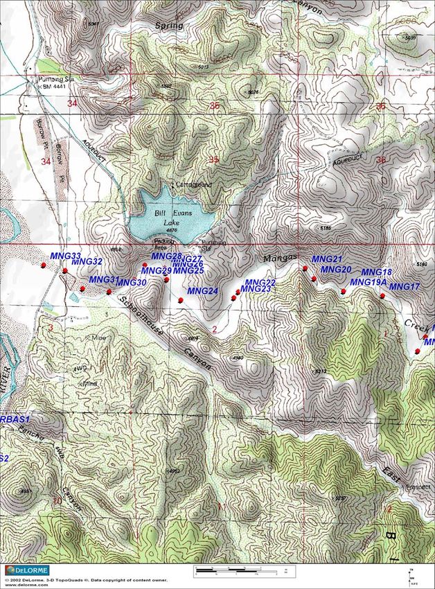
Figure 1. Location of Mangas Creek in southwestern New Mexico.
Mangas Creek is located largely on private lands belonging to Pacific
Western Land Company, a subsidiary of Phelps Dodge Corporation, Silver
City, New Mexico. Gila National Forest and Bureau of Land Management
properties adjoin the creek’s floodplain on the south sides (Figure 1). Mangas
Creek is a small six code watershed stream located in Southwestern New
7Mexico that emanates from the Mangas Springs in the Mangas Valley and
flows westerly as a tributary to the Gila River south of Cliff, New Mexico. It is
a 5.8 mile long perennial stream with a sub-watershed size of 204 square
miles, large variables in flows at different times of the year. Most of the length
of the stream is located between Highway 180 West along Blacksmith
Canyon and the confluence of the Gila River just below the location of Bill
Evans Lake and just north of Schoolhouse Canyon where it connects with the
Gila Valley. Access is limited to hiking and horseback. The area is occupied
with various historical remnants of occupation by settlers. The land use is
limited to livestock grazing. Bill Evans Lake, a popular fishing spot, lies near
the lower reaches but access to the creek is prohibited. Mangas Creek, with
its location and inaccessibility is believed by some biologists to play an
important role in maintaining the populations of spikedace and loach Minnow
in the Gila River ecosystem. Reported fish species include loach minnow
(Tiaroga cobitis), spikedace (Meda fulgida), longfin dace (Agosia
chrysogaster), and desert sucker (Catostomus clarkii) (New Mexico
Environment Department 2001). Base flow estimations range about 5-10cfs,
but the channel shows signs of probable higher (>500 cfs) flood flows.
Geologic information is available from Griffin (2001). Potential study site
locations were identified in October 2005. These sites are distributed along
Mangas Creek as depicted in Appendix A.
Aravaipa Creek is a tributary to the San Pedro River and flows through
Aravaipa Valley from the southeast to the northwest. The creek, ephemeral in
its upper reaches, becomes perennial in Aravaipa Canyon where
impermeable bedrock forces groundwater into the creek bed. Aravaipa Creek
maintains its perennial flow through the canyon before becoming ephemeral
again west of the canyon. Major tributaries to Aravaipa Creek are Stowe
Gulch, Deer Creek, Laurel Canyon, Squaw Creek, and Turkey Creek. Mean
annual flow of Aravaipa Creek, measured at the western end of Aravaipa
Canyon, is 26,059 acre-feet (EarthInfo1991). The drainage area approximates
537 square miles at the USGS gage. Base flows average about 17.6 cfs, with
a minimum of 6.5cfs and a maximum of 70,800cfs. Several springs support
perennial flow in streams tributary to Aravaipa Creek; flows of 100 to 150
gallons per minute have been reported for some springs. Summer (May-
September) flows typically range from 14.1cfs to 23.8, and are conducive for
fish sampling, with the possible exception of monsoon events. Water pH is
reported (USGS Station #09473000) as 7.8 to 8.0. Specific conductance
ranges from 240 uS/cm to 490 uS/cm. Water temperatures also fluctuate
considerably and reported between 3.2 C to 25 C. The chemical quality of
water in Aravaipa Canyon basin is suitable for most uses. Detailed analysis of
water from over 90 wells and springs in the basin was done in 1981-1982 by
Neuman and Adar (1983). Total dissolved solids concentrations ranged from
64 to 496 milligrams per liter (mg/l) and averaged 232 mg/l. The
recommended secondary maximum contaminant level for total dissolved
solids is 500 mg/l (U.S. Environmental Protection Agency, 1988). Irrigated
agriculture, grazing, and mining are the main water uses in the watershed.
8The hydrology of Aravaipa creek has been studied by Gould and Wilson
(1976) and Ellingson (1980). Geologic information is available from Robinson
(1976) and Simons (1964).
The following seven native species can be found: Agosia chrysogaster -
longfin dace, Gila robusta - roundtail chub, Meda fulgida – spikedace,
Rhinichthys osculus - speckled dace, Tiaroga cobitis - loach minnow,
Catostomus insignis - Sonora sucker, and Catostomus clarkii - desert sucker.
In addition, there are other extant and introduced species common to the
lower reaches, including: Cyprinella lutrensis - red shiner, Pimephales
promelas - fathead minnow, Ameiurus natalis - yellow bullhead, Gambusia
affinis - central mosquitofish, Lepomis cyanellus - green sunfish.
Aravaipa Creek is a stream of interest because it also harbors robust
populations of native minnows, has some long-term fishery data (ASU Fish
Data Base), and is under the jurisdiction of the Bureau of Land Management.
It would be important to compare Mangas Creek to Aravaipa Creek because
both systems are quite similar in geomorphology and hydrology, have the
same fish species, and the latter has a robust fish data base.
9B. FIELD METHODS
Field studies are planned for initiation in May 2006 and continue
throughout the summer season until all field data is collected. Unforeseen
factors e.g. illness, injuries, and weather factors such monsoons may
delay data collection for short periods, but none of these are expected to
influence the surveys.
Sampling Criteria
All fish, aquatic and terrestrial habitat surveys are nested within a 40m
stream segment. This segment size is based on the following stratification
criteria that requires a high degree of uniformity (homogeneity) in the
aquatic habitat, the terrestrial vegetation, the geomorphology of the
channel, the hydrology (e.g. channel type, flow), and the geologic/lithologic
unit. The size of 40m was determined from reconnaissance surveys where
the minimum and maximum length of stream segments that possessed all
these criteria was discerned. This size is consistent with other habitat
surveys from other study areas in desert rivers and montane streams
(Medina 1993, 1996). Units much larger than 40m trend towards higher
heterogeneity in habitat character. While heterogeneous habitats may
harbor unique populations of fish, it is not the principal focus of this study
and could be examined at a later time. Furthermore, heterogeneity is not
conducive for establishing basic fish-habitat relationships, as sampling
costs increase exponentially.
Based on field reconnaissance, six principal channel-terrestrial habitat
types were identified. Four samples of each habitat type across the entire
selected stream reach for selected Creeks will be sampled for a total of 24
per creek (e.g. Mangas, Aravaipa). All fish and habitat sampling will be
conducted in summer-fall of 2006. The aquatic habitats are limited to
uniform 40m reaches of riffles, pool-riffle complexes and glide runs. Pool
segments do not occur in 40m lengths. These aquatic habitats are seen
repeatable throughout the stream length and in association with distinct
vegetation and streambank geomorphology. Potential sample locations
are plotted and provided in Appendix A. Final selections will be made
during field sampling to insure field conditions have not changed since
reconnaissance. Sample sites selection for Aravaipa Creek will be based
on sites of similar character and criteria as used on Mangas Creek. Initial
reconnaissance of Aravaipa Creek revealed that nearly identical habitat
types were present in ample numbers.
Preliminary list of habitat types include, low gradient riffle/shrub, low
gradient riffle/tree-shrub, low gradient riffle-pool/ shrub, high gradient riffle/
shrub, high gradient riffle/ tree-shrub, and high gradient riffle-pool/ shrub.
10Sampling Stations
Each selected 40m sampling site will be identified as a permanent station
where subsequent repeated measurements can be taken within a nested
framework for habitat measurements (see Appendix B). All measurements
of vegetation, fish, channel and geomorphology are taken within the 40m
reach. Additional channel estimations are taken outside the 40m as per
Rosgen (1996). A geomorphology transect is established at or near the
20m (midpoint), perpendicular to the channel, and extends across the
floodplain to the next terrace. Small rock monuments (1’x1’x1’) are
established away from the channel, on adjacent terraces and
perpendiculars to the start (0 mark) of transect to provide a visual
landmark and distance measurements taken to transect-rebar location.
GPS location data for each location is also recorded and plotted on
topographic reference maps (see appendix A). In addition, each
vegetation transect of 40m in length is identified with rebar at each end.
These rebar locations also serve as reference markers for all other
sampling, e.g. fish, geomorphology. Geomorphology transect endpoints
are also identified with rebar (Appendix D). For all sampling work the
convention of denoting right and left streambanks facing upstream was
used.
Fish Sampling
Fish sampling is designed to expeditiously gather data with minimal impact
to fish. Sample locations are selected based on a site stratification criteria
listed above with consideration for linear disposition of available sample
sites over the entire reaches of respective streams.
Selected habitats will be sampled for fish using a 3-pass depletion method
to obtain best estimates of fish abundance and composition (Figure 2).
Study sections will be blocked on upper and lower ends with block nets
(mesh size 1/8”) to prevent fish escapement. Fish sampling will be in
sequence, progressing from a downstream to upstream direction. Fish will
be collected using backpack DC electrofishing units, seines, dipnets, and
trammel nets as appropriate to habitats conditions. Seining from upstream
to downstream is an alternative effective method of sampling spikedace.
Units of effort expressed as time and arte of electric current expended is
recorded to establish a comparative basis for fish abundance across
sample sites.
All fish captured will be held in 5 gallon buckets for rapid processing and
returned to the stream. Air bubblers can be used to reduce stress of
captive fish. Every fish will be identified to species and measured for
length. Approximately 10-20 fish, depending on availability, will be
11weighed to obtain a size-weight estimation equation for respective creeks.
In the event that many fish are captured in the first samples, or it is
estimated that many fish could be collected in the first samples, smaller
segments of the 40m reach may be sampled to expedite fish
measurements and return fish quicker to the stream. All data will be
recorded on standardized forms (Appendix E).
VEGETATION SAMPLING
Established vegetation stations are sample using a standardized
methodology (Medina 1986) for plant estimations and widely used in
monitoring changes in vegetation and channel conditions of riparian areas.
Both sides of the channel are sampled for herbaceous and woody
vegetation.
Herbaceous
Plant and ground cover estimates are determined using a technique
designed to place emphasis on vegetation about the water’s edge and on
the streambanks immediately adjacent to the channel. Detection of
aquatic and semi-aquatic plants is considered important because many
are pioneer types inhabit the water-land interface zone and they may
serve as hiding cover for fish. These plants are also extensively utilized by
herbivores, may form the microhabitat conditions necessary for other
perennial sedge-like plants to colonize, and may express the relative
condition of the streambanks in general. Herbaceous plant cover is
estimated using a modified Daubenmire approach (Medina 1986). Within
each sampling station, herbaceous vegetation is sampled within quadrats
(16.0 x 62.5 cm) located along two 40-meter transects (one on each
streambank) (Appendix B, Figure 1). These curvi-linear transects follow
the edge of the stream channel. Transects contain 40 quadrats positioned
in pairs at 2 m intervals. Quadrats are oriented with their long axis
perpendicular to the stream channel. One quadrat of each pair extends
25 cm into the stream channel to sample aquatic plants, while the other
quadrat is placed adjacent to the first and opposite the channel (rotated
about the transect axis). Aerial cover within quadrats is separated by
species and assigned to the categories developed by Bailey and Poulton
(1968). Cover of soil (< 2 mm diameter), gravel (2 mm to 7.5 cm), rock (>
7.5 cm), litter, and cryptogams was also recorded. Station averages for
total vegetative cover, cover by plant groups, and cover by ground cover
categories are calculated by averaging all 80 quadrats sampled along the
two transects (right and left bank).
12Woody
Woody vegetation is sampled in 8 x 8 m plots (10 total) along the same
40-meter sampling reaches (i.e. stations) used for herbaceous vegetation
sampling. Plots 1-5 are located on the right streambank, while plots 6-10
are located on the left streambank (Appendix B, Figure 1). All tree and
shrub species were counted and assigned to height and diameter class
(see Appendix B, Tables 1 and 2).
GEOMORPHOLOGY SAMPLING
Geomorphology data is used to characterize the local landscape
morphology of the channel and its associated floodplain. The information
collected here coupled with other channel and flow data provides a
fundamental characterization of the hydrologic regime and is useful in
contrasting habitat changes across time and space.
A cross channel transect is established across the floodplain from terrace
to terrace (Appendix D). The transect line bisects the station at mid point.
Using a laser level, the cross channel profile is determined by measuring
the vertical displacement across the horizontal transect line.
Measurements are taken starting at 0 and at 1m intervals or at intervals
that reflect the local topography. The methodology used is per Rosgen
(1996). Various additional profile measurements are taken to determine
channel type and all associated estimators of channel attributes, e.g.
bankfull.
CHANNEL SAMPLING
Channel measurements will be taken as per Rosgen (1996) to
characterize the channel type. Typical measurements include bankfull
locations, maximum depth, channel width, and sinuosity. Pebble counts
are collected as per (Bevenger and King (1998). Sample size estimates
will be determined using Bevenger and King (2001). Generally, a sample
size of 330 measurements is taken per site. Flow measurements will be
taken at each site using a digital flow meter.
Additional channel measurements will be taken of the stream-water
column (wetted zone) to characterize the volume of aquatic habitat within
the station. This is done by taking profile measurements across the stream
and recording water depths coincident with horizontal measurements.
These profiles are taken at the 0, 10, 20, 30, and 40m marks coincident
13with the vegetation transect. Under complex habitat conditions, additional
measurements may be taken.
GEOLOGIC CHARACTERIZATION
Prior to field sampling, geological data from geological maps is examined
and the lithology determined. This determination is validated in the field.
Rock samples are collected when doubt remains about the lithology.
Samples are validated by consulting with professional geologists or other
reference materials available at Northern Arizona University. This
information is recorded on the data sheets.
PHOTOGRAPHIC CHARACTERIZATION
Photographs are taken to characterize the study site. Views of the channel
and morphology profile, vegetation transects, are taken over the rebar
locations. Other views of the local landscape that aid in characterization
are also collected. These photos are subsequently referenced and
archived to match site files.
LANDUSE CHARACTERIZATION
Data about the land use that are directly associated with the study sites is
collected as part of the reconnaissance and laboratory analyses. This data
is corroborated in the field.
C. LAB METHODS
Data Analyses
All data will be transferred from field forms to Excel spreadsheets for
archival and processing. All data files will be referenced within a master
dataset for respective streams. All data is checked for errors manually and
summaries are checked against error checking programs. Only descriptive
analyses will be presented in the final report. Other statistical analyses are
limited to the production of manuscripts and beyond the scope of the
inventory and survey procedures and requirements of the study.
FISH: Fish data is summarized using descriptive statistics, archived and in
combination with graphic outputs is used to characterize site and stream
differences and similarities. Fish-weight equations will be derived from
field data and used in combination with aquatic habitat data to obtain
estimates of habitat and stream productivity.
14VEGETATION: Vegetation data is summarized using descriptive statistics
to check for errors, then archived. Summary outputs using graphs are
used in the final report.
GEOMORPHOLOGY: Geomorphology transect data is analyzed and
plotted using WINXSPRO (USDA Forest Service 1998). Output data files
are archived and referenced to study sites.
PEBBLE COUNTS: Pebble count data is analyzed using the zig-zag
pebble count analyzer of Bevenger and King (2001).
CHANNEL: Channel data is summarized to produce estimators needed to
classify the channel. Additional data from other measurements are also
incorporated to produce a characterization. Various graphic and tabular
outputs are used in the final report.
CONTRASTS: The experimental design permits various inter- and intra-
stream contrasts to be examined. In addition, association analyses can be
performed to examine relationships between fish parameters
(composition, abundance) and aquatic and terrestrial components
(substrates, vegetation cover, etc). These contrasts can be used to
compare to other study sites with different land uses and
hydrogeomorphologic conditions.
One of the emerging tools in statistics is meta-analysis, which is an
approach to combine multiple experimental results into a statistical
statement of cumulative knowledge (Hedges and Olkin 1985, Hunt 1997,
Gurevitch et al. 2001). Meta-analysis is the combined analysis and
quantitative synthesis of a collection of multiple studies generally using a
set of summary statistics for each study (Hedges and Olkin 1985). In
recent applications in ecology, meta-analysis has been extended to
include the combined analysis of complete data sets from the individual
studies, not only their summary statistics. The fish habitat data collected
here and elsewhere, e.g. Verde River, Gila River, lend themselves to
these possible forms of analyses to make collective sense of the individual
scientific findings, to sort through everything that has been done, and
come up with a summary of ‘‘what does this all mean’’ (Hobbs and Hilborn
2006).
In the absence of formal meta-analysis, scientists must either say they
know nothing other than what the data they have in hand tell them, or they
must find a way to summarize their professional opinion. Formal methods
for meta-analysis are easily learned by anyone familiar with likelihood
(Gelman et al. 1995), and have recently been extensively used in fisheries
(Hilborn and Liermann 1998, Myers 2001, Myers et al. 2001, 2002, Dorn
2002) and ecology (Bender et al. 1998, Connor et al. 2000, Schmitz et al.
2000, Chalfoun et al. 2002, Fahrig 2002, Hillebrand and Cardinale 2004).
15You can also read