Report in Support of Appropriate Assessment (AA) Screening - Youghal Lighthouse Viewing Platform, Youghal, Co. Cork. On Behalf of Cork County ...
←
→
Page content transcription
If your browser does not render page correctly, please read the page content below
Report in Support of Appropriate Assessment (AA)
                                       Screening
    Youghal Lighthouse Viewing Platform, Youghal, Co. Cork.

                                               On Behalf of
                                       Cork County Council
                                                June 2021
Project                                  Report in Support of Appropriate Assessment Screening for Youghal
                                          Lighthouse Viewing Platform, Youghal, Co. Cork

 Client                                   Cork County Council

 Project Ref.                             2153

 Report No.                               2153.01

 Client Ref.                              -

 Date                                     Revision                                                   Prepared By

 18/06/21                                 1st Draft                                                  Sorcha Sheehy BSc PhD

 21/06/21                                 Final report                                               Carl Dixon BSc MSc

                                                                                                     Cian Gill MSc

                                          DixonBrosnan Lios Ri Na hAoine, 1 Redemption Road, Cork.
                                    Tel 086 851 1437| carl@dixonbrosnan.com | www.dixonbrosnan.com

 This report and its contents are copyright of DixonBrosnan. It may not be reproduced without permission. The report is to be used only for its intended purpose. The
 report is confidential to the client, and is personal and non-assignable. No liability is admitted to third parties.
 ©DixonBrosnan 2021.

AA Screening Youghal Lighthouse Viewing Platform                                 2                                                             DixonBrosnan 2021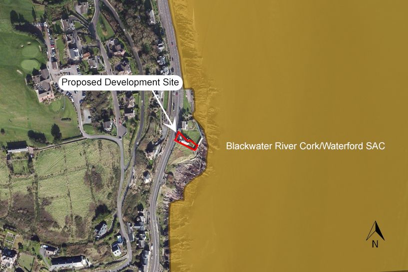
Table of Contents
1. Introduction ................................................................................................................... 5
   1.1 Background .......................................................................................................................... 5
   1.2 Aim of Report ....................................................................................................................... 5
   1.3 Authors of Report ................................................................................................................. 6
2. Regulatory Context and Appropriate Assessment Procedure .......................................... 7
   2.1 Regulatory Context ............................................................................................................... 7
   2.2 Appropriate Assessment Procedure ...................................................................................... 7
3. Receiving Environment................................................................................................... 8
   3.1 Proposed Development ........................................................................................................ 8
   3.2 Proposed Demolition Works ................................................................................................. 9
   3.3 Proposed Viewing Platform. ................................................................................................10
4. Screening ..................................................................................................................... 11
   4.1 Introduction ........................................................................................................................11
   4.2 Study Area and Scope of Appraisal ......................................................................................11
   4.3 Field Study...........................................................................................................................12
   4.4 Source-Pathway-Receptor Model ........................................................................................12
   4.5 Likely Significant Effect ........................................................................................................12
   4.6       Screening Process ..........................................................................................................12
   4.7 Desktop Review ...................................................................................................................13
5. Natura 2000 Sites......................................................................................................... 13
   5.1 Designated sites within a 15km Radius ................................................................................13
   5.2 Site summaries ....................................................................................................................19
      5.2.1 Blackwater River (Cork/Waterford) SAC ............................................................................................. 19
      5.2.2 Blackwater Estuary SPA ...................................................................................................................... 19
      5.2.3 Ballymacoda (Clonpriest and Pillmore) SAC ....................................................................................... 20
      5.2.4 Ballymacoda Bay SPA .......................................................................................................................... 20
   5.3 Natura 2000 sites – Features of interests and conservation objectives. ................................20
6. Water Quality data ...................................................................................................... 24
   6.1 River Basin Management Plan for Ireland 2018 – 2021 (2nd Cycle) ........................................24
7. Site Surveys .................................................................................................................. 26
   7.1 Habitats ...............................................................................................................................26
   7.2 Otter ...................................................................................................................................29
   7.3 Birds ....................................................................................................................................29
   7.4 Invasive Species ...................................................................................................................30

AA Screening Youghal Lighthouse Viewing Platform                             3                                                         DixonBrosnan 2021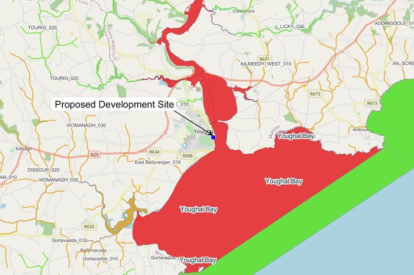
8. Potential Impacts ......................................................................................................... 30
   8.1 Potential impacts from loss of habitat .................................................................................30
   8.2 Potential impacts from noise and disturbance .....................................................................30
      8.2.1 Otter ................................................................................................................................................... 30
      8.2.2 SCI Birds .............................................................................................................................................. 31
   8.3 Potential impacts on water quality during construction .......................................................32
   8.4 Spread of Invasive Species ...................................................................................................33
   8.5 Cumulative Impacts .............................................................................................................33
9. Screening conclusion and statement ............................................................................ 36
References ....................................................................................................................... 36
Appendices ...................................................................................................................... 38

AA Screening Youghal Lighthouse Viewing Platform                                  4                                                             DixonBrosnan 2021
1. Introduction
1.1 Background

The information in this report has been compiled by DixonBrosnan Environmental
Consultants, on behalf of the applicant. It provides information on and assesses the potential
for the proposed viewing platform at Youghal Lighthouse, Youghal, Co. Cork to impact on any
Natura 2000 sites within its zone of influence. The information in this report forms part of and
should be read in conjunction with the Part VIII planning application documentation being
submitted to Cork County Council in connection with the proposed development.

The Birds Directive (2009/147/EC) and the Habitats Directive (92/42/EEC) put an obligation
on EU Member States to establish the Natura 2000 network of sites of highest biodiversity
importance for rare and threatened habitats and species across the EU. In Ireland, the Natura
2000 network of European sites comprises Special Areas of Conservation (SACs, including
candidate SACs) and Special Protection Areas (SPAs, including proposed SPAs). SACs are
selected for the conservation of Annex I habitats (including priority types which are in danger
of disappearance) and Annex II species (other than birds). SPAs are selected for the
conservation of Annex I birds and other regularly occurring migratory birds and their habitats.
The annexed habitats and species for which each site is selected correspond to the qualifying
interests of the sites and from these the conservation objectives of the site are derived. The
Birds and Habitats Directives set out various procedures and obligations in relation to nature
conservation management in Member States in general, and of the Natura 2000 sites and
their habitats and species in particular. A key protection mechanism is the requirement to
consider the possible nature conservation implications of any plan or project on the Natura
2000 site network before any decision is made to allow that plan or project to proceed. Not
only is every new plan or project captured by this requirement but each plan or project, when
being considered for approval at any stage, must take into consideration the possible effects
it may have in combination with other plans and projects when going through the process
known as Appropriate Assessment (AA).

The obligation to undertake Appropriate Assessment (AA) derives from Article 6(3) and 6(4)
of the Habitats Directive, and both involve a number of steps and tests that need to be applied
in sequential order. Article 6(3) is concerned with the strict protection of sites, while Article 6(4)
is the procedure for allowing derogation from this strict protection in certain restricted
circumstances. As set out in Section 177U of the Planning and Development Act 2000 as
amended, a screening for appropriate assessment of an application for consent for the
proposed development must be carried out by the competent authority to assess, in view of
best scientific knowledge, if the proposed development, individually or in combination with
another plan or project is likely to have a significant effect on any European site. Each step in
the assessment process precedes and provides a basis for other steps. The results at each
step must be documented and recorded carefully so there is full traceability and transparency
of the decisions made.

1.2 Aim of Report

The purpose of this report is to inform the AA process as required under the Habitats Directive
(92/43/EEC) in instances where a plan or project may give rise to significant impacts on a
Natura 2000 site. This report aims to inform the Appropriate Assessment process in

AA Screening Youghal Lighthouse Viewing Platform   5                                    DixonBrosnan 2021
determining whether the development, both alone and in combination with other plans or
projects, are likely to have a significant impact on the Natura 2000 sites in the study area, in
the context of their conservation objectives and specifically on the habitats and species for
which the sites have been designated.

This report has been prepared with regard to the following guidance documents, where
relevant.

     •    Managing Natura 2000 Sites: The Provision of Article 6 of the Habitats Directive
          92/43/EEC (European Commission (EC), 2018);

     •    Assessment of Plans and Projects Significantly Affecting Natura 2000 sites:
          Methodical Guidance on the Provisions of Article 6(3) and (4) of the Habitats Directive
          92/43/EEC (European Commission (EC), 2001);

     •    Guidance Document on Article 6(4) of the Habitats Directive 92/43/EEC (European
          Commission, (EC) 2007);

     •    Appropriate Assessment of Plans and Projects in Ireland – Guidance for Planning
          Authorities (Department of Environment, Heritage and Local Government, 2010
          revision);

     •    Appropriate Assessment under Article 6 of the Habitats Directive; Guidance for
          Planning Authorities. Circular NPW 1/10 and PSSP 2/10 (Department of Environment,
          Heritage and Local Government, 2010);

     •    Guidelines for Good Practice Appropriate Assessment of Plans under Article 6(3)
          Habitats Directive (International Workshop on Assessment of Plans under the Habitats
          Directive, 2011);

     •    Communication from the Commission on the precautionary principle. European
          Commission (2000) and

     •    CJEU Case C 164/17 Edel Grace Peter Sweetman v An Bord Pleanála.

1.3 Authors of Report

This report was prepared by Carl Dixon MSc. (Ecological Monitoring), Sorcha Sheehy PhD
(Ecology/Ornithology) and Cian Gill MSc (Ecological Monitoring).

Carl Dixon MSc (Ecology) is a senior ecologist who has over 20 years’ experience in ecological
and water quality assessments with particular expertise in freshwater ecology. He also has
experience in mammal surveys, invasive species surveys and ecological supervision of large-
scale projects. Projects in recent years include the Waste to Energy Facility Ringaskiddy,
Shannon LNG Project, supervision of the Fermoy Flood Relief Scheme, Skibbereen Flood
Relief Scheme, Upgrade of Mallow WWTP Scheme, Douglas Flood Relief Scheme, Great
Island Gas Pipeline etc. He has carried out ecological surveys and prepared AA/NIS reports
for a range of projects.

Sorcha Sheehy PhD (ecology/ornithology) is an experienced ecological consultant with over
ten years’ experience. She has worked on Screening/NIS’s for a range of small and large-

AA Screening Youghal Lighthouse Viewing Platform   6                                DixonBrosnan 2021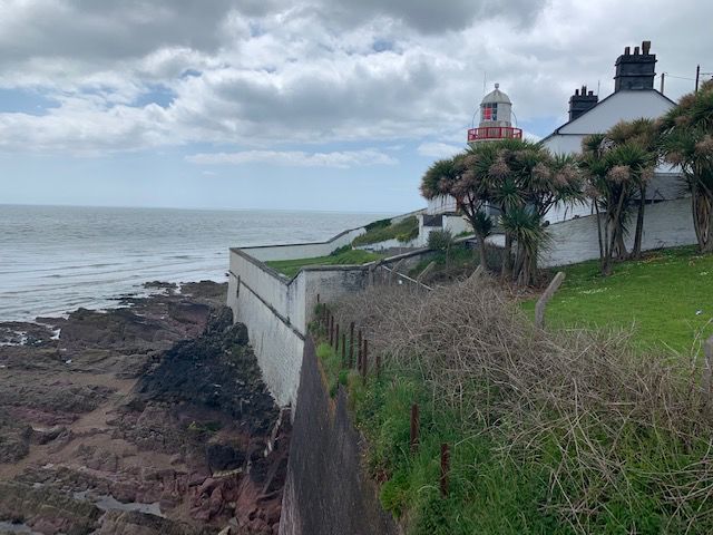
scale projects with particular expertise in assessing impacts on birds. Recent projects include
bird risk assessments for Dublin and Cork Airports, Waste to Energy Facility Ringaskiddy and
Water Storage Schemes for Irish Water.

Cian Gill MSc (Ecological Monitoring) is a qualified ecologist with ten years' experience
working with wildlife and ecology-based NGOs and public bodies in Ireland, the UK and the
US. Past projects include invasive species planning for the city of Rosemount, Minnesota, and
the Under The Sea project for Essex Wildlife Trust. Recent projects include ecological reports
for Cork-based housing and private developments.

2. Regulatory Context and Appropriate Assessment Procedure
2.1 Regulatory Context

The Habitats Directive (Council Directive 92/43/EEC on the Conservation of Natural Habitats
and of Wild Fauna and Flora) aims to maintain or restore the favourable conservation status
of habitats and species of community interest across Europe. The requirements of these
directives are transposed into Irish law through the European Communities (Birds and Natural
Habitats Regulations; S.I. No. 477 of 2011).

Under the Directive a network of sites of nature conservation importance have been identified
by each Member State as containing specified habitats or species requiring to be maintained
or returned to favourable conservation status. In Ireland the network consists of SACs and
SPAs, and also candidate sites, which form the Natura 2000 network.

Article 6(3) of Council Directive 92/43/EEC of 21 May 1992 on the Conservation of Natural
Habitats and of Wild Fauna and Flora (as amended) (hereafter ‘the Habitats Directive’)
requires that, any plan or project not directly connected with or necessary to the management
of a designated site, but likely to have a significant effect thereon, either individually or in
combination with other plans or projects, shall be subject to appropriate assessment of its
implications for the site in view of the site's conservation objectives. A competent authority
(e.g. the EPA or Local Authority) can only agree to a plan or project after having determined
that it will not adversely affect the integrity of the site concerned.

The possibility of a significant effect on a designated or “European” site has generated the
need for an appropriate assessment to be carried out by the competent authority for the
purposes of Article 6(3). A Stage Two Appropriate Assessment is required if it cannot be
excluded, on the basis of objective information, that the proposed development, individually
or in combination with other plans or projects, will have a significant effect on a European site.
The first (Screening) Stage for appropriate assessment operates merely to determine whether
a (Stage Two) Appropriate Assessment must be undertaken on the implications of the plan or
project for the conservation objectives of relevant European sites.

2.2 Appropriate Assessment Procedure

The assessment requirements of Article 6(3) establish a stage-by-stage approach. This
assessment follows the stages outlined in the 2001 European Commission publications
“Assessment of plans and projects significantly affecting Natura 2000 sites: methodological
guidance on the provisions of Articles 6(3) and 6(4) of the Habitats Directive 92/43/EEC”
(2001) and Managing Natura 2000 Sites: the provisions of Article 6 of the ‘Habitats’ Directive

AA Screening Youghal Lighthouse Viewing Platform   7                                DixonBrosnan 2021
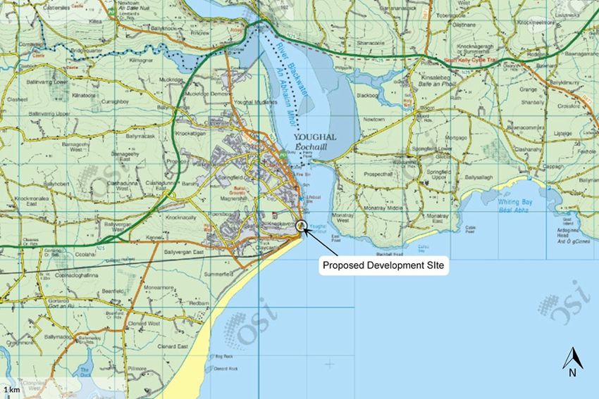
92/43/EEC (Draft) Office for Official Publications of the European Communities, Luxembourg
(EC, 2015);

The stages are as follows:

Stage One: Screening — the process which identifies any appreciable impacts upon a Natura
2000 site of a project or plan, either alone or in combination with other projects or plans, and
considers whether these impacts are likely to be significant;

Stage Two: Appropriate assessment — the consideration of the impact on the integrity of the
Natura 2000 site of the project or plan, either alone or in combination with other projects or
plans, with respect to the site’s structure and function and its conservation objectives.
Additionally, where there are adverse impacts, an assessment of the potential mitigation of
those impacts;

Stage Three: Assessment of alternative solutions: The process which examines alternative
ways of achieving the objectives of the project or plan that avoid adverse impacts on the
integrity of the Natura 2000 site. It is confirmed that no reliance is placed by the developer on
Stage Three in the context of this application for development consent;

Stage Four: Assessment where no alternative solutions exist and where adverse impacts
remain — an assessment of compensatory measures where, in the light of an assessment of
imperative reasons of overriding public interest (IROPI), it is deemed that the project or plan
should proceed (it is important to note that this guidance does not deal with the assessment
of imperative reasons of overriding public interest). Again, for the avoidance of doubt, it is
confirmed that no reliance is placed by the developer on Stage Four in the context of this
application for development consent.

It is the responsibility of the competent authority, in this instance Cork County Council, to make
a decision on whether or not the proposed development should be approved, taking into
consideration any potential impact upon any Natura 2000 site within its zone of influence.

3. Receiving Environment
3.1 Proposed Development

Youghal Lighthouse is located to the south of Youghal town centre along the western bank of
Youghal Harbour. The existing Lighthouse is accessed via the Regional Route R634. The
greater Youghal Harbour and Youghal Bay area are located to the south of the site and the
Blackwater Estuary is located to the north. Youghal Golf Links is located to the west of the
site.

AA Screening Youghal Lighthouse Viewing Platform   8                                DixonBrosnan 2021
The Lighthouse is a ‘freestanding circular-plan single-bay two-stage Lighthouse, built c. 1850,
with polygonal- plan single-bay single-stage domed lantern surrounded by cast-iron walk
balustrade. The existing Keepers Cottage is positioned to the North of the existing Lighthouse,
the Keepers Cottage and its garden is now under private ownership and as such it is not within
the curtilage of the existing Lighthouse and the proposed viewing platform.

The site is bounded to the West by Lighthouse Road (R634) and to the north by the adjoining
Lighthouse Keeper’s cottage property, a boundary wall to the South and a boundary fence to
the East, which separates the Lighthouse land from the adjoining Keeper’s Cottage.

The Lighthouse is set back from road in own grounds overlooking the coastline with coursed,
roughly dressed sandstone boundary walls to circumference, and landscaped grounds to site.

Figure 1. Site location | Source OSI.ie

3.2 Proposed Demolition Works

The proposed design seeks to remove the Generator room which was added to the southeast
of the tower and construct a new viewing platform with interpretive signage, accessible
entrance and circulation on the site of the existing 19th Century Lighthouse.

The proposed viewing platform design does not alter or use the existing Lighthouse interior or
propose to alter its internal or external fabric.

The proposed viewing platform does allow for the removal of the Generator room to the East
façade which will restore the Lighthouse to its original composition, the removal of the
Generator room will reveal the East ashlar façade of the existing Lighthouse which has
previously been hidden by the Generator.

AA Screening Youghal Lighthouse Viewing Platform   9                              DixonBrosnan 2021
As part of the proposed works the existing ashlar façade to the East will be repaired and made
good to match the existing Lighthouse façade.

The existing Generator room is located on the Eastern side of the existing Lighthouse. The
Generator room is accessed via four steps on a concrete footpath to the North. The Generator
room is a single storey blockwork structure. It has an access door on the Northern façade, a
window to the East elevation and a window and an exhaust vent to the Western elevation.
Externally the facades are rendered with a raised rendered fascia at eaves level. The roof
structure is flat with a felt roofing membrane. It has a concrete internal floor and internally there
is evidence of damp and water egress.

3.3 Proposed Viewing Platform.

The proposed viewing platform plan is 8.4m long and 5m wide to the West and tapers to 2.4m
to the East, with a glass handrail to the North, East and South façade.

The proposed design of the viewing platform is a product of the building’s orientation and
surrounding context. The orthogonal plan form offers a counterpoint to the circular plan of the
existing Lighthouse, which will allow the proposed platform to be clearly distinguished as a
new architectural intervention.

Figure 2. Contiguous section existing and proposed elevation | Source Joseph Mackey
Architects

The new viewing platform is given a sculptural quality through the use of depth and recess in
the design of the balustrade which recalls the glass prism in the existing Lighthouse. The
vertical emphasis of the balustrade acts to accentuate the verticality of the existing Lighthouse,

AA Screening Youghal Lighthouse Viewing Platform   10                                  DixonBrosnan 2021
while the ephemeral quality of the glass acts as a counterpoint to the solid mass of the existing
Lighthouse.

The floor surface of the viewing platform is finished in stone to match the existing stone paving
surrounding the existing Lighthouse. The finished floor level matches the finished floor level
of the Lighthouse footpath, which allows for level pedestrian access. The balustrade of the
proposed viewing platform is constructed in toughened glass with a ribbed effect.

It is noted that environmental control measures will be implemented during construction in line
with standard guidelines. Whilst the implementation of such measures during construction will
assist in minimising impacts on the local environment, the implementation of these measures
has not been taken into consideration in this screening report when reaching a conclusion as
to the likely impact of the development on Natura 2000 sites.

4. Screening
4.1 Introduction

This section contains the information required for the competent authority to undertake
screening for AA for the proposed development.

The aims of this section are to:

     •    Determine whether the proposed development is directly connected with, or necessary
          to, the conservation management of any Natura 2000 Sites;

     •    Provide information on, and assess the potential for the proposed development to
          significantly effect on Natura 2000 Sites (also known as European sites); and

     •    Determine whether the proposed development, alone or in combination with other
          projects, is likely to have significant effects on Natura 2000 sites in view of their
          conservation objectives.

The proposed development is not directly connected with, or necessary to the conservation
management of any Natura 2000 sites.

4.2 Study Area and Scope of Appraisal

Natura 2000 sites (European sites) are only at risk from significant effects where a source-
pathway-receptor link exists between a proposed development and a Natura 2000 site(s). This
can take the form of a direct impact (e.g. where the proposed development and/or associated
construction works are located within the boundary of the Natura 2000 site(s) or an indirect
impact where impacts outside of the Natura 2000 site(s) affect ecological receptors within (e.g.
impacts to water quality which can affect riparian habitats at a distance from the impact
source).

Considering the Natura 2000 sites present in the region, their Qualifying Interests (QIs) and
conservation objectives, and any potential impact pathways that could link those sites to the
proposed development area, a distance of 15km was considered appropriate to encompass
all Natura 2000 sites potentially within the Zone of Influence (ZoI) of the proposed
development.

AA Screening Youghal Lighthouse Viewing Platform   11                              DixonBrosnan 2021
Thus, any appreciable direct, indirect or cumulative impacts which could arise from the
proposed development in relation to the designated sites within this zone were considered.
4.3 Field Study
A site inspection was carried out on the 14th of June 2021 to identify the habitats, flora and
fauna present at the site. The surveys assessed the potential for all Qualifying Interests (QIs)/
Special Conservation Interests (SCIs) of European sites and third schedule invasive species
to occur within the proposed site.
4.4 Source-Pathway-Receptor Model
The likely effects of the proposed development on any European site has been assessed
using a source-pathway-receptor model, where:
• A ‘source’ is defined as the individual element of the proposed works that has the
potential to impact on a European site, its qualifying features and its conservation
objectives.
• A ‘pathway’ is defined as the means or route by which a source can affect the
ecological receptor.
• A ‘receptor’ is defined as the SCI of SPAs or QI of SACs for which conservation
objectives have been set for the European sites being screened.
A source-pathway-receptor model is a standard tool used in environmental assessment. In
order for an effect to be likely, all three elements of this mechanism must be in place. The
absence or removal of one of the elements of the mechanism results in no likelihood for the
effect to occur. The source-pathway-receptor model was used to identify a list of European
sites, and their QIs/SCIs, with potential links to European sites. These are termed as ‘relevant’
European sites/QIs/SCIs throughout this report.
4.5 Likely Significant Effect
The threshold for a Likely Significant Effect (LSE) is treated in the screening exercise as being
above a de minimis level. The opinion of the Advocate General in CJEU case C-258/11
outlines:
“the requirement that the effect in question be ‘significant’ exists in order to lay down a de
minimis threshold. Plans or projects that have no appreciable effect on a European site are
thereby excluded.
If all plans or projects capable of having any effect whatsoever on the site were to be caught
by Article 6(3), activities on or near the site would risk being impossible by reason of legislative
overkill.”
In this report, therefore, ‘relevant’ European sites are those within the potential ZoI of activities
associated with the construction and operation of the proposed development, where LSE
pathways to European sites were identified through the source-pathway-receptor model.
4.6 Screening Process
The Screening for Appropriate Assessment will incorporate the following steps:
AA Screening Youghal Lighthouse Viewing Platform 12 DixonBrosnan 2021Definition of the zone of influence for the proposed works;
• Identification of the European sites that are situated (in their entirety or partially or
downstream) within the zone of influence of the proposed works;
• Identification of the most up-to-date QIs and SCIs for each European site within the
zone of influence;
• Identification of the environmental conditions that maintain the QIs/SCIs at the desired
target of Favourable Conservation Status;
• Identification of the threats/impacts – actual or potential that could negatively impact
the environmental conditions of the QIs/SCIs within the European sites;
• Highlighting the activities of the proposed works that could give rise to significant
negative impacts; and
• Identification of other plans or projects, for which in-combination impacts would likely
have significant effects.
4.7 Desktop Review
A desktop review facilitates the identification of the baseline ecological conditions and key
ecological issues relating to Natura 2000 sites and facilitates an evaluation assessment of
potential in-combination impacts. Sources of information used for this report include reports
prepared for the Youghal area and information from statutory and non-statutory bodies. The
following sources of information and relevant documentation were utilised:
• National Parks & Wildlife Service (NPWS) - www.npws.ie
• Environmental Protection Agency (EPA) – www.epa.ie
• National Biodiversity Data Centre – www.biodiversityireland.ie
• Cork County Biodiversity Action Plan 2009-2014;
• Cork County Development Plan 2014 (Cork City Council, 2015);
• Birdwatch Ireland - http://www.birdwatchireland.ie/
• British Trust for Ornithology (BTO)-www.BTO.org
• Invasive Species Ireland - http://www.invasivespeciesireland.com/
• Best Practice Guidance for Habitat Survey and Mapping (Heritage Council, 2011)
• Guidelines for Assessment of Ecological Impacts of National Road Schemes
(National Roads Authority, 2009).
• Environmental Impact Assessment of Projects Guidance on the preparation of the
Environmental Impact Assessment Report (Directive 2011/92/EU as amended by
2014/52/EU) European Union, 2017 and
• Cork City D0033-01 Wastewater Treatment Plant (WWTP) Annual Environmental
Report 2019 (Irish Water 2020)
5. Natura 2000 Sites
5.1 Designated sites within a 15km Radius
In accordance with the European Commission Methodological Guidance (EC 2018), a list of
Natura 2000 sites that can be potentially affected by the proposed development has been
compiled. All candidate SAC’s (cSAC) and SPAs sites within a 15km radius of the proposed
development have been identified in Table 1 and shown in Figure 3. It is noted that use of a
AA Screening Youghal Lighthouse Viewing Platform 13 DixonBrosnan 202115km radius is a precautionary measure, as impacts at this distance from the proposed
development are highly unlikely in the absence of significant aqueous or air emissions.
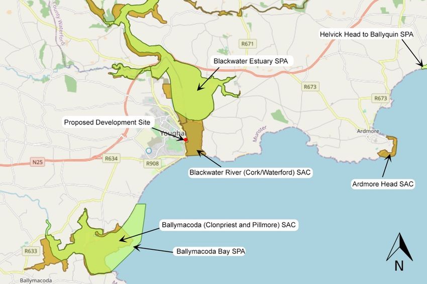
The proposed development site is located approximately 20m west of the Blackwater River
(Cork/Waterford) SAC. Given its proximity to the site, surface water runoff from the proposed
development site could potentially impact on water quality within the Blackwater River
(Cork/Waterford) SAC. Ballymacoda Bay SAC is also potentially hydrologically connected to
the proposed development via Youghal Harbour/Youghal Bay.
SCI species for the Blackwater Estuary SPA or Ballymacoda Bay SPA could potentially forage
in the vicinity of the site. Otter, a qualifying species for the Blackwater River (Cork/Waterford)
SAC could also be disturbed or displaced during construction works. Therefore, noise and
disturbance during the construction phase could potentially impact on SCI species within these
sites. It is noted that the habitats within the proposed development site do not provide ex-situ
foraging grounds for SCI species.
Therefore, a source-pathway-receptor link has been identified between the source (proposed
development) and the receptors (Blackwater River (Cork/Waterford) SAC, Ballymacoda Bay
SAC, Blackwater Estuary SPA and Ballymacoda Bay SPA) via a potential pathway (surface
water runoff, the spread of invasive species and disturbance during construction/operational
phase). Further information on these Natura 2000 sites is provided below and a full site
synopsis included Appendix 1.
Given the distances involved, the lack of hydrological connection and the lack of natural or
semi-nature habitats onsite, no pathway for impact has been identified between the proposed
development site and any other Natura 2000 site.
Table 1. Natura 2000 sites and their location relative to the proposed development site
Natura 2000 Sites Site Distance at Qualifying Interests
Code closest point and (* denotes a priority habitat)
potential source-
pathway-receptor
link
Special Area of Conservation (SAC)
Blackwater River 002170 20m east. A source- Habitats
(Cork/Waterford) SAC pathway-receptor
link has been Estuaries [1130]
identified between
the source Mudflats and sandflats not covered by seawater at
(proposed low tide [1140]
development site)
Perennial vegetation of stony banks [1220]
and the receptor
(Blackwater River Salicornia and other annuals colonising mud and
(Cork/Waterford) sand [1310]
SAC) via a potential
pathway (impacts on Atlantic salt meadows (Glauco-Puccinellietalia
water quality, maritimae) [1330]
disturbance or
spread of invasive Mediterranean salt meadows (Juncetalia maritimi)
species during [1410]
AA Screening Youghal Lighthouse Viewing Platform 14 DixonBrosnan 2021Natura 2000 Sites Site Distance at Qualifying Interests
Code closest point and (* denotes a priority habitat)
potential source-
pathway-receptor
link
construction or Water courses of plain to montane levels with the
operational phase). Ranunculion fluitantis and Callitricho-Batrachion
vegetation [3260]
Old sessile oak woods with Ilex and Blechnum in
the British Isles [91A0]
Alluvial forests with Alnus glutinosa and Fraxinus
excelsior (Alno-Padion, Alnion incanae, Salicion
albae) [91E0]
Species
Margaritifera margaritifera (Freshwater Pearl
Mussel) [1029]
Austropotamobius pallipes (White-clawed Crayfish)
[1092]
Petromyzon marinus (Sea Lamprey) [1095]
Lampetra planeri (Brook Lamprey) [1096]
Lampetra fluviatilis (River Lamprey) [1099]
Alosa fallax fallax (Twaite Shad) [1103]
Salmo salar (Salmon) [1106]
Lutra lutra (Otter) [1355]
Trichomanes speciosum (Killarney Fern) [1421]
Ballymacoda 000077 4.4km south A Habitats
(Clonpriest and source-pathway-
Pillmore) SAC receptor link has Estuaries [1130]
been identified
between the source Mudflats and sandflats not covered by seawater at
(development site) low tide [1140]
and the receptor
Salicornia and other annuals colonising mud and
(Ballymacoda
sand [1310]
(Clonpriest and
Pillmore) SAC) via a Atlantic salt meadows (Glauco-Puccinellietalia
potential pathway maritimae) [1330]
(impacts on water
quality, disturbance Mediterranean salt meadows (Juncetalia maritimi)
or spread of invasive [1410]
species during
construction or
operational phase).
AA Screening Youghal Lighthouse Viewing Platform 15 DixonBrosnan 2021Natura 2000 Sites Site Distance at Qualifying Interests
Code closest point and (* denotes a priority habitat)
potential source-
pathway-receptor
link
Ardmore Head SAC 002123 8.4km east. No Habitats
significant pathway
exists. Vegetated sea cliffs of the Atlantic and Baltic coasts
[1230]
European dry heaths [4030]
Special Protection Area (SPA)
Blackwater Estuary 004028 1.4km north. A Birds
SPA source-pathway-
receptor link has Anas Penelope (Wigeon) [A050]
been identified
between the source Pluvialis apricaria (Golden Plover) [A140]
(proposed
development site) Vanellus vanellus (Lapwing) [A142]
and the receptor
Calidris alpine (Dunlin) [A149]
(Blackwater Estuary
SPA) via a potential
Limosa limosa (Black-Tailed Godwit) [A156]
pathway (impacts on
water quality,
Limosa lapponica (Bar-Tailed Godwit) [A157]
disturbance during
construction or
operational phase). Numenius arquata (Curlew) [A160]
Tringa tetanus (Redshank) [A162]
Wetland and Waterbirds [A999]
Ballymacoda Bay 004023 2.9km southwest. A Birds
SPA source-pathway- Anas Penelope (Wigeon) [A050]
receptor link has
been identified Anas crecca (Teal) [A052]
between the source
(proposed Charadrius hiaticula (Ringed plover) [A137]
development site)
and the receptor Pluvialis apricaria (Golden Plover) [A140]
(Blackwater Estuary
SPA) via a potential Pluvialis squatarola (Grey Plover) [A141]
pathway (impacts on
water quality, Vanellus vanellus (Lapwing) [A142]
disturbance during
construction or Calidris alba (Sanderling) [A144]
operational phase).
Calidris alpine (Dunlin) [A149]
Limosa limosa (Black-Tailed Godwit) [A156]
Limosa lapponica (Bar-Tailed Godwit) [A157]
Numenius arquata (Curlew) [A160]
AA Screening Youghal Lighthouse Viewing Platform 16 DixonBrosnan 2021Natura 2000 Sites Site Distance at Qualifying Interests
Code closest point and (* denotes a priority habitat)
potential source-
pathway-receptor
link
Tringa tetanus (Redshank) [A162]
Arenaria interpres (Turnstone) [A169]
Chroicocephalus ridibundus (Black-Headed Gull)
[A179]
Larus canus (Common Gull) [A182]
Larus fuscus (Lesser Black-Backed Gull) [A183]
Wetland and Waterbirds [A999]
Helvick Head to 004192 10.9km No pathway Birds
Ballyquin SPA exists
A346 Chough (Pyrrhocorax pyrrhocorax)
A017 Cormorant (Phalacrocorax carbo)
A188 Kittiwake (Rissa tridactyla)
A103 Peregrine (Falco peregrinus)
A184 Herring Gull (Larus argentatus)
Ballycotton Bay SPA 004022 14.1km west. No Birds
pathway exists.
Anas crecca (Teal) [A052]
Charadrius hiaticula (Ringed plover) [A137]
Pluvialis apricaria (Golden Plover) [A140]
Pluvialis squatarola (Grey Plover) [A141]
Vanellus vanellus (Lapwing) [A142]
Limosa limosa (Black-Tailed Godwit) [A156]
Limosa lapponica (Bar-Tailed Godwit) [A157]
Numenius arquata (Curlew) [A160]
Arenaria interpres (Turnstone) [A169]
Larus canus (Common Gull) [A182]
Larus fuscus (Lesser Black-Backed Gull) [A183]
Wetland and Waterbirds [A999]
AA Screening Youghal Lighthouse Viewing Platform 17 DixonBrosnan 2021Figure 3. Natura 2000 sites within 15km radius of the proposed development site | Source EPA Envision Mapping | Not to scale Figure 4. Proposed development relative the Blackwater River (Cork/Waterford) SAC| Approximate red line boundary | Source EPA Envision Mapping | Not to scale AA Screening Youghal Lighthouse Viewing Platform 18 DixonBrosnan 2021
5.2 Site summaries

5.2.1 Blackwater River (Cork/Waterford) SAC

This very large site drains a major part of County Cork and five mountain ranges. The site
supports a high diversity of Annex I habitats and Annex II species of the E.U. Habitats
Directive, including Atlantic salmon and Otter. The site designated as the Blackwater River
cSAC consists of the freshwater stretches of the River Blackwater as far upstream as
Ballydesmond and as far downstream as the tidal stretches into Youghal Harbour as well as
the many tributaries along the way, the larger of which include the Licky, Bride, Flesk,
Chimneyfield, Finisk, Araglin, Awbeg (Buttevant), Clyda, Glen, Allow, Dalua, Brogeen,
Rathcool, Finnow, Owentaraglin and Awnaskirtaun. The extent of the Blackwater and its
tributaries in this site flows through the counties of Kerry, Cork, Limerick, Tipperary and
Waterford. The designated site covers a total area of 15,048 ha.

The main threats to the site and current damaging activities include high inputs of nutrients
into the river system from agricultural run-off and several sewage plants, dredging of the upper
reaches of the Awbeg, over-grazing within the woodland areas, and invasion by non-native
species, for example Rhododendron and Cherry Laurel.

Overall, the River Blackwater is of considerable conservation significance for the occurrence
of good examples of habitats and populations of plant and animal species that are listed on
Annexes I and II of the E.U. Habitats Directive respectively. Furthermore, it is of high
conservation value for the populations of bird species that use it. Two Special Protection
Areas, designated under the E.U. Birds Directive, are also located within the site - Blackwater
Callows and Blackwater Estuary. Additionally, the importance of the site is enhanced by the
presence of a suite of uncommon plant species.

A full site synopsis for the River Blackwater (Cork/Waterford) SAC is included as Appendix 1
of this report.

5.2.2 Blackwater Estuary SPA

The Blackwater Estuary SPA is a moderately-sized, sheltered south-facing estuary, which
extends from Youghal New Bridge to the Ferry Point peninsula, close to where the river enters
the sea. It comprises a section of the main channel of the River Blackwater to Ballynaclash
Quay. At low tide, intertidal flats are exposed on both sides of the channel. On the eastern
side the intertidal channel as far as Kinsalebeg and Moord Cross Roads is included, while on
the west side the site includes part of the estuary of the Tourig River as far as Kilmagner.

The site is a Special Protection Area (SPA) under the E.U. Birds Directive, of special
conservation interest for the following species: Wigeon, Golden Plover, Lapwing, Dunlin,
Black-tailed Godwit, Bar-tailed Godwit, Curlew and Redshank. The E.U. Birds Directive pays
particular attention to wetlands and, as these form part of this SPA, the site and its associated
waterbirds are of special conservation interest for Wetland & Waterbirds.

The Blackwater Estuary SPA is an internationally important wetland site on account of the
population of Black-tailed Godwit it supports. It is also of high importance in a national context,
with seven species having populations which exceed the thresholds for national importance.
The occurrence of Little Egret, Golden Plover and Bar-tailed Godwit is of particular note as

AA Screening Youghal Lighthouse Viewing Platform   19                                DixonBrosnan 2021
these species are listed on Annex I of the E.U. Birds Directive. The Blackwater Estuary is also
a Ramsar Convention site.

5.2.3 Ballymacoda (Clonpriest and Pillmore) SAC

This coastal site stretches north-east from Ballymacoda to within about 6 km of Youghal, Co.
Cork. Though moderate in size, it has a good diversity of coastal habitats, including several
listed on Annex I of the E.U. Habitats Directive. The site is a Special Area of Conservation
(SAC) selected for the following habitats and/or species listed on Annex I / II of the E.U.
Habitats Directive (* = priority; numbers in brackets are Natura 2000 codes): [1130] Estuaries,
[1140] Tidal Mudflats and Sandflats, [1310] Salicornia Mud, [1330] Atlantic Salt Meadows, and
[1410] Mediterranean salt meadows (Juncetalia maritimi).

Ballymacoda is a fine example of an estuarine complex, with intertidal flats well represented.
The site is of high conservation importance because several of the habitats present are listed
on Annex I of the E.U. Habitats Directive. However, there is also considerable ornithological
interest; Ballymacoda is one of the most important bird sites in the country and supports a
higher number of waders than any other Co. Cork estuary of its size. It also contains important
numbers of Golden Plover and Bar-tailed Godwit, two E.U. Birds Directive Annex I species,
an internationally important population of Black-tailed Godwit, and nationally important
numbers of a further 13 bird species. A full site synopsis for the Ballymacoda SAC is included
as Appendix 1 of this report.

5.2.4 Ballymacoda Bay SPA

This coastal site stretches north-east from Ballymacoda to within several kilometres of
Youghal, Co. Cork. It comprises the estuary of the Womanagh River, a substantial river which
drains a large agricultural catchment. Part of the tidal section of the river is included in the site
and on the seaward side the boundary extends to, and includes, Bog Rock, Barrel Rocks and
Black Rock. The inner part of the estuary is well sheltered by the Ring peninsula, a stabilised
sand spit with sand dunes at its northern end and salt marshes on the landward side. Sediment
types vary from muds to muddy sands in the inner part to fine rippled sands in the outer
exposed part. The site is a Special Protection Area (SPA) under the E.U. Birds Directive, of
special conservation interest for the following species: Wigeon, Teal, Ringed Plover, Golden
Plover, Grey Plover, Lapwing, Sanderling, Dunlin, Black-tailed Godwit, Bar-tailed Godwit,
Curlew, Redshank, Turnstone, Black-headed Gull, Common Gull and Lesser Black-backed
Gull. The site is also of special conservation interest for holding an assemblage of over 20,000
wintering waterbirds. The E.U. Birds Directive pays particular attention to wetlands and, as
these form part of this SPA, the site and its associated waterbirds are of special conservation
interest for Wetland & Waterbirds. A full site synopsis for the Ballymacoda Bay SPA is included
as Appendix 1 of this report.

5.3 Natura 2000 sites – Features of interests and conservation objectives.

The EU Habitats Directive contains a list of habitats (Annex I) and species (Annex II) for which
SACs must be established by Member States. Similarly, the EU Birds Directive contains lists
of important bird species (Annex I) and other migratory bird species for which SPAs must be
established. Those that are known to occur at a site are referred to as ‘qualifying interests’
and are listed in the Natura 2000 forms which are lodged with the EU Commission by each
Member State. A ‘qualifying interest’ is one of the factors (such as the species or habitat that

AA Screening Youghal Lighthouse Viewing Platform   20                                  DixonBrosnan 2021
is present) for which the site merits designation. The National Parks and Wildlife Service
(NPWS) are responsible for the designation of SACs and SPAs in Ireland.

The overall aim of the Habitats Directive is to maintain or restore the favourable conservation
status of habitats and species of community interest. These habitats and species are listed in
the Habitats and Birds Directives and Special Areas of Conservation and Special Protection
Areas are designated to afford protection to the most vulnerable of them. These two
designations are collectively known as the Natura 2000 network. European and national
legislation places a collective obligation on Ireland and its citizens to maintain at favourable
conservation status sites designated as Special Areas of Conservation and Special Protection
Areas. The Government and its agencies are responsible for the implementation and
enforcement of regulations that will ensure the ecological integrity of these sites.

The maintenance of habitats and species within Natura 2000 sites at favourable conservation
condition will contribute to the overall maintenance of favourable conservation status of those
habitats and species at a national level. Favourable conservation status of a habitat is
achieved when its natural range, and area it covers within that range, is stable or increasing,
and the ecological factors that are necessary for its long-term maintenance exist and are likely
to continue to exist for the foreseeable future, and the conservation status of its typical species
is favourable.

The conservation objectives for the Blackwater River (Cork/Waterford) SAC, Ballymacoda Bay
SAC, Blackwater Estuary SPA and Ballymacoda Bay SPA are detailed in the following
publications:

NPWS (2012) Conservation Objectives: Blackwater River (Cork/Waterford) SAC 002170,
Version 1. NPWS, Department of Arts, Heritage & the Gaeltacht.

NPWS 2015. Conservation Objectives: Ballymacoda (Clonpriest and Pillmore) SAC 000077
NPWS, Department of Arts, Heritage & the Gaeltacht.

NPWS (2015) Conservation Objectives: Ballymacoda Bay SPA 004023 Version 1. NPWS,
Department of Arts, Heritage & the Gaeltacht.

NPWS (2012) Conservation Objectives: Blackwater Estuary SPA 004028. Version 1.0.
National Parks and Wildlife Service, Department of Arts, Heritage and the Gaeltacht.

The favourable conservation status of a species is achieved when population data on the
species concerned indicate that it is maintaining itself, and the natural range of the species is
neither being reduced or likely to be reduced for the foreseeable future, and there is, and will
probably continue to be, a sufficiently large habitat to maintain its populations on a long-term
basis. The species and/or habitats listed as qualifying interests for the Blackwater River
(Cork/Waterford) SAC, Ballymacoda Bay SAC, Blackwater Estuary SPA and Ballymacoda
Bay SPA and specific conservation objectives are included in Tables 2 - 6.

AA Screening Youghal Lighthouse Viewing Platform   21                                DixonBrosnan 2021
Table 2. Qualifying Species for the Blackwater River (Cork/Waterford) SAC

 Species          Species                                                                 Conservation objective
 code
 1029             Freshwater Pearl Mussel               Margaritifera margaritifera       Restore
 1092             White-clawed crayfish                 Austropotamobius pallipes         Maintain
 1095             Sea Lamprey                           Petromyzon marinus                Restore
 1096             Brook Lamprey                         Lampetra planeri                  Maintain
 1099             River Lamprey                         Lampetra fluviatilis              Maintain
 1103             Twaite shad                           Alosa fallax                      Restore
 1106             Atlantic Salmon                       Salmo salar                       Maintain
 1355             Otter                                 Lutra lutra                       Restore
 1421             Killarney Fern                        Trichomanes speciosum             Maintain
Restore = Restore favourable conservation condition, Maintain = Maintain favourable conservation condition

Table 3. Qualifying Habitats for the Blackwater River (Cork/Waterford) SAC

 Habitat      Habitat                                                                             Conservation
 Code                                                                                             objective
 1130         Estuaries                                                                           Maintain
 1220         Perennial vegetation of stony banks                                                 Maintain
 1140         Mudflats and sandflats not covered by seawater at low tide                          Maintain
 1310         Salicornia and other annuals colonizing mud and sand                                Maintain
 1330         Atlantic salt meadows (Glauco-Puccinellietalia maritimae)                           Restore
 1410         Mediterranean salt meadows (Juncetalia maritimi)                                    Maintain
 3260         Water courses of plain to montane levels with the Ranunculion fluitantis and        Maintain
              Callitricho-Batrachion vegetation
 91E0         Alluvial forests with Alnus glutinosa and Fraxinus excelsior (Alno-Padion, Alnion   Restore
              incanae, Salicion albae)
 91J0         *Taxus baccata woods of the British Isles                                           Under Review
 91A0         Old sessile oak woods with Ilex and Blechnum in British Isles                       Restore
Restore = Restore favourable conservation condition, Maintain = Maintain favourable conservation condition

Table 4. Special Conservation Interests (SCIs) for Blackwater Estuary SPA

 Species       Species                             Scientific name                           Conservation
 code                                                                                        objective

 A050          Wigeon                              Anas Penelope                             Maintain

 A140          Golden Plover                       Pluvialis apricaria                       Maintain

 A142          Lapwing                             Vanellus vanellus                         Maintain

 A149          Dunlin                              Calidris alpina                           Maintain

 A156          Black-tailed Godwit                 Limosa limosa                             Maintain

 A157          Bar-tailed Godwit                   Limosa lapponica                          Maintain

AA Screening Youghal Lighthouse Viewing Platform           22                                        DixonBrosnan 2021
Species Species Scientific name Conservation code objective A160 Curlew Numenius arquata Maintain A162 Redshank Tringa totanus Maintain A999 Wetland and Waterbirds Maintain Table 5. Qualifying Interests (QI) for Ballymacoda (Clonpriest and Pillmore) SAC Habitat Qualifying Interests Conservation code objective 1130 Estuaries Maintain 1140 Mudflats and sandflats not covered by seawater at low tide Maintain 1310 Salicornia and other annuals colonising mud and sand Restore 1330 Atlantic salt meadows (Glauco-Puccinellietalia maritimae) Maintain Restore = Restore favourable conservation condition, Maintain = Restore favourable conservation condition Table 6. Special Conservation Interests (SCIs) for the Ballymacoda Bay SPA Species Species Scientific name Conservation code objective A050 Wigeon Anas Penelope Maintain A052 Teal Anas crecca Maintain A137 Ringed Plover Charadrius hiaticula Maintain A140 Golden Plover Pluvialis apricaria Maintain A141 Grey Plover Pluvialis squatarola Maintain A142 Lapwing Vanellus vanellus Maintain A144 Sanderling Calidris alba Maintain A149 Dunlin Calidris alpina Maintain A156 Black-tailed Godwit Limosa limosa Maintain A157 Bar-tailed Godwit Limosa lapponica Maintain A160 Curlew Numenius arquata Maintain A162 Redshank Tringa totanus Maintain A169 Turnstone Arenaria interpres Maintain A179 Black-headed Gull Chroicocephalus ridibundus Maintain AA Screening Youghal Lighthouse Viewing Platform 23 DixonBrosnan 2021
Species       Species                             Scientific name                      Conservation
 code                                                                                   objective

 A182          Common Gull                         Larus canus                          Maintain

 A183          Lesser Black-Backed Gull            Larus fuscus                         Maintain

 A999          Wetland and Waterbirds                                                   Maintain

Restore = Restore favourable conservation condition, Maintain = Restore favourable conservation condition

To acknowledge the importance of Ireland's wetlands to wintering waterbirds, “Wetland and
Waterbirds” may be included as a Special Conservation Interest for some SPAs that have
been designated for wintering waterbirds and that contain a wetland site of significant
importance to one or more of the species of Special Conservation Interest. Thus, a further
objective is to maintain or restore the favourable conservation condition of the wetland habitat
within the Cork Harbour SPA as a resource for the regularly-occurring migratory waterbirds
that utilise it.

6. Water Quality data
6.1 River Basin Management Plan for Ireland 2018 – 2021 (2nd Cycle)

The Water Framework Directive (WFD) sets out the environmental objectives which are
required to be met through the process of river basin planning and implementation of those
plans. Specific objectives are set out for surface water, groundwater and protected areas. The
challenges that must be overcome in order to achieve those objectives are very significant.
Therefore, a key purpose of the River Basin Management Plan (RBMP) is to set out priorities
and ensure that implementation is guided by these priorities.

The second-cycle RBMP aims to build on the progress made during the first cycle. Key
measures during the first cycle included the licensing of urban waste-water discharges (with
an associated investment in urban waste-water treatment) and the implementation of the
Nitrates Action Programme (Good Agricultural Practice Regulations). The former measure has
resulted in significant progress in terms both of compliance levels and of the impact of urban
waste-water on water quality. The latter provides a considerable environmental baseline which
all Irish farmers must achieve and has resulted in improving trends in the level of nitrates and
phosphates in rivers and groundwater. It is acknowledged, however, that sufficient progress
has not been made in developing and implementing supporting measures during the first
cycle.

Overall, RBMP assesses the quality of water in Ireland and presents detailed scientific
characterisation of our water bodies. The characterisation process also takes into account
wider water quality considerations, such as the special water-quality requirements of protected
areas. The characterisation process identifies those water bodies that are At Risk of not
meeting the objectives of the WFD, and the process also identifies the significant pressures
causing this risk. Based on an assessment of risk and pressures, a programme of measures
has been developed to address the identified pressures and work towards achieving the
required objectives for water quality and protected areas. Data relating to the 2nd Cycle of the
WFD is provided in Table 7 and the location of these shown in Figure 5.

AA Screening Youghal Lighthouse Viewing Platform          24                                   DixonBrosnan 2021
Table 7. WFD Status 2nd Cycle

 Catchment: Blackwater Munster (Code 18) – 2nd Cycle

 This catchment includes the area drained by the River Blackwater and all streams entering tidal water between
 East Point and Knockaverry, Youghal, Co. Cork, draining a total area of 3,310km². The largest urban centre in
 the catchment is Mallow. The other main urban centres in this catchment are Fermoy, Mitchelstown, Youghal,
 Kanturk and Millstreet. The total population of the catchment is approximately 109,030 with a population density
 of 33 people per km². Several small coastal rivers drain the area to the southeast of Cork Harbour and the area
 at the eastern extreme of the catchment is drained by the Womanagh River which flows into the sea on the
 western side of Youghal Bay.

 The proposed development site is located in the Tourig_SC_010 subcatchment. There are no AT RISK and/or
 REVIEW water bodies within this subcatchment.

 Waterbodies relevant to the proposed project

 Waterbody                                         WFD Status         Significant     Pressure Category
                                                                      Pressure

 Muckridge_010                                     Not at risk        No              N/a

 Youghal Bay                                       At risk            Yes             Agriculture/Pasture

 Ballycotton Bay                                   Not at risk        No              Na

 Western Celtic Sea                                Not at risk        No              n/a

Source: EPA envision mapping and www.catchments.ie

Figure 5. WFD 2nd cycle waterbodies in the vicinity of the proposed development |
Source: EPA Envision mapping https://gis.epa.ie/EPAMaps/) | not to scale

AA Screening Youghal Lighthouse Viewing Platform                 25                               DixonBrosnan 2021
You can also read