Lloyds Conservation Area Appraisal - March 2008 - Corby Borough Council
←
→
Page content transcription
If your browser does not render page correctly, please read the page content below
Conservation Area Appraisal

Lloyds

                              March 2008
                  1
THE LLOYDS                      CONSERVATION                    AREA
APPRAISAL

CONTENTS
Introduction

Part 1 – Conservation Area Appraisal

1     Introduction

2     Policy context
            Government Guidance, PPG15 & 16
            The Planning (Listed Buildings & Conservation Areas) Act 1990
            Corby Local Plan (1997)
            Corby Local Development Framework (May 2006)
            Heritage Strategy for Corby Borough (February 2006)
            Best Value Performance Indicator BVPI 219 (New 2005/06)

3     Summary of special interest

      3.1      The Confines & Boundary of the Conservation Area
               Entry points in to the Conservation Area

      3.2      Audit of heritage assets:
               A detailed Appraisal of the Village Buildings
               The Eastern Approach
               Occupation Road
               St. Andrews Church of Scotland
                     o Setting
                     o Architecture
                     o Interior
                     o History
                     o Church Hall
               West Glebe Road
                     o Springfield Grove
                     o Highfield Grove
               Occupation Road (north side)
                     o Westfields Road
                     o Rutherglen Road
                     o Tanfield Grove
               The Roman Catholic Church of Our Lady of Walsingham
                     o Interior
                     o Setting
                     o Our Lady of Walsingham Catholic Primary School
               Occupation Road (north side)
                   o Woodfield Grove
                   o Westfields Road

                                     2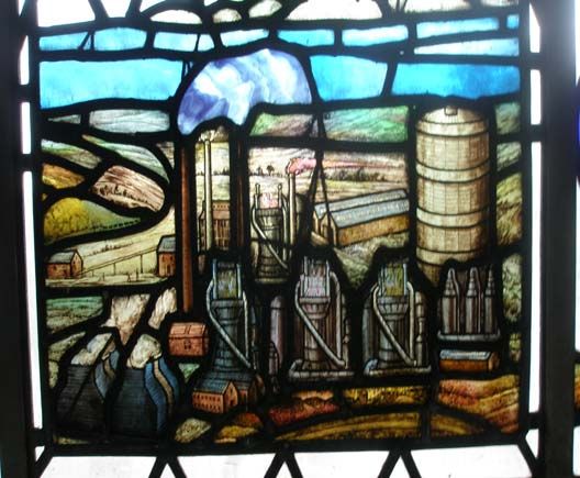
Thoroughsale Road
             o Spinney Grove
             o Lodge Green Road
          Westfields Road
             o Upperfield grove
             o Shrubfield Grove
          Tanfields Grove
             o Chapman Grove
             o Sarrington Road
          Studfall Avenue (north side)
             o Roundabout
             o The OpenHearth Public House
             o Studfall Avenue (south side)
             o Gray’s Close
          Thoroughsale Road
             o Waletts Close
             o Ollis Close
          Studfall Avenue (north side)
             o Clarke Road
          Rowlett Road
             o Clifton Square
             o Irving Grove
             o Tanfields Grove
          Studfall Avenue
             o Western End Addition to CA
             o St. Columbas & the Northern Saints C. of E. Church
             o Interior
             o Pentecostal Church
             o The Parade of Shops
             o The Rockingham Arms

4   Assessing special interest

    4.1   Location and setting
          Location and context
          General character and plan form
          Landscape setting

    4.2   Historic development and archaeology
          Origins and historic development of the area
          Archaeology and Conservation Areas, including scheduled
          monuments

    4.3   Spatial analysis
          The character and relationship between spaces in the area
          Key views and vistas

    4.4   Character analysis
          Definition of character areas, activity, prevailing and former uses
          Architectural and historic qualities

                                    3
Listed buildings
          Contribution of key unlisted buildings
          Local details: Building materials and public realm
          Boundaries
          Greenspaces; ecology and biodiversity
          Extent of intrusion or damage
          Neutral areas
          General condition
          Problems, pressures and capacity for change

5    Community Involvement

6    Suggested boundary revisions

7    Local generic guidance

8    Summary of issues

9    Glossary

10   Bibliography

                                   4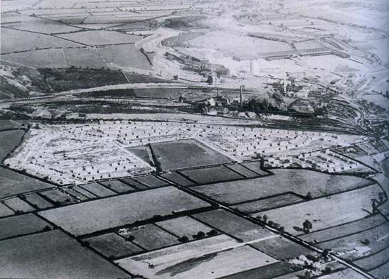
Introduction

   Within the Borough of Corby nine Conservation Areas have thus far been
   designated. The Corby Local Plan (1997) Paragraph 7.1 states that “there is a
   sharp contrast between the modern environment of Corby Town and the
   historic and traditional character of the villages. Seven Conservation Areas
   have been designated” A further two were designated in 2007. These are
   listed below with the date of the designation:

   Ref   Location

         Conservation Areas

   CA1   Great Oakley (1968)
   CA2   Gretton (1970, 1987)
   CA3   Rockingham (1970)
   CA4   Cottingham (1975)
   CA5   Middleton (1975)
   CA6   Lloyds, Corby (1981)
   CA7   Weldon (1988)
   CA8   Stanion (2007)
   CA9   Corby Old Village (2007)

   ‘The North Northamptonshire Local Development Framework (LDF), Corby
   Borough Site Specific Proposals Preferred Options Development Plan
   Document’ was published in May 2006, providing details of how Corby should
   be developed up to 2021. The North Northamptonshire Core Spatial Strategy
   was submitted to the Secretary of State in February 2007 and has just
   completed the examination in public process prior to adoption. This is an
   important part of the policy framework referring to the protection and
   enhancement of built and natural resources. It is the overarching policy
   framework for this part of the region.

   ‘A Heritage Strategy for Corby Borough’ was published in February 2006; this
   is referred to in paragraph 3.233 of the Corby Borough Site Specific Proposals
   Preferred Options Development Plan Document.

   In February 2006 English Heritage published their latest guidance on
   Conservation Area appraisals and management plans in order to offer “advice
   to those undertaking or commissioning Conservation Area appraisals” so as
   to ensure a certain amount of consistency to such appraisals across the
   country, and that they were fit for purpose. The Heritage Lottery Fund insists
   that all applications for Townscape Heritage Initiative grant funding for
   Conservation Areas should be accompanied by new up to date Conservation
   Area appraisals in line with English Heritage’s latest guidance

   This then provides the background to this present Conservation Area
   Appraisal and Management Plan for the Lloyds Conservation Area
   commissioned by Corby Borough Council (CBC) in August 2007 from a

                                         5
specialist historic buildings consultant. This document follows the latest
advice of English Heritage contained in the guidance leaflet “Conservation
Area Appraisals” (English Heritage, 2006).       This new Appraisal and
Management Plan form the Lloyds Conservation Area Appraisal and
Management Plan. This follows the advice contained in “Guidance on the
management of Conservation Areas” (English Heritage, 2006).

The Lloyds Conservation Area Appraisal and Management Plan will be a
material consideration to inform planning permissions in the future, and
emerging planning policy.

                                    6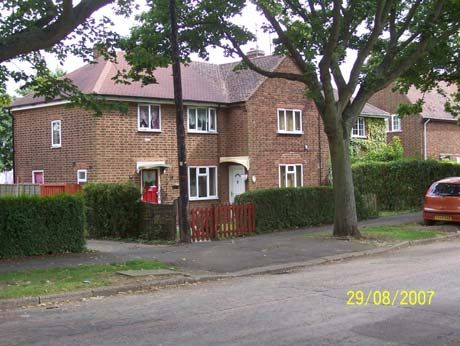
Part 1 – Conservation Area Appraisal
1        Introduction
1.1 This appraisal is a statement of the special architectural or historic interest
of the Lloyds Conservation Area, Corby. It is provided to inform the
management of the Conservation Area and, in particular, the formulation of
policies, the determination of planning applications for development, and
proposals for enhancement.

2        Policy context
2.1 The key government guidance on all development affecting historic
buildings, Conservation Area and sites of archaeological interest remains
Planning Policy Guidance Note 15 (PPG15) Planning and the historic
environment (1994) and Planning Policy Guidance note 16 (PPG16)
Archaeology and Planning (1990), until these are rewritten as a new Planning
Policy Statement (PPS). The legislation to which this guidance primarily refers
is the Town and Country Planning Act 1990 (‘the Principal Act’) and the
Planning (Listed Buildings and Conservation Areas) Act 1990 (‘the Act’)

2.2 Section 69 of ‘the Act’ requires local planning authorities to designate as
Conservation Areas any “areas of special architectural or historic interest the
character or appearance of which it is desirable to preserve or enhance”.
Also, from time to time authorities are required to review the extent of
Conservation Areas within their districts.

2.2 Section 71 of ‘the Act’ requires local planning authorities to formulate and
publish proposals for the preservation and enhancement of Conservation
Areas and to submit them for consideration to a public meeting. Following
designation the local authority, in exercising its planning powers must pay
special attention to the desirability of preserving or enhancing the character or
appearance of the Conservation Area (Section 72 of the Act).

2.3 The Milton Kenes and South Midlands Sub-Regional Spatial Strategy and
the North Northamptonshire Core Spatial Strategy form the higher tier policy
background which will superseeds the Corby Local Plan (adopted June 1997).
This Local Plan contained some Environmental Policies for the ‘Conservation
of the Built Environment’ that will be saved policies within the present
proposals.

    •   Policy P3 (E) concerned with the preparation of enhancement schemes
        in Conservation Areas.
    •   Policy P4 (E) concerned with the protection of Listed Buildings and
        their setting, with a presumption against demolition. Development
        schemes to take account of unlisted buildings of interest.

2.4 ‘The North Northamptonshire Local Development Framework (LDF),
Corby Borough Site Specific Proposals Preferred Options Development Plan
Document’ (May 2006) also has ‘Policies for the Built Environment’:

                                        7
•   ENV 3: Preferred Options for the Protection of the Built environment.
        Concerned with the development of a general policy to support the
        protection of Scheduled Ancient Monuments and Conservation Areas.
    •   ENV 4: Preferred Options for Design Guidance. Concerned with the
        development of design guidance as a Supplementary Planning
        Document
    •   ENV 5: Preferred Options for Conservation Areas. Provides a
        commitment to appraise existing Conservation Areas, and to consider
        designation of new ones and the production of management plans.
        This Conservation Area (CA) appraisal of the Lloyds CA accords with
        this policy

2.5 This is in accordance with the slightly earlier Heritage Strategy for Corby
Borough (February 2006) that provided an Action Plan for identified projects.
Action No. 4 of the Plan is concerned with Corby Conservation Areas, the aim
of which was:

    •   To undertake character appraisals of the 7 designated Conservation
        Areas and develop management proposals for them as required.
    •   To explore the possibility of Corby Old Village and Stanion becoming
        Conservation Areas. These were surveyed in 2007 and have since
        been officially adopted as Conservation Areas.

The proposed action needed to implement the above was identified as:

   •    Begin character appraisals in 2006 (2 per year). Completed by 2010.

In 2007 to 2008 the Lloyds Conservation Area was selected as the first of the
existing Conservation Areas to be subject to a detailed survey by a specialist
conservation consultant, which resulted in proposals to enlarge the existing
boundary.

2.6 The performance of Local Authorities is judged by Government by various
Best Value Performance Indicators (BVPIs). A new one for Conservation
Areas was introduced to cover the year 2005 to 2006, BVPI 219 a) b) and c).
The requirement was reduced for the period 2007 to 2008 for Local
Authorities to comply with the requirement of only BVPI 219b; this was to
encourage local authorities to undertake appraisals of their existing
Conservation Areas which many authorities had complied with, though few
nationally had been able to produce management plans of their Conservation
Areas, as required in BVPI 219 c) during the initial period, and this may be the
reason why that requirement was dropped.

BVPI 219 b) – Preserving the special character of Conservation Areas.
The specified purpose and aim of this is stated as: “The Planning (Listed
Buildings & Conservation Areas) Act 1990” imposes a duty on local authorities
to designate as Conservation Areas any ‘areas of special architectural or
historic interest, the character or appearance of which it is desirable to
preserve or enhance’.

                                       8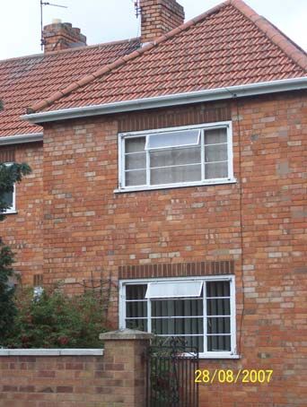
Description:
   • BVPI 219 b) Percentage of Conservation Areas in the local authority
       areas with an up-to-date character appriasal.
It also states that “clear and concise appraisals of the character of
Conservation Areas provide a basis for their designation and management,
and will inform Local Development Documents (LDDs).”

The initial guidance stated that “BVPI 219 a, b & c indicator will monitor
whether planning and other decisions are based on an informed
understanding of the special character of the local historic environment and
the needs of the communities it supports”.

3       Summary of special interest

3.1     The Confines and Boundary of the Conservation Area

3.1.1 The Lloyds Conservation Area (CA) is to the north west of the modern
town of Corby and is approached up Rockingham Road. The two main entry
points to the Lloyds CA run off Rockingham Road to the west: Occupation
Road that existed before the housing estate was built by the steel firm
Stewart’s & Lloyds in the 1930s, and Studfall Avenue that cuts across the
estate east to west. Set between these two roads are two principal roads that
run north to south: Thoroughsale Road to the west, and Tanfield Grove to the
east that crosses Studfall Avenue with a large roundabout at the road
junction, the only one within the CA, and continues northwards to form a link
with Rowlett Road that runs east to west across the top of the CA. In addition
there is a small area to the south of Occupation Road that runs along West
Glebe Road. These roads form the main structure of the housing estate and
have a number of cul-de-sacs that run off them to both sides, mostly called
“Grove” or “Close” with one larger “Square” with houses built on all sides, the
cul-de-sacs being of various generic shapes the access road being straight
then meeting an elongated oval or round island sometimes referred to as a
“frying-pan handle” or “hair-brush handle” cul-de-sac, the houses being built
around a central grassed island some of which are planted with trees.

3.1.2 The original Conservation Area was restricted to the workers’ housing
only and excluded the contemporary 1930s shops built along Occupation
Road, and the various churches built for the different denominations: the
Church of Scotland, Catholic, Baptist, Church of England (C. of E.) and
Pentecostal that were built mostly on the edges of the estate. The CA has
been extended to include these churches and the shops, including the long
parade of 1950s shops built on a curve at the west end of Studfall Avenue,
and the Rockingham Arms just beyond it, together with the large area of open
green space, opposite the public house, that was used for a weekly open-air
market prior to the building of the New Town centre. In addition the new CA
boundary also includes Rutherglen Road that runs off to the south off
Occupation Road which appears to be an early addition to the Lloyds estate.

                                      9
Also included on the southern boundary of the CA are the Allotment Gardens
and garage block off West Glebe Road, and the Roman Catholic Junior
School set behind the Catholic Church. They have all been proposed as an
addition to the CA boundary because of their individual merit and different
architectural style, being an essential part of the social history of the area both
temporal and spiritual.

3.2    Audit of heritage assets:
       Detailed Appraisal of the buildings

The Eastern Approach

Occupation Road:
3.2.1 The Lloyds CA is approached from the east by Occupation Road that
runs off the main Rockingham Road. On the north side of the road close to
the road junction is a sports ground that is not included in the CA with a
church and its church hall on the south side; these were not previously
included within the CA boundary, this commenced at the start of the houses.
The road is a wide boulevard with tarmac paths and strips of grass separating
them from the road; a number of hedge boundaries survive.

3.2.2 St. Andrew’s Church of Scotland

Setting: standing on the south side of the road the church fronts Occupation
Road putting its north side into prominence. The boundary is defined by a
dwarf stone wall with simple rod railings with dog-bars backed by a hedge that
grows through the railings in places. Set within its churchyard are a number of
variegated trees with taller trees forming a barrier to the eastern boundary by
the church hall; this gives a feeling of enclosure around the church and hall.
Before the porch the path is inlaid with an attractive circle of stone sets the
path surrounded by flowers.

Architecture: the church is a simple traditional stone building built of Weldon
stone faced in ashlar with a Swithland slate roof. It has a nave and chancel
with transepts, gabled on the north side with a tall narrow window with arched
heads with hood-mould, the nave with 2 bays of similar 2-light windows. The
gabled porch on this side defines its simple Norman style featuring coupled
colonettes with a semi-circular arch of two orders. Set within its tympanum is
an attractive foliated carving of the burning bush taken from the Old

                                        10
Testament with above the door the Latin inscription “NEC TAMEN
CONSUMEBATUR” and a shield carved with a St Andrew’s cross. Its west
gable has a 3 light window and a bell under a gabled open roof. It is a
charming simple church largely preened of ornament built on the edge of the
original settlement to meet the needs of its Scottish immigrant workers at the
Stewarts & Lloyds steel works close by. The windows are simply glazed with
an attractive mix of small coloured glass set in leaded lights, protected
externally by sheets of polycarbonate.
Interior: Nave with shallow side aisles, transepts and Chancel with small
Sanctuary recess framed by interlinking arches of a Romanesque arcade with
canopies to either side over the simple oak octagonal pulpit that matches the
simple oak pews and parquet wood floor.
History: the foundation stone was laid July 7th 1938 by the Moderator of the
General Assembly of the Church of Scotland and was built to serve the needs
of the large Scottish population who had come to Corby seeking work. It was
constructed by Bowman’s of Stamford. When it was built the church was the
only Church of Scotland in the Midlands, the nearest other church of this
denomination being in London; this attracted large congregations from all over
the County.
The Church Hall: to the east of the church the Church Hall is a simple brick
structure built of a creamy-yellow brick, toning with the colour of the stone of
the church. It has five bays of windows with wooden panelled aprons, the
entrance set in the west gable end of the building that has a tiled roof.
11Interior: some 60ft long by 25 ft wide the hall is divided into 5 bays by large
trusses constructed of re-enforced concrete like full base-crucks with 6
chamfered purlins, and has a stage at the east end. The foundation stone was
laid by the Duchess of Gloucester on 3rd June 1956 the hall opening on 16th
December 1956.
3.2.3 Occupation Road (north side): opposite from the church are a row of 6
new brick houses built in 2007, their design and the colour of the brickwork
blending with the existing buildings in the Lloyds CA; these are not included
within the CA boundary.
3.2.4 West Glebe Road: this runs south next to the church and creates a U-
shaped road that runs back on to Occupation Road the middle of the U filled
by two back-to-back cul-de-sacs much like a frying-pan handle seen
throughout the CA. Two mature trees stand either side of the road with similar
trees flanking the road junctions with the crescents. This particular road has a
lot of mature trees lining its edge, these add greatly to the character of the
CA. The initial houses are semi-detached; some are a full 2-storeys while
some are lower 1½-storeys with paired dormers rising through the eaves that
make them more like cottages. There are also longer groups of three houses
with front-facing balanced wings. Here, almost universally, the original privet
hedge boundaries to the gardens of the houses survive intact.
3.2.5 A number of houses retain interesting
entrance gates e.g. no.16 at the entrance to
Springfield Grove that features a typical
1930s ‘sunburst’ Art Deco design to its side
gate and double garage gates.
3.2.6 On this Grove is a mix of housing that is repeated in a similar formation
throughout the rest of the Lloyds Estate: 2-storey semis with hipped roofs
(nos. 1 & 3 and opposite nos. 2 & 4), larger U-shaped blocks with 2-storey
end wings with front facing hipped roofs
with lower 1½-storey centres with
central paired door-cases and roof
dormers (all renewed and recent);
these form 4 dwellings (nos. 5-11 and
nos. 6-12) on either side of the road,
with a similar arrangement at the head
of the cul-de-sac (nos. 18-24) that are
flanked on either side by smaller 1½-
storey semis. (nos. 13 & 15 and nos.
1214 & 16) that have simple gabled roofs and paired windows rising through the
eaves as raised dormers.
There are five identifiable different groups of buildings observed on the estate,
that can be identified as groups A, B, C, D and E;
• A a pair of hipped roofed semis.
• B a U-shaped group of 4
• C gabled cottage type
• D 3 house block with central projecting gabled wing that forms a
separate house
• E a pair of semis with paired front facing gables to the centre with an
angled chimney set between the gables
The road runs around a thin central island of grass with a single tree, the
island with curved ends. Another distinctive feature is the telegraph poles with
cables fanning out like a giant cob-web serving the buildings on the close.
Each of the buildings has a garden to its front, though some have been used
for off-street parking. Above the entrance doors to the houses are two types of
hoods: type 1 a flat cornice supported on curved modillion-shaped brackets
constructed of cast-concrete and sometimes painted; type 2 is more simple
with a one-piece moulded segmental-shaped painted steel hood; these can
stand side-by-side e.g. no.3 West
Glebe Road type 1, nos. 3 & 5
type 2. An example of type D is
Nos. 9, 11 & 13 West Glebe
Road with a similar building
opposite (nos. 20-24) with a type
1 hood and two type 2; it’s quite
clear from the changing brick
colour above the 3 hoods that
they are a later alteration;
however, they add variety to the
street scene and house types.
3.2.7 Set between nos. 1 & 1a is the remains of a redundant footpath that
retains its entrance, a sturdy iron fence and gate with octagonal columns
bearing the casting mark of “Hayward & Sons, Wolverhampton”. Another
interesting piece of street furniture is an electricity box with hinged double
doors and pyramidal roof bearing a circular disc embossed with a capital “B”;
a number of there are to be observed strategically based on the edge of the
road throughout the estate. However, they are probably redundant as close by
is smaller green-painted metal box set against the hedge boundaries, each
displaying a different number e.g. “C00 82-02”. At the head of the road
discretely positioned are two brick blocks of 10 garages with a distinctive
1930s parapet with a raised flat centre. These garages stand close to the
allotments which have a former timber shed, now clad in metal its gable
bearing the name “The West Glebe Shop” that was associated with the
allotment members. Sturdy gates secure the allotment grounds which are
13extensive and still in productive use with many vegetables growing in neat
plots. The dense trees on the southern boundary form woodland.
3.2.8 On the western return of the road, a number of trees have been lost
changing the character to a more open lighter feeling. Highfield Grove has
an identical grouping of buildings to Springfield Grove; no. 12 has suffered
stone cladding and render, damaging the integrity of the group. Set between
the entrances to West Glebe Road are a dozen blocks of mainly 2-storey
semis with hipped roofs (type A) with one type D in the middle. This provides
consistent rhythm and emphasises the length of the road.
3.2.9 Occupation Road (north side): By contrast, the houses on the North
side of the road form a distinct
group of 9 larger 3 and 4
bedroom detached houses
(nos.2 -18), the only ones
within the Lloyds CA; an early
aerial photograph of the
building site shows that these
were the first properties to be
built, perhaps to house senior
staff. They are double-fronted,
with rooms to either side of
the central door having canted
bay windows, being built with
brick walls the upper floors
with a band of render the roofs being hipped. Nos. 2 & 4 appear contemporary
unique 1930s one-off designs of similar type: no.2 is L-shaped with rendered
front facing gabled wing; it also has unusual kneelers formed by stacked thin
tiles supporting its gables.No.4 has a 3-bay front with a hipped wing to the left
incorporating an original garage with hinged doors the upper sections part
glazed. Nos. 6, 8, 10 & 12 are 4 double-fronted detached houses with hipped
roofs having 3 upper floor windows and canted bays to either side of the
central door; no. 10 retains its original part-glazed door. No. 14 is different
with a garage extension, but with the door altered as no.4. The ones with
garages are the 4 bedroom properties, the others being 3 bedrooms. Ns. 16 &
18 also have 3-bay fronts as nos. 6-12. No. 14 is reported as having a Second
World War bomb shelter still surviving in its garden.
3.2.10 Westfields Road: runs off
to the north with a pair of semis set
at an oblique angle facing the road
junction example type E. The view
down the road shows a magnificent
vista of trees surviving on the edge
of the road.
143.2.11 Further along the south side of the road is an arcade of shops,
contemporary with the original Lloyds development; the two blocks built on
either side of the Rutherglen Road are brick built with hipped red tile roofs.
The shop windows are defined by planted-on brick pilasters with vertically
bedded tops still visible behind roller-shutter blinded shop fronts. One of
these, a Co-op supermarket appears to retain its original 1st floor glazing to its
windows – small-paned glazed casements painted white; this building also
retains its original tall chimney stacks.
3.2.12 Rutherglen Road: leads off to the south and appears to be an early
addition to the Lloyds estate. For the most part the street uses two building
designs: one featuring twin gables to the centre with projecting ‘wings’ with
lean-to open-fronted porches with arched heads to either side.
Contrasting with this strongly gabled design is a hipped roof semi’ design with
planted-on door cases, originally with an open recessed entrance set within a
semicircular archway – most have been in-filled, but no. 27 with its neat
hedge boundary preserves its original form. Set between the doors are canted
bay windows linked with a continuous lean-to roof with hipped ends. The
disposition of the trees (flowering cherries) is of interest in that they appear to
have been carefully placed at the centre of the hedged boundaries between
adjacent properties, but less than half survive. Facing the street on the main
road is a variation of the T-shaped design having a hipped roof instead of a
gable.
3.2.13 Tanfield Grove: running off to the north features two housing types
visible from its entrance, the twin gable half rendered and 1 ½ semis with
dormers (a possibly new type). The most distinctive feature on the road is the
large multi-storied water tank set within an island. The tower creates a short
view but the road continues across the width of the CA running north to south
to the large roundabout next to the Public House; the water tower is supported
on square columned legs, a utilitarian object of great power in its brutalist
design an icon of its period (1930s).
3.2.14 The Roman Catholic Church of Our Lady of Walsingham: the
church and its presbytery stand on the south side of the road just after the
parade of shops. Hidden away behind the church is its school; these form a
distinct and important group in this proposed addition to the CA. The church
15built of brick appears is orientated NW to SE and is T-shaped with the arm of
the presbytery attached on the west side, both built of a golden-yellow
coloured brick softened by pollution. It is a modern church featuring the saint
of its dedication above the gated entrance, but below the window is a carved
stone relief of the Virgin and Child. Attached on to the NW corner is a tall
square tower with three belfry openings close to the top.
Interior: Nave and shallow side
aisles of 5 bays divided by tall
fluted columns that support the
unusual saw-tooth profile of the
cast-concrete ceiling. Set above
the north entrance is a carved
stone plaque with a tall stained-
glass window above; the bottom
panel of the window illustrates
the steel furnaces of the Lloyds
Iron Foundry.
Setting: the church forecourt is
enclosed by brick walls with piers
and unusually decorated
distinctive Art Deco railings
appearing again to the street
frontage of the presbytery (no.
71).
16This is a 3-bay 2 ½-storey simple Queen Anne revival style house typically
with dormer roof lights and gable-end chimney stacks. It has a small but
tranquil garden featuring a white marble statue of Our Lord, the garden
bounded by a privet hedge. Curiously the presbytery is attached to the church
by the former garage, once a separately detached building with a later
extension joining them up.
3.2.15 Our Lady of Walsingham Catholic Primary School: beyond a pair of
shops a road leads down to the entrance to the school. This like the church is
a strikingly modern design with a raised classroom on concrete columns
under which one travels to the main entrance. A date plaque set in a single-
storey range bears the date “Anno MCMXLV” (1945), an unusually early date
for such a school that incorporates concrete, flat roofs and brick walls, more
typical of the 1950s and 60s; a striking feature of the design is the tapering
circular boiler-house chimney. The present entrance is contained within a
separate block to the south, flat roofed, probably later 1960s.
3.2.16 Woodfield Grove, off Occupation Road (north side): this is a short
frying-pan handled cul-de-sac of houses of similar designs to elsewhere in the
CA: at the entrance twin gabled semis facing each other set behind mature
curving hedges, and longer T-shaped blocks of 5 houses with hipped roofs
also facing each other. At the head of the road a 3-house gabled T-shaped
block, flanked by 1 ½ -storey semis with dormers set at an oblique angle
facing the curve of the road. Here, the survival of trees in the central small
island is greater than usual with 4 trees that act as a screen providing privacy
between the larger blocks that are opposite each other.
3.2.17 Westfields Road: is a principal
road leading through to Lodge Green
Road that runs parallel to Occupation
Road further to the north. It has the
now typical half rendered twin gabled
semis set at an oblique entrance to the
road junction, the houses set behind
privet hedges; no. 137 has a rather odd
corner extension. Some tree thinning
along the road that is lined with a mix of
1 ½-storey dormer cottages and 2-
storey T-shaped blocks with gabled
and hipped roofs.
173.2.18 Negative development: on the south side of Occupation Road
(outside the CA) a new building on Ashdown Place has been built in sympathy
with the cottage style of the buildings within the CA contrasting with the 3-
storey Forest Gate that is both out of scale (too tall) and sympathy with the
domestic houses opposite.
3.2.19 Addition to the CA boundary: further east Forest Gate Road has a
splayed entrance providing a generous well wooded and grassed area that
has been brought in to the boundary of the CA; the trees add to the setting of
the houses on the opposite side of the road, within the CA.
3.2.20 Occupation Road (nos. 44-66) here are 3 blocks of 4 houses U-
shaped with hipped end wings. Further east (beyond Thoroughsale Road) are
two more blocks of 4 marking where the original Lloyds houses terminated
and the extent of the CA boundary. Beyond these are buildings of different
character Airy homes – built as temporary Post-war dwellings.
3.2.21 Thoroughsale Road: like
Westfields Road also forms a link through
to Lodge Green Road. Of particular note
and interest is No. 5 that retains its
original window glazing that provides a
strong horizontal emphasis with canted
bay windows on the ground floor featuring
4 panes and a top hinged casement, the
1st floor windows divided into 3 panes with
side hung casements. Its front door has 3
vertical timber panels and a square
glazed panel in the upper part of the door.
3.2.22 Spinney Grove: leads off to the west and is a short frying-pan shaped
cul-de-sac featuring 5 housing blocks: a block of 4 with end hipped roofed
wings facing down the road, the other 4 blocks being the same semi-detached
cottage type with paired dormers rising through the eaves; no. 2 still retains its
original glazing and front door to the upper glazed section that is subdivided
into 6 panes.
3.2.23 Lodge Green Road: runs E-W across the CA with three cul-de-sacs
running off on the south side. Negative feature: no. 20 is one of the worst
cases of stone cladding in the CA having yellow colour cladding on a central
projecting gable. The road changes its name further to the east and is a
continuation of Westfields Road; this is opposite nos. 130-142 that is an
attractive group of 3 housing blocks set back from the road with longer front
gardens arranged around a shallow curve set at an oblique angle the houses
featuring part rendered twin gables. These are balanced by similar houses on
the opposite south side of the road that are set at an oblique angle to the road
18junction (nos. 144, 146 & nos. 87 & 89). No. 93 is one of the few buildings in
the CA that retains its original glazing and doors to both its front and side
elevation, and provides a good impression of how the buildings looked
originally. Cottage-style semis with roof dormers; close by no. 152 also retains
its original glazing, but its door has been altered.
3.2.24 Upperfield Grove: has its
central island without trees and looks
very bare. No. 17 retains double-
gates of an unusual design
incorporating a sunflower design.
No.6 too has an unusual entrance gate
featuring S-scrolls with a sun-burst arched
top (typical of the 1930s). Opposite the
entrance to the Grove is one of the few
examples in the CA of painted brickwork
(painted a brown/red) that detracts from the character of the building.
Shrubfield Grove further along retains a few trees in its island that add to the
setting of the houses.
3.2.25 Tanfields Grove: is an important
link road leading from Occupation Road
through to Westfields Road and on to
Studfall Avenue and Rowlett Road on the
northern edge of the CA. Just before the
roundabout at the road junction on Studfall
Avenue Chapman Grove is a cul-de-sac
with a fine mature Willow tree on the corner
in the garden of no. 53 Tanfields Grove that
adds significantly to this part of the CA. No.
11 Chapman Grove has cream-painted
brickwork.
3.2.26 Sarrington Road: opposite forms an L-shaped road leading through to
the NE end of Studfall Avenue. Set within the elbow of the “L” is a small
children’s playground accessed via a footpath from both roads; the boundary
with the adjacent properties is fenced off with tall clapper-boarding.
193.2.27 Studfall Avenue roundabout: at the junction with Tanfields Grove is a
large grassed roundabout. On the NW side of the road facing onto the
roundabout is The Open Hearth Public House being the first Post War
licensed house erected in the county of Northamptonshire in the 1950s as its
foundation stone informs us.
It is a well proportioned building being of 5 bays with a 2-storey centre under a
hipped roof with lower single bays set back to either side. Its entrance doors
are set either side of a central window in a planted-on section that features
channelled rustication. It is enclosed behind a hedge boundary with trees to
either side having a painted sign set before it featuring steelworkers stoking a
furnace – hence the name. The inn was largely unaltered retaining small-
paned timber glazing at the time of the survey but was closed for
refurbishment in the autumn of 2007. Close by on the edge of the roundabout
some new building is evident: nos. 71a & b, and Kane Walk, a modest single-
storey sheltered housing scheme. As the traffic island does not have any tree
planting on it the public house closes off the oblique views at the road
junction.
3.2.28 Studfall Avenue: leads off to the NE to a mini roundabout on
Rockingham Road that is just outside the CA boundary. Along this section of
the road no original trees survive, but a recent planting of Silver Birch saplings
provides a uniform character that will differ from other areas of the CA. The
western section of the road from the roundabout has similar saplings. Gray’s
Close: is a cul-de-sac that leads off to the south and has a circular island
turning circle inset with a single tree; it is virtually at the centre point of the
planned development. Further along
to the west Thoroughsale Road runs
off to the south; it has two cul-de-
sacs (like hair-brush handles)
opposite one another; that to the
west, Waletts Close is the only cul-
de-sac where the buildings are not
aligned to the curved end; this gives
the gables of nos. 11 & 12 greater
prominence.
20Ollis Close opposite follows the usual arrangement of houses aligned at the
corners; one of them (no. 17) has an unusual gate featuring a cob-web design
3.2.29 Thoroughsale Road: the many
surviving tress along the road are
amongst the most attractive in the CA
having a mix of species including
Copper Beech that add significantly to
the character of the area. This
contrasts with Clarke Road that runs
off Studfall Avenue to the north, where
the trees have been either removed or
subject to a severe pruning the
pollarded trees forming ball heads.
3.2.30 Rowlett Road: Clarke Road runs onto Rowlett Road that is the
northern most E-W cross road in the CA. Built on the south side next to the
junction with Darley Dale Road is Corby Baptist Church, a striking 1960s
design with an unusual sloping pitched roof, lower at its rear, rising to its cut-
off entrance corner that features a projecting roof hood and a floating slab
over its entrance. It is built of a light mottled cream brick with deep full-height
steel framed windows inset with blue panels that define the level of the
gallery. Next to its entrance a foundation stone records that it was laid by
W.J.A.Peck on 2nd July 1966 opening in June 1967.
Apparently within the central area of Northamptonshire there are 6 similar
churches all designed by the same architect. Next door to it is the earlier
Baptist Hall of 1950, a more utilitarian building. Within its grounds are a
number of mature oak trees that form a significant group with another set
before the hall that is thought to be 40 years old. To the east a number of
trees have been pollarded in the past but are now recovering; the trees on
Latimer Road have survived better.
213.2.31 Clifton Square running off to the south off Rowlett Road is the largest
of the frying pan handled cul-de-sacs with a grassed island within the CA; it
has a long rectangular strip of grass of a similar size to a foot-ball pitch; only
one Silver Birch tree survives with another dead tree. This is the nearest to a
village green in the whole of the Lloyds development, but it has a bare and
barren look and feels a little soulless.
The arrangement of the housing blocks is more uniform featuring only two
designs, being either T-shaped with a central gabled wing for 3 houses, or a
U-shaped 4 house terrace with end wings with hipped roofs. Negative
features: one of the houses (no. 42) has suffered stone cladding. Nos. 1 & 3
has lost their front boundaries to permit off-road parking. However, no. 1
retains its tall neatly trimmed hedge on the curving entrance to the square.
3.2.32 Irving Grove: further to the east, beyond Tanfields Grove that leads
back to the roundabout on Studfall Avenue, Irving Grove is another cul-de-sac
with a central island, this one retaining 3 mature trees. Here there are
groupings of 4 different house types – light coloured brick semi-cottages with
central paired dormers rising through the eaves being the dominant type. The
neatly trimmed hedge boundaries of the gardens reinforce the curving shape,
especially outside no. 1. Negative features: elsewhere many have lost their
hedge boundaries and are open to the street with gravel parking areas, one
with a concrete slab (no. 21) is particularly damaging.
22Also damaging to the character of the area are the external drainage pipes to
the front of no. 7, obviously serving a new bathroom – but none of the other
houses in the CA have been altered in this way. Also damaging is the stone
cladding to the front facing gable of no. 4. Set at the junction with Rowlett
Road, no. 75 has had its boundary replaced by a post-and-rail fence its
garden covered by gravel. In addition the brickwork of the house has been
painted a dark red with contrasting grey corners, the house having the
inappropriate addition of a porch on white columns. It stands in stark contrast
to the other properties within the CA particularly to its neighbour no. 77 on the
opposite side of the road that retains a neatly trimmed hedge with an arch
carried above its entrance gate. The car-port added to the side of no. 90 is
also an undesirable suburban intrusion. The boundary to no. 80 has been
replaced with broad horizontal planks that are also an inappropriate alteration.
3.2.33 Tanfields Grove: further east runs off to the south and provides a long
view across the roundabout, the trees framing the view. A similar fine avenue
of trees runs down the side of Rowletts Road with a short view created by a
bend to the east. Round the corner of the bend, outside no. 28, 3 trees have
been lopped or turned into a stump. No. 21 retains a good example of an
original door – but the house has been damaged by the external plastic pipes
for a bathroom. A path down the side of no. 6 leads to a playing field that has
some children’s play equipment set to either side of a diagonal path across
this attractive green grassed area that is bounded by tall hedges and mature
trees in the rear gardens of Wharfedale Road just outside the CA. It provides
an important area of green space and a recreation ground for the local
children. It is one of 39 play areas in Corby district that are subject to weekly
clean-up and equipment checks.
3.2.34 At the junction off Rowlett Road with Studfall Avenue the properties set
across the angle are bounded by neatly trimmed hedges that reinforce the
angle and the road junction.
The mature trees on Rowlett Road contrast with the tree planting on Studfall
Avenue that are relatively young Silver Birch saplings commented on above.
233.2.35 Studfall Avenue – Western end Addition to the CA: here is a
parade of shops and a public house all built on the north side of the road, with
a church, hall and vicarage on the south side that it is proposed to add to the
CA. St. Columbas & the Northern Saints C. of E. Church is an unusual
design, built in 1957 by G.Dodson & Sons, being modelled on Coventry
Cathedral, placing its tall 65ft high square tower between the Nave and the
North Transept, with a squinted entrance placed across the angle providing a
north Porch.
The body of the Nave has 8 long
windows set into angled
recesses that give the
impression of buttresses
supporting the over-sailing
shallow-pitched copper-clad roof,
which tilts to the west where
there is a projecting porch with stepped
recessed orders of brickwork recessed to a
stone cross forming a cross-mullioned
window above the double entrance doors that
are Spanish style stained chestnut.
The Tower has the outline of a cross in raised
bricks, on the north side, and a Belfry with
arrow-slits on the west side. The North
Transept is lower with 5
small window bays – used
for church offices – under a
single mono-pitched roof;
the east side has 3 belfry
slits. Beyond the tower the
Chancel is coffin ended in
shape with a tall cross
window in stone. Interior:
the ceiling slopes down
towards the altar in a
dramatic fashion, but much
of the effect has been
spoiled by the insertion of a
part-glazed screen (in the 1990s) as a cost cutting measure on the heating.
Formerly a large stainless-steel cross hung above the Chancel steps set on a
raised dais, and the cross window is now covered by a curtain used as a
backcloth obscuring the date 1957. The Church Hall (built later) to the east
has a simple broad gable end facing the road with a vertical slit for the
24recessed doorway. The Vicarage (no. 157) has a distinctly French Regency
fell with its over-sailing hipped copper-clad roofs, and its massing with T-
shaped end wing and single-storey flat-roofed attached block. The boundary
wall is constructed from matching brick and is backed by a neat low trimmed
privet hedge, which once was much taller and screened the dwelling. The wall
continues and encloses the churchyard, but is here backed by 5 attractive
mature trees with low crowns that form a distinct division to the road and the
shops opposite with their hard-edged canopy.
Beyond the Vicarage stands the Pentecostal Church, a simple utilitarian
shed-like building with brick gable end and rendered sides and corrugated
concrete roof.
3.2.36 The Parade of Shops: with maisonettes (flats) on the two floors above
stands opposite the church and is an effective iconic 1950s design with
curved centre and set back end wings with tall stair windows with glass bricks.
It has 36 windows to the top floor with 24 larger window bays to the 1st floor,
every 3rd one having an open balcony. Built against the ends of the wings, a
curved single-storey range of 3 shop units with flat roofs inset with top glazed
lanterns. The central row of 12 shop units has a metal clad floating canopy
above with curved ends; the flats are entered from the rear via external
staircases.
3.2.37 The Rockingham Arms: to the west of the shops is the Public House
an attractive symmetrical design set behind a boundary wall.
25Opposite a public car park and a large grassed area with trees that gives the
impression of a village green that adds significantly to the setting of the
church and the character of the area; this area of land was once used for a
weekly market.
4 Assessing special interest
4.1 Location and setting
4.1.1 The Borough of Corby lies within the north-eastern area of
Northamptonshire and is approximately 20 miles from the centres of
Northampton, Leicester and Peterborough. Bounded by the Welland Valley
and pockets of the ancient Rockingham Forest, Corby Borough incorporates
seven rural villages that, as the Local Plan stated (in paragraph 7.1), form “a
sharp contrast between the modern environment of Corby Town and the
traditional character of the villages”. Corby is bounded by Weldon on the east,
Stanion and Little Oakley on the south east, Cottingham, Middleton and East
Carlton to the west, and by Rockingham and Gretton, to the north. In total it
contains 2596 acres. During the 19th century its population was 611 in 1801
rising to 797 in 1861 and falling to 699 in 1871. Corby lies on a Boulder Clay
plateau cut by a series of streams draining East and North-east; in the valleys
close by there are outcrops of limestone and marls. Corby village is on
limestone and marl, Upper Estuarine Series (17 ft to 45 ft deep) part of the
Great Oolite Series, also hemmed in by Northampton Sand Ironstone (0 to 22
ft deep) with an outer area of Boulder Clay. To the north of the village was
developed the huge steel works of Messrs. Stewarts & Lloyds with housing for
the workers initially built close to the works on the west side of the railway
26line, with a larger planned estate built further to the west off the Rockingham
Road to the north of Occupation Road – this was given Conservation Area
status by Corby Borough Council in 1981, known as “The Lloyds
Conservation Area”, and is the subject of this report.
4.1.2 The Development Corporation (1950) built a new town in Corby based
on ‘The Draft Master Plan’ produced in November 1951 by William Holford &
H.Myles Wright. This controlled the transformation of the area with many new
houses being built in response to the huge increase in population; the impetus
for this was the earlier discovery of improved methods of extracting the local
low grade iron ore to remove the phosphorus in its conversion to steel that
lead in the early 1930s to Corby becoming a steel town (see History section
4.2.12).
General character and plan form
4.1.3 The general character of the Conservation Area is that of a Garden City
Suburb with wide principal boulevards with grassed areas separating the road
from the footpath, planted with trees along its edge, with houses facing onto
the street; the general lay-out was detailed in section 3.1 ‘The Confines and
Boundary of the Conservation Area’. The grid-iron plan has two principal
roads, Occupation Road and Studfall Avenue that run east to west across the
area with another slightly minor road, Rowlett Road that runs off Studfall
Avenue close to the northern edge of the Conservation Area boundary. Shops
were built on Occupation Road, and Churches on all three roads built for
different denominations; these add architectural distinction to the area that is
dominated by semi-detached and terraces of workers’ housing. Particularly
The Church of Scotland at the eastern end of Occupation Road acts as a
gateway entrance to the housing development that starts beyond it. Cross
roads running north to south forge links between the main roads with similar
tree planting along the pavement edges. Secondary roads runs off these
cross roads terminating in some 16 cul-de-sacs, mostly called ‘Groves’, where
tree planting is confined to the grassed central islands that act as turning
circles for vehicular traffic.
Landscape setting
4.1.4 The general topography is fairly flat that was conducive to the building of
hundreds of houses. The land gently rises to the north above Studfall Avenue
and gently slopes down hill to the west along its length that adds to the views
into and out of the Conservation Area.
4.2 Historic development and archaeology
Origins and historic development of the area
4.2.1 Earliest Origins: The ‘Heritage Strategy for Corby Borough’ (2006)
suggests that “early settlement in the Corby area probably began in the
Bronze Age, and had developed significantly by the Iron Age, by which time
27the area was being farmed and exploited for its natural mineral resources.
When the Romans arrived they built a road linking Leicester with the Roman
town at Huntingdon which passed through what is now modern Corby. One
section of this road is a Scheduled Ancient Monument where it crosses Hazel
Woods. Another ancient road, Jurassic Way, crosses the Roman road
between Kingswood and Cottingham. These roads were probably a focus for
settlement, possibly a small Roman town. The Roman village at Little Weldon
and that to the east of Stanion (discovered in 2004) show that people of
wealth and high status lived in the Corby area for hundreds of years” until the
third century AD.
4.2.2 The 9th Century: A settlement was established in the area of Corby
sometime around 865 AD; the village name is thought to have been named
after a Viking leader called ‘Kori’ (see 4.2.4 below) who with his band settled
here. The tradition of the local Pole Fair and the ‘riding the stang’ (a Danish
word) may have originated from the Danish (Viking) custom of carrying
miscreants on a pole, carried by several men around the village, prior to their
punishment in the stocks or the pillory. Probably during this period of
integration with the local Saxon population a church was established in the
village prior to the Norman invasion of 1066.
4.2.3 The 11th Century: Soon after the Conquest William the Conqueror
established a castle at Rockingham that in part survives today and is an
Ancient Monument, and retained the manor and hundred of Corby as his own.
4.2.4 In 1086 Domesday Book provides our first documented evidence of
settlement at Corby, the town’s name derives from Old Norse “Koriby”
meaning ‘the homestead or settlement of Kori’. By 1086 the spelling was
“Corbei” (or “Corbie”) which also means ‘raven’. William the Conqueror held
the manor:
“In Corby Hundred
The King holds CORBEI. There are 1 ½ hides. There is land for nine ploughs.
In demesne is 1 plough and seven villains, with a priest and three bordars.
Between them all they have four ploughs. There is woodland 18 furlongs in
length and 4 furlongs in breadth. TRE (in the reign of Edward) was worth £2,
is now worth £10. Many things are wanting to this manor which TRE belonged
there in woodland and iron works and other matters.”
This provides a picture of a thriving agrarian community of around 20 families
living in a settlement at Corby. It is noteworthy that the value of the manor had
increased quite substantially; in other parts of the country the value went
down due to the laying waste of the countryside, especially in the North of
England, where it was known as ‘the Harrying of the North’. This indicates that
the Normans valued the area with arable land, its extensive woodland for
making charcoal for iron smelting, the iron works actually being mentioned.
The text also mentions a priest indicating the existence of a church before the
Conquest; fragments of a Saxon and Norman church still survive in part of the
west end of the south aisle and the north wall of the tower. The church is set
on a raised area of land bounded by a stone wall that has a distinctive curve
on its southern section, Saxon graveyards are usually raised and have
curving boundaries sometimes being oval in shape; it seems possible that the
28curved wall of the graveyard on the road side south front of the church may be
the original extent of its Saxon burial ground.
4.2.5 The Middle Ages: During the Middle Ages Corby and its seven villages
were part of Rockingham Forest that was a Royal hunting ground. Its ancient
woodland was to become central to its importance for the production of
charcoal for smelting the local iron-ore to make iron.
4.2.6 Tudor, Elizabethan and Jacobean times: During the 13th century the
Royal manor and hundred of Corby were granted to local baron, Robert de
Braybrooke for a rental of £8 that was reduced to 40s to be paid to the
exchequer twice a year, at Easter and Michaelmas. His son Henry succeeded
him in 1226 and secured the grant of a weekly market and two annual fairs,
around this time the church in Corby began to be rebuilt and enlarged. By the
early 14th century (1315) the manor and Hundred of Corby passed into the
hands of the Latimer family of Burton Latimer remaining in their hands until
the middle of the 16th century, until 1550, when it was transferred to William
the Earl of Essex and Marquis of Northampton; he was the brother of
Katherine Parr Henry VIII’s last wife formerly the widow of the 3rd Lord
Latimer. William was to support the interest of Lady Jane Grey and in 1553 as
a consequence his lands were forfeited to the Crown. The new Queen Mary
1st granted the manor to Edward Gryffyns of Dingley, for the annual payment
of £10. From his son Edward they appear to have passed to Sir Christopher
Hatton, a favourite of Queen Elizabeth and Lord Chancellor of England who
lived at Kirby Hall close by. He was a judge at the trial of Mary Queen of Scots
who was executed at Fotheringhay, not far from Corby. During the early 17th
century Robert Rich inherited Corby from the Hatton family owning the
Demesne land of Corby in 1616; he commissioned a map in 1631 showing his
landholdings. It then passed into the hands of the Brudnell (Earl of Cardigan)
family of Deene Park. The Brudnell’s are remembered in the village in the
name of the local public house, The Cardigan Arms, the hanging sign-board
displaying their heraldic coat-of-arms; by tradition this was where the tenants
paid there dues to the Lord of the Manor (both here and in Stanion).
4.2.7 Medieval Farming Practice: During the medieval period the three-field
system was the usual farming practice of crop rotation. A map of 1631shows
the arrangement of the open fields with above the village the North Field and
the West Field, with the South Field below the village; at this date there is no
East Field, but there was one shown on a later map of c.1660.
4.2.8 Enclosure: In 1795 the major landowners of the area, presented a bill to
Parliament for the enclosure of the open fields of several of the villages in the
forest area, bringing an end to the open-field farming in Corby. The legacy of
this was the large numbers of landless laborers, who had no land of their own
and had to work for the larger landowning farmers during the 19th century, this
led to diversification with many involved in exploiting the local timber
resources working within the timber trade as hurdle makers, wheelwrights,
carpenters and woodsmen and sawyers. In addition several worked as
handloom weavers, and their wives manufactured lace; many of their
daughters went into service working as servants for the local farmers and
gentry.
294.2.9 The Pole Fair & Charter Field: In 1682 King Charles II confirmed an
earlier charter and fair to be held at Corby every 21 years exempting local
inhabitants “from all bridge and town tolls at fairs and markets throughout the
kingdom, and from serving on the militia and on juries”.
4.2.10 Education & Religion: As to education and non-conformist religion this
was much influenced by a local resident of Corby Old Village William Rowlett
who lived at no.83 High Street. In 1834 he built a new school adjacent to his
house that he turned into The School House as a residence for the teachers.
He endowed the school after which it was known as the Endowed British
School; it was later transferred to the British and Foreign School Society after
which it was enlarged in 1880, and again in the 1890s when it had 220 pupils.
Rowlett also improved the Independent Chapel attached on to the north end
of his house, providing an endowment to maintain a minister. The local
Primary School built in the field next to his house bears his name and is
known as the Rowlett County Primary School. In 1858 a Church Sunday
School was built in the village at the expense of the Earl of Cardigan.
Subsequent to the housing development built during the early 1930s for the
workers at the Stewarts & Lloyds steel works various schools were built to
serve the needs of the local population: the Samuel Lloyds School opened on
Rockingham Road in 1937, but has since closed; currently there is a Primary
School on Rockingham Road just to the south of Occupation Road. After the
2nd World War a Roman Catholic Junior School was built in 1945 behind the
Church of Our Lady of Walsingham. In more recent years an Infant School
was built just beyond the northern boundary of the Conservation Area, off
Rowlett Road serving the northern side of the Lloyds Conservation Area and
the houses on Welland Vale Road further to the north.
4.2.11 Development of Transport during the 18th and 19th Centuries: By the
late-18th century a turnpike road ran through Corby Old Village with a toll-
house and bar set up on the road directly in front of the parish church of St
Peter (later re-named St John the Baptist), at that time the local inns became
coaching-inns to accommodate the travellers passing through the district. In
1851 the population of Corby stood at a modest 860 people; this was only to
rise to just fewer than 1,000 by 1900 following the coming of a branch line of
the Midland Railway in the 1880s that was instrumental in re-discovering the
iron ore again. Prior to this the local population before 1870 were mainly
employed in farming or in weaving.
4.2.12 The Early 20th Century: Lloyds Ironstone Company Limited became the
principal landowner and the largest employer of labour, employing some 250
men, setting up blast furnaces in 1910, with a local short-lived brickyard
(closed in 1905) that had employed another 180 men. In 1933 Corby was still
essentially a stone-built typical Northamptonshire village on the brink of major
change; by this date it was an industrialised village that had now grown to
about 1,500 inhabitants.
4.2.13 The Development of the Steel Industry in Corby: The problem with the
local iron ore was that it was low grade with a high degree of phosphorus in it
that made the steel brittle and useless. It was the genius of Sidney Gilchrist
Thomas with his cousin Percy Gilchrist who solved the problem by finding a
30You can also read