Bramber Parish Council Bramber Neighbourhood Plan 2018 to 2031 - Pre-Submission (Regulation 14) Consultation Draft September 2019 - South Downs ...
←
→
Page content transcription
If your browser does not render page correctly, please read the page content below
Bramber Parish Council
     Bramber Neighbourhood Plan
            2018 to 2031

Pre-Submission (Regulation 14) Consultation Draft
                September 2019

                                                    1
Contents

1   INTRODUCTION ......................................................................................... 4
    The Planning Policy Context ...................................................................................... 6
    Community engagement .......................................................................................... 8
    Sustainability of the Neighbourhood Plan ...................................................................10

2   ABOUT BRAMBER..................................................................................... 11

3   VISION AND OBJECTIVES ............................................................................ 13
    Challenges facing Parish ..........................................................................................13
    Vision for Parish ....................................................................................................13
    Neighbourhood Plan Objectives................................................................................14

4   SPATIAL STRATEGY ................................................................................... 16

5   HOUSING ................................................................................................ 20
    Housing requirement .............................................................................................20

6   DESIGN AND HERITAGE ............................................................................. 22
    Character of development .......................................................................................22
    Design of development ...........................................................................................25
    Energy efficiency and design ....................................................................................27

7   ENVIRONMENT AND COUNTRYSIDE ............................................................. 29
    Protecting flora and fauna .......................................................................................29
    Green Infrastructure ..............................................................................................30
    Local Green Spaces ................................................................................................32
    Protecting the Adur River corridor ............................................................................33
    Protection of locally significant views.........................................................................35

8   TRANSPORT AND MOVEMENT .................................................................... 37
    Encouraging sustainable movement in, around and beyond the parish .............................37
    Car parking...........................................................................................................40
    Public car parking ..................................................................................................40

                                                                                                                          2
Residential car parking ...........................................................................................42

9      COMMUNITY FACILITIES ............................................................................ 44
       Community facilities at St Nicholas Church..................................................................44

       Support the creation of an education centre at St Mary’s House and Gardens ....................44
       Facilities for children and teenagers ..........................................................................45

10     LOCAL ECONOMY ..................................................................................... 46
       Commercial premises and land .................................................................................46
       High Speed Broadband and mobile coverage ...............................................................47

11     IMPLEMENTATION AND PLAN REVIEW ......................................................... 48

12     INFRASTRUCTURE IMPROVEMENTS AND PROVISION ...................................... 49

13     NON POLICY ACTIONS ............................................................................... 51

14     POLICIES MAPS ........................................................................................ 55

GLOSSARY ...................................................................................................... 59

LIST OF EVIDENCE DOCUMENT ........................................................................... 60

Appendix A                   Site assessments

Appendix B                   Local Green Space

Appendix C                   Locally significant views

                                                                                                                          3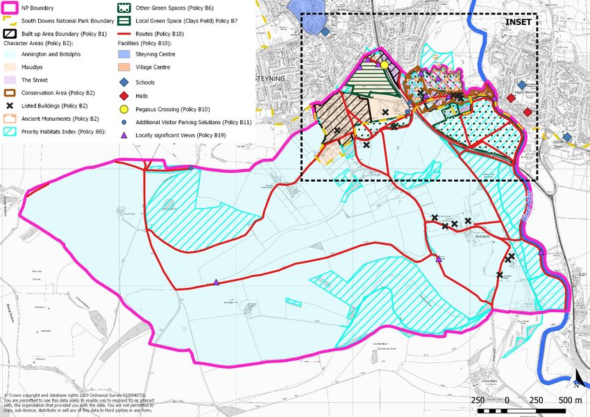
1          INTRODUCTION

1.1        This document presents the Bramber Neighbourhood Plan (‘the Plan’ or ‘the Neighbourhood
           Plan’). The parish sits across two local planning authority areas: the northern tip, including the
           village of Bramber itself, is within Horsham district, while the remainder lies within the South
           Downs National Park Authority (SDNPA).
1.2        The Bramber Neighbourhood Plan represents one part of the development plan for the parish
           over the period 2018 to 2031. The other parts are, the 2015 Horsham District Planning
           Framework, and, for the National Park area, the adopted Core Strategy and General
           Development Control Policies, 2007. Horsham District Council (HDC) is in the process of
           reviewing its Local Plan, with a view to consulting on it in August 2020. For the South Downs
           National Park Authority, The South Downs Local Plan1 was formally adopted by the South
           Downs National Park Authority on Tuesday 2 July 2019.
1.3        Horsham District Council (HDC) designated a Neighbourhood Area for the whole of the Bramber
           parish area on 15 February 2018 and the SDNPA designated the part of the parish within the
           National Park on 26 February 2018.
1.4        Figure 1.1 below shows the Bramber neighbourhood plan area, which shares its boundary with
           Bramber parish, indicating the part that lies within the National Park. This was designated by
           HDC and by the SDNPA in February 2018. HDC is the lead authority for the Neighbourhood Plan.

    1
        https://www.southdowns.gov.uk/wp-content/uploads/2019/07/SD_LocalPlan_2019_17Wb.pdf

                                                                                                                4
Figure 1.1: Bramber Neighbourhood Plan designated area
1.5   The Plan is being prepared in accordance with the Town & Country Planning Act 1990, the
      Planning & Compulsory Purchase Act 2004, the Localism Act 2011 and the Neighbourhood
      Development Planning Regulations 2012. The Neighbourhood Plan group has prepared the Plan
      to establish a vision and framework for the future of the parish and to set out how that vision
      will be realised through planning land use and development change over the plan period 2018
      to 2031.
1.6   The Plan will guide development within Bramber parish and provide guidance to any interested
      parties wishing to submit planning applications for development within the parish. The process
      of producing a plan has sought to involve the community as widely as possible and the different

                                                                                                    5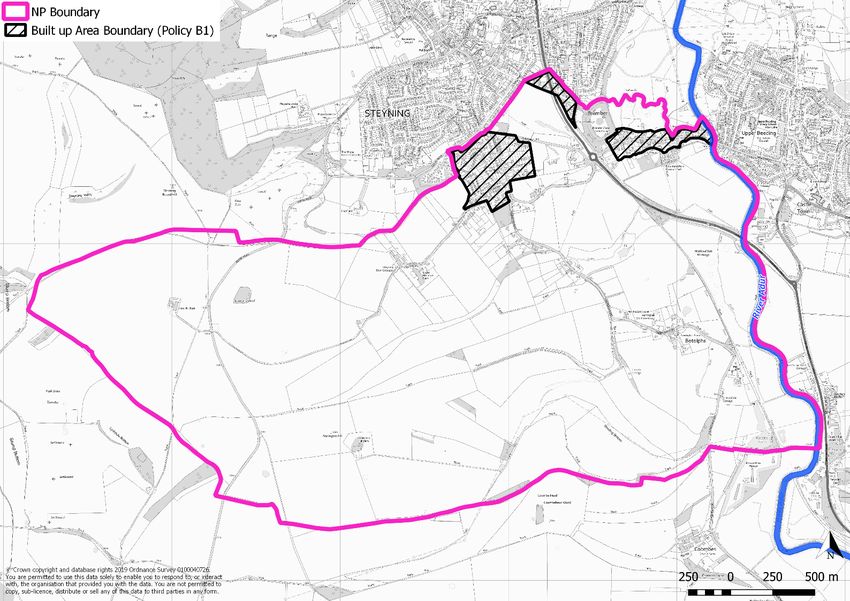
topic areas are reflective of matters that are of considerable importance. Each section of the
      plan covers a different topic. Under each heading there is a justification for the policies
      presented which provides the necessary understanding of the policy and what it is seeking to
      achieve. The policies themselves are presented in the blue boxes. It is these policies against
      which planning applications will be assessed. It is advisable that, in order to understand the full
      context for any individual policy, it is read in conjunction with the supporting text and evidence
      documents2 that have been compiled to underpin the Neighbourhood Plan.
1.7   In addition to the policies, the Plan identifies a number of local needs and community
      aspirations that are not met through the planning system but which are important to the well-
      being of the community. It is proposed that these projects will be met through community
      action supported by other organisations. The Plan also sets out the Community Infrastructure
      Priorities and a framework for monitoring and implementation.

      The Planning Policy Context
      National Planning Policy
1.8   The Neighbourhood Plan must have regard to the policies set out in the National Planning Policy
      Framework (NPPF).
1.9   The National Planning Policy Framework (NPPF) states at paragraphs 29 and 30:
              “Neighbourhood planning gives communities the power to develop a
              shared vision for their area. Neighbourhood plans can shape, direct and
              help to deliver sustainable development, by influencing local planning
              decisions as part of the statutory development plan. Neighbourhood plans
              should not promote less development than set out in the strategic policies
              for the area, or undermine those strategic policies3.

              Once a neighbourhood plan has been brought into force, the policies it
              contains take precedence over existing non-strategic policies in a local plan
              covering the neighbourhood area, where they are in conflict; unless they
              are superseded by strategic or non-strategic policies that are adopted
              subsequently.

1.10 This Pre-Submission Consultation draft (Regulation 14) Neighbourhood Plan is being prepared
     and submitted to Horsham District Council in accordance with the revised NPPF published in
     February 2019.

 2
  Available at: https://www.bramber.org.uk/neighbourhood-plan
 3
  Neighbourhood plans must be in general conformity with the strategic policies contained in any development
 plan that covers their area.

                                                                                                          6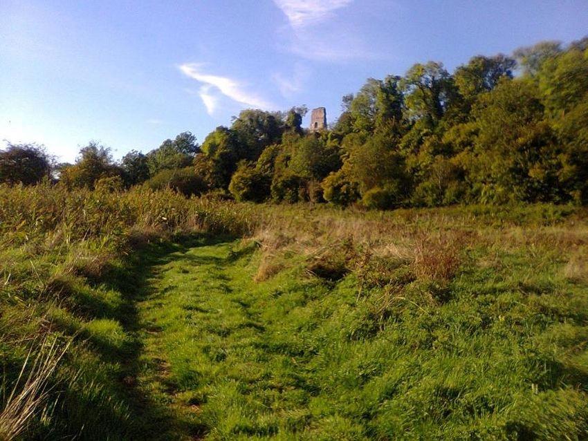
Local Planning Policy
1.11 The Local Plan for Horsham District consists of the Horsham District Planning Framework4 (HDPF),
     which guides decisions on planning applications and was adopted in November 2015. The HDPF
     covers the period 2011 to 2031 and provides the strategic framework for growth in Bramber
     (outside the South Downs National Park). The Bramber Neighbourhood Plan must be in general
     conformity with the strategic policies of the adopted HDPF.
1.12 Horsham District Council (HDC) has commenced a review of the HDPF, and whilst the timetable
     for this is not yet confirmed, HDC officers have advised that a draft of the updated HDPF will be
     consulted on in August 2020, with a view to adopting it in 2021.
1.13 For Bramber, therefore, the HDPF policies remain relevant to the area situated outside the
     National Park, to the north of the parish. This encompasses much of the village of Bramber. The
     HDPF is currently being reviewed with a view to adopting a new document in 2020.
1.14 For the South Downs National Park Authority, The South Downs Local Plan5 was formally adopted
     by the South Downs National Park Authority on Tuesday 2 July 2019. It sets out how development
     will be managed from 2014 to 2033. A summary of the key strategic policies of the HDPF and the
     strategic objectives of the South Downs Local Plan as they apply to the Neighbourhood
     Development Plan area are as follows:
 Horsham District: HDPF key policies
          Policy                                                 Commentary
 Policy 3 Development    This sets out that development will be directed to towns and villages that have defined
 Hierarchy               built-up areas and will be in-keeping with the context of the settlement type. Bramber is
                         classified collectively with Upper Beeding as a ‘small town/large village’. This
                         classification is for settlements with a good range of facilities and transport links as well
                         as acting as a hub for smaller villages.

                           Notably, many of the services mentioned are located within Upper Beeding as opposed
                           to Bramber, and this should be reflected in the way development is shaped in the future.
 Policy 4 Settlement       This sets out the criteria for the expansion of settlements, in particular where this is
 Expansion                 outside a defined settlement boundary. For Bramber, the village itself sits within a
                           defined settlement boundary and there is little remaining land beyond that, not within
                           the SDNPA.
 Policy 10 Rural           This encourages sustainable local employment growth through Neighbourhood
 Economic                  Development Planning and sets out the criteria required to support such enterprise.
 Development
 Policy 11 Tourism and     Encourages facilities that encourage visitors to the area.
 Cultural facilities
 Policy 15: Housing        Requires the provision of at least 1,500 homes throughout the district, in accordance with
 Provision                 Policy 3, allocated through Neighbourhood Development Planning ‘in accordance with
                           the settlement hierarchy’.
 Policy 16: Meeting        Includes support for schemes brought forward via Neighbourhood Development Plans.
 Local Housing Needs

 Policy 17 Exceptions      Allows for limited amounts of greenfield land development that would not otherwise be
 Housing Schemes           released for general market housing.

 4
   https://www.horsham.gov.uk/__data/assets/pdf_file/0006/28563/Horsham-District-Planning-Framework-
 2015.pdf
 5
   https://www.southdowns.gov.uk/wp-content/uploads/2019/07/SD_LocalPlan_2019_17Wb.pdf

                                                                                                                 7
Policy    25    Natural Protects, conserves and enhances landscape and townscape character of individual
 Environment        and settlements, maintaining settlement separation.
 Landscape Character
 Policy 40 Sustainable Supports development that enables sustainable transport options. This is important for
 Transport                Bramber as there is a high car dependency.
 South Downs Local Plan: Strategic Objectives
 Policy SD5 Design        Development proposals must adopt a landscape-led approach, respecting local
                          character.
 Policy SD20 Walking, The policy identifies the Downs Link, which crosses through Bramber, as being
 cycling and equestrian safeguarded for existing, and potential future use as a non-motorised travel route.
 routes
 Policy            SD25 Development will be directed primarily to the defined settlements, of which those in
 Development strategy     Bramber parish are not specifically listed.
 Policy SD26 Supply of Provision for approximately 4,750 net additional homes over a 19 year period between
 homes                    2014 and 2033. Neighbourhood Development Plans that accommodate higher levels of
                          housing than is set out above will be supported by the National Park Authority providing
                          that they meet local housing need and are in general conformity with the strategic
                          policies of the development plan. There is no housing requirement figure provided for
                          Bramber.
1.15 HDC is the lead local authority for the Bramber Neighbourhood Plan.

 Community engagement
1.16 The Bramber Neighbourhood Plan Steering Group (‘the Steering Group) has developed the Plan
     through extensive engagement with the community. Prior to Bramber developing its own
     Neighbourhood Plan, in the summer of 2014, the parish had commenced work on a
     Neighbourhood Plan in partnership with the neighbouring parishes of Steyning, Wiston and
     Ashurst. A Steering Group was formed in Sept/Oct 2014 comprising representatives from each of
     the parishes. Following this, six Focus Groups, involving over 70 volunteers, who were all local
     residents, were established to explore the various Plan themes. An extensive programme of
     engagement activities was undertaken, which ensured that the community had the opportunity
     to input into the emerging work at every stage. This included:

           • Hundreds of hours of volunteer time dedicated to giving local residents
             increased control over future local land use, including 25 meetings of the
             Steering Group and numerous focus group meetings (e.g. Housing – 16
             meetings).
           • Public survey issued in January 2015, and 844 responses received. Responses
             provided a basis for a broad understanding the range of opinions and
             suggestions at the outset of the project.
           • Vision statement produced January 2015.
           • Youth survey issued by Steyning Grammar School pupils in July 2015.Of nearly
             300 responses, 96 were received from young people in the SWAB parishes. This
             data was analysed & forwarded to the SWAB Team.
           • Call for sites issued in spring 2015 and Local Green Spaces survey.
           • A Stage One report produced in October 2015.

                                                                                                             8
• An informal public consultation exercise held over two weekends in January
2016 on the proposed sites and local open spaces. Over 700 residents attended.
• From Spring 2016 the key focus of the work was primarily to prepare the content
and policies for the ‘Pre-submission Document” (the draft NP)
1.17 In October 2017, the parish councils took the decision to move forward separately on individual
neighbourhood matters. Amongst other local matters, this was as a result of the changing
requirements and evolving legislation for neighbourhood planning, which resulted in the need
for each individual parish to review and re-evaluate its role within the parish cluster. After
careful consideration, Bramber took the decision to continue with a Neighbourhood Plan that
would cover just the area of Bramber Parish. They applied to designate the area and this was
formalised on 15 February 2018. A Steering Group was established comprising local councillors
and residents, and Focus Groups were set up to explore individual themes.
1.18 This has included:
Public exhibitions and drop-in events;
Face-to-face sessions with local voluntary and interest groups;
A questionnaire aimed at residents;
A questionnaire distributed to the businesses in the parish;
Leaflet drops to all houses in the parish;
Regular newsletter and press articles;
Presentations at key stages of the Plan; and
Presence at parish events.
1.19 Regular meetings and discussions with both HDC and the SDNPA have taken place on each of
the topics areas covered by the Plan. In addition, updates are provided through the minutes of
the Parish Council and Neighbourhood Plan Steering Group meetings. The Steering Group Chair
has also given verbal updates to the Chair of the Steyning NP Group.
1.20 A Consultation Statement will be attached to the final Submission Plan document.
Neighbourhood Plan Review
1.21 Notwithstanding the defined plan period to 2031, it is recognised that Neighbourhood Plans
should be reviewed periodically. The defining basis for Neighbourhood Plans is the Local Plan, in
this instance HDC’s HDPF and the South Downs Local Plan. The HDPF is in the process of being
reviewed and to ensure that emerging neighbourhood plans are in conformity with the local plan,
on 13 March 2019, following on from a ‘Future of Neighbourhood Planning’ seminar, HDC sent a
letter to all Parishes setting out options for developing their neighbourhood plans and in
particular how site allocations might be approached. Bramber, as a Parish with a Plan at an
advanced stage, considered that it would continue to develop its neighbourhood plan including
site assessments. Two potential sites have been explored as part of this process and both have
been assessed as unsuitable for development.
9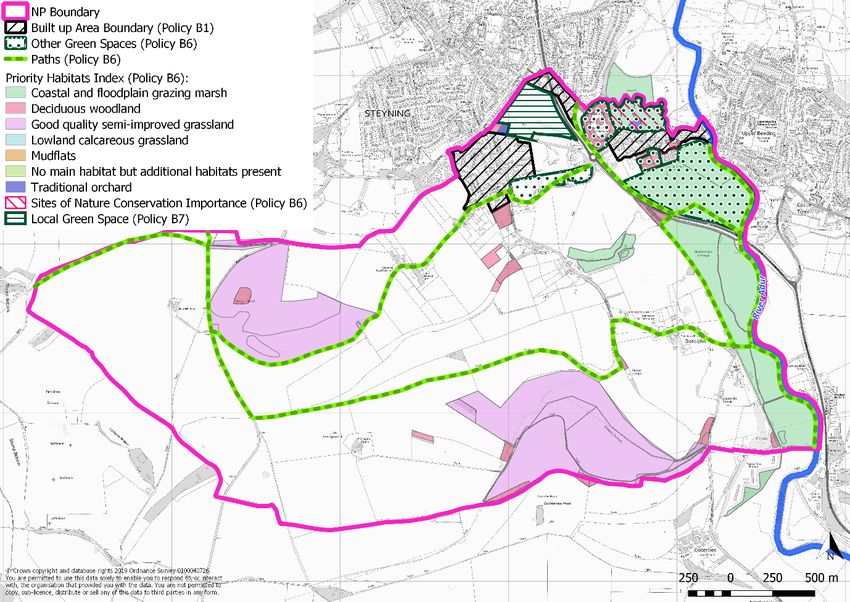
1.22 An early review of the Bramber Neighbourhood Plan will be required to take account of the
     changing strategic context with the expected adoption of the HDPF’s Local Plan in early 2021.

      Sustainability of the Neighbourhood Plan
1.23 The Neighbourhood Plan has been informed by an independent Sustainability Report, published
     in August 2019. This tested the potential impacts of the policies against a set of sustainability
     objectives developed in consultation with interested parties on the environment.
1.24 The purpose of the assessment is to avoid adverse environmental and socio-economic effects
     resulting from the Neighbourhood Plan, and identify opportunities to improve the environmental
     quality of the area covered by the Neighbourhood Plan and the quality of life of residents.
1.25 A key element of the process is the appraisal of ‘reasonable alternatives’ for the Neighbourhood
     Plan. In particular, this explored how the Plan’s development strategy has been shaped through
     considering alternative approaches for the location and quantum of housing in the
     Neighbourhood Plan area.
1.26 The assessment has concluded that the current version of the Neighbourhood Plan is unlikely to
     lead to significant negative impacts.

                                                                                                   10
2 ABOUT BRAMBER
2.1 Bramber is a rural parish of around 350 dwellings located to the south eastern settlement edge
of Steyning. Most of the parish is within the South Downs National Park and is therefore
relatively undeveloped. The core of the village comprises The Street and the Maudlyn area.
2.2 The Street is the historic centre with Bramber Castle which is maintained by English Heritage,
St. Nicholas Church (the oldest Norman church in Sussex) and St. Mary’s house as tourist
attractions, supported by the two hotels, restaurants and public car park in that area. The Castle
Lane area is separated from The Street by Bramber Castle, although they share this as a local
landmark and open green space, along with the south eastern edge of Steyning. St. Botolphs is
an Anglo Saxon church in Botolphs.
2.3 Maudlyn area has the largest number of residential properties within Bramber. The majority of
the properties are relatively modern and the area has the highest density of family units within
the village. This area directly abuts Steyning.
2.4 Annington and Botolphs which sit within the SDNP is essentially a mixed farming community
with a pig farm and stabling, but also includes a business park and a number of large private
houses. The southern part of the parish is very popular with walkers, equestrians and cyclists
with a number of footpaths and bridleways and access to the Downs Link, South Downs Way
and Monarch’s Way. Access for walkers and cyclists between the Downs Link and Steyning is
made via Castle Lane.
2.5 Although areas of Bramber have a close physical relationship to Steyning and Upper Beeding,
Bramber retains a strong and separate sense of identity. The parish councils do work closely
together and Bramber and Upper Beeding, for instance, share a village hall which is located in
Upper Beeding. Bramber has a strong volunteer group, which among other things monitors the
drainage ditches around Bramber working closely with the Environment Agency to alert them of
maintenance and potential flooding issues. As a parish Bramber positively encourages walking,
cycling and horse riding.
Profile of the community today
2.6 Detailed information on the profile is provided in the supporting evidence6. In summary, the key
aspects of the profile of the neighbourhood area, as they relate to the Plan, are as follows7:
Compared to the district as a whole, the parish has a significantly higher percentage of older
residents, aged 45 and over and in particular those aged 65+. This age bracket grew
considerably between 2001 and 2011.
There is a below average number of children and teenagers in the parish, when compared to
the district as a whole. The number of children dropped between 2001 and 2011, although
the number of teenagers and young adults grew, perhaps where children have been inclined
to stay at home rather than rent or buy their own homes.
6
Bramber Area Profile
7
Source: 2011 Census
11 The parish has higher than UK average levels of car ownership, with just 4% of residents
having no access to a vehicle. Higher car ownership is not unexpected in more rural areas,
however it will be important to ensure that public transport is adequate for those with limited
access and that people are encouraged to take shorter, local journeys by means other than
motor vehicle.
There is no railway in the parish, the nearest railway station is in Shoreham-by-Sea to the
south. There are five bus routes serving Bramber, connecting the village to the nearby large
villages and towns including Horsham, Worthing and Brighton.
Unemployment is very low with high numbers of people working from home (14%). The vast
majority of residents use their car to get to their workplace and distances travelled imply that
work is found in the neighbouring nearby larger towns, with some commuting to London.
The parish has seen limited housing growth over the last few decades. Houses are
predominantly owned, detached and more expensive than in the neighbouring towns. The
turnover of housing is low, suggesting little movement into the area. There are few
opportunities for rented properties, either social or private, when compared to the wider
area.
123 VISION AND OBJECTIVES
Challenges facing Parish
3.1 The Bramber Neighbourhood Plan seeks to address, as far as possible, the challenges that face
the community of Bramber parish. In summary these challenges are:
Meeting the demands of an ageing population in terms of providing homes that are suited to
their needs.
Providing homes in the parish that are financially accessible to younger people, especially
young families and those stepping onto the property ladder for the first time.
Safeguarding the rural, tranquil character, biodiversity and green spaces of the parish,
particularly given its position partially in the South Downs National Park.
Protecting the individual identify of Bramber, ensuring that encroachment on neighbouring
villages is minimised by maintaining the current inter-settlement gap.
Maintaining and protecting Bramber’s built heritage features and reflecting this character in
any future developments.
Supporting Bramber’s existing employment, retail and catering offer and, where possible,
helping to offer new opportunities.
Ensuring that tourism activity is sustainable and in keeping with the values of the national
park.
Seeking to improve accessibility to services in and near the parish – through the provision of
footpaths, cycle ways, bridleways and public transport - in order to help reduce over-reliance
on car use.
Vision for Parish
3.2 In consultation with the community, the vision for Bramber up to 2031 is:
The rural parish of Bramber will have retained its own recognisable character, with the quality of
the landscape spaces within and surrounding it continuing to define its identity.
Bramber’s role as a small village and place to visit will have evolved to continue to meet the needs
of local residents, but without compromising the special character that makes The Street so unique,
including the built heritage, the Conservation Area, listed buildings, and surrounding environs.
Community facilities (e.g. Bramber Castle, Bramber Brooks) will remain focal points for the
community and they will, where possible, be improved to become more attractive to both residents
and visitors alike; the parish council will have expanded its role in the management of such
facilities, along with their open spaces and natural assets.
The neighbourhood plan will have further enabled strong, positive and supportive working
relationships that exist with neighbouring parishes, local schools, the Steyning Health Centre and
local businesses. These will all continue to contribute to the vitality of the area, making a greater
13range of facilities available to the parish, and contributing to a shared sense of community pride in
Bramber.
Bramber will continue to support local employment and businesses. Its sustainable tourism offer
will have grown, making a positive contribution to the local economy and employment. This will be
supported by a plan developed in partnership with the South Downs National Park to protect the
shared rural setting of Bramber and make improvements to connectivity, green infrastructure and
heritage assets.
Accessibility to and connectivity between facilities, amenities, green space and recreational areas,
both within Bramber and with neighbouring settlements, will have been improved. This will include
maintaining and expanding, where necessary, the existing network of footpaths, bridleways, and
cycle routes, thus encouraging more people to find more sustainable ways to access local facilities
rather than using their cars, helping to cut down on congestion and pollution.
There will have been a modest growth in housing numbers across the parish through the provision
of new homes, designed to meet local needs including elderly downsizers and those starting out on
the housing ladder, including families. This will help to provide a balance of dwelling types to serve
the community over the long term, enabling those connected with Bramber to live here if they wish
while also encouraging new residents. New homes will have been provided in areas that do not
detract from the character and setting of the parish and will, where possible, encourage sustainable
living.
Neighbourhood Plan Objectives
3.3 The proposed objectives of the Bramber Neighbourhood Plan are as follows:
Objective 1: Protect the rural character of the parish, the qualities of its landscape setting
and its biodiversity, managing the impacts of any future growth.
Objective 2: Carefully manage the siting of development to protect the individual identity
and setting of Bramber.
Objective 3: Ensure that development is sustainable and sympathetic to the scale,
landscape setting, topography and architectural and historic character of where it is sited in
the parish.
Objective 4: Plan for some additional housing to meet predominantly local housing needs,
bearing in mind changing demographics, to provide a more balanced housing mix, in particular
for local affordability and elderly downsizers.
Objective 5: Address local transport issues, including car and parking issues, but
predominantly promoting sustainable transport options by improving connectivity to
facilities within and beyond the parish by integrating and, where possible, extending the
existing network of paths, separated where possible, to provide safe pedestrian, cycle and
horse riding routes. This includes safety of crossing points over the length of the A283 as it
cuts through the parish.
Objective 6: Promote opportunities for sustainable tourism, particularly where it enables
increased public accessibility to and enjoyment of the national park for recreation and leisure.
14Objective 7: Safeguard local green spaces that are valued by the community, improve
their biodiversity and integrate them with the footpath and bridleway network.
Objective 8: Support existing businesses operating in the parish and provide
opportunities for new ones where this can be achieved sustainably.
Objective 9: Retain and, where possible, expand the range of facilities and amenities
available for local residents.
154 SPATIAL STRATEGY
4.1 In a rural parish such as Bramber, it is particularly important that development is directed to
appropriate locations and that sprawl, and coalescence with surrounding settlements, is avoided.
The purpose of a built-up area boundary (BUAB) is to provide that direction. Policy B1, below,
defines the significance of the BUAB for Bramber.
4.2 For the Horsham part of the parish, the HDPF seeks to ensure that development takes place in a
manner that ensures that the settlement pattern and the rural landscape character of the district
is retained and enhanced, but still enables settlements to develop in order for them to continue
to grow and thrive. The mechanism by which this will be achieved is through the designation of
built-up area boundaries and the planned expansion of existing settlements through the Local
Plan or neighbourhood planning.
4.3 Bramber, together with neighbouring Upper Beeding, is classified within the ‘Small towns and
larger villages’ settlement type. This means they have a good range of services and facilities,
strong community networks and local employment provision, together with reasonable rail and/
or bus services. The settlements act as hubs for smaller villages to meet their daily needs, but
also have some reliance on larger settlements/ each other to meet some of their requirements.
4.4 Policy 14 of the HDPF states that at least 1,500 homes will be provided throughout the district in
accordance with the settlement hierarchy, allocated through Neighbourhood Planning. Bramber
village should consider a degree of growth in order to continue to prosper and meet local housing
need. However, this must be balanced against the need to preserve its character, its rural setting
as a gateway to the South Downs, the need to conserve its heritage assets and their settings and
to ensure that it does not coalesce with the neighbouring communities.
4.5 Policy 3 of the adopted HDPF provides guidelines for developments in relation to BUABs. It states
that: “Development will be permitted within towns and villages which have defined built-up areas.
Any infilling and redevelopment will be required to demonstrate that it is of an appropriate nature
and scale to maintain characteristics and function of the settlement in accordance with the
settlement hierarchy”.
4.6 Policy 4 of the adopted HDPF permits Neighbourhood Development Plans to make appropriate
changes to the Built-Up Area Boundary, including stating outside Built-Up Area Boundaries,
where the expansion of settlements will be supported where all of the following are met:
i. “The site is allocated in the Local Plan or in a Neighbourhood Development Plan and
adjoins an existing settlement edge;
ii. the level of expansion is appropriate to the scale and function of the settlement type;
iii. the development is demonstrated to meet the identified local housing needs and/or
employment needs or will assist the retention and enhancement of community facilities
and services.
iv. the impact of the development individually or cumulatively does not prejudice
comprehensive long term development, in order not to conflict with the development
strategy; and
16v. the development is contained within an existing defensible boundary and the landscape
and townscape character features are maintained and enhanced.”
4.7 For the South Downs part of the Parish, the South Downs Local Plan, in Policy SD26, makes
provision for The National Park Authority to provide approximately 4,750 net additional homes
over a 19 year period between 2014 and 2033. The part of Bramber that falls within the National
Park has not been allocated a level of housing to deliver. That said, the SDLP states that
“Neighbourhood Development Plans that accommodate higher levels of housing than is set out
above will be supported by the National Park Authority providing that they meet local housing
need and are in general conformity with the strategic policies of the development plan.”
4.8 Policy B1 of the Bramber Neighbourhood Plan reinforces the BUAB for the Bramber.
17Figure 4.1: Bramber’s Built Up Area Boundary
18POLICY B1: LOCATION OF DEVELOPMENT
1. Development in the neighbourhood area will be focused within the Built Up Area Boundary
as defined on the Policies Map.
2. Development proposals outside the Built Up Area Boundary will not be supported unless:
a. it is in accordance with Horsham District Planning Framework policies or the policies of
the South Downs Local Plan, in respect of appropriate uses in the countryside; or the
development preserves or enhances the character or appearance of the area; or
b. the development brings redundant or vacant historic buildings back into beneficial use
in a manner that does not cause harm in terms of additional traffic; or
c. it relates to necessary utilities infrastructure and where no reasonable alternative
location is available.
d. it is on sites allocated for those uses in the Horsham District Planning Framework, South
Downs Local Plan or their successors.
3. Proposals should make the best use of suitable brownfield land, where available, before
greenfield land is released for development.
Conformity Reference: NDP Objective 1, 2, 4; 2015 HDPF 3, 4; SDLP: SD1; NPPF: 20, 72
195 HOUSING
Housing requirement
5.1. The 2011 Census confirms that in 2011 Bramber parish had 348 households, the majority
contained within the village of Bramber itself. There was a high level of home ownership (87.6%)
and very low proportions of social rented (0.6%) and private rented (11%) tenures.
There was a predominance of family sized housing with 64% of homes detached, 20% semi-
detached and terraced, with 7% flats.
5.2. The parish is split across two local authority areas; the village of Bramber falls within Horsham
District and is therefore subject to its planning policy. Beyond this, the remainder (geographically)
of the parish, including the rural settlements of Botolphs and Annington, lies within the South
Downs National Park.
5.3. The Horsham District Planning Framework makes provision for the development of at least
16,000 homes and associated infrastructure within the period 2011-2031. Policy 15 of the
Horsham District Planning Framework states that this will be delivered through a series of
sources:
Housing completions for the period 2011 – 2015;
Homes that are already permitted or agreed for release;
Strategic sites;
The provision of at least 1500 homes throughout the district in accordance
with the settlement hierarchy, allocated through Neighbourhood Planning;
and
750 windfall units
5.4. Whilst there is no specific housing target provided for Bramber parish, there is an expectation
that housing will be allocated through Neighbourhood Plans to contribute towards both the local
housing need and strategic housing need.
5.5. The South Downs Local Plan makes overall provision for approximately 4,750 net additional
homes over a 19 year period between 2014 and 2033. No specific housing number is attributed
to the part of Bramber parish lying within the national park, however neighbourhood plans that
accommodate higher levels of housing than is set out in the SDNPA Local Plan will be supported
by the National Park Authority providing that they meet local housing need and are in general
conformity with the strategic policies of the development plan.
5.6. In order to consider the number of new homes that might be appropriate for Bramber, an
independent Housing Needs Assessment8, undertaken by AECOM, was published in August 2018.
The report attributed to Bramber (parish-wide) a gross, unconstrained figure of 64 dwellings to
be delivered across the lifespan of the plan. Eight dwellings have already been delivered, leaving
56 dwellings to be delivered until 2031, which equates to approximately four dwellings per year.
8
Housing Needs Assessment, AECOM, August 2018
205.7. As part of the Neighbourhood Plan process, a local Call for Sites was issued during June and July
2018, seeking sites no smaller than 0.25 hectares. Two sites were put forward, one located in
Horsham district and the other in the South Downs National Park. In consultation with HDC and
the SDNPA, the Steering Group developed a set of criteria to assess the ability of the submitted
sites to address the objectives of the Neighbourhood Plan in a sustainable manner.
5.8. The site assessments, included at Appendix A, concluded that neither site was considered suitable
for development. The Bramber Housing Report incorporating site assessments9, contains fuller
detail on the process.
5.9. The Neighbourhood Plan does not, therefore, seek to allocate sites for development. That is not
to say that suitable sites may not become available in the future. An early review of the
Neighbourhood Plan, therefore, will be undertaken to take into account the policies of the revised
HDPF and the implications of these. This will provide greater clarity about the amount of growth
that Bramber may be expected to accommodate over the new HDPF plan period.
AIM 1: Prepare for early review of Neighbourhood Plan
An early review of the Neighbourhood Plan will be undertaken once the review of the Horsham
District Planning Framework 2015 has established a new spatial strategy for the district. This will
take into account the implications of the new policies of that plan. Should new sites emerge as
part of the HDC Review, these will be assessed by HDC to determine if they are suitable for delivery
and allocated as part of that Review.
9
Housing Report and site assessments available at https://www.bramber.org.uk/neighbourhood-plan
216 DESIGN AND HERITAGE
Character of development
6.1. Past generations of people and development have created the features that give the parish its
distinctive identity today. Bramber is home to heritage assets of all kinds, including characterful
buildings, historic landmarks and archaeological features, including Bramber Castle and St Mary’s
House and Gardens. The rural setting, being situated largely in the South Downs National Park, is
significant and it will be important for development to be of a high quality, sustainable and in-
keeping with the particular context of where it is sited.
6.2. In addition to the Bramber Conservation Area Design and Advice leaflet10, three ‘character areas’
have been identified in the parish and are shown in Figure 6.1. A summary of each is provided
below and fuller descriptions are provided in the AECOM Design Codes Report11, developed to
inform the Neighbourhood Plan and published in July 2019.
10
https://www.horsham.gov.uk/__data/assets/pdf_file/0006/5829/BramberConAreaAppraisal.pdf
11
https://www.bramber.org.uk/neighbourhood-plan - document available on website
22Figure 6.1: Character areas in Bramber
23Character Area Photograph
The Street
The Street is the historic core of Bramber
with focal points being Bramber Castle,
maintained by English Heritage, the Norman
Church and the medieval St. Mary’s house.
Although there is a mix of housing styles
from different periods in time they have
been designed, in the main, in such a way
that the historic importance of this area and
its associated houses have not been
compromised. This aspect should be taken
into account in any new or re-development
proposals.
Maudlyn
A residential neighbourhood to the west of
the A283, this area of Bramber has the
largest number of houses in the Parish
which, in the main, comprise detached
houses and bungalows built during the final
quarter of the last century. Any proposals
for development/re-development in this
area should complement the designs of this
existing housing stock.
Annington and Botolphs
Annington and Botolphs which sit within the
SDNP is essentially a farming community
with a pig farm and stabling, but also
includes a business park and a number of
large private houses. This area of Bramber is
important to the SDNP in relation to the
landscape, farming and tourism and new
housing development will be restricted as a
consequence.
6.3. The built character across each area ranges in style, age, size and housing densities. For each
area to maintain its character, a balance needs to be struck between the scale, bulk, density and
height of the built form and that of open green spaces and, where relevant, the countryside.
6.4. All development should be designed to a high quality and reinforce and enhance local character,
heritage assets and the rural setting of the area. The density of development should create a
character that is appropriate to the site’s context, including the landscape in which it is set, whilst
making best use of the land available. Lower density housing should be located towards the outer
edges of the settlement where it abuts open countryside, to maintain views from and into the
individual settlements.
6.5. Development should have regard to both the character of the area in which it is set and to the
character of the area overall.
24POLICY B2: CHARACTER OF DEVELOPMENT
1. Development is expected to preserve and enhance the character area in which it is located
(as shown in Figure 6.1). The design of new development should demonstrate how it has
taken account of the local context and has reflected the character and vernacular of the
area, using architectural variety in form and materials, in order to avoid building design that
is inappropriate to the Plan area. Innovation in design will be supported where this
demonstrably enhances the quality of the built form in a character area.
2. In particular, development proposals are expected to address the following criteria:
a. Make a positive contribution to the visual impact of the main highway approaches into
the settlements.
b. Not have a significantly detrimental impact on the local views as set out in Policy B9.
c. Development proposals directly affecting heritage assets – including non-designated
heritage assets - should respect the significance and context of the asset and
demonstrate how they will contribute to the conservation and enhancement of the
heritage asset.
3. Where development sites abut open countryside, development on the rural boundary edge
is expected to mitigate any visual impacts on the countryside. This could either be through
the siting of lower density development at the rural boundary of the site in order to provide
a gradual transition from the built form to open countryside, or it could be through a layout
that clearly minimises the visual impact of any larger buildings.
Conformity Reference: NDP Objective 1, 2, 3; 2015 HDPF 32, 33, 34, 42; SDLP: SD5, SD6, SD12, SD13;
NPPF: 125, 127
Design of development
6.6. Good quality housing design can improve social wellbeing and the quality of life by improving the
built environment, reducing crime, improving public health, easing transport problems and
providing supportive neighbourhoods.
6.7. The Building for Life 12 (BfL12) January 2015 third edition6 is the Government-endorsed industry
standard for the design of new housing developments. Building for Life is a tool for assessing the
design quality of homes and neighbourhoods. The criteria also link to other standards for housing
design, including the Housing Quality Indicators (HQI) standards, Secured by Design and Lifetime
Homes. The BfL12 provides a framework that stakeholders should use for development along
with other policies contained within this plan for the neighbourhood area to achieve the industry
standard’s ‘Built for Life’ quality mark.
6.8. The eastern part of the parish is situated in Flood Zone 3 where the river corridor runs through.
There have been instances of flooding in the village centre, for instance in 2000, the banks of the
River Adur overflowed north of Bramber, reaching The Street, as a result of high tides and
unusually high rainfall. On the whole, however, flood incidents have tended to be caused by
equipment failures; volunteers from Bramber now regularly check the ditches and pumps around
Bramber and work closely with the Environment Agency to help avert any further instances. A
25Contingency Plan, including a Flood Plan, has now been developed, and emergency kit is now
stored in the village.
6.9. Fundamentally flooding issues are for the Environment Agency and the Local Lead Flood
Authority to address, however new development should be designed to ensure that surface
water drainage does not add to the existing site run off or cause any adverse impact to
neighbouring properties or the surrounding environment/wildlife habitat. It is the responsibility
of a developer to make proper provision for surface water drainage to ground, water courses or
surface water sewer. It must not be allowed to drain to the foul sewer, as this is the major
contributor to sewer flooding.
6.10. The Bramber Neighbourhood Plan Design Guidelines, produced by AECOM12, includes general
design guidelines for the whole area as well as guidelines that are specific to the character areas
and local character areas. Applicants should work closely with those affected by their proposals
to evolve designs that take account of the views of the community.
6.11. When these building standards and guides are updated or superseded, this Neighbourhood Plan
should use the updated standards for good quality, well-designed homes and neighbourhoods.
Policy B3: Design of Development
Development is expected to demonstrate a high quality of design, which responds and
integrates well with its surroundings, meets the changing needs of residents and minimises the
impact on the natural environment. Development proposals will be expected to demonstrate
how they have sought to address the following matters:
a. Being guided by the principles of Building for Life unless alternative principles would
otherwise result in a higher quality of design. Development proposals are encouraged to
achieve the ‘Built for Life’ quality mark.
b. The guidance contained within the Bramber Neighbourhood Plan Design Guidelines13.
c. The creation of variety through the use of a range of housing designs, provided that the
predominant type of design reflects the character of the area.
d. Dwellings designed to be suitable for older residents (aged 60 and over) are encouraged to
meet the space and accessibility requirements of the Lifetime Homes standards. Such
dwellings may also be suitable for younger residents and are not intended to be restricted
to particular users.
e. To design layouts of safe and secure dwellings that meet the requirements of ‘Secure by
Design’ and minimise the likelihood and fear of crime.
f. Provide off-road parking for residents, visitors and service vehicles, in accordance with the
West Sussex Residential Parking Guidance14 and in accordance with Policy B12
(Encouraging sustainable movement).
12
https://www.bramber.org.uk/neighbourhood-plan - document available on website
13
Ibid.
14
https://www.westsussex.gov.uk/media/1847/guidance_parking_res_dev.pdf
26g. To ensure that areas requiring service and maintenance including watercourses are
accessible at all times.
h. Development that is required to provide Sustainable Drainage Systems (SuDS) is expected
to provide this on-site, unless there are clear reasons why this is not possible. Such
development is encouraged to demonstrate the use of a wide range of creative SuDS
solutions, for example through the provision of SuDS as part of green spaces, green roofs,
permeable surfaces and rain gardens. SuDS provision must demonstrate how its design will
enhance wildlife and biodiversity as well as minimise the impacts of flooding. Only where
it is demonstrably unviable will an absence of any on-site SuDS provision be permissible in
such developments.
i. Traffic generation and parking does not adversely affect vehicular and pedestrian safety.
Conformity Reference: NDP Objective 1, 2, 4; HDPF Policy 32, 33, 42; SDLP Policy SD5 and NPPF: 124,
125, 126, 127, 149
Energy efficiency and design
6.12. On 12 June 2019 the Government voted to amend the Climate Change Act 2008 by introducing a
new target for at least a 100% reduction of greenhouse gas emissions (compared to 1990 levels)
in the UK by 2050. This is otherwise known as a net zero target. This is a demanding target, which
will require everyone to be engaged, from households and communities, to businesses and local
and national government.
6.13. Being ‘2050 ready’ will require new build to have minimal energy use and net carbon emissions
over the year. They should be highly insulated, have low water demand and be fitted with or
directly connected to renewable energy systems.
6.14. Nearly Zero-Energy requirements for new developments will come into force in 2019; in the
meantime, standards for ecologically sustainable homes and developments are optional,
however, planners and developers are strongly encouraged to make use of energy efficient
materials and to consider high-efficiency alternative systems and facilities for development sites.
In this context, the orientation of buildings can be important in order to make best use of
available sunlight.
6.15. The Code for Sustainable Homes was withdrawn by the Government in 2015 and this has been
replaced by new national technical standards which include new additional optional Building
Regulations regarding water and access as well as a new national space standard (this is in
addition to the existing mandatory Building Regulations).
6.16. There is an opportunity to improve and promote sustainability in Bramber by:
following basic passive environmental design in a fabric first approach;
integrating renewable energy systems into new development, including existing and new
public buildings;
27 reducing water consumption through grey water systems;
promoting sustainable forms of transport through priority systems for pedestrians and
cyclists;
community energy schemes; and
promoting public transport.
6.17. This Neighbourhood Plan seeks to encourage energy efficient and sustainable well-designed
development.
POLICY B4: ENERGY EFFICIENCY AND DESIGN
1. The design and standard of any development is encouraged to achieve the
highest level of sustainable design, in order to reduce energy consumption and
climate effects. This includes:
a. Siting and orientation to optimise passive solar gain, either through the provision of
solar photovoltaic cells as part of development or by ensuring that development is
designed to maximise the potential for solar gain if retrofitted at a later date.
Efforts should be taken to integrate such equipment neatly into the design of the
building.
b. The use of high quality, thermally efficient building materials, particularly those
that are used to achieve the Passivhaus or equivalent standard.
c. Installation of energy efficiency measures such as loft and wall insulation and
double glazing.
d. Incorporating on-site energy generation from renewable sources such as solar
panels.
e. Reducing water consumption through the use of grey water systems.
f. Providing low carbon sustainable design and avoid or mitigate all regulated
emissions using a combination of on-site energy efficiency measures (such as
insulation and low energy heating systems), on-site zero carbon technologies (such
as solar panels) and only where necessary off-site measures to deal with any
remaining emissions.
g. Providing the infrastructure for adequate electric vehicle charging points for each
dwelling, where new parking provision is expected to be made.
h. Alterations to existing buildings should be designed with energy reduction in mind
and comply with current sustainable design and construction standards.
2. The retrofitting of heritage properties/assets is encouraged to reduce energy demand and
to generate renewable energy where appropriate, providing it safeguards historic
characteristics and development is done with engagement and permissions of relevant
organisations.
Conformity Reference: NDP Objective 3; 2015 HDPF: 36, 37; SDLP: SD14, SD48, SD51, SD54; and
NPPF 149, 150, 154
287 ENVIRONMENT AND COUNTRYSIDE
Protecting flora and fauna
7.1 The NPPF stresses that planning policies and decisions should contribute to and enhance the
natural and local environment including providing net gains for biodiversity.
7.2 Protected natural assets in the Neighbourhood area include the following:
a. the South Downs National Park – covering the parish to the south of Bramber
village
b. Green spaces that contribute to the character definition and local amenity,
including St Mary’s Field, Bramber Brooks, and Clays Field
c. Local historic assets and their settings, including Bramber Castle
7.3 The distinctive features of the area that are not protected, yet provide vital habitats for flora and
fauna, include trees, woodland, hedgerows, and mature, planted gardens. Hedgerows are a major
part of the wildlife corridors that stretch across the parish of Bramber. Together with the
extensive network of ditches that criss-cross the Adur valley floodplain, hedgerows form a vital
corridor for a large number of animals and birds, especially those migrating, to safely navigate
around their domains. In addition, the varied hedgerow species provide both food and shelter
for the small mammals, amphibians, insects and birds that make their homes in this area. Break
up of this continuous network would lead to isolation and decline. With the provision of the
proposed additional ponds in the Bramber Brooks Nature Reserve the number of migrating water
birds is expected to increase and the provision of adequate local hedgerows will be even more
important.
7.4 Information from the Sussex Biodiversity Record Centre shows sightings of over 50 distinct
Biodiversity Action Plan species since 2006. This includes species such as Corn Bunting, Linnet,
Yellowhammer, Skylark, Song Thrush, Marsh Tit and Lapwing. These habitats and species have
evolved in response to local geology and land use, may have taken hundreds of years to establish
and cannot be replaced in any meaningful way.
7.5 Developments should therefore seek to protect and enhance these habitats where possible and
include an appropriate landscape and ecological management plan including a list of trees and
shrubs to be planted to ensure the rural and green character of the parish is enhanced and which
should involve the planting of new trees and hedgerows of native species in gardens, communal
areas or on roadsides where practical.
POLICY B5: PROTECTING FLORA AND FAUNA
1. Development proposals should contribute to achieving net gain in biodiversity. They should
maintain and enhance the natural environment, retain landscape features, such as
hedgerows, woodland and gardens, and enhance the rural character and setting of the
Neighbourhood area. Where reasonable and necessary, development proposals are
expected to demonstrate that they have addressed the following matters:
Trees and woodland:
a. There is no unacceptable loss of, or damage to, existing trees or woodlands during or as
29You can also read