Great Barford Neighbourhood Plan Draft - November 2020
←
→
Page content transcription
If your browser does not render page correctly, please read the page content below
Great Barford Neighbourhood Plan
              Draft

            November 2020
This page left blank
Contents
   Foreword............................................................................................................................................. 3
1.       Introduction ................................................................................................................................ 5
   Parish Map .......................................................................................................................................... 6
2.       The Strategic Policy Context ....................................................................................................... 7
   The National Planning Policy Framework ........................................................................................... 7
   Sustainable Development ................................................................................................................... 7
   Local Planning Documents .................................................................................................................. 7
3.       Parish Description ....................................................................................................................... 8
   History and Growth of the Village....................................................................................................... 8
   Landscape ........................................................................................................................................... 9
   Green Infrastructure (GI) .................................................................................................................... 9
   Education .......................................................................................................................................... 10
   Recreation Facilities .......................................................................................................................... 10
   Local Business, Services and Employment ........................................................................................ 10
   Population & Household Data .......................................................................................................... 10
4.       Consultation .............................................................................................................................. 10
5.       Vision and Objectives ................................................................................................................ 12
6.       Sustainable Development ......................................................................................................... 14
   Introduction ...................................................................................................................................... 14
7.       Design of New Development .................................................................................................... 15
   High Quality Design and Rural Character.......................................................................................... 15
   Sustainable Design and Construction ............................................................................................... 17
8.       Housing ..................................................................................................................................... 18
   New Housing ..................................................................................................................................... 18
   Affordable Housing ........................................................................................................................... 19
   Market Housing Mix.......................................................................................................................... 19
9.       The Natural Environment.......................................................................................................... 22
   Landscape ......................................................................................................................................... 22
   Nature Conservation ......................................................................................................................... 24
10.      Recreation and Open Space ...................................................................................................... 26
   Local Green Spaces ........................................................................................................................... 28
11.      Conservation ............................................................................................................................. 30
   Conservation Area............................................................................................................................. 30
   Built Heritage Assets ......................................................................................................................... 31
   Archaeology ...................................................................................................................................... 32
12.      Traffic and transport ................................................................................................................. 33
   A428 - Black Cat Roundabout to Caxton Gibbet ............................................................................... 33
   A1 - Future Developments ................................................................................................................ 34
   Other Issues ...................................................................................................................................... 34
   Buses ................................................................................................................................................. 34
   Sustainable Modes of Transport ....................................................................................................... 35
   Active Travel and Accessibility .......................................................................................................... 36
   Rights of Way .................................................................................................................................... 37

                                                                             [1]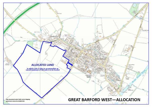
13.    Community Facilities ................................................................................................................. 38
14.    Local Employment & Business .................................................................................................. 40
  Local Businesses ................................................................................................................................ 40
15.    Aspirations for Great Barford ................................................................................................... 42
  Green Infrastructure Plan Aspirations .............................................................................................. 42
  Parish Plan 2010-2015 Proposals ...................................................................................................... 43
16.    Implementation and Monitoring .............................................................................................. 45
  Working in Partnership ..................................................................................................................... 45
  Funding and Implementation Mechanisms ...................................................................................... 45
Annex 1: Policies Maps........................................................................................................................ 47
  Policy Map 1: Map of Development Allocation Land West of Great Barford ................................... 47
  Policy Map 2: Local Green Spaces ..................................................................................................... 48
  Policy Map 3: Key Views ................................................................................................................... 49
  Policy Map 4: Rights of Way – from BBC Definitive Map.................................................................. 50
Annex 2: Relationship Between Objectives and Policies .................................................................... 51
Annex 3: Glossary ................................................................................................................................ 52

                                                                         [2]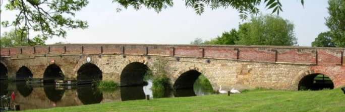
Foreword
With changes in Central Government planning legislation, the Localism Act 2011 introduced to the
Town and Country Planning Act 1990, the idea of local communities being able to shape
development and land use in their locality. The Neighbourhood Planning (General) Regulations 2012
came into force on 06 April 2012.

Around this time, Bedford Borough Council was already reviewing local planning policies to bolster
the existing Local Plan 2002. Bedford’s Development Plan was made up of a series of Local
Development Documents. The overall strategy for the borough was set out in the Core Strategy and
Rural Issues Plan 2008, and the Bedford Town Centre Area Action Plan 2008. The adoption of these
led to the deletion of some saved Local Plan policies, and were supplemented by the later adoption
of the Allocations and Designations Local Plan in 2013. Together, these would shape the borough’s
development requirements up to 2021.

The recent changes to the planning system meant that Bedford Borough must consider future local
need and identify its own targets for growth and development. This manifested itself in the
production of a new Local Plan for Bedford Borough that will set out how much growth there should
be, and where it should take place. That work has culminated in the emergence, and adoption on 15
January 2020, of the Bedford Local Plan 2030, to identify and define development growth for the
next ten years.

It was during the early stages of evolving the Local Plan that the Borough started consulting on
various spatial growth strategies. It soon became apparent that growth was not going to be
contained within the previous developments concentrated towards the south and west of Bedford;
there was a desire to branch out into the rural parts in the northern part of the borough. This
strategy started to put focus on the Rural Key Service Centres, to include Great Barford, in delivering
some of the required growth.

Stories from around the rest of the country started painting a picture of the rural idyll coming under
fire, with development growth taking place without regard for the community’s view of where it
should be located. Other regional communities were taking advantage of legislation to provide
planning policies for their local area.

In 2014, Great Barford Parish Council became aware that there would be a benefit to become
actively involved in what was seen to be happening. There was a desire to have a say in determining
our own future, and in a way that would also support development in the Borough. At the Parish
Council meeting of 18 November 2014, it was resolved to prepare a Neighbourhood Plan for the
Parish. A new Sub-Committee was established to administer the process; a Chairman was proposed,
and two other Councillors volunteered to establish the new Neighbourhood Plan Committee.

The decision was publicised in our Parish Magazine, the Barford Bugle, and we started a recruitment
drive to elicit the help from parishioners, both Residents and Councillors. By May of 2015 we had
sufficient support to call our first Neighbourhood Plan Committee meeting. Although some members

                                                  [3]
have come and gone as time moved on, we have always managed to maintain a really good balance
of broad skills, knowledge and experience. Key members have many years experience in Local
Planning, Architecture, Accountancy, Project Management and other supplementary expertise.

As we have found, enthusiasm counts for a lot, and where specific knowledge may have been
wanting, there has always been copious information available from the likes of Locality. This
organisation is a national membership network, supporting local communities; they are the go-to
people for all things about Neighbourhood Planning. But we would not have got where we are today
without the specialist knowledge and meticulous steering from our Neighbourhood Plan Consultant,
Sally Chapman.

This Neighbourhood Plan for Great Barford has been created by Residents and Councillors for the
benefit of the parish. It has identified local issues, developed a vision and objectives to prepare
policies that will support planning, development and sustainability throughout the parish. When
made, it becomes part of the technical evidence base in support of delivery of the Bedford Local
Plan. The Great Barford Neighbourhood Plan provides guidance, policies and allocates development
site opportunities, to meet the requirements set out in the Local Plan. It bestows control to the local
community, to define and manage the future of our parish.

Graham Pendrey
Chair
Neighbourhood Plan
Great Barford Parish Council

The Neighbourhood Plan Team
         Di Ames     Councillor
       Neil Ayers    Resident
     Keith Blaxill   Resident
   Noreen Byrne      Councillor
    Jon Digweed      Resident
   Duncan Edgar      Councillor
  David Garrard      Councillor
     Barry Harris    Resident
      Simon Holt     Resident
       Cliff Mace    Resident
Graham Pendrey       Councillor
   Anne Sammé        Resident
Siobhan Vincent      Resident
       Tim Wood      Councillor
                                     Map reproduced under Public Sector Mapping Agreement
                                     Licence No 0100053584

   Sally Chapman Consultant

                                                                                            [4]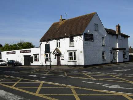
1. Introduction
1.1. In 2011, the Localism Act introduced a new opportunity for local communities to shape
their future formally as part of the planning system. Neighbourhood Plans can be
produced by Parish Councils and when they have gone through all the required steps
and processes, they become part of the development plan for the area. This means that
any planning applications will have to take account of policies contained within the
Neighbourhood Plan. It also provides local people with a say on how land use and
buildings can develop over time, such as protecting open spaces and improving local
character.
1.2. Producing a Neighbourhood Plan is a formal process involving several stages, governed
by the Neighbourhood Planning Regulations 2012, but critically important is that the
Plan is developed with continuing community involvement. In order to rigorously test
the policies of a Neighbourhood Plan, an independent Examination is carried out. The
Neighbourhood Plan must conform to the following ‘basic conditions’:
consistency with local planning policy;
demonstrates how the plan will contribute towards sustainable development;
regard to national policy;
general conformity with strategic local policy;
contributing to the achievement of sustainable development;
compatibility with EU obligations; and
meet prescribed conditions and comply with prescribed matters.
1.3. Once the Plan has passed Examination, it is voted upon in a referendum by Parish
residents and if a simple majority ‘yes’ vote is achieved, then the Neighbourhood Plan is
‘made’ by Bedford Borough Council and comes into force as a planning document with
legal weight in decision-making.
1.4. Great Barford Parish Council decided on 18 November 2014 to prepare a
Neighbourhood Plan for the Parish, to enable the local community to have a say in
determining their own future, and in a way that would also support development planning
in the Borough.
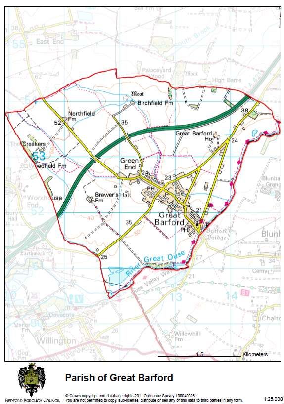
1.5. On 23 April 2015, BBC designated the area within the Great Barford Parish Boundary, as
a Neighbourhood Area as shown on the map.
[5]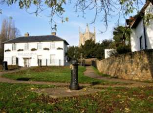
Parish Map

             [6]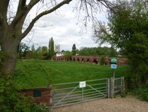
2. The Strategic Policy Context
The National Planning Policy Framework
    2.1.   The National Planning Policy Framework (NPPF) 2019 version was published in February
           2019 and sets out the Government’s approach to sustainable development. At the heart
           of the NPPF is the ‘presumption in favour of sustainable development’. Essentially, it is
           about positive growth with economic, social and environmental gains being sought
           simultaneously through the planning system. Neighbourhood Planning forms part of the
           NPPF approach to planning, to allow local communities to shape sustainable
           development within their area and to enable local communities to address their
           strategic needs and priorities. The NPPF states that Neighbourhood Plans should set out
           a positive vision for the future of the local area with planning policies to determine
           decisions on planning applications, including policies which set out the quality of
           development that should be expected for the area, based on stated objectives for the
           area’s future and an understanding and evaluation of its defining characteristics.
           However, a Neighbourhood Plan must be in general conformity with the strategic
           policies of the Local Plan and plan positively to support these policies.

Sustainable Development
    2.2.   The Neighbourhood Plan must contribute to the achievement of sustainable
           development. The NPPF states that pursuing sustainable development includes making
           it easier to create jobs in villages, to promote gains in biodiversity, to achieve better
           quality design, to improve people’s quality of life, and to provide a wider choice of high
           quality homes.
    2.3.   Therefore, the aims objectives, policies and proposals of the Neighbourhood Plan
           should be assessed against their ability to achieve sustainable development. Wherever
           possible the Neighbourhood Plan should actively promote the achievement of
           sustainable development.

Local Planning Documents
    2.4.   The Local Plan currently consists of the Bedford Borough Local Plan 2030 which was
           adopted on the 15th January 2020. There are also some remaining relevant policies in
           the Allocations and Designations Local Plan 2013 and these are referenced in the Local
           Plan 2030. The Borough also has a suite of Supplementary Planning Documents which
           provide more detailed information and application of policies. The current list is
           available on the Borough Councils website.

                                                 [7]
3. Parish Description
3.1. Great Barford is a village which historically owes its location to the Ouse River crossing
and its proximity to the “Great North Road”. The village is approximately 5 miles
northeast of Bedford and 7 miles southwest of St Neots. It has good links to Milton
Keynes (22 miles), Cambridge (25 miles), Peterborough (35 miles) and London (62
miles).
3.2. The centre of the village is the crossroads between the Bedford Road and Roxton Road
(northeast southwest) C44 (formerly A428) and the High Street and Green End Road
(northwest southeast). New Road links Great Barford Bridge towards the A1 Black Cat
roundabout.
3.3. The A421 has bypassed the village since 2006. The A421 dual carriageway, which will
form part of the Oxford to Cambridge Expressway, links the village towards the A1, M1
and M11 for connections to the major centres of London, Milton Keynes and
Peterborough.
History and Growth of the Village
3.4. Great Barford has been inhabited since well before Roman times. This is evident in crop
marks, which are seen by a variation in the growth of crops, visible from the air during
certain times of the year.
3.5. One meadow situated along the High Street shows traces of an old medieval ridge and
furrow field, probably the only one to be found within the village confines. This land
was cultivated in the two-field system, one year for crop and the next for fallow. The
field would have been a furrow long (furlong).
3.6. There is a mention of Great Barford in the Doomsday Book. Local administration was
divided into 'Hundreds', and 'The Hundred of Bereforde' was one of nine in
Bedefordscire. Its importance was probably due to its river crossing. Each 'Hundred' had
a court which met in the open air. The Barford Court was probably marked by a cross,
the base of which still exists, although at some unknown point it was moved to its
present position on the corner of Silver Street and the High Street.
3.7. There appears to have been a bridge crossing since the 15th Century, when in 1427,
£100 was left in the will of Sir Gerald Brayrooke “to replace a ford”, the Barford Bridge
was built. There is mention of an eight arch bridge in the 15th Century, with another
arch being added in 1753. The bridge was widened in 1818 and finally, in 1874 a brick
face was built out on the south east side to give the present width. There is no record of
the additional arches being added, although there are now seventeen. It is Scheduled as
an Ancient Monument. The original area of the ford, from which Great Barford gained
its name, was dug up in 1973 and was found to be formed of gravel, riverine clay, bricks
and tiles. The first locks on the river were built in the 17th Century, with improvements
during the 18th and 19th Centuries. All boating, except by canoe, became impossible
when the sluice collapsed in 1933. Between 1974 and 1977 the river was dredged and
the new weir and lock were constructed and moorings provided for pleasure boats. The
adjacent grass terrace was taken over by the Parish Council and landscaped to create a
village green.
[8]3.8. The southern end of the village is dominated by the 15th Century church tower at All
Saints Church. The date of the remaining nave is 15th or 16th Century, but the rest of
the building is predominately 19th Century.
3.9. The school in the High Street was built in 1848, and in 1855 a house was added for the
use of the headmaster. In 1958 it became a primary school, then in 1969 two new
classrooms were built in Silver Street. The school continued on the two sites until the
whole school relocated to Silver Street in 1980, making use of mobile classrooms.
3.10. Several buildings in the village are of significant interest and listed. During the 1960's
and 1970's the development of Willoughby Farm (Maltings Way and Willoughby Close),
Chapel Fields and Pym's Close increased the size of the village rapidly. More recently,
developments have been built at Woodpecker Close and Hare Meadow, with a current
new development underway at Roxton Road.
Landscape
3.11. The village of Great Barford lies in a shallow bowl within the landscape area known as
the Great Ouse Clay Valley. The openness of the landscape in the Parish and long views
across the gently rising slopes link with the adjacent Renhold Clay Farmland, to the
north and north-west of the village, and East Marston Clay Vale landscape type to the
south east. The relatively level topography means that tall structures and large scale
buildings are highly visible. The visual sensitivities around the village are evident by
views to All Saints Church with its 15th century tower and the early 15th century Grade l
listed and Scheduled Ancient Monument Great Barford Bridge. Close by there are
tranquil views across the open water and along the river corridors enclosed by
woodlands.
Green Infrastructure (GI)
3.12. Green Infrastructure (GI) is a descriptive term which describes the network of open
spaces, countryside, footpaths, the heritage landscape, rivers/stream etc. A good GI
network can significantly improve people’s quality of life and health as well as providing
habitats for plants and wildlife.
3.13. The Bedfordshire & Luton Strategic Green Infrastructure Plan (2007) identifies 11
strategic GI corridors across the county. The parish lies at the intersection of two of
these corridors – the River Ivel Valley and the Greensand Ridge – and as such is a
significant component of Bedfordshire’s GI network.
3.14. Great Barford contains large green areas which are both natural and manmade. The
village green is at the far south of the village next to the bridge on the bank of the river.
3.15. There are parcels of agricultural meadow along the High Street towards the centre of
the village that give open views. There are fields which grow arable crops up to the
A421 and come quite close to the centre of the village.
3.16. New estates have been built with their own greens. Trees are in abundance along New
Road and the High Street. There are footpaths and bridleways within easy walking
distance from the centre of the village.
[9]Education
3.17. Great Barford Primary Academy provides children with education from ages 3 to 11. For
secondary education, children have to commute away from the village.
Recreation Facilities
3.18. There is a playing field in Green End Road at the north end of the village, play and
outdoor gym equipment, cricket and football pitches are part of this playing field. Other
playgrounds are located at Jubilee Park, Hare Meadow and Woodpecker Close. A Bowls
Club is also at Woodpecker Close.
Local Business, Services and Employment
3.19. Several small and medium scale business enterprises can be found in Great Barford.
These range from arable and livestock farming, tool and plant hire, small industrial units
and home workers. There are also a Post Office, Farm Butchers, 2 Shops, 2 Public
Houses with Restaurants and a Coffee Shop.
Population & Household Data
3.20. The Census 2011 data shows the Parish of Great Barford to have a population of 2003,
in 881 dwellings. Great Barford has a broadly similar age profile to Bedford Borough.
3.21. Great Barford has high home ownership (80%) with 8% of households renting from
social landlords and 12% renting privately. Housing is a mix of detached (46%), terraced
(28%) and semi-detached (24%) dwellings.
4. Consultation
4.1. The Great Barford Neighbourhood Plan has engaged with local residents and
stakeholders throughout its development. The Parish Council have been working on the
Neighbourhood Plan since 2014. The Parish Council is updated on Neighbourhood Plan
Progress at every meeting. A Neighbourhood Plan Steering Group was set up in 2014
and consists of residents and Parish Councillors. The minutes of each meeting is
published on the Parish Council website.
4.2. The timeline shows engagement activities relating to the Neighbourhood Plan. Public
events are highlighted in green.
Year Period Day Item Detail
2014 May 20 GBPC Minutes Item 18 - NP Group to be formed Resolution made
2014 Jun 21 Village Fun Day Stand - Notice for volunteers Public Event
2014 Q3 Bugle article - affordable housing survey
2014 Q3 Bugle article - request volunteers
2014 Nov 18 GBPC Minutes Item 4 - NP to move forward Resolution made
2014 Q4 Bugle article - request volunteers
2014 Dec Xmas Bridge article - request volunteers
[10]2015 Jan 07 GBPC Apply to designate NP area
2015 Jan 09 BBC receive NP application letter
2015 Feb 22 BBC publish NP application in Beds on Sunday
2015 Q1 Bugle article - request volunteers
2015 Q1 Bugle article - copy of BBC NP application notice
2015 Mar 28 Information Day - recruitment drive Public Event
2015 Apr 23 BBC Decision Statement Great Barford - signed
2015 May 03 BBC publish decision statement in Beds on Sunday
2015 Jun GBPC Website NP Page created
2015 Q2 Bugle article - NP Update
2015 Jun 13 Village Fun Day - questionnaire Public Event
2015 Q3 Bugle article - NP Update
2015 Q4 Bugle article - NP Update
2016 Q1 Bugle article - NP Update
2016 Jun NP Questionnaire issued
2016 Q2 Bugle article - NP Update
2016 Jun 11 Village Fun Day display Public Event
2016 Q3 Bugle article - Questionnaire Results in VH - Advert
2016 Q3 Bugle article - NP Update
2016 Dec 04 Questionnaire Results in VH - Compiled results & presentation Public Event
2017 Q1 Bugle article - NP Update
2017 Q2 Bugle article - NP Update
2017 Jun 17 Village Fun Day display - photos Public Event
2017 Q3 Bugle article - NP Update
2018 Q1 Bugle article - NP Update + call for small sites
2018 Jun 23 Village Fun Day display - photos Public Event
2018 Q2 Bugle article - NP Update
2018 Q4 Bugle article - NP Update
2018 Nov GI Plan - Workshop - Invite to key stakeholders
2018 Nov 13 GI Plan - Workshop - Event at VH Public Event
2019 Q2 Bugle article - NP Update
2019 Q2 Bugle article - GI Plan
2019 May AECOM - Site Assessment Report issued Commissioned Report
2019 Jun 22 Village Fun Day display - photos Public Event
2019 Jun Bridge - GI Plan advert
2019 Jun 29 GI Plan - Drop-In - Event at VH Public Event
2019 Sept Bridge - GI Plan advert
2019 Sept 10 GI Plan Workshop Poster
2019 Sept 10 GI Plan - Workshop 2 - Event at VH Public Event
2019 Q3 Bugle article - NP Update
2019 Q3 Bugle article - GI Plan
2019 Nov Facebook advert - Meet the Developers - Event Poster
[11]2019 Nov 23 Meet the Developers -Posters
2019 Nov 23 Meet the Developers - Event at GBPA Public Event
2019 Nov Facebook advert - Feedback Consultation - Event Poster
2019 Nov 05 Feedback Consultation - Event Posters
2019 Dec 05 Feedback Consultation - Event at GBPA Public Event
2019 Q4 Bugle article - NP Update
2020 Q1 Bugle article - NP illustrations request
2020 Q1 Bugle article - NP Update
2020 Feb GI Plan - Final issued Commissioned Report
2020 Mar AECOM - Site Assessment Report - Addendum issued Commissioned Report
2020 Q2 Bugle article - NP Update
2020 Q3 Bugle article - NP Update
2020 Q4 Bugle article - NP Update
4.3. Publicity for events and disseminating information about Neighbourhood Plan progress
is given through the local newsletter, ‘The Bugle’ which is distributed to all households
in the Parish quarterly and the ‘Bridge’ church newsletter. Particular events are
publicised through posters on lampposts and Parish Council Notice Boards, the
Facebook Page and Parish Council website.
5. Vision and Objectives
5.1. The Vision and Objectives of this Neighbourhood Plan have been carefully developed
and refined by the Parish Council to reflect the priorities of the community and help set
the future of the village. The Vision is the overall aim of the Neighbourhood Plan and
the Objectives are more detailed, allowing the development of policies which in turn
will be used to comment on and determine planning applications.
Vision
Great Barford will continue to be a thriving village, nestled in open countryside with a historic
association with the River Great Ouse to the south. It will maintain its rural identity and
character offering high quality housing suitable for the many different times in resident’s lives
with facilities and services to help them enjoy a friendly and safe environment.
Businesses will be able to grow in the area with high quality infrastructure and
communications.
[12]Objectives
1. Designs for future developments, whether for housing, business or leisure should
maintain and enhance the essential rural ambience of the village, should be of an
appropriate scale so as not to overwhelm its position or surroundings and should not
detract from the visual aspect when entering the village.
2. New development will incorporate measures to provide high speed broadband and
sustainable building features and the use of householder sustainable environmental
features will be encouraged.
3. New housing developments should include a mix of housing types, sizes and
affordability to create a framework in which a balanced community can grow and
become established.
4. New housing development will be visually attractive in design and landscaping and
integrate as fully as possible with the existing village.
5. The landscape, wildlife and habitats will be protected and enhanced. Existing green
spaces will be protected, enhanced where appropriate and new spaces will be
provided.
6. The historic environment will be conserved and enhanced with new development
respecting the characteristics and appearance of the old.
7. Well developed and integrated transport links to many places will be required, giving
its residents travel options that reduce the dependence on the car in order to reduce
the traffic through the village centre.
8. Safe and attractive walking, riding and cycling will be provided through the provision
of a complete and connected network of Public Rights of Way in an environment with
protected rural and riverside character. Existing village facilities will be retained and
enhanced, whilst new facilities to provide for the increasing population will be
encouraged.
9. Local businesses will be supported, any new commercial development will be
appropriate in scale to the village.
[13]6. Sustainable Development
Introduction
6.1. Reflecting the NPPF and the consideration of locations for new housing development by
Bedford Borough Council through the adopted Local Plan, there are several over-
arching Development Principles to ensure that new development is sustainable,
achieves high design & environmental standards, reflects local preferences in terms of
location and delivers new community infrastructure.
6.2. The Parish has a distinctive character and new development should protect, reflect and
enhance that character. There is a need for development to contribute to the quality of
life for residents, including healthy lifestyles, access to local services, green open
spaces, safe places for active play, and to be accessible by walking and cycling and
public transport.
6.3. It is generally accepted that new development is necessary but there is a strong feeling
that this should meet the needs of local people - existing and future generations,
applying the principles of sustainable development to reflect environmental, economic
and social needs. However, in many ways the social implications of accepting more
development underlie the key issues and need; namely for an investment in new
community infrastructure, including a medical centre. The policies reflect the issues
facing the Parish, the Vision and the Objectives.
6.4. For Great Barford, the principles of sustainable development are set out below.
Sustainable Development Principles
Sustainable development for Great Barford means that development should be:
At an appropriate scale and in locations where it would support the community,
Of a high standard of design, reflecting the character and landscape of the surroundings,
Contributing towards community infrastructure,
Providing superfast broadband (fibre-optic) connections,
Ensuring that there is no increase in the risk of flooding,
Meeting contemporary construction, energy efficiency and water management standards,
Located and designed to enable safe walking and cycling to local services and facilities.
The following adverse impacts must be avoided:
Avoidable intrusion into open countryside, and unacceptable impact on the landscape,
Visual intrusion on the Conservation Areas and their settings, and in particular the
riverside area,
The loss or inappropriate diversion of public rights of way,
The loss of, or damage to, hedgerows, trees and local wildlife habitats and also
internationally designated sites downstream on the River Great Ouse,
A loss of amenity for existing residential properties and reduced efficiency for nearby
businesses,
Overloading existing utilities and services (water, drainage, sewage and waste,
Increasing traffic through the already congested High Street area.
[14]7. Design of New Development
High Quality Design and Rural Character
7.1. The NPPF and the Neighbourhood Plan recognises that well-designed buildings and
places improve the quality of life and that it is a core planning principle to secure good
design. The Neighbourhood Plan wishes to reflect community opinion and aspirations
and add a local dimension to the assessment of proposals for new housing. Good design
is not just about appearance, but also functionality and the relationship to surroundings
and it is not about copying past styles or preventing innovative modern design. The aim
is to create site-specific creative design, which is contextual by referencing form and
materials to surroundings. Great Barford Character Assessment and Design Guide is a
background document to the Neighbourhood Plan and gives more detailed design
guidance.
7.2. Great Barford is a rural village set in a hollow, surrounded by open countryside and
therefore hidden from distant view. The following are some of the key features and
characteristics of the village and Parish and therefore important attributes that should
be respected when considering any further development:
The River Great Ouse and its water meadows, the established brook running
through the village.
The relationship to adjacent countryside is part of the village; open fields (some of
which are used for grazing) still run right into the heart of the village around the
southern end of the High Street and either side of the A421 between Great Barford
House and Green End.
The main exterior building material used in Great Barford is exposed brick of colours
varying from red to yellow or buff. Rendering is also prevalent. Roofing types are
almost universally pitched and consist of brown and grey tiles, slate and thatch.
Buildings generally do not exceed two storeys in height.
Black weather boarded barns opposite the Church in the High Street, New Road and
Addingtons Road.
Mature trees, ditches and ancient hedgerows.
Large areas of green, natural and manmade, all around the village.
Important Conservation Areas with buildings, listed and unlisted, which contribute
positively to the character of the village.
[15]7.3. Any new development should be of the density in keeping with its immediate area and
where appropriate include landscaped open areas. It should not encroach upon
surrounding landscape or spoil the views approaching the village. Materials and street
furniture, that are inappropriate to the village setting, should be avoided.
7.4. Woodpecker Close, a relatively new housing development off New Road, is a good
example of modern design and layout which respects the character of Great Barford in
terms of building scale, layout, type and materials and relates well to its setting and the
Conservation Area.
7.5. Development proposals should include a Design and Access Statement, or other written
statement related to the scale and complexity of the scheme, which shows that the
development has been designed to specifically relate to its setting. This is essential to
ensure that the special character of the village is protected, and its local distinctiveness
is enhanced and reinforced.
Policy D1: High quality design and rural character
Proposals for good quality new development (including new buildings and extensions to
existing buildings) will be supported, where they address the following criteria.
All new development will:
Relate to the existing development pattern in terms of enclosure and definition of
streets/spaces, variation in plot size and position of buildings on the plot;
Be of an appropriate scale, mass and density in relation to its setting;
Use materials appropriate to the development’s context;
Create a place with a locally inspired or distinctive character;
Provide buildings, landscaping and native planting to create well defined streets and
spaces;
Take advantage of views into/from the site to enable easy access and navigation
through and retain the rural feel of the village;
Respect the local topography, landscape and water features, trees and plants, wildlife
habitats, existing buildings, site orientation and microclimate;
Be well integrated with surroundings; reinforcing connections, taking opportunities to
provide new ones; provide convenient access to community services and facilities;
Have good access to public transport or otherwise help reduce car dependency;
Integrate car parking within landscaping so that it does not dominate the street or
cause excessive run-off from precipitation;
Provide convenient well-screened storage; for bins and recycling that avoid pollution,
bicycles and motor vehicles.
[16]Sustainable Design and Construction
7.6. Domestic heating and electricity requirements make up approximately 27% of the UK’s
total carbon emissions and heating (across all sectors) accounted for 37% of emissions
in 2016). Decarbonising heat is therefore critical to tackling climate change at a national
level and therefore also a key area in which Neighbourhood Plans can contribute to
mitigation. The Local Plan 2030 deals with this issue through Policy 54, covering a
reduction in carbon emissions as part of new development. This means that
developments in Bedford Borough are required to achieve a better outcome than
required through Building Regulations. Given the average cost of housing in Great
Barford and the associated profit margin that developers are therefore making, it is
considered that more ambitious energy efficient design could be incorporated into new
buildings and the policy below gives further detail on this issue.
7.7. Great Barford has a significant proportion of traditional buildings (which are unlikely to
have cavity walls). Properties without cavity walls (largely built before 1919) are likely to
be less energy efficient, cost more to heat, and householders will therefore potentially
be more vulnerable to ill health or fuel poverty depending on their economic situation.
Importantly, these buildings will also have a higher carbon footprint associated with the
lack of efficiency. Fitting of sustainable design features to existing properties will
therefore also be encouraged.
Policy D2: Sustainable Design and Construction
The design and standard of any new development must include sustainable design and
construction features and be optimised for energy efficiency, targeting zero carbon emissions.
Where appropriate, developments should include the following:
Siting and orientation to optimise passive solar gain;
The use of high quality, thermally efficient building materials;
Installation of energy efficiency measures such as loft and wall insulation and double
glazing;
Non-residential developments should aim to meet the Buildings Research
Establishment BREEAM building standard ‘excellent’;
Any new development to incorporate on-site energy generation from renewable
sources such as solar panels, where possible;
The retrofit of heritage properties/assets is encouraged to reduce energy demand and
to generate renewable energy where appropriate, providing it safeguards historic
characteristics and development is done with engagement and permissions of relevant
organisations;
Alterations to existing buildings must be designed with energy reduction in mind and
comply with or preferably exceed sustainable design and construction standards.
[17]8. Housing
New Housing
8.1. Great Barford is classed as a Key Service Centre in the Local Plan 2030, one of 8. These
are villages which contain a good range of services and are well connected to larger
town centres by regular public transport. They provide a strong service role for the local
community and surrounding area. Local Plan policy 4S Amount and Distribution of
Homes, requires Great Barford Neighbourhood Plan to allocate a site or sites for 500
homes. The policy places a short timescale upon the Neighbourhood Plan, it must be
submitted by the 15th January 2021 or Bedford Borough Council will allocate sites in the
Parish themselves.
8.2. In 2019, in order to independently assess the options for developing 500 homes in
Great Barford, a Site Assessment report was commissioned by the Parish Council and
carried out by AECOM, an independent company and funded through the Government
Neighbourhood Planning Grant Scheme. An assessment was carried out of all the sites
submitted to Bedford Borough for their ’call for sites’. Three options were forthcoming
from the commissioned report, two from the investigations and a third which had
already been produced by BBC. All three options were considered to give the
development required and minimising the impact on the village.
8.3. Consultation was carried out in late 2019, firstly via a ‘Developers Forum’ where all
potential developers were invited to present their proposals to the public via an
exhibition in the School Hall. A second event was held where residents could express
their likes and dislikes of the options. Developers did not attend the second event which
allowed residents to express their views freely. Residents were asked to fill in a form,
which was then analysed. The outcome was that residents clearly preferred the option
of one site providing all the development in one location, known as Great Barford West.
On balance, this site would involve less direct impact on residents in terms of traffic
flows (assuming the trend that most traffic would travel towards Bedford, and therefore
not through the constricted High Street and side roads); not building to the east avoids
flood risk areas identified on government flood risk maps; and avoiding the high ground
to the north would respect the recommendations in the BBC Landscape Sensitivity
Study for Group 1 & 2 Villages – a document in support of the BBC Local Plan 2030. The
site is therefore allocated for development and shown on the Policies Map. Further
detail of the process and extensive consultation is set out in the Consultation Statement
and the Site Allocations Report.
8.4. In allowing development on this site for 500 dwellings, it is very important that
pedestrian access to the school and shops is easy and a means of crossing the road is
essential infrastructure. In terms of landscape impact, a substantial buffer will be
required to the countryside and that green spaces are used throughout the new
development to provide an attractive environment for residents, linking into the
existing housing development in the village.
[18]Affordable Housing
8.5. Affordable housing will be required to be delivered as part of the new development and
Local Plan Policy 58S requires that housing development on sites of 10 or more
residential units or 0.5 hectares or more will provide 30% affordable housing with 78%
of the dwellings as social or affordable rented properties and the remainder (22%) as
other forms of affordable housing.
8.6. The Housing Needs Survey in 2012 identified 24 households in some form of housing
need. As some of this was to fall within the next three years (up to 2015), the actual
requirement was set for 18 new homes. There were also 14 households already on the
Borough’s Housing Register.
Affordable (2012 Woodpecker Hare Meadow Roxton Road Totals
Housing Mix Housing Close New
Needs Development
Identified)
1 x bed (10) 1 4 4 9
2 x bed (5) 10 8 21 39
3 x bed (3) 5 4 6 15
4 x bed 0 1 0 0 1
8.7. This data shows that in terms of the identified need in 2012, the requirements for 2 and
3 bed units have been exceeded by development already constructed in the village,
while that for 1 bedroom units will still not be met after Roxton Road has been
completed. It is interesting also to observe that whilst the provision of housing focuses
very much on 2 and 3 bedroomed units, the identified demand showed a clear skew
towards a need for 1 bedroomed units. This has not been reflected proportionally
when development has been brought forward.
8.8. It is therefore considered essential that when affordable housing is brought forward in
conjunction with development allocated in this Plan, it comprises a full range of
housing, specifically to include 1 bedroomed units.
Market Housing Mix
8.9. The mix of housing to be provided on this site gives an opportunity to redress the
balance of house size in the Parish which may also help with affordability issues. House
prices in Bedford Borough are higher than the national average and increased by about
20% from 2012 to 2017. Affordability is an issue with the average house price costing
8.4 times average earnings. This situation is getting worse.
8.10. Great Barford, with an overall average price of £366,427, was similar in terms of sold
prices to nearby Renhold (£375,289), but was more expensive than Sandy (£272,962)
and cheaper than Blunham (£458,000). Of the 87 properties sold in the last 2 years (Jan
2018-Jan 2020) the least expensive was a terraced house at £104,000, the most
expensive, just above £1 million (source Rightmove January 2020). Overall sold prices in
Great Barford over the last year were 6% down on the previous year and 14% up on the
2015 level of £322,423.
[19]8.11. When the Housing Needs Survey was undertaken in 2012, the household survey
identified that 40% of respondents were in favour of smaller houses for first time
buyers and young families. 37% wanted to see more bungalows for older people to buy,
and 29% wanted extra care housing. This latter finding is particularly interesting, as
there is presently no accommodation within the Parish for those needing additional
care.
8.12. Assessment of the new market housing provided on the three sites (Hare Meadow,
Woodpecker Close and Roxton Road) developed more recently in the village shows a
clear market emphasis on 3 and 4 bedroomed properties. There have been no 1
bedroom units constructed for the open market, and only one 2 bedroomed unit. In
addition, the 2011 Census demonstrated that the village has 45.7% detached housing,
compared with 27.4% in the Borough, and only 2.5% of its homes in flats, compared
with 17.6% in the Borough. These figures further emphasise the market share of
properties is slanted towards more expensive detached properties.
8.13. Therefore, in order to ensure the potential for families to continue to thrive within our
village across the generations, it is considered essential that all new development
should comprise a full range of market housing, to include a variety of bedroom number
options, and a range of attached and detached properties, of single storey, two storey
and two and a half storey proportions. Extra care housing would also be welcomed, as
those in need currently have to leave the village, and it would also provide a source of
local employment.
[20]Policy H1: Location for Future New Housing Development
Land at Great Barford West as shown on the Policies Map will be developed for residential use
for a maximum of 500 dwellings and associated open space. A Development Brief must be
prepared for the site encompassing these key principles for development:
A design code to ensure the appearance and layout of the proposed development is
appropriate to its setting;
The provision of a range of housing types and sizes, including affordable housing. A
generous proportion of smaller housing units, including 1 bedroom, must be provided
both for affordable and market homes;
The provision of extra care housing should be considered;
The provision of footpaths, cycleways and a pedestrian/cycleway crossing on Bedford
Road to provide safe access to the school and village services;
The provision of footpath and cycle links to integrate with neighbouring development;
A Transport Assessment detailing impact on highways network and mitigation
measures;
Consideration of impacts on the historic environment to minimise harm and inclusion
of mitigation measures where necessary;
Buffer planting and landscaping to assimilate the development into the surrounding
landscape;
A site specific flood risk assessment to determine effects of development on adjacent
flood plain and any mitigation measures required;
A site specific flood risk assessment will be required to determine the developable
area of the site. New development will be steered towards areas at least risk of
flooding;
Contributions to recreational and community facilities, in particular the provision of a
new medical centre whether on or off site;
Provision of on-site green infrastructure including informal open spaces to enhance
the character of the village and substantial planting at the perimeters to provide a
definitive ‘edge’ to the settlement;
Avoiding flooding is especially important as it will also protect the Natura 2000 sites
(Portholme SAC and The Ouse Washes SAC/SPA/Ramsar) downstream of Great
Barford that are protected by law.
[21]9. The Natural Environment
9.1. The top priority identified by residents through consultation is protection of the
countryside; furthermore 83% of respondents stated that they used country walks often
or sometimes. Open/green spaces/the riverside and the rural atmosphere rated highly
as factors contributing to the quality of life rated as very important by 87% and 85% of
the respondents respectively.
Landscape
9.2. Consultation on the Neighbourhood Plan demonstrates the value that local people
place on the countryside setting of the village. The Landscape Character Assessment
(2014) for this part of Bedfordshire indicates a high-quality landscape, where
characteristic features are well represented and in good condition and there is a wide
and long history represented in the landscape. Policy 37 of the Local Plan requires that
development will protect and enhance the key landscape features and visual
sensitivities of the identified landscape character areas.
9.3. BBC as part of their Local Plan preparation, produced reports for individual villages
which highlights the key landscape and visual sensitivities. This document is called the
Landscape Sensitivity Study; Group 1 and Group 2 Villages, Bedford & Kempston Urban
Edge (January 2018). The purpose of this was to form part of the site selection process
to identify whether or not a potential site is consistent with the guidelines of the
Landscape Character Assessment. This helps in choosing between sites and considering
their effect on landscape sensitivities. It has been used during the site selection process
as set out in the AECOM Site Assessment Report 2019.
9.4. The character analysis also helps for smaller scale development and in identifying
mitigation measures that may be necessary to minimise the impact of development and
enhance important landscape features. It supports an approach that requires
development to be unobtrusive and not lead to loss of characteristic features.
9.5. The village itself falls within the 4A Great Ouse Clay Valley landscape character area,
Character area 1E Renhold Clay Farmland lies to the north and west of the village. Much
of the village is low lying with the majority of buildings located in the Clay Valley area.
More detailed information is set out in the Background Evidence Document, however
the visual sensitivities and development guidelines in landscape terms are summarised
below.
[22]Visual Sensitivities Development guidelines
There is the sense of openness and wide Retain the separation of individual villages -
views across the gently rising slopes linking avoid linear development along roads
with the adjacent Clay Farmland and Clay merging settlements.
Vales landscape types which give variety by Preserve an open setting of the distinctive
the subtly changing landform and the medieval Great Barford Bridge and All Saints
scattered woodlands which would be church tower.
sensitive to inappropriate development. Consider visual impact of development in
The landscape would be sensitive to change terms of massing, rooflines, scale, materials
from the expansion of the village with small and visual appearance.
scale development at its edges and also Conserve the rural setting of the settlement
from small scale infill development. and enhance the settlement edge for
The visual sensitivities around the village are example by appropriately designed
evident by views to All Saints Church with its woodland planting to foil large-scale
15th century tower and the early 15th development.
century Grade l listed and Scheduled Explore options for improving recreational
Ancient Monument Great Barford Bridge. opportunities and public access to the river.
Close by there are tranquil views across Monitor the associated development of
open water bodies and along the river facilities e.g. visitor centres and car parking
corridors enclosed by woodlands. that might impact upon the surviving
The level topography means that tall sections of rural, tranquil character in the
structures and large scale buildings are immediate river corridor.
highly visible.
Seek to avoid adverse impacts on the
character of the river corridor.
[23]9.6. The Green Infrastructure Plan has identified the key views in the local landscape and
these should be preserved by ensuring that new development does not block or intrude
on them. They are shown on the Policies Map.
9.7. Some change that occurs in the landscape is outside planning control, but where
planning permission is required for development, landscape features should be
considered in a systematic way. Proposals for new development should include an
appropriate landscape analysis either as a freestanding report or as part of a design and
access statement.
Policy NE1: Protecting the Landscape
Any proposals for development in the Parish should recognise and seek to protect and
enhance the historic and natural landscape and local character of the Parish, including key
views.
New buildings must be assessed for their impact on the landscape and where significant
adverse intrusion on the landscape is identified, particularly at the edge of the village,
mitigation will be required or proposals will be resisted.
Field patterns and elements of the landscape heritage of the area, including ridge and furrow,
field ponds, mature trees and historic hedgerows should be protected and incorporated into
any landscape design schemes and their long-term maintenance ensured.
Nature Conservation
9.8. Protection of the nature conservation interest in the Parish, which is valued by local
people, is critical, with reference to the important habitats and landscape identified in
Green Infrastructure Plan 2019 (GI Plan) which is a background document to the
Neighbourhood Plan.
9.9. The Local Plan provides protection to locally important sites, habitats and species under
Policy 42S, seeking biodiversity enhancement through Policy 43. Biodiversity Net Gain
(BNG) is a concept proposed in the Governments 25 Year Environment Plan and
mandated as a condition of planning permission in the 2019 Environment Bill.
Biodiversity Net Gain requires a 10% increase in biodiversity after development,
compared to the level of biodiversity prior to the development taking place. In locations
such as Great Barford where new development will abut the countryside, it is really
important that this principle is adopted to mitigate the impact of losing biodiversity
value of undeveloped land to development.
9.10. Within the parish are three County Wildlife Sites (CWS). Birchfield Farm Meadows CWS
is recognized because the site supports a range of habitats including species rich neutral
grassland meadows, an area of ruderal vegetation, a pond, ditch, mature trees and a
traditional apple orchard. Great Barford House Grassland CWS is recognized because it
[24]You can also read