Environmental Areas and Corridors - Planning Scheme Policy Post Consultation Version 2019
←
→
Page content transcription
If your browser does not render page correctly, please read the page content below
Planning Scheme Policy
Environmental Areas and Corridors
                         Post Consultation Version 2019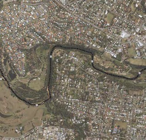
Planning scheme policy – Environmental Areas
and Corridors
                                                                  Table of Contents

Adoption ....................................................................................................................................................... 3

Commencement ........................................................................................................................................... 3

Amendment .................................................................................................................................................. 3

1      Introduction .......................................................................................................................................... 3
    1.1        Purpose ......................................................................................................................................... 3
    1.2        Application ..................................................................................................................................... 3
    1.3        Interpretation .................................................................................................................................. 3

2      Environmental areas ........................................................................................................................... 4
    2.1    Elements of the Environmental Areas Overlay .............................................................................. 4
      2.1.1 High Value Areas .......................................................................................................................... 4
      2.1.2 Value Offset Areas ....................................................................................................................... 5
    2.2    Matters not spatially represented ................................................................................................. 6
      2.1.1    Matters of national environmental significance ..................................................................... 6
      2.1.2    Matters of Local Environmental Significance not spatially represented ............................... 6
      2.1.2.1 Habitat trees and habitat infrastructure [relocated from former section 2.4] ......................... 6
      2.1.2.2   Priority species and their habitat [relocated from former section 3.3] ................................. 6
      2.1.2.3 The koala – a special priority species [relocated from former section 3.3.3] ........................ 7

3      Avoidance and mitigation ................................................................................................................... 8

4      Ecological assessment and reporting ............................................................................................... 9
    4.1 When an ecological assessment report and/or associated plan/s may be required ........................... 9
    4.2 Ecological Assessment Reports ........................................................................................................ 12
    4.3 Survey and monitoring techniques .................................................................................................... 14
      4.3.1 Fauna surveys ............................................................................................................................ 15
      4.3.2 Koala survey .............................................................................................................................. 15
      4.3.3 Vegetation survey ....................................................................................................................... 16
    4.4    Requesting a correction to the matters of local environmental significance overlay mapping .... 17
      4.4.1    How to apply for a map correction for MLES ...................................................................... 17
      4.4.2    Requests about a koala habitat area .................................................................................. 18

5      Fauna Management Plan .................................................................................................................. 18

6       Vegetation Management Plans ........................................................................................................ 18

7      Habitat Tree Management Plan ........................................................................................................ 19

8      Nest Box Management Plan ............................................................................................................. 20

9       Ecological Restoration Plan ............................................................................................................ 21

10         Environmental offsets .................................................................................................................. 22

                                                                                                                                                  Page 1 of 68
10.1        Offset planning and design principles......................................................................................... 23
   10.2 MSES Koala Offsets requirements .................................................................................................. 24
   10.3 MLES offset requirements ............................................................................................................... 24
   10.4 Delivery of Environmental Offsets ............................................................................................... 25
     10.4.1  Notice of Election ................................................................................................................ 25
     10.4.2  Financial Settlements .......................................................................................................... 25
     10.4.3  Offset Delivery Plans for land-based offsets ....................................................................... 25
     10.4.4  Agreed delivery arrangement .............................................................................................. 25
   10.5       Environmental Offsets Receiving Areas ...................................................................................... 25
   10.6       Environmental Offset Receiving Site location hierarchy.............................................................. 27

11         Further reading and resource material........................................................................................ 28

12         Glossary ......................................................................................................................................... 29

End Notes ................................................................................................................................................... 32

APPENDIX 1 – Environmental Areas Overlay – mapped elements detail ............................................ 33

APPENDIX 3 – Design Guide ................................................................................................................... 40

APPENDIX 4 – Priority Species of the Moreton Bay Region ................................................................. 63

APPENDIX 5 – Offset Delivery Plan template ......................................................................................... 66

APPENDIX 6 – Koala Food and Habitat Trees ........................................................................................ 68

                                                                                                                                                Page 2 of 68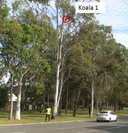
Adoption
Moreton Bay Regional Council adopted this planning scheme policy 24 November 2015.

Commencement
This planning scheme policy will take effect from 1 February 2016[insert date here].

Amendment
Alignment amendment 1 2017
    • Adopted by Moreton Bay Regional Council on 27 June 2017
    • Took effect from 3 July 2017

1       Introduction
This planning scheme policy supports the Moreton Bay Regional Council Planning Scheme and has been
made by Council in accordance with Chapter 2, Part 3, Division 2 of the Planning Act 2016.

1.1     Purpose
This planning scheme policy:

    (a) outlines information Council requires or may requires for the assessment of a development
        application;
    (b) provides guidance and advice for the achievement of outcomes of the Environmental Areas Overlay
        assessment benchmarks;
    (c) provides guidance and advice for developers and decision makers on how development can
        achieve high quality ecologically sustainable development design outcomes;
    (d) provides guidance and advice for counterbalancing environmental values where permitted as a last
        resort, through the use of environment offsets.

1.2     Application
This planning scheme policy applies to development applications (code assessable development and
impact assessable development) for land mapped by the:

    •   Environmental Areas Overlay;
    •   Environmental Offset Receiving Areas Overlay;

This planning scheme policy also informs applies to development affecting matters of national environmental
significance, non-juvenile koala habitat trees, habitat trees and priority species and other species of
importance on land not mapped by the above overlay maps.

1.41.3          Interpretation
Terms used in this planning scheme policy are defined in Schedule 1 – 1.2 Administrative definitions.
Additional terms are also detailed in Section 6 - Glossary.

                                                                                                Page 3 of 68
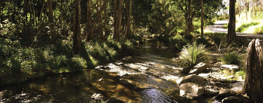
2 Environmental Areas
The Moreton Bay region contains outstanding environmental values including a diverse range of
ecosystems across terrestrial, wetland, waterway, and coastal areas. Thousands of plant, animal, and fungi
species have been recorded in the region, including many threatened species.

Environmental areas are important ecological landscapes vital to protecting and maintaining the ecological
health of the natural environment within the region, that provides ongoing benefit to the community.

Environmental areas support the full spectrum of wildlife lifecycle functions. They include a range of habitat
types from native vegetation, montane, riverine, wetland, and coastal areas to places with scattered
vegetation, any of which may be used by wildlife to forage, move through, breed, shelter and refuge.

Environmental Areas include mapped elements such as matters of state environmental significance (MSES)
and matters of local environmental significance (MLES) and non-mapped elements such as matters of
national environmental significance, non-juvenile koala habitat trees, habitat trees and priority species and
their habitat.

1.32.1            Elements of the Environmental Areas Overlay
The Environmental Areas Overlay represents, where spatially possible, the Moreton Bay region’s most
environmentally important areas recognised as Matters of National Environmental Significance (MNES) 1,
Matters of State Environmental Significance (MSES) and Matters of Local Environmental Significance
(MLES).

Where there is inconsistency between provisions within the planning scheme the overlays prevail over all
other components (other than strategic framework and regulated categories of development) to the extent
of the inconsistency.

2.1.1 High Value Areas and Value Offset Areas

Matters mapped under the Environmental Areas Overlay map are classified into one of two main categories:
High Value Areas or Value Offset Areas.

High Value Areas represent high value environmental matters of State or local significance. These matters
are to be protected from development impacts and cannot be offset. In the limited circumstances where
clearing of native vegetation in a High Value Area is not prohibited by State law or the planning scheme,
impacts will be required to be offset in accordance with the Queensland Environmental Offsets Policy.

Value Offset Areas represent valued environmental matters of State or local significance where offsets
may be allowed if values cannot be avoided or mitigated. For MLES offsets please refer to section 4.3. For
MSES offsets please refer to section 4.2.

    HIGH VALUE AREAS

          Matters of State Environmental Significance (MSES)

    MSES are referenced in the Queensland Government’s State Planning
    Policy 2014. MSES include certain environmental values that are
    protected under Queensland legislation and is generated from
    regulatory data sourced directly from the Queensland government
    including, but not limited to: regulated vegetationregional ecosystem
    mapping; Queensland wetland mapping; protected areas; marine parks;

1MNES – Please refer to the Environment Protection and Biodiversity Conservation Regulations 2000
(Commonwealth)

                                                                                                   Page 4 of 68
wildlife habitat; koala habitat; fish habitat areas; and State legally
 secured offsets.

        Matters of Local Environmental Significance (MLES)

 MLES include environmental values, important to achieving local
 environmental outcomes and that are not already mapped as MSESthe
 same, or substantially the same, as MNES or MSES. Mapped MLES
 areas may contain shorebird habitat areas, biodiversity areas and land
 protected in perpetuity for environmental purposes.

        MLES Wetlands

 MLES wetlands include the internationally locally significant mapped
 Ramsar wetlands where located within the Moreton Bay region and
 other wetlands of significance that are not the same or substantially the
 same already identified as MNES or by MSES.

2.1.2 Value Offset Areas

Value Offset Areas represent valued environmental matters of State or local significance where offsets
may be allowed if values cannot be avoided or mitigated. For MLES offsets please refer to section 4.3. For
MSES offsets please refer to section 4.2.

 VALUE OFFSET AREA

        MSES - Koala Offsets

 MSES - Koala Offsets are areas of Koala habitat within the State
 identified priority areasPriority Koala Assessable Development Area
 and Koala Assessable Development Area. MSES - Koala Offsets are
 generated from regulatory data sourced directly from the Queensland
 government including, that are mapped as bushland habitat areas,
 Hhigh value rehabilitation habitat areas and mMedium Vvalue
 rRehabilitation habitat areas under the South East Queensland Koala
 Conservation State Planning Regulatory Provisions Planning
 Regulation 2017. Where a non-juvenile koala habitat tree is proposed
 to be for cleareding in this mapped area, and the clearing is not
 accepted development, a legally secured offset may be required.

        MLES Waterways buffer

 Land adjacent to waterways requires special management to safeguard
 water quality, water dependent ecosystems and fish habitats. Where
 native vegetation clearing is proposed within an MLES waterway buffer
 (100m, 40m and 20m) and the clearing is not accepted development, a
 legally secured offset is required to ensure water quality outcomes for
 waterways are achieved.

                                                                                               Page 5 of 68
The following buffer distances apply to the following stream orders (as
 measured from the top of the outer bank as defined under the Water
 Act 2000):
     • 100m buffer to W1
     • 40m buffer to W2
     • 20m buffer to W3

        MLES Wetlands buffer

 Where native vegetation clearing is proposed within 100m of mapped
 MLES wetlands, and the clearing is not accepted development, a legally
 secured offset is required to ensure water quality outcomes for wetlands
 are achieved.

Refer to Appendix 1 for a detailed list of all mapped MSES and MLES layers in the Environmental Areas
Overlay.

2.2     Matters not spatially represented
2.1.1   Matters of national environmental significance

Development is to be located in areas to avoid significant impacts on matters of national environmental
significance (MNES) and considers the requirements of the Environment Protection and Biodiversity
Conservation Act 1999.

MNES refer to natural values and features protected under the authority of the Commonwealth
Environmental Protection and Biodiversity Conservation Act 1999 (EPBC Act). In the Moreton Bay region,
Tthis includes but is not limited to:
    • National heritage places.
    • Wetlands of international importance.
    • lListed threatened species and ecological communities.
    • mMigratory species protected under international agreements.

Proponents should refer to the Commonwealth Protected Matters Search Tool for assistance in determining
whether MNES are likely to occur in the project area.

2.1.2   Matters of Local Environmental Significance not spatially represented

3.42.1.2.1      Habitat trees and habitat infrastructure [relocated from former section 2.4]

Habitat trees are trees with large canopies and or structural hollows where animals live, breed and shelter. Many
native animals of Moreton Bay Region are dependent upon habitat trees for their survival. Old and dead trees
can continue to be good habitat trees.

A habitat tree is defined as a native tree with a diameter greater than 80cm at 1.3metres above the ground. It
should be noted that trees not meeting this size may still contain multiple conspicuous hollows and provide
critical habitat for local wildlife.

3.32.1.2.2              Priority species and other native species and their habitat [relocated from
former section 3.3]

3.3.1 What is a priority species?

                                                                                                  Page 6 of 68
Moreton Bay is a region of biological diversity with more than 3000 plant,
animal and fungi species recorded. Of these, 118 are considered to be
priority species.

Priority species generally have one or more of the following traits:
    a. listed as a threatened species (that is extinct in the wild,
         endangered, vulnerable or near threatened or special least
         concern) under State or Commonwealth legislation or international
         agreements;
    b. of management concern within Moreton Bay region;
    c. of scientific interest or at risk (e.g. because of specialised habitat
         requirements or a poorly known species / population);                           Wallum Sedgefrog
    d. are iconic and contribute to regional identity (e.g. Moreton Bay Fig,
         Ficus microphylla).

Local government planning schemes are required by law to recognise and protect matters of state
and national significance including habitats for priority species. Priority species habitat is incorporated
into the Environmental Areas mapping overlay to the extent it can be represented spatially. Scattered and
diffuse native vegetation and habitat values may not be captured in this overlay and must be identified and
valued at development application stage.

Appendix 4 contains a list of Priority species of the Moreton Bay Region.

3.3.32.1.2.3     The koala – a special priority species [relocated from former section 3.3.3]

                                          The koala is a special priority species with significant iconic and
                                          conservation status at local, state and national levels.

                                          Koalas are widely dispersed throughout the Moreton Bay region.
                                          Repeated studies have identified koalas using habitat in rural and
                                          urban areas and often moving between the two.

                                          Koala home ranges vary and are dependent upon habitat
                                          availability and quality and are influenced by local land uses. Many
                                          environmental areas and corridors are likely to contain local koala
                                          habitat and contribute to safe movement of local koalas.

Areas used by koalas for local koala movement or koala habitat area will generally be:
   a. Where koala food and habitat trees are present or
       close by. This includes scattered and isolated gum
       trees in urban environments. Scattered and isolated
       urban trees are often critical ‘stepping stones’ for
       local koalas moving through modified landscapes
   b. Where koalas frequently or transiently use habitat.
   c. Where there exists data, habitat mapping or local
       community observations.
   d. Where there exists a koala sighting within a 1 – 2 km
       range.
   e. Where there exists trace evidence of koala presence
       such as koala scat, scratches on tree trunks.

 Existing scattered and isolated koala habitat trees are often
critical ‘stepping stones’ for local koalas moving through
modified landscapes.

                                                                                                    Page 7 of 68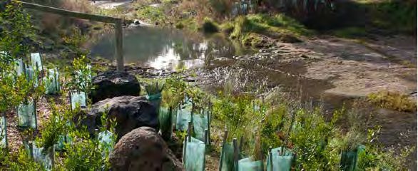
Where scattered gum koala habitat trees and koala sightingsrecords exist within urban areas, all koala
habitat values will be considered important for local and transient koala population viability.

                   Koala scratches on tree trunk                                   Koala scats

3      Avoidance and mitigation
An ‘avoid, mitigate, offset’ framework applies to environmental impacts resulting from development in
Queensland. Applicants must demonstrate avoidance and mitigation of environmental impacts arising from
development. Requirements for demonstrating avoidance and mitigation:

    1. Identify - The environmental values of the area, including MNES, MSES and MLES values, within
       the development site and adjacent areas through ecological assessments.

    2. Avoid - In designing the development, impacts on MNES
       and MSES should in the first place, be avoided wherever
       possible. Where development is proposed that will impact
       on MNES or MSES, it must be demonstrated that it is not
       possible to avoid the impacts.

    1.3. Mitigate - [This section is a copy of the environmental
       outcomes currently contained within the zone codes].
       Development avoids areas subject to constraint,
       limitation, or environmental value. Where development
       cannot avoid these identified areas, it responds by:
            i. adopting a 'least risk, least impact' approach
                 when designing, siting and locating development         Align roads around important trees
                 in any area subject to a constraint, limitation or
                 environmental value to minimise the potential risk to people, property and the environment;
            ii. ensuring no further instability, erosion or degradation of the land, water or soil resource;
            iii. when located within a water buffer area, complying with the Water Quality Vision and
                 Objectives contained in the Seqwater Development Guidelines: Development Guidelines
                 for Water Quality Management in Drinking Water Catchments 2012 environmental values
                 and water quality objectives for waters under the Environmental Protection (Water) Policy
                 2009.
            iv. maintaining, restoring and rehabilitating environmental values, including natural, ecological,
                 biological, aquatic, hydrological and amenity values, and enhancing these values through
                 the provision of planting and landscaping, and facilitating safe wildlife movement and
                 connectivity through:
                      a. the provision of replacement, restoration, rehabilitation planting and landscaping;
                      b. the location, design and management of development to avoid or minimise adverse
                           impacts on ecological systems and processes;
            v. protecting native species and protecting and enhancing species habitat;
            vi. protecting and preserving the natural, aesthetic, architectural, historic and cultural values
                 of significant trees, places, objects and buildings of heritage and cultural significance;

                                                                                                   Page 8 of 68
vii. establishing effective separation distances, buffers and mitigation measures associated
                   with identified infrastructure to minimise adverse effects on sensitive land uses from odour,
                   noise, dust and other nuisance generating activities;
             viii. establishing, maintaining and protecting appropriate buffers to waterways, wetlands, native
                   vegetation and significant fauna habitat;
             ix. ensuring it promotes and does not undermine the ongoing viability, integrity, operation,
                   maintenance and safety of identified infrastructure;
             x. ensuring effective and efficient disaster management response and recovery capabilities;
             xi. where located in an overland flow path:
                       a. development siting, built form, layout and access responds to the risk presented by
                           the overland flow and minimises risk to personal safety;
                       b. development is resilient to the impacts of overland flow by ensuring the siting and
                           design accounts for the potential risks to property associated with the overland flow;
                       c. development does not impact on the conveyance of the overland flow for any event
                           up to and including the 1% AEP for the fully developed upstream catchment;
                       d. development directly, indirectly and cumulatively avoid an increase in the severity
                           of overland flow and potential for damage on the premises or other premises, public
                           lands, watercourses, roads or infrastructure.

          Examples of mitigation measures can be found Appendix 1 Design Guide

     4. Offset - Where it can be demonstrated that further avoidance is not possible, Council will require
         environmental offsets in accordance with the Environmental Offsets Act 2014. Offset conditions will
         only be applied if a suitable offset can be found. In cases where a suitable offset cannot be found,
         the activity might not be approved.

Appendix 4 contains further information on offsets requirements and processes.

24       Ecological assessment and reporting
Ecological assessment is an integral part of the development design and assessment process. The results
and conclusions of an ecological assessment report allows Council to understand if the proposed
development will achieve the performance outcomes required by the Environmental Areas Overlay
assessment benchmarks.

Where a proposed development has the potential to adversely impact on mapped environmental areas,
Council may request an ecological assessment report will be required to inform the development
assessment process. In addition, Council and/or may request associated plan/s to inform the development
assessment process.

   All surveys must be conducted, and reports must be prepared, by persons with relevant tertiary
   qualifications in ecology, conservation biology, natural resource management, environmental science or
   other appropriate ecological professional disciplines.

   Where a specific Information Request is made by Council under the Planning Act 2016 seeking more
   detailed or targeted information than outlined in this guideline, the Information Request takes
   precedence.

2.14.1 When an ecological assessment report and/or associated plan/s
may be required

        TYPE OF REPORT / PLAN                                       WHEN REQUIRED?

                                                                                                      Page 9 of 68
An ecological assessment report is required
when Where a proposed development:
is within or adjacent to areas subject to the
environmental areas overlay.
ECOLOGICAL ASSESSMENT REPORT
Application stage or information request stage Application stage
Includes below three plans where relevant (these has potential to impact on a mapped
may also form conditions of development environmental area
approval prior to Operational Works)
AND
Depending on the scale of development and
impact
When required by the Environmental Offsets
NOTICE OF ELECTION Act 2014.
A vegetation management plan is required
where clearing of native vegetation is
proposed.
As part of an Ecological Assessment Report
VEGETATION MANAGEMENT PLAN OR
Note: an Ecological Restoration Plan may be
required where revegetation is planned. Where an Ecological Assessment Report is
not required
AND
Depending on the scale of development and
impact
FAUNA MANAGEMENT PLAN A fauna management plan is required where
Plan outlining procedures to reduce impacts of
clearing of native vegetation is proposed.
clearing habitat on native fauna.
Information request or decision stage
HABITAT TREE MANAGEMENT PLAN A habitat tree management is required where
Plan outlining procedures to protect habitat trees the site contains habitat trees.
retained within the development site.
NEST BOX MANAGEMENT PLAN A nest box management plan is required
Plan outlining procedures to counterbalance where clearing of native vegetation with
hollow loss. hollows is proposed.
OFFSET DELIVERY PLAN Where an offset requirement is triggered by
Refer to section Error! Reference source the planning scheme.
not found.. Environmental Offsets Act 2014.
Page 10 of 68AGREED DELIVERY ARRANGEMENT
Refer to section Error! Reference source
not found..
ECOLOGICAL RESTORATION PLAN
An Ecological Restoration Plan is required
Refer to section 6.
where revegetation is planned.
Note: nothing within this planning scheme policy limits Council’s discretion to request other relevant
information under the Development Assessment Rules made under section 68(1) of the Planning Act 2016.
Page 11 of 682.24.2 Ecological Assessment Reports
Ecological Assessment Reports must clearly identify any ecological issues environmental values within the
development site and adjacent areas of influence.
The reports must be prepared by persons with relevant tertiary qualifications in ecology, conservation
biology, natural resource management, environmental science or other appropriate professional
disciplines.
Where a specific Information Request is made by Council under the Planning Act 2016 seeking more
detailed or targeted information than outlined in this guideline, the Information Request takes
precedence.
Table 1 below outlines Refer to Appendix 2 for Tthe minimum form and content requestedrequired for
ecological assessment reports. Reports must provide details relevant to the application and site which
enable identification and location of on-ground features, includinge where necessary, images, detailed A3
maps (at a scale not greater than 1:500), figures, tables, development plans and provide details relevant to
the application and site to enable identification and location of on-ground features.
1. Describe the location and extent of the development site and surrounding ecological landscape features:
a. Location.
b. Size.
c. Environmental valuesand ecological features influential to of the site and adjacent areas.
2. Describe the physical characteristics of the site:
a. Geology and soils.
b. Hydrology and water quality (surface and groundwater).
c. Topography, slope and landform.
d. Waterbodies
3. Outline the previous and existing uses of the site and associated details:
a. Existing uses.
b. Previous uses.
c. Existing infrastructure (access routes, transport, water supply, power, communications etc.)
d. Influence of past and present land use on the site, and . Discuss residual effects.
4. Outline field and desktop methodology including:
a. date of survey
b. justification for timing of survey
c. methods, including reference to relevant survey guidelines
d. survey duration
e. weather conditions
f. names and qualifications and relevant experience of professionals that undertook the survey
g. details of relevant permits
h. survey locations
i. justification for survey locations
j. limitations
a.k. and assumptions.
5. Conduct Fauna surveys and vegetation surveys in accordance with section 3.3 Survey and monitoring
techniques. Koala surveys are required if clearing of non-juvenile koala habitat tree(s) is proposed.
Conduct Koala surveys in accordance with section 3.3 Survey and monitoring techniques.
4.6. Provide an accurate description of the characteristics of the site, including Identify and evaluate the
likely presence of flora, fauna, and native vegetationplant communities and discuss wildlife habitat
Page 12 of 68requirements, movement paths, breeding and dispersal behaviours . Identify specific habitat features
available for fauna and indications of fauna presence:
a. Field and desktop methodology and assumptions.
a. Environmental areas including:
i. Matters of National Environmental Significance.
ii. Matters of State Environmental Significance.
iii. Matters of Local Environmental Significance, including:
i. Priority species of the Moreton Bay Region and other species of importance.
ii. Habitat trees, koala habitat trees, heritage trees and street trees.
b. Regional Ecosystems (remnant and non-remnant regrowth) and discuss extent, location,
structure, proportions and condition.
c. Flora species records and presence.
d. Fauna species records and presence as well as .breeding and dispersal behaviours
e.d. Habitat function and ecological processes.
e. Green infrastructure network
f. Environmental corridors Wildlife movement - current and future opportunities.
g. Urban forest canopy composition and coverage
h. Native Vegetation providing ‘stepping stone’ habitat for wildlife.
i. Wildlife movement infrastructure (fences, culverts, rope bridges etc.)
j. Specific habitat features available for fauna
k. Residential gardens contributing green values.
l. Managed forest
f.m. Offset areas, revegetation
g.n. Riparian zone and riparian buffer zone.
h.o. Waterways, watercourses, wetlands, water bodies (inc. dams) and drainage lines
i.p. Water quality and stream health indicators.
j.q. Presence of weed and pest species.
Note: Identification of environmental values The above may include aquatic environmental values and
water quality objectives as required, and BioCondition assessment.
Note: Refer to Section 3.3.23.1 for notes on assessing koala presence koala survey requirements.
1. Identify and discuss the existing local natural values (green infrastructure) of the site:
b. Environment areas
c. Managed forest (plantations, offset areas, revegetation).
d. Environmental corridors.
e.a. Urban forest canopy composition and coverage.
e. Waterways, wetlands, water bodies (inc. dams) and drainage lines.
f. Wildlife movement infrastructure (fences, culverts, rope bridges etc.)
g.a. Vegetation providing ‘stepping stone’ habitat for wildlife.
h. Habitat trees, heritage trees and street trees.
i.a. Residential gardens contributing green values.
11.7. Provide an overview of the proposed development:
a. Type of development.
b. Primary use of development.
b.c. Location and extent of the development site
c.d. All associated infrastructure required for the development.
e. Location and extent of Aall associated operational on site works including i.e. earth works and
native vegetation clearingremoval likely to have environmental impact, with reference to
development plans including version.
d.f. Alternative locations for the development.
Page 13 of 6812.8. Identify Evaluate all potential threatening processes and potential impacts from the proposed
development including:. Detail and discuss mitigation measures appropriate to the scale of impact:
a. Edge effects, including noise and light pollution.
b. Biodiversity and habitat impactsloss.
c. Landscape effects.
d. Invasive species.
e. Downstream effects (including water quality impacts).
13.9. Show a current aerial photos highlighting existing environmental values overlaid with the plan of
development:
a. Remnant regional ecosystems
b. Regrowth regional ecosystems
c. Nonjuvenile koala habitat trees
d. Juvenile koala habitat trees
e. Habitat trees
f. Threatened species records
14.10. Detail and dDiscuss possible proposed avoidance and mitigation measuresactions appropriate to
the scale of impact and including:e the context of
a. dDevelopment design, footprint and location.
b. Alternative location for the development.
c. Minimisation of edge effects.
b.d. Species specific interventions.
c.e. Environmental buffers.
d.f. Revegetation or restoration.
5. Expand upon management strategies to reduce potential impacts to an acceptable level:
f. Development design.
g.a. Alternative location for the development.
h.a. Minimisation of edge effects.
i.g. Landscaping.
j.h. Wildlife movement infrastructure.
k.i. Nest box habitat.
l.j. Fauna management.
m.k. Environmental Offsets.
15.11. List all references used in the information gathering and analysis process and include appendices
for any additional supporting information (including wildlife records and database extractions):
a. Technical information or data.
b. Authorities and agencies consulted – include any correspondence.
c. Background reports and literature reviewed.
2.64.3 Survey and monitoring techniques
Robust and repeatable survey methodologies are important as (a) they provide decision makers with a solid
scientific basis to determine whether a development proposal complies with environmental objectives and
visions, and; (b) provide a baseline event from which to repeat further surveys to determine change over
time.
All surveys and assessments must be conducted by persons with relevant tertiary qualifications in ecology,
conservation biology, natural resource management, environmental science or other appropriate ecological
disciplines or a qualified arborist with experience in completing flora and fauna surveys and assessments.
Requests to undertake surveys and monitoring which deviate from techniques specified in this document
will be a matter for negotiation between the applicant and Council’s Manager Environmental Services,
Page 14 of 68based on the potential environmental impact of the particular development proposed and the
environmental characteristics of the site.
4.3.1 Fauna and Flora surveys
Fauna surveys identify and evaluate the presence of native species and their habitats, movement and
dispersal corridors and pathways. In addition to searches of current literature and ecological databases, this
usually requires a comprehensive site survey using repeatable and approved survey methodology.
Of particular interest are priority species of Moreton Bay Region and those identified as nationally, state or
locally importance including those endangered, threatened, vulnerable or special least concern (refer Nature
Conservation (Wildlife) Regulation (1994, and amended 2006) and Environment Protection and Biodiversity
Conservation Act (1999) and migratory birds protected under international agreements.
Terrestrial vertebrate field surveys are to be consistent with the following accepted methodology:
Eyre TJ, Ferguson DJ, Hourigan CL, Mathieson MT, Kelly, AL, Venz MF & Hogan, LD (2012)(
2018)Terrestrial Vertebrate Fauna Survey Assessment Guidelines for Queensland; Department of
Science, Information and the Arts, Queensland Government, Brisbane.
In addition to the methodology as outlined above, fauna assessment must:
a. If handling, capturing, trapping or taking animals, be undertaken by persons who hold an appropriate
Scientific Purposes Permit from Department of Agriculture and, Fisheries and Forestry, and must
be registered under the Animal Care and Protection Act 2001 and have ethical clearance from an
Animal Ethics Committee
b. describe the fauna habitat significance of the subject site or its sub-components within a local,
bioregional, state and national context;
c. identify any evidence of edge effects, invasive pest species and other disturbances (locations,
causes and levels) which have potential to influence native fauna population viability;
d. identify specific habitat features available for fauna and indications of fauna presence such as:
i. potential habitat trees e.g. containing hollows;
ii. trees with scratch marks;
iii. location and identification of scats, tracks and other traces of fauna;
iv. fruit and seed trails;
v. fauna trails;
vi. fallen logs;
vii. termite mounds;
viii. ground diggings;
ix. rock outcrops;
x. nests in banks;
xi. Roost /nest /den trees.
e. A minimum of four days and nights survey (conducted across several times) to minimise sampling
duration influences within a given sampling period. Upon prior application, Council may allow less
sampling effort iIn some circumstances where less sampling effort is applied, appropriate
justification ismust be provided.
4.3.2 Assessing local Koala presence survey
Key considerations for assessing koala presence include Koala surveys are to be consistent with the
following acceptable methodology:
Page 15 of 68a. A desktop and field assessment of koala
data, sightings and, habitat mapping, and
b. Field assessment of current onsite habitat
values assessment including bushland and
urban habitat values i.e.including groups of
koala food and habitat trees and individual
trees across a site and adjacent to it.
c.a. Where scattered gum trees and koala
sightings exist within urban areas, all koala
habitat values will be considered important
for local and transient koala population
viability.
d.c. Field assessment offor evidence of use by
koalas uUsing a proven valid scientific
methodology for assessing koala presence
and activity such as a transect and spot assessment technique (SAT) . to identify scratches on tree
trunks, scat or any other presence data.
d. Assessment of movement pathways including existing and potential links between koala habitat
areas, within and external to the site.
e. On sites with a limited number of koala habitat trees, a vegetation management plan may be
sufficient.
f. On sites with no koala habitat trees, and where it can be demonstrated that koalas do not traverse the site
to access adjacent habitat and would not benefit from koala sensitive design principles, an ecological
assessment may not be required (note that an ecological assessment may still be required in relation to
other species).
g. Using a proven scientific methodology for assessing koala presence and activity such as a transect
and spot assessment technique (SAT).
4.3.3 Vegetation survey
Vegetation surveys are to be consistent with the following acceptable methodology:
Neldner, V.J., Wilson, B.A., Thompson, E.J. and Dillewaard, H.A. (2012) Methodology for Survey and
Mapping of Regional Ecosystems and Vegetation Communities in Queensland. Version 3.25;
Updated August 20122019; Queensland Herbarium, Queensland Department of Science, Information
Technology, Innovation and the Arts, Brisbane
Biocondition assessments may be required as a remnant vegetation condition assessment tool to provide
a measure of how well a terrestrial ecosystem is functioning for the maintenance of biodiversity values, and
are to be consistent with:
Eyre, T.J., Kelly, A.L., and Neldner, V.J. (2011)(2017). Method for the Establishment and Survey of
Reference Sites for BioCondition. Version 2.0. Department of Environment and Resources
Management (DERM), Biodiversity and Ecological Sciences Unit, Brisbane.
Eyre, T.J., Kelly, A.L, Neldner, V.J., Wilson, B.A., Ferguson, D.J., Laidlaw, M.J and Franks, A.J. (2011).
Biocondition: A Condition Assessment Framework for Terrestrial Biodiversity in Queensland.
Page 16 of 68Assessment Manual. Version 2.1. Department of Environment and Resource Management (DERM),
Biodiversity and Ecosystem Sciences, Brisbane.
Aquatic surveys for water quality and stream health monitoring areis to be consistent with the following
acceptable methodology:
Nolte, U., (2011), Method Manual for Stream Health Monitoring based on macro invertebrate
communities, Moreton Bay Regional Council, Queensland.
In addition to this resource, aquatic surveys will include fauna and flora survey of the waterway, wetland or
water body and adjacent areas of influence. Of particular interest are priority species of the Moreton bay
region.
2.7 Vegetation clearing to support a Bushfire Management Plan
Where native vegetation is proposed for clearing under a bushfire management clearing exemption for a
single property, a competed Individual Property Fire Management Planning Kit (available through the SEQ
Fire & Biodiversity Consortium website) is required to be submitted and approved by Council as a
demonstration of a best practice approach to vegetation clearing for bushfire management for environmental
areas. For larger developments, including a material change of use or reconfiguring a lot, a bushfire
management plan prepared in accordance with Planning scheme policy - Bushfire prone areas is required
to be submitted and approved by Council.
2.84.4 Requesting a correction to the matters of local
environmental significance Environmental Areas Ooverlay mapping
The Environmental Areas - Matters of local environmental significance mapping is reviewed, and refined
where justified, as part of the development assessment process in conjunction with an ecological
assessment report and/or associated plan/s when required.
However, if after viewing the Environmental Areas - Matters of local environmental significance map for your
property you believe the mapping is in error, and you wish to amend the mapping outside the development
assessment process, you can make an application to Council.
Note that fees may apply where a site inspection is required to make a determination on the map change
request.
2.8.14.4.1 How to apply for a map correction for MLES
Your application must include:
• A completed ‘Assessment to change an overlay map’ form (refer to Appendix 3)
• A map showing the current mapped areas versus the proposed mapped areas, and information to
demonstrate how the proposed change will result in increased mapping accuracy. The application
form provides further details of this requirement.
What happens next?
Once your application is accepted, Council will first conduct a ‘desktop analysis’ using the information
supplied in your application, imagery and any other relevant data available. If Council requires extra
information, you will be contacted and a site inspection arranged if necessary.
Note that if a site inspection is required to inform Council’s decision on the map change process then a fee
may apply.
After Council has considered all available information, you will be sent a draft amendmentnotice advising of
the outcome. and advice when tThe amendment will be has been submitted to the state government as part
of the next relevant amendment to incorporated into the planning scheme.
Page 17 of 68If your proposed changes are not accepted, Council will provide you with information detailing the reasons
behind the our decision and offer you the opportunity to supply additional information.
The Environmental Areas overlay map is updated periodically to incorporate changes resulting from map
corrections or development assessment outcomes.
4.4.2 Requests about a koala habitat area
Requests to the assessment manager for changes to the koala habitat values designation can be made in
accordance with Schedule 11 Part 4 of the Planning Regulation 2017.
2.45 Fauna Management Plan
Where development requires clearing of native vegetationhabitat is approved for clearing or a development
has the is approved with potential to impacts on fauna (including modification of farm dams to urban
stormwater management devices) a Fauna Management Plan outlining initiatives management measures
to reduce impacts on native fauna will may be required.
Information to be included in a Fauna Management Plan
Fauna Management Plans must be prepared by persons with relevant tertiary qualifications in ecology,
conservation biology, natural resource management, environmental science or other appropriate ecological
disciplines or a qualified arborist with experience in completing flora and fauna surveys and assessments.
Fauna Management Plans must be based on field assessment of potential fauna habitat including areas in
which protected wildlife (at any stage of its life cycle) may be located.
Fauna Management PlansThe plan must be prepared by a suitably qualified person and must contain at
least the following information:
a. Legislative context, including any approvals, licenses and permits required
b. Management measures to reduce impacts to fauna including:
i. a fauna spotter/catcher undertaking preclearing inspections and being present on site
during clearing.
ii. contact details and qualifications of fauna spotter/catcher; wildlife hospital/vet
c. Procedures for dealing with :
i. relocating fauna observed immediately prior to native vegetation clearing,;
ii. Procedures for dealing with managing fauna during native vegetation clearing,
iii. Procedures for the treatment of injured fauna/ transport from the site,
iv. recording fauna captured, health assessment and relocation, transportation and release.
The Fauna Management Plan must reference each stage of proposed operational works and provide
management measures relevant to the nature and scale of the proposed operational works with relation to
ensuring wildlife safety and detail mitigation strategies in accordance with proposed operational works.
Fauna Management Plans will require approval from Council prior to works commencing, and all associated
works must be carried out in accordance with the approval.
2.36 Vegetation Management Plans
Where native vegetation clearing is proposed habitat is nominated to be cleared within mapped
environmental area a Vegetation Management Plan is required. A Vegetation Management Plan describes
the actions to be used to manage native vegetation before, during and after operational works.
Vegetation Management Plans will address the following criteria:
Vegetation Management Plans must be prepared by persons with relevant tertiary qualifications in ecology,
conservation biology, natural resource management, environmental science or other appropriate
Page 18 of 68professional ecological disciplines or a qualified arborist with experience in completing flora and fauna
surveys and assessments.
Vegetation Management Plans must be based on vegetation assessment/plot survey as per AS4970
Protection of Trees on Development Sites.
The scale of development and anticipated impact on environmental areas will determine the plan’s
requirements.
The Vegetation Management Plans will include:
a. Awill be a series of A3 maps (at a scale not greater than 1:5000) scaled plan showingspatially
representing:
i. location and extent of all operational works, with reference to development plans including
version.
ii. all native vegetation intended to be removed, retained and restored.
iii. In addition, native vegetation type and value (remnant and regrowth regional ecosystems,
habitat trees, juvenile koala habitat trees and non-juvenile koala habitat trees).
iv. Tree Protection Zones and Structural Root Zones
b. Tree management procedures for incursions within these zones.
c. Staged clearing plans (where required) to demonstrate compliance with Part 3 of the Nature
Conservation (Koala) Conservation Plan 2017 or Schedule 11, Part 3 of the Planning Regulation
2017.
a.d. Reuse plans for removed native vegetation.must be provided along with appropriately detailed
information of native fauna impacted by each planned activity identified above.
Where an Ecological Assessment Report is required, the Vegetation Management Plan may form part of
that report.
Where an Ecological Assessment Report is deemed not necessary, a Vegetation Management Plan and
Fauna Management Plan may be required in its place.
Where a Vegetation Management Plan is requested for proposed development within a MSES – Koala
Offset area, the plan must provide the level of detail needed to address the Offset Delivery Plan
requirements as outlined in section 4.2.
Vegetation Management Plans will require approval from Council prior to works commencing.and Aall
associated works must be carried out in accordance with the approval prior to site works.
2.57 Habitat Ttree Mmanagement Pplan
Consideration for the needs of large or hollow bearing trees must be given at the development design stage.
Where the development site contains habitat trees, aAn approved habitat tree management plan will be
required to guide conservation management where habitat trees are retained within the development site.
Consideration for the needs of large or hollow bearing trees must be given at the development design stage.
Habitat tree management plans must be prepared by an arborist with a minimum level 5 qualification.
Minimum information required
Habitat tree management plan
Location and extent of all operational works including earth
works and clearing of native vegetation, with reference to
development plans including version.
Tree species
Size (height, canopy spread)
Estimated age
Location on site
Hollow abundance and estimated sizes
Native species most likely to be using hollow
Page 19 of 68Tree Protection Zones and Structural Root Zones
Tree management procedures for incursions within these
zones.
Vigour (canopy condition etc.)
Current risks to tree health
Location of utilities (above & below ground)
Immediate protective actions required
Maintenance and future management actions
Inspection program Include diagram and / or images of habitat
tree, location and protection zone.
8 Nest Box Management Plan
Clearing of native vegetation with hollows will may necessitate installation of artificial nest boxes to ensure
lost habitat values are at least temporarily counterbalanced.
Where artificial nest boxes are installed a nest box management plan will be required to ensure monitoring
of wildlife use of the nest boxes to determine effectiveness.
Nest box management plans must be prepared, by persons with relevant tertiary qualifications in ecology,
conservation biology, natural resource management, environmental science or other appropriate ecological
disciplines.
Nest box management plans must contain at least the following information:
a. Assessment of the target species
b. Requirements for the target species
c. Nest box types
d. Installation technique
e. Proposed location of the nest box, including GPS location and owners consent
f. Monitoring and maintenance regime details, including protocols for replacing fallen or broken nest
boxes.
Page 20 of 682.49 Ecological Restoration Plan
Ecological restoration assists the recovery of a degraded, damaged or destroyed ecosystem. The objective
of ecological restoration is to create and/or re-instate a self-sustaining plant native vegetation community
that would occur naturally in that particular area and in doing so, establish and enhance wildlife habitat and
improve connectivity. Restoration may also minimise the impacts of storm water run-off on water quality and
help to buffer existing habitat values from edge effects.
Ecological restoration projects use ‘reference ecosystems’ to model project design aspects including
species selection, abundance, and planting densities to create plantnative vegetation communities to reflect
naturally occurring habitats.
In addition to the guidance material outlined in this policy, all revegetation and restoration works should be
consistent with the South East Queensland Restoration Framework. An ecological restoration plan (ERP)
will be prepared and approved before the commencement of any ecological restoration work.
Ecological restoration plans must be prepared by persons with relevant tertiary qualifications in ecology,
conservation biology, natural resource management, environmental science or other appropriate ecological
disciplines.
At a minimum, the plan will include the following information:
a. Scaled map with restoration area clearly defined.
b. Identification of the pre-existing / reference ecosystem to be recreated, giving consideration to
proposed onsite changes as a result of the development including soil type, elevation and
hydrology..
c. Site preparation. Prepare revegetation areas by clearing and/or appropriately managing or treating
weed species. A staged removal of weeds may be necessary to allow native fauna enough time to
move into alternative habitat areas. Council’s Pest Management Plan provides guidance on the
control of declared plant species.
d. Nutrient requirement. Slow release fFertiliser suitable for native plants and water saving devices
such as water crystals as may be required as determined by council.
e. Weed suppression. Blanket mulch restoration area with weed free organic mulch to a minimum
settled depth of 100-150mm. Pre-emergent herbicides may be required to ensure mulching material
remains weed free. Where riparian ecosystems are restored, mulching below top-of-bank is often
impractical. Jute matting or other measures should be applied as appropriate to ensure water quality
is maintained.
f. Natural Biodiversity. Where natural regeneration of plant species is occurring, mulch may be
withheld or applied at to a depth < 100mm only where an approved weed control plan is in place.
g. Species selection. Select plant species consistent with the reference ecosystem for the site and
source from local provenance plant stock where possible.
h. Tube stock is the minimum acceptable size of plant stock for ecological restoration; except where
direct seed methods are applied or where otherwise approved by cCouncil. Tube stock should be
healthy with no signs of root bound, free of pest and disease, true to species and form, sun-
hardened, and self-supporting.
i. Environmental processes that impact on restoration must be managed. Where appropriate treat
erosion prone areas with Jute mat / geo-fabric and plant at higher densities to mitigate erosion
potential. Earthwork may be required to assist planting and maintenance access and minimise
erosion processes.
j. Position maintenance tracks to minimise edge effects and avoid fragmentation of the restoration
site.
k. Site protection. Protect revegetation works from browsing by herbivores through appropriate
measures such as exclusion fencing, tree guards, chemical products etc. Barbed wire is not
acceptable. Signage may be necessary to ensure awareness of restoration activities.
Page 21 of 68You can also read