COASTAL ZONE MANAGEMENT PLAN WHARF ROAD NORTH BATEMANS BAY - NOVEMBER 2016
←
→
Page content transcription
If your browser does not render page correctly, please read the page content below
COASTAL ZONE MANAGEMENT PLAN

                WHARF ROAD
        NORTH BATEMANS BAY

NOVEMBER 2016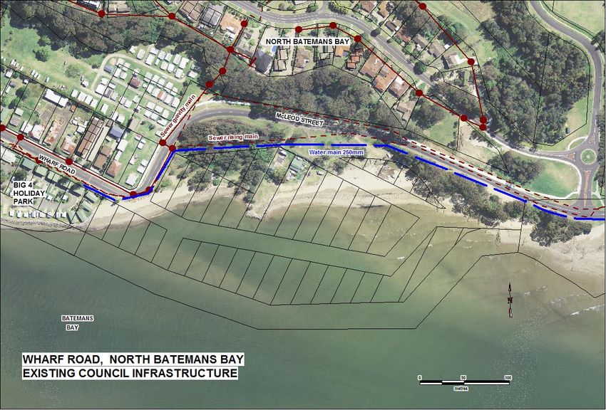
DRAFT COASTAL ZONE MANAGEMENT PLAN
                                      WHARF ROAD NORTH BATEMANS BAY

                                                             CONTENTS
1.      INTRODUCTION ......................................................................................................... 1
     1.1 BACKGROUND .................................................................................................................. 1
     1.2 S55 DIRECTIVE ................................................................................................................. 3
     1.3 COASTAL ZONE MANAGEMENT PLAN AREA ........................................................................... 3
     1.4 PAST STUDIES .................................................................................................................. 3
     1.5 PRIORITY ISSUES ............................................................................................................... 4
     1.6 MANAGEMENT OPTIONS .................................................................................................... 4
     1.7 CURRENT STRATEGY .......................................................................................................... 4
       1.7.1 Emergency action sub-plan ..................................................................................... 4
       1.7.2 Zoning ...................................................................................................................... 5
     1.8 CONSULTATION ................................................................................................................ 5
     1.9 HOW WE MEET THE COASTAL MANAGEMENT PRINCIPLES, GOALS AND OBJECTIVES ......................... 5
2.      COASTAL PROCESSES ............................................................................................... 10
     2.1       SEDIMENT SUPPLY .......................................................................................................... 10
     2.2       RIVER FLOODING ............................................................................................................ 10
     2.3       OCEAN INUNDATION ....................................................................................................... 12
3.      COASTAL HAZARDS AND RISKS................................................................................. 14
     3.1      EROSION ....................................................................................................................... 14
     3.2      BEACH RECESSION .......................................................................................................... 15
     3.3      OCEAN INUNDATION ....................................................................................................... 16
     3.4      WAVE RUNUP ............................................................................................................... 17
     3.5      COASTAL HAZARDS RISK MANAGEMENT OPTIONS .................................................................. 17
     3.6      COSTS AND BENEFITS OF MANAGEMENT OPTIONS .................................................................. 19
     3.7      HAZARD VULNERABILITY CATEGORIES……………………………………………………………………………..19
4.      COASTAL & ESTUARINE ECOSYSTEMS....................................................................... 20
5.      COASTAL / ESTUARY VALUES ................................................................................... 20
     5.1       ECOLOGICAL .................................................................................................................. 20
     5.2       CULTURAL ..................................................................................................................... 21
     5.3       SOCIO-ECONOMIC .......................................................................................................... 21
6.      COMMUNITY USES .................................................................................................. 22
     6.1       ACCESS ......................................................................................................................... 22
     6.2       AMENITY ...................................................................................................................... 23
7.      COASTAL MANAGEMENT STRATEGY ........................................................................ 23

i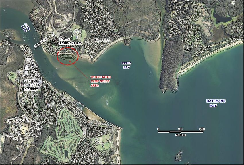
7.1     COMPLETED ACTIONS ...................................................................................................... 23
     7.2     ACTIONS FOR FUTURE IMPLEMENTATION ............................................................................ 25
     7.3     ACTIONS IMPLEMENTATION SUMMARY ............................................................................... 27

8.     MONITORING AND REVIEW ..................................................................................... 28
9.     REFERENCES ............................................................................................................ 30

                                                            FIGURES

FIGURE 1 LOCALITY - WHARF ROAD, NORTH BATEMANS BAY................................................................. 1
FIGURE 2 WHARF ROAD ‘HOTSPOT’ STUDY AREA ................................................................................ 2
FIGURE 3 SEDIMENT TRANSPORT MECHANISMS IN BATEMANS BAY ....................................................... 11
FIGURE 4 EXTRACT FROM WMA 2001 SHOWING FORESHORE LOCATIONS AND INUNDATION LEVELS
    (EXCLUDING WAVE SETUP) ....................................................................................................... 12
FIGURE 5 EXTRACT FROM WRL 2012 SHOWING COASTAL EROSION ....................................................15
FIGURE 6 POTENTIAL INUNDATION AREAS FOR WHARF ROAD DURING 1% AEP EVENT ......................16
FIGURE 7 AREAS OVERTOPPED BY WAVE RUN-UP ………………………………………………………………………………………… 17
FIGURE 8 EUROBODALLA LOCAL ENVIRONMENTAL PLAN 2012 LUND USE ZONING………………………………………..24
FIGURE 9 COUNCIL INFRASTRUCTURE IN STUDY AREA……………………………………………………………………………………26
FIGURE 10 ACTION PLAN SUMMARY – WHARF ROAD CZMP…………………………….………………………………………………29

                                                              TABLES

TABLE 1 CONSIDERATION OF COASTAL MANAGEMENT PRINCIPLES, GOALS AND OBJECTIVES IN CZMP
    PREPARATION ......................................................................................................................... 7
TABLE 2 LOCALLY ADJUSTED SEA LEVEL RISE PROJECTIONS ................................................................... 13
TABLE 3 ADOPTED INUNDATION LEVELS FOR WHARF ROAD (WBM, 2008) INCLUSIVE OF UPDATED SLR ... 13
TABLE 4 LISTED BIRD SPECIES KNOWN TO UTILISE BATEMANS BAY ESTUARY ............................................ 20
TABLE 5 ACTIONS IMPLEMENTATION SUMMARY ............................................................................... 27

ii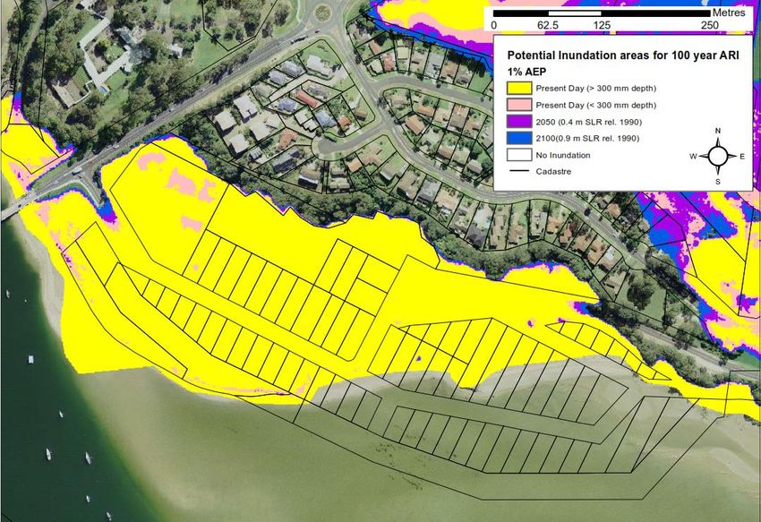
APPENDIX

APPENDIX 1   LAND USE OBJECTIVES                                   31
APPENDIX 2   LAND USE MATRIX                                       33
APPENDIX 3   EMERGENCY ACTION SUB-PLAN FOR THE WHARF ROAD          34
APPENDIX 4   JUDGMENT FROM THE LAND AND ENVIRONMENT COURT OF NSW   47

iii
COASTAL ZONE MANAGEMENT PLAN
WHARF ROAD NORTH BATEMANS BAY
1. INTRODUCTION
1.1 Background
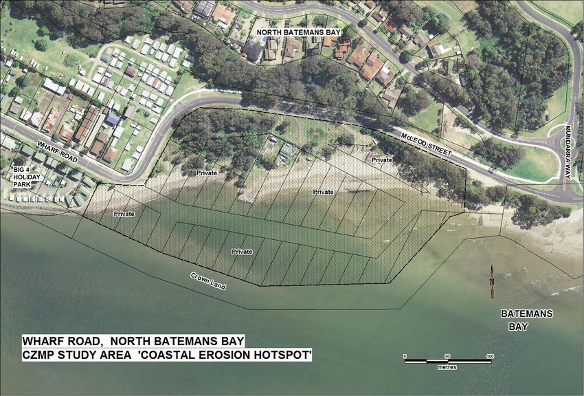
Batemans Bay is a regional coastal centre 340km south of Sydney in the Eurobodalla Shire.
The Wharf Road area is on the northern sandy shoreline of Batemans Bay, 480 metres
downstream of the Princes Highway Bridge over the Clyde River (located on Figure 1).
Fi gu r e 1 : Lo ca l it y - Wh a r f Ro ad , No r th B at em an s B a y
The back beach area at Wharf Road is low lying, and subject to immediate coastal
inundation and erosion hazards. Assets and infrastructure include approximately 8 hectares
of private property (some submerged), a public road and unformed (Crown) road reserves.
Water and sewerage infrastructure are present in the back beach and high hazard area
below ground.
The NSW Government has identified this part of Batemans Bay as a coastal erosion
‘hotspot’, requiring the preparation of a Coastal Zone Management Plan (CZMP) and
Emergency Action Sub-plan (EAS).
1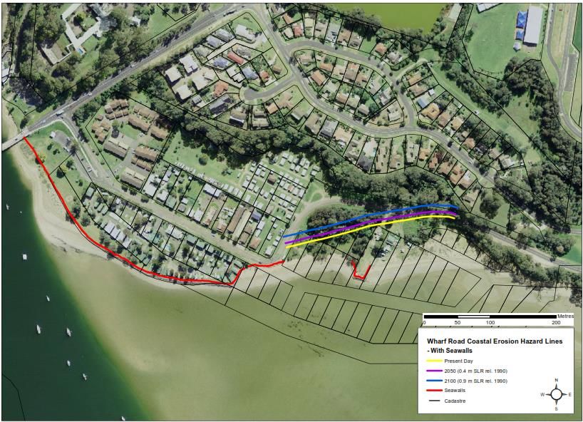
Fi gu r e 2 : Wh ar f Ro ad ‘ H o tsp o t ’ Stu d y Ar e a

2
1.2 Section 55 Directive
Under the provisions of section 55B of the Coastal Protection Act 1979 (the Act), a Directive
to submit a Draft Coastal Zone Management Plan for the coastline within Batemans Bay
between the Princes Highway Bridge and the Mundarra Way intersection was issued by The
Hon Frank Sartor M.P. on 25/2/2011. The area identified within directive specifically refers
to “the coastline that is a beach” and can reasonably exclude the eastern rock headland and
the existing coastal protection works adjacent to the Big 4 Holiday Park. The beach within
the study area is included on the schedule of coastal erosion hotspots in NSW.
This Plan has been prepared in accordance with Part 4A of the Act to comply with the
Minister‘s Directive.

1.3 Coastal Zone Management Plan area
This plan applies to the beach and foreshore area from south-east of the Big 4 Holiday Park
(on Wharf Road) extending approximately 450 metres to the east (see Figure 2). It
comprises 41 privately owned residential lots, road reserve and Crown Reserve, all of which
were created by subdivision (when the shoreline was accreted) during the 1890s.

1.4 Past studies
Relevant studies of the coastal processes of Batemans Bay date back to the 1980’s. The Public
Works Department’s 1989 Batemans Bay Inundation Study predicted storm surge levels along
the Batemans Bay coastline. In 1996 the results of detailed modelling of ocean storm
processes and photogrammetric analysis of beach recession were presented in the Batemans
Bay Vulnerability Study (DLWC 1996).
The Estuary Processes Study for Batemans Bay (WBM 1999) examined sedimentation
processes in the inner bay. This incorporated aerial photographic analysis, numerical
modelling of waves and hydrodynamic modelling to explain sediment movement and
shoreline behaviour at locations including the subject land.
The Draft Batemans Bay Coastline Hazard Management Plan was prepared for Council in 2001
(Webb McKeown & Associates - WMA - final version is dated September 2006). This report
defined coastal hazards and provided information upon which council has based its planning
decisions along the Batemans Bay shoreline for the last 15 years. This document remains
current until a revised plan for the Batemans Bay shoreline (in preparation) with updated sea
level rise information is adopted. The WMA report included Wharf Road in two precincts -
west and east - with the east precinct corresponding to the study area.
The 2008 Wharf Road Coastal Hazard Assessment and Hazard Management Plan (BMT WBM
May 2008) further refined the level of knowledge on the behaviour of the subject land under
coastal processes.
The historic shoreline behaviour analysis at Wharf Road was analysed and the estuarine
processes within Batemans Bay were described. Percentage exceedance lines for the
historical shoreline alignment were identified and storm tide levels including sea level rise

3
were calculated. It was found that the Wharf Road east precinct will be impacted by non-
storm tidal inundation by year 2100. Coastal values and the significance of the Clyde River
estuary and Batemans Bay were described. Management options were assessed and ranked.
Voluntary acquisition was selected as the preferred option.

1.5 Priority issues
Coastal inundation poses a serious risk to existing development along the Wharf Road
coastal strip. Inundation depths in a current 1% ocean storm of up to 0.6 metres combine
with potential wave runup to effectively prevent future development.
The risk of ocean inundation of the Wharf Road area would be significantly increased due to
future SLR that is expected to occur in association with global warming. Sea level rise of
0.9m (expected on the Eurobodalla coast after year 2100) would elevate the Highest
Astronomic Tide (HAT) level to around 1.9 m AHD, which would result in ocean inundation
of the Wharf Road precinct in the absence of storm surge and wave effects. (BMT WBM
2008).
In addition this part of the bay coastline is subject to a variable supply of sediment from the
inner bay shoals, with potential for large shoreline fluctuations in both the medium and
short term.
Beaches, tidal and sub-tidal areas of the estuary are under private ownership. The
unavailability of legal public access to these beaches and indeed to the waters of the bay is a
major amenity issue.
The area contains public infrastructure, including public roads, water and sewer mains that
are under threat of wave attack and erosion.

1.6 Management options
Several management options to address the identified coastal issues at Wharf Road were
formulated and reviewed in the Batemans Bay Coastline Hazard Management Plan (WMA
2001 and 2006). These options were further refined in the Wharf Road Coastal Hazard
Assessment and Hazard Management Plan - Preliminary Draft (BMT WBM 2008).
The full range of management options relevant to Wharf Road east are detailed in Section
3.4 of this plan.

1.7 Current strategy
The current management strategies enacted to date by Council are summarised below.
       1.7.1 Emergency action sub-plan
       A Draft Emergency Action Sub-plan for the Wharf Road Coastal Erosion ‘Hot Spot’
       (Umwelt (Aust) Pty. Ltd. 2012) was adopted by Council on 24 July 2012. See Section
       7.1 for details.

4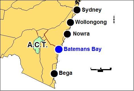
1.7.2 Zoning
       Council has acted to zone the whole of the subject land E2 Environmental
       Conservation under the Eurobodalla Local Environmental Plan 2012 in accordance
       with recommendations of BMT WBM 2008. This zone was applied to wetlands,
       littoral rainforests and some foreshore areas across the shire. The strategy aims to
       avoid current and future risk by preventing development unsuited to a high hazard
       coastal area.

1.8 Consultation
Public consultation over the use of the Wharf Road area has been ongoing since 2004 with
the preparation of an Estuary Management Study and Plan for the Batemans Bay and Clyde
River estuary. This consultation was broad in scope, indicative of the public’s wider values
and issues at that time.
More localised public comments were lodged with Council in response to a proposal for
development of a number of residential units at Wharf Road East, reported in BMT WBM
(2008). As summarised in this plan under the section Socio-economic values, this provided
opportunity to examine the values that the public placed specifically on the Wharf Road
locality.
In developing the Wharf Road Coastal Hazard Assessment and Hazard Management Plan
(BMT WBM 2008), the consultants convened a public information meeting in Batemans Bay
on 19th November 2008. A total of five written submissions and one petition were received
following the public information meeting.
Consultation with the public and State agencies on the management of this area continued
with the exhibition of the Emergency Action Sub-plan for the Wharf Road Coastal Erosion
‘Hot Spot’. The Emergency Action Sub-plan was on public exhibition for the minimum
period required of 28 days ending 4 July 2012. Written notification of the exhibition was
forwarded to each property owner.
A total of one written submission was received during the exhibition period. The submission
supported the initiative of Council in preparing the EAS. Council formally adopted the EAS
on 24 July 2012.
This draft CZMP would be publicly exhibited for a minimum of 21 days in accordance with
guidelines. No further public consultation is proposed in consideration of the prior public
involvement to date.
Council would then consider all submissions, amend the draft as necessary and submit to
the Minister for certification.

1.9 How we meet the coastal management principles, goals and objectives
The 2013 Guidelines for Preparing Coastal Zone Management Plans (referred to hereafter as
the Guideline) set out ten principles for preparing CZMPs.

5
Table 1 overleaf demonstrates how these guidelines, the objectives of the Coastal Protection Act, and the goals of the NSW Coastal Policy interact (SMEC 2015). Many of the principles, goals and objectives are similar and have been grouped against the Guideline principles in Table 1. This table shows how these statutory requirements have been considered in preparing this CZMP. 6
Table 1             Consideration of Coastal Management Principles, Goals and Objectives in CZMP Preparation

     Guidelines for Preparing CZMPs -                 Coastal Protection Act                                NSW Coastal Policy                     How Principles, Objectives and
                 Principles                                - Objectives                                          - Goals                           Goals have been considered in
                                                                                                                                                                 CZMP
    1. Consider the objectives of the     To encourage, promote and secure the orderly        Providing for ecologically sustainable            No reliance in this plan on structural
    Coastal Protection Act 1979 and the   and balanced utilisation and conservation of        development and use of resources.                 protection to defend an inherently
    goals, objectives and principles of   the coastal region and its natural and man-                                                           hazardous zone. Allows shoreline
    the NSW Coastal Policy 1997 and the   made resources, having regard to the                                                                  fluctuations in line with natural
    NSW Sea Level Rise Policy Statement   principles of ecologically sustainable                                                                processes and future SLR. (Section
    2009.                                 development.                                                                                          7.1)
                                                                                                                                                Provision for weed & rubbish control
                                                                                                                                                and amenity improvements when
                                                                                                                                                private lands placed into public
                                                                                                                                                ownership (Section 7.7).
                                          To recognise and foster the significant social      Providing for ecologically sustainable human      Development of this high risk area
                                          and economic benefits to the State that result      settlement in the coastal zone.                   not appropriate. Plan allows
                                          from a sustainable coastal environment,             Protecting and enhancing the aesthetic            shoreline fluctuations in line with
                                          including:                                          qualities of the coastal zone.                    natural processes rather than
                                          - benefits to the environment,                                                                        visually obtrusive protective
                                          - benefits to urban communities, fisheries,                                                           structures. (Section 7.1)
                                          industry and recreation,
                                          - benefits to culture and heritage, and
                                          - benefits to the Aboriginal people in relation
                                          to their spiritual, social, customary and
                                          economic use of land and water.
                                          To provide for the acquisition of land in the                                                         Acquisition of properties and sandy
                                          coastal region to promote the protection,                                                             beaches proposed for access and
                                                                                                                     -
                                          enhancement, maintenance and restoration of                                                           enhancement of these currently
                                          the environment of the coastal region.                                                                privately owned areas. (Section 7.2)
                                                                                              Protecting and conserving the cultural heritage   No actions relate directly to
                                                                  -
                                                                                              of the coastal zone.                              preservation of heritage.
    2. Optimise links between plans       To ensure co-ordination of the policies and         Providing for integrated planning and             There are no actions that are reliant
    relating to the management of the     activities of the Government and public             management of the coastal zone.                   on other plans for implementation.
    coastal zone.                         authorities relating to the coastal region and to
                                          facilitate the proper integration of their
                                          management activities.

7
3. Involve the community in To recognise the role of the community, as a Providing information to enable effective Recommended management actions
decision-making and make coastal partner with government, in resolving issues management of the coastal zone. recognise community input. A
information publicly available. relating to the protection of the coastal summary of consultation activities is
environment. provided in Section 1.8.
4. Base decisions on the best Recognising and accommodating the natural The technical studies referred to in
available information and reasonable processes of the coastal zone. Section 1.4 provide detailed
practice; acknowledge the information on estuarine and coastal
interrelationship between processes to the best current
catchment, estuarine and coastal - standards. These studies document
processes; adopt a continuous the natural processes and other
improvement management information that was used to assess
approach. coastal hazards and management
options.
5. The priority for public expenditure The general public and future
is public benefit; public expenditure generations would benefit from
- -
should cost-effectively achieve the acquisition of private land at Wharf
best practical long term outcomes. Road. (Section 7.2)
6. Adopt a risk management High risk of development is avoided
approach to managing risks to public by appropriate land zoning. (Section
safety and assets; adopt a risk 7.1)
management hierarchy involving Council assets require assessment
avoiding risks where feasible and for long term protection or
mitigation where risks cannot be relocation. (Section 7.2)
- -
reasonably avoided; adopt interim The Wharf Road Emergency Action
actions to manage high risks while Sub-Plan (Umwelt 2012) identifies
long-term options are implemented. actions to manage risks to public
safety in the event of a coastal
erosion or inundation emergency.
(Section 7.1)
7. Adopt an adaptive risk To encourage and promote plans and Locally adjusted sea level rise
management approach if risks are strategies for adaptation in response to coastal projections have been developed
expected to increase over time, or to climate change impacts, including projected - (Whitehead 2014) and are used in
accommodate uncertainty in risk sea level rise. the review of coastal hazards and
predictions. management options. (Section 2.3)
8. Maintain the condition of high To protect, enhance, maintain and restore the Protecting, rehabilitating and improving the No high value ecosystems exist
value coastal ecosystems; environment of the coastal region, its natural environment of the coastal zone. locally at Wharf Road. (Section 4)
rehabilitate priority degraded coastal associated ecosystems, ecological processes
ecosystems. and biological diversity, and its water quality.
89. Maintain and improve safe public To promote public pedestrian access to the Providing for appropriate public access and Provision for enhanced public access
access to beaches and headlands coastal region and recognise the public’s right use. to by Council once land in public
consistent with the goals of the NSW to access. ownership.
Coastal Policy. Public access to beaches would be
reinstated by acquisition of key
properties. (Section 7.2)
10. Support recreational activities To promote beach amenity. As above. Public access to beaches for walking,
consistent with the goals of the NSW swimming, wading and sightseeing
Coastal Policy. would result from the acquisition of
key properties. (Section 6)
92. COASTAL PROCESSES The Wharf Road area is subject to a complex interaction of forces from tidal currents, river floods and ocean waves. Wave influences are dominant during major ocean storm events with larger ocean waves from the southern to eastern quarter in particular propagating into the area. 2.1 Sediment Supply Routine low to moderate wave action and ebb / flood tidal currents interact to cause slow but significant progressive sand transport and shoreline changes. Waves are dominant in moving sand from the ramp margin shoal onshore to Surfside Beach and Wharf Road. Wave induced sand movement at Wharf Road is along the shoreline, predominantly towards the west. Sand transport rates are variable, ranging from persistent low rates to occasional short term high rates of transport during storms. Strong ebb currents dominate during major river flood events. These irregular events can cause gross re-distributions of sand in the offshore direction in a short time. They can break through the river mouth shoals as occurred in 1964 and recurred in August 2015. This mechanism is largely responsible for supply of sand to Surfside Beach, which in time can resupply the Wharf Road area. A conceptual model of sand transport pathways within the inner Batemans Bay was reworked by WBM (1999) from a Patterson Britton & Partners study of nearby Cullendulla Beach (PBP 1992) and is reproduced here in Figure 3. The natural sediment system of the inner bay is highly dynamic and at Wharf Road is the accumulated net result of many factors, some of which are slow and progressive while others are unpredictable and infrequent but of relatively major influence. 2.2 River Flooding Flooding of the Clyde River can combine with elevated ocean levels to inundate the Wharf Road foreshore. A 5% river flood event is predicted to add an estimated 0.1m to inundation levels at Wharf Road (WMA 2006). An allowance for 5% river flooding has been adopted in determining inundation levels for the study area (see below). 10
Fi gu r e 3 : Sed im en t Tr an sp o r t M ech an i sm s i n B a tem an s B a y (a fter P atte r son B r itton &
Par tn er s 1 9 9 2)

11
2.3 Ocean Inundation
Some 80% of the subject ‘land’ is covered by tidal waters within the estuary. The land-
based portions of the study area are low lying and subject to inundation from oceanic
processes.
Wharf Road would experience nearshore wave heights of 1.3 metres during a 1% ocean
storm with an offshore significant wave height of 10 metres (Webb McKeown 2006). At the
peak of this event, the Wharf Road area would experience elevated water levels estimated
by WMA at 1.8m AHD in the nearshore zone. In addition, localised wave setup would be
generated due to waves breaking on the shoreline. WMA adopted a conservatively low
wave setup value for a 1% storm of 0.25 metres at Wharf Road.
Note that numerical modelling undertaken in WBM (1999) suggested that significant wave
setup (~0.4m) could be generated across the central and inner bay in general, due to waves
breaking in the outer bay. The later assessment by BMT WBM (2008) includes a total
allowance of 0.6m for wave setup at Wharf Road.

Fi gu r e 4 : Ex tr act fr o m WM A 20 01 sh o w in g for esh or e lo cat ion s an d in u n d at ion le ve l s
(exc lu d in g wa ve set u p )

Figure 4 is extracted from the WMA 2006 Coastal Zone Management Plan to show the
projected inundation levels excluding wave setup and the approximate range of shoreline
movement experienced at Wharf Road.
Future sea level rise (SLR) impacts are projected to be more severe than the 0.2 metre
allowance used by WMA. Current SLR projections adopted by council after a regional study
(Whitehead and Associates, 2014) are shown in Table 2.

12
The potential for inundation in the future will be more regular than identified in the report
by WMA. Note that these conservative WMA levels will be revised, applying the current
projections for sea level rise adopted by council, in a forthcoming coastal report for
Batemans Bay in preparation.

Tab le 2: Loc a ll y ad ju st e d se a le ve l r is e p r oj ect i on s

(from Whitehead and Assoc, 2014)

       Year           Locally Adjusted Sea Level Rise
                                Projection
                                         (m)
       2015                               0.00
       2020                               0.03
       2030                               0.10
       2040                               0.15
       2050                               0.23
       2060                               0.30
       2070                               0.39
       2080                               0.50
       2090                               0.61
       2100                               0.72
       2100+                              1.00

Table 3 below shows Council’s latest adopted inundation levels for the Wharf Road study
area, incorporating an updated SLR component to year 2065 from Whitehead 2014.

Tab le 3: Ad o p ted In u n d at io n L e ve ls for Wh ar f Road ( W B M , 2 00 8) in c lu si ve of u p d at ed
SL R

       Annual           Astronomic         River Flooding       Sea Level Rise    Wave            Cumulative
     Exceedance        Tide & Storm          Allowance             (m) *         Induced          Water Level
     Probability           Surge                 (m)                              Setup            (m AHD)
                         (m AHD)                                                   (m)
         5%                 1.4                   0.1                 0.34         0.6                2.44
         2%                 1.45                  0.1                 0.34         0.6                2.49
         1%                 1.5                   0.1                 0.34         0.6                2.54
*         Note: a projection of 34cm is applied for the 50year planning period to year 2065.

Council’s LiDAR mapping indicates natural surface levels around 1.6m to 1.7m AHD in front
of the existing development, with isolated patches 1.9m to 2.0m AHD on the back beach
area blocks. The Wharf Road roadway is at an average elevation of 1.5m to 1.6m AHD with
McLeod Street at 1.6m to 1.7m AHD.

13
The front beach blocks are at or below 0m AHD rising to 1.6 at the foredune. The current day 63% AEP (1year ARI) ocean inundation event for the site is 1.2mAHD (excluding wave run-up). The elevation of the site allows high frequency events to inundate large areas of the land. Larger events inundate the entire site. Current ocean inundation events can result in a still water depth of around 0.6m over Wharf Road and 0.5m on the subject lands. With the advent of sea level rise, 1% ocean storm inundation depths would be 0.9 metres by year 2065. 3. COASTAL HAZARDS AND RISKS 3.1 Erosion The Wharf Road precinct shoreline was substantially accreted during the 1890’s when the now largely submerged subdivision was created. More recently, this area has experienced severe erosion such as the post-storm profiles in the mid 1970’s, with erosion to the extent that all but three of the residential allotments were adversely affected. Storm erosion occurs on the shortest of timescales during a severe storm. WBM BMT (2008) surmised that a 1% AEP ocean storm with a 1.6 m AHD storm tide level and 1.4 m breaking wave height would have the potential to cause in the order of 20 m 3/m erosion above 0 m AHD. This would amount to about 10-15 metres of ‘storm bite’ along the currently unprotected eastern segment of beach at Wharf Road. Medium term cycles of substantial erosion/accretion have been observed to occur at Wharf Road. As discussed in the Estuary Processes Study (WBM, 1999), these arise from a complex interaction of morphological processes driven by waves, tides and infrequent river flooding. WBM BMT (2008) concluded that these cycles could produce an equilibrium shoreline well landward of its current location. Future sea level rise is likely to significantly increase the erosion hazard posed to Wharf Road east, such that it can be expected that all residential allotments in this precinct will be at significant risk from erosion events over a 100-year planning period. The presence of any ‘hard’ structures in the active beach zone along the eastern Wharf Road shoreline has the potential to induce localised erosion above and beyond the natural cycles described above. In particular, a “groyne” structure can cause some localised accretion on the updrift (eastern) side and localised erosion on the downdrift (western) side. While offering a level of protection from ongoing erosion to the updrift beach, its effectiveness in a period of sand supply deficit would be limited. A preliminary assessment of coastal hazards undertaken by WRL in 2012 in association with the Eurobodalla Coastal Zone Management Plan confirmed the site to be at immediate risk from coastal hazards. Figure 5 below is an extract from the preliminary assessment which presents a deterministic representation of coastal erosion at the site out to 2100. The 2015 14
hazard line most closely aligns to Council’s adopted projection for sea level rise out to 2065
(34cm).
The presence of the seawall was not considered in the assessment for the following reasons:
Not a legally approved structure
Not on council land and therefore not maintained by council
Not built to engineering standards therefore long-term function not guaranteed
No guarantee of long term maintenance.
Fi gu r e 5 : Ex tr act fr o m WR L 2 0 12 sh o win g coa s ta l er o si on
3.2 Beach Recession
Beach recession is defined as a progressive long term loss of beach width. Erosion and
accretion of sand in the Wharf Road compartment is a result of the combination of coastal
and fluvial processes and does not represent beach recession.
15SMEC (2010) concludes that for beaches that are within estuaries such as Wharf Road would not necessarily undergo future recession related to SLR as the offshore profile is dominated by the dynamics of the tidal delta and sediment transport processes. 3.3 Ocean Inundation The major hazard identified by the 2001 CHMP for the Wharf Road precinct is ocean inundation as a result of high astronomic tides combined with storm surge (wind stress and barometric effects during major storms), together with additional minor Clyde River flooding effects. Additional wave setup in the inner bay plus wave runup overtopping the low foreshore adds to the hazard. Based on the latest levels determined by WMA (2008), coastal inundation poses a serious current risk to existing development along the Wharf Road coastal strip. The back beach area would be inundated by around 0.5m of still water in a current 1% ocean storm event without wave runup. Broken waves would pass across the subject land increasing the depth of inundation with each pulse of waves. Future sea level rise would increase the frequency of inundation events. By year 2065 the 1% ocean storm inundation depth would increase to 0.8 metres. Sea level rise of 0.9m is projected in the Eurobodalla after year 2100. This would elevate the Highest Astronomic Tide (HAT) level to around 1.9 m AHD, which would result in ocean inundation of the Wharf Road precinct in the absence of storm surge and wave effects. Fi gu r e 6 : P o ten t i al In u n d at io n Ar ea s for Wh ar f Ro ad d u r in g 1% A EP e ve n t ( WRL , 2 01 2) 16
3.4 Wave Runup
Potential wave runup with greater than a 5% AEP ocean storm would impact on the whole
of the foreshore lands at Wharf Road east, with inundation extending across McLeod Street
and Wharf Road. BMT WBM calculate wave runup at Wharf Road east at the peak of a 1%
ocean storm to potentially extend a further 1.5m in elevation.
SMEC (2011) calculated wave run-up at the site at 2.95mAHD. Figure 6 below maps the
extent of current day maximum wave run-up from the SMEC report. The whole site is
inundated, including access along Wharf Road.

Fi gu r e 7 : Ar ea s o ver t o p p ed b y w av e r u n -u p ( S M E C 2 0 11)

3.5 Coastal hazards risk management options
The management options relevant to the study area at Wharf Road East developed in WMA
2001 are discussed as follows:

Environmental Planning:
Restrictive zonings
Due to the relatively low number of private land holdings in the Wharf Road East precinct
that are currently developed, rezoning of the entire study area was recommended by WMA
and has been acted upon by Council. This approach is in keeping with the NSW Coastal
Policy goals and objectives.

17
This option would allow for the Wharf Road east precinct shoreline and backshore zone to
naturally accommodate the coastal inundation and erosion that it is likely to experience in
the future.
Land purchase
The return of beaches to public ownership has long been a foundation of the coastal
management approach in NSW. There are currently 15 private lots wholly under water and
two 200m lengths of sandy beach under private ownership above the High Water mark. The
submerged lots and those areas of the beach below high water have automatically been
vested in the Crown.
Areas of beach and foreshore above High Water remain in private ownership and are a
priority for acquisition under this Plan.
Development Controls:
       - minimum floor levels,
       - building protection (raised floors & hazard proofing).
Development controls for the eastern Wharf Road precinct are impractical due to the high
hazard and low lying nature of the land. Any buildings situated along the foreshore would
be at risk of direct wave attack. The E2 zoning now precludes potential for future
development at the site, rendering development controls unnecessary.
       - building setbacks,
In the absence of practical protective works to alleviate inundation and erosion hazards, the
adoption of standard setback lines (situated landward of the assessed high hazard zone)
would normally be a feasible option. The location of these setback lines would, however,
preclude residential or commercial development within the study area as it comprises a high
hazard area in its entirety. The E2 zoning precludes potential for future development, such
that building setbacks are not necessary.
Protective Works:
       - training wall extension,
To protect parts of the private land along Wharf Road East, the existing training wall in front
of the Big 4 Holiday Park could be extended along the foreshore, potentially some 400
metres eastwards. Likely impacts on sediment movement are periodic loss of sandy beach
along the foreshore. Once exposed to wave action, the rock wall would increase wave
reflection such that the beach would be absent for longer periods than at present. The
prospect of future SLR suggests that a seawall alignment which could guarantee the
continuance of a permanent beach along the Wharf Road foreshore would not be feasible.
Accepting the risk of adverse impacts associated with a seawall structure, in order to
promote new development in such a marginal location (due to the influence of coastal

18
hazards), is unlikely to be compatible with the goals and objectives of the NSW State Coastal
Policy.
- beach nourishment
Rather than using rock, an artificial beach dune could be used to protect the eastern section
of Wharf Road. The advantage of this option is that there would always be a sandy beach
along the Wharf Road foreshore. The disadvantage is that the artificial dune may well be
eroded away during a major flood event, which would seriously threaten any development
behind the dune.
The severity of the inundation and erosion hazard is likely to preclude the implementation
of “soft” protective works as an effective means of mitigating these hazards (BMT WBM
2008).
3.6 Costs and benefits of management options
BMT WBM (2008) estimated the cost of a 400 m long seawall with crest elevation at 4.0 m
AHD to be in the vicinity of $1,000,000. To import sand to form a beach dune in front of
development at Wharf Road would require 12,000 cu.m of sand and cost of the order
$600,000. These expenditures do not attract any public benefit and these measures have
not been adopted.
Traditional cost - benefit analysis is not relevant in this case as no costly works are
proposed. Costs of all other CZMP actions are low, relative to the scale and significance of
the issues they address and benefit provided. Benefits include improving public amenity
enhancing community access, zoning controls to avoid risk to future development from
coastal hazards, and accommodating natural coastal processes.
Costs of implementing these actions are considered by Council to be relatively minor and
will clearly return a positive benefit/cost ratio.
3.7 Hazard Vulnerability Categories
The Hazard Vulnerability Category for Wharf Road has been determined in accordance with
Section 3.2.4 of the Guidelines as follows:
Risk Category 1 – Current Hazard
Response Category 2
o Coastal protection works are considered technically feasible but not cost-
effective for public funding – unlikely to be implemented by a public
authority.
The Hazard Vulnerability Category was determined following consideration of:
Hazard information determined by previous reports
A number of blocks are permanently inundated
The number of undeveloped blocks
The current zoning of the land
19 Current controls in place prevent further development
Assessment of the costs and benefits.
4. COASTAL & ESTUARINE ECOSYSTEMS
The study area lies within the estuarine zone of the Batemans Bay / Clyde River system. The
Batemans Bay / Clyde River estuary is extensive and contains regionally significant coastal
wetlands, and a range of habitats including rocky shorelines, offshore islands, sandy
beaches, seagrass beds and sand shoals.
The estuary provides habitat for a range of species, including listed threatened or migratory
birds. A compilation of listed bird species occurring in the Batemans Bay estuarine area is
shown below.
Tab le 4: L is ted b ir d sp e cie s kn o wn t o u t i li se B a tem an s B a y es tu ar y
Common Scientific Status
Name Name
Sooty Oystercatcher Haematopus fuliginosus Vulnerable
Pied Oystercatcher Haematopus longirostris Endangered
Hooded Plover Thinornis rubricollis Endangered
Osprey Pandion haliaetus Vulnerable
Black Bittern Ixobrychus flavicollis Vulnerable
Eastern Curlew Numenius madagascariensis JAMBA, CAMBA, ROKAMBA
Bar-tailed Godwit Limosa lapponica JAMBA, CAMBA, ROKAMBA
Sharp-tailed Sandpiper Calidris acuminata CAMBA, JAMBA, ROKAMBA
The Wharf Road estuary comprises tidal & sub-tidal areas and a sandy beach. Those birds
that forage on sandy shorelines - notable Sooty and Pied Oyster Catchers - are likely to
periodically forage on beaches in the study area. Osprey could use offshore estuarine
waters for hunting.
Parts of the back beach area at Wharf Road comprises a 5,000 sq.m area of she-oak
(Casuarina glauca) regrowth. Its location and current condition would suggest potential for
regeneration to the Endangered Ecological Community ‘Casuarina Swamp Oak on Coastal
Floodplain’.
5. COASTAL / ESTUARY VALUES
5.1 Ecological
Ecological values of the study area are minimal due to past disturbance and current landuse.
The sandy beach and tidal foreshore are potential foraging areas for threatened shorebirds
20as described above. The back beach environment comprises degraded she-oak regrowth
mixed with exotic grasses and weeds.
5.2 Cultural
Records of Aboriginal occupation identify numerous sites around the estuary shoreline that
are significant to the indigenous community (WBM 2004). Notably undisturbed places such
as at the nearby Cullendulla Nature Reserve contains significant Aboriginal heritage sites.
Past disturbance of the study area combined with the tidal inundation of the beach and
submerged land components suggests that the presence of sites at Wharf Road is unlikely.
5.3 Socio-economic
Community consultation undertaken by WBM Oceanics for the Estuary Management Study
(2004) articulates the local values and broad significance attached to the Clyde River estuary
and Batemans Bay. The most common uses of the estuary are primarily recreational, as
detailed below (ranked in order of community priority):
1. Recreational fishing
2. Swimming
3. Riding and/or walking
4. Picnicking
5. Power boating
6. Sailing
Of these primary uses, recreational fishing was considered the highest priority by more than
half of the respondents. Respondents indicated that the most highly utilised area is the
stretch of the Clyde River spanning from the Princes Highway Bridge upstream to Nelligen.
The northern and southern foreshores of Batemans Bay are also highly utilised for shore-
based fishing, riding, walking and swimming.
Estuary values were also identified by community responses as part of Estuary Management
Study. The six most highly valued aspects of the estuary were:
1. Natural surroundings
2. Recreational opportunities
3. “Good” water quality
4. Access to water
5. Peace and tranquillity
6. Aesthetic appreciation i.e. views.
In response to a proposal for development of a number of residential units at Wharf Road
East, public comments were lodged with Council. As reported in BMT WBM 2008, this
provided opportunity to examine, indirectly, the values that the public placed specifically on
the Wharf Road locality.
The major issues raised by the public that relate to the development of a CZMP are:
21 Visual Amenity
Impacts of the development on views to the site and the natural amenity of the sandy
estuary shoreline figured prominently. Distant views of the northern shoreline were
important from public vantage points such as the Central Business District on the
southern shore, from Beach Road and the Bay itself. These comments related not only
to the proposed residential development but to the proposal for a continued rock wall at
4.5 to 5.0m AHD to manage wave runup. The required bulk and height of the rock
revetment figured prominently in responses.
Impacts on Adjacent Foreshore
Submissions suggested the possibility of resultant impacts on sediment supply
elsewhere on the Batemans Bay foreshore, such as Surfside and Cullendulla Beaches.
Public Access
Public access to beaches should be retained.
Local Drainage Issues
Submissions pointed out the current local stormwater drainage problems in the area
north of Wharf Road. Natural drainage from this area is largely reliant on a broad
permeable area for infiltration. Gradients to the bay are too flat for traditional piped
urban stormwater systems. The proposed development is situated in the natural
drainage path.
Maintenance Cost
Maintenance of the seawall was an issue - preference was expressed for the wall to be
wholly on private land rather than on public land. The issue was that public moneys
should not be expended on maintaining infrastructure essential to protect private
development.
6. COMMUNITY USES
6.1 Access
This sheltered beach is used by walkers, sightseers and swimmers or paddlers. It can be
popular with tourist users as it adjoins the Big 4 Tourist Park and another nearby caravan
park. It has the advantage in summer of being largely sheltered from prevailing north-east
winds.
Access points to the beach are limited by she-oak regrowth and by fenced and unfenced
private land. The Wharf Road reserve adjacent the right angled bend near the Big 4 Holiday
Park forms the sole legal access to a 20m wide strip of public beach. The access used mostly
by the public is a more accessible flatter track across private land. The beach beyond this
20m width is privately owned, although public access is not limited by the current owners.
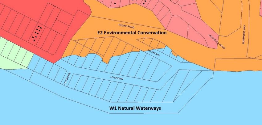
226.2 Amenity The amenity of the beach and foreshore is low. As much of the area has no owner presence or use, it is not routinely maintained and contains large and small items of rubbish and weed & grass infestation. Developed parts of the back beach comprise partially built sheds, stored tents, caravans and vehicles. The overall appearance is an unkempt and visually unattractive landscape. 7. COASTAL MANAGEMENT STRATEGY The primary objective of this plan is to ensure that future management of the Wharf Road east precinct is compatible with its current and future hazard levels. The hazard assessments undertaken by past studies have identified that the Wharf Road east precinct is a high-hazard zone due to the effects of both coastal inundation and periodic shoreline erosion. In the absence of feasible measures to mitigate these hazards, it is not considered a suitable location for future land development. The priority coastal management issues for the Wharf Road coastline discussed in proceeding sections of the CZMP are summarised with the corresponding adopted management actions. The strategy for managing the Wharf Road East study area is split into two sections - actions that have been completed or in progress, and those actions proposed for the future. A timeframe for implementation of the latter is proposed in this plan. 7.1 Completed Actions Environmental Planning - restrictive zonings Rezoning of private lands within the study area was recommended by WMA and has been acted upon by Council. This approach is in keeping with the NSW Coastal Policy goals and objectives. Accordingly the non-submerged land has been zoned E2 Environmental Conservation under the Eurobodalla Local Environmental Plan (LEP) 2012. All submerged lands have been Zoned W1 Natural Waterways. Relevant objectives of this zone are to identify sensitive coastal lakes, estuaries, wetlands, overland flow paths and riparian zones and those areas at risk from coastline hazards, including sea level rise; and to protect and enhance the natural environment for recreation purposes (See Appendices 1, 2). This action allows for the Wharf Road east precinct shoreline and backshore zone to naturally accommodate the coastal inundation and erosion that it is likely to experience in the future. 23
Fi gu r e 8 : Eu r o b o d al l a L o ca l En vir o n m en t a l P l a n 20 1 2 – L an d u se Zo n in g
Emergency Action Sub-plan
An Emergency Action Sub-plan for the Wharf Road Coastal Erosion ‘Hot Spot’ (Umwelt
(Aust) Pty. Ltd. 2012) was adopted by Council on 24 July 2012. It will form a sub-plan of this
CZMP.
The assets that are in the immediate inundation and erosion hazard zones at Wharf Road
east include:
informal beach access;
a small area of mainly she-oak vegetation;
an existing low rock revetment fronting the bend in Wharf Road;
a short rock groyne;
private properties; and
Council infrastructure (roads, sewerage gravity main and rising mains and
water supply trunk main).
Actions proposed under the Emergency Action Sub-plan are:
Pre-Storm Emergency - preparations such as stockpiling rock material; ensure
suitable plant and equipment on stand-by.
During Emergency - use of sand bags where appropriate to minimise erosion
and/or flooding; placement of additional rock material to stabilise the
shoreline and protect Council assets; if excessive overtopping of the rock
revetment results in the inundation of Wharf Road, Council should be prepared
with signage and/or safety barriers to close the road to traffic and pedestrians.
Post-Emergency - erect signage warning of hazards, or if public safety risks are
considered to be extreme, temporarily close access to this beach area; inspect
24the road, beach and rock revetments after damaging storm events and carry
out works to ensure area is safe.
7.2 Actions for Future Implementation
Beach ownership
The return of beaches to public ownership has long been a foundation of the coastal
management approach in NSW. There are currently 15 lots in the inter-tidal zone of the
estuary, some wholly under water and two 200m lengths of sandy beach under private
ownership. Public access to the beach at Wharf Road is a priority public issue.
Purchase of the back beach area lots is possibly of lower priority compared to many other
high hazard sites along the coast. Applications by Council to state agencies to purchase this
land in the past have been refused. The restrictive zoning adequately manages coastal risk
without the need for land acquisition.
However it is considered appropriate to incorporate in this plan a priority action to purchase
the private lands above High Water. This would return the areas of beach and the beach
access to public ownership.
In accordance with the judgment of Justice Bannon (ENVIRONMENT PROTECTION
AUTHORITY v. ERIC SAUNDERS [1994] NSWLEC 187(29 November 1994)), the lots identified
as submerged lands and those areas of beach below High Water are automatically vested in
the Crown and therefor acquisition of these lots is not required.
Public Infrastructure protection
Wharf Road and its extension into McLeod Street form one link from North Batemans Bay
and Surfside to the Princes Highway. The vulnerable point at the Wharf Road bend where it
is closest to the bay would preclude safe use by traffic during a moderate to severe ocean
storm with elevated tide levels. The road has been closed at this location in the past.
With this road closure in place, McLeod Street is the sole means of emergency egress to the
east for one caravan park at the corner of Wharf Road and McLeod Street.
Sewerage mains are located in the Wharf Road reserve at the location where Wharf Road is
closest to the bay foreshore (Figure 5). Two are pressure mains (rising mains) that service
residential development at the nearby village of Surfside. A sewer gravity main services
parts of North Batemans Bay. All are critical items of infrastructure with no alternative if
they were to fail.
These infrastructure items would be subject to wave attack in severe ocean storms. The
existing seawall at this corner of Wharf Road was found to be at high risk of failure due to
erosion, overtopping and undersize armour (WBM 2008). It is inadequate for complete
protection to a severe 1% storm and will be increasingly liable to damage as SLR progresses.
The Council water main is a 250mm pressure main that feeds the village of Surfside. There
are alternative supplies to Surfside such that this main could be isolated if it failed.
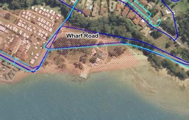
25Nonetheless it is in a vulnerable location and could damage the adjacent sewer mains if it was ruptured. Fi gu r e 9 : Co u n ci l in fr a st r u ctu r e in stu d y ar ea Any reconstruction of the seawall would need to tie into the existing wall in front of the Big 4 Tourist Park. A length overall of 100m of new seawall would be required at a cost estimated at $250,000. Maintenance after severe storms would require additional ongoing funding. Impacts of the seawall such as a temporary loss of sand after ocean storms should be considered in full. Investigations by Council’s Eurowater group are required into options for the relocation or improved protection of these assets. This issue will be picked up across the whole of the Shire in Council’s forthcoming CZMP. Actions for this area should be prioritised against other at-risk infrastructure which will be finalised in that plan. Weeds, rubbish clean-up and access improvements Access to the Public reserve should be improved to a safe standard. Regeneration of land areas and clean up by volunteers would be a positive community engagement activity to reinforce and promote eventual public ownership of the adjoining site. These actions are currently on public land and can be implemented independent of the outcome of the purchase of some or all of the lots in this area as discussed above. 26
7.3 Actions Implementation Summary
Table 5 presents a summary of actions and responsibilities under this plan.
Tab le 5 Act io n s Im p lem en tat ion Su m m ar y
Action Responsibility Timeframe Cost Status
1. Apply for the purchase of ESC with Application Unknown, Past requests
private properties at agency within 2 dependant on to agencies
Wharf Road that are support months of number of lots. have not been
above High Water to CZMP supported.
assure current and future adoption Offer will be
generations have public determined by
access to the foreshore Valuer
and beaches. General’s
assessment
2. Investigate options for the ESC End 2018 Nil Commence
relocation or improved (Eurowater) (in house upon Gazettal
protection of water and Investigations)
sewer mains at Wharf
Road and prioritise
against other
infrastructure in the shire.
3. Access improvements, ESC with local End 2018 Nominally Commence
weed and rubbish control Landcare $5,000 plus upon Gazettal
on public land adjacent to volunteer
Wharf Road contribution
4. Upon successful ESC with Application 50,000 Commence
implementation of Action agency within 2 upon Gazettal
(1) above: support months of
CZMP
Site remediation adoption
and clean-up
5. Incorporate incomplete ESC End 2018 Nil Investigations
actions into the underway and
Eurobodalla Coastal report in
Management Program preparation.
when finalised.
6. Review CZMP or ESC 31 Dec Nil additional -
incorporate into broader 2021 budget
Eurobodalla Coastal
Management Program in
accordance with
legislation.
Relevant actions are detailed on Figure 10 overleaf.
278. MONITORING AND REVIEW This plan will be monitored and reviewed before 31 December 2021 in accordance with the intended provisions of Schedule 3, Part 2(6(4)) of the Coastal Management Act 2016. Where appropriate and achievable, any outstanding actions will be incorporated into the Eurobodalla Coastal Management Program prior to this date. 28
Fi gu r e 1 0   Act io n P lan Su m m ar y - Wh ar f R oad CZM P

29
9. REFERENCES

BMT WBM, 2008. Wharf Road Coastal Hazard Assessment and Hazard Management Plan.
Prepared for Eurobodalla Shire Council.

DECCW (OEH), 2010. Guidelines for preparing Coastal Zone Management Plans.
http://www.environment.nsw.gov.au/resources/coasts/101019GdlnsCZMPs.pdf

DLWC, 1996. Batemans Bay Vulnerability Study

NSW Government, 1979. Coastal Protection Act 1979 No 13.
http://www.legislation.nsw.gov.au/maintop/view/inforce/act+13+1979+cd+0+N.

NSW Government, 2010. Coastal Protection and Other Legislation Amendment Act 2010 No
78. http://www.legislation.nsw.gov.au/sessionalview/sessional/act/2010-78.pdf.

OEH, 2011. Coastal zone management guide note – Emergency action sub-plans.
http://www.environment.nsw.gov.au/resources/coasts/110631gdntemacsubs.pdf.

Patterson Britton & Partners, April 1992. Land at Cullendulla Creek, Surfside - Flooding,
Beach Stability and Drainage Issues

Public Works Department, 1989. Batemans Bay Inundation Study

SMEC, October 2010. Eurobodalla Shire Coastal Hazards Scoping Study. Prepared for
Eurobodalla Shire Council.

SMEC, June 2015. Brooms Head Lake Cakora CZMP Final Draft

Umwelt (Australia) Pty. Ltd., 2012 Emergency Action Sub-plan for the Wharf Road Coastal
Erosion ‘Hot Spot’ Batemans Bay, NSW

WBM Oceanics, 1999. Batemans Bay Estuary Processes Study. Prepared for Eurobodalla
Shire Council.

WBM Oceanics, 2004 Batemans Bay & Clyde River Estuary Management Study Final Report

Webb McKeown & Associates Pty Ltd, November 2001. Draft Batemans Bay Coastline
Hazard Management Plan prepared for Eurobodalla Shire Council (final version dated
September 2006)

Whitehead and Associates Environmental, 2014. South Coast Regional Sea Level Rise Policy
and Planning Framework. Report to Eurobodalla Shire Council and Shoalhaven City Council.

Water Research Laboratory, 2012. Coastal Zone Management Plan for Batemans Bay; WRL
Technical Report 2012/2013. Umwelt Australia Pty Ltd, Toronto NSW, Australia.

30
You can also read