Wyndham Planning Scheme Amendment C243 Public Acquisition Overlay - Tarneit and Sayers Road, Hoppers Crossing
←
→
Page content transcription
If your browser does not render page correctly, please read the page content below
Planning and Environment Act 1987

Panel Report

Wyndham Planning Scheme Amendment C243
Public Acquisition Overlay – Tarneit and Sayers Road, Hoppers
Crossing

20 May 2020

Planning and Environment Act 1987
Panel Report pursuant to section 25 of the Act
Wyndham Planning Scheme Amendment C243

Public Acquisition      Overlay – Tarneit and Sayers Road, Hoppers
Crossing
20 May 2020

Jenny Moles, Chair                               Gabby McMillan, Member

Greg Sharpley, Member
Wyndham Planning Scheme Amendment C243 Panel Report 20 May 2020
Contents
Page
1 Introduction..............................................................................................................1
1.1 The Amendment ...................................................................................................... 1
1.2 Background to Amendment .................................................................................... 5
1.3 Panel procedural issues ........................................................................................... 7
1.4 Summary of issues raised in submissions ............................................................... 9
1.5 The Panel’s approach ............................................................................................ 10
1.6 Limitations and assumptions................................................................................. 11
2 Policy and strategic justification .............................................................................. 12
2.1 Planning and Environment Act 1987 ..................................................................... 12
2.2 Planning policy framework .................................................................................... 13
2.3 Other primary legislation ...................................................................................... 17
2.4 Other strategic and policy documents .................................................................. 20
2.5 Other guidance documents ................................................................................... 24
2.6 Ministerial Directions and Practice Notes ............................................................. 24
2.7 Panel discussion and conclusion ........................................................................... 24
3 Traffic demands and road safety ............................................................................. 27
3.1 Existing road layout ............................................................................................... 27
3.2 Traffic demand ...................................................................................................... 29
3.3 Road design and safety ......................................................................................... 31
3.4 Conclusions on traffic demands, and road safety and design .............................. 39
4 Direct impacts for affected landowners ................................................................... 40
4.1 Evidence and submissions ..................................................................................... 40
4.1 Panel discussion .................................................................................................... 42
4.2 Conclusions and recommendations ...................................................................... 44
5 Balancing costs and benefits ................................................................................... 45
5.1 The context ............................................................................................................ 45
5.2 The arguments to be weighed .............................................................................. 46
5.3 Financial costs and impacts ................................................................................... 46
5.4 Deferring the Amendment .................................................................................... 48
5.5 Conclusions and recommendations ...................................................................... 49
Appendix A Submitters to the Amendment and Submitters’ Group for Hearing
Appendix B Document listWyndham Planning Scheme Amendment C243 Panel Report 20 May 2020
List of Tables
Page
Table 1 Addresses of properties affected by the PAO ......................................................... 2
Table 2 Predicted traffic flow by AECOM and current volumes in vpd ............................. 29
Table 3 Summary of objecting submissions and responses on design and road safety .... 32
List of Figures
Page
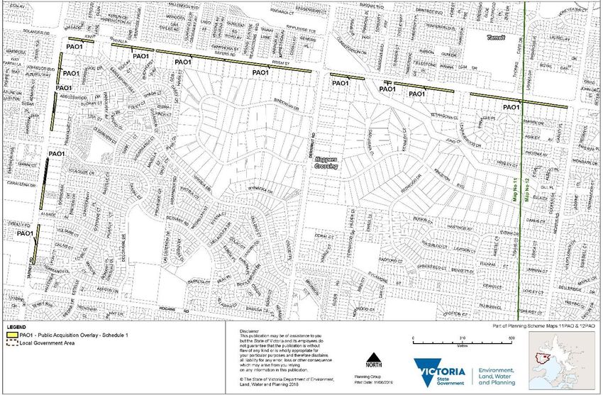
Figure 1 Application of proposed Public Acquisition Overlay
(Maps 11PAO and 12PAO)....................................................................................... 1Wyndham Planning Scheme Amendment C243 Panel Report 20 May 2020
Glossary and abbreviations
2012 Character Study Wyndham Neighbourhood Character Scoping Study 2012
Act Planning and Environment Act 1987
AECOM report Wyndham North Traffic Modelling and SIDRA Analysis, 31 May
2013, for Growth Areas Authority
Austroads – Part 5 Austroads Guide to Traffic Management (Part 5 – Road
Management)
Council Wyndham City Council
CWW City West Water
Cycling Strategy Victorian Cycling Strategy 2018-2028
DCP Development Contributions Plan
DDO Design and Development Overlay
DELWP Department of Environment, Land, Water and Planning
DOT Department of Transport
GRZ General Residential Zone
Kph Kilometres per hour
LAC Act Land Acquisition and Compensation Act 1986
LDRZ Low Density Residential Zone
LG Act Local Government Act 1989
LPPF Local Planning Policy Framework
MPS Municipal Planning Strategy
MSS Municipal Strategic Statement
NRZ Neighbourhood Residential Zone
OMR Outer Metropolitan Transport Corridor
PAO Public Acquisition Overlay
PE Act Planning and Environment Act 1987
planning scheme Wyndham Planning Scheme
PPF Planning Policy Framework
PPTN Principal Public Transport Network
PSP Precinct Structure Plan
PTV Public Transport VictoriaWyndham Planning Scheme Amendment C243 Panel Report 20 May 2020
Ratio 2014 report Traffic Engineering Assessment – Tarneit Road and Sayers Road,
Tarneit Vehicle Access Review, Ratio Consultants, 2014
RGZ Residential Growth Zone
SCC Strategic Cycling Corridor
TI Act Transport Integration Act 2010
VPA Victorian Planning Authority
Vpd Vehicles per day
WITS Wyndham Integrated Transport Strategy, June 2016Wyndham Planning Scheme Amendment C243 Panel Report 20 May 2020
Overview
Amendment summary
The Amendment Wyndham Planning Scheme Amendment C243
Common name Public Acquisition Overlay – Tarneit and Sayers Road, Hoppers
Crossing
Brief description The Amendment proposes to amend the Public Acquisition Overlay
(PAO) maps 11PAO and 12PAO to include land required for the
‘Tarneit and Sayers Roads service road’
Subject land The front 12 metres of:
• 72 properties on the south side of Sayers Road, between Tarneit
Road and Morris Road, Hoppers Crossing; and
• 25 properties on the east side of Tarneit Road, between Sayers
Road and Hogans Road, Hoppers Crossing
Planning Authority Wyndham City Council
Authorisation 4 July 2019 subject to condition (Note: following an administrative
update Amendment C162 was given the new Amendment number
C243)
Exhibition 25 July to 23 September 2019
Submissions Number of Submissions: 109 (87 from initial exhibition, further 22
late submissions)
Number of referral responses: 4: Department of Transport,
Powercor, Melbourne Water and City West Water
Complete list included as Appendix A
Panel process
The Panel Jenny Moles (Chair), Gabby McMillan and Greg Sharpley
Directions Hearing Planning Panels Victoria, 6 November 2019
Panel Hearing Wyndham Civic Centre, Werribee, 11, 12 and 28 February 2020
Site inspections Unaccompanied, 28 October 2019
Appearances Mr Terry Montebello of Maddocks instructed by Ms Diana Rice,
Principal Planner – Projects, Wyndham City Council, represented
Wyndham City Council and called the following expert witnesses:
• Mr Brett Young, Ratio on traffic engineering
• Mr Henry Turnbull, Traffix Group on traffic engineering
Mr Robert Forrester, barrister, instructed by Hall and Wilcox
represented a large group of property owners (as shown in
Appendix A) and called the following expert witness:Wyndham Planning Scheme Amendment C243 Panel Report 20 May 2020
• Mr John-Paul Maina – Impact Traffic Engineering Pty Ltd on
traffic engineering
Messrs Greg Johnson and Maurice Sims represented City West
Water
Mr Andrew Rasulo represented the Department of Transport
Citation Wyndham PSA C243 [2020] PPV
Date of this Report 20 May 2020Wyndham Planning Scheme Amendment C243 Panel Report 20 May 2020
Executive summary
Wyndham Planning Scheme Amendment C243 seeks to apply the Public Acquisition Overlay
(PAO) to the front 12 metres of 97 properties on Tarneit Road and Sayers Road in Hoppers
Crossing. The affected properties are principally used for low density residential purposes but
there are a few small scale commercial and community uses along the roadways.
The intended purpose of the PAO is to facilitate the future construction of service roads,
although the proposed PAO schedule does not mandate that the acquired land be used for
that purpose.
All but a few of the 109 submissions from affected landowners and related parties received in
response to exhibition of the Amendment, opposed the Amendment. A further four
submissions were received from government or servicing bodies - VicRoads (now Department
of Transport), Powercor, Melbourne Water and City West Water.
Key issues raised in opposing submissions included:
• Lack of strategic (policy) or technical engineering (demand and road safety)
justification for the Amendment, including a lack of analysis of alternative design
responses.
• Concerns about the compulsory acquisition process and compensation.
• Concerns about the concept design for the road, including the implications for the
extent of the PAO.
• Impacts on car parking, existing access arrangements, businesses, residential
amenity, services, existing septic tanks.
• Concerns about the future rezoning of existing Low Density Residential Zone land,
which might be facilitated by a service road.
The Panel appreciates the seriousness of this Amendment for the affected landowners who
face the possible compulsory acquisition of part of their properties.
The Panel conducted a Hearing over three days at which many of the affected landowners
were represented legally, as was the Council, and expert evidence was presented. The Panel
also made a lengthy inspection of the subject roads, adjoining parts of the road network as
well as the abutting properties and their hinterland.
In this Report, the Panel considers whether there is strategic policy support for the
Amendment, and whether there is empirical evidence concerning traffic demand, and road
safety and related issues, which would recommend that the service roads, which the
Amendment is designed to facilitate, should be constructed.
The Panel found that there is a lack of specific strategic road policy support for the
introduction of service roads along these stretches of arterial road. In particular, the upgrade
of the roads is not identified in the Council’s own policy documents nor does it accord with
Department of Transport priorities. Further, the Council’s adopted policy intents for
continuation of low intensity housing along these roads do not support the argument of
increasing local traffic demand. The empirical evidence about the need for the service roads
in terms of current and expected traffic conditions was not strongly made out.
Page i of iiWyndham Planning Scheme Amendment C243 Panel Report 20 May 2020
Nevertheless, the Panel concludes that:
• As a general matter of principle, it is appropriate to separate regional through
traffic from slow moving vehicles accessing individual land holdings.
• It is desirable from an efficiency and safety perspective to have sections of arterial
road treated in the same fashion as contiguous sections in terms of excluding
direct access to properties.
• There would be real amenity and urban design benefits of housing, bicycles and
pedestrians being separated from the through lanes of the arterial roadways by
wide planted medians and fronting a local street environment created by the
service road.
The Panel has weighed these benefits against asserted disbenefits to landowners and found
that, subject to further financial analysis, there is a net balance in favour of the Amendment.
As set out in the final chapter of the Report, the Panel has serious reservations about the
financial capacity of the Council to see through to implementation the service road project
which the Amendment is designed to facilitate.
The Panel recommends that this issue warrants further investigation by the Council before a
determination on whether to proceed with the Amendment is made.
Recommendation
The Panel recommends that:
Based on the reasons set out in this Report, the Wyndham Planning Scheme
Amendment C243 be adopted as exhibited but only after the further financial
analysis recommended in section 5.5 of this Panel Report is undertaken to
demonstrate that both the acquisition of land and the construction works are able
to be accommodated within the Council’s budgetary constraints.
Further recommendation
The Panel makes the following further recommendation:
The Council should consider committing to the implementation of the detailed
design components set out in section 3.3.1 (v) of this Panel Report as part of the
detailed design phase.
Page ii of iiWyndham Planning Scheme Amendment C243 Panel Report 20 May 2020
1 Introduction
1.1 The Amendment
(i) Amendment description
Amendment C243 (the Amendment) to the Wyndham Planning Scheme (planning scheme)
seeks to apply the Public Acquisition Overlay (PAO) to the front 12 metres of 97 properties on
Tarneit and Sayers Roads in Hoppers Crossing. The Explanatory Report for the Amendment
indicates that the purpose of the PAO is to facilitate the construction of a future service road,
including pavement, verge, footpaths, nature strip and underground services.
The Amendment would apply PAO Schedule 1 (PAO1) to maps 11 and 12 in the planning
scheme as shown in Figure 1. The purpose of PAO1 is ‘acquisition by Council for road
purposes.’ The Council is the nominated acquiring authority.
Figure 1 Application of proposed Public Acquisition Overlay (Maps 11PAO and 12PAO)
Source: Wyndham Planning Scheme, Planning Scheme Maps 11PA0 & 12PA0, exhibited
(ii) Subject land
The Amendment affects the land shown in Table 1 being:
• 72 properties on the south side of Sayers Road, between Tarneit Road and Morris
Road.
• 25 properties on the east side of Tarneit Road, between Sayers Road and Hogans
Road.
Page 1 of 58Wyndham Planning Scheme Amendment C243 Panel Report 20 May 2020
Table 1 Addresses of properties affected by the PAO
Location Land / Area Affected Mapping Reference
Hoppers Crossing 387 – 423 Sayers Road 12PAO
Hoppers Crossing 423-471 Sayers Road 11PAO
489 – 537 Sayers Road
547 Sayers Road
569-591 Sayers Road
404 Derrimut Road (where this
has frontage to Sayers Road)
609 – 687 Sayers Road
693 – 743 Sayers Road
747 – 771 Sayers Road
785 – 797 Sayers Road
673 – 689 Tarneit Road
645 – 665 Tarneit Road
587 – 625 Tarneit Road
551 – 573 Tarneit Road
Source: Wyndham Planning Scheme Amendment C243 – Explanatory Report, Attachment 1
(iii) Description of the subject land and surrounds
Most of the affected properties are large residential lots, each having an area of around 4,000
square metres. These properties form part of what was originally the outer western edge of
the municipal urban area. The area now adjoins rapidly expanding urban areas further to the
west.
The properties are predominantly developed with single-storey dwellings with substantial
front setbacks. A small number of the affected properties have been developed for non-
residential uses, such as places of worship, childcare centres and medical centres. A small
number of others have been developed for medium-density residential purposes, such as
townhouses.
The interface between the subject land and adjoining residential areas varies. The affected
properties on the eastern part of Sayers Road, represent the northern extremity of a large
precinct of low density lots which continue to use septic tanks for effluent disposal. The
affected lots elsewhere, on Tarneit Road and the western section of Sayers Road, abut more
traditional residential areas which have existing services.
A number of State and local planning documents highlight the high level of expected urban
growth in Wyndham to the north and west of the Amendment area. These include Plan
Melbourne which predicts that Melbourne’s west will be the fastest growing metropolitan
Page 2 of 58Wyndham Planning Scheme Amendment C243 Panel Report 20 May 2020
region into the middle of the 21st century.1 Land has also been reserved to the north and west
of the Amendment area for a key transport corridor, the Outer Metropolitan Transport
corridor.
The West Growth Corridor Plan of 9 August 2012, which is a high level integrated land use and
transport plan, identifies the Amendment area as an existing urban area and identifies future
urban growth areas to the north and west of the Amendment area.
The Council submissions also referred to the high expected growth levels, referring for
example to the Riverdale Precinct Structure Plan area 1.6km west of Tarneit Road and other
developing Precinct Structure Plan (PSP) areas in Wyndham North - Oakbank, Tarneit North,
and Truganina. The Council submission also referenced other PSPs with an associated
Development Contributions Plan (DCP) in Wyndham West located west and south-west of the
Riverdale PSP.
(iv) Description of the subject roads and surrounding road network
The affected properties currently have direct vehicular access from Sayers Road and Tarneit
Road.
Sayers Road and Tarneit Road are main roads servicing the wider Tarneit area. Sayers Road
runs in an east-west direction between Shanahans Road in Mount Cottrell and continues as
the Old Geelong Road in Laverton North. Tarneit Road runs in a north-south direction
between Boundary Road in Truganina and Railway Avenue in Werribee.
Both roads currently have 70km/h speed limits (except for Sayers Road east of Derrimut Road
which has a speed limit of 60km/h) and form part of the local cycle network. Sayers Road is
also on the Principal Public Transport Network (PPTN)2.
A more detailed description of the roads and the wider network is set out in section 3.1 of this
Report.
(v) Existing zoning and overlay controls
The subject land is mainly within two zones of the planning scheme. The properties located
between 727 - 797 Sayers Road are in the General Residential Zone – Schedule 1 (GRZ1). The
properties located between 381 - 723 Sayers Road are in the Low Density Residential Zone
(LDRZ).
The purposes of GRZ1 include:
• To implement the Municipal Planning Strategy and the Planning Policy Framework.
• To encourage development that respects the neighbourhood character of the area.
• To encourage a diversity of housing types and housing growth particularly in
locations offering good access to services and transport.
The purposes of the LDRZ are:
• To implement the Municipal Planning Strategy and the Planning Policy Framework.
• To provide for low-density residential development on lots which, in the absence of
reticulated sewerage, can treat and retain all waste water.
1 Plan Melbourne, page 45
2 Shown in West Corridor Growth Plan
Page 3 of 58Wyndham Planning Scheme Amendment C243 Panel Report 20 May 2020
One small part of the subject land, an existing reserve on Sayers Road to the east of Derrimut
Road, is zoned Urban Floodway Zone (UFZ).
Small sections of the subject land are affected by existing overlay controls:
• PAO2 applies to the land on the corner of Sayers Road and Derrimut Road. The
purpose of PAO2 is for ‘acquisition by Vic Roads for road purposes.’
• Special Building Overlay (SBO) applies to a couple of properties fronting Sayers
Road (overlapping in part with land zoned UFZ).
For most of the subject land, therefore, the use or development of land as a road does not
require a planning permit.3
In the residential zones, the use and development of a lot for a single dwelling, including works
normal to a dwelling, generally does not require planning permission. Smaller medical centres
also may not require planning permission. Childcare facilities require a permit.
The road reserve on Tarneit Road and Sayers Road west of Derrimut Road are both zoned
Road Zone 2. The road reserve on Sayers Road east of Derrimut Road is zoned Road Zone 1.
Clause 52.29 imposes the need for planning permission to create or alter access to a Road
Zone 1.
(vi) Statutory effect of application of the PAO
Clause 45.01-1 of the planning scheme sets out the permissions required if a PAO is in place.
Most relevantly the clause includes:
A permit is required to:
• Use land for any Section 14 or Section 2 use in the zone.
• Construct a building or construct or carry out works, including:
- A domestic swimming pool or spa and associated mechanical and safety
equipment if associated with one dwelling on a lot
- A pergola or verandah, including an open-sided pergola or verandah to a
dwelling with a finished floor level and a maximum building height of 3 metres
above ground level.
- A deck to a dwelling with a finished floor level not more than 800mm above
ground level.
…
• Subdivide land.
…
Clause 52.29 would continue to apply to the properties along Sayers Road east of Derrimut
Road, as permission is required to alter access to PAO land where it is for the purpose of a
Road Zone 1.5
With the PAO in place, the provisions of section 98 of the Planning and Environment Act 1987
(PE Act) and the Land Acquisition and Compensation Act 1986 (LAC Act) would be triggered.
3 Permission is not required under the GRZ1 or LDRZ given the provisions of clause 62.01. In the UFZ and SBO, a permit is
required only if the water flow path is redirected or obstructed
4 A use not requiring a permit under the zone such as a single dwelling on a lot
5 It is unclear whether the PAO should be regarded as for the purpose of a Road Zone 1 but we have assumed that is the
case
Page 4 of 58Wyndham Planning Scheme Amendment C243 Panel Report 20 May 2020
Clause 45.01-6 of the planning scheme provides that:
Any land included in a Public Acquisition Overlay is reserved for a public purpose within
the meaning of the Planning and Environment Act 1987, the Land Acquisition and
Compensation Act 1986 or any other Act.
Under section 98 of the PE Act an owner can claim compensation from the Council in the
following circumstances:
• As the ‘planning authority’ for financial loss suffered as a natural, direct and
reasonable consequence of the land being reserved for a public purpose.
• As the ‘responsible authority’ for financial loss suffered as a natural, direct and
reasonable consequence of a refusal by the Council to grant a permit to use or
develop land on the basis that the land is (or will be) needed for a public purpose.
The LAC Act sets out the procedure for the compulsory acquisition of land. Section 31 of the
LAC Act sets out the matters which must be taken into account when assessing an offer of
compensation:
• The market value of the land.
• Any special value due to the location of the land.
• Loss attributable to severance.
• Loss attributable to disturbance.
• Legal, valuation and professional expenses.
• Solatium (e.g. to compensate for intangible disadvantages).
1.2 Background to Amendment
This Amendment was preceded by earlier planning scheme amendments and other strategic
work affecting the subject area. This previous work considered vehicle access arrangements
from Sayers Road and Tarneit Road and the zoning of the area more generally.
The following is a chronology of relevant studies and decisions of the Council:
• 2012 – The Council adopted the Wyndham Neighbourhood Character Scoping
Study (2012) (2012 Character Study). The 2012 Character Study recommended
further investigation of the Amendment Area, on the basis that the spacious
landscape character could be threatened by future subdivision and development.
This study recommended further strategic work to integrate neighbourhood
character studies with housing studies.
• 2013 – The Council adopted the Tarneit and Sayers Road Neighbourhood
Character Investigation Report (2013) (2013 Precinct Study). The 2013 Precinct
Study only related to part of the subject land, being the GRZ land on Tarneit Road
and Sayers Road between Tarneit Road and the LDRZ. Notably, the 2012 Character
Study recommended a municipal wide character study, however Council brought
this precinct forward ‘due to a rise in the number of applications for planning
permits in the precinct proposing high density residential development’.6
• 2012-2013 – Amendments C185 and C204 were prepared for part of the subject
land (the GRZ land on Tarneit and Sayers Road). The purpose of the amendments
were as follows:
6 Explanatory report for Amendment C185 for the Wyndham Planning Scheme
Page 5 of 58Wyndham Planning Scheme Amendment C243 Panel Report 20 May 2020
- Amendment C185 was prepared to apply a Design and Development Overlay
(DDO) Schedule 9 (DDO9) on a permanent basis.
- Amendment C204 was prepared to apply a Development Contributions Plan
Overlay (DCPO) and Development Contributions Plan to collect financial
contributions from development towards the construction of a service road.
• 2013 – Amendment C184 was approved in October 2013 via section 20(4) of the
PE Act. It applied an interim DDO9 to the GRZ land on Tarneit Road and Sayers
Road. DDO9 required a minimum building setback of 20 metres to ensure
adequate space for a future service road.
• 2013-2015 – Amendments C185 and C204 were each exhibited7 and submissions
were received. The Council resolved on 23 March 2015 to refer these
amendments to a Panel concurrently for consideration. At the Directions Hearing
in May 2015, the Council advised the Panel that late submissions had been
received and Council decided to defer the Panel proceedings, to further exhibit
the amendments in response to the late submissions. Subsequently, additional
late submissions were received.
• 2014 – The Council commissioned Ratio to prepare Traffic Engineering Assessment
– Tarneit Road and Sayers Road, Tarneit Vehicle Access Review 2014 (Ratio 2014
report). The report concluded that the use of service roads to be the appropriate
road access management strategy for the redevelopment expected along GRZ land
on Tarneit Road (east side) and Sayers Road (south side).
• 2015 – The Council resolved to abandon Amendments C185 and C204 (contrary to
officer recommendations) in August 2015.
• 2015 – The Council adopted its Housing and Neighbourhood Character Strategy
September 2015 in August 2015. When the Council adopted it, it also resolved
that ‘should planning scheme Amendments C185 or C204 not proceed, instruct
Council Officers to amend the adopted Housing and Neighbourhood Character
Strategy to show the Tarneit and Sayers Road Precinct as Limited Incremental
Change in recognition of the infrastructure constraints associated with the area.’8
• 2015 – The outcomes of the 2012 Character Study were incorporated into the
planning scheme as part of the Municipal Strategic Statement (MSS) review (via
Amendment C192). Clauses 21.07-3 and 22.04 of the planning scheme identify
the preferred character the subject land as predominantly Garden Court or Bush
Garden.
• 2016 – The interim DDO9 expired in June 2016.
• 2016 – The Wyndham Integrated Transport Strategy (WITS) and Wyndham
Integrated Transport Policy (Wyndham Transport Policy) were adopted by Council
at its meeting on 27 June 2016.
• 2017 – In February 2017, the Council resolved to seek authorisation from the
Minister for Planning to prepare the present Amendment.
• 2018 – A revised Wyndham Housing and Neighbourhood Character Strategy 2018
(2018 Housing Strategy) was adopted by Council on 7 August 2018. The land
7 Amendment C185 exhibited 29 August – 4 October 2013 and 8 submissions were received. Amendment C204 was
exhibited 27 November 2014 – 12 January 2015 and 3 submissions were received
8 Wyndham City Council meeting minutes 24 August 2015
Page 6 of 58Wyndham Planning Scheme Amendment C243 Panel Report 20 May 2020
fronting Tarneit and Sayers Roads is identified in the strategy as an area of Limited
Change.9 At that same meeting the Council resolved to seek authorisation and
prepare Amendment C161 to implement the recommendations of the 2018
Housing Strategy. The Council sought authorisation in September 2018, however
the amendment has not yet been authorised.
1.3 Panel procedural issues
1.3.1 Adjournment request
On 29 October 2019, Hall and Wilcox requested an adjournment of the Hearing on behalf of a
submitters’ group – principally owners of land affected by the proposed PAO. The reasons for
the request were that Hall and Wilcox would not be available to appear at the expected time
for the Hearing and the submitters required more time to prepare and raise the required funds
to engage an expert witness.
On 4 November 2019, Maddocks on behalf of the Council opposed the request.
At the Directions Hearing, the Panel heard from the submitters’ group and the Council with
regard to the request. The Council raised concerns about timing. It wanted to ensure there
was adequate time for the matter to be concluded before the caretaker period for local
government elections in September 2020. It was also asserted that road safety issues dictated
that the Amendment proceed promptly.
The Panel granted the adjournment request on the basis that the application of a PAO was a
matter with serious consequences for the submitters and the adjournment would provide
submitters with enough time to better prepare for the Hearing. The Panel considered that
there was adequate time for the matter to be concluded by the Council before the caretaker
period. No evidence of immediate or significant road safety issues, alleged by the Council,
was provided to suggest that a more urgent Hearing was needed.
1.3.2 Additional submitters
At the Directions Hearing, Hall and Wilcox sought to add 10 late submitters to the list of
persons already represented by that firm. The Council did not object to the late submissions,
provided that the submitters did not raise substantial new grounds.
Copies of 12 late submissions received by Council were provided to the Panel on 28 November
2019.
On 9 December 2019 Council provided the Panel with an updated index and complete set of
submissions (including the late submissions) for use during the Hearing.
1.3.3 Additional information sought by Panel prior to the Hearing
The Panel requested additional information from City West Water (CWW) and the
Department of Transport (DOT) prior to the Hearing. The Panel asked both authorities to
attend the Hearing.
9 Allows for minimal housing change due to the environmental, heritage and neighbourhood character of the area, or other
significant development constraints. Future housing will predominantly comprise single dwellings with some dual
occupancy development.
Page 7 of 58Wyndham Planning Scheme Amendment C243 Panel Report 20 May 2020
CWW was asked to respond to the following:
• Are there any potential timing issues relating to sewering of affected lots?
• Would a wider sewerage scheme for the area be an outcome of the requirement
to sewer some lots affected by the proposed service road?
DOT was asked to respond to the following:
• Sayers Road is a declared VicRoads arterial road east of Derrimut Road and a
Council-managed main road west of Derrimut Road. Tarneit Road is a Council-
managed main road. What will be the future designations of these roads?
• When will the single lane section of Sayers Road to the east be upgraded?
• Who will be paying for the service road works?
• Has VicRoads reviewed the service road designs that are the subject of the
Amendment and approved them? The VicRoads referral response of 23
September 2019 suggests detailed design is yet to be considered.
• What is the VicRoads’ response to the detailed traffic and risk issues raised in the
submission by Mr Hood (attached)? Risks for all types of road users not just
private vehicles should be addressed.
• Does the VicRoads’ view in its letter of 23 September 2019 represent a DOT10 view,
including Public Transport Victoria (PTV)? There is some reference to DOT in the
referral response letter.
• The VicRoads’ letter to the Council of 17 June 2019 and the VicRoads’ referral
response of 23 September 2019 are essentially the same except for the
penultimate paragraph. Could the reason for the changed paragraph and the
meaning of the revised version be clarified?
• Could PTV advise on the effects of the proposed service roads upon the safety and
efficiency of bus operations?
These matters were addressed in the CWW and DOT submissions at the Hearing and where
relevant are discussed in the Panel’s assessment below.
1.3.4 Additional information sought after the Hearing
At the end of the Hearing, the Panel directed the Council to provide further advice on the road
priorities identified in the WITS and any updated priority plans. Other parties were then given
the opportunity to respond.
On 11 March 2020, the Council provided further information about road priorities and made
some further comments in relation to budget priorities.
On 18 March 2020, Hall and Wilcox provided a further response to the Council’s letter on
behalf of the submitters’ group. On 24 March 2020, DOT provided a response.
This matter is referred to in the Panel discussions later in this Report.
10 VicRoads and Public Transport Victoria were amalgamated into the Department of Transport (DOT) in mid-2019. From 1
January 2020, DOT superseded VicRoads as a referral authority under the planning scheme.
Page 8 of 58Wyndham Planning Scheme Amendment C243 Panel Report 20 May 2020
1.4 Summary of issues raised in submissions
The majority of the 109 submissions received by the Council from affected landowners and
related parties opposed the Amendment. A further four submissions were received from
government or private servicing bodies - VicRoads (now DOT), Powercor, Melbourne Water
and CWW.
Many of the submissions from affected landowners and related parties were based on a
proforma letter, with additional content added to address individual concerns.
(i) Landowner submissions
The issues raised in written submissions and at the Hearing by the submitters’ group barrister
can be summarised as follows:
• Lack of strategic (policy) or technical engineering (demand and road safety)
justification for the Amendment, including a lack of analysis of alternative design
responses.
• Oppose the application of the PAO on private land.
• Concerns about the compulsory acquisition process and compensation.
• Concerns about the concept design for the road, including the implications for the
extent of the PAO.
• Impacts on car parking, existing access arrangements, businesses, residential
amenity, services, existing septic tanks.
• Concerns about the future rezoning of existing LDRZ land, which might be
facilitated by a service road.
• Applying the PAO would divert financial resources away from the Council’s
transport infrastructure priorities, as a result of inevitable compensation claims
and the cost of installing the road and associated alterations to service
infrastructure.
(ii) Planning Authority
The key issues for the Council were:
• Strategic justification for the Amendment.
• Public acquisition and compensation matters.
• Impacts on individual properties.
• Balancing costs and benefits of the Amendment.
(iii) Relevant agencies (DOT and CWW)
The key issues for DOT were:
• Integration of the service road with the wider transport network (including
implications for private vehicles, cyclists and public transport).
• Demand and timing.
The key issues for CWW were:
• Effects on servicing arrangements, including sewer and water supply.
Page 9 of 58Wyndham Planning Scheme Amendment C243 Panel Report 20 May 2020
1.5 The Panel’s approach
The Panel has considered all written submissions made in response to the exhibition of the
Amendment, together with submissions, evidence and other material presented to it during
the Hearing, and as forwarded afterwards in response to the Panel Direction. The Panel‘s
consideration of the issues has been informed by its site visit. All submissions and materials
have been considered by the Panel in reaching its conclusions, regardless of whether they are
specifically mentioned in the Report. Reference has been made in the Report only to the more
relevant or determinative material.
The Panel has assessed the Amendment against the principles of net community benefit and
sustainable development, as set out in Clause 71.02-3 (Integrated decision making) of the
planning scheme.
The Panel is conscious that the acquisition of land is a significant matter for the landowners
directly affected. The nature of the Amendment has influenced the Panel’s approach. The
Panel generally agrees with the sentiment of other Panels that have considered the
introduction of a PAO.
In Amendment C56 to the Mildura Planning Scheme which related to acquisition of land for
regional sporting facilities, the Panel said:
In considering this Amendment, the Panel has been conscious that it is a very significant
matter for the landowners whose land is intended to be acquired. It is a serious matter
for anyone to be told by government that their land is needed for some public purpose
and that the government, whether it be Federal, State or local, intends to acquire it
compulsorily and they must relinquish that land ‐ whether or not they wish to do so.
The seriousness of the matter is reflected by the fact that land ownership and
compulsory acquisition are matters addressed in this State as part of the human rights
legislation. Section 20 of the Charter of Human Rights and Responsibilities Act 2006
requires that ‘A person must not be deprived of his or her property other than in
accordance with the law’.
The Panel’s awareness of the seriousness of this matter was raised by the Panel Chair
at the Directions Hearing. The nature of this issue means an independent Panel review
is perhaps more critical than in the case of most other amendments.
In the Panel’s view, it is generally the case that whenever a planning authority is
proposing to acquire land compulsorily there needs to be a high level of strategic
justification and a significant public benefit must be demonstrated.
[Emphasis added]
In considering Amendment C197 to the Stonnington Planning Scheme which proposed PAOs
for the creation of public open space, the Panel said:
The Panel commends Council for actively pursuing these opportunities, particularly
where, as in the present circumstances, difficult decisions are required to be made in
pursuit of longer term planning goals. The Panel agrees with Council’s submission that
‘it is in the interests of good and proper planning that such proposals be identified as
early as possible …’
However in circumstances such as this Amendment, where the consequences are not
just the partial acquisition of a property but the dislocation of residents from their homes,
any alleged public benefits will inevitably be brought into much sharper focus, as they
perhaps should be. In these circumstances it is incumbent upon a planning authority to
clearly articulate these public benefits and submit them to public scrutiny.
Page 10 of 58Wyndham Planning Scheme Amendment C243 Panel Report 20 May 2020
On the other side of the equation the consequences for the landowners are perhaps
much clearer and more stark. Irrespective of the final outcome of the Master Plan
review, the landowners will live with the prospect that their homes may at any time be
acquired. Even if compulsory acquisition does not occur immediately, as was
suggested by Council, the PAO will still potentially affect their ability to improve (ie.
develop) and fully enjoy their residences as other people are able to do. The Panel
notes that it is not the wish of Council or the sporting clubs for the properties to
be compulsorily acquired and Council has acknowledged that it may be some
time before a property is actually acquired.
The Panel does not necessarily consider it to be in the public interest, nor
consistent with the purpose of the PAO, to impose reservations on private land
where the need for the land is uncertain and where its acquisition may not
ultimately occur for a long period of time.
[Emphasis added]
Having regard to Clause 71.02-3 (Integrated decision making) of the planning scheme and the
nature of the Amendment, the Panel considers that a high level of strategic justification and
public benefit is required before a PAO is introduced onto private land. The Panel needs to
weigh up the costs and benefits to determine whether there is a net community benefit. The
private losses to individual landowners need to be offset against any public benefit.
This Report considers the Amendment and submissions under the following headings:
• Policy and strategic justification
• Traffic demands and road safety
• Direct impacts for affected landowners
• Balancing costs and benefits.
1.6 Limitations and assumptions
The Panel has assessed the Amendment on the basis that the PAO will facilitate a service road,
which may be 20 years away. The Panel notes that the PAO in no way mandates this particular
use of the acquired land, in fact the purpose of PAO1 is quite broad and allows ‘acquisition by
Council for road purposes.’ In terms of the purpose of the PAO provided in the planning
scheme, therefore, the PAO land might be used by the Council to acquire land for more
through traffic lanes or for a dedicated bike lane.
The Panel’s balancing of costs and benefits has, however, assumed the use of the PAO area
for service roads, given the content of the Explanatory Report and the Council’s submissions.
The balance may have been different if the material had indicated that the PAO was designed
to facilitate a different type of transport project.
The Panel has also assumed that the Council, as the acquiring authority, would meet the costs
of acquisition and ultimately the costs of constructing the road (including the associated costs
of relocating services and other associated costs). The Panel has assumed that a DCP, as was
earlier proposed along these roads, will not be applied in the future to fund either the
acquisition or construction costs.
The Panel has not specifically addressed the devaluation of properties affected by the
Amendment. Property values is a consideration which is outside the scope of the PE Act. Such
matters would be dealt with under the LAC Act if the PAO was applied to the Amendment
area.
Page 11 of 58Wyndham Planning Scheme Amendment C243 Panel Report 20 May 2020
2 Policy and strategic justification
In this chapter, the Panel examines what strategic support can be found for the proposed
Amendment in the broader policy context and strategic planning documents.
2.1 Planning and Environment Act 1987
2.1.1 Objectives
The objectives of planning in Victoria as set out in section 4 of the PE Act relevantly include:
(a) to provide for the fair, orderly, economic and sustainable use, and development
of land;
…
(c) to secure a pleasant, efficient and safe working, living and recreational
environment for all Victorians and visitors to Victoria;
…
(e) to protect public utilities and other assets and enable the orderly provision and
co-ordination of public utilities and other facilities for the benefit of the
community;
(f) to facilitate development in accordance with the objectives set out in paragraphs
(a) … (c), … and (e);
(g) to balance the present and future interests of all Victorians.
2.1.2 Submissions and background material
The exhibited Explanatory Report for the Amendment referred to the objectives of section 4
the Act. It said that the Amendment implements these objectives by facilitating a service road
which will allow safe access onto arterial roads, and will result in improved road connections
and reduced congestion and improved road safety for all road users. The Explanatory Report
also stated that the siting of the service road will avoid disruption to existing essential services
for abutting properties, though the submissions at the Panel Hearing by CWW and the
submitter’s group cast some doubt on this claim. It was also said that the road would cater
for future demand by the growing community.
The Council’s Part A submission adopted the strategic assessment from the Explanatory
Report. While a further outline of planning policy and other strategic documents was
provided, the objectives of the Act were not re-addressed explicitly.
Mr Forrester’s submissions for the submitters’ group did not refer to the Explanatory Report
and this commentary by the planning authority, but did comment adversely on the Council’s
Part A strategic assessment generally. Mr Forrester observed that it was really only a ‘tick the
box’ exercise asserting consistency on the assumption that the Amendment would result in
improvements to the transport network.
2.1.3 Panel comment
The broad objectives of the PE Act support the orderly provision of facilities for the community
now and in the future, and the achievement of living environments which are, amongst other
things, efficient and safe. Importantly the Act seeks to ensure that the use and development
Page 12 of 58Wyndham Planning Scheme Amendment C243 Panel Report 20 May 2020
of land is also achieved fairly. These broad planning objectives are unassailable and each
planning decision should seek to optimise and achieve an appropriate balance of the
objectives.
The broad considerations of the Act are given more explicit expression in some of the policies
of the planning scheme which are set out below. These policies enable a better understanding
of whether the objectives of the Act will be met by the proposal.
2.2 Planning policy framework
2.2.1 State planning objectives
Clause 11.02-1S (Supply of urban land) of the planning scheme includes the following
strategies:
Ensure the ongoing provision of land and supporting infrastructure to support
sustainable urban development.
Planning for urban growth should consider:
▪ Opportunities for the consolidation, redevelopment and intensification of existing
urban areas.
▪ Neighbourhood character and landscape considerations.
▪ The limits of land capability and natural hazards and environmental quality.
▪ Service limitations and the costs of providing infrastructure.
Clause 15.01-1S (Urban design) includes the following strategies:
Ensure development supports public realm amenity and safe access to walking and
cycling environments and public transport.
Ensure that development, including signs, minimises detrimental impacts on amenity,
on the natural and built environment and on the safety and efficiency of roads.
Promote good urban design along and abutting transport corridors.
Clause 15.01-4S (Healthy neighbourhoods) includes the following strategy:
Design neighbourhoods that foster community interaction and make it easy for people
of all ages and abilities to live healthy lifestyles and engage in regular physical activity
...
Clause 15.02-1S (Energy and resource efficiency) including the following strategy:
Promote consolidation of urban development and integration of land use and transport.
Support low energy forms of transport such as walking and cycling.
Clause 18 (Transport) provides:
Planning should ensure an integrated and sustainable transport system that provides
access to social and economic opportunities, facilitates economic prosperity,
contributes to environmental sustainability, coordinates reliable movements of people
and goods, and is safe.
Clause 18.01-1S (Land use and transport planning) includes the strategy to:
Plan urban development to make jobs and services more accessible by:
Page 13 of 58Wyndham Planning Scheme Amendment C243 Panel Report 20 May 2020
▪ Ensuring equitable access is provided to developments in accordance with
forecast demand, taking advantage of all available modes of transport and to
minimise adverse impacts on existing transport networks and the amenity of
surrounding areas.
▪ Coordinating improvements to public transport, walking and cycling networks
with the ongoing development and redevelopment of urban areas ...
Clause 18.01-2S (Transport system) includes the following strategies:
Reserve land for strategic transport infrastructure.
Incorporate the provision of public transport, cycling and walking infrastructure in all
major new state and local government road projects.
Locate transport routes to achieve the greatest overall benefit to the community to
making the best use of existing social, cultural and economic infrastructure, minimising
impacts on the environment and optimising accessibility, safety, emergency access,
service and amenity.
Clause 18.02-3S (Road system) seeks:
To manage the road system to achieve integration, choice and balance by developing
an efficient and safe network and making the most of existing infrastructure.
The strategies to achieve that objective include:
Plan and regulate the design of transport routes and nearby areas to achieve visual
standards appropriate to the importance of the route with particular reference to
landscaping, the control of outdoor advertising and, where appropriate, the provision of
buffer zones and resting places.
...
Make better use of roads for all road users through the provision of wider footpaths,
bicycle lanes, transit lanes (for buses and taxis) and specific freight routes.
Selectively expand and upgrade the road network to provide for:
▪ High-quality connections between Metropolitan Melbourne and regional cities,
and between regional cities.
▪ Upgrading of key freight routes.
▪ Ongoing development in outer suburban areas.
▪ Higher standards of on-road public transport.
▪ Improved key cross-town arterial links in the outer suburbs including
circumferential and radial movement.
Clause 19 (Infrastructure) seeks:
To provide timely, efficient and cost-effective development infrastructure that meets the
needs of the community.
It is strategy to:
Provide an integrated approach to the planning and engineering design of new
subdivision and development.
Page 14 of 58Wyndham Planning Scheme Amendment C243 Panel Report 20 May 2020
2.2.2 Local planning objectives
Clause 21 (Municipal Strategic Statement)
Clause 21.01-1 Municipal Profile identifies the demand for infrastructure as a key planning
issue. Specifically, it includes that the Council will need to invest at least $1.5 billion in
infrastructure to keep up with projected growth. Transport is another key planning issue, the
planning scheme recognising that road and rail transport infrastructure will face increasing
capacity constraints as demand increases.
Clause 21.09-1 (Integrated transport networks) has several objectives, including:
To improve and upgrade transport infrastructure to meet existing and future population.
To provide safe walking and cycling routes to connect people to destinations.
To provide for the safe, efficient and effective operation of public transport.
In that same clause, further strategic work is identified including:
Develop a transport network strategy to achieve an integrated strategy that addresses
short, medium and long-term transport needs.
Investigate appropriate strategies for freight handling facilities and transport corridors.
Develop local area traffic management schemes to reduce the impact of traffic speeds
and volumes.
Investigate the application of the Public Acquisition Overlay.
Clause 22.04 (Neighbourhood character) draws on work from the 2012 Character Study. It
identifies the parts of the Amendment area zoned GRZ1 as ‘Garden Court’ character type and
the parts zoned LDRZ as ‘Bush Garden’ or ‘Bush Suburban Garden’ character type.
In Garden Court areas, clause 22.04-3.1 requires proposals for residential development to be
assessed against the following criteria:
▪ Protection of existing tree canopy where well established.
▪ Provision for new canopy trees where lacking.
▪ Pattern of dwelling spacing of 1 to 2m from side boundaries.
▪ Low front fencing or open frontage with no fencing.
▪ Interface with open spaces and creek or river corridors.
In the Bush Suburban Garden areas, clause 22.04-3.4 sets out the following criteria:
▪ Protection of existing tree canopy which includes many native trees.
▪ Provision for new canopy trees where lacking.
▪ Native landscaping theme.
▪ Pattern of dwelling spacing of 4 to 8m from side boundaries.
▪ Open frontage with no fencing or rural style front fences.
▪ Rural road treatment.
▪ Interface with open spaces and creek or river corridors.
Page 15 of 58Wyndham Planning Scheme Amendment C243 Panel Report 20 May 2020
2.2.3 Submissions on planning policy
The Council submitted that there was strategic support for the PAO primarily on the basis of
increases in traffic demand (owing to intensification of development to the north and west)
and predicted road safety and efficiency benefits. The Explanatory Report and the
submissions for the Council also referred to the intensification of uses, particularly medium
density housing, along Sayers and Tarneit Roads. This, in combination with the anticipated
increases in regional traffic on those roads, was said to justify the construction of the service
roads.
The Council relied on State and local policy which identified the existing high demand on
infrastructure generally within the municipality. The Council also submitted that there would
be design and amenity benefits for affected landowners if a service road were constructed, as
they would experience a local road environment rather than have direct abuttal to an arterial
road. The Council relied on State policy at clause 15 in support of the latter.
The DOT referred to the West Growth Corridor Plan of 2012, as well as the Victorian Cycling
Strategy 2018-2028 (Cycling Strategy), the Austroads Guide to Traffic Management and the
VicRoads Guidance for Planning Road Networks in Growth Areas. The DOT relied primarily on
the general guidance that suggests that service roads are a preferable design response to
managing access onto arterial roads. The DOT did not, however, make any submissions that
suggested there was any immediate demand for a service road on Sayers Road or Tarneit
Road. The DOT submitted that it had not yet been determined whether Sayers Road or Tarneit
Road would be State arterial roads in the future (and therefore managed by DOT). DOT also
submitted that there was no funding available at State level for the service road project.
The submitters’ group was critical of the Council’s strategic assessment of the Amendment.
The group submitted that the Council was relying on generic policy objectives that call for
infrastructure to meet demand, rather than any empirical evidence that such a demand
existed for a service road in this location. The submitters’ group also criticised the lack of
empirical evidence about the stated road safety benefits. In this respect, the submissions
were critical of the evidence presented for the Council on traffic matters purporting to support
the Amendment. Further, the submissions were critical of the DOT submissions claiming that
it inappropriately relied upon the base statements by the witnesses for the Council and
generic material from Austroads publications. It was said that the DOT submissions amounted
to nothing more than in-principle support for service roads generally.
2.2.4 Panel comment
The broad policies relating to forward planning for regional infrastructure, enhanced amenity
of areas along main roads, encouragement of sustainable forms of transport such as cycling,
walking and public transport, and enhanced road safety, are broadly supportive of the
Amendment. The Panel agrees with the submissions on behalf of the submitters’ group,
however, that a more detailed examination of local policy and an empirical analysis of the
traffic arguments needs to be undertaken to establish whether the broad planning policy
objectives would be met by the application of the PAO and construction of the service roads
in this case, and whether the appropriate balance is struck against the disbenefits of the
project.
Page 16 of 58You can also read