Assessment of social effects of the Ohinewai Masterplan - for Ambury Properties Limited Robert Quigley Quigley and Watts Ltd.
←
→
Page content transcription
If your browser does not render page correctly, please read the page content below
Assessment of social effects of the
      Ohinewai Masterplan

        for Ambury Properties Limited

               Robert Quigley

           Quigley and Watts Ltd.

                     Final

                27 November 2019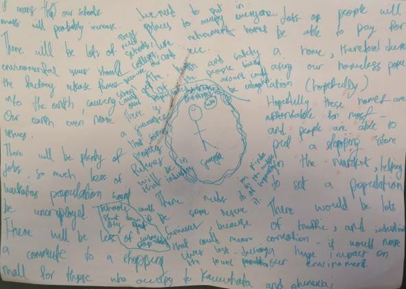
Document control

  Version of document   Date of revision   Prepared by      Reviewed by

  1 – first draft       16 October 2019    Robert Quigley   David Gaze, Gaze
                                                            Holdings Limited.
                                                            John Olliver, Bloxam
                                                            Burnett & Olliver
                                                            Limited.

  2 – second draft      22 November 2019   Robert Quigley   Sam Foster, Bloxam
                                                            Burnett & Olliver
                                                            Limited
  3 - final             27 November 2019   Robert Quigley

    •                                                                              2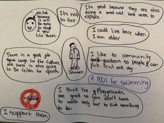
Table of Contents
Executive summary ................................................................................................................................... 5
1 Introduction ......................................................................................................................................... 10
   1.1 Purpose and objectives of the report .......................................................................................... 11
   1.2 The site........................................................................................................................................ 11
   1.2 The masterplan ............................................................................................................................. 11
    1.2.1 The primary tenant and approximate timing ............................................................................. 11
    1.2.2 Other industrial tenants ............................................................................................................. 12
    1.2.3 Retail and other businesses ...................................................................................................... 12
    1.2.4 Housing ..................................................................................................................................... 13
    1.2.5 Support services ....................................................................................................................... 13
    1.2.6 Recreation ................................................................................................................................. 13
    1.2.7 Connections to Huntly ............................................................................................................... 13
2. Approach and methodology ................................................................................................................ 14
   2.1 Statutory framework ...................................................................................................................... 14
   2.2 Conceptual framework .................................................................................................................. 14
   2.3 Geographic study area .................................................................................................................. 15
   2.4 Potentially affected groups and key assessment questions ......................................................... 15
   2.5 Consultation .................................................................................................................................. 16
   2.6 Assessment of effects ................................................................................................................... 16
3. Community profiles ............................................................................................................................. 17
   3.1 Introduction ................................................................................................................................... 17
   3.2 Population ..................................................................................................................................... 18
   3.3 Te Kauwhata, Waerenga, Huntly East and Huntly West .............................................................. 19
4. Population and employment – context and potential effects .............................................................. 21
5. Construction ........................................................................................................................................ 23
   5.1 Construction context ..................................................................................................................... 23
   5.2 Construction – potential effects ..................................................................................................... 23
6. Housing ............................................................................................................................................... 24
   6.1 Housing introduction ..................................................................................................................... 24
   6.2 Housing context ............................................................................................................................ 24
   6.3 Housing – potential effects ............................................................................................................ 26
7. Education services .............................................................................................................................. 28
   7.1 Early Childhood Education ............................................................................................................ 28
    7.11 Early childhood education introduction ...................................................................................... 28
    7.12 Early childhood education context ............................................................................................. 28
    7.13 Early childhood centre – potential effects .................................................................................. 29

     •                                                                                                                                                     3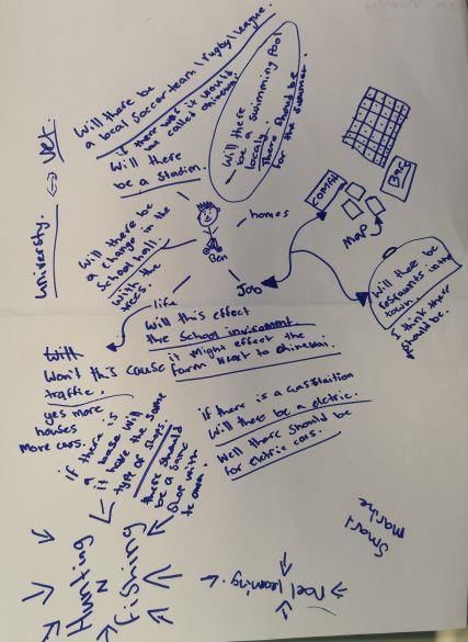
7.2 Schools.......................................................................................................................................... 29
    7.21 Schools introduction ................................................................................................................... 29
    7.22 Schools – potential effects ......................................................................................................... 31
8. Children’s voice ................................................................................................................................... 35
9. Business .............................................................................................................................................. 39
   9.1 Business introduction .................................................................................................................... 39
   9.2 Business context ........................................................................................................................... 40
   9.2 Business - potential effects ........................................................................................................... 40
10. Health, social and emergency services ............................................................................................ 44
   10.1 Health, social and emergency services introduction ................................................................... 44
   10.2 Health, social and emergency services context .......................................................................... 44
   10.3 Health, social and emergency services - potential effects .......................................................... 46
11. Lumsden Road and Tahuna Road residents .................................................................................... 48
   11.1 Lumsden Road and Tahuna Road residents’ introduction.......................................................... 48
   11.2 Lumsden Road and Tahuna Road residents’ context ................................................................. 48
   11.3 Lumsden Road and Tahuna Road - potential effects ................................................................. 49
12. Community way of life ....................................................................................................................... 51
   12.1 Ohinewai ..................................................................................................................................... 51
   12.2 Huntly .......................................................................................................................................... 52
   12.3 Te Kauwhata ............................................................................................................................... 52
13 Mitigation and monitoring ................................................................................................................... 54
   13.1 Construction ................................................................................................................................ 54
   13.2 Housing ....................................................................................................................................... 54
   13.3 Education services ...................................................................................................................... 54
   13.4 Children ....................................................................................................................................... 54
   13.5 Businesses .................................................................................................................................. 54
   13.6 Health, social and emergency services ...................................................................................... 54
   13.7 Lumsden Road and Tahuna Road residents .............................................................................. 55
   13.8 Community way of life ................................................................................................................. 55
14. Conclusion ........................................................................................................................................ 56
15. References ........................................................................................................................................ 57
Appendix 1 .............................................................................................................................................. 58

     •                                                                                                                                                     4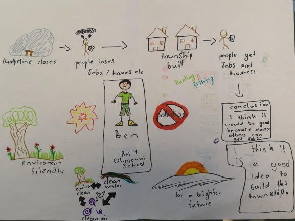
Executive summary
Introduction

Ambury Properties Limited (APL) are proposing a mixed use, masterplanned industrial, residential and
commercial development at Ohinewai. The masterplan site is adjacent to the village of Ohinewai and APL
have requested a zone change from rural land to industrial, residential and commercial. Effectively, the
masterplan proposes to create a small town within what is currently a largely rural area. The purpose of
this report is the assessment of potential social effects of the masterplan.

By the end of 2022 the first stage of housing (about 150 homes) is expected to be complete, along with
one-third of retail and one-third of industrial. As homes are constructed, a portion will first be offered to
staff working at the factory. Some homes will be available for general purchase. The full 100,000 square
metre factory of APL is dependent on four further stages (each of the four stages will be approximately 18
months in duration) and is expected to be fully completed by 2028. The remaining residential, light
industrial and retail will be built to meet demand. The 1,100 homes are expected to house 2,797 people,
while the employment created is expected to be about 1,650 from light industrial and 400 from retail.

Considering communities by place and identity, this assessment covers the townships of Huntly and Te
Kauwhata, the settlements of Ohinewai and Rangiriri, and the residents of Lumsden Road and Tahuna
Road. Considering communities of interest, the assessment covers businesses, social services, health
services, emergency services, education, and housing. Using predominantly face to face interviews and
focus group, with a few telephone interviews, 107 people/organisations were engaged by the social
assessor:

         •     Health, social and emergency services e.g. General Practices, dentist, maternal health,
               Police, Ambulance, MSD, Matahuru Papakainga Marae, etc. (23)
         •     Childcare centres, primary schools, secondary schools and Wananga (17)
         •     Businesses (25)
         •     Huntly Community Board members (3), Te Kauwhata Community Committee members (2),
               Ohinewai Community Board members (3)
         •     Lumsden Road and Tahuna Road residents (10)
         •     Primary school children at Ohinewai School (8)
         •     Real estate agents, property managers, and campground managers (7)
         •     Mayor and senior staff from Waikato District Council (5)
         •     APL and associated team (4).

The social effects for each of the major topics assessed are below:

Population and employment

The total number of staff for the masterplan is projected to be approximately 2,072. With 300 existing staff
potentially moving south from the Auckland-based NZ Comfort Group factories, this means an uplift of
approximately 1,772 staff to be hired.

Of the approximately 1,772 staff to be hired, half are projected to be hired from within the Waikato District
and 20% from within the local area, including Te Kauwhata and Huntly. Most of the balance are expected
to be hired from outside the Waikato District, but this includes Hamilton city, the Waikato Region and the
rest of New Zealand.

The social value of the jobs provided to individuals, their family and the community are positive. Most jobs
provided by the masterplan are above the minimum wage and are likely to be permanent positions. Overall,
the social effects of employment from each of the township’s existing labour pool and from migration are
projected to have a major positive social effect.

    •                                                                                                      5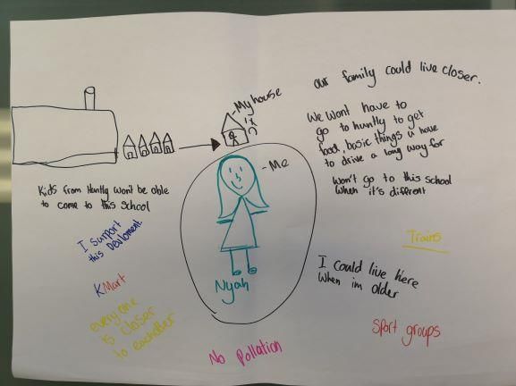
Construction

Overall, this assessment concludes that construction effects from the masterplan on local housing will be
negligible, with respect to accommodation in the surrounding townships. Most construction workers are
expected to travel from their existing homes to work at the site because of the central location of Ohinewai
to Auckland and Hamilton, and the ease of access to the Expressway. For those construction workers who
do need to live close to the site, there is potential for short term accommodation on-site, and potential for
short-term accommodation at the Huntly Domain campground.

Housing

Overall, this assessment concludes that the masterplan will likely have a neutral effect on the housing
market in Huntly. While workers at Ohinewai may settle in Huntly, the proportion expected to do so is
small. In contrast, Te Kauwhata has ample land zoned for residential growth and is viewed positively by
people moving to the Waikato District. As such, the slower-growing-than-expected Te Kauwhata housing
market is projected to be positively supported by Ohinewai workers who don’t want to live in the masterplan
site.

Effects on Ohinewai housing are projected to be positive for residents on the western side of the
expressway due to the reduced likelihood of industrial land use changes in what is desired to be a rural
residential.

Education

For early childhood education centres, this assessment concludes that the masterplan will have negligible
social effect on centres within the study area. All centres welcomed the prospect of new families moving
into the area and looked forward to local employment opportunities taking pressure off families (who
otherwise commute long distances for work). Two centres have expressed initial interest in opening an
early childhood education centre in the masterplan site, should demand require it.

For primary schools, the assessment concludes the proposed masterplan will have a minor positive effect
on schools in the study area. This arises from local families gaining employment and consequently being
able to work locally and so spend more time with their family and in their community (and school). The
moderate positive effect is also projected to arise from masterplan families migrating into communities,
bringing their diverse skills and resources to schools and the wider communities. For primary schools
where roll growth is desired, the families moving into the area may help stabilize and grow rolls.

For Ohinewai School, when taking a ‘highest case’ assessment, their roll may grow from 152 to either 300
or 400 (depending on zoning decisions). The principal and deputy principal are positive about the
masterplan and the opportunities that it offers the school, students and community. They believe the rural
character of Ohinewai School will be maintained and they welcome the short to medium term growth for
the school. They look forward to benefiting from the potable water and sewage system. The principal is
wary about potential delays for new classrooms, though delays are measured in months not years. They
acknowledge that long term (i.e. whether the school reaches the full 400 students) relies on decisions by
the Ministry of Education, which has recently stated its plan is to expand Ohinewai School. As such, the
social effect on Ohinewai School is assessed as moderate positive.

Secondary school principals also recognized the direct benefits for their students, offering hope and
providing opportunities to students to work and live locally once they become adults. Similar to primary
school principals, secondary principals also see substantial benefit to parents, students and the wider
community arising from the opportunity for parents to live and work locally, rather than spend their time on
long commutes. The effect on all secondary schools is assessed as moderate positive due to the potential
relationships with employers for transition to work programmes. Potential roll growth at Huntly College and
Te Wharekura O Rakaumangamanga arising from the masterplan is projected to be small. Roll growth at
Te Kauwhata College is projected to be about 150 students, well within the 10-year growth plans for the
College (+500). The principal of Te Kauwhata College welcomes the masterplan.
      •                                                                                                    6
Children’s voice

This assessment concludes the masterplan will have a moderate positive effect on local children. The
children clearly articulated how the masterplan would lead to positive effects for themselves and others
related to employment, housing, an increased population, retail, and recreational opportunities. The
children had a sharper focus on environmental issues than adults and were clear there should be no
pollution arising from the masterplan. One child commented on the apparent lack of facilities dedicated to
older adults. Finally, for one child, the masterplan meant she would have to ‘move house’.

Businesses

Overall, this assessment concludes the proposed masterplan will have a major positive effect on local
businesses, especially within the context of past decreases in businesses in these towns.

Business owners foresaw employment for local families and the consequent improvement in their own
businesses, and the hope for additional businesses setting up in their towns. This was true for Huntly, Te
Kauwhata and Rangiriri. For Te Kauwhata especially, there is also a potential influx of employees into their
township. This is further supported by business owners who did not see Huntly as a shopping destination,
and local retailers who had business models which meant sales came from multiple channels.

For the District, Huntly and Te Kauwhata, interviewees saw the masterplan as a solution to the limited
options for zoning further land as industrial within Te Kauwhata or Huntly. The masterplan was therefore
seen as critical for supporting growth in employment district wide, especially given the context of declining
business numbers in Te Kauwhata and Huntly.

Businesses were confident of the quality and size of labour pool that might be available to NZ Comfort
Group, especially in Huntly. Interviewees talked about the hope that the masterplan would provide for the
majority of people in the District. For the minority of people for whom unemployment is driven by deep
social issues, the additional jobs arising from the masterplan will not alleviate their situation. Collaborative
working would be required, beyond the scope of the masterplan.

Ohinewai businesses were either neutral; or for the same reasons as above: highly supportive.

Regional interviewees wish to engage with NZ Comfort Group to maximise local employment
opportunities, particularly for people in Huntly.

Health, social and emergency services

Overall, this assessment concludes the proposed masterplan will have a neutral effect on health and
emergency services, and a minor positive effect on social services.

St John, who provide ambulance services from their services in Huntly and Te Kauwhata are rapidly
expanding and have capacity for substantial growth. NZ Police also have capacity to cover an expanded
population in Ohinewai from their Huntly base, along with additional capacity for growth should it be
required.

Four of the Huntly GP services have some capacity for growth within their rolls. GP services in Te
Kauwhata and Huntly have expressed interest in providing services in Ohinewai. This would likely look like
a satellite clinic running at reduced hours, and as the population grows, the service would expand to match
demand.

Employment and housing opportunities arising from the masterplan align with Matahuru Papakainga
Marae aims for employment and housing for their people. NZ Comfort Group and marae are in discussions
about how to work together for these shared goals. Employment opportunities, especially for young people
not engaged in employment, education or training, presents a substantial opportunity. This is a challenging
space to work with numerous agencies working to improve outcomes for these young people. NZ Comfort

     •                                                                                                        7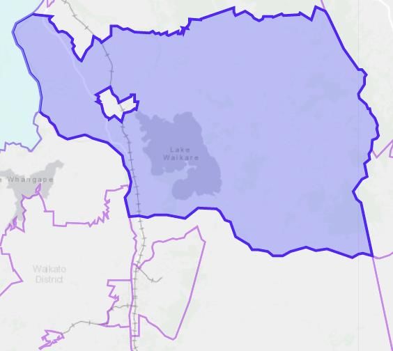
Group has the potential to provide hope for employment, and via work with the marae, iwi, MSD, schools
and other stakeholders, make a positive difference.

Emergency services, health, social services and Matahuru Papakainga Marae were supportive of the
masterplan.

Lumsden Road and Tahuna Road residents

This assessment concludes the proposed masterplan will have a neutral to minor negative effect on
Lumsden Road residents (western side of road). These residents will experience social effects arising from
the change of their rural outlook to massed plantings (to the east only).

For Lumsden Road residents (eastern side), the potential purchase of their properties is judged to lead to
a minor negative social effect because the residents will need to resettle elsewhere but this is judged by
the residents themselves to be offset by the financial compensation of purchase. If not purchased, the
social effects are judged to be moderate negative for Lumsden road residents (eastern side) because of
changes in their immediate living environment.

For Tahuna Road residents, due to the distance from the development, the social effect is assessed as
neutral.

Community way of life

Overall, this assessment concludes that the proposed expansion will have a positive social effect on the
western side of Ohinewai, providing future zoning decisions support aspirations for rural living on that side
of the Expressway and environmental compliance is managed. For residents on Lumsden Road (western
side), there would be a neutral effect as they perceive little change to how they would live their life. For
Lumsden Road residents (eastern side) there would be a moderate negative effect because they believe
they will have to move.

For Huntly, the masterplan is projected to complement the community’s aspirations. The masterplan is
projected to provide a source of hope regarding local employment and business confidence. This is
particularly true for those who are currently unemployed or under employed. Appropriate public transport
is required for much of the employment benefit to accrue.

For Te Kauwhata, the masterplan is projected to complement the community’s growth aspirations by
providing a source of employment for people who might purchase within the substantial subdivisions
already consented. Being locally employed, these people have a greater chance of contributing positively
to Te Kauwhata, supporting the existing, well-formed social structures.

Mitigation and monitoring

Several situations exist to continue sharing information with interested parties. However no mitigation or
monitoring is required.

Conclusion

It is projected the masterplan has potential District-wide social benefits arising from employment. Local
people look forward to the jobs and income from the masterplan, especially those in Huntly. The
employment is within an environment of low median incomes and declining numbers of businesses in
Huntly and Te Kauwhata. Furthermore, the social benefits of employment are substantial, at the individual,
family and community level.

Similarly, it is projected the masterplan has potential District-wide social benefits arising from housing. The
masterplan will provide affordable housing, allowing people to live, work and play in the same township.
The employment-led masterplan is projected to help maintain the population of Huntly (which is declining)
and support the housing-led development in Te Kauwhata (which has not grown at the rate expected).
     •                                                                                                       8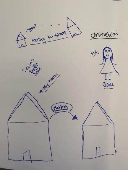
One potential minor negative social effect relates to the three houses on the eastern side of Lumsden
Road who may sell/move Negotiations are currently underway with respect to the purchase of those
properties that are within the proposed rezoning area.

Overall, the masterplan is projected to positively contribute to the way of life of local communities.

    •                                                                                                    9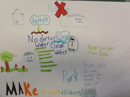
1 Introduction
Ambury Properties Limited (APL) is seeking the rezoning of current rural zoned land in Ohinewai to enable
a masterplan of mixed use, industrial, commercial and residential community. The re-zoning is being
sought via the Proposed Waikato District Plan (PWDP) planning process, with APL lodging submissions
to the PWDP to support their objectives for their subject property.
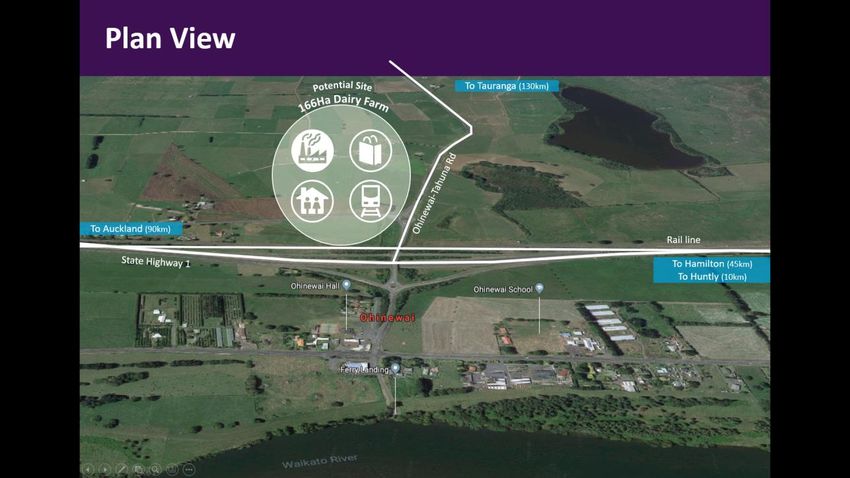
The Ohinewai Masterplan (Figure 1) (hereafter ‘masterplan’) site is adjacent to the existing township of
Ohinewai and includes 178 hectares with:
• 100,000 square metre (GFA) factory to house a large primary tenant with direct rail siding access
• Other industrial buildings with direct rail siding access
• Further light industrial buildings within approximately 30.3 hectares (approximately 133,000
square metres GFA) without direct rail siding access
• All Industrial buildings will have access to the rail siding via a road at the back of the APL factory
• Approximately 1,100 homes comprising a mix of semi-detached and detached (stand-alone)
houses
• A Business Zone of approximately 43,440 square metres GFA including:
o Service centre with truck stop and convenience retail
o Emergency services building
o Bus depot
o Factory outlet stores (as a shopping destination)
• Road access to feeder roads onto State Highway 1 (SH1) (Waikato Expressway)
• Community hall/facility/hub
• Community corner shop
• Sports fields
• Market garden, processing area and café
• Orchard, beehives, processing area
• Parks, wetlands and shared pathways/connections to DOC Reserve.
Figure 1. The masterplan site
• 10The primary tenant is proposed to be NZ Comfort Group Limited (NZ Comfort Group), whose brands
include Sleepyhead, SleepMaker and Dunlop Foams. The existing NZ Comfort Group factories are in
South Auckland and Avondale. Up to 1,500 staff are expected to be employed at the new state of the art
factory in Ohinewai, greatly expanding from current operations in Auckland. A rent-to-own scheme (or
similar) for staff housing is being considered, and discussions with Waikato-Tainui are underway regarding
training/local employment.
1.1 Purpose and objectives of the report
The purpose of this report is the assessment of potential social effects of the proposed masterplan,
including both potential positive and negative effects. The assessment will identify and recommend
mitigation to minimise potential effects and maximise the uptake of potential social benefits.
The objectives are to:
• Draw from and build upon the outputs of the regulatory planning and assessment process (e.g.
other assessments) and collect bespoke data from stakeholders
• Identify and describe any potential social effects (positive or negative) from the proposed
masterplan
• Make evidence-based recommendations to maximise positive effects and minimise negative
effects
• Work with key social stakeholders to explore potential monitoring strategies for any potential
social effects identified.
The potential social effects have been assessed by considering the difference between the proposed
increase in housing, retail and light industrial businesses and social/recreational services against a no-
change scenario.
1.2 The site
The site for the proposed Sleepyhead Estate is currently agricultural land including a few farmhouses,
bounded at the north by Balemi Road, to the south by Tahuna Road, to the west by Lumsden Road and
to the east by Department of Conservation land. The site is adjacent to 11 residential neighbours (41-85,
52 to 58 Lumsden Road). Further to the west, across SH1, is the village of Ohinewai.
Ohinewai is a village in the Waikato District within the Waikato Region. It is sited on the banks of the
Waikato River and adjacent to SH1. Ohinewai is north of Huntly (8km), Ngaruawahia (24km), Hamilton
CBD (39 km, 40-minute drive) and south of Pukekohe (47km) and Papakura (55 km, 40-minute drive).
The zoning for the site in the Operative and Proposed Waikato District Plans is presently Rural. The
rezoning requested should come into effect in 2020. There are no local roads that dissect the masterplan
site.
The existing dairy farm is operated by Graham and Sue Bower, employing two people and four people live
on site.
1.2 The masterplan
Upon confirmation of the proposed zoning, APL will obtain consent to construct, operate and maintain the
masterplan site. If confirmed, the additional activities would include the following.
1.2.1 The primary tenant and approximate timing
The primary industrial tenant is NZ Comfort Group. It is proposed to relocate existing NZ Comfort Group
factories (including administration) from South Auckland and Avondale to this new site. The total number
of staff (over time, annually last 5 years) is reflected in Table 1.
• 11Table 1. Total number of NZ Comfort Group staff over past five years.
Year Total number of staff (factory
and administration)
April 2014- March 2015 418
April 2015 – March 2016 419
April 2016 to March 2017 445
March 2017 to April 2018 463
March 2018 to April 2019 447
Initial work by NZ Comfort Group estimates about 300 staff are considering moving to the new
manufacturing site. The new factory is expected to be staffed by about 500 workers initially and could grow
to 1500 as all manufacturing operations are consolidated onto the property. Therefore, taking a mid-point
of 1,000 workers (in an expanded operation), a further 700 staff are expected to be hired, with some of
those from Huntly and Te Kauwhata. NZ Comfort Group are entering discussions with Waikato-Tainui and
other iwi organisations, to encourage local employment. Planning is underway for Huntly locals to be
trained/employed in South Auckland factories first (staff are currently being bussed up/back each day) to
be ready to begin operations in Ohinewai once the stage one factory opens.
It is envisaged the stage one factory (approximately 22,000 square metres, employing about thirty staff)
will be operational first, by the end of 2021; potentially along with the service centre. Staff in Auckland will
be offered the opportunity to work in the new stage one factory. Auckland staff will have the option of being
able to travel from Auckland to work in Ohinewai by a company bus, until the first of the residential housing
is complete. A small number of administrative staff will also be required to be employed on site for the
stage one factory, and it is expected the balance of administrative staff will be employed on site in stages
two and three.
By the end of 2022 the first stage of housing (about 150 homes) is expected to be complete, along with
one-third of retail and one-third of light industrial. As homes are constructed, a portion will be offered to
staff working at the factory. Other homes will be available for general purchase.
The full 100,000 square metre factory of NZ Comfort Group is expected to be operational by end of 2028.
The remaining residential, light industrial and retail will be built to meet demand.
1.2.2 Other industrial tenants
Alongside the primary tenant, the masterplan allows for additional light industrial buildings within 30.3
hectares (approximately 133,000 square metres GFA), all with rail siding access. An average light
industrial building is approximately 12,000 square metres and it is envisaged about one staff member per
200 square metres, and so it is projected that these businesses would (approximately) support the
following:
• Projected number of businesses: 10
• Projected number of staff: 650.
1.2.3 Retail and other businesses
The masterplan projects approximately 43,000 square metres GFA of factory outlet stores, a community
corner store, market garden and processing area, orchard and beehives, market garden café, and a ‘fuel
stop’/service centre for trucks and cars with convenience retail. With an average bulk retail store being
about 5,000 square metres and an employee each 150 square metres, the GFA available equates to about
12 businesses with an estimated 400 employees in total.
• 121.2.4 Housing
The masterplan projects 1,100 homes comprising about 740 multi-units and 360 detached houses.
Applying a housing density of 2.5 people per household, this presents a total population of 2,750, including
559 children under the age of 18 years.
1.2.5 Support services
To support the people in the residences and businesses an emergency service building (about 4 staff),
bus depot (about 2 staff); possible reinstatement of historic train station (no staff projected in near future),
and community centre/ hub/ agricultural projects (about 10 staff), caretaker/ security/ landscaping (about
6 staff) is proposed. These contribute an additional 22 staff.
1.2.6 Recreation
Along with retail shopping and community hall/facility/hub, the masterplan is proposing parks, wetlands
and shared pathways/connections to the DOC Reserve; and sports fields.
1.2.7 Connections to Huntly
The Masterplan is proposing a cycleway down the old highway to connect Huntly, along with a bus station
to support potential bus services. Connections by car (and bus) are rapid, via the Waikato Expressway,
with a full cloverleaf interchange at Ohinewai to support vehicle travel to or from, north or south.
• 132. Approach and methodology
2.1 Statutory framework
For this project, the statutory framework for the assessment is provided by the Resource Management Act
1991 (RMA). Section 5 of the RMA states the purpose of the Act is “to promote the sustainable
management of natural and physical resources.”
Sustainable management is defined by the RMA as “managing the use, development, and protection of
natural and physical resources in a way, or at a rate, which enables people and communities to provide
for their social, economic, and cultural well-being and for their health and safety while—
a) sustaining the potential of natural and physical resources (excluding minerals) to meet the
reasonably foreseeable needs of future generations; and
b) safeguarding the life-supporting capacity of air, water, soil, and ecosystems; and
c) avoiding, remedying, or mitigating any adverse effects of activities on the environment.”
Accordingly, this assessment is necessary to assist the determination of whether the proposed masterplan
will enable people and communities to provide for their social well-being while avoiding remedying or
mitigating any adverse social effects on the people and communities surrounding the site.
2.2 Conceptual framework
Social impact assessment (SIA) is the most common framework used in New Zealand and internationally
to analyse, monitor and manage the social consequences of development. SIA can inform the choice of
options, design and resource consent applications of projects.
The International Association of Impact Assessment (2003; 2015) describes social impacts as impacts on
one or more of the following:
• People’s way of life – that is, how they live, work, play and interact with one another on a day- to-
day basis
• Their culture – that is, their shared beliefs, customs, values and language or dialect;
• Their community – its cohesion, stability, character, services and facilities
• Their political systems – the extent to which people are able to participate in decisions that affect
their lives, the level of democratisation that is taking place, and the resources provided for this
purpose
• Their environment – the quality of the air and water people use; the availability and quality of the
food they eat, the level of hazard or risk, dust and noise they are exposed to; the adequacy of
sanitation, their physical safety, and their access to and control over resources
• Their health and wellbeing – health is a state of complete physical, mental, social and spiritual
wellbeing and not merely the absence of disease or infirmity
• Their personal and property rights – particularly whether people are economically affected, or
experience personal disadvantage which may include a violation of their civil liberties
• Their fears and aspirations – their perceptions about their safety, their fears about the future of
their community, and their aspirations for their future and the future of their children.
SIA cannot start with a checklist of potential impacts but must identify the social impacts from an
awareness of the project and an understanding of how the project might affect what is important to the
project’s stakeholders (IAIA, 2015). Fortunately, data is available on the masterplan, on the local
communities of Te Kauwhata, Huntly and Ohinewai.
To complement the above information, site and stakeholder specific information was considered to further
understand the proposed masterplan and what might be important to stakeholders. The new information
was:
• Discussions with APL about existing stakeholders and stakeholder relationships
• 14• Site visit to Ohinewai (27 June 2019)
• Discussions with economic impact assessors and consideration of their data
• Maps of the Waikato region (Google).
Taken together, the above information was used to provide a conceptual basis for this assessment, by
answering whether there may be construction and operational social effects:
1) Arising from new businesses and employment
2) Arising from new staff and new residents
3) On community way of life, on sense of place, liveability and aspirations for the future
4) Arising from being a direct neighbour
5) Arising from the transport needs of staff, construction workforce, materials, etc.
This assessment focuses on items 1-4. Item 5 is covered in a transport impact assessment, though the
social consequences of transport are covered in this report.
2.3 Geographic study area
There are several considerations in the study area. The first is to identify where new staff might live.
Because the staff will build up over time, as will the housing in the masterplan, it is expected that many of
the initial staff will be bussed down from Auckland and the balance hired locally. Initial discussions with
NZ Comfort Group and the Waikato District Council suggested the following areas will provide labour:
• Ohinewai and the new masterplan area (extremely small until the residential area develops)
• Huntly
• Te Kauwhata
• Rangiriri (extremely small)
• Other areas within the Waikato Region e.g. rural townships and Hamilton
• Other areas in the Auckland Region e.g. Pokeno and Pukekohe.
Because any social effects on large urban areas such as Hamilton and Auckland would be less than minor,
the study area is Ohinewai, Huntly, Te Kauwhata, and Rangiriri, all within the Waikato District.
As a second focus, when considering whether the study area should be the rural or urban areas, the
Waikato District Council staff were adamant that if any effects were felt, it would be in the urban areas
rather than rural because:
• The rural areas have stringent regulations regarding development whereas the urban areas
(and the halo’s around them) have more permissive planning regulations allowing
development
• The rural areas have lightly trafficked roads and low population density.
A third consideration when considering the study area was to understand the potential effects on direct
neighbours living close to the masterplan site (a rural area). Therefore, those who lived along the Lumsden
Road (Lumsden Road residents) and Tahuna Road (Tahuna road residents) were included.
2.4 Potentially affected groups and key assessment questions
Drawing on the discussions above in Sections 2.2 and 2.3, the key assessment questions to be answered
by this social impact assessment is: What are the potential social effects on the following potentially
affected groups:
• Townships of Huntly and Te Kauwhata, and settlements of Ohinewai and Rangiriri and their
associated social, health, emergency, and education services, and businesses
• Lumsden Road (east and west sides) and Tahuna Road residents.
• 152.5 Consultation
Beyond the information sources listed in Section 2.2 and 2.3 above, the predominant method of gathering
information about the existing situation and potential social effects was to ask those with most experience
in such matters, be they community members from the townships/settlements in the study area, or regional
experts.
Consequently, a substantial consultation programme was planned and undertaken to seek out information
on the above topics, and probe for any other potential impacts not already identified. Using predominantly
face to face interviews and focus group, with a few telephone interviews, 107 people/organisations were
engaged by the social assessor:
• Health, social and emergency services e.g. General Practices, dentist, maternal health,
Police, Ambulance, MSD, Matahuru Papakainga Marae, etc. (23)
• Childcare centres, primary schools, secondary schools and Wananga (17)
• Businesses (25)
• Huntly Community Board members (3), Te Kauwhata Community Committee members (2),
Ohinewai Area Committee members (3)
• Lumsden Road and Tahuna Road residents (10)
• Primary school children at Ohinewai School (8)
• Real estate agents, property managers, and campground managers (7)
• Mayor and senior staff from Waikato District Council (5)
• APL and associated team (4).
The in-person interviews were undertaken in the local villages of Ohinewai and Rangiriri, and townships
of Te Kauwhata and Huntly, across six trips: 27th and 28th June; 3rd and 4th July; 18th and 19th July;
24th and 25th July; 31st July and 1st August; and 27th August 2019.
A public meeting was held in Ohinewai on 19th June 2019, attended by approximately 150 people to hear
about the masterplan and ask questions.
Of those participants who represented community organisations, e.g. a school, many also lived locally.
People speaking directly on behalf of community included community board members, plus the many
community members who attended the public meeting.
2.6 Assessment of effects
Data were considered by the assessor to determine whether a social effect would occur or not. Both
positive, negative and neutral effects were considered. Where effects were concluded to occur, the nature
of the effect was characterised:
• Severity of effect (major, high, moderate, minor, neutral) (See Table 9 in Appendix 1 for further
description)
• Magnitude of effect (many affected; moderate number; few affected)
• Permanence of effect (permanent; medium term, temporary)
• Inequity of effects (effect concentrated to particular groups; unsure but possible inequity; widely
distributed, universal effect)
• Likelihood of effect occurring (almost certain; likely; unlikely)
• Ease of mitigation (very difficult, very costly; moderately able; easy to mitigate).
• 163. Community profiles
As described above, the study area is Ohinewai, Huntly, Te Kauwhata and Rangiriri. Data for the census
area units relating to these areas are described below.
3.1 Introduction
The Waikato District (See Figure 2) has experienced continuous population growth to 63,381 people in
2013 (10.1 per cent growth since the 2006 census, and 22.3 per cent growth since the 2001 census)1.
Figure 2. Map of Waikato District and townships
The Waikato District sits within the western boundary of the area described by economic commentators
as ‘the golden triangle’: The geographic (triangular) area between Tauranga, Auckland and Hamilton. The
1 All population data is taken from the 2013 Census. While it is acknowledged that the data has likely changed (increased) since that
time, it is sufficient to inform the community profile for this report.
• 17Hamilton to Auckland Growth corridor (State Highway 1 and main trunk rail line) also run through the
District, and roughly matches this western boundary of the golden triangle.
Growth has come from servicing the rural Waikato economy, and being within commuting distance of
Hamilton and Auckland employment/services.
Huntly is the largest township (population 6,954) in the Waikato District, followed by Ngaruawahia
(population 5,127), Tuakau (population 4,182), Raglan (population 2,736) and Te Kauwhata (population
1,473). In contrast, Ohinewai and Rangiriri (populations of 159 and 63) are best described as villages.
Without a major urban centre, the District does not have a retail or hospitality destination. Like most rural
areas in New Zealand, the land mass of the Waikato District is large. Therefore, access to quality services
varies from excellent to poor, dependent on the service required and the geographic location lived in.
The rural areas surrounding each of the townships are those that can be experienced all over New
Zealand. Lightly populated, zoned rural, and a patchwork-quilt of green grass. For the Waikato District,
dairy farming and processing is the most significant industry.
3.2 Population
Population data is presented at two levels, Statistical Area 2 (SA2) level which is a larger geographic area
and suitable for townships; and Census Area Unit (smallest geographic area) which is more suitable for
villages such as Ohinewai and Rangiriri (Table 2).
The data covers 2001, 2006, and 2013. While 2018 estimates are available, at the SA2 level the accuracy
is variable, and hence not reported. Te Kauwhata and the surrounding rural area: Waerenga (see Figure
4 in Appendix 1), which extends down to Ohinewai; have both experienced substantial growth between
2001 and 2013. At about 3 percent and 4 percent growth per annum, these would be considered ‘high
growth’ if they were an urban area. For popular rural areas however, this is not uncommon, reflecting fewer
people to begin with (i.e. growth off a low base), demand for more affordable housing options and demand
for lifestyle block living.
In contrast, population decline in Huntly West and little growth for Huntly East is seen over the same
twelve-year period.
The (much smaller) census area units around Ohinewai and Rangiriri present a mixed picture, albeit based
on very small populations. Such small numbers mean that percentages are often over- or under-stated
and use of percentage change is therefore not reported. Broadly however, Rangiriri is seeing a steady
decrease in population (about two people per year), while the CAUs North of Lumsden Road and Around
Ohinewai School show an increase in population of about one person per year. See Appendix 1 for Figures
5 and 6 displaying CAU images for Rangiriri and Ohinewai).
Table 2 – SA2 and Census Area Unit, population data
Per cent
Population (Number of dwellings) by Census change
2001 2006 2013 2001 to 2013
SA2s
Te Kauwhata 1,095 1,194 1,473 +35%
(432) (468) (561)
Waerenga (large rural area which includes 1698 1,785 2,538 +49%
Ohinewai, and surrounds of Te Kauwhata) (582) (615) (672)
Huntly West (171400) 2,922 2,925 2,835 -3%
(876) (918) (906)
Huntly East (171500) 3,900 3,909 4,122 +6%
(1,446) (1,479) (1,557)
• 18Ohinewai CAUs
Rural living north of Ohinewai School 45 42 48 (insufficient
(0939100) (18) (18) (18) numbers)
Around Ohinewai School (0941700) 12 18 24 (insufficient
(3) (6) (9) numbers)
Rural living south of Ohinewai school 30 33 33 (insufficient
(0940701) (12) (15) (15) numbers)
North of Tahuna Road, including Lumsden 33 48 48 (insufficient
Road area (0939302) (15) (15) (15) numbers)
South of Tahuna Road area (0941600) 0 12 6 -
(0) (3)
Rangiriri CAU
Rangiriri (0938602) 90 75 63 (insufficient
(27) (24) (21) numbers)
3.3 Te Kauwhata, Waerenga, Huntly East and Huntly West
Te Kauwhata has a population of 1,473, and the town is sited 12 km north of Ohinewai and 39km south of
Pukekohe (within Auckland Council). Waerenga (see Figure 4 in Appendix 1) is a large rural area
surrounding Te Kauwhata and extending south to include Ohinewai. Huntly West and Huntly East (see
Figure 8 in Appendix 1) are situated 32 km north of Hamilton and 8km south of Ohinewai. Huntly West
and Huntly East are bisected by the Waikato River, with SH1 and the main trunk rail also running through
Huntly East. Data from the relevant census area units is displayed below in Table 3.
Table 3 – Te Kauwhata, Waerenga, Huntly East and Huntly West
Census area unit Aged 65+ Median Per cent House NZ
(per cent) income Maori/European2 ownership Deprivation
(per cent) Index3
Te Kauwhata 25 $25,000 21/82 64 7
Waerenga 9.5 $25,500 23/70 61 6
Huntly East 17 $22,800 33/70 56 9
Huntly West 10 $19,100 70/39 43 10
2 People can self-identify with more than one ethnic group so totals do not sum to 100
3 The NZ Deprivation Index combines census data relating to income, home ownership, employment, qualifications, family
structure, housing, access to transport and communications. Meshblocks (the smallest geographic area from census data) are
grouped into deciles, where 1 represents the areas least deprived and 10 the areas most deprived.
• 19These data show that compared to the proportion of people greater than 65 years in New Zealand (14
percent), the populations of Waerenga and Huntly are younger, and Huntly East and Te Kauwhata older.
In New Zealand, 15 percent of people belong to the Maori ethnic group. This compares with 21 percent in
Te Kauwhata, 23 percent in Waerenga, 33 percent in Huntly East and 70 percent in Huntly West. Home
ownership is lowest in Huntly West, followed by Huntly East and Waerenga, with only Te Kauwhata
equalling the national average of home ownership of 64 percent. None of the areas profiled match the
national average income of $28,500, with the lowest being Huntly East ($22,800) and Huntly West
($19,100). Waerenga is rated about the national average (of five to six) on the NZ Index of Deprivation 4
(Waerenga: 6), while Huntly East (9) and Huntly West (10) are some of the most deprived areas in New
Zealand.
Ohinewai CAUs and Rangiriri CAU
The NZ Index of Deprivation data for each of the CAUs is presented below (Table 4). A graphical
representation is in Appendix 1, Figure 7). Table 4 shows a slightly higher level of deprivation for the
Ohinewai CAUs of seven, compared with the wider Waerenga SA2 area’s deprivation value of six. Rangiriri
is lower again at eight. The area in which the masterplan is proposed, which has a value of five, is an
average area in New Zealand when Deprivation/Privilege is considered.
Table 4. NZ Deprivation Index for CAUs and SA2
CAUs and SA2 NZ Index of
Deprivation
Ohinewai CAUs -
Rural living north of Ohinewai School (0939100) 7
Around Ohinewai School (0941700) 7
Rural living south of Ohinewai school (0940701) 7
North of Tahuna Road, including Lumsden Road 5
area (0939302)
South of Tahuna Road area (0941600) 7
Rangiriri CAU -
Rangiriri (0938602) 8
Waerenga SA2 area 6
4The NZ Deprivation Index combines census data relating to income, home ownership, employment, qualifications, family structure,
housing, access to transport and communications. Meshblocks (the smallest geographic area from census data) are grouped into
deciles, where 1 represents the areas least deprived and 10 the areas most deprived.4. Population and employment – context and potential effects
As discussed in section 2.2, one way the proposed masterplan might create social effects is through local
people being employed and/or staff moving to the townships/city nearest. Table 5 below describes the
total number of staff that may be needed. This is an approximate number because staffing requirements
may vary.
Table 5. Approximate number of additional staff needed
Employment Additional
employees
Proposed expansion to Sleepyhead factories 700
(1,000 minus about 300 staff moving south)
Additional light industrial staff 650
Additional retail staff 400
Additional support service staff 22
Total staff to be hired (best estimate) 1,772
Hiring staff from Huntly is a stated aim of NZ Comfort Group. NZ Comfort Group is also entering
discussions with Waikato-Tainui to encourage local employment. Planning is underway for Huntly locals
to be trained/employed in South Auckland factories first (staff are being bussed up/back each day) to be
ready to begin operations in Ohinewai once the stage one factory opens.
Other stakeholders also wish to work alongside NZ Comfort Group to maximise local employment. These
include the Ministry of Social Development regional office, and both Te Kauwhata College and Huntly
College.
The economic impact assessment (Property Economics, 2019) assumes:
• No current Sleepyhead workers reside in the region (i.e. they all live in the Auckland Region)
• All future Sleepyhead workers will live in the Waikato Region, with up to 70 per cent of those
future workers living within the local catchment (includes the townships of Huntly and Te
Kauwhata) by 2031.
Property Economics (2019) also projects half of the workforce will be hired from within the Waikato District,
with 20% hired from within the local area. Most of the balance are expected to be hired from outside the
Waikato District, but this includes Hamilton city, the Waikato Region and the rest of New Zealand.
It is projected that the staff moving for employment will mostly settle within the Waikato Region, with a
small proportion who will drive substantial distances, living out of the region. Regarding where the hired
migrant staff (and their families) might live, the best estimate is based on where the major accommodation
markets are now (Hamilton, Te Kauwhata, Huntly and the proposed masterplan site.
Urban centres are desired by New Zealand families and given the growth experienced in Te Kauwhata
and Hamilton City (driven by their popularity with migrant families and workers), it is expected these two
(together with the masterplan site) will attract the bulk of workers who mover for employment. The many
townships in the Waikato Region will also attract a modest proportion of the new migrant families, and
Huntly will remain less popular as per the past, until/unless Huntly is able to shed the negative perception
many outsiders hold about the town.
The social effects of this employment from within each township’s existing labour pool and migration into
each township, are potentially substantial. For example, further sections in this study consider the potential
• 21effects of migration on the education system, the health system, housing, etc. Other sections do not
consider the benefits of employment explicitly, so these are briefly described here.
The social effects of employment are substantial: for an individual, the individual’s family including children,
and community. At the individual and family level, employment contributes to outcomes such as living
standards, health and wellbeing, mental health, social connection, personal identity and life satisfaction.
At the community level, employment contributes money and resources to a community, social capital and
social cohesion, and contributes more broadly to achieving societal goals. To sum up, employment and
consequent income are the two largest determinants of a person’s (and their household’s) health and
wellbeing. Further details are available in Social value of a job (Ministry for Primary Industries, 2016).
“This will be transformational for our clients. To be able to offer them a range of jobs will be
excellent.” (MSD Regional interviewee)
Of local relevance, the median income in most of the surrounding areas is low, reflecting the predominant
low wage economy and relatively high proportions of people on benefits, be that superannuation in Te
Kauwhata, or unemployment and sole parent benefit in Huntly. While the masterplan will also create some
low wage jobs, most jobs will be at incomes substantially higher than experienced by many living in the
study area. For example, an average factory worker at NZ Comfort Group earns approximately $41,700.
Twenty-seven percent higher than the minimum wage salary of $32,760 (40-hour week, 52 weeks).
Furthermore, NZ Comfort Group jobs are stable, permanent positions, which increase the likelihood of
achieving the individual and family social benefits described above (in contrast to insecure, piecemeal
employment).
Overall, the jobs provided by the masterplan are projected to have a ‘major’, positive effect on ‘many’
people. The likelihood of the effect occurring is ‘almost certain’.
The total number of staff for the masterplan is projected to be approximately 2,072. With 300 existing
staff potentially moving south from the Auckland-based NZ Comfort Group factories, this means an uplift
of approximately 1,772 staff to be hired.
Of the approximately 1,772 staff to be hired, half are projected to be hired from within the Waikato District
and 20% from within the local area, including Te Kauwhata and Huntly. Most of the balance are expected
to be hired from outside the Waikato District, but this includes Hamilton city, the balance of the Waikato
Region and the rest of New Zealand.
The social value of the jobs provided to individuals, their family and the community are positive. Most
jobs provided by the masterplan are above the minimum wage and are likely to be permanent positions.
Overall, the social effects of employment from each of the township’s existing labour pool and from
migration are projected to have a major positive social effect.
• 22You can also read