Notice of Requirement by the New Zealand Transport Agency for Alteration of Designation for SH1N Kensington Avenue to Manse Street Safety ...
←
→
Page content transcription
If your browser does not render page correctly, please read the page content below
NZ Transport Agency - NOR for Alteration of Designation
          for SH1N Kensington Avenue to Manse Street Safety Improvements, Whangarei District

  Notice of Requirement by the New Zealand
Transport Agency for Alteration of Designation
 for SH1N Kensington Avenue to Manse Street
   Safety Improvements, Whangarei District
NZ Transport Agency - NOR for Alteration of Designation
          for SH1N Kensington Avenue to Manse Street Safety Improvements
                                                            Improvements, Whangarei District

  Notice of Requirement by the New Zealand
Transport Agency for Alteration of Designation
 for SH1N Kensington Avenue to Manse Street
   Safety Improvements, Whangarei District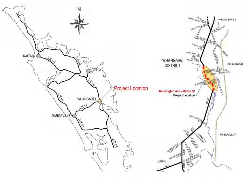
NZ Transport Agency - NOR for Alteration of Designation
                                         for SH1N Kensington Avenue to Manse Street Safety Improvements, Whangarei District

Contents
Form 18................................................................................................................................................... 9

1.         Introduction ............................................................................................................................................... 12
     1.1       Structure of this Report ......................................................................................................... 12
     1.2       Outline of the Project ............................................................................................................ 12
     1.3       Land Included in NOR Application ......................................................................................... 15
     1.4       Resource Consents ................................................................................................................ 18

2.         NZTA Framework ...................................................................................................................................... 19
     2.1       Legislative Framework ........................................................................................................... 19
     2.2       Connecting New Zealand ....................................................................................................... 19
     2.3       Government Policy Statement on Land Transport Funding .................................................. 19
     2.4       NZTA Environment and Social Responsibility Policy ............................................................. 20
     2.5       Safer Journeys ....................................................................................................................... 21
     2.6       Regional Land Transport Strategy ......................................................................................... 21

3.         Reason for the Works and Designation .................................................................................................... 23
     3.1       Need for the Project .............................................................................................................. 23
3.1.1           The Problem .......................................................................................................................... 23
3.1.2           Proposed Solution ................................................................................................................. 24
     3.2       Need for the Alteration to the Designation .......................................................................... 25

4.         Description of the Existing Environment ................................................................................................... 27
     4.1       General Site Location and Description .................................................................................. 27
     4.2       Traffic and Transport ............................................................................................................. 27
     4.3       Archaeology ........................................................................................................................... 27
     4.4       Cultural Heritage ................................................................................................................... 27
     4.5       Services and Network Utilities............................................................................................... 28
     4.6       Noise and Vibration ............................................................................................................... 29
     4.7       Ecology................................................................................................................................... 29
     4.8       Ground Conditions ................................................................................................................ 30
     4.9       Landscape and Vegetation Removal ..................................................................................... 32
     4.10      Kensington Park ..................................................................................................................... 33

5.         Description of the Project .......................................................................................................................... 34
     5.1       Project Description (Operational) ......................................................................................... 34
5.1.1           General Project Description .................................................................................................. 34
5.1.2           Specific Project Description .................................................................................................. 34

                                                                              3
NZ Transport Agency - NOR for Alteration of Designation
for SH1N Kensington Avenue to Manse Street Safety Improvements, Whangarei District
5.2 Project Description (Construction) ........................................................................................ 35
5.2.1 Introduction .......................................................................................................................... 35
5.2.2 General Construction Activities ............................................................................................ 35
6. Assessment of Alternatives ...................................................................................................................... 36
6.1 Purpose of the Assessment ................................................................................................... 36
6.2 Assessment of Alternative Routes, Alignments and Interchanges........................................ 36
7. Consultation .............................................................................................................................................. 38
7.1 Introduction ........................................................................................................................... 38
7.2 Summary of Issues ................................................................................................................. 38
8. Assessment of Environmental Effects ...................................................................................................... 40
8.1 Introduction ........................................................................................................................... 40
8.2 Assessment Methodology ..................................................................................................... 41
8.3 Traffic and Transport ............................................................................................................. 41
8.4 Archaeology and Cultural Heritage ....................................................................................... 45
8.5 Services and Network utilities ............................................................................................... 45
8.6 Lighting .................................................................................................................................. 45
8.7 Noise and Vibration ............................................................................................................... 45
8.8 Ecology................................................................................................................................... 48
8.9 Earthworks, Stormwater and Water Quality ......................................................................... 49
8.10 Groundwater ......................................................................................................................... 50
8.11 Economic and Social Effects .................................................................................................. 50
8.12 Landscape/Visual Effects ....................................................................................................... 50
8.13 Kensington Park ..................................................................................................................... 53
8.14 Positive Effects ...................................................................................................................... 54
8.15 Overall Assessment of Effects ............................................................................................... 54
9. Management of Environmental Effects ..................................................................................................... 55
9.1 Introduction ........................................................................................................................... 55
9.2 Summary of Design Changes Made to Avoid or Remedy Effects .......................................... 55
9.3 Summary of Mitigation and Monitoring to Manage Adverse Effects ................................... 55
9.4 Proposed Designation Conditions ......................................................................................... 56
10. Statutory Assessment ............................................................................................................................... 57
10.1 Introduction ........................................................................................................................... 57
10.2 Relevant Policies, Plans, Standards and National Policy Statements etc .............................. 58
11. Part 2 RMA ............................................................................................................................................... 65
4NZ Transport Agency - NOR for Alteration of Designation
for SH1N Kensington Avenue to Manse Street Safety Improvements, Whangarei District
12. Outline Plan .............................................................................................................................................. 67
13. Lapse Period ............................................................................................................................................. 68
14. Summary................................................................................................................................................... 69
Attachments:
A. Designation Boundaries – Current and Proposed
District Plan Maps
Regional Water and Soil Plan Map
B. Design Plans
Ba. HCV Tracking
Bb. Powhiri Ave Guardrail
Bc. Kensington Park Car Parking
Bd. Car Parking and Manoeuvring
Be. Headlight Sweep
C. Plan of Land Entry Required
D. Plan of Land Required
Da. Existing NZTA and WDC Land Used as Highway/Road to be Included in Designation
E. Site Photos
F. Design Report (DR) 1
G. Scheme Assessment Report (SAR) 2
H. Construction Program and Draft Noise Management Plan
I. Geotechnical Report
J. Stormwater Analysis Report
K. Archaeological Reports
L. Acoustic Report
La. Acoustic Report - response to further information request 1
Lb. Acoustic Report - response to further information request 2
M. Landscape and Visual Assessment
Ma. Urban Design Report
Mb. Landscape – Response to Further Information Request
N. Earthworks Plan
Erosion and Sediment Control Plan
O. Consultation Record
P. Conditions
Q. Tree Assessment
Tree Plan
Qa. Kensington Park Consultation and Tree Relocation
Qb. Existing Tree Schedules
Qc. Kensington Park Tree Schedule
R. Modelling Data
S. Further Information Request 1
Sa. Further Information Response 1
Sb. Further Information Request 2
Sc. Further Information Response 2
1
Only the Design Report is included, because of the size of the attachments, these are provided separately on disc.
2
Only the Scheme Assessment Report is included, because of the size of the attachments, these are provided
separately on disc.
5NZ Transport Agency - NOR for Alteration of Designation
for SH1N Kensington Avenue to Manse Street Safety Improvements, Whangarei District
RESOURCE MANAGEMENT (FORMS, FEES AND PROCEDURES) REGULATIONS 2003
FORM 18
NOTICE OF REQUIREMENT FOR ALTERATIONS TO A DESIGNATION UNDER SECTION 181 OF THE
RESOURCE MANAGEMENT ACT 1991
To: Chief Executive Officer
Whangarei District Council
PO Box 9023
WHANGAREI
1. The New Zealand Transport Agency (NZTA) gives notice, pursuant to s 181 of the Resource
Management Act (RMA), of a requirement for alterations to a designation in the Whangarei
District Plan (DTNZ 1, which is listed as a Designation in Chapter 85 of the District Plan) being
for:
The construction of a new roundabout at the Kensington Avenue/State Highway 1
intersection, including works on Kensington Avenue, alterations to - the Lower Stanley
Street/State Highway 1 intersection; the Kohatu Road/State Highway 1 intersection;
the Old Russell Road/State Highway 1 intersection; and the Manse Street/State
Highway 1 intersection - and widening and safety works from 160m north of the
Kensington Avenue/State Highway 1 intersection to 220m south of the Manse
Street/State Highway 1 intersection.
The NZTA is a Requiring Authority pursuant to s 167 RMA.
In conjunction with the NOR the NZTA seeks:
i. A waiver of the requirement to obtain an Outline Plan for the works proposed by this
Notice of Requirement (NOR), pursuant to s 176A(2)(c) RMA; and
ii. An extended lapse period, in accordance with s 184(1)(c) RMA, whereby the lapse
period is 10 years (as opposed to the standard 5 years) from when the designation is
incorporated into the District Plan.
2. The sites to which the Requirement applies:
Sites from which land is required, adjoining State Highway 1 (SH 1) from 160m north of the
Kensington Avenue/State Highway 1 intersection to 220m south of the Manse Street/State
Highway 1 intersection are detailed below. The references in the left-hand column correspond
with references on the plans included as Attachment D:
KENSINGTON AVE TO MANSE ST LAND REQUIRED
Plan Ref. Address Legal Description Area Req.
44 Kensington Avenue, Whangarei
1 (WDC, Kensington Park) Lot 1 DP 365614 2,420m²
2 38 Powhiri Avenue, Kensington Part Lot 13 DEEDS W 58 750m²
3 Powhiri Ave (WDC Road) Local Authority Roadway 204m²
4 47 Powhiri Avenue, Kensington Lot 1 DP 30269 (WDC Gaz). 375m²
21 4 Kohatu Road, Kensington Lot 2 DP 200472 20m²
22 6 Kohatu Road, Kensington Lot 3 DP 41738 95m²
28 209 Western Hills Drive, Kensington Lot 4 DP 18991 60m2
6NZ Transport Agency - NOR for Alteration of Designation
for SH1N Kensington Avenue to Manse Street Safety Improvements, Whangarei District
LOWER STANLEY ST LAND REQUIRED
11A 172 Western Hills Drive, Kensington Lot 1 DP 402603 30m²
12 170 Western Hills Drive, Kensington Lot 4 DP 70851 9m²
13 168 Western Hills Drive, Kensington Lot 3 DP 70851 9m²
14 166 Western Hills Drive, Kensington Lot 1 DP 177407 9m²
15 164 Western Hills Drive, Kensington Lot 1 DP 70851 9m²
16 162 Western Hills Drive, Kensington Lot 10 DP 37832 115m²
17 160 Western Hills Drive, Kensington Lot 9 DP37832 127m²
18 158 Western Hills Drive, Kensington Lot 8 DP 37832 22m²
TOTAL 4,254m²
Sites for which land entry is required to undertake construction works, adjoining SH 1 from
160m north of the Kensington Avenue/State Highway 1 intersection to 220m south of the
Manse Street/State Highway 1 intersection. The references in the left-hand column
correspond with references on the plans included as Attachment C:
KENSINGTON AVE TO MANSE ST TEMPORARY OCCUPATION
Plan Ref. Address Legal Description Area
44 Kensington Avenue, Whangarei
1a (WDC, Kensington Park) Lot 1 DP 365614 2,037m²
3a Powhiri Ave (WDC Road) Local Authority Roadway 122m²
4a 47 Powhiri Avenue, Kensington Lot 1 DP 30269 (WDC) Gaz. 140m²
6 206 Western Hills Drive, Kensington Lot 1 DP 170670 124m²
8 178 Western Hills Drive, Kensington Lot 1 DP 169630 11m²
9 176 Western Hills Drive, Kensington Lot 1 DP 45524 11m²
10 174 Western Hills Drive, Kensington Lot 12 DP 37832 15m²
16a 162 Western Hills Drive, Kensington Lot 10 DP 37832 21m²
17a 160 Western Hills Drive, Kensington Lot 9 DP 37832 16m²
18a 158 Western Hills Drive, Kensington Lot 8 DP 37832 21m²
19 156 Western Hills Drive, Kensington Lot 7 DP 37832 16m²
21a 4 Kohatu Road, Kensington Lot 2 DP 200472 25m²
22a 6 Kohatu Road, Kensington Lot 3 DP 41738 52m²
23a 207 Western Hills Drive, Kensington Lot 4 DP 41738 85m²
24 87 Western Hills Drive, Kensington Lot 44 Deeds 721 761m2
25 154 Western Hills Drive, Kensington Lot 2 DP 128600 13m²
154A Western Hills Drive,
26 Kensington Lot 1 DP 128600 11m²
27 152 Western Hills Drive, Kensington Lot 5 DP 37832 18m²
28a 209 Western Hills Drive, Kensington Lot 4 DP 18991 260m2
TOTAL 3,759m²
In addition, the Notice of Requirement process will include the expansion of the current
designation boundary to properly accommodate the existing State Highway corridor. The
plans included in Attachment A show where the existing corridor, while being located on land
owned by NZTA, is not all currently subject to the State Highway Designation. There are also
areas of WDC owned land currently used for road that will be included in the designation
boundary. By expanding the area of the designation to include the entire corridor enables the
corridor to be managed in accordance with the conditions of the designation. Those areas of
land currently owned by NZTA and WDC and either used for Highway or road to be included in
7NZ Transport Agency - NOR for Alteration of Designation
for SH1N Kensington Avenue to Manse Street Safety Improvements, Whangarei District
the amended designation are shown on the plan included as Attachment Da and are detailed
in the schedule below:
NZTA AND WDC LAND TO BE INCLUDED IN DESIGNATION
Plan Ref. Address Legal Description Area
Lower Stanley Street,
A NZTA Road Reserve - 2,027m²
Kensington Avenue,
B NZTA Road Reserve - 344m²
Kensington Avenue,
C* WDC Road Reserve - 3,142m²
D NZTA Road Reserve - 1,772m²
Kohatu Street,
E NZTA Road Reserve - 72m²
F NZTA Road Reserve - 107m²
Russell Road,
G* WDC Road Reserve Lot 1 DP 30982 584m²
H NZTA Road Reserve - 706m²
Manse Street,
I NZTA Road Reserve - 12,234m²
TOTAL 20,988m²
* The designation will be lifted from these areas in whole or in part on the completion of the
works.
3. The nature of the proposed works:
Principally the works involve alterations to intersections, including the construction of a new
roundabout, widening and safety improvements to SH 1 with associated mitigation works,
landscape planting and alterations to private vehicle accesses.
Works are required within Kensington Park to relocate car parking and trees as a result of
some of the works proposed extending into the Park. Some of these works will be undertaken
by WDC rather than NZTA through an agreement between the two parties.
Land compensation negotiations are continuing between WDC and NZTA’s agents Crown
Property Services. As part of this process Kensington Park lessees are being consulted.
Evidence of the stage of these consultations and the assessment of tree relocation is included
in the attached email (Attachment Qa). Consultation over the effect on Kensington Park has
been ongoing and NZTA submitted on the recent Kensington Park Management Plan review.
The resulting Management Plan includes the proposed works.
Included as mitigation works is the conversion of 87 Western Hills Drive, Kensington (Lot 44
Deeds 721, 761m²) (shown as # 24 on Attachment C) into car parking to serve Kensington
Park. NZTA will undertake this work as part of the extent of works, but not part of the
proposed permanent designation. When completed it is intended to vest this site as recreation
reserve, becoming an addition to Kensington Park.
More specifically the proposed construction works associated with the alteration to
designation require:
i. Works for a length of approximately 800m on SH1 and 150m on the western end of
Kensington Avenue;
ii. Earthworks with a volume of approximately 12,417m3 (9,617m3 cut and 2,800m3 fill)
over an area of approximately 8,516m2 (0.85ha);
iii. Temporary drainage and sediment detention facilities associated with the earthworks;
iv. Installation of drainage facilities and stormwater control associated with the on-going
operation of the road;
v. Vegetation removal and replanting;
vi. Relocation of the Lower Stanley Street intersection with SH 1;
8NZ Transport Agency - NOR for Alteration of Designation
for SH1N Kensington Avenue to Manse Street Safety Improvements, Whangarei District
vii. Alterations to the: Lower Stanley Street/State Highway 1 intersection; the Kohatu
Road/State Highway 1 intersection; the Old Russell Road/State Highway 1 intersection;
and the Manse Street/State Highway 1 intersection;
viii. Establishment of new retaining structures;
ix. Establishment of new road pavement; and
x. Relocation of services as necessary (including undergrounding).
Together these works make up “the Project”. A fuller description of the Project is contained in
the Planning Report and Assessment of Effects on the Environment (AEE) attached.
4. The nature of the proposed restrictions/conditions that would apply:
A fuller description of the Project is contained in the Planning Report and AEE attached.
A set of proposed conditions is provided in Attachment P.
5. The effects that the proposed work will have on the environment and the ways in which
any adverse effects will be mitigated are:
The Project will have a number of positive effects on the environment. The Project will provide
a safer, more secure State Highway and in particular the project will achieve the following
Project Objectives:
i. Improve the safety of the Manse Street intersection;
ii. Improve the safety of the State Highway between Kensington Ave and Manse Street;
iii. Improve the capacity of the Kensington Avenue intersection;
iv. Reduce the current crash rate;
v. Identify a safe solution for all road users, including pedestrians and cyclists; and
vi. Minimise any adverse effects on the environment or where this is not achievable adopt
3
means to mitigate.
The Project will have minimal adverse effects on the environment, other than potentially
having effects relating to construction noise, vegetation removal and earthworks, all of which
are considered to be temporary in nature. Mitigation measures proposed include erosion and
sediment control, vegetation replanting and land reinstatement. These mitigation measures
are designed to ensure that any effects beyond the construction period are less than minor. In
a number of respects, the permanent effects will be very similar to the effects generated by
the operation of the existing State Highway alignment. A fuller description of the Project, its
effects and mitigation measures are contained in the Planning Report and AEE attached.
6. Alternative sites, routes and methods have been considered to the following extent:
The NZTA's chosen/preferred option is one of six options (including sub-options) investigated,
as detailed in the Scheme Assessment Report (Attachment G). In addition a 'do minimum' option
(maintaining the existing road alignment) was evaluated as a comparison with the Project.
Option 2 (with amendment following public consultation) is the preferred option and is
recommended because it best meets NZTA’s roading network objectives.
A fuller description of the alternatives considered by the NZTA is contained in the Scheme
Assessment Report.
7. The works and designation are reasonably necessary for achieving the objectives of the
requiring authority because:
The existing layout creates a number of safety issues. In the period 2009 to 2013 4 (inclusive)
there were 48 accidents on this stretch of SH 1, consisting of:
3
NZ Transport Agency, Scheme Access Report, SH 1N – Kensington Ave to Manse Street Safety Improvements, May
2012, pg. 9, Attachment G.
4
Note: This period differs from the period over which the assessment was undertaken for the purposes of the
Project assessment (2006 – 2010 incl.). However the number of accidents over each 5 year period is similar, being
49 in the period 2006 – 2010, vs 48 in the period 2009 – 2013. However the severity of accidents has increased in
the latter period with fatal accidents increasing from 3 to 4, serious accidents staying the same at 3 and minor
injury accidents increasing from 8 to 18. In the period ’06 – ’10, 29% of accidents resulted in some form of injury
and this had increased to 52% in the period ’09 – ’13.
9NZ Transport Agency - NOR for Alteration of Designation
for SH1N Kensington Avenue to Manse Street Safety Improvements, Whangarei District
i. 4 fatal;
ii. 3 serious injury;
iii. 18 minor injury; and
iv. 23 non-injury accidents.
The assessment undertaken concludes that interventions must be made to improve this
section of Highway to address the safety concerns.
The proposed improvements will result in a fundamental change to the State Highway
operational safety, with substantial improvements to the capacity of the Kensington Ave/SH 1
intersection, including reducing the possible turning movements at the Russell Road/SH 1,
Manse St/SH 1 and the Kohatu Road/SH 1 intersections. These improvements are expected to
reduce the current crash rate.
The NZTA’s objective under s 94 of the Land Transport Management Act 2003 (LTMA) is “to
undertake its functions in a way that contributes to an effective, efficient, and safe land
transport system in the public interest”. The works and the designation are considered
necessary to achieve this objective in relation to this section of State Highway. The need for
the works is further expanded in Section 1.2 of the application report.
The principal reasons for adopting a designation process to facilitate the works subject to this
NOR are:
i. The designation enables the NZTA to achieve its principal objective under the LTMA;
ii. The designation is necessary for the NZTA to achieve the specific Project Objectives;
iii. The designation allows NZTA and/or its authorised agents to undertake the works in
accordance with the designation, notwithstanding anything contrary in the District
Plan;
iv. The designation allows the land required to be identified on the relevant Plans, giving
a clear indication of the intended use of the land;
v. The designation enables the Project and works to be undertaken in a comprehensive
and integrated manner;
vi. The designation enables the efficient on-going operation and maintenance of the State
Highway;
vii. The designation process clearly signals to the community the importance of the
proposed works; and
viii. The designation protects the proposed route from future development which may
otherwise preclude the construction of the works.
8. The following resource consents are needed for the proposed activity and have been
applied for:
Land use consent from the Whangarei District Council related to potential contaminants in soil
as the earthworks required include an area in the south-western corner of Kensington Park
where 3,430 m³ of earthworks is proposed for the required new roundabout and adjustments
to the alignment of SH 1 and Kensington Avenue to link to the new roundabout. This area of
land is considered to be potentially contaminated in accordance with Item 10 of the Hazardous
Activities and Industries List (HAIL) (October 2011) being land subject to “Persistent pesticide
… use including sport turfs …” Land use consent is required because a detailed site
investigation has not been undertaken.
A Resource Consent application is also being made contemporaneously to the Northland
Regional Council for resource consents for earthworks and discharge.
9. The following consultation has been undertaken with parties that are likely to be
affected:
The affected landowners, Iwi and other stakeholders have been consulted. A consultation
strategy and record of consultation is contained in Attachment O. It is recognised that this
application will be publically notified and submissions received prior to a hearing being held (if
necessary).
10NZ Transport Agency - NOR for Alteration of Designation
for SH1N Kensington Avenue to Manse Street Safety Improvements, Whangarei District
1. Introduction
1.1 Structure of this Report
This report is structured to fulfil the relevant statutory obligations as defined under the RMA with
respect to an application to alter a designation.
This report outlines the following:
i. The Project, the land to be included in the NOR application and the resource consents required
from the Northland Regional Council in order to undertake the works necessary;
ii. The NZTA framework, being the legislative and policy outcomes that the NZTA is required to
achieve;
iii. The need for the Project is defined, particularly the issues/problems that the Project is
designed to overcome and the means by which the issues/problems will be overcome by the
works proposed;
iv. A description of the existing environment which provides a baseline against which to assess
the potential effects of undertaking the works (construction effects) and also the potential
effects associated with the operation of the realigned road (operational effects);
v. A description of the construction effects of the works required to alter the road alignment and
a description of the operational effects of the realigned road;
vi. An assessment of alternatives is provided. The assessment of alternatives outlines those
alternative methods investigated to achieve the Project outcomes, the assessment of those
alternatives and an explanation of how the preferred option was arrived at;
vii. A record of the consultation undertaken and the outcomes of that consultation;
viii. An Assessment of Environmental Effects (AEE);
ix. Detail is provided of how on-going management of effects will occur, this includes conditions
that are proposed to be attached to the designation;
x. Detail of any residual effects; and
xi. A statutory assessment, including assessment against any applicable National Environmental
Standards, relevant objectives and policies of the Regional Policy Statement, Regional and
District Plans and an assessment against Part 2 RMA.
Document Revision: This application was originally lodged with the Whangarei District Council (WDC)
in January 2015. In February 2015 a further information request was received from WDC (refer
Attachment S) and a response to that further information request was provided in April 2015 (refer
Attachment Sa). Following on from the response provided to the further information request, a
clarification request was received from WDC (refer Attachment Sb) and a response to that clarification
request was provided in May 2015 (refer Attachment Sc).
This document is the original application, amended to include the further information provided. It is
noted that the further information requests refer to the Attachment references as per the original
documents, but the further information responses have been amended to refer to the Attachments as
per this amended document. These amendments have been made to enable plans and other
attachments that have been superseded to be removed from the document, in order to avoid
confusion.
1.2 Outline of the Project
The NZTA has planned and undertaken a number of projects to assist in managing growing traffic
numbers, improve safety and make travel easier for locals and visitors travelling through and within
Northland on the State Highway network.
12NZ Transport Agency - NOR for Alteration of Designation
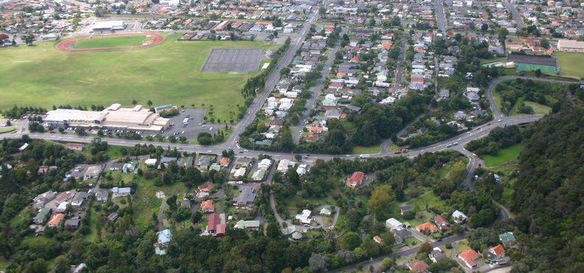
for SH1N Kensington Avenue to Manse Street Safety Improvements, Whangarei District
This NOR relates to widening, safety works and intersection improvements including the construction
of a roundabout, over a length of approximately 800m on SH 1 and 150m on the western end of
Kensington Avenue. On SH 1 the works start at a point 160m north of the Kensington Avenue/State
Highway 1 intersection and extend 220m south of the Manse Street/State Highway 1 intersection (refer
diagrams below).
The designation that applies to this portion of SH 1 is listed in Chapter 85 of the Whangarei District
Council Operative District Plan as “DTNZ 1 - State Highway 1 N Whangarei District Kaipara District
Boundary at the Brynderwyns to Whangarei District Far North Boundary at Hukerenui deleting Kamo
Road from DTNZ 3 up to Spring Flats”. The designation purpose is listed as “State Highway 1 N”. There
are no specific conditions detailed in the District Plan that relate to DTNZ 1.
The current traffic volume on this portion of SH 1 is estimated to be 22,580 vehicles per day with a 3%
annual growth rate (assumed for design). The existing layout creates a number of safety issues. In the
period 2009 to 2013 5 (inclusive) there were 48 accidents on this stretch of SH 1, consisting of:
i. 4 fatal;
ii. 3 serious injury;
iii. 18 minor injury; and
iv. 23 non-injury accidents.
5
Note: This period differs from the period over which the assessment was undertaken for the purposes of the
Project assessment (2006 – 2010 incl.). However the number of accidents over each 5 year period is similar, being
49 in the period 2006 – 2010, vs 48 in the period 2009 – 2013. However the severity of accidents has increased in
the latter period with fatal accidents increasing from 3 to 4, serious accidents staying the same at 3 and minor
injury accidents increasing from 8 to 18. In the period ’06 – ’10, 29% of accidents resulted in some form of injury
and this had increased to 52% in the period ’09 – ’13.
13NZ Transport Agency - NOR for Alteration of Designation
for SH1N Kensington Avenue to Manse Street Safety Improvements, Whangarei District
In March 2012 the New Zealand Government released its Safer Journeys - Road Safety Strategy, a
national strategy to guide improvements in road safety over the period 2010 - 2020. The strategy sets
out a long-term vision for New Zealand of 'a safe road system increasingly free of death and serious
injury'.
Safer Journeys introduces a Safe System approach to road safety to be implemented through a series
of action plans relating to the four key components of a Safe System:
i. Safe Roads and Roadsides;
ii. Safe Speeds;
iii. Safe Road Use; and
iv. Safe Vehicles.
A Safe System approach works on the principle that it is not acceptable for a road user to be killed or
seriously injured if they are involved in a crash and also acknowledges that road users are fallible and
will continue to make mistakes. A continuation of the traditional approach to road design is not
considered likely to achieve the desired gains in road safety in New Zealand. A Safe System approach
recognises the need for system designers and road users to share responsibility, with the ultimate aim
of protecting road users from death and serious injury.
The Safe System approach acknowledges four principles:
i. Human beings make mistakes and crashes are inevitable;
ii. The human body has a limited ability to withstand crash forces;
iii. System designers and road users must all share responsibility for managing crash forces to a
level that does not result in death or serious injury; and
iv. It will take a whole of system approach to implement the Safe System in New Zealand.
The Safer Corridors Strategy recommends roadside improvements and centreline treatments as being
effective measures e.g. curve warning signs, seal widening and Audio Tactile Profiled (ATP) markings.
The Safe Systems Transformation works include median barriers, roadside barriers and clear zones.
The assessment undertaken concludes that interventions must be made to improve this section of
Highway to address the safety concerns. It is proposed to redevelop this section of SH 1 to achieve the
following Project Objectives:
i. Improve the safety of the Manse Street intersection;
ii. Improve the safety of the State Highway between Kensington Ave and Manse Street;
iii. Improve the capacity and functionality of the Kensington Avenue intersection;
iv. Reduce the current crash rate;
v. Identify a safe solution for all road users, including pedestrians and cyclists; and
vi. To minimise any adverse effects on the environment or where this is not achievable adopt
6
means to mitigate.
The proposed improvements will result in a fundamental change to the State Highway operational
safety, with substantial improvements to the capacity of the Kensington Ave/SH 1 intersection,
including reducing the possible turning movements at the Russell Road/SH 1, Manse St/SH 1 and the
Kohatu Road/SH 1 intersections. These improvements are expected to consequentially reduce the
current crash rate.
To achieve the Project Objectives the improvements required include:
i. Installation of a roundabout at the Kensington Avenue/SH 1 intersection, which includes works
within Kensington Park and removal of existing car parking;
ii. Relocation of the intersection of Lower Stanley Street (private right-of-way) with SH 1;
iii. Removing the ability to undertake right turns in and out of Kohatu and Manse Streets;
6
NZ Transport Agency, Scheme Access Report, SH 1N – Kensington Ave to Manse Street Safety Improvements, May
2012, pg. 9, Attachment G.
14NZ Transport Agency - NOR for Alteration of Designation
for SH1N Kensington Avenue to Manse Street Safety Improvements, Whangarei District
iv. Creating a right-turn bay (southbound) for turning movements from SH 1 onto Russell Road
and removing the ability to undertake right-turn movements from Russell Road onto SH 1;
v. Establishing a raised median/guard rail between the Kensington Avenue/SH 1 intersection and
the existing median south of Manse Street, except for the right-turn bay at Russell Road and
the pedestrian walk-throughs to be established immediately south of the Kensington
Avenue/SH 1 intersection and the Russell Road/SH 1 intersection;
vi. Removal of a dwelling at 38 Powhiri Avenue; and
vii. Realignment of the SH 1/Powhiri Avenue pedestrian connection.
In addition works are to be undertaken including tree replanting and replacement of car parks in
Kensington Park. Some of these works are to be undertaken by WDC under agreement between WDC
and NZTA.
More specifically the proposed construction works associated with the alteration to designation
require:
i. Earthworks with a volume of approximately 12,417m3 (9,617m3 cut and 2,800m3 fill) over an
area of approximately 8,516m2 (0.85ha);
ii. Temporary drainage and sediment detention facilities associated with the earthworks;
iii. Installation of drainage facilities and stormwater control associated with the on-going
operation of the road;
iv. Vegetation removal and replanting;
v. Relocation of the Lower Stanley Street intersection with SH 1;
vi. Alterations to the: Lower Stanley Street/State Highway 1 intersection; the Kohatu Road/State
Highway 1 intersection; the Old Russell Road/State Highway 1 intersection; and the Manse
Street/State Highway 1 intersection;
vii. Establishment of new retaining structures;
viii. Establishment of new road pavement; and
ix. Relocation of services as necessary (including undergrounding).
Together these works make up “the Project”. The works required to establish the roundabout on the
intersection of Kensington Ave and State Highway 1 and other works proposed cannot be contained
within the boundaries of the existing designation. Therefore the designation boundaries need to be
amended. Further, the Project includes earthworks and drainage works which will extend beyond the
final designation boundary. These works are included in the consents sought from the Northland
Regional Council and the initial designation boundary will include these works and be realigned at a
later date to the area necessary for the operation of the State Highway.
1.3 Land Included in NOR Application
Sites from which land is required, adjoining State Highway 1 (SH 1) from 160 m North of the
Kensington Avenue/State Highway 1 intersection to 220 m south of the Manse Street/State Highway 1
intersection are detailed below. The references in the left-hand column correspond with references on
the plans included as Attachment D:
KENSINGTON AVE TO MANSE ST LAND REQUIRED
Plan Ref. Address Legal Description Area Req.
44 Kensington Avenue, Whangarei
1 (WDC, Kensington Park) Lot 1 DP 365614 2,420m²
2 38 Powhiri Avenue, Kensington Part Lot 13 DEEDS W 58 750m²
3 Powhiri Ave (WDC Road) Local Authority Roadway 204m²
4 47 Powhiri Avenue, Kensington Lot 1 DP 30269 (WDC Gaz). 375m²
21 4 Kohatu Road, Kensington Lot 2 DP 200472 20m²
22 6 Kohatu Road, Kensington Lot 3 DP 41738 95m²
28 209 Western Hills Drive, Kensington Lot 4 DP 18991 60m2
15NZ Transport Agency - NOR for Alteration of Designation
for SH1N Kensington Avenue to Manse Street Safety Improvements, Whangarei District
LOWER STANLEY ST LAND REQUIRED
11A 172 Western Hills Drive, Kensington Lot 1 DP 402603 30m²
12 170 Western Hills Drive, Kensington Lot 4 DP 70851 9m²
13 168 Western Hills Drive, Kensington Lot 3 DP 70851 9m²
14 166 Western Hills Drive, Kensington Lot 1 DP 177407 9m²
15 164 Western Hills Drive, Kensington Lot 1 DP 70851 9m²
16 162 Western Hills Drive, Kensington Lot 10 DP 37832 115m²
17 160 Western Hills Drive, Kensington Lot 9 DP37832 127m²
18 158 Western Hills Drive, Kensington Lot 8 DP 37832 22m²
TOTAL 4,254m²
It is noted that Lower Stanley St is already part of the NZTA road reserve, but outside of the current
designation boundary. The land purchased for alterations to Lower Stanley Street will be ‘road to vest’
and become part of the new designated SH1 (refer Attachment A). The street names and property
addresses are not intended to change.
The amendments to Lower Stanley Street may require the cancellation of existing easements. Crown
Property Services (NZTA’s property acquisition agent) advises that cancellation of easements happens
by Gazette notice as part of the land becoming road during the land purchase process.
Notwithstanding, if specific and/or individual cancellations are required under s243 RMA then formal
applications for such shall be made at the appropriate time.
Sites for which land entry is required to undertake construction works, adjoining SH 1 from 160 m
North of the Kensington Avenue/State Highway 1 intersection to 220 m south of the Manse
Street/State Highway 1 intersection. The references in the left-hand column correspond with
references on the plans included as Attachment C:
KENSINGTON AVE TO MANSE ST TEMPORARY OCCUPATION
Plan Ref. Address Legal Description Area
44 Kensington Avenue, Whangarei
1a (WDC, Kensington Park) Lot 1 DP 365614 2,037m²
3a Powhiri Ave (WDC Road) Local Authority Roadway 122m²
4a 47 Powhiri Avenue, Kensington Lot 1 DP 30269 (WDC) Gaz. 140m²
6 206 Western Hills Drive, Kensington Lot 1 DP 170670 124m²
8 178 Western Hills Drive, Kensington Lot 1 DP 169630 11m²
9 176 Western Hills Drive, Kensington Lot 1 DP 45524 11m²
10 174 Western Hills Drive, Kensington Lot 12 DP 37832 15m²
16a 162 Western Hills Drive, Kensington Lot 10 DP 37832 21m²
17a 160 Western Hills Drive, Kensington Lot 9 DP 37832 16m²
18a 158 Western Hills Drive, Kensington Lot 8 DP 37832 21m²
19 156 Western Hills Drive, Kensington Lot 7 DP 37832 16m²
21a 4 Kohatu Road, Kensington Lot 2 DP 200472 25m²
22a 6 Kohatu Road, Kensington Lot 3 DP 41738 52m²
23a 207 Western Hills Drive, Kensington Lot 4 DP 41738 85m²
24 87 Western Hills Drive, Kensington Lot 44 Deeds 721 761m2
25 154 Western Hills Drive, Kensington Lot 2 DP 128600 13m²
16NZ Transport Agency - NOR for Alteration of Designation
for SH1N Kensington Avenue to Manse Street Safety Improvements, Whangarei District
154A Western Hills Drive,
26 Kensington Lot 1 DP 128600 11m²
27 152 Western Hills Drive, Kensington Lot 5 DP 37832 18m²
28a 209 Western Hills Drive, Kensington Lot 4 DP 18991 260m2
TOTAL 3,759m²
In addition, the Notice of Requirement process will include the expansion of the current
designation boundary to properly accommodate the existing State Highway corridor. The
plans included in Attachment A show where the existing corridor, while being located on land
owned by NZTA, is not all currently subject to the State Highway Designation. There are also
areas of WDC owned land currently used for road that will be included in the designation
boundary. By expanding the area of the designation to include the entire corridor enables the
corridor to be managed in accordance with the conditions of the designation. Those areas of
land currently owned by NZTA and WDC and either used for Highway or road to be included in
the amended designation are shown on the plan included as Attachment Da and are detailed
in the schedule below:
NZTA AND WDC LAND TO BE INCLUDED IN DESIGNATION
Plan Ref. Address Legal Description Area
Lower Stanley Street,
A NZTA Road Reserve - 2,027m²
Kensington Avenue,
B NZTA Road Reserve - 344m²
Kensington Avenue,
C* WDC Road Reserve - 3,142m²
D NZTA Road Reserve - 1,772m²
Kohatu Street,
E NZTA Road Reserve - 72m²
F NZTA Road Reserve - 107m²
Russell Road,
G* WDC Road Reserve Lot 1 DP 30982 584m²
H NZTA Road Reserve - 706m²
Manse Street,
I NZTA Road Reserve - 12,234m²
TOTAL 20,988m²
* The designation will be uplifted from these areas in whole or in part on the completion of
the works.
Additional to the above, works are required within Kensington Park to relocate car parking and trees as
a result of some of the works proposed extending into the Park. Some of these works will be
undertaken by WDC rather than NZTA through an agreement between the two parties.
Land compensation negotiations are continuing between WDC and NZTA’s agents Crown Property
Services. As part of this process Kensington Park lessees are being consulted. Evidence of the stage
of these consultations and the assessment of tree relocation is included in the attached email
(Attachment Qa). Consultation over the effect on Kensington Park has been ongoing and NZTA
submitted on the recent Kensington Park Management Plan review. The resulting Management Plan
includes the proposed works.
Included as mitigation works is the conversion of 87 Western Hills Drive, Kensington (Lot 44 Deeds
721, 761m²) (shown as # 24 on Attachment C) into car parking to serve Kensington Park. NZTA will
undertake this work as part of the extent of works, but not part of the proposed permanent
designation. When completed it is intended to vest this site as recreation reserve, becoming an
addition to Kensington Park.
17NZ Transport Agency - NOR for Alteration of Designation
for SH1N Kensington Avenue to Manse Street Safety Improvements, Whangarei District
1.4 Resource Consents
Land use consent is being applied for from the Whangarei District Council related to potential
contaminants in soil as the earthworks required include an area in the south-western corner of
Kensington Park where 3,430 m³ of earthworks is proposed for the required new roundabout and
adjustments to the alignment of SH 1 and Kensington Avenue to link to the new roundabout. This area
of land is considered to be potentially contaminated in accordance with Item 10 of the Hazardous
Activities and Industries List (HAIL) (October 2011) being land subject to “Persistent pesticide … use
including sport turfs …” Land use consent is required because a detailed site investigation has not
been undertaken.
An application is also being made contemporaneously to the Northland Regional Council for resource
consents for earthworks and discharge.
18NZ Transport Agency - NOR for Alteration of Designation
for SH1N Kensington Avenue to Manse Street Safety Improvements, Whangarei District
2. NZTA Framework
2.1 Legislative Framework
The NZTA’s statutory objective is defined in the Land Transport Management Act 2003 (LTMA) “to
undertake its functions in a way that contributes to an effective, efficient, and safe land transport
system in the public interest.” 7
Relevant functions of the NZTA include:
i. To contribute to an effective, efficient, and safe land transport system in the public interest;
ii. To manage the State Highway system, including planning, funding, design, supervision,
construction, and maintenance and operations, in accordance with the LTMA and the
Government Roading Powers Act 1989;
iii. To assist, advise, and co-operate with approved organisations. 8
There are a number of documents that NZTA must consider, take guidance from and give effect to
when undertaking a project such as this and these are summarised below.
2.2 Connecting New Zealand
In 2011, the Government published Connecting New Zealand – a summary of the government's policy
direction for transport.
Connecting New Zealand covers the period 2011 - 2021. The Government has indicated that while it
still supports the intent of the NZ Transport Strategy 2008, Connecting New Zealand provides a more
"current summary of the government's transport policy and intentions". The document sets out the
Government's objective of:
"an effective, efficient, safe, secure, accessible and resilient transport system that supports the
growth of our country's economy, in order to deliver greater prosperity, security and
opportunity for all New Zealanders".
In order to deliver this objective, the Government has identified three areas of focus across the
transport system:
i. Economic growth and productivity;
ii. Value for money; and
iii. Road safety.
2.3 Government Policy Statement on Land Transport
Funding
The Government Policy Statement (GPS) on Land Transport Funding was published in July 2011 for the
period 2012/2013 – 2021/2022. The purpose of the GPS is to detail the Government’s desired
outcomes and funding priorities for the land transport sector.
The GPS outlines central governments expectations from the funding made available through the
National Land Transport Programme (NLTP). Regional Land Transport Plans must be consistent with
7
Section 94 LTMA, as amended by the LTMAA.
8
Section 95 LTMA, as amended by the LTMAA.
19NZ Transport Agency - NOR for Alteration of Designation
for SH1N Kensington Avenue to Manse Street Safety Improvements, Whangarei District
the GPS and land transport activities delivered by the NZTA and local government are funded from the
National Land Transport Fund (NLTF).
The emphasis of the current GPS is to invest in land transport infrastructure to increase economic
growth and productivity in New Zealand. The specific outcomes the Government expects to be
achieved through the use of the NLTF are:
• Improvements in the provision of infrastructure and services that enhance transport efficiency
and lower the cost of transportation through:
• Improvements in journey time reliability;
• Easing of severe congestion;
• More efficient freight supply chains;
• Better use of existing transport capacity.
• Better access to markets, employment and areas that contribute to economic growth.
• A secure and resilient transport network.
• Reduction in deaths and serious injury as a result of road crashes.
• More transport choices, particularly for those with limited access to a car.
• Reductions in adverse environmental effects from land transport.
• Contributions to positive health outcomes. 9
Future funding for transportation projects is assessed by the funding arm of the NZTA against these
GPS criteria.
The NLTP is the NZTA’s approved list of projects, which was founded on the Regional Land Transport
Committee's prioritisation of preferred projects. This Project is listed as a priority project in the
2012/15 Regional Land Transport Programme.
2.4 NZTA Environment and Social Responsibility Policy
Section 96 of the LTMA details the ‘operating principles’ the NZTA must adhere to in meeting its
objectives and undertaking its functions. Specifically, s 96(1)(a) of the LTMA requires the NZTA to
exhibit a sense of social and environmental responsibility. The NZTA promotes an accessible and safe
transport system that contributes positively to New Zealand’s economic, social and environmental
welfare and are committed to acting in an environmentally and socially responsible manner.
In particular the NZTA are committed to:
i. Protecting and enhancing the natural, cultural and built environment;
ii. Enhancing the quality of life for New Zealanders by improving community liveability including
land transport safety;
iii. Taking appropriate account of the principles of the Treaty of Waitangi;
iv. Providing meaningful and transparent engagement with stakeholders, customers and the
general public; and
v. Providing customer focused services that are fair, trusted and efficient.
To implement the Environment and Social Responsibility Policy the NZTA will:
i. Promote the safe and efficient movement of goods and people in a manner that avoids, to the
extent reasonable in the circumstances, adverse environmental and social impacts;
ii. Continuously improve performance in the management of environmental and social impacts;
iii. Integrate good urban design into all their activities;
iv. Work to improve knowledge and understanding of the extent and condition of New Zealand’s
environmental and cultural heritage assets;
v. Maintain and improve opportunities for Maori to contribute to decision-making processes;
vi. Actively and meaningfully engage with affected and interested persons and organisations;
9
Government Policy Statement on Land Transport Funding 2012/13 – 2021/22, July 2011, pg. 7.
20NZ Transport Agency - NOR for Alteration of Designation
for SH1N Kensington Avenue to Manse Street Safety Improvements, Whangarei District
vii. Identify and comply with all relevant environmental and social legislation and regulations;
viii. Seek whole-of-life value for money by taking into account environmental and social costs and
benefits when procuring goods and services; and
ix. Provide employees with the skills, awareness and leadership to achieve environmental and
social objectives.
2.5 Safer Journeys
In March 2012 the New Zealand Government released its Safer Journeys - Road Safety Strategy, a
national strategy to guide improvements in road safety over the period 2010 - 2020. The strategy sets
out a long-term vision for New Zealand of 'a safe road system increasingly free of death and serious
injury' (see section 1.2 for more detail).
2.6 Regional Land Transport Strategy
The Northland Regional Council ‘30 Year Transport Strategy for Northland’ 2010 – 2014 (operative 31
May 2010), incorporates the Regional Land Transport Strategy (RLTS) and sets the direction for the
Region's transport system over the next 30 years. The Strategy identifies what is required to achieve
an affordable, integrated, safe, responsive, and sustainable transport system. The "preferred strategic
direction" is:
to focus on investment decisions in roading, passenger transport, travel demand management
and improvements in the rail network that will support proposed land use changes, economic
growth and productivity and promote inter-regional connections as a way of connecting the
Northland region with the rest of the country.
The Vision of the Strategy for Northland is that "People and freight … have access to an affordable,
integrated, safe, responsive and sustainable transport system". The document places emphasis on
economic success. The outcomes sought are:
• A sustainable transport system that supports the growth and existing economic development
of Northland and New Zealand
• All road users are safe on Northland's roads
• Northland is well connected to Auckland and to the rest of New Zealand
• Northland's roading network is developed and maintained so that it is fit for purpose
• Efficient and integrated multi-modal movement of freight with less impact on the roading
network and the environment
• Our people have transport choices to access jobs, recreation and community facilities
• The transport system enhances the environmental and cultural values of Northland
• Effective ports servicing Northland and New Zealand
The Strategy details National Challenges and the associated Regional Challenges as being:
National Challenges Regional Challenges
Journey time reliability Economic success, route security and connecting communities:
focus is primarily on the journey time along the strategic
tourism route (Bay of Islands to Auckland) but also recognises
journey time reliability for freight and for people to access
markets and employment within the Region.
Severe congestion Economic success and better integration of land use and
transport: particularly focused on the Whangarei urban area for
current congestion issues but also a key challenge is ensuring
future land use and development decisions do not result in
21You can also read