THE RICHARDS-FOLLETT-PFAFF STABLES - Boston Landmarks Commission Study Report - Petition #267.20 Boston Landmarks Commission Environment ...
←
→
Page content transcription
If your browser does not render page correctly, please read the page content below
THE RICHARDS-FOLLETT-PFAFF STABLES
        Boston Landmarks Commission
                 Study Report

.

                                         Petition #267.20
                            Boston Landmarks Commission
                                 Environment Department
                                           City of Boston

                                   Report template version July 22, 2021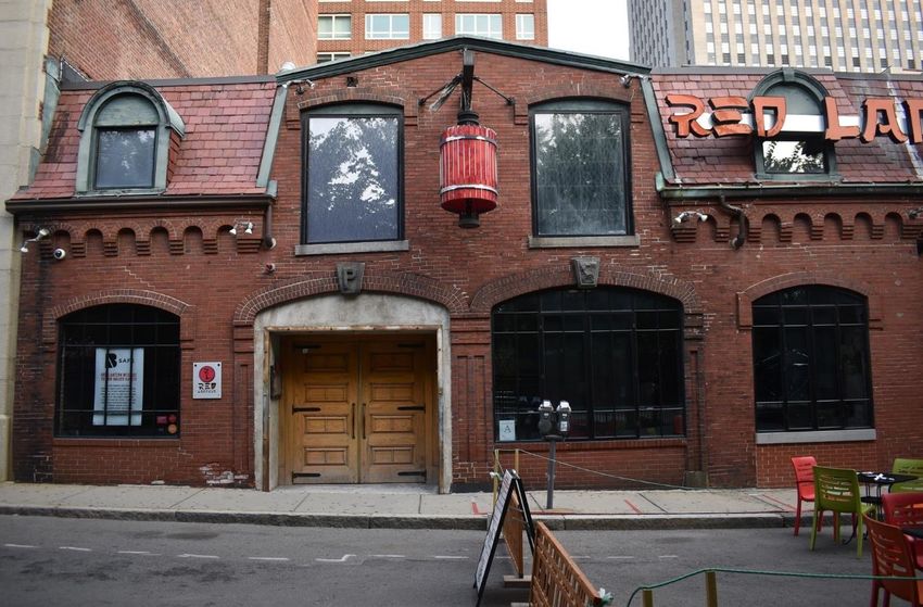
Report on the Potential Designation of

                               The Richards-Follett-Pfaff Stables
                           39 Stanhope Street, Boston, Massachusetts

                    As a Landmark Chapter 772 of the Acts of 1975, as amended

Approved by:

                                           Rosanne Foley, Executive Director                          Date

Approved by:

                                           Lynn Smiledge, Chair                                       Date

Draft report posted on September 7, 2021
.

                                                                        Report template version July 22, 2021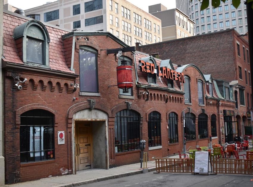
Table of Contents
INTRODUCTION                                                                                          i

1.0 LOCATION                                                                                         3
  1.1 Address                                                                                        3
  1.2 Assessor’s Parcel Number                                                                       3
  1.4 Map Showing Location                                                                           3

2.0 DESCRIPTION                                                                                     4
  2.1 Type and Use                                                                                  4
  2.2 Physical Description of the Resource                                                          4
  2.3 Contemporary Images                                                                           7

3.0 SIGNIFICANCE                                                                                   16
  3.1 Historic Significance                                                                         17
  3.2 Architectural (or Other) Significance                                                        23
  3.3 Archaeological Sensitivity                                                                   25
  3.4 Relationship to Criteria for Designation                                                     26

4.0 ECONOMIC STATUS                                                                                27
  4.1 Current Assessed Value                                                                       27
  4.2 Current Ownership                                                                            27

5.0 PLANNING CONTEXT                                                                               28
  5.1 Background                                                                                   28
  5.2 Zoning                                                                                       28
  5.3 Planning Issues                                                                              28

6.0 ALTERNATIVE APPROACHES                                                                         29
  6.1 Alternatives available to the Boston Landmarks Commission                                    29
  6.2 Impact of alternatives                                                                       29

7.0 RECOMMENDATIONS                                                                                 31

8.0 STANDARDS AND CRITERIA, WITH LIST OF CHARACTER-DEFINING FEATURES                               32
  8.1 Introduction                                                                                 32
  8.2 Levels of Review                                                                             32
  8.3 Standards and Criteria                                                                       34
  8.4 List of Character-defining Features                                                          47

9.0 ARCHAEOLOGY                                                                                    49

10.0 SEVERABILITY                                                                                  50

11.0 BIBLIOGRAPHY                                                                                   51

                                                                  Report template version July 22, 2021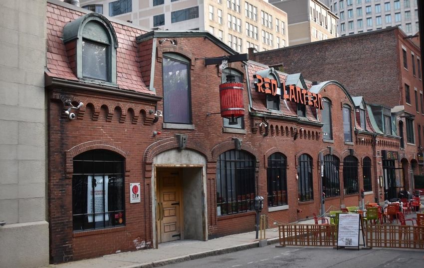
INTRODUCTION

The designation of the Richards-Follett-Pfaff Stables (commonly known as the Stanhope Street
Stables) was initiated in 2020 after a petition was submitted by registered voters to the Boston
Landmarks Commission asking that the Commission designate the property under the provisions of
Chapter 772 of the Acts of 1975, as amended. The purpose of such a designation is to recognize and
protect a physical feature or improvement which in whole or part has historical, cultural, social,
architectural, or aesthetic significance.

The Stables are eligible for designation as a Boston Landmark for their combined historical and
architectural significance to the city and to the state. They are the earliest surviving block of stables
related to the development of Boston’s Back Bay neighborhood, and their location epitomizes an
important early trend in urban planning to locate stables away from upscale residences and
construct them of fireproof materials, even before such requirements were in place. The placement
of the Stables close to two major railroads facilitated travel for the owners, who were typically
prominent businessmen and industrialists, Back Bay residents, and known not only in Boston but
also regionally and nationally. The Stables also represent an important stage in the development of
urban transportation, as Boston first relied on horse-drawn vehicles and personal horses before
transitioning to automobiles. The physical exterior fabric represents these changes in use as the
stables were adapted to suit the evolving needs of the community. The Stables are a rare surviving
example of a Panel Brick-style stable, one of only a few known in the state. The Stables signal the
beginning of a broad stylistic shift in architectural design from the academic Second Empire style to
the picturesque Panel Brick style that occurred within the progressive urban center of Boston and
then characterized new design aesthetics throughout the state. As the design of noted and prolific
Boston-based and regional architect Nathaniel J. Bradlee, the Stanhope Street Stables are a rare
example of one of his works interpreting an emerging stylistic vocabulary in a utilitarian building.
They are also important as one of Bradlee's works constructed before the Boston Fire of 1872, which
destroyed many of his earliest buildings. Bradlee designed more than 500 buildings in central
Boston, the greater Boston area, and beyond.

This study report contains Standards and Criteria which have been prepared to guide future
physical changes to the property in order to protect its integrity and character.

Boston Landmarks Commission

Lynn Smiledge, Chair
John Amodeo
David Berarducci
Joseph Castro
John Freeman
Susan Goganian
Jeffrey Gonyeau
Christopher Hart
Richard Henderson

                                                                           Report template version July 22, 2021
                                                                                                             p. i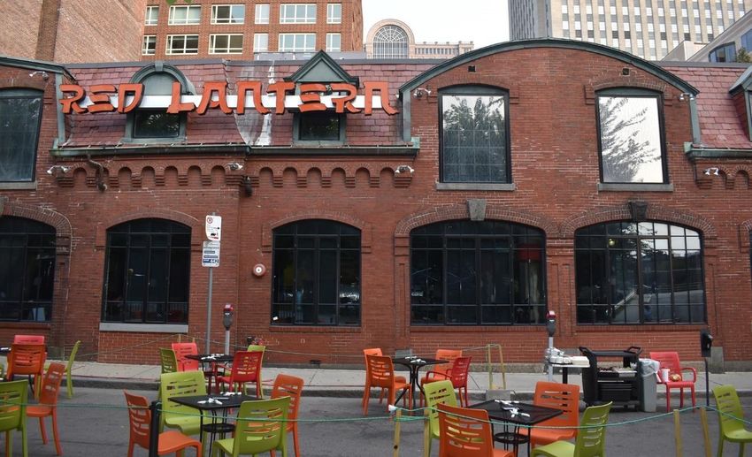
Kirsten Hoffman
Thomas Hotaling
Felicia Jacques
Lindsey Mac-Jones
Justine Orlando
Diana Parcon
Anne Renehan
Brad Walker

Staff

Rosanne Foley, Executive Director
Kathleen von Jena, Assistant Survey Director
Yolanda Romero, Staff Architect
Joe Bagley, City Archaeologist
Jennifer Gaugler, Architectural Historian

Consultant for preparation of initial report

The Public Archaeology Laboratory, Inc.

                                               Report template version updated 7/22/2021
                                                                                     p. ii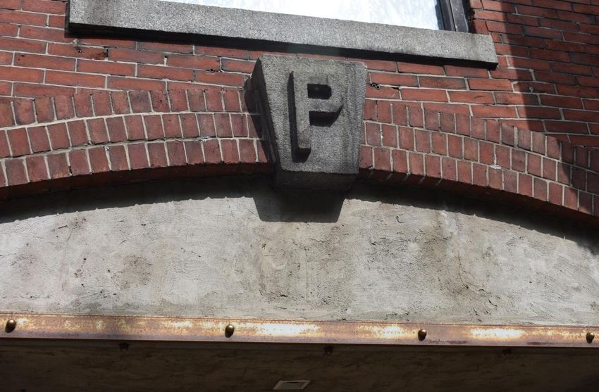
1.0   LOCATION

1.1   Address

      According to the City of Boston’s Assessing Department, the Richard-Follett-Pfaff Stables
      (commonly known as Stanhope Street Stables) are located at 39 Stanhope Street, Boston,
      Massachusetts, 02116. (The Stables are listed in MACRIS as #s 39, 41, 43, & 45 Stanhope
      Street.)

1.2   Assessor’s Parcel Number

      0401126000.

1.3   Area in which Property is Located
      The Stanhope Street Stables are in the Park Square-Stuart Street Area (BOS.ZF), bounded by
      131 Clarendon Street to the west, Stanhope Street/Alley 559 to the north, 35–37 Stanhope
      Street to the east, and Stanhope Street to the south.

1.4   Map Showing Location

      Parcel Map showing the location of parcel 0401126000 within the surrounding area.

                                                                       Report template version 7/22/2021
                                                                                                     p. 3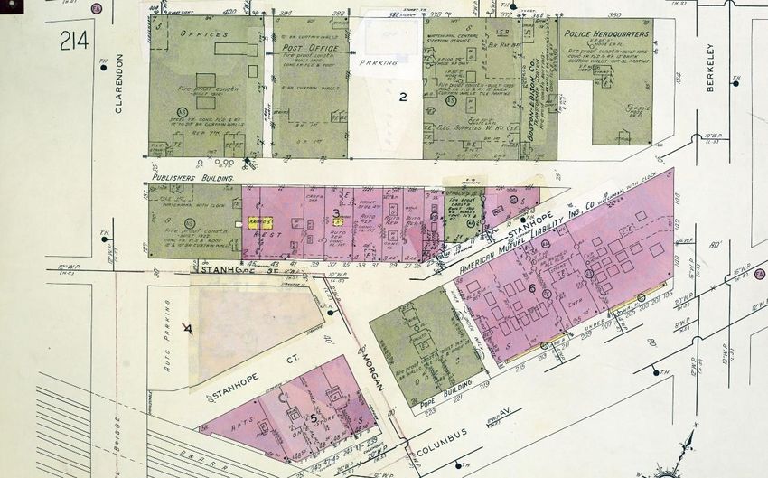
2.0      DESCRIPTION

2.1      Type and Use

         The Richards-Follett-Pfaff Stables (also known as the Stanhope Street Stables) at 39
         Stanhope Street, Boston, Massachusetts (listed in MACRIS as #s 39, 41, 43, & 45 Stanhope
                          1
         Street, BOS.2390) is in the Boston Zoning Code Stuart Street District, sub-district type
         Mixed Use Area 3, near the Back Bay and directly adjacent to the historic Bay Village and
                                  2
         South End neighborhoods. The building was originally constructed for use as private stables
         in 1868–1869 and has had several subsequent uses since the early 20th century, including as
         a garage and commercial space, and then as a series of restaurants. The building is currently
         used as a restaurant.

2.2      Physical Description of the Resource

         The Richards-Follett-Pfaff Stables (also known as the Stanhope Street Stables) at 39
         Stanhope Street, Boston, Massachusetts (in MACRIS as #s 39, 41, 43, & 45 Stanhope Street,
         BOS.2390) consists of a row of four continuous south-facing masonry stables (Photos 1–10).
         The property is in the Park Square-Stuart Street Area (BOS.ZF) bounded by the
                                                                                                    3
         neighborhoods of the Back Bay (north and west), Bay Village (east), and South End (south).
         Constructed in 1868–1869, it was designed by prolific Boston architect Nathanial Jeremiah
         Bradlee (1824–1888) in the Panel Brick style with elements of the Second Empire style. The
         building occupies the entirety of an urban rectangular lot bound by a party-wall, eight-story
         building to the west; Stanhope Street to the south; a party-wall, one-and-one-half-story
         building to the east; and Stanhope Street/Alley 559 to the north. Originally, 39–45 Stanhope
         Street was built as the west half of eight contiguous stables (Figures 1–4). The east half now
         consists (west to east) of the abutting one-story, two-bay unit building and three, four-story
                                                                           th
         buildings constructed above the stables at the turn of the 20 century that retain some
         elements of the former stables, such as first floor carriage openings and second floor
                                                                                   4
         windows. A concrete sidewalk abuts the building on the south and north.

         The eight-bay-wide building rises one-and-one-half stories, and walls are constructed of
         red brick laid in a running bond. Portions of the granite foundation and granite blocks at
         former carriage bay openings are present on the south side at the east end; at the west end,
         brick rises from the sidewalk. Small areas of concrete low foundation infill are present where
         door openings have been filled in for windows. The building’s facade (south) is arranged in
         two primary west and east four-bay elements, and the west half of the building projects
         slightly from the east half (note: bays in this following section are counted from the west

1
  The four former stables at 39, 41, 43, and 45 Stanhope Street were connected after 1916; they occupy one lot at 39
Stanhope Street. The description section of this report discusses the four stables as one building; the historical
significance section details the history of each stable and places the building block within a larger context.
2
  See http://maps.bostonplans.org/zoningviewer/.
3
  Back Bay (BOS.BT) was listed in the National Register of Historic Places (NR) in 1973 (73001948) and
designated a Boston Landmark Architectural District in 1966; expanded in 1974, 1979, and 1981; South End
(BOS.AC) was NR listed in 1973 (73000324) and designated a Boston Landmark District in 1982; Bay Village
(BOS.BQ) was designated a Boston Landmark Historic District in 1983.
4
  The Landmark application for 39 Stanhope Street is for the exterior only; the interior is not included.

                                                                                     Report template version 7/22/2021
                                                                                                                   p. 4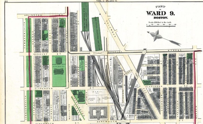
end) (Photos 1–4). The facade terminates at a flared mansard roof sheathed in red slate
shingles above a Panel Brick-style, robust, scalloped, corbelled cornice and metal gutters
(Photo 5). The west half contains a central two-bay, gambrel-roof wall dormer pavilion
flanked by round-arch roof dormers; the east half has a central two-bay, segmental-arch-
roof wall dormer pavilion flanked by gable-roof dormers. Dormers have molded copper
coping and walls clad in red slate shingles. The dormers vary slightly with arch-roof dormers
having painted plywood pediments and gable-roof dormers having copper or painted sheet
metal pediments (Photo 6). The arch-roof dormer in the fourth bay has a keystone motif, and
the gable roof dormer in the fifth bay has a flared pediment. Wall dormer window openings
have protruding segmental-arch brick window hoods with side labels and smooth granite
sills. Remnants of sawn-off wood hayloft beams are evident above three of the wall dormers
windows; the fourth appears to have been bricked in. The west wall dormer contains a
central, metal beam supporting a hanging red lantern. A florescent sign spelling “Red
Lantern” is attached to fronts of the dormers at the fourth and fifth bays.

As originally designed, the first story in the west and east halves each contained two
abutting carriage entrances in the pavilion bays, three of which are now window openings,
flanked by windows (Photo 7, Figure 5). The former entrances are framed by brick surrounds
with paneled pilasters and corbelled segmental arches with granite keystones (Photo 8). The
keystone in the second bay contains a bas-relief “P,” referencing the stable’s early owner,
Jacob Pfaff; keystones in the third and seventh bays have smooth faces with stepped rough-
cut edges (Photo 9). The keystone in the sixth bay has an irregular rough surface that
suggests it may have had a projecting carving that has been removed. Currently, the primary
entrance is in the second bay from the west end; it is recessed in the brick opening and
contains paired, four-panel, wood doors with strap hinges (Photo 7). The other three former
carriage entrances have been infilled with red brick at the bottom to create windows with
row lock brick sills. The four original window bay openings flanking the pavilions are
segmental-arch openings with protruding hoods with side labels. All windows have rowlock
brick sills except two in the fourth and eight bays, which have smooth granite sills.
Fenestration consists of multi-light black aluminum windows with casement windows in the
first story and fixed vinyl one-light sashes at the second story dormers (see Photo 5). The
rear (north) elevation is 12 bays wide, constructed of red brick (now painted and unpainted)
laid in a running-bond (Photo 10). A shallow stepped brick cornice runs along the edge of the
flat roof. Four tie-bolts with metal star plates are present between the two stories. The first
story consists of evenly spaced openings with two entrances and ten brick-infilled door or
window openings. Openings have segmental arches; all second story openings and four first
story openings have granite sills. Second story openings are evenly spaced and have painted
granite lintels and sills. Openings are filled with plywood, painted brick, or fixed windows.
Wide, deep granite curbstone blocks line the street edge of the concrete sidewalk that abuts
the rear elevation.

Since the building was constructed in 1868–1869, limited alterations have occurred largely
due to changes in use and partially due to fire damage. Exterior changes are primarily to
roof-top elements, window sash, doors, and filling of the lower portion of doorways. The
1866 Bradlee architectural drawings show a rhythm of door and window openings that
remains, with some modifications within individual openings, today. Comparison of the

                                                                  Report template version 7/22/2021
                                                                                                p. 5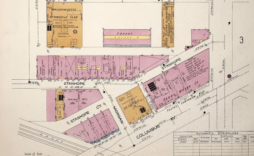
drawings with historic photographs and current conditions show that some of the as-built
        details diverged from the drawings. First-floor carriage bay doors are depicted as large
        paneled doors in segmental-arch openings that remain; three have been converted to single
        windows with brick infill to the height of the window sill. The first story window openings
        are shown in the drawings with paired windows divided by brick with four-over-four arch-
        topped sash; these are now single segmental-arch windows (see Figure 5). The roof dormers
        were different shapes, with the west end dormers having a flared gable roof and the east end
        dormers having a round-arch roof; these remain today as built (but reversed from the
        drawing). The second story hayloft openings of the wall dormers were shown as filled with
        double-leaf glazed doors in flat-top openings. Currently, and likely as built, the openings are
        segmental arch, now filled with fixed sash windows. Two low, eight-bay-wide, hip-roof
        cupolas with arch-top four-light windows and central roof ventilators, and three paneled
        and corbelled brick chimneys, rose from the roof. These elements are not extant.
        Photographs from 1955 and 1957 show that the alterations, including removal of the cupolas,
        chimneys, carriage entrance doors, and window sash, had occurred by this time (see Figures
        5 and 6). The east ventilator was removed by 1937, and the west ventilator was removed
                                                      5
        between 1951 and 1957 (see Figures 4 and 6). The drawings depict the rear of the building as
        designed consisting only of window openings on three levels, including windows at the
        basement level which are not visible today (see Figure 5). The windows were most likely
        below grade and served by a lightwell where the concrete sidewalk is now. These changes
                                                   th
        also likely occurred in the early to mid-20 century.

5
 Sanborn Map & Publishing Co, Insurance Maps of Boston, MA, Volume 2, 1937, Sheet 215 (Sanborn Map &
Publishing Co., 1937); Sanborn Map & Publishing Co, Insurance Maps of Boston, MA, Volume 2, 1951, Sheet 215
(Sanborn Map & Publishing Co., 1951).

                                                                               Report template version 7/22/2021
                                                                                                             p. 6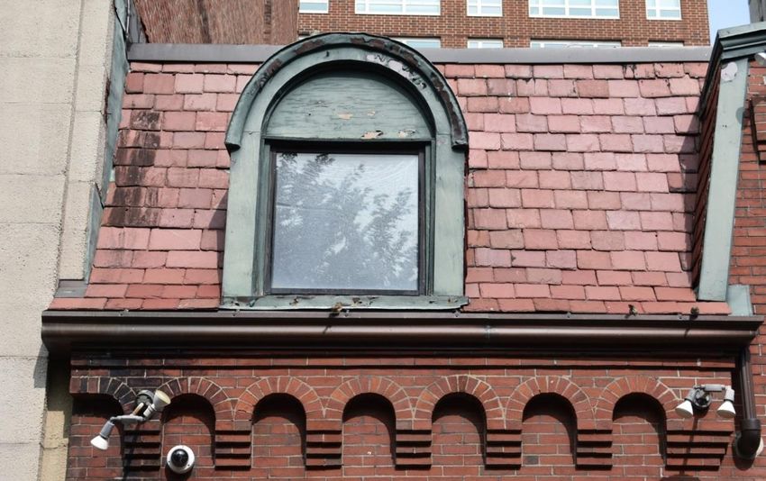
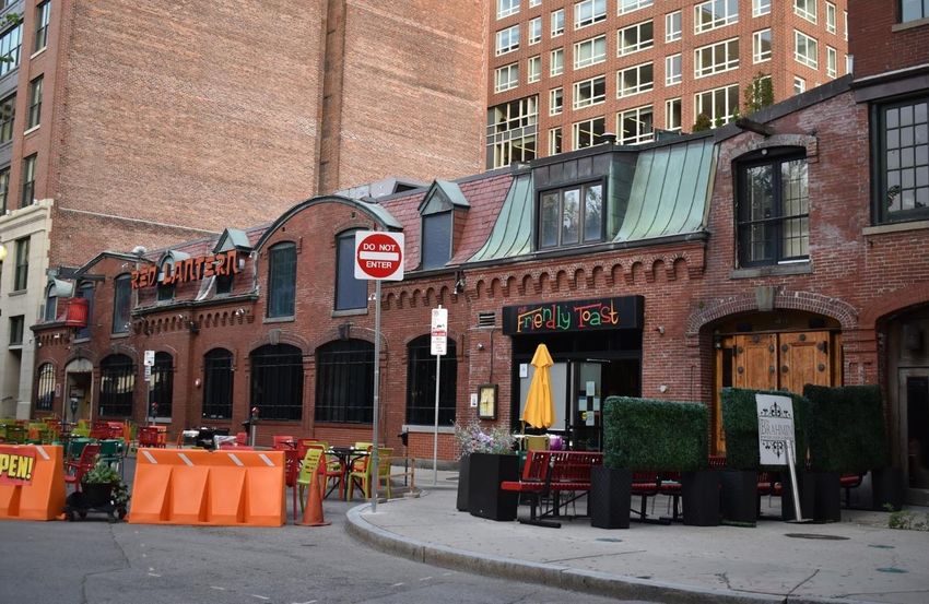
2.3   Contemporary Images

      Photo 1. 39–45 Stanhope Street facade (south elevation), looking northeast.

      Photo 2. 39–45 Stanhope Street facade, looking northwest.

                                                                        Report template version 7/22/2021
                                                                                                      p. 7
Photo 3. East half of 39–45 Stanhope Street facade, looking north.
Photo 4. West half of 39–45 Stanhope Street facade, looking north/northwest.
Report template version 7/22/2021
p. 8Photo 5. Window detail, west half of 39–45 Stanhope Street facade (first bay), looking
north/northwest.
Photo 6. Detail of arched roof dormer, slate shingle Mansard roof, and corbeled cornice (west-
half).
Report template version 7/22/2021
p. 9Photo 7. Detail of double carriage entrance, west half of 39–45 Stanhope Street facade,
looking north/northwest.
Photo 8. Detail of brick pilaster indicative of Panel Brick style and granite base blocks at
carriage bays.
Report template version 7/22/2021
p. 10Photo 9. Detail of granite “P” keystone in the second bay (west half).
Photo 10. 39–45 Stanhope Street rear elevation, looking east.
Report template version 7/22/2021
p. 112.4 Historic Maps and Images
Figure 1. Hopkins 1874 Map depicts the Stanhope Street Stables (in blue) and the Park
6
Square Area.
Figure 2. Bromley 1883 map depicting the Stanhope Street Stables and the Boston and
7
Providence Railroad Freight Shed to the north.
6
G.M. Hopkins & Co, Atlas of the County of Suffolk, Massachusetts, Boston 1874, Plate T, Back Bay (Philadelphia:
G.M. Hopkins & Co, 1874).
7
G.W. Bromley & Co, Atlas of the City of Boston : City Proper : Volume 1, Sheet 10L Plate J, Back Bay
(Philadelphia: G.W. Bromley & Co, 1883).
Report template version 7/22/2021
p. 12Figure 3. 1914 Sanborn Map depicting Stanhope Street and new development to the north and
8
southeast.
9
Figure 4. 1951 Sanborn Map depicting Stanhope Street and new development to the north.
8
Sanborn Map & Publishing Co, Insurance Maps of Boston, MA, Volume 2, 1914, Sheet 11 (Sanborn Map
& Publishing Co., 1914).
9
Sanborn Map & Publishing Co, Insurance Maps of Boston, MA, Volume 2, 1951, Sheet 215 (Sanborn
Map & Publishing Co., 1951).
Report template version 7/22/2021
p. 13Figure 5. 1866 Drawing by Nathaniel J. Bradlee of the Front Elevation and Rear Elevation of
10
Eight Stables, on file at Boston Athenaeum.
10
N.J. Bradlee Archives, “Architectural Drawings from N.J. Bradlee (1853–1871) and Bradlee & Winslow
(1872–1875),” on file at The Boston Athenaeum, Boston, MA.
Report template version 7/22/2021
p. 14Figure 6. 1957 Photograph of 39–45 and 35–37 Stanhope Street by Nishan Bichajian (cropped),
11
showing the Red Coach Grill restaurant (on file MIT Libraries).
11
Nishan Bichajian, “Parking Lot, Red Coach Grill Restaurant in Middle Distance, between Columbus Avenue and
Stanhope Street,” on file with MIT Libraries (1957).
Report template version 7/22/2021
p. 153.0 SIGNIFICANCE
The Richards-Follett-Pfaff Stables (also known as the Stanhope Street Stables) at 39
Stanhope Street, Boston, Massachusetts, (listed in MACRIS as #s 39, 41, 43, & 45 Stanhope
12
Street, BOS.2390) consist of four of what was originally 13 connected stables. The Stables
13
were built on Stanhope Street in 1868–1869. They are eligible for designation as a Boston
Landmark for their combined historical and architectural significance to the city and to the
state. They are the earliest surviving block of stables related to the development of Boston’s
Back Bay neighborhood, and their location epitomizes an important early trend in urban
planning to locate stables away from upscale residences and construct them of fireproof
materials, even before such requirements were in place. Leading Back Bay real estate
developer and investor Frank W. Andrews and prominent Massachusetts businessperson and
industrialist Royal E. Robbins, both Back Bay residents, financed and developed the Stables
for personal use and investment. The placement of the Stables close to two major railroads
facilitated travel for the owners, who were typically prominent businessmen and
industrialists, Back Bay residents, and known not only in Boston but also regionally and
nationally. The Stables also represent an important stage in the development of urban
transportation, as Boston first relied on horse-drawn vehicles and personal horses before
transitioning to automobiles. The physical exterior fabric represents these changes in use as
the stables were adapted to suit the evolving needs of the community.
Architecturally, the Stables are an excellent, very early if not the earliest, and rare surviving
example of a Panel Brick-style stable, one of only a few known in the state. The Stables are
among a small number in this group intended for private residential use. Other Panel Brick-
style stables identified are later and larger. The Stables signal the beginning of a broad
stylistic shift in architectural design from the academic Second Empire style to the
picturesque Panel Brick style that occurred within the progressive urban center of Boston
and then characterized new design aesthetics throughout the state. As the design of noted
and prolific Boston-based and regional architect Nathaniel J. Bradlee, the Stanhope Street
Stables are a rare example of one of his works interpreting an emerging stylistic vocabulary
in a utilitarian building. They are also important as one of Bradlee's works constructed
before the Boston Fire of 1872, which destroyed many of his earliest buildings. Bradlee
designed more than 500 buildings in central Boston, the greater Boston area, and beyond.
Despite some alterations to door and window openings and loss of roof ventilators by the
th
mid-20 century, which is common with stables adapted to new uses, the combined Stables
block remains as an excellent singular representation of significant architectural expression
in an essential utilitarian building by an important architect in Massachusetts.
12
The historical significance refers to the Stables as the original four properties; they are currently one property.
13
The Stables are dated by Suffolk County deed research to 1868–1869 and from the owner's names found in the
Boston Hopkins Atlas of 1874, as noted in Boston Landmarks Commission landmark petition prepared by Kathy
Broomer (1989); Arthur Krim, 39-45 Stanhope Street Statement of Historic Significance (11/2019); and Save
Stanhope Stables landmark petition (2019).
Report template version 7/22/2021
p. 163.1 Historic Significance
The Richards-Follett-Pfaff Stables (Stanhope Street Stables) completed in 1868–1869 are
significant at the state level as the earliest surviving block of stables associated with the
urban planning and development of Boston’s Back Bay residential neighborhood. The Stables
exemplify state-wide trends in the organization of utilitarian spaces through planning, siting,
design, and construction, and in the management of horses. The Stables were conceived of
and financed by a Back Bay real estate developer and investor and a prominent
businessperson and industrialist who were Back Bay residents. They acquired a desirable
site close to the residences and the railroads and engaged one of Boston’s most highly
regarded architects of the time to design an architecturally innovative and distinguished
stables block for personal use and as an investment. The Stables embody the history of how
well-to-do residents of the rapid Back Bay development sought to satisfy both their basic
transportation needs and aesthetic building requirements. The owners prior to 1900 were
almost all residents of the Back Bay. Other documented, private, urban stables from the
post-Civil War period in the Back Bay were built approximately 10 years later and are larger.
The history of the Stables represents the evolution of transportation patterns from horse-
drawn conveyances to automobiles, and their siting is associated with Boston’s roles in the
development of the regional railroad system. The Stables also derive local significance in
tracing an example of adjoining buildings’ consolidation and adaptive reuse into a series of
restaurant businesses from the 1930s to the present day.
The siting of the Stanhope Street Stables on then-newly laid out Stanhope Street was
associated with development of the adjacent residential neighborhoods of the Back Bay, Bay
Village, and the South End and the expansion of regional railroads. Filling of the Back Bay’s
more than 737-acre area of tidal flats and creeks was a major event in the shaping of Boston,
playing a role in determining its social and economic capacities and character as the capital
14
city of the Commonwealth of Massachusetts. Most of the filling in the immediately
surrounding area, known as Park Square, except Stanhope Street and Columbus Avenue
west of Arlington Street, was completed before 1861, and those remaining areas were filled
15
between 1861 and 1871. The Stables, built 1868–1869, were likely the first buildings
constructed in that last section. They are noted as “the only extant Early Industrial-period
16
development in the [Park Square] area…” and are historically significant as “the earliest
surviving block of Back Bay related stables still standing in Boston, predating those of Upper
17
Newbury Street by a full decade.” The cluster of stables built on Upper Newbury Street
(mostly extant) are thus later and also larger in scale, typically being two or more stories.
The Stables were purposefully built in this then-semi-industrial location far enough from
newly built Back Bay residences to not be a fire hazard or nuisance, yet within walking
14
Nancy S. Seasholes, Gaining Ground: A History of Landmaking in Boston (Cambridge, MA: The MIT Press,
2003), 154.
15
Kathleen Kelly Broomer, “Park Square-Stuart Street Area,” Epsilon Associates Inc. and Massachusetts Historical
Commission (2006).
16
Broomer, “Park Square-Stuart Street Area.”
17
Arthur Krim, “Richards-Follet-Pfaff Stables, 39 Stanhope Street, Historic Significance & Architectural
Description,” 2020.
Report template version 7/22/2021
p. 17distance and also close to the railroad depots and freight houses, facilitating personal travel
and goods transport for the Stables’ owners (Figure 1). In the 1860s, horses were a necessity,
and stables were not restricted by zoning laws nor by deed restrictions, although their
construction was encouraged to be in non-residential areas. Affluent urbanites could choose
to locate their stables away from their home and thus escape the smell and noise. Land on
side streets like Stanhope Street was typically less expensive and was ideal for ancillary
18
buildings or less expensive housing. For this reason, the Stanhope Street Stables were
located at this key rail-side location on Stanhope Street that was made accessible from the
Back Bay by a wide bridge built in 1868 over Berkeley Street spanning multiple railroad
19
tracks.
The Stanhope Street Stables were constructed in a wye area between and immediately east
of the crossing of two of the three steam-powered railroads that had operated in the Boston
area since 1835. The lines crossed at Dartmouth Street creating a triangular area with the
Boston and Providence Railroad (B&P) on the northwest and the Boston and Worcester
20
Railroad (B&W) (later the Boston and Albany Railroad (B&A)) on the southeast (see Figure 1).
This triangular dead-end location between the two mainline tracks, directly reached only
from Berkeley Street, would have been undesirable for residential or commercial use, but
acceptable for a stable or manufacturing plant. Just northeast of Stanhope Street and east of
Berkeley Street, between St. James and Columbus Avenues, and built prior to the Stables,
were the main terminus B&P Railroad Passenger masonry Depot, masonry Freight Depot,
21
and railyard. Immediately north of and parallel to the Stables site, at the rear of the
building, a spur track led to a smaller wood freight shed, later a garage (demolished), with a
single track running along the present alley between the two buildings (Figures 1, 2). The
architectural drawing for the rear of the Stables shows only windows, no freight or other
doors that would have opened out onto the rail siding. Spur tracks terminating at Morgan
Street for the Bay State Brick Co. on the B&A line abutted the south side of Stanhope Street
22
when the Stables were constructed until at least 1951.
The early railroads spurred economic and industrial development within Boston and
amplified the creation of commuter suburbs outside of the city limits. They also eased travel
23
between major towns and cities; however, they did not act as urban mass transit. Instead,
horse-drawn railroad cars or personal carriages served the city. By 1865, there were four
18
Clay McShane and Joel Tarr, The Horse in the City: Living Machines in the Nineteenth Century (Baltimore, MD:
Johns Hopkins University Press, 2007), 117.
19
Broomer, “Park Square-Stuart Street Area;” Note that Clarendon Street had not been extended to Columbus
Avenue and terminated on the south side of St. James Avenue at the rail tracks.
20
Walter Muir Whitehill, Boston: A Topographical History (Cambridge, MA: President and Fellows of Harvard
University, 1968), 99–101.
21
The Boston and Providence Railroad was relocated in 1900.
22
The Bay State Brick Co. was one of the largest manufacturers supplying the Boston market. It is possible that they
supplied the brick for the Stanhope Street Stables (Brick: A Monthly Magazine Devoted to Brick, Tile, Terra Cotta
and Allied Clay Industries Vol. XII, no. 4 (April 1900)); Sanborn Map & Publishing Co., Insurance Maps of Boston,
MA, Volume 2, 1951 (Sanborn Map & Publishing Co., 1951), sheet 215.
23
Charles J. Kennedy, “Commuter Services in the Boston Area, 1835–1860*,” Business History Review 36, no. 2
(1962): 153.
Report template version 7/22/2021
p. 1824
main horse-drawn streetcar railways in the city with stables near the ends of the lines. The
closest route to Stanhope Street and the Back Bay in the 1860s ran along Tremont Street
with a spur to the B&P Depot. The owners of the Stanhope Street stables likely housed
horses and carriages that were used for personal and possibly business travel.
The location of the Stanhope Street Stables was indicative of national trends in urban
planning in addressing and managing Boston’s large horse population. The Stanhope Street
Stables are an early representation of the urban planning trend to locate stables not at the
rear back lots but on secondary streets away from residences, and as such, are the earliest
surviving block of stables associated with the Back Bay neighborhood. The housing of horses
th th
and location of stables was a primary issue for crowded cities in the 19 and early 20
centuries. The authors of a study on horses in historic urban environments used the 1867
Sanborn Map of Boston to map stables in the city. They found 367 stables in Boston with
one-third on back lots behind buildings and most others concentrated on a block with
25
another stable. Nearly one-third of the stables were located near Boston’s four railroad
terminals, with the remaining one-third near the waterfront or close to the four main
26
streets (Tremont, Washington, Beacon, and Cambridge). The Stanhope Street Stables
exemplifies this pattern, both in being adjacent to a rail terminal and being grouped
together, in this case with eight stables in the original connected buildings block.
th
The number of horses in large U.S. coastal cities increased in the last decades of the 19
century, prompting the construction of larger non-individual residential stables. The same
authors performed the same mapping analysis using the 1885 Boston Sanborn Map and
found that about 20 additional stables had been constructed, although the number of horses
in the city had nearly tripled. By 1885, more regulations were in place regarding the
construction of stables and building construction in general in Boston. As stated in the
study, “There were very few stables in the newly developed, elite Back Bay, except on upper
27
Newbury Street, which had been set aside for that purpose.” Public stables and private
stables appear to have been limited to back lots that faced alleyways or separate lots such as
Stanhope Street. The location of stables varied by the specific function, with express
companies and private stables associated with warehouses and factories near transportation
hubs, street railway stables near ends of routes, some private stables on wealthy Beacon Hill,
and livery and boarding stables serving the well-off public clustered near Beacon and
Tremont streets.
In 1900, Boston had 7.8 horses per stable, the highest occupancy in the U.S., with New York
City at 6.7 horses per stable, and Pittsburgh and San Francisco with 4.8; all other major cities
28
had lower numbers. In 1900, Boston was the most populous city in Massachusetts with a
population of 560,892 people, with the second and third largest cities being Worcester with
24
Ibid., 166.
25
McShane and Tarr, Horse in the City, 105
26
Ibid., 105–106.
27
Ibid., 105–106.
28
Ibid., 104.
Report template version 7/22/2021
p. 1929
118,421 and Fall River with 104,863 people. It is thus reasonable that Boston had the highest
number of stables in the state. The urban planning patterns that first occurred in Boston
were often later echoed throughout the state.
The Stanhope Street Stables represent an unusual stable type constructed of brick; are a
scarce extant private stable in the city of Boston; and are a rare surviving example of early
stables in the state. The authors of the analysis of horses in urban environments found that
in Boston in 1867, “nearly two-thirds of all stables were two stories tall, while one-
quarter...had only one story.” Additionally, they codified stables not constructed of wood as
30
“rare.” The Stanhope Stables were constructed the year after this map was created, and the
Back Bay was not included on the map. Of the 367 stables in Boston constructed before 1867,
only 43 have been inventoried in the Massachusetts Cultural Resource Information System
(MACRIS), which indicates that this has become a rare building type. In Worcester and Fall
River, all the inventoried stables were constructed after 1870, consisting of five in Worcester
and one in Fall River. The Stanhope Street Stables – being of brick construction, not located
on a rear building lot, and representing both the Second Empire and Panel Brick styles –
were even more unusual.
The Stanhope Street Stables represent an early form of small, private stables. Other stable
types included livery stables, boarding stables, horsecar stables, and commercial stables
(used by companies to move their merchandise). The livery and boarding stables functions
were blurred at first, as both types of stables may have rented or boarded horses. Over time,
31
these functions separated. Livery stables became more popular as city populations
32
increased with the number in Boston increasing from 71 in 1870 to 175 in 1900. The
Stanhope Street Stables were constructed before the livery stable became extremely
popular. They were constructed before the establishment of the Building Department and
33
building standards, which went into effect in 1871, and before the Boston Fire of 1872. These
regulations likely hindered the construction of private stables. Stables constructed in the
th
mid-19 century were “a well-known fire hazard, not just to themselves but also to their
34
neighbors. They were built from wood and were full of highly combustible straw and hay.”
These early stables typically stored vehicles and their repair shops on the first floor. The
Stanhope Street Stables deviated from this trend as they are of brick. Since the Stanhope
Street Stables were private, the owners would have maintained their own horses, carriages,
and management or caretakers for the horses and building.
The Stanhope Street Stables reflect the influence, wealth, and social position of its Back Bay
owners and their needs for personal and business transportation. Generally, the conditions
and construction of stables varied greatly depending on the owner’s socio-economic status.
The masonry construction and decorative details of the Stanhope Street Stables were likely
29
U.S. Census, Fourteenth Census of the United States: 1920 Bulletin (Washington D.C.: National Archives and
Records Administration, 1920).
30
McShane and Tarr, Horse in the City, 105.
31
Ibid., 112.
32
Ibid., 112.
33
Bainbridge Bunting, Houses of Boston’s Back Bay: An Architectural History, 1840–1917 (Cambridge, MA: The
Belknap Press of Harvard University Press, 1967), 250.
34
McShane and Tarr, The Horse in the City, 104.
Report template version 7/22/2021
p. 20planned to demonstrate the wealth of the prospective owners and potentially to thwart any
objection to their construction. Stables could be very simple structures or very ornate
dependent upon the owner’s resources, and the latter suggested that the owner was
35
fashionable and affluent. It is likely with this in mind that the proponents hired one of
Boston’s most highly regarded contemporary architects to design the stables, which they
36
sold to well-to-do residents of the newly developed Back Bay.
Based on the architectural drawings, the construction of the Stanhope Street Stables was
commissioned by real estate developer and investor Frank W. Andrews (1826–1903), and
prominent businessperson and industrialist Royal E. Robbins (1824–1902). Andrews
developed areas of the Back Bay including the north side of Commonwealth Avenue between
Gloucester and Hereford streets among many others. Robbins was the owner of the
successful American Waltham Watch Company in Waltham, which he acquired in 1857
(WLT.AD, National Register listed 1989). Robbins and his family resided at 44 Commonwealth
Avenue (BOS.3413) in the Back Bay and he retained two of the eight stables (#31–33) for
37
nearly two decades until 1895. Andrews may have suggested architect Nathaniel J. Bradlee
to Robbins as Bradlee had designed at least three buildings for Andrews and his partner and
father, William Turrell Andrews (1794–1879) prior to the stables commission. Frank W. and
William T. Andrews commissioned Bradlee to design a department store at 242–246
Washington Street (corner of Central Court) in Boston in 1859–1860 (razed in 1976). The
38
building had a cast iron facade and was largely occupied by the Jordan Marsh Company.
Frank Andrews also commissioned Bradlee to design a store for him in 1860 at the corner of
Avon Street and Central Court in Boston (not extant). The Andrews family lived in a
townhouse at 6 Marlborough Street in the Back Bay neighborhood, which was also designed
39
by Bradlee in 1864 and demolished in 1924. Frank Andrews was a former iron and crockery
trader. He inherited family money, and his occupation was largely managing his real estate
40
and trust properties. It appears that Frank Andrews had knowledge of architectural styles
and trends. The townhouse that he commissioned from Bradlee at 6 Marlborough Street was
designed in the fashionable French Second Empire style. The style of the Stables,
commissioned only two years later, had evolved to include both this stylistic reference and
decorative Panel Brick work. Andrews also resided in Newport, Rhode Island, where he
commissioned Henry H. Richardson to design his large country estate in 1872 (destroyed by
fire 1920). The estate was Richardson’s first design of this type and considered pivotal in the
41
transition from the Stick to Shingle styles. While Andrews apparently did not use the
Stanhope Street Stables, it is likely that he recommended Bradlee as an architect based upon
35
Ibid., 107.
36
“Nathaniel J. Bradlee Architectural Drawings – Prints & Photographs Department/Boston Athenaeum,” compiled
by Noah Sheola and Catherina Slautterback (Boston, MA: Boston Athenaeum, 2011).
37
The Boston Globe (1895): 5; at the time, the building address was 8 Stanhope Street
38
Karen A. Guffey, The Architectural Drawings of Nathaniel J. Bradlee: 1853–1875: An exhibition of the Boston
Athenaeum’s collection of Bradlee’s designs for Boston commercial and residential buildings: June 25th through
July 27th 1984 (Boston, MA: Boston Athenaeum, 1984), 16–17.
39
“6 Marlborough, ” Baybayhouses.org, accessed October 15, 2020, https://backbayhouses.org/6-marlborough/.
40
Jeffrey Karl Oshsner, “H.H. Richardson’s Frank William Andrews House,” Journal of the Society of Architectural
Historians 43, no. 1 (1984): 20.
41
Ibid.
Report template version 7/22/2021
p. 21his experience with him. It is probable that Andrews helped to finance the project and
decide upon the location.
In general, the Stanhope Street Stables owners resided in the Back Bay neighborhood within
one-half mile from the stables, with the exception being Dexter H. Follett who owned 41
Stanhope Street from 1869–1876 and who lived in the South End along Chester Square. The
owners’ businesses were generally one- to one-and-one-half miles from the Stables to the
east and west. Their businesses would have been about two miles from their residences,
which means that they likely used their horses as transportation between the two locations.
th
Owners in the 19 century included merchants, industrialists, metal workers, brewers, and
chemists.
Robbins purchased two lots on Stanhope Street in July and December 1868 for Reuben A.
Richards (#41) and Barney Cory (#43), both of the Back Bay. The Richards family was
42
involved with importing hardware goods and sales. Barney Cory was a very successful
merchant. His son Charles Barney Cory (1857–1921) was a renowned ornithologist, golfer,
author, and museum curator. Charles Cory inherited one-half interest in the stables from his
father in 1882 and his sister, Jennie Louise Cory, inherited the other half. The two also
inherited a portfolio of real estate around Boston including their home at 8 Arlington Street
(BOS.3906) and the house where Jennie Louise later resided at 369 Marlborough Street
(BOS.3305), both in the Back Bay. The Cory family retained ownership of the Stables until
1919 through a trust. Cory continued to reside at 8 Arlington Street until about 1892 and
43
likely continued to use the stables until this time.
Robbins purchased and sold another lot to George Blackburn (#39). George Blackburn
resided at 48 Commonwealth Avenue (BOS.3415) in the Back Bay neighborhood. Blackburn,
described as a “leading local industrialist,” owned the stable from 1867 until his death in
44
1871. George Blackburn owned and constructed mills in Fitchburg, including the Duck Mill
built in 1844 (FIT.524, National Register listed 1985) and nearby Ashburnham Mills. Blackburn
had extensive real estate holdings around the Duck Mill including boarding houses and
residences. His office in Boston was at 136 Congress Street.
Notable later owners include Jacob Pfaff (#45) and Dexter H. Follett (#41). According to
Arthur Krim, “Follett and his partner Arthur Cheney were theatre managers and developers
known for building the elegant Selwyn Theatre on Washington Street in 1867 and then
rebuilding it after it burned down in 1873 to open the Globe Theatre which operated from
45
1874 to 1879.” Follett was also a member of Farrar, Follett, & Co. which imported metals and
produced iron wire at 73 and 75 Blackstone Street in Boston. Jacob Pfaff (d. 1900), a brewer,
owned #45 from 1871 until his death in 1900. He and his brother Henry Pfaff founded the H.
42
“Trade card for Reuben Richards, Jr., hard ware goods, No. 41 South Market Street, 2d store from Merchant's
Row, Boston, Mass., dated October 14, 1826,” Historic New England Ephemera Collection, accessed October 15,
2020, https://www.historicnewengland.org.
43
“8–9 Arlington Street,” Backbayhouses.org, accessed October 15, 2020, https://backbayhouses.org/8-9-arlington/.
44
Mary Kate Sampson and Elizabeth Durfee Hengen, “Duck Mill National Register Nomination,” Massachusetts
Historical Commission (1984).
45
Krim, “Richards-Follet-Pfaff Stables.”
Report template version 7/22/2021
p. 22& J. Pfaff Brewing Company. The Pfaff family first resided at 743 Parker Street (BOS.7866) in
Boston. Later, Pfaff moved to the newly developed and trendy Back Bay neighborhood where
he first resided at 105 Boylston Street (demolished) until 1892 and then at 106 Beacon Street
th th
(BOS.4143). The H. & J. Pfaff Brewing Company was “a leading late 19 - early 20 -century
Stonybrook Valley brewery. It was located at Pynchon and Cedar Sts., Roxbury (across [from]
the Boston/Providence R.R. tracks and Stony Brook from the residential Parker-Delle-
46
Alleghany Sts. areas).” The proximity of the stables to the B&P Railroad meant that Pfaff
would have been able to access the railroad for personal and business travel or for moving
freight and goods. The office was at 37 Milk Street (not extant), about one mile from the
Stables, from 1871 until at least 1877. After Jacob Pfaff’s death, his widow, Hannah, inherited
the Stable property and owned it until her death in 1915. While Hannah Pfaff owned the
property, she rented it to an automobile-related company from at least 1906 until 1915.
In the 20th century, the Stables survived through the shift in transportation from horses to
automobiles, as Back Bay residents sold their stables and automobile-centered businesses
took over, and subsequently a change to restaurant usage that has continued for more than
80 years to the present (Figures 3 and 4). These shifts resulted in some physical changes to
the buildings over time. By 1907, all four of the Stables were occupied by an automobile-
related business or owner. This trend continued until sometime in the 1930s; by 1937, three
of the four stables (#39–43) were occupied by Gundlach’s Hofbrau Restaurant, touted in an
undated postcard advertisement as “the oldest Bavarian Hofbrau in Boston,” and one (#45)
was still used for auto repair (see Figure 4). In 1944, plans were submitted to the Boston
Department of Public Safety Division of Inspection for modifications to convert all four
47
former Stables into the Tally-Ho Restaurant. By 1957, the Red Coach Grill was in operation
in the consolidated space (see Figure 6), which was followed by Satch’s restaurant and the
most recent business, Red Lantern restaurant.
3.2 Architectural Significance
The Stanhope Street Stables, built 1868–1869, are architecturally significant at the state level
on the exterior as a very early example in Massachusetts of the picturesque Panel Brick style
and as a representation of the transition from the Second Empire style to the Panel Brick
style. The Stables are further significant at the state level as an unusual example of a Panel
Brick-style stable outbuilding designed by prominent Boston-based architect Nathaniel
Jeremiah Bradlee (1829–1888). The Stanhope Street Stables are considered to be the earliest
surviving block of Back Bay-associated stables, pre-dating the extant public stables on
48
Upper Newbury Street by a decade. Furthermore, the Stables account for three of six
49
extant recorded Panel Brick-style stables in the entire state.
46
Boston Landmarks Commission, “Henry and Jacob Pfaff House (BOS.7886): Building Information Form,”
Massachusetts Historical Commission (1984).
47
Plans on file Boston Athenaeum, 1944.
48
Krim, “Richards-Follet-Pfaff Stables.”
49
This analysis identified a few Panel Brick-style stables on upper Newbury Street, but they are more recent and
larger.
Report template version 7/22/2021
p. 23The Stables demonstrate the transition between the French-inspired Second Empire style,
with its emphasis on flat wall surfaces, to the Panel Brick style, a variant of the Queen Anne
style, which uses integrated textured wall surfaces as the primary decorative element. The
Second Empire style appeared in the Back Bay area from the late 1850s to the early 1870s.
The Second Empire style was restrained, linear, and symmetrical; architects applied these
50
characteristics to building facades and entire blocks to create cohesive landscapes. Bradlee
used this style in commercial buildings such as the New England Mutual Life Insurance
51
Building (1873), sheathed in white marble with gilded balconies (demolished) and
residences, including 6 Marlborough Street and 8 Marlborough Street (1864, Andrew House)
52
in the Back Bay. He received 12 commissions for Back Bay residences before 1873, nine of
53
which are extant.
By the mid-1870s, demand and taste shifted from the Second Empire style in favor of new
styles including Panel Brick, Queen Anne, and Romanesque. The Stanhope Street Stables
were designed on the cusp of this transition, as they represent the Second Empire style with
Panel Brick details. So-named by architectural historian Bainbridge Bunting, the Panel Brick
style is “characterized by ornament that arises from the bricks themselves, which project or
recede from the facade (in a stepped corbel table at the cornice, for example) and yield a
variety of planes often in the form of recessed panels. Such detail, being worked in the
facade itself and tending thus to spread over its surface, creates the discreetly animated and
54
dynamic facade so characteristic of the picturesque manner.” Bunting observes that
intimations of this style occurred as early as 1864 at 16 Marlborough Street. He attributes the
old Hotel Hamilton (demolished), 260 Clarendon Street, which was designed by Ware and
Van Brunt and constructed in 1869, the same year the Stanhope Street Stables were
55
completed, as one of the first examples of the style in the Back Bay. The Panel Brick style
became popular throughout Massachusetts and in other states from ca. 1865 to ca. 1900. It is
considered a “subcategory of Queen Anne architecture, executed in brick rather than
wood… Panel Brick was generally an urban style. In Massachusetts, the style often appears in
56
towns that experienced rapid downtown growth in the 1870s and 1880s.” The style was
typically used for “commercial, industrial, institutional, and residential buildings;” it is
57
unusual to find outbuildings constructed in this style. Only six surveyed Panel Brick-style
50
Shand-Tucci, Built in Boston, 45.
51
Douglas Shand-Tucci, Built in Boston: City and Suburb 1800–1950 (Amherst, MA: The University of
Massachusetts Press, 1978), 42–43.
52
Bunting, Houses of Boston’s Back Bay, 468; 6 Marlborough Street was demolished in 1924 and replaced. 8
Marlborough Street is extant (BOS.3081).
53
Bunting, Houses of Boston’s Back Bay, 154.
54
Shand-Tucci, Built in Boston, 51.
55
Bunting, Houses of Boston’s Back Bay, 158, 191; according to backbayhouses.org, the facade of 16 Marlborough
Street was heavily altered in 1869 due to a court case complaint (Linzee v. Mixer; 101 Mass. 512) because the
design was in violation of deed restrictions. According to the website, the Panel Brick features were added in 1869
when the facade was rebuilt. This would mean that the building is not an earlier example of the Panel Brick style.
See “16 Marlborough Street,” Baybayhouses.org, accessed October 15, 2020, https://backbayhouses.org/16-
marlborough/.
56
Massachusetts Historical Commission, Architectural Style Guide, n.d.; Examples listed in the National Register
outside Massachusetts include the Woodsville Opera Building (1890) in Woodsville, NH; and the Dodge Block (ca.
1902/1908) in the Rochester Commercial and Industrial Historic District in Rochester, NH.
57
Massachusetts Historical Commission, Architectural Style Guide, n.d.
Report template version 7/22/2021
p. 24outbuildings in the state are documented in MACRIS, three of which are located on
Stanhope Street. The other three, two in Boston and one in East Bridgewater, are later and
58
were built as industrial or municipal, not private stables.
Nathaniel Jeremiah Bradlee studied under George M. Dexter, was a founding member of the
Boston Society of Architects, served as president of the Cochituate Water Board, and
th 59
became one of Boston’s most prolific and well-known 19 -century architects. Bradlee
designed more than 500 buildings in central Boston, the greater Boston area, and beyond.
His work included churches, railroad stations, department stores, commercial and public
buildings, stables, and dozens of residential rowhouses in the Back Bay and South End. He
worked in New Hampshire, Maine, Washington, and Florida, and was noted for his
60
engineering expertise. Many of Bradlee’s earliest buildings were destroyed by the
downtown Boston Fire of 1872, and the Stanhope Street Stables is important as one of his
61
surviving designs from before the Fire. Bradlee designed at least 16 stables or carriage
62
houses in addition to the Stanhope Street Stables. One other Bradlee-designed stable has
been identified as extant, designed as a private residential commission for Benjamin Williams
63
in 1865 at 67 Chestnut Street (BOS.15955) on Beacon Hill. Of the other 15 commissions, at
least two have been demolished. The brick and granite stable at 67 Chestnut Street, designed
the year before the Stanhope Street Stables, shares some similarities with the Stanhope
Street Stables, but does not exhibit any Panel Brick detailing. This indicates that the style
was just coming into fashion and that Bradlee was an early proponent. The Stanhope Street
Stables represent a notable presentation of the Second Empire-Panel Brick styles transition
and an early work in the Panel Brick style, expressing Bradlee’s skilled and innovative
application of articulated brick relief. They are the only known example of a Panel Brick-
style stable by Bradlee and rare as a utilitarian building in Bradlee’s overall body of work.
3.3 Archaeological Sensitivity
The Stanhope Street Stables are located in the neighborhood of Back Bay. The neighborhood
of Back Bay is archaeologically sensitive for ancient Native American archaeological sites,
specifically ancient fishweirs, and may contain significant historical archaeological deposits
dating to after 1850. When the neighborhood was a tidal mudflat for the Charles River,
Massachusett Native people constructed the ancient fishweirs, a fence-like fishing structure
used to capture spawning fish in the spring, approximately 3,000-5,200 years ago. Many of
the stakes and wooden elements used to build these weirs are preserved within the clay of
58
Results for “out building” and Panel Brick Architectural Style in Massachusetts Cultural Resource Information
System (MACRIS), accessed October 2, 2020; Police Station 3 Stables, 84 Joy Street (ca. 1883–1890, BOS.14639);
Rockland Brewery Stables, 51 Amory Street (ca. 1884-1920, BOS.12917); Carver Cotton Gin Company Stables, 15
Whitman Street (1914, EBR.286); extant Panel Brick-style stables on Newbury Street have not been individually
inventoried in MACRIS. They were built 10 years later, which indicates that Bradlee was a pioneer of this style
59
Candace Jenkins, “Wigglesworth Building: National Register of Historic Places Nomination” 1982.
60
Marchione, The Essential History of the Hub, Boston Miscellany, pp. 74-78.
61
Jenkins, “Wigglesworth Building.”
62
Based upon the titles of his drawings from the Boston Athenaeum Collection. Because the drawings typically
reference only the patron’s name and not address, the location of the other stables and their status could not be
determined.
63
“Nathaniel J. Bradlee Architectural Drawings.”
Report template version 7/22/2021
p. 25Back Bay, approximately 30-40 feet below the present ground surface. Weir elements have
been encountered throughout the 20th century in multiple locations across most of the
eastern portion of the neighborhood and many thousands of weir elements likely remain
preserved under the neighborhood. Any proposed project whose work will disturb the
original clay deposits approximately 30-40 feet deep under the historic fill deposits of the
neighborhood may disturb significant Native fishweirs. Because the filling of Back Bay did
not begin until the 1840s, and because the fill is a mixed deposit of materials from multiple
locations, the fills of Back Bay and most of the properties built there after filling are not
archaeologically sensitive. However, there may be particularly unique deposits associated
with the dams used to originally define the edges of the neighborhood and unique historical
archaeological sites at the periphery of the neighborhood whose survey may provide
significant archaeological data.
3.4 Relationship to Criteria for Designation
The Stanhope Street Stables meets the criteria for Landmark designation found in section
four of Chapter 772 of the Acts of 1975, as amended, with a regional level of significance,
under the following criteria:
B. Structures, sites, objects, man-made or natural, at which events occurred that
have made an outstanding contribution to, and are identified prominently with, or
which best represent some important aspect of the cultural, political, economic,
military, or social history of the city, the commonwealth, the New England region or
the nation.
C. Structures, sites, objects, man-made or natural, associated significantly with the
lives of outstanding historical personages.
D. Structures, sites, objects, man-made or natural, representative of elements of
architectural or landscape design or craftsmanship which embody distinctive
characteristics of a type inherently valuable for study of a period, style or method of
construction or development, or a notable work of an architect, landscape architect,
designer, or builder whose work influenced the development of the city, the
commonwealth, the New England region, or the nation.
Report template version 7/22/2021
p. 26You can also read