Upper Gully Strategic Plan - Upper Gully Plan Volume 1: Part 1 - 'A bright future for Upper Gully' - Knox City Council
←
→
Page content transcription
If your browser does not render page correctly, please read the page content below
Upper Gully Plan Volume 1: Part 1

Upper Gully Strategic Plan
JANUARY 2017

‘A bright future for Upper Gully’
Upper Gully Strategic Plan

                             Quality Assurance Report Card
                             Project Name                                   R005 - Upper Gully Plan - Strategic Plan - Rev 08.1 - Adopted
                             Document Number                                R005:0
                             Revision                                       8.1
                             Prepared By                                    City Futures
                             Reviewed By                                    City Futures
                             Approved By                                    Knox City Council
                             Date of Issue                                  23 January 2017

                             © Tract Consultants

                             www.tract.net.au

                                                    Developed in collaboration with the City Futures Department of Knox City Council.

   2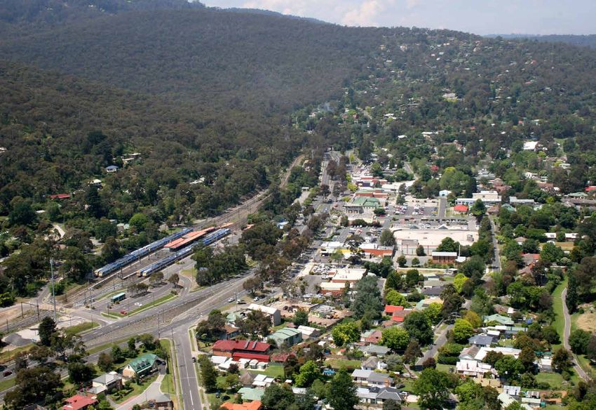
Part 1
                                                                                                                                                                            Part 2
Maps                                                            Figures                                                          Tables
Map 01. Aerial Plan                                       6    Figure 01. Components of the Upper Gully Plan               7   Table 1 – The Strategic Objectives   29
Map 02. Activity Centre                                  12    Figure 02. Strategic Plan Structure                         8   Table 2 – Built Form Guidelines      66
Map 03. Upper Gully (Study Area)                         13    Figure 03. Strategic Plan Stages                            9
Map 04. Context Map                                      15    Figure 04. Implementing the Vision                         27
Map 05. Movement and Access Improvement Opportunities    32    Figure 05. Dawson Street / Ferny Creek Trail -
                                                                           Existing Conditions                             33
Map 06. Maxi Foods / Burwood Highway
                                                                Figure 06. Dawson Street / Ferny Creek Trail -
        Entrance Improvements                            35
                                                                           Proposed Improvements                           33
Map 07. Rollings / Old Belgrave Roads                           Figure 07. Intersection of Hilltop Rd and Burwood Highway
        Improvement Opportunities                        36               looking east – Existing Conditions              34
Map 08. Public Open Space and Street                            Figure 08. Intersection of Hilltop Rd and Burwood Highway
        Improvement Opportunities                        38               looking east – Proposed Improvements            34
Map 09. Public Space and Street Improvement Opportunities 40   Figure 09. Dawson Street Enhancement Opportunity -
Map 10. Preferred Setbacks and Design Outcomes                             Existing Conditions                             39
        for Built Form                                   45    Figure 10. Dawson Street Enhancement Opportunity -
                                                                           Proposed Improvements                           39
Map 11. View Point 1 Key Plan                            47
                                                                Figure 11. Rose Street Shared Space Opportunity -
Map 12. View Point 2 Key Plan                            48               Existing Conditions                             41
Map 13. View Point 3 Key Plan                            49    Figure 12. Rose Street Shared Space Opportunity -
Map 14. View Point 4 Key Plan                            50               Proposed Improvements                           41
Map 15. View Point 5 Key Plan                            51    Figure 13. Indicative Built Form Sections                  46

Map 16. View Point 6 Key Plan                            52    Figure 14. Floor to ceiling height analysis                46
                                                                Figure 15. Proposed Built Form Illustration -
Map 17. Preferred Land Use Outcomes                      54
                                                                           Burwood Highway / Dawson Street View South-West 47
Map 18. Railway Station & Visitors Information Centre           Figure 16. Proposed Built Form Illustration -
        Improvement Opportunities                        58               Burwood Highway / Dawson Street View South-East 48
Map 19. 100-Year ARI Flood Depths (Melbourne Water) -           Figure 17. Proposed Built Form Illustration -
         Activity Centre                                 61               Burwood Highway / Rose Street View South        49
                                                                Figure 18. Proposed Built Form Illustration -
                                                                           Dawson Street / Mount View Road View North-West 50
                                                                Figure 19. Proposed Built Form Illustration -
                                                                           Burwood Highway looking south west              51
                                                                Figure 20. Proposed Built Form Illustration -
                                                                           Burwood Highway looking south east              52
                                                                                                                                                                            3
Upper Gully Strategic Plan

                             CONTENTS
                             1. Contents
                             1.    INTRODUCTION                               6
                             1.1   Introduction                               6
                             1.2   The Upper Gully Plan                       7
                             1.3   The Strategic Plan                         7
                             1.4   How to read this Strategic Plan            8
                             1.5   Developing the Strategic Plan              9
                             1.6   The Activity Centre                       12
                             1.7   Upper Gully (the Study Area)              12
                             2. SETTING THE SCENE 		                         14
                             2.1 Introducing Upper Gully                     14
                             2.2 Knox Policy Framework                       18
                             2.3 Engagement                                  22
                             2.4 Opportunities and Challenges                24
                             3. Vision and strategic objectives              26
                             3.1 The Vision for the Activity Centre          26
                             3.2 Implementing the Vision                     27
                             3.3 Strategic Objectives                        28
                             4.    THE STRATEGIC RESPONSE			                 30
                             5. BUILT FORM GUIDELINES                        64
                             5.1 Overview                                    64
                             5.2 Built Form Guidelines                       66
                             6.    IMPLEMENTATION 			                        74
                             6.1   Overview                                  74
                             6.2   Next Steps                                75
                             6.3   Management, Monitoring & Review           75
   4
                             6.4   Planning Scheme Implementation Approach   75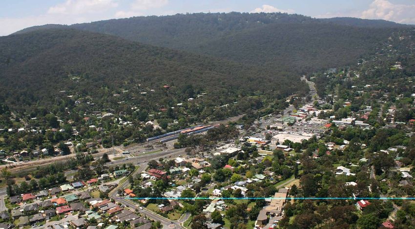
Part 1
                                                                                                                                                                            Part 2
Maps                                                            Figures                                                          Tables
Map 01. Aerial Plan                                       6    Figure 01. Components of the Upper Gully Plan               7   Table 1 – The Strategic Objectives   29
Map 02. Activity Centre                                  12    Figure 02. Strategic Plan Structure                         8   Table 2 – Built Form Guidelines      66
Map 03. Upper Gully (Study Area)                         13    Figure 03. Strategic Plan Stages                            9
Map 04. Context Map                                      15    Figure 04. Implementing the Vision                         27
Map 05. Movement and Access Improvement Opportunities    32    Figure 05. Dawson Street / Ferny Creek Trail -
                                                                           Existing Conditions                             33
Map 06. Maxi Foods / Burwood Highway
                                                                Figure 06. Dawson Street / Ferny Creek Trail -
        Entrance Improvements                            35
                                                                           Proposed Improvements                           33
Map 07. Rollings / Old Belgrave Roads                           Figure 07. Intersection of Hilltop Rd and Burwood Highway
        Improvement Opportunities                        36               looking east – Existing Conditions              34
Map 08. Public Open Space and Street                            Figure 08. Intersection of Hilltop Rd and Burwood Highway
        Improvement Opportunities                        38               looking east – Proposed Improvements            34
Map 09. Public Space and Street Improvement Opportunities 40   Figure 09. Dawson Street Enhancement Opportunity -
Map 10. Preferred Setbacks and Design Outcomes                             Existing Conditions                             39
        for Built Form                                   45    Figure 10. Dawson Street Enhancement Opportunity -
                                                                           Proposed Improvements                           39
Map 11. View Point 1 Key Plan                            47
                                                                Figure 11. Rose Street Shared Space Opportunity -
Map 12. View Point 2 Key Plan                            48               Existing Conditions                             41
Map 13. View Point 3 Key Plan                            49    Figure 12. Rose Street Shared Space Opportunity -
Map 14. View Point 4 Key Plan                            50               Proposed Improvements                           41
Map 15. View Point 5 Key Plan                            51    Figure 13. Indicative Built Form Sections                  46

Map 16. View Point 6 Key Plan                            52    Figure 14. Floor to ceiling height analysis                46
                                                                Figure 15. Proposed Built Form Illustration -
Map 17. Preferred Land Use Outcomes                      54
                                                                           Burwood Highway / Dawson Street View South-West 47
Map 18. Railway Station & Visitors Information Centre           Figure 16. Proposed Built Form Illustration -
        Improvement Opportunities                        58               Burwood Highway / Dawson Street View South-East 48
Map 19. 100-Year ARI Flood Depths (Melbourne Water) -           Figure 17. Proposed Built Form Illustration -
         Activity Centre                                 61               Burwood Highway / Rose Street View South        49
                                                                Figure 18. Proposed Built Form Illustration -
                                                                           Dawson Street / Mount View Road View North-West 50
                                                                Figure 19. Proposed Built Form Illustration -
                                                                           Burwood Highway looking south west              51
                                                                Figure 20. Proposed Built Form Illustration -
                                                                           Burwood Highway looking south east              52
                                                                                                                                                                            5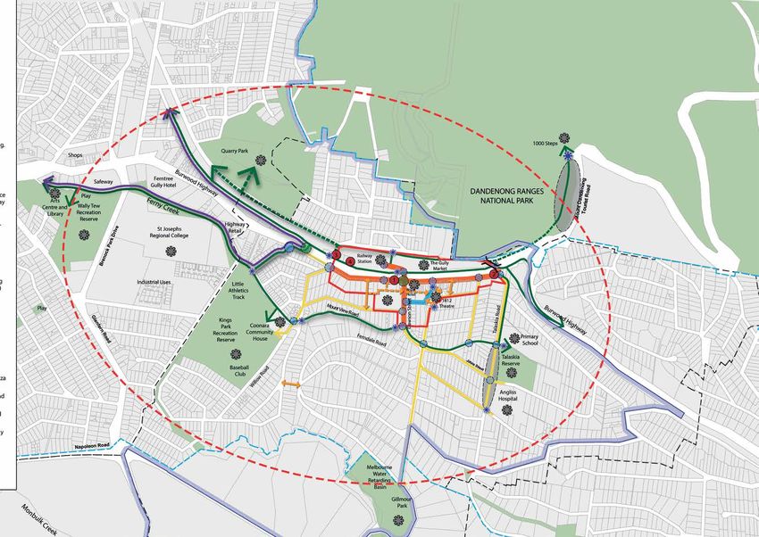
1. INTRODUCTION
Upper Gully Strategic Plan
1.1 Introduction Another focus of the Strategic Plan is protecting the Existing planning controls in Upper Gully limit
landscape setting of the Activity Centre, which is highly development and reinforce a relatively low density
The Upper Gully Strategic Plan (Strategic Plan) sets the valued by the community. The surrounding Dandenong residential development in order to protect the existing
framework for the future development and improvements Ranges are visible throughout the Activity Centre forming foothills character and vegetation cover. As a result,
to Upper Gully (refer Map 01), including recommendations a strong visual backdrop. The built form guidelines, opportunities for change and housing diversity within
for built form controls for the Upper Ferntree Gully including building height recommendations complement Upper Gully are generally limited to the Activity Centre.
Neighbourhood Activity Centre (Activity Centre). It also the strong connection to the surrounding foothills. The Strategic Plan supports housing opportunities across
outlines Knox City Council’s commitment to support the the Activity Centre to provide additional housing choices
opportunities and stimulate future investment, partnership close to shops and services.
and advocacy on private and State owned land in Upper
Gully (Study Area). AERIAL PLAN
The Strategic Plan is guided by a vision that aims to support
the development of a vibrant and well serviced Activity
Centre, capturing the opportunities for business and
growth, while responding to Upper Gully’s unique foothills
setting and its relationship with the Dandenong Ranges.
Upper Gully’s location at the Gateway to the Dandenong
Ranges presents significant tourism opportunities, which
are identified through the Strategic Plan. The Strategic
Plan supports hospitality and entertainment uses to
complement and build on existing facilities and visitor
attractions such as the Dandenong Ranges National Park,
the 1,000 Steps, the 1812 Theatre, The Gully Market and the
Visitors Information Centre. The Strategic Plan also builds
on Upper Gully’s existing strengths including the visitor
attractions, health services industry, the local retail offer and
the proximity of the Upper Gully Railway Station.
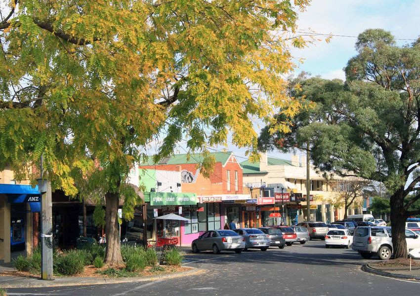
The Activity Centre includes the retail and commercial
centre of some 15.7ha in Upper Gully. The Activity Centre is
defined by the Design and Development Overlay - Schedule
10 (DDO10) boundary included in the Knox Planning
Scheme and is referred to as the Activity Centre throughout
the Strategic Plan.
A key influence on the Activity Centre is the surrounding
catchment, which comprises predominately residential uses
and commercial uses along Burwood Highway and open
space areas. This surrounding catchment, as illustrated on
Map 01, is generally referred to as Upper Gully. NOT TO SCALE
6
Map 01. Aerial Plan
Part 1
Importantly, the Strategic Plan capitalises on the              1.3 The Strategic Plan                                          Gully and Alchester Village for a period of 18 months.
opportunities offered to Knox City Council in advocating                                                                        Amendment C146 extended the interim heigh controls

                                                                                                                                                                                                Part 2
to and developing partnerships with major State                 The Strategic Plan outlines the preferred vision for the        until 30 October 2017. The interim DDO10 provided
Government agency landholders in Upper Gully including          future growth and development of Upper Gully based              Council with the time needed to complete detailed
VicTrack, VicRoads and Department of Environment, Land,         on community and stakeholder aspirations and priorities.        planning work for the Activity Centre needed to inform
Water and Planning (DELWP) to improve public assets,            It is a strategic planning tool to manage, influence and        development including permanent building design and
services and places. These opportunities are offered            facilitate future change in Upper Gully and assist Council      height controls.
along Burwood Highway, the rail corridor, and the land          in decision making. It considers the current conditions,
                                                                issues and opportunities and develops ideas to influence        The Strategic Plan complies with the aims of DELWP’s
surrounding the Upper Ferntree Gully Railway Station.
                                                                future change and deliver real outcomes against                 Practice Note 58: Structure Planning for Activity Centres.
The proposed streetscape and public space improvements
throughout Upper Gully aim to create a strong brand             aspirations and priorities.
for the Activity Centre that builds on its foothills setting,                                                                   1.3.1 Who will use the Strategic Plan
                                                                More specifically, the Strategic Plan aims to:
artistic and cultural influences, and capitalise on the                                                                         The Strategic Plan will be used by a range of stakeholders,
opportunities to improve public space amenity and               ■■   Provide a framework for guiding Council business and       including:
services for local residents and visitors alike.                     developing partnerships with major landholders and
                                                                     service providers including state government agencies      Knox City Council
                                                                     to activate and provide the certainty needed for future
1.2 The Upper Gully Plan                                             and ongoing improvements for Upper Gully;
                                                                                                                                ■■   For informing changes to the Knox Planning Scheme,
                                                                                                                                     which will guide Council’s assessment of planning
The planning for future development and improvements            ■■   Direct investment to capture the unique opportunities           permit applications in the Activity Centre;
for Upper Gully are articulated through the Upper Gully              including those for business and tourism, presented by
Plan, which includes two key elements:                                                                                          ■■   For identifying and prioritising future capital works
                                                                     Upper Gully’s location, setting and individuality;
                                                                                                                                     projects for Upper Gully;
■■   The Upper Gully Strategic Plan (Strategic Plan)            ■■   Provide certainty for Upper Gully by guiding future
     sets a framework for managing future development                                                                           ■■   For identifying future programs and services required
                                                                     improvements and development, including planning
     in the Activity Centre and Knox City Council’s strategic                                                                        within Upper Gully; and
                                                                     controls;
     investment in Upper Gully based on technical                                                                               ■■   For advocating and seeking funding for studies and
                                                                ■■   Deliver the objectives and strategies, outlined as part
     research, community and stakeholder priorities; and                                                                             projects as outlined by the Strategic Plan.
                                                                     of the Knox Vision and Knox City Plan 2013-17 at a local
■■   The Streetscape Design Project focuses on physical              level; and                                                 Landowners / Residents / Business Operators / Traders
     streetscape improvements to the public realm within
                                                                ■■   Be informed by significant research and stakeholder        ■■   For guiding future improvements and/ or
     the Activity Centre.
                                                                     engagement.                                                     developments on private land; and
                                                                To assist in implementing the Strategic Plan, steps are         ■■   For identifying opportunities to actively participate in
                      UPPER GULLY PLAN                          identified that Council and the community can take to                the future development and improvement of Upper
                                                                achieve the plan’s vision (refer section 3).                         Gully.
                                                                The Strategic Plan has also been developed in response          State Government Agencies (e.g. DELWP, Parks Victoria,
                                                                to concerns raised regarding the lack of specific planning      VicRoads, VicTrack)
                                                                controls for the Activity Centre within the Dandenong
                                                                Foothills. Amendment C130 incorporated into the Knox            ■■   For guiding the management and improvements to
       UPPER GULLY                       STREETSCAPE                                                                                 state government owned assets.
                                                                Planning Scheme on 20 November 2014, introduced an
      STRATEGIC PLAN                    DESIGN PROJECT
                                                                interim Design and Development Overlay Schedule 10
     (STRATEGIC PLAN)
                                                                (DDO10), applying a mandatory maximum building height                                                                           7
                                                                of 7.5m in the activity centres of The Basin, Upper Ferntree
Figure 01. Components of the Upper Gully Plan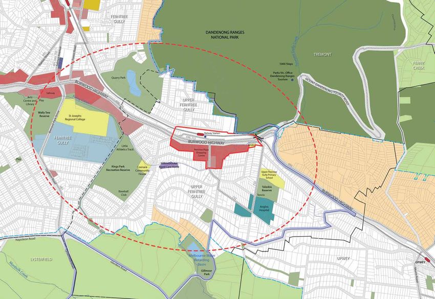
Upper Gully Strategic Plan

                             1.4 How to read this Strategic Plan
                                                                                                                                        THE STRATEGIC PLAN
                             The Strategic Plan consists of two parts:
                             ■■   Part 1 - Strategic Plan – Provides a shared vision                     PART 1: STRATEGIC PLAN                            PART 2: IMPLEMENTATION PLAN
                                  for Upper Gully (informed by Council and the local
                                  community) and outlines a strategic approach to
                                                                                                                                                                   1. INTRODUCTION
                                  managing future development and investment to                             1. INTRODUCTION
                                  achieve this vision.                                                                                               Provides the framework for the implementation
                                                                                              Introduction to the Strategic Plan and its purpose
                                                                                                                                                        of actions contained in the Strategic Plan.
                             ■■   Part 2 - Implementation Plan – Provides the
                                  framework for implementing actions and measuring
                                  the success of strategies, including recommended
                                  changes to the Knox Planning Scheme.                                    2. SETTING THE SCENE
                                                                                            Provides an overview of the project process, strategic      2. PRIORITY PROJECTS AND STAGING
                             Figure 02 outlines the structure of the two parts of the
                             Strategic Plan.                                                          influences and drivers of change

                                                                                                 3. VISION AND STRATEGIC OBJECTIVES
                                                                                                                                                        3. MANAGEMENT, MONITORING AND
                                                                                              Sets out a vision and strategic objectives to guide                  REVIEW
                                                                                                    future development and investment

                                                                                                       4.THE STRATEGIC RESPONSE
                                                                                              Provides a framework for managing Upper Gully’s              4. IMPLEMENTATION PROGRAM
                                                                                               future development and investment to achieve
                                                                                                                the vision

                                                                                                       5. BUILT FORM GUIDELINES
                                                                                            Sets the planning policy framework required for the
                                                                                            Planning Scheme Amendment for the Activity Centre

                                                                                                            6. IMPLEMENTATION
                                                                                            Provides the framework for the Implementation Plan.

   8                                                                                    Figure 02. Strategic Plan Structure
Part 1
1.5 Developing the Strategic Plan                                                            1.5.1 Understanding the Site & Future Aspirations               1.5.2 Developing the Vision & Strategic Objectives

                                                                                                                                                                                                                           Part 2
The Strategic Plan has been developed through significant                                    Stage 1 - Consolidated Background Report and                    Stage 2 - Agenda Setting and Visioning
analysis, community and stakeholder engagement and the                                       Technical Reports                                               This stage involved developing a draft vision, strategic
testing and development of ideas and scenarios. This has
                                                                                             This stage focused on understanding the current state and       objectives and strategies, building on the Consolidated
occurred across a number of project phases, as outlined in
                                                                                             future aspirations for Upper Gully through background           Background Report and feedback provided from Stage
Figure 03.
                                                                                             research, technical reports and community and                   1 of community and stakeholder engagement. This
                                                                                             stakeholder engagement.                                         provided a platform for further discussions with the
                           STAGE 1                                                                                                                           community and guidance for the planning and design of
                    BACKGROUND RESEARCH                                                      The Consolidated Background Report supports the
                                                                                                                                                             the Activity Centre.

                                                         COMMUNITY & KEY STAKEHOLDER INPUT
                     & TECHNICAL REPORTS                                                     Strategic Plan, outlines important background information
                                                                                             and identifies a number of opportunities for how Upper          Preliminary strategies were developed to provide a
                                                                                             Gully could be planned into the future. The report              number of initial thoughts and ideas for how Upper Gully
                                                                                             provides a summary of research and investigations               could be planned and improved into the future.
                                                                                             undertaken by the consultant team (including Technical
  Knox Vision

                            STAGE 2                                                          Reports), and the findings of community and stakeholder         1.5.3 Development and Delivery
                      SET THE VISION TEST
                                                                                             engagement.
                      IDEAS & DIRECTIONS
                    (STRATEGIC OBJECTIVES)
                                                                                                                                                             Stage 3 & Stage 4 - Draft Strategic Plan &
                                                                                             The Technical Reports prepared to support the Strategic         Implementation Plan
                                                                                             Plan and the Consolidated Background Report include:
                                                                                                                                                             Developing the draft Strategic Plan involved testing and
                                                                                             ■■   ‘Technical Report - Transport and Parking’, January 2015   refining the vision and strategic objectives/key directions
                                                                                                  and ‘Addendum 2017’. This report outlines parking          to inform its content. The background research, technical
                           STAGE 3
                     THE STRATEGIC PLAN
                                                                                                  occupancy and traffic survey results and provides a        reports and engagement outcomes were also utilised
                       (INVESTMENT &                                                              review of sustainable transport options.                   to inform the vision, strategic objectives, strategies
                       DEVELOPMENT)                                                          ■■   ‘Technical Report - Land Use and Economics’, November      and actions to guide Knox City Council’s commitment
                                                                                                  2014 ‘Addendum 2017’. This report provides a technical     for future investment, partnership and advocacy for
                                                                                                  assessment of the relevant economic and property           Upper Gully. This stage informed the development of
            STAGE 4A
                                         STAGE 4B                                                 considerations, which influence land use and               the Implementation Plan, Built Form Guidelines and
                                     PLANNING SCHEME                                              development in the Activity Centre.                        subsequent Planning Scheme Amendments.
       IMPLEMENTATION PLAN
                                        AMENDMENT
                                     (ACTIVITY CENTRE)                                       ■■   ‘Heritage Assessment Report, Upper Ferntree Gully’, June
                                                                                                  2015. This report outlines the significant social and
Figure 03. Strategic Plan Stages                                                                  cultural built form features for consideration in the
                                                                                                  Strategic Plan.

                                                                                                                                                                                                                           9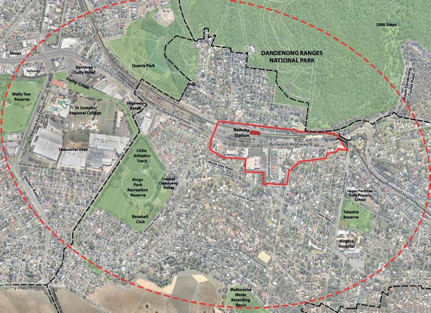
Upper Gully Strategic Plan

10
Part 1
1.5.4 Public Exhibition & Planning Panel Process

                                                            Part 2
Amendment C141 to the Knox Planning Scheme, draft
Strategic Plan (December 2015), draft Implementation
Plan (December 2015) and supporting background and
technical reports were publicly exhibited from 8 February
to 29 March 2016. Council received 344 submissions
during public exhibition.
On 28 June 2016 and after considering submissions,
Council revised the Building Heights and Setbacks Map
and requested the Minister for Planning appoint an
independent Planning Panel to consider submissions to
Amendment C141. Council also provided the opportunity
to make a submission or revise original submissions until
12 September 2016. A further 116 submissions were
received, which were referred to the Planning Panel. A
combined total of 460 submissions were received during
public exhibition.
An independent Panel Hearing was held on 15, 17 and 18
November 2016.

                                                            11
Upper Gully Strategic Plan
1.6 The Activity Centre
The Activity Centre includes the retail and commercial
centre of Upper Ferntree Gully. The Activity Centre
boundary is defined by the existing Design and
Development Overlay - Schedule 10 (DDO10) boundary
included in the Knox Planning Scheme.
While the Strategic Plan focuses on the Activity Centre,
influences outside the Activity Centre, including the needs
for catchment area it services, were also considered in
order to provide a holistic and integrated plan for the
future. These influences are detailed in Section 2.
1.7 Upper Gully (the Study Area)
A key influence on the Activity Centre is the surrounding
catchment, which comprises predominately residential,
commercial and public uses along Burwood Highway and
open space areas. This surrounding catchment is referred
to as Upper Gully in the Strategic Plan (refer Map 03). The ACTIVITY CENTRE DANDENONG
technical investigations used to develop the Strategic Plan RANGES NATIONAL
PARK
RAILWAY AV
considered influences, such as the services available and E
needs of residents in Upper Gully. RAILWAY
STATION
CFA
NB. Upper Ferntree Gully is used to reference the suburb and D
LO WR
generally where available source data is suburb based for example WIL
BURWOOD HIGHWAY
ABS suburb profile data.
KINDER
ROYAL HOTEL
FERNTREE
PLAZA
SHOPPING
CENTRE ROSE ST
GS RD
DAWSON ST
ROLLIN
ALFRED ST
M ST
WILLIA
12
Map 02. Activity CentreUPPER GULLY (STUDY AREA)
Part 1
Part 2
ACTIVITY CENTRE
UPPER GULLY (STUDY AREA)
NTS
13
Map 03. Upper Gully (Study Area)2. SETTING THE SCENE
Upper Gully Strategic Plan
2.1 Introducing Upper Gully
2.1.1 The Setting 2.1.3 Public Transport
Upper Gully is located at the foothills of the Dandenong The Upper Ferntree Gully Railway Station (Railway Station)
Ranges. It has a distinct visual character that is defined is located on the Belgrave line. The journey between
by its relationship with the surrounding treed landscape. Melbourne and Upper Ferntree Gully generally takes
Views to the surrounding hills, low density green and leafy between 45 - 65 minutes. The frequency of services,
residential neighbourhoods are important and highly parking and accessibility makes the Railway Station an
valued by the local community. important commuter station for locals. As a ‘premium
Upper Gully is physically divided by Burwood Highway, station’, the Railway Station is staffed from the first
a major transport corridor that provides access between train to the last, has a customer service centre (where
Melbourne and the eastern suburbs. It also provides a passengers can buy tickets, and pick up timetables), and
gateway for visitors to the Dandenong Ranges and the has passenger facilities such as indoor waiting areas
nearby Kokoda Memorial Trail (also known as the 1,000 and toilets. As a result, the Railway Station is utilised by
Steps) and Upper Gully’s function as a gateway is further commuters from surrounding areas.
reinforced by the presence of the Dandenong Ranges A bus interchange is also located at the Railway Station
Visitors Information Centre, located on Burwood Highway catering for three bus routes. These routes operate both
(refer Map 04 overleaf ). along Burwood Highway, as well as local roads including Mix of retail, commercial and highway related uses are
Dawson Street, Albert Street, Talaskia Road and Rollings provided along Burwood Highway
2.1.2 Walking and Cycling Road, to service facilities such as Angliss Hospital and
The Activity Centre, generally, has good walking facilities Upper Ferntree Gully Primary School.
in place with wide footpaths along shop frontages.
Pedestrian connections into surrounding residential areas 2.1.4 Vehicle Access and Parking
are provided however, steep topography in some areas Analysis for the Activity Centre identified a number
makes walking difficult. Burwood Highway and railway of locations where traffic could be better managed to
line creates a pedestrian and cycling barrier particularly improve motorist and pedestrian safety and improve
for residents north of the Activity Centre. traffic flow. Such locations included the intersection of
Bike routes are provided through off-road trails along Burwood Highway and Rollings Road and the vehicle
the railway line, Ferny Creek and parts of the Burwood entrance into Ferntree Plaza from Burwood Highway.
Highway. The Ringwood to Belgrave Rail Trail is an The shopping areas of Upper Gully are generally well
important regional cycle connection however, there is a catered for with car parking. However, parking occupancy
missing link across the Burwood Highway. A continuous issues exist at the Railway Station car park and in
connection between the Activity Centre and station is not residential streets close to the activity centre and near the
provided. Angliss Hospital where commuters and employees take
There are opportunities to enhance walking and cycling advantage of the unrestricted parking.
facilities, not only in the Activity Centre, but also along Management of visitor parking around the 1,000 Steps
key streets and trails that lead to the shops and railway has also been identified as an issue with overflow parking
14
station. along Mount Dandenong Tourist Road creating safety
issues for motorists, pedestrians and cyclists. Ferny Creek Trail provides an open space link to major
open spaces within and surrounding Upper GullyCONTEXT MAP
Part 1
Part 2
Port
CITY OF
Phillip KNOX
Bay
ACTIVITY CENTRE
UPPER GULLY (STUDY AREA)
NOT TO SCALE
15
Map 04. Context MapUpper Gully Strategic Plan
2.1.5 Land uses Coonara House located in Kings Park is a neighbourhood The 1812 Theatre Company is recognised as one of
house and provides a range of learning and community Melbourne’s longest running amateur theatre companies
The Activity Centre is relatively compact, and focused services to the local community. Other community and provides an important role in developing arts and
along Burwood Highway and Dawson Street. It includes facilities are generally located around Talaskia Road and culture within the municipality. There are opportunities
a mix of retail, commercial and highway related uses and Kings Park. to strengthen the role of the Theatre to increase local
is anchored by Ferntree Plaza and Maxi Foods, a full line participation and social interaction, and to enhance it as
supermarket. The Activity Centre provides a number of Housing is currently provided outside of the Activity
an attraction for visitors.
functions including local convenience retail, community Centre in the form of detached dwellings on large
and health services, and a tourism function for visitors lots. Existing planning controls applied to surrounding There is also strong history of art and artists in Upper
travelling to the nearby Dandenong Ranges. residential areas limit opportunities for additional housing Gully associated with the Dandenong Ranges. However,
outside of the Activity Centre. public art and references to Upper Gully’s artistic history
The Angliss Hospital located on Talaskia Road (outside is limited in the Activity Centre. Opportunities exist to
the Activity Centre) provides a key focus for health The Activity Centre provides opportunities for different
incorporate exciting and relevant public art into future
services within Upper Gully and to a large area of the types of housing such as apartments or shoptop housing
projects across the Activity Centre.
eastern metropolitan region. It is supported by a range which would enable people to age in place and benefit
of allied health and community services located around from proximity to shops, public transport and services. At Wally Tew Reserve is a key location for arts and culture
the hospital and within the Activity Centre. These provide present, housing is not provided in the Activity Centre. located approximately 1.6km from the Activity Centre.
employment opportunities for Upper Gully, with much It includes a number of cultural facilities including the
of the current local workforce employed in the health 2.1.6 Tourism Library, Placemakers Shed and Woodworkers Shed. The
industry. Placemakers Shed and Woodworkers Shed provide a
Upper Gully is located at the Gateway to the Dandenong studio and workshop for creative people within Upper
Ranges and is the last centre people pass through before Gully. As well as the library, a number of arts and culture
heading into the Ranges. The Activity Centre is bordered events are held at the reserve, including Knox Festival.
by the Dandenong Ranges National Park to the north
and is the location for the Dandenong Ranges Visitors The Gully’s Mens Shed is located in the Rangers House
Information Centre. It is only 800m from the major at the base of the 1,000 Steps in the Dandenong Ranges
tourist attraction of the 1,000 Steps, which is growing National Park.
significantly in its popularity.
There are significant opportunities to strengthen Upper
Gully’s tourism role as part of the arrival experience into
the Dandenong Ranges. This could be through additional
tourism land uses that build on existing tourist attractions
such as The Gully Market which operates on Saturday
and Sunday, the 1812 Theatre, and existing restaurants
and cafés. Opportunities also exist to enhance Upper
Gully’s streets and public spaces to enhance its brand and
attractiveness as a centre.
2.1.7 Arts and Culture
Upper Gully has an active arts and culture community
16 with the 1812 Theatre providing a local focal point.
The Angliss Public Hospital and supporting health uses The 1812 Theatre, located on Rose StreetPart 1
2.1.8 Open Space and Landscape 2.1.9 Built Form two principal façades, is another excellent example of Art
Deco architecture.
Part 2
The major parks in Upper Gully include Kings Park, Buildings within the Activity Centre are predominately
Talaskia Reserve and Quarry Park. These spaces provide low scale single storey with the occasional two storey The Upper Ferntree Gully Railway Station building is
the location for a number of sporting and social groups building providing subtle variation in the skyline and of architectural, historic and social significance. It first
and provide visual relief and ‘greening’. Social and cultural views across to the surrounding treed foothills. Most opened in 1889. The heritage and older style buildings
facilities are provided at Wally Tew Reserve, located notable is the Royal Hotel, at a height of approximately provide visual landmarks in the Activity Centre and a
in nearby Ferntree Gully. Ferny Creek Trail provides a 12.5m, which makes it the tallest building within the link to the area’s early development. These buildings
key open space link between Wally Tew Reserve and Activity Centre. Although the Royal Hotel is only two along with the 1812 Theatre and were identified by the
the Activity Centre, as well as between Kings Park and storeys, it is equivalent in height to a modern three storey community as important and valued historical buildings.
community facilities. There is a lack of significant civic building. The Royal Hotel is complemented by the Visitors There are opportunities to enhance these valued buildings
open spaces available in the Activity Centre. Information Centre, another two storey Art Deco style and reinforces nearby development to be designed to
building located diagonally opposite the hotel, on the complement their historical significance.
The natural landscape is a significant contributor to Upper
northern side of Burwood Highway. Adjoining the Activity Centre at 12 Mount View Road is the
Gully’s character and identity. Trees both within the public
(streets and parks) and private realm (surrounding canopy The style and character of buildings across the Activity post war modernist style St Thomas Anglican Church. It
trees on lots) provide a strong link between the urban Centre is generally undefined with simple detailing and was designed by the notable architect Keith Reid and is
areas of Upper Gully and the Dandenong Ranges. parapets. Styles include a mix of recent (approx. 1980’s), also a locally significant historical building.
recently modified buildings and the occasional older An independent heritage assessment for the Activity
built form styles, reflecting the incremental growth of the Centre was undertaken as part of this project. The
Activity Centre over a period of time. The surrounding recommendations of the assessment have been
catchment of the Activity Centre is predominantly incorporated as part of the Planning Scheme Amendment.
residential and generally detached dwellings on large lots.
For further information on the heritage assessment refer
Narrow shop fronts (fine grain built form) along Burwood to the Consolidated Background Report and the Upper
Highway, to the east of Dawson Street, are major Ferntree Gully Activity Centre Heritage Assessments Report
contributors to the positive street experience. These (Context 2015).
buildings provide visual interest through the detailing
and design of building elements, but also through
elements such as a continuous built edge to the street,
active ground floor uses, transparent frontages, awnings
and clearly defined pedestrian entries. To the west of
Dawson Street, as the scale and form of buildings increase,
buildings are setback from the street with less active uses.
2.1.10 Heritage
The Royal Hotel is the key historical building located in the
Activity Centre that is currently protected by the Heritage
Overlay. It was built in 1889 and then remodelled with an
Art Deco façade in 1935.
Quarry Park provides the location for State Significant The Visitors Information Centre is located on an elevated
vegetation The Royal Hotel is a land mark building in Upper Ferntree 17
position with bold rectangular and curved styling on the GullyUpper Gully Strategic Plan
2.2 Knox Policy Framework Knox Housing Strategy 2015
The Knox Housing Strategy 2015 (the Housing Strategy)
This section provides a summary of key planning policies,
aims to balance the changing housing needs of current
documents and strategies that have influenced the
and future residents while ensuring that important
development of the Strategic Plan.
aspects of Knox are retained and enhanced. The major
trends which the Housing Strategy responds to include:
2.2.1 Key Plans and Strategies ■■ An aging population;
Knox Vision and City Plan ■■ Growing lone person households;
The Knox Vision provides a shared vision for the future ■■ Growing couple only households; and
of Knox that will deliver the lifestyle, jobs and industry, ■■ Small drop in households with children.
health and wellbeing desired by members of the Knox
community. The Vision is outlined under five themes, The environmental quality and significance of the
each containing a description of the ideal future, and
identifying the features that will be in place when that
2013-17Knox Vision 2013-17 1
Dandenong Ranges is also reflected in the Housing
Strategy.
future is achieved: Knox Vision document The Housing Strategy utilises a scaled approach to
■■ Democratic and Engaged Communities housing development, setting out the preferred types
of housing in four different areas. The surrounding
■■ Healthy, Connected Communities residential areas of Upper Gully are considered part of the
■■ Prosperous, Advancing Economy Bush Suburban category i.e. areas which have significant
biological and landscape values.
■■ Vibrant and Sustainable Built and Natural
Environments The Housing Strategy indicates that the surrounding
■■ Culturally Rich and Active Communities residential area will continue to be low-scale
neighbourhoods, characterised mostly by detached
These themes are used as indicators to monitor the houses, where significant indigenous and native
community’s wellbeing and achievement toward the vegetation is retained and complemented. It also
broader Vision for Knox. indicates that the preferred housing types in this area is
The Knox City Plan outlines the barriers, enablers and detached dwellings and dual occupancies.
key strategies for achieving the aspirations for each The Strategic Plan, does not consider changes to land use
theme outlined as part of the Knox Vision. These themes zoning and built form controls in surrounding residential
have provided a framework for the development of the areas, as these have been already been considered as part
Strategic Plan and the vision and strategic objectives of the Knox Housing Strategy, 2015 and the associated
contained in this report (refer Sections 3 and 4). The Planning Scheme Amendment C131.
Strategic Plan aims to deliver the objectives and strategies
contained in Knox Vision and City Plan, at a local level.
18Part 1
2.2.2 State Government Policy 2.2.3 State Planning Policy 2.2.4 Local Planning Policy
Part 2
Plan Melbourne Clause 11 Settlement - Provides strategic direction for Clause 21.01 Municipal Profile – Provides the context and
Plan Melbourne was released in May 2014, by the future land uses. Upper Ferntree Gully is identified in the high level planning framework for Knox. The clause notes
then State Government. The document is Melbourne’s hierarchy of Activity Centres as a Neighbourhood Activity that “Urban consolidation objectives must not outweigh the
metropolitan planning strategy for the next 40 years and Centre. environmental and landscape objectives for the foothills”.
will guide its development and growth, including matters Clause 12 Environment and Landscape Values - Seeks Clause 21.04 Urban Design - Provides the strategic
such as infrastructure, housing, employment, transport to protect sites and features of nature conservation, direction for the provision of built form that is ecologically
and the environment. biodiversity, geological or landscape value. sustainable and site responsive and for public art,
Directions relevant to Upper Gully in Plan Melbourne signage and landscaping along Burwood Highway and
Clause 13 Environmental Risk - Supports future planning for improved pedestrian networks within Upper Gully. A
include:
and design to appropriately respond to hazards and key objective of this clause is to: “Protect and enhance the
■■ Direction 2.2 – Reduce the cost of living by increasing minimise risks from landslip, bushfire and flooding. aesthetic, environmental and landscape values and vistas of
housing supply near services and public transport. the Dandenong Foothills, Dandenong Creek Valley, local and
Clause 15 Built Environment and Heritage - Supports
■■ Direction 4.1 – Create a city of 20 minute the future planning and design to provide high quality national parklands”. The clause also notes that built form is a
neighbourhoods. urban design that responds to the needs of the major contributor to long-term sustainability through the use
■■ Direction 4.2 – Protect Melbourne and its suburbs community and the intrinsic qualities of the place. of Ecologically Sustainable Development (ESD) principles.
from inappropriate development. Clause 21.05 Housing - Provides direction for the provision
Clause 16 Housing - Supports future planning and design
■■ Direction 4.3 – Create neighbourhoods that are safe to provide for potentially increased housing supply and of housing that appreciates its activity centre context and
for communities and healthy lifestyles. diversity within the Activity Centre. valued landscape setting.
■■ Direction 4.4 – Plan for future social infrastructure. Clause 21.07 Economic Development - Provides direction in
Clause 17 Economic Development - Provides the
■■ Direction 4.5 – Make our city greener. strategic direction to require future planning and design terms of its economic activity and its broader economic role
■■ Direction 4.8 – Achieve and promote design provides a range of land uses within the Activity Centre within the municipality, including its role as a gateway to the
excellence. that provide for both local and tourist needs. Dandenong Ranges.
■■ Direction 5.1 – Use the city structure to drive Clause 18 Transport - Supports future planning and Clause 21.08 Infrastructure - Provides direction for the
sustainable outcomes in managing growth. design to provide a range of integrated and sustainable provision of physical and social services, and the need for
■■ Direction 5.2 – Protect and restore natural habitats in transport systems to make it easy and safe or people to new development to be adequately serviced so as not to
urban and non-urban areas. get around. have a detrimental effect on the environment.
The Strategic Plan and the Knox Planning Scheme must be Clause 19 Infrastructure - Supports the location of Clause 22.01 Dandenong Foothills - Provides direction in
consistent with State Government strategies and policies community resources that are highly accessible by public terms of the design of buildings in order to retain key views
such as Plan Melbourne. transport and walking and cycling paths. It also supports and aims to protect and enhance the landscape significance
the provision of water supply, sewerage and drainage of the Dandenong Foothills.
services efficiently and effectively to meet State and Clause 22.12 Residential Land Use and Development in
community needs and protect the environment. a Commercial 1 Zone - Provides direction for the preferred
built form and character controls for a commercial centre in
the Dandenong Ranges Foothills.
19Upper Gully Strategic Plan
2.2.5 Zones and Overlays OVERLAYS Environmental Significance Overlay (ESO)
Overlays specify planning controls that apply to a ESO3 - Dandenong Ranges Buffer - recognises the
ZONES single issue or related set of issues (such as heritage, environmental significance of indigenous vegetation
Upper Gully is affected by the following zones. environmental concern or flooding). Consequently, a site to provide an ecological buffer zone to the Dandenong
may be affected by multiple overlays. Ranges. Only land north of Burwood Highway is affected
Commercial 1 Zone (C1Z)
by the overlay.
Promotes vibrant mixed use commercial centres for retail,
office, business, entertainment and community uses, as Bushfire Management Overlay (BMO)
well as residential uses at densities complementary to the Heritage Overlay (HO)
The BMO identifies areas where bushfire is considered a
role and scale of the commercial centre. hazard and warrants bushfire protection measures to be HO29 – Royal Hotel applies to the Royal Hotel located on
implemented. the corner of Dawson Street and Burwood Highway, Upper
Ferntree Gully. The Heritage Overlay aims to conserve and
Neighbourhood Residential Zone (NRZ)
enhance heritage places of natural or cultural significance
Supports development that respects the neighbourhood Design and Development Overlays (DDOs) and requires that development does not adversely affect
character of the area, implement neighbourhood Design and Development Overlays apply to both the these places.
character policy, provide a diversity of housing types Activity Centre and the surrounding residential areas
and moderate housing growth in locations offering of Upper Gully and generally limit the opportunity for
good access to services and transport. It also allows for Significant Landscape Overlay (SLO)
further growth.
educational, religious, recreational and community, and ■■ SLO2 - Dandenong Foothills: Foothills Backdrop and
a limited range of non-residential uses to serve the local ■■ DDO1 - Dandenong Foothills: Foothills Backdrop and Ridgeline Area – aims to facilitate development does
community in appropriate locations. Ridgeline Area - development within this area must not impede views towards the Dandenong Ranges.
respect the existing subdivision character of the
area and allow for tree retention and planting. A key ■■ SL03 - Dandenong Foothills: Lower Slope and Valley
Public Use Zone 4 – Transport (PUZ4) development control is the minimum subdivision size Area – aims to protect visually sensitive areas of the
of 1,000sqm and site coverage control. Dandenong Foothills due to its proximity to the slopes
Aims to recognise public land use for public utility
of the Dandenong Ranges, which is recognised by the
and community services and facilities, and provide for ■■ DDO2 - Dandenong Foothills: Lower Slope And Valley Natural Trust as having significant landscape values.
associated uses that are consistent with the intent of the Area – development within this area must respect the
public land reservation or purpose. existing subdivision character of the area and allow
for tree retention and planting. A key development Vegetation Protection Overlay (VPO)
control is the minimum subdivision size of 500sqm, VPO1 - Remnant Vegetation with a High Degree
Public Use Zone 6 –Local Government (PUZ6) ■■
site coverage controls and building height of 7.5m. of Naturalness - recognises the significance of the
Aims to recognise land for community facilities and
■■ DDO10 - Interim Neighbourhood Centre Height vegetation within close proximity to the Dandenong
services, and covers kindergarten on the corner of
Control – provided interim height controls of 7.5m for Ranges National Park, both visually and ecologically. .
Burwood Highway and Rollings Road.
the Activity Centre, allowing Council time to complete The Strategic Plan reviews the extents of the Significant
detailed planning work to inform permanent height Landscape Overlay (SLO2) and Vegetation Overlay (VPO1
controls. This overlay was removed over the Activity and VPO2) in the Activity Centre.
Centre as part of this project.
The Strategic Plan process determined the most
20 appropriate Design and Development Overlay for the
Activity Centre.Part 1
2.2.6 Other Considerations Flooding The guidelines set out the following requirements for
Flood mapping undertaken for Upper Gully (refer freeboard levels:
Part 2
Upper Gully is also affected by a number of other
elements and considerations: to section 7.9 Natural Hazards of the Consolidated
■■ For development within a floodplain (LSIO) - Building
Background Report), indicates that a significant portion
floor levels should be at least 0.6m above the 100-year
Areas of Cultural Heritage Sensitivity of the Activity Centre is affected by drainage issues. Key
ARI flood level. Outbuilding floor levels should be at
drainage issues include:
A significant proportion of the Activity Centre is located least 0.3m above the 100-year ARI flood level.
within an area of cultural heritage sensitivity (i.e. within ■■ 100-year Average Recurrence Interval (ARI) Flood ■■ For development within an overland flow path (SBO)
200m of Ferntree Creek). Refer to section 8.2 of the Event - This indicates that some private properties - Building floor levels should be at least 0.3m above
Consolidated Background Report. Under the Aboriginal within Activity Centre boundary will be subject to the 100-year ARI flood level. Outbuilding floor levels
Heritage Act 2006 a Cultural Heritage Management Plan is depths of up to 600mm during a 100-year ARI flood should be at least 0.15m above the 100-year ARI flood
required ‘if all or part of the proposed activity is in an area event as determined by Melbourne Water. level.
of culture heritage sensitivity, and all, or part of the activity ■■ Flood paths have been determined based on contour
is a high impact activity’. Building regulations set the height of buildings from
data only and therefore are indicative. Presently, flooding. Building regulations capture all applications,
Council requires a property affected by an identified even if a planning permit is not required.
Bushfire Risk
overland flow path to require discharge from property
Upper Ferntree Gully is considered by the CFA to have at pre-development levels, consistent with state
an ‘extreme risk’ for fire and does not have a designated policy.
Neighbourhood Safer Place (identified fire refuge area)
Planning Scheme controls include the Land Subject to
as it is considered safer to move out of the area during a
Inundation Overlay (LSIO), Special Building Overlay (SBO)
bushfire.
and Flood Overlay (FO) and are based on Melbourne
Existing CFA Fire Risk Mapping (refer to Map 70 of the Water mapping only (refer to section 4.3 Planning Policies
Consolidated Background Report) identifies the two key and Controls of the Consolidated Background Report).
risks for fire within Upper Ferntree Gully being bushfire These overlays trigger approval by Melbourne Water This
and grass fire, with this risk being primarily from the mapping is being updated for incorporation into the Knox
north. Planning Scheme.
Declared Landslip Areas Floor levels for habitable rooms are determined by
Melbourne Water and set out in the requirements of
A significant proportion of Upper Ferntree Gully is the Melbourne Water’s ‘Guidelines for Development in
considered to be at risk of landslip. Those areas prone to Flood - Prone Areas’. These floor levels have implications
landslip are categorised as either medium risk or high risk on development within areas identified in the Existing
for building. Areas of medium risk apply to the majority of Flood Mapping (refer section 7.8.2 Hydrology of the
Upper Ferntree Gully, while areas of high risk are isolated Consolidated Background Report ) as ‘Overland Flow
to the batter slopes along the southern waterway of Ferny Paths’, as well as the areas affected by the LSIO and SBO
Creek. (refer to section 4.3 Planning Policies and Controls of the
As the scale and nature of development in Upper Consolidated Background Report).
Ferntree Gully is generally low, Council considers that the For further details on policy framework refer to Section 4
existing building permit controls adequately manage any Key Strategic Influences in the Upper Gully Plan
foreseeable risk of landslip. Consolidated Background Report.
21Upper Gully Strategic Plan
2.3 Engagement
2.3.1 Overview 2.3.3 Community Workshops 2.3.4 Key Stakeholders and State Agencies
A comprehensive engagement process aimed to inform Ten community workshops were held in the Upper The engagement process also included meetings and
the preparation of the Strategic Plan and underpinned the Ferntree Gully Primary School (on weeknights and discussions with key stakeholders and state agencies.
first three phases of the project. weekends) between August 2014 and May 2015. These The purpose of these discussions was to obtain their
workshops provided the opportunity for a broad range aspirations for Upper Gully, determine future plans and
2.3.2 Engagement Opportunities of voices to contribute to discussions regarding the future to test scenarios and opportunities. Key stakeholders and
aspirations of Upper Gully. state agencies engaged as part of this process included:
Engagement activities and initiatives for the Upper Gully
Plan included: More specifically, the purpose of these community ■■ Bicycle Network Victoria;
workshops was to: Country Fire Authority (CFA);
■■ Ten Community workshops held between August 2014 ■■
and May 2015; ■■ Raise awareness in the community about change ■■ Department of Environment, Land, Water and
■■ Two letter mail-outs to all landowners and occupiers facing Upper Gully, now and in the future (e.g. Planning;
in Upper Gully (2460), including Yarra Ranges Council changing household needs, neighbourhood character
■■ Department of Environment and Primary Industry
residents in the suburb of Upper Ferntree Gully; and housing);
(former);
Follow up letters to landholders and business ■■ Stimulate, enable and encourage community dialogue
■■ ■■ Environmental Protection Authority Victoria;
operators in the Activity Centre, in an effort to and debate about key issues facing Upper Gully;
■■ Melbourne Water;
stimulate attendance; ■■ Engage with diverse stakeholder and interest groups
and benefactors across the community about current ■■ Parks Victoria;
■■ Face to face contact with all business operators in the
Activity Centre; issues and future aspirations for Upper Gully; ■■ Public Transport Victoria;
■■ School project with year 5 and 6 students, facilitated ■■ Stimulate and encourage community debate and ■■ Shire of Yarra Ranges;
by teachers of the Upper Ferntree Gully Primary dialogue to inform the development of strategic
directions for Upper Gully that will inform the ■■ South East Water;
School;
development of a Strategic Plan; and ■■ Tourism Victoria;
■■ Activity held with the Talaskia Children and Families
Centre; ■■ Provide a strategic basis to develop and analyse key ■■ VicRoads;
directions and future development scenarios for Upper ■■ VicTrack; and
■■ A series of internal workshops (six workshops) and Gully.
ongoing engagement with key service areas of ■■ Yarra Ranges Tourism.
Council; The outputs from these community workshops included:
Feedback from the consultation and engagement process
■■ Two advertisements in the Foothills News; ■■ Understanding the current state and the causes or was used to inform the vision and strategic objectives
drivers that have influenced the current state. contained in this Strategic Plan.
■■ Council Facebook page;
■■ Establishing the aspirations and desired vision for
■■ Dedicated online webpage;
Upper Gully.
■■ Online community survey;
■■ Confirming the strategic objectives and strategies For further details on the community and stakeholder
■■ Liaison with government agencies and service required to achieve the vision. engagement process, refer to the Upper Gully Plan
providers (refer section 2.3.4);
22 Engagement Report, 2015.
■■ Independent urban design peer review; and
■■ Ongoing engagement with the Ward Councillor.Part 1
Part 2
“Shop fronts and general
streetscape could be upgraded
to make it more attractive to
passing traffic”
(Workshop 2 survey, September 2014)
“Redo gateway bridge so it is
in keeping with environment”
(Workshop 2 survey, September 2014)
Community workshop session - Stage 1b The Visitors Information Centre is managed by Yarra Ranges Tourism and the building is valued by the local community 23Upper Gully Strategic Plan
2.4 Opportunities and Challenges Healthy, Connected Communities Prosperous, Advancing Economy
Upper Gully is facing a number of challenges and ■■ Upper Ferntree Gully’s population is projected to ■■ State Government planning policy that encourages
opportunities that will affect its future planning and remain relatively stable with a slight increase from growth and development within Activity Centres,
development. 2,552 people in 2015 to 2,563 in 2036 (0.41% increase). particularly those adjacent public transport links such
The opportunities and challenges for Upper Gully The proportion of people over 70 years in age will as the Activity Centre.
were determined based on extensive research and increase as will the proportion of lone person and ■■ Current Commercial Zone 1 applied to the Activity
investigations undertaken by the consultant and project couples without dependants. Housing types, health Centre allows for a variety of land uses to be
teams, including desktop analysis, site visits, specialist services and community services will need to change accommodated.
reports, and community and stakeholder engagement. to the meet the needs of the future population.
■■ Due to limited population growth, demand for
These are summarised in this section. ■■ Upper Gully is well serviced by health resources with additional retail and commercial uses is likely to be
the presence of the Angliss Hospital and associated marginal.
These opportunities and challenges have been aligned to
medical uses. There are opportunities to provide
the five City Plan themes: ■■ There are opportunities to strengthen Upper Gully’s
additional allied health services in the Activity Centre.
■■ Democratic and Engaged Communities tourism role given its location at the gateway to the
■■ Community facilities are generally located around Dandenong Ranges and its proximity to key tourist
■■ Healthy, Connected Communities Talaskia Road and Kings Park. There may be an destinations including the 1,000 Steps.
■■ Prosperous, Advancing Economy opportunity to provide additional community facilities
within the Activity Centre, within easy access of ■■ Recent trends in consumer spending show significant
■■ Vibrant and Sustainable Built and Natural residents and well connected by public transport links. increase in hospitality spending which further
Environments strengthens opportunities for tourism.
■■ A review of existing services within Upper Gully is
■■ Culturally Rich and Active Communities required to identify existing and future needs for the ■■ A number of underutilised sites within the Activity
The City Plan themes provide Council with the framework community and to determine if existing facilities are Centre provide opportunities for greater residential
to monitor the community’s wellbeing and achievement ‘fit for purpose’ and the future likely needs. intensification and mixed use development. Land uses
toward its broader Vision for Knox. that activate the Activity Centre during the day and
■■ Play and youth spaces within the Activity Centre night should be encouraged to enhance the vibrancy
A summary of the City Plan themes is provided in section 3.3 are currently limited. There is the opportunity to of the Activity Centre.
of the Strategic Plan. incorporate play facilities within the Activity Centre to
enhance Upper Gully as an inclusive place for children
Democratic and Engaged Communities and young people.
■■ The Upper Gully community has a strong interest ■■ There are opportunities to encourage neighbourhood
in local issues, which was demonstrated by strong design that makes people feel safe both during the
attendance and active participation at workshops for day and at night.
the Strategic Plan. ■■ There are a number of local and volunteer groups in
■■ Upper Gully sits on the border of Knox City Council Upper Gully. There are opportunities to engage and
and the Shire of Yarra Ranges and includes land collaborate with these groups to deliver improvements
managed by a number of State Government Agencies. to Upper Gully, where appropriate.
24You can also read


