APPENDIX 2: ARCHITECTURAL CONSERVATION AREAS - 2021- 2027 Laois County Council Comhairle Chontae Laoise
←
→
Page content transcription
If your browser does not render page correctly, please read the page content below
2021- 2027
Laois County Council
Comhairle Chontae Laoise

[APPENDIX 2: ARCHITECTURAL
     CONSERVATION AREAS]
  DRAFT LAOIS COUNTY DEVELOPMENT PLAN 2021-2027:
                                    January 2021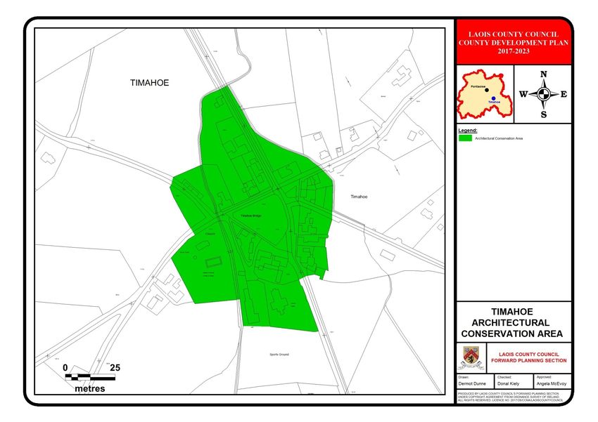
CONTENTS
INTRODUCTION 1
ABBEYLEIX ACA 2
BALLINAKILL ACA 12
CASTLETOWN ACA 18
CLONASLEE ACA 25
DURROW ACA 31
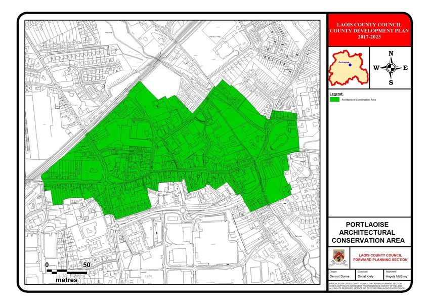
PORTLAOISE ACA 40
TIMAHOE ACA 49
1
INTRODUCTION

    The designation of Architectural Conservation
    Areas (ACAs) arose from recognition of the
    need to protect groups of historic buildings
    and street patterns, as well as individual
    buildings. ACAs are designated to protect the
    special character of an area through positive
    management of change.

    It is Council policy to:

    Consider favorably development proposals
    within an ACA that would either preserve or
    enhance the special character or appearance
    of the ACA. In considering applications for
    changes of use, the Council will be concerned
    with maintaining the character of that area;

    Manage        change    within    Architectural
    Conservation Areas by preserving what makes
    the ACA special, allowing for alterations and
    extensions where appropriate, enhancing the
    quality of the ACA by identifying opportunity
    sites for refurbishment or redevelopment.

    Additional objectives and policies relating to
    ACAs are contained in Volume I

2
ABBEYLEIX ARCHITECTURAL
    CONSERVATION AREA
    .Area
    Setting and General Morphology

    Abbeyleix is located in south County Laois
    within the plain of the Nore River which lies
    about 2.5km to the west of the town. The
    Gloreen Stream runs to the north of the town.
    Abbeyleix is located in a flat rural landscape
    with gently undulating hills located to the east
    and north-east. The surrounding fields are
    demarcated by hedgerows and are used for
    dairying and tillage purposes.

    The present town of Abbeyleix, which is
    eighteenth century in date, was planned on a
    linear axis with the convergence of the main
    thoroughfares at a cross roads in the centre. A
    market place was established immediately to
    the north of the principal crossroads which
    today still acts as the pivotal centre of the
    town. The main commercial area is centred on
    Main Street and Market Square with
    residential areas concentrated on the
    southern portion of Main Street, Stucker Hill
    to the north, New Row/Balladine Row to the
    west and Ballinakill Road to the east.

    History0 HISTORICAL CONTEXT

    The origins of Abbeyleix can be traced back to
    the early medieval period, a church was
    founded in the area during the seventh
    century. The lands formed part of the
    territory of O’Mores, who retained their lands
    during the Anglo-Norman Invasion. The early
    medieval church was re-founded as a
    Cistercian Abbey by Conor O’ More in 1183.

    The place name Abbeyleix derives from an
    anglicisation of the Gaelic name for the abbey
    (Mainistir Laoighise). O’ More granted the
    abbey the lands that now correspond to the
    Parish of Abbeyleix. The establishment of such
    abbeys provided the impetus for the
    development of many Irish villages during the

3
medieval period. The abbeys often controlled          houses were of one-storey construction with
vast swathes of lands that required large             thatched roofs and half-acre back gardens.
numbers of farm labourers and their families          The economic benefits of a successful market
who began to converge in nucleated                    town within their demesnes were recognized
settlements. The Cistercian abbey at                  by the landlords and the development of
Abbeyleix developed into one of the most              commercial activities such as markets, milling
important foundations in the Diocese of               and textile manufacturing were actively
Leighlin during the medieval period. A                pursued by the de Vesci family. Abbeyleix’s
sixteenth century land survey records that the        prosperity in the nineteenth century was
abbey had holdings of 1237 acres when it was          founded on the construction of a centrally
dissolved in 1552. The abbey and much of its          placed market-house in 1836 and a flourishing
lands subsequently came into the possession           textile industry based on wool and yarn
of the Earls of Ormond. It was in use as one of       manufacturing Abbeyleix also benefited from
their residences in 1580 when the buildings           the diversion of the route of the Dublin to
were burnt down by the Earls of Desmond               Cashel mail road through the town. By the
and there are now no visible surviving                1830s the town also contained 140 houses, a
remains.                                              number of schools, a police station, jail, and
                                                      Church of Ireland and Catholic churches.
The riverside village that had developed
around the abbey continued in existence until         While Abbeyleix had prospered in the early
the area came into the possession of the              nineteenth century the need for the
Viscount de Vesci in 1750. The residence of           establishment of a workhouse, a fever
the de Vesci family, Abbeyleix House built in         hospital and an almshouse by the de Vesci’s in
1773 is reputedly built on the site of the            the early 1840s suggests that many families in
abbey. The setting of the village on the              the parish were living in destitute conditions
marshy river bank had led to persistent               even in the years prior to The Great Famine.
problems with flooding and, in the closing            The traumas of the 1840s resulted in
decades of the eighteenth century, the de             amendments to the physical layout of the
Vesci’s decided to level the old settlement           town as a number of works were carried out
and to found a new town at its present                as part of famine relief schemes. The recovery
location.                                             of Abbeyleix in the second half of the
                                                      nineteenth century was in part due to the
The new town was initially named ‘New                 increase in the trading capability of the town
Rathmoyle’, then ‘New Abbeyleix’ and                  resulting from the arrival of the railway
eventually simply ‘Abbeyleix’. The creation of        network in 1867. The town’s textile industry
the new town of Abbeyleix in the eighteenth           continued to thrive until the early decades of
century was an early example of a wider               the twentieth century and the most of the
movement whereby estate towns and villages            thatched roofs of the houses were replaced
were founded in the estates of the newly              with slate at the start of that century.
secure landlord classes. As they were often
designed on a clean slate many of these new           The detail on the Ordnance Survey maps from
settlements were formally planned with                the 1840s onwards indicates that the basic
architecturally unified streetscapes. A wide          layout of the town’s streetscape has remained
linear main street, with a central market and         relatively unchanged up to the present day.
planted lime trees, formed the spine of the           The fortunes of the town as an industrial
new town of Abbeyleix and the original                centre declined during the twentieth century

                                                  4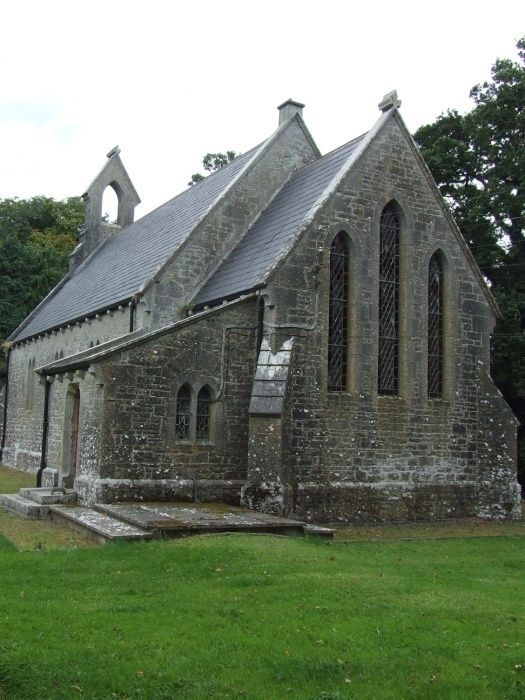
with the closure of many of the textile                the 1830s and 1840s, are to be seen at
industries and the railway station. However,           Pembroke      Terrace.    More     modest
the retention of the essential character of the        Tudor/Gothic revival structures flank the
original estate settlement has resulted in             entrance to Temperance Street.
Abbeyleix being recognised as an important
heritage town.                                         The terraces on the east and west sides of
                                                       main street, to the south of the Market
Architectural Interest                                 Square and incorporating Morrisey’s pub and
                                                       Bramley’s date to the second half of the
The formal design of the town and the                  nineteenth century. While they are modest in
sustained involvement of the de Vesci family           scale they display considerable attention to
over a period of almost 250 years, has                 detail as evidenced by the moulded eaves
resulted in a large proportion of the buildings        brackets, elegant proportions and the many
being of high architectural quality. A range of        fine Victorian shopfronts which still adorn
distinct building styles are represented in the        them.
town. Good examples of late eighteenth to
early     nineteenth       century    Georgian         The Church of Ireland Church on Ballycolla
architecture are to be seen throughout the             Road was built c.1865 and incorporates parts
town with notable examples being Preston               of an earlier nineteenth century church. Both
House, the former courthouse and the Abbey             the 1860s church and its predecessor were
Gate Hotel.                                            designed in the Gothic revival style, the earlier
                                                       building by architect John Semple and the
Also of note from this period is the modest            later by T.H. Wyatt.
Methodist chapel and meeting hall on Main
Street which was built c.1826. The Market              Also dating to the later nineteenth century is
House, whose ground floor colonnades lend it           the Catholic Church of the Holy Rosary which
a somewhat Italianate air, was built in c.1836,        dominates the town from its elevated site to
extensively reconstructed in c.1906 and                the east of the Main Street. The building is a
refurbished in 2009 by De Blacam and                   Victorian interpretation of the Hiberno-
Meagher Architects on behalf of Laois County           Romanesque style and was built in the early
Council.                                               1890s to a design by William Hague.

As the nineteenth century progressed it is             There are fewer examples of notable buildings
likely that some of the older housing stock            as we move into the twentieth century. The
was upgraded and replaced as well as being             Edwardian Bank of Ireland building on the
added to as the town expanded outwards                 east side of Main Street is an exception. It is
from its core. Much of the housing stock               an eclectic mix of styles and is influenced by
within the town dates from the 1830s                   the Arts and Crafts movement. It was
onwards. The continued desire of the de                designed by J.P. Wren in 1909.
Vesci’s to improve the settlement led to the
construction of stylistically unified terraces         Abbeyleix has been fortunate in retaining
                                                       much of its historic fabric and today stands as
which continue to be readily identifiable
today although some incremental loss of                an excellent example of a planned estate
fabric and unifying elements has occurred.             town.
Excellent examples of buildings in the Tudor
revival style, which was particularly popular in

                                                   5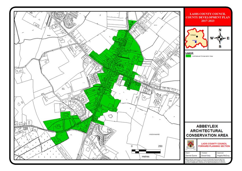
Building Features which contribute to the              Newly constructed buildings tend to be
Special Character of the Town                          higher, or out of scale and are therefore not in
                                                       keeping with the streetscape. They include
                                                       features such as dormer windows and off
Roof, chimneystacks and rainwater goods                centre chimneystacks, found in recent infill
                                                       development in upper Main Street.
Within the town centre, and on all approach
roads, the morphology of the town is                   The majority of chimneystacks are simple in
composed of terraces of buildings in small             design and are either rendered or brick stacks.
groupings separated by laneways. This has              Chimneystacks are placed both centrally and
resulted in there being a range of different           gable ended. Where placed at gabled ends
roof heights along the streetscape.                    they create a strong gable and where centrally
                                                       placed they indicate shared gable walls to
The majority of roofs in the proposed                  terraces. There are a number of tall
Abbeyleix Architectural Conservation Area are          chimneystacks and stepped chimneystacks
pitched. Roof pitches vary but tend to give a          present along the main street which are an
uniform appearance along the streetscape               unusual characteristic. The carved limestone
even though building heights are changeable.           chimneystacks in Pembroke Terrace are highly
Slate covering appears to be dominant on               ornate reflecting the overall appearance of
older buildings but where it has been                  the terrace. The stacks to RPS 74 (inventory
replaced, or where buildings have been                 no. 76) have been replaced in a sensitive
rebuilt, roof covering tends to be artificial          manner showing high quality craftsmanship
slate, fibre cement tiles or clay tiles.               and good conservation practice.

Detached buildings which are also feature              Decorative timber barge boards are confined
buildings tend to have hipped roofs such as            to the school buildings within the town.
the central Market House, A.I.B bank and               Terracotta ridge cresting is found on
Abbeygate Hotel or later infill buildings,             numerous buildings adding to the decorative
including the post office terrace, and terraces        quality of their appearance. Rainwater goods
on Stucker Hill. The central cross road is             are generally cast-iron or cast-aluminium and
defined on three sides by buildings which are          are painted. Replacement rainwater goods
L-shaped and have hipped roofs following the           and those on infill newer buildings are
line of the road. Few buildings deviate from           generally uPVC. Such replacements detract
the pitched or hipped roof form but there are          from the streetscape and the overall
exceptions. Examples include the Bank of               character and appearance of the area.
Ireland where the architectural composition
includes a copper dome, parapet and                    Where present supporting eaves brackets are
projecting gable fronted bay with pediment.            ornate and contribute to the aesthetic
The tudor-inspired gabled projection with              appearance of the building. Good examples
heavy finial at roof level is a feature repeated       include the A.I.B, the terraced buildings on
along Pembroke Terrace and the remaining               Main Street including Bramley’s which display
buildings of Temperance Row.                           finely carved brackets tucked in under over
                                                       hanging eaves. Such features created a
                                                       repetitive feature along the streetscape.
                                                       Similar ornate eaves courses are evident in
                                                       decorative rendering to the Leix Bar and

                                                   6
adjoining building on Main Street. The                  building and its importance to             the
mirroring of such detailing links the                   architectural character of the town.
architectural character of the area adding a
sense of place.                                         Windows and Doors

Render (plasterwork) and external finishes              Despite a high degree of loss, there are a
                                                        variety of traditional window types found
Renders commonly used in Abbeyleix include              within the proposed ACA. Original windows
(a) roughcast or harling and (b) smooth lime            were usually of timber sash construction with
or cement render. Buildings using smooth                the glazing bars providing vertical emphasis.
render are painted with some having a ruled-            In Abbeyleix there are varying window
and lined decoration. Most buildings have a             openings from traditional square-headed,
smooth rendered plinth and some have                    camber headed and feature oriel openings.
channelled quoins which emphasise the                   Like many Irish towns Abbeyleix has
buildings edge while adding visual appeal to            witnessed the replacement of timber sash
the structure. Moulded render detailing is also         windows with uPVC casement windows. Such
used in window and door surrounds and as                replacements are not in keeping with
string and eaves courses highlighting the               traditional design and detract from the
division of storeys and giving vertical                 appearance of the building therefore having a
emphasis to buildings.                                  negative effect on the overall character of the
                                                        area.
The removal of render to expose rubblestone
walls such as at Market Square should not be            The sealing effect created by uPVC windows
encouraged. The carrying out of such works              on historic buildings can lead to the build up
can have a long term detrimental effect on              of condensation and result in the inset of
the condition of the building as exposing the           damp. Replacement timber sash windows
stone to the elements can result in the inset           have been inserted into Bramley’s, Main
of dampness. This is further amplified by the           Street with the removal of an oriel window.
removal of lime mortar and repointing with              This has been carried out in a sympathetic
cement strap pointing. Such work detracts               manner as part of the successful conservation
from the appearance of the individual building          of the building. In doing so the appearance
and the streetscape as it breaks the building           and character of the building has been
line and therefore has a negative effect on the         retained and the building contributes
character of the area as a whole.                       positively to the streetscape. Window
                                                        surrounds add decoration and define the
Deliberately exposed stone construction is              opening and in many cases are simply
evident in the R. C church and Pembroke                 rendered or moulded render, some with
Terrace which display the use of high quality           cornices. This mirrored detailing creates
limestone. The uniform use of dressed stone             harmony along the streets appearance adding
construction and fine cut stone finish to               to the character of the area. In some case this
Pembrook Terrace creates an aesthetically               detailing has been replaced with poor
pleasing group of structures with a strong              alternatives with flat two dimensional
building line. External cut stone is also evident       surrounds.
on the market house where it contributes to
the overall architectural expression of the

                                                    7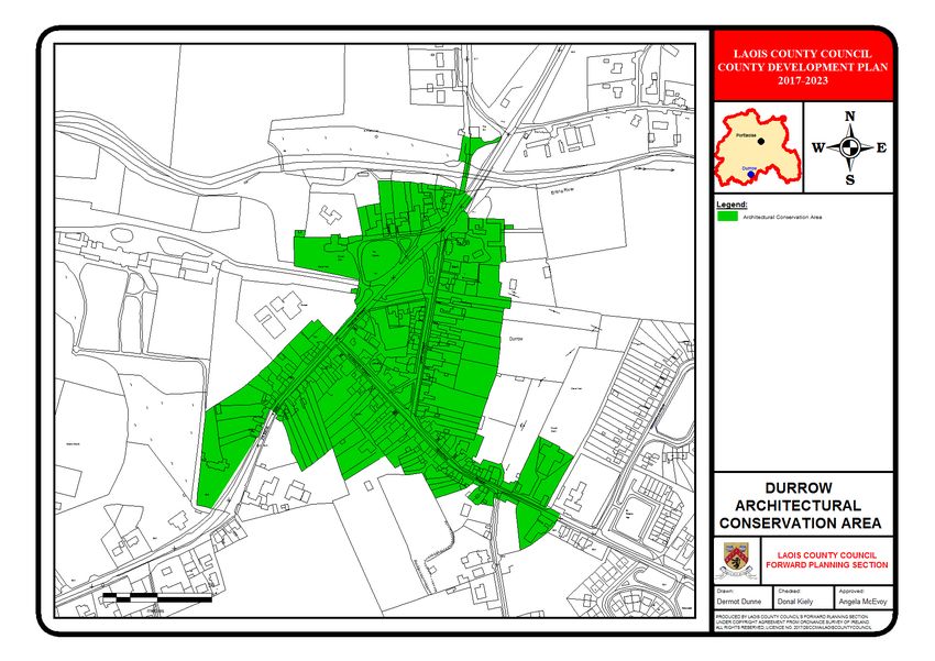
More affluent buildings such as the court                 Replacement doors are often half glazed to
house and those of Pembroke Terrace have                  allow for additional light where overlights or
carved stone window and door openings                     fanlights are not present on more vernacular
displaying work of skilled masons and adding              designed buildings. uPVC replacement doors
considerably to the appearance of the                     are also common.
buildings. The presence of oriel windows is
also found owing to the Tudor revival design              Shopfronts and Advertisement
of the terrace. The presence of oriel windows             The established retail centre of the town
is unusual but it occurs in a few buildings               centres on the market square. Shopfronts are
along the streetscape such as the Leix Bar, the           an integral part of the fabric and texture of
Abbeygate hotel, Costcutter’s and originally              the town and contribute enormously to the
Bramleys, thus providing a repetitive                     historic architectural character of the ACA.
architectural link to the streetscape. It is likely       The surviving traditional shopfronts are
that in some cases the oriels were a later                predominately of timber construction with
nineteenth century modification.                          ornate detailing to the fascia, framing
                                                          pilasters and console brackets. Slender
Window sills in general were constructed of
tooled limestone but in many cases have been              pilasters and consoles are a typical feature of
replaced with concrete sills, often coinciding            many of the nineteenth century shopfronts in
                                                          the town.
with the replacement of windows. Doors
follow the same form and design as windows                Good examples of traditional shopfronts
usually having a vertical emphasis and                    include Leinster House and Mossissey’s, Main
originally being of timber construction.                  Street, and Mooneys, and the Ireland Own
                                                          Antiques, Market Square. The scale and finish
There are a variety of door openings in
Abbeyleix ranging from traditional square-                to earlier shopfronts blend with the street
headed openings, round-headed openings                    architecture lending it a historic patina. Such
                                                          features are an integral part of the character
and larger more ornate segmental-headed
doorcases. Side doors giving access to upper              of the area creating a link to the past and
storeys of buildings along Main Street appear             establishing a unique sense of place.
                                                          Traditional shopfronts are constantly under
to be simple and square or round -headed in
design. Those functioning as the main                     threat     from      modern      replacements,
entrances are more elaborate in nature and                enlargements of display windows or pastiche
                                                          insertions, which can lead to inappropriate
are either round-headed or segmental-
                                                          alteration of the streetscape. New
headed often with fanlights and flanking
sidelights.                                               development should be sensitive to the
                                                          overall character of the area.
Door surrounds to Pembroke Terrace and
Temperance Street are of high quality                     Consideration must also be given to signage
                                                          as it can easily detract from the overall
architectural design with Tudor revival
pointed arched openings which give a                      appearance of a building and its contribution
repetitive pattern to the terrace. At ‘Church             to the streetscape. On the most part signage
                                                          within Abbeyleix is neat and is painted directly
View’ terrace, although the actual doors have
been replaced, door canopies are an unusual               onto the building or fascia. Brash neon or
feature which breaks the monotony of an                   oversized signage can have a detrimental
                                                          effect and be offensive.
otherwise austere terrace.

                                                      8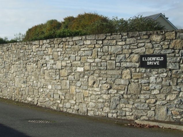
Carriage Arches                                         Roman Catholic Church from the Ballinakill
                                                        road also displays finely executed cast—iron
Carriage arches provided access to backlands            railings and gates creating an impressive entry
behind the main streetscape. They are                   to the church grounds.
intermittently located along the street
creating groups of small terraces and strong            Residential properties on approach roads such
gable ends. Most are integral segmental                 as those on the northern end of main street,
headed arches, which maximise the use of                De Vesci Terrace and properties along the
space by providing a living space overhead              Ballinakill Road are set back from the street
thus balancing the appearance of the building           with a variety of boundary treatments
and providing punctuated openings along the             including rubblestone walls, render walls,
street.                                                 hedging and plinth walls with cast and
                                                        wrought-iron railings atop. Every effort should
Street furniture                                        be made to retain these boundary
Sometimes heritage items in the public realm            treatments. Traditional stone wall boundary
are the easiest to preserve and yet the most            treatment such as those behind Pembroke
vulnerable to carelessness. Abbeyleix retains a         Terrace, Ballacolla Road and to the north-east
number of items of historical street furniture          of the church are constructed with locally
which add to its character. A pillar box located        quarried stone and are of rubble construction.
at the southern end of Main Street is                   They form a definite strong line and help
Edwardian in date and shows high-quality                delineate the original boundaries of the town
cast-iron detailing which gives this item of            and therefore the ACA.6
street furniture artistic and technical interest.       ACA Boundaries
The adjacent water trough is a reminder of
the former use of horse and cart for transport          When assessing Abbeyleix for ACA
before high car dependency. A wheel guard               designation the boundary was drawn up using
remains just east of the cross roads on the             the architectural heritage guidelines to ensure
Ballinakill    road.      Four     finely-crafted       a legible and meaningful boundary was
commemorative water fountains located at                created to protect the unique character of the
strategic points within the town create focal           town. Those areas excluded from the ACA
points within the public realm.                         were viewed as being too recent in nature or
                                                        did not contribute to the special character of
Railings and Boundary Walls                             the area.
Most properties in the town core front                  Summary Character Statement
directly onto the street and therefore lack
boundary treatments. In contrast to this some           Constructed in the late eighteenth century as
architecturally designed structures are                 a formally planned town, Abbeyleix did not
purposely set back from the street with strong          evolve over a long period of time like most
boundary      treatments.      These      include       Irish towns and villages. The town was
Pembroke Terrace, Preston House, Epworth                planned on a linear axis with the convergence
Hall, the Court House and the Bank of Ireland,          of the main thoroughfares at a cross roads in
the use of cast-iron railing on a low plinth wall       the centre. The location of the market place
creates     deliberate      separation      while       immediately to the north of the principal
simultaneously allowing the building to be              crossroads creates the pivotal centre of the
viewed and appreciated. The entrance to the             town.

                                                    9
The high quality of architecture is particularly contribute to the architectural quality and
evident in the buildings lining the main square character of Abbeyleix.
and along the main street. The designed
layout is comprised of two storey structures In addition to these significant buildings there
are designed terraces which share repetitive
grouped together in small terraces with
intermittent laneways, integral carriage patterns of roof pitches, chimneystacks, door
arches and long narrow burgage plots to the and window openings giving the streetscape a
sense of harmony and scale. Most notable are
rear of the buildings. A relatively large
number of traditional shop fronts survive, the ‘Pembroke Terrace’ and ‘Temperance Street’
majority of which display a high level of (partially demolished). Such fine terraces are
of both national and regional importance and
craftsmanship in their design and finish. This
create a pleasing focal point as the town is
creates an aesthetically appealing appearance
which contributes to the overall visual entered from the south. The same repetitive
perception of the town and in turn the pattern is mirrored on New Row but in a more
vernacular design in ‘Church View’ terrace
character of the ACA.
whose door canopies created a symmetrical
The buildings in close proximity to the market rhythm along the streetscape.
square form the basis for the town’s
commercial and financial centre. They include The urban pattern and morphology of the
town is defined by residential terraces of
individual structures such as the market
house, court house and banks. These houses located on the approach roads which
buildings are of high architectural value and are more traditional in design and finish. In
turn as one moves closer to the town’s centre
have been designed and finished to a high
quality. Repeated features such as the use of the buildings change and take on the dual
stone finishes for window sills, steps, eaves function of commercial and residential. The
town centre is defined by the presence of the
and string courses create a linked appearance
and a sense of harmony to the town centre. market square and number civic buildings
There are numerous detached civic buildings which give a firm definition of urban place.
Apart from the central market house there
of architectural significance dispersed
throughout the town. At the northern limit of are a number of prominent buildings of high
the ACA boundary, for example, is the architectural quality on the main street such
as the Bank of Ireland and Allied Irish Bank
landmark former North National School, now
the heritage centre. This building has been which create focal points along the
extended over time and sensitively renovated streetscape.
to remain an important building within the The full appraisal has identified 109 structures
town. The Roman Catholic Church located on within the ACA boundary which add to the
an elevated site creates a prominent feature character of the town.
in the centre of the town.
A grouping of buildings including the Church Implications of ACA designation
of Ireland church, South National School,
Sexton’s House and the former railway station Within an ACA, there are restrictions on
are located on the south-west fringe of the certain works to exteriors of structures. In
town and all are listed on the record of addition to the usual requirements of
protected structures. These structures planning law, the designation means that
works that would materially affect the special
10character of the ACA will need planning particular area special. The demolition or
permission. In practice, this would mean that insensitive alteration of structures that make
the removal of historic building fabric and its a positive contribution to the ACA will not be
replacement with modern materials will permitted. Some structures within the
require planning permission. boundaries may be of little architectural
interest and are included within an ACA
For example the removal of sliding sash boundary only because of their location
windows and their replacement with uPVC within the streetscape. Buildings of little
windows will require planning permission. If architectural merit may be subject to
uPVC windows are already in place, their wholesale redevelopment as part of a
replacement will not require planning planning permission. However, any
permission. replacement building should be designed with
• Other works that would require permission due regard to the special characteristics of the
include: ACA. Suitably designed infill or bankland
development that contributes to the special
• the stripping of render from a building to
character of the ACA will also be encouraged.
expose stonework
Works to the public realm within ACAs e.g.
• the cladding of a building with stone or
footpaths, street furniture, parking schemes
timber
will be required to respect the special
• the removal of cast iron rainwater goods,
character of the area also.
the removal of a natural slate roof
covering
• the removal of chimney stacks or changes
to the roof profile
• the removal of limestone sills
• changes to the window proportions
• the addition of porches
• other extensions that would impact on the
front elevation of the buildings
• the removal of historic shopfronts or
elements thereof
• the installation of roller shutter blinds
• the removal of historic boundary walls or
railings.
Planning permission is not required for
regular maintenance works and repairs, as
long as original materials are retained where
they exist and where replacement is
necessary (for example due to rot) that it is on
a like-for-like basis.
The intention behind the designation is not to
stop change, but to manage the nature of the
change in order to respect and enhance the
features and characteristics that make a
1112
BALLINAKILL ARCHITECTURAL
     CONSERVATION AREA
     History

     Ballinakill is located in south County Laois. The
     name Ballinakill is thought to derive from
     “Baile na Coillte” meaning the town of the
     wood. The hinterland around Ballinakill
     remains well-wooded.

     The town dates to the seventeenth century. In
     1606 the right to hold a market and fair at
     Ballinakill was granted. Originally part of the
     Cosby Estate, lands were granted to Thomas
     Ridgeway in 1611 and an English colony was
     established there soon after. Ridgeway is said
     to have spent £10,000 in the creation of the
     town. In 1613 the town was incorporated by
     charter. The economic development of the
     town was underpinned by its proximity to
     ironworks located to the southeast of the
     town on the Ironmills River, a tributary to the
     Owenbeg River where the Ironmills Bridge
     spans the River.

     In 1631, the town was said to contain a large
     castle, one hundred dwelling houses, a fulling
     mill (a step in woollen cloth making), two
     water mills, the iron mill referred to above,
     three fairs and two markets. In 1642, the
     town is described as: seated among woods in
     a place so watered with springs as afforded
     the Earl convenience to make many fish ponds
     near the castle he built there; which he
     likewise fortified with a strong wall and that
     with turrets and flankers; besides that, the
     town since it had been planted was well
     inhabited

     The castle referred to above was built
     between 1605 and 1613 and destroyed in the
     mid-seventeenth century. This Castle was
     initially used to defend territory against the
     Confederates (Irish Catholic Confederation
     who governed parts of the country
     independently following the 1641 rebellion)
     with settlers flocking there for refuge when
     the rebellion broke out. The Castle withstood
     initial attacks but ceded to the Confederates
     when it came under attack by heavy artillery.

13
All of Laois came under confederate control Plan form
by 1643 and the Castle was used as a garrison
in 1646. The Castle was surrendered to In the seventeenth century the street plan of
Cromwellian forces in 1650 and seemingly Ballinakill was laid out along the long access
destroyed. The Castle was a substantial formed by Graveyard Street and Stanhope
structure with a water-filled moat, gatehouse Street with Chapel Lane and Castle Lane
and clock tower. The ruinous remains of what running perpendicular to the east. The current
is known locally as Ballinakill Castle was built large rectangular urban space known as The
in 1680 by the Dunnes, of roughly coursed Square and the related Church Street to the
pink shaly stone with dressed limestone north and Bridge Street to the west are an
quoins. The structure was originally five eighteenth century addition. The more
storeys in height; the extant structure is three sinuous seventeenth century is quite distinct
storeys in height and retains features such as from the more geometric eighteenth century
ground and first floor gun loops and a second addition on aerial photographs of the town. A
floor window. well-defined burgage plot pattern is
discernible on the east side of Stanhope
By 1659 the town was the third most Street and the Square. Parts of the building
populous in Laois and the population was one fabric in this area may be seventeenth century
quarter English. By the eighteenth century, it in date, the area is within the Ballinakill zone
was one of the most importance fair towns in of archaeological potential.
the County. In 1801 it was a major tanning
and brewing centre and also featured a small
woollen business. The corporation and
borough of Ballinakill were dissolved with the
Act of Union in 1800.
Gate lodges to Heywood Demesne
Influence of Heywood Demesne
Seventeenth century plan form
Ballinakill is closely associated with the
Heywood Demesne. The Demesne dates back
to the eighteenth century. The house and
gardens were designed by the owner and
amateur architect MF Trench, who adorned
the sites with follies salvaged from medieval
sites. In the nineteenth century the house was
significantly altered and was eventually
destroyed in the 1960s. In the 1920s Edwin
Lutyens designed the landscape around the
house. It survives and comprises a sunken
Eighteenth century streetscape and plan form
garden, ornamental pond and fountain within
elliptical flowerbeds and terraces. Gertrude
Jekyll devised the planting scheme.
Most of the laneways on the 1841 Ordnance
Survey map linking the town with the
14Heywood Demesne remain. However, a on the Square appear neglected and would
laneway to the east of the Square, the north benefit from more active uses. Features to
of Chapel Lane and the Mass Lough no longer townhouses on the Square include rusticated
directly connects these spaces. A direct route ground floors, semi-circular fanlights to front
from the Mass Lough to The Square has now doors and faux plaster quoins.
partially disappeared and is now a short
laneway to the rear of commercial and
residential properties.
Building features: chamfered, faux quoins; raised plasterwork
window surround with keystone detail and wrought iron railings
to front; natural slate roof and caste iron hopper
Fine Georgian House
Traditional shopfront with stained glass lantern, with living
quarters to the side and above
Backland view of ruinous towerhouse, Roman Catholic Church
and Church of Ireland spire
Architectural Interest
Much of the extant building stock of
architectural interest in Ballinakill is
eighteenth century in date. High order
buildings overlook the square and more Market House and Market Square
modest buildings are located to the south and
east. Fine individual structures include the
gatehouses to the Heywood Demesne along
Church Street to the back of the Heywood
Demesne, the Georgian Gothic Church of
Ireland (1821) and the Gothic Revival Roman
Catholic Church (1835) and two detached late
nineteenth century schools also on Church
Street. Some of the late Georgian structures
and mid to late nineteenth century structures
15works that would materially affect the special
character of the ACA will need planning
permission. In practice, this would mean that
the removal of historic building fabric and its
replacement with modern materials will
require planning permission. For example, the
removal of sliding sash windows and their
replacement with uPVC windows will require
planning permission. If uPVC windows are
already in place, their replacement will not
require planning permission.
Other works that would require permission
include:
• the stripping of render from a building to
expose stonework
• the cladding of a building with stone or
Toll Trees
timber
• the removal of cast iron rainwater goods,
Although the Square retains a strong and the removal of a natural slate roof
cohesive character with the Market House to covering
centre, many of the sliding sash windows and • the removal of chimney stacks or changes
also the natural slate materials have been to the roof profile
replaced with unsympathetic modern • the removal of limestone sills
materials. The Square would benefit from • changes to the window proportions
more sympathetic treatment, it is currently • the addition of porches
finished with concrete slabs, tarmacadam and • other extensions that would impact on the
red brick. The toll trees at Church Street front elevation of the buildings
frame the approach into Ballinakill and • the removal of historic shopfronts or
contribute to its special character. The setting elements thereof
of the village against the wooded Heywood • the installation of roller shutter blinds
Demesne, encompassing the Mass Lough and • the removal of historic boundary walls or
related esker are an essential part of the railings.
village’s character.
Planning permission is not required for
Boundaries regular maintenance works and repairs, as
long as original materials are retained where
The ACA boundary is focused on the they exist and where replacement is
seventeenth and eighteenth century village necessary (for example due to rot) that it is on
centre. While many buildings within the ACA a like-for-like basis.
are of architectural merit, some buildings of
little or no architectural merit may be The intention behind the designation is not to
included within the boundaries because of stop change, but to manage the nature of the
their location within the historic streetscape. change in order to respect and enhance the
features and characteristics that make a
Implications of ACA designation particular area special. The demolition or
insensitive alteration of structures that make
Within an ACA, there are restrictions on a positive contribution to the ACA will not be
certain works to exteriors of structures. In permitted. Some structures within the
addition to the usual requirements of boundaries may be of little architectural
planning law, the designation means that interest and are included within an ACA
16boundary only because of their location
within the streetscape. Buildings of little
architectural merit may be subject to
wholesale redevelopment as part of a
planning permission. However, any
replacement building should be designed with
due regard to the special characteristics of the
ACA. Suitably designed infill or bank land
development that contributes to the special
character of the ACA will also be encouraged.
Works to the public realm within ACAs e.g.
footpaths, street furniture, parking schemes
will be required to respect the special
character of the area also.
1718
CASTLETOWN ARCHITECTURAL
     CONSERVATION AREA

     History

     Castletown reportedly takes its names from a
     Norman twelfth century castle of which only
     fragments remain. The development of the
     village   is     associated      with    the
     MacGiollapadraigs.

     In the late twelfth or early thirteenth century,
     the MacGiollapadraigs (Fitzpatricks) were
     displaced from lands to the south and made a
     common cause with the Delaney’s seizing the
     Norman castles at Castletown, Aghaboe and
     Borris in Ossory. The MacGiollapadriags were
     one of the seven tribes of the Laoighis,
     claimed descendence from the Milesians
     (Celts) and are attributed in the rebuilding of
     the fourteenth century monastery at
     Aghaboe. In the early fourteenth century, the
     remnant foreign settlers within the
     MacGiollapadrig’s territory were expelled.

     There is little documentation and study
     related to the planatation of the Upper Ossory
     the barony in which Castletown is located or
     the origins of the Castletown settlement.
     Castletown and the surrounding area were
     reportedly burned in 1600 to prevent royal
     forces taking succour. The crown made a
     largely spurious claim to this territory and
     proceeded with its plantation following an
     inquisition in 1621. Large-scale land seizures
     from      the     dominant       family     the
     MacGiollapadraig’s were made in 1626 and
     this included the Castletown estate. The
     MacGiollapadriag’s disputed the seizures,
     arguing that Elizabeth I had previously assured
     them that the Castletown estate would
     remain      in    their     possession.     The
     MacGiollapadrig’s ceded territorial supremacy
     to the Duke of Buckingham in 1627. A
     reportedly apocalyptical preacher Olmstead
     received more than 500 acres of former
     MacGiollapadriaig land in and around
     Castletown.      Evidence      suggests     the
     MacGiollapadraigs       became     increasingly

19
impoverished as a result of their loss of This history of Castletown in Upper Ossory is
territory. sometimes confused with Castletown near
Killabban in the east of the county which was
During the 1641 revolt, the an important settlement in Norman times and
MacGiollapadriagns and other families is associated with Hugh de Lacy.
rejected the plantation siding with the
Conferderates and were central to the siege Architecture – Description of Special
of Birmingham’s castle in Borris in Ossory. In Character
1642 the MacGiollapadraig’s laid siege, but
had little success because of a lack of artillery. Castletown, is described in the Topographical
Dictionary of Ireland of 1837 as a village
pleasantly situated on the River Nore and on
the road from Dublin to Limerick, taking its
names from an ancient castle containing 59
houses, many of which are good residences
and the whole has an appearance of neatness
and respectability. Based on urban
morphology typologies, the village’s layout
Bawn: above elevation
around a central triangular green is
overlooking River Nore seventeenth century in date.
with gun loops; left
western elevation with The land falls from south to north afforded
intermural entrance and
panoramic views of the wider landscape and
battered wall
the Slieve Blooms from the green.
A bawn is located above the south side of the
river. The elevation overlooking the river
comprises roughly coursed cut stone wall with Castletown Green retains a strong Georgian
gun loops and square pillars and two terraces character. Buildings of a high architectural
with similar pillars. An intermural entrance order, with good survival of original
with associated steps is located to the architectural features such as windows and
northwest corner. The western elevation is of rainwater goods, overlook the triangular
similarly roughly coursed but has a curved central green with its mature horse chestnut
batter of random rubble and rounded stone. trees.
This bawn appears defensive in nature and is
strategically sited overlooking a navigable Early Georgian buildings are of particular
watercourse which would have functioned as interest, some have pitched-gables and others
an importance trading corridor. It may be hipped-gable pitches, the larger properties
associated with the MacGiollapadraig’s and tend to have integrated carriageway
the late medieval period. Further survey and entrances and double pitches. Some later
study of this monument is needed.
20structures dating to the 1830s at the Green
are more modest.
The Corn Mill (1840) (above) of coursed
limestone rubble, dressed in brick with
limestone quoins, slate roof, red ridge tiles
and cast iron rainwater goods is a landmark
building. As suggested by its location adjacent
to the River, it was water-powered and the
mill race, weir and steps along the southern
side of the river bank are extant. The bridge
spanning the river is sizable and can be
Notable nineteenth century additions include appreciated from the banks, it is ornamented
the rendered De La Salle Monastery (1870) by cast iron lanterns. The mill structure is now
(below) with red clay crested ridge tiles, vacant.
yellowbrick chimneystacks and profiled cast
iron rainwater goods. The Monastery Twentieth century structures include the two
dominates the green because of its large scale school buildings from the first half of the
and the topography of the Green. twentieth century and a social housing estate.
21The double row of trees and the six-arch • the stripping of render from a building to
limestone bridge (1750) with rubble stone expose stonework
parapets provides a fitting entrance to the • the cladding of a building with stone or
village and can be appreciated from the
timber
grassed river banks below. The village has a
tidy and well-maintained feel. • the removal of cast iron rainwater goods,
the removal of a natural slate roof
The village retains a strong geographic covering
relationship to the river, though with the • the removal of chimney stacks or changes
exception of the mill and the bawn, the to the roof profile
buildings do not address the River.
• the removal of limestone sills
Castletown would have benefited from its • changes to the window proportions
location close to a navigable river which • the addition of porches
would have been used to transport • other extensions that would impact on the
agricultural produce from the hinterland and front elevation of the buildings
other bulky goods. • the removal of historic shopfronts or
elements thereof
The current commercial uses are located in
the adjacent street giving The Green a • the installation of roller shutter blinds
tranquil atmosphere comprising residential • the removal of historic boundary walls or
and institutional uses. railings.
The ACA boundaries are focused on the Green Planning permission is not required for
and the river. regular maintenance works and repairs, as
long as original materials are retained where
Implications of ACA designation they exist and where replacement is
necessary (for example due to rot) that it is on
Within an ACA, there are restrictions on
a like-for-like basis.
certain works to exteriors of structures. In
addition to the usual requirements of The intention behind the designation is not to
planning law, the designation means that stop change, but to manage the nature of the
works that would materially affect the special change in order to respect and enhance the
character of the ACA will need planning features and characteristics that make a
permission. In practice, this would mean that particular area special. The demolition or
the removal of historic building fabric and its insensitive alteration of structures that make
replacement with modern materials will a positive contribution to the ACA will not be
require planning permission. permitted. Some structures within the
boundaries may be of little architectural
For example the removal of sliding sash
interest and are included within an ACA
windows and their replacement with uPVC
boundary only because of their location
windows will require planning permission. If
within the streetscape. Buildings of little
uPVC windows are already in place, their
architectural merit may be subject to
replacement will not require planning
wholesale redevelopment as part of a
permission.
planning permission. However, any
• Other works that would require permission replacement building should be designed with
include: due regard to the special characteristics of the
ACA. Suitably designed infill or bankland
22development that contributes to the special
character of the ACA will also be encouraged.
Works to the public realm within ACAs e.g.
footpaths, street furniture, parking schemes
will be required to respect the special
character of the area also.
2324
CLONASLEE ARCHITECTURAL
     CONSERVATION AREA

     History

     Clonaslee originated as an Anglo-Norman
     settlement, though detail of its development
     during the late medieval period is scant. Its
     name is thought to derive from Cluain na
     Slighe, roadwise meadow or Cluain na Sleibhe,
     mountain meadow.

     The development of the estate village of
     Clonaslee is associated with the Dunne family
     (of Irish descent) and the Brittas Estate.
     During the Williamite wars, soldiers from
     James I’s army are said to have been based at
     Clonaslee in 1691, as the Dunne family were
     supporters of James Ist.

     The Dunne’s country house was built in 1869
     to designs by John McCurdy, then extended
     and altered by Millar and Symes in 1879 and
     comprised three-storey over basement tower.
     The house was built by General Dunne then a
     Member of Parliament. The building is now
     derelict as a result of a fire in 1940s with no
     roof to the main structure. The appearance of
     the flag tower remains striking, being of
     sandstone ashlar masonry with defensive
     features including buttresses, corbelled,
     castellated parapet and a castellated turret
     and ornamented windows dressed in
     sandstone. A detached gatehouse and
     detached outbuildings forms part of the
     estate. The sandstone gate piers to the estate
     are sited within the village, tangibly indicating
     the close relationship between the demesne
     and the village.

25
thatched chapel built around 1771 by Francis
Dunne who became a Catholic.
Gates to Brittas Demesne
As with many estate villages, it is arranged
around a wide boulevard. The plan form is
thought to be eighteenth century in date. The The village grew quickly between 1800 and
former Church of Ireland (1814) is constructed 1830. This growth was due to making of The
in a Georgian Gothic style and is given central Cut through uplands to create a new road
importance within the streetscape: the vista between Mountmellick and Birr. This period
created by the strong building line of the saw the arrival of services such as a Post
boulevard terminates with the Church and is Office and Police Station. The current urban
punctuated by the square tower and tall spire form of the centre of Clonaslee very much
above. The church was erected under General resembles its appearance in the first ordnance
Dunne, aided by a grant from the Board of survey map in 1841. Clonaslee suffered severe
First Fruits which was set up by Queen Anne population decline during the famine. The
to improve churches and glebe (rectory) settlement has expanded eastwards and now
houses. functions as a large village.
Main Street Clonaslee
The Green, Clonaslee
Tullamore Road Clonaslee
The Roman Catholic Church, Saint Manman’s
(1813) is located on the Tullamore Road and is
set back from the road and is simplier in
design. It is located on the site of an earlier
26Cast iron hopper
Painted timber shopfront
Clodiagh River Gaps between the buildings provide shared
access to backlands though a few integral
carriageways exist also. Most of the buildings
have no elevational decoration, some are
decorated with painted raised plasterwork to
the doorways and faux quoins to the edges.
Elevational finishes include roughcast, lime
render and cement renders. Much of the
original building fabric such as doors, sliding
sash windows, roof tiles and rainwater goods
The topography of the village is flat and is set have been replaced. Chimney stacks and pots
in a landscape dominated by gentle uplands generally survive. A small number of
and mature woodlands. The Clodiagh River shopfronts of architectural quality survive.
runs along the Tullamore Road enclosed by a The roof heights and pitches vary along the
stone wall and under the Main Street towards Main Street within a small range. More
Brittas Lake and contributes to the special generally the streetscape comprises a linear
character of the village. The streetscape of form, designed vistas and views and some fine
Main Street is cohesive, incorporating a strong individual buildings including the Church of
building line defining the edge of the street, Ireland which now functions as a Heritage
the buildings are mostly two-storey, with wide Centre, the Lodge and Hickey’s Public House
frontages, gable-pitched roofs, large chimney with their decorative timber fascia boards, the
stacks and vertical emphasis windows, are defunct Courthouse overlooking the Green.
orientated towards and open directly onto the The Swan Public House, though not of
Main Street. architectural interest, is a prominent building
by reason of its siting.
Typical elevation Typical elevation
Shared access Stone outbuilding
27For example the removal of sliding sash
windows and their replacement with uPVC
windows will require planning permission. If
uPVC windows are already in place, their
replacement will not require planning
permission.
• Other works that would require permission
include:
Open spaces make an important contribution
to the character of the village and comprise • the stripping of render from a building to
the Green and the open space to the front of expose stonework
Hickey’s Public House known as the Square. • the cladding of a building with stone or
timber
Buildings along the western side Tullamore • the removal of cast iron rainwater goods,
Road are more informally arranged becoming
the removal of a natural slate roof
single-storey cottages from the village and are
generally of a lower architectural order. The covering
cottages along this road contribute to the • the removal of chimney stacks or changes
special character of the ACA. The buildings to the roof profile
and open spaces of the village are generally • the removal of limestone sills
well-maintained. • changes to the window proportions
• the addition of porches
Boundaries
• other extensions that would impact on the
The ACA is focused on the historic core of front elevation of the buildings
Clonaslee which comprises the Main Street, • the removal of historic shopfronts or
the Green and the Tullamore Road. While elements thereof
many buildings within the ACA are of • the installation of roller shutter blinds
architectural merit, some buildings of little or • the removal of historic boundary walls or
no architectural merit may be included within railings.
the boundaries because of their location
within the historic streetscape or setting of Planning permission is not required for
the village. regular maintenance works and repairs, as
long as original materials are retained where
Implications of ACA designation they exist and where replacement is
necessary (for example due to rot) that it is on
Within an ACA, there are restrictions on
a like-for-like basis.
certain works to exteriors of structures. In
addition to the usual requirements of The intention behind the designation is not to
planning law, the designation means that stop change, but to manage the nature of the
works that would materially affect the special change in order to respect and enhance the
character of the ACA will need planning features and characteristics that make a
permission. In practice, this would mean that particular area special. The demolition or
the removal of historic building fabric and its insensitive alteration of structures that make
replacement with modern materials will a positive contribution to the ACA will not be
require planning permission. permitted. Some structures within the
boundaries may be of little architectural
28interest and are included within an ACA
boundary only because of their location
within the streetscape. Buildings of little
architectural merit may be subject to
wholesale redevelopment as part of a
planning permission. However, any
replacement building should be designed with
due regard to the special characteristics of the
ACA. Suitably designed infill or bankland
development that contributes to the special
character of the ACA will also be encouraged.
Works to the public realm within ACAs e.g.
footpaths, street furniture, parking schemes
will be required to respect the special
character of the area also.
2930
DURROW ARCHITECTURAL                                    local place names, such as ‘Bishop’s
                                                        Meadows’, ‘Bishop’s Roads’ and Bishop’s
CONSERVATION AREA                                       Woods’. The Earl of Ormond was granted
                                                        possession of the manor following the
                                                        Reformation. Durrow was officially removed
Location and General Morphology                         from the jurisdiction of Queen’s County and
                                                        transferred into Kilkenny during the 1680s.
Durrow is located in south County Laois in a
rural landscape of gently undulating hills, the         The estate was rented by the Viscount of
River Erkina skirts the northern boundary of            Ashbrook, Sir William Flower in the same
the village and the former main road to Dublin          decade, and was then released to the Flower
bisects the village diagonally. The village of          family in 1708. The estate of Castledurrow
Durrow centres around the pattern created by            remained in the ownership of his descendants
the convergence of two roads; the main (N8)             until the early twentieth century. The
route running from Dublin on the north east             construction of Castledurrow was completed
to Urlingford and Cork beyond on the south              in the 1730s and by the end of the eighteenth
west, and the road to Kilkenny (N77) in the             century the earlier settlement of Durrow had
south east. These three main approaches                 been replaced with a planned estate village of
create the basis for the triangular                     218 houses.
arrangement of Old Chapel Street, Mary
Street and Castle Street and this coupled with          The new village was centred on a large square
the open ‘Square’ in front of the entrance to           located to the east of the grounds of
the settlement’s principal raison d’etre,               Castledurrow and they were connected by a
Durrow Castle, give Durrow the well defined             tree-lined avenue that ran along the north
layout of a planned estate village.                     end of the walled estate gardens. A number of
                                                        three storey buildings to the north of the
History                                                 square were constructed by Flowers for his
2.0 HISTORICAL CONTEXT                                  Welsh and English estate managers. The
The place name Durrow is an anglicisation of            leases for the village plots made available to
Dar Magh (‘the plain of the oaks’) and the              settlers prescribed the exact location and
earliest reference to the area is in the fifth          dimensions of the houses to be built and the
century. There are also references to a                 timescale for the completion of construction.
monastery founded in Dervagh during the                 A number of leases were also granted for the
sixth century.There are no remains of this              milling operation at the Course on the Erkina
monastery but the Record of Monuments and               during the eighteenth century and milling
Places (RMP) records an ecclesiastical site             continued at this site until 1929.
(LA029-042000) on the south side of the
Erkina river and on the western outskirts of            A stone bridge was constructed to the north
the present day town. The association of St             of the square in 1788 to replace an existing
Fintan with Durrow is commemorated by a                 wooden bridge reputedly located c.500m up
holy well (LA029-043001) dedicated to him on            river and was itself replaced in 1958. The new
the north bank of the river. A number of                estate town at Durrow benefited from its
derivations of the place name Durrow can be             location on the Cork to Dublin mail road and
seen in other historical references to the area.        the ‘The Red Lion’ hotel, which was
A grant issued in 1245 to Geoffry de Turville,          constructed in the 1790s, functioned as a
Bishop of Ossory, to hold a weekly market and           halting station for the Bianconi coaches.
an annual fair at the manor of Derevald. In
1350 the Manor of Deraugh was listed as the             In his 1837 description of Durrow, Samuel
most valuable of the temporalities of the See           Lewis records that the town’s population at
of Ossory. The manor remained in the                    that time was 298 inhabitants and that many
possession of the bishops until the                     of its 236 houses were well-built and roofed in
Reformation and their influence is reflected in         slate. There were weekly markets held at the

                                                   31
You can also read