DESCRIPTION OF THE PROJECT - PART C - NZTA
←
→
Page content transcription
If your browser does not render page correctly, please read the page content below
PART C

DESCRIPTION
OF THE
PROJECT
Assessment of Effects on the Environment Report                Section 6: Description of the Project

6.0        Description of the Project
Overview

This section includes the Project Description which provides the basis for the assessment of effects on
the environment in Part G: Assessment of Effects on the Environment of this AEE. It includes a description
of design and form of the Project and how the Project will be operated once construction is complete.

6.1       Introduction

This Project description provides the basis for the assessment of effects on the environment. It includes
a description of the key physical elements of the Project and how different aspects of the Project will be
operated once construction is complete.

Given the integrated nature of the Project, the description provides a brief overview of the transport
elements of the Project and the wider open space, water and environmental elements. This is followed
by a description of the Project’s physical works within each of the six sectors.

The transport elements of the Project are described in terms of the following aspects:
·     The State highway environment and local roads, other transport modes;
·     A summary of the key features including: major structures, interchanges, acoustic barriers;
·     Traffic function; and
·     Design approach.

In addition, the wider integrated elements of the Project are described in terms of the social,
environmental and cultural outcomes they deliver. In particular, these relate to the:
·     Open space and recreation outcomes (public access);
·     Water quality outcomes (the receiving environment including the CMA); and
·     Wider environmental / cultural restoration / rehabilitation outcomes.

The second part of this section provides a description of design elements specific to each of the six
sectors described in Section 6.6: Physical description – Project sectors of this AEE. The section also
highlights how this Project integrates with other transport network-related projects in the wider area in
Section 6.7 of this AEE.

The information provided in this section is indicative and is intended to provide sufficient detail on the
Project to assess the actual and potential effects and to identify any necessary measures to avoid,
remedy, or mitigate any adverse effects, where appropriate.

The design will be further refined, through subsequent phases of the Project. This will be undertaken
within the scope of the final designation and consent conditions which will have been put in place to
manage the effects on the environment. The detailed design of the Project will be reflected in the Outline
Plan(s) and other documentation submitted to Auckland Council prior to construction. Further discussion
on the Outline Plan process is provided in Section 13.1.2 of this AEE.

6.2       Overview of key features

At its core, the Project seeks to provide transport outcomes to meet the Transport Agency’s objectives
for the Project as set out in Section 3.3 of this AEE. In delivering these outcomes, the Project has also

                                                                              December 2016 | Revision 0 | 44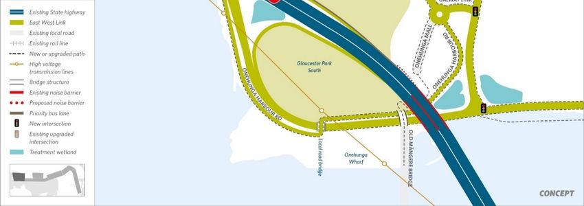
Assessment of Effects on the Environment Report Section 6: Description of the Project
sought to integrate with wider social, environmental and cultural outcomes and aspirations for the area.
This integrated approach is core to the Project, but also means that some components of the Project are
beyond the defined transport outcomes. As a summary, for each of the design features described,
reference is made to whether these are contributing to transport, public access, water quality and/or wider
environmental/cultural outcomes.
The principal design features are addressed in the sections below.
6.3 Transport environment
6.3.1 New State highway
The Project involves the establishment of a new section of State highway generally between existing
SH20 and SH1. The new State highway will comprise all parts of the alignment where the primary function
is State highway and will likely be gazetted as State highway on completion. This will include:
· All ramps onto and off the Neilson Street Interchange and the alignment where it passes to the north
of the Onehunga Wharf;
· The Main Alignment adjacent to the Māngere Inlet foreshore;
· Viaducts over Anns Creek and the intersection with Great South Road;
· Connections from the Main Alignment to Great South Road and Sylvia Park Road and the alignment;
· Sylvia Park Road; and
· New SH1 on and off-ramps at Mt Wellington.
Where the alignment ties into local roads, these will be designated for State highway purposes as far as
physical works are required. In due course the designation will be uplifted to cover the gazetted State
highway, with the balance of any works becoming part of the local road network. This is described further
in Section 6.3.4 of this AEE.
The new State highway will operate as an arterial road environment, enabling local road connections,
walking and cycling paths, and crossings at some intersections. The majority of the State highway will
comprise two lanes in each direction with shoulders, raised median, and separated walking and cycling
paths on either side.
6.3.2 SH1 alignment and capacity improvement
The Project will increase capacity on SH1 between the Mt Wellington Interchange and just south of the
Princes Street Interchange by adding one additional lane in each direction on the existing motorway. The
additional lanes will have adjacent shoulders and vertical retaining walls on the outer edges. The
additional lanes merge from new south-facing ramps providing access between the Main Alignment and
the SH1 corridor. Where the new State highway joins SH1, the southbound on-ramp will comprise two
lanes that enable ramp metering, merging into a single lane prior to joining into the new auxiliary lane on
SH1. The northbound off-ramp from SH1 includes an improved Mt Wellington Highway off-ramp, with the
Project connection coming off this ramp. The new EWL/Great South Road/ Sylvia Park Road intersection
will provide long term benefits by providing grade separating the east west connections improving
reliability and future resilience for this intersection.
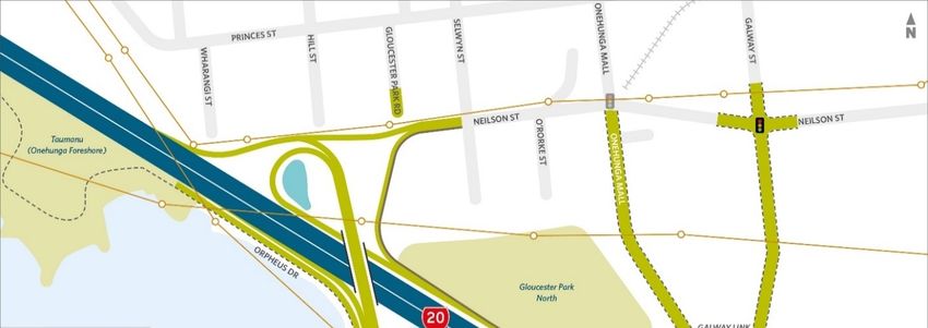
6.3.3 SH20 alignment
Capacity improvements on SH20 are being undertaken in 2016 as part of a wider programme of
improvements along the SH20 corridor. These are described in Section 6.7.1 of this AEE. In addition, the
Project will include the following changes to the existing SH20, which are illustrated in Plan Set 3: Road
Alignment in Volume 2: Drawing Set.
December 2016 | Revision 0 | 45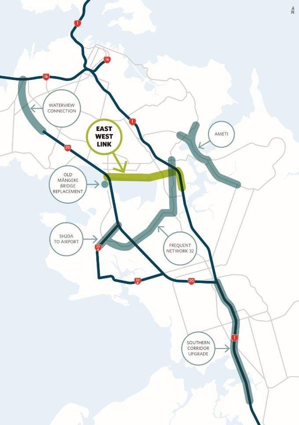
Assessment of Effects on the Environment Report                     Section 6: Description of the Project

·      A bus priority lane leading into a reconfigured off-ramp which directs bus access to a reconfigured
       Galway Street/Onehunga Harbour Road;
·      New on-ramp from the Main Alignment comprising a bridge over SH20 and on-ramp west of the
       existing access from Neilson Street which remains in its current location with lanes merging between
       the two ramps; and
·      Extended bus only on-ramp to SH20.

6.3.4      Local roads

Local roads will be altered and constructed as part of the Project. These are administered by Auckland
Transport. These works are required as part of the Project to provide connectivity to the Project and to
provide improved local road function. The Transport Agency designation for the Project will provide for
these works to occur. The designation will be uplifted from local road areas on completion and local roads
will be transferred to Auckland Transport to operate and maintain. The local roads are described in
Section 6.6 of this AEE.

6.3.5      Walkways, cycleways and shared paths

The Project includes both commuter and recreational cycle paths provided along the Project alignment,
and also in a north-south direction to enhance connectivity to communities in the Onehunga-Penrose
area to the north of the Project. There is no provision for walking and cycling paths on the existing
motorways (SH1 and SH20). There is an existing pedestrian path under the SH20 Manukau Harbour
Bridge which will be retained.

New paths will connect to existing cycle and walking networks, improving connectivity to the wider
Auckland region facilities. Key linkages provided by the Project are illustrated on Plan Set 3: Road
Alignment in Volume 2, and include:
·      Improved linkages in and around the Neilson Street Interchange linking with the New Old Māngere
       Bridge, the new pathways in Taumanu Reserve (Onehunga Foreshore), clearer access into
       Gloucester Park North Reserve and improved facilities on Onehunga Harbour Road and Onehunga
       Mall31;
·      A new Māngere Inlet foreshore with recreational and commuter paths along the alignment;
·      North-south shared path linkages to/from Alfred Street, Captain Springs Road, Waikaraka Park and
       Hugo Johnston Drive, improving access to businesses and the residential communities to the north;
·      Linking the existing Waikaraka shared path through to Sylvia Park Town Centre thereby improving
       the functionality of the existing path which currently ends in an industrial environment in Hugo
       Johnston Drive;
·      A shared pedestrian and cycle path over the Great South Road intersection will provide improved
       east west connections;
·      Wider pedestrian and cycle paths on the replacement bridges across SH1 at Panama Road and at
       Princes Street, improving sight lines and crossing points, and connectivity to residential communities;
       and

31   This connection will maintain and enhance connections from the southern side of the Māngere Inlet, including to
and from the Māngere Bridge township, across the Old Māngere Bridge (and its future replacement structure), and
into the Onehunga Town Centre.

                                                                                   December 2016 | Revision 0 | 46
Assessment of Effects on the Environment Report                   Section 6: Description of the Project

·      A new pedestrian/cycle crossing at Ōtāhuhu Creek parallel to SH1, connecting Mataroa Road (north)
       with Deas Place (south), improving local connectivity between the residential communities east of
       SH1 (Panama Road and Princes Street East).
The Project has been designed to avoid the need for on-road cycling where practicable, with separated
cycling facilities provided beside the Project Main Alignment between SH20 and SH1, and access to the
separated recreational cycle and walkway on the Māngere Inlet coastal edge. Cycle paths will be
designed to the following approximate design specifications (to be confirmed in detailed design):
·      Off-road exclusive cycle paths will be generally be 3m wide;
·      Shared paths will have a minimum width of 3m; and
·      Separated foot/cycle paths will have widths as specified in Auckland Transport Code of Practice
       (ATCOP)32.

The detail of the type of walking and cycling infrastructure, will be developed in the detailed design
process, including both the form and connections. Pedestrian footpaths will generally be provided on
either side of the Project, on all local roads and at signalised intersections (except motorways). Pedestrian
facilities will generally be designed in accordance with the Transport Agency’s Pedestrian Planning and
Design Guide33, the design principles from the Transport Agency’s Urban Design Guideline – Bridging
the Gap34 and the Auckland Transport Code of Practice.

6.3.6      Bus

The Project has been designed to enhance bus connectivity and travel time reliability for buses travelling
from Māngere Town Centre to Onehunga Town Centre via SH20 by removing through traffic from the
local network (Onehunga Mall) onto the EWL. The bus network will also benefit from a reduction of traffic
on Church Street and Neilson Street, resulting from volumes of through traffic moving to the EWL, and
the increased resilience in the network arising from more route options. The reduction of freight traffic
accessing Onehunga Town Centre (including buses) and the traffic accessing the industrial areas to its
east will occur as a result of industrial and freight traffic being encouraged to use the EWL. Key measures
for buses include:
·      Northbound buses: A realigned SH20 Neilson Street off-ramp and new link to Galway Street via the
       new EWL exit. Buses will no longer use Onehunga Harbour Road to access the town centre;
·      Northbound buses: A new link road connecting Galway Street to Onehunga Mall via a roundabout
       and signalised intersection which will be used by buses to access the town centre; and
·      Southbound buses: Existing southbound on-ramps will be realigned. The existing T2 lane (a lane for
       vehicles carrying two or more passengers) at Gloucester Park Road and the SH20 on-ramp will be
       converted to a bus-only lane and will connect directly into the existing bus lanes on SH20.

Galway Street will be primarily used by those travelling west, with Onehunga Mall used by those with
northern destinations, this is self-defining. Onehunga Mall is designed to remain as a 2-lane facility, with
Galway Street as 4-lanes. This will discourage ‘rat-running’ on Onehunga Mall. The role of Onehunga
Mall as a route for pedestrians and cyclists will be via the facilities provided.

During engagement, Auckland Transport advised their preference that buses utilise the existing local
network rather than the new State highway. Therefore no bus priority lanes are proposed on EWL.

32   Auckland Transport, Auckland Transport Code of Practice, March 2014.
33 Transport   Agency, Pedestrian Planning and Design Guide, October 2009.
34 Transport   Agency, Bridging the gap: NZTA urban design guidelines, October 2013.

                                                                                 December 2016 | Revision 0 | 47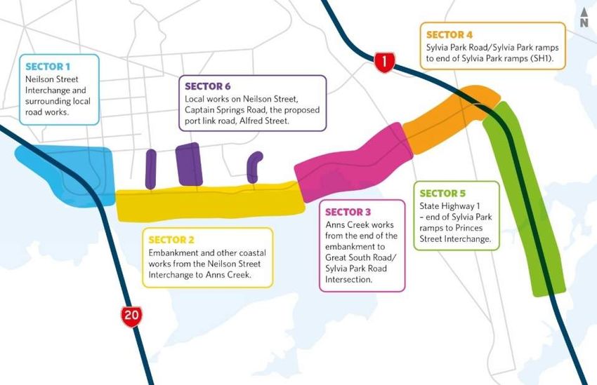
Assessment of Effects on the Environment Report                 Section 6: Description of the Project

6.3.7     Rail

A key feature of the Project is the strategic location in the vicinity of the rail network including Southdown
rail line accessing the KiwiRail land and inland ports. The NIMT rail line is used for freight around the
upper North Island, including from the Port of Tauranga. The Project has been designed to accommodate
existing rail operations and to not preclude the future aspirations of KiwiRail for development of rail
facilities, particularly in the vicinity of the inland ports and Great South Road intersection. Integration of
the EWL with other transport projects (including Auckland Transport multi-modal and mass transit
proposals) are discussed in Section 6.7 of this AEE.

The Project:
·     Where crossing the KiwiRail rail corridor, provides for structures with appropriate clearances over the
      rail network to accommodate ongoing use, electrification and operational constraints;
·     Avoids requirement for land within the designated rail corridor, where there are future aspirations for
      development of rail infrastructure; and
·     Seeks to integrate future rail development with the construction and operation of the Project.

6.4       Design approach

6.4.1     Design Standards and guidelines

The design, including geometric layout, safety features, stormwater, structures, noise barriers and
lighting, has been developed using guidelines that include:
·     The Transport Agency design standards and guidelines; (transport, urban design, pedestrian and
      cycling etc.);
·     The Association of Australian and New Zealand road transport and traffic authorities (AUSTROADS)
      standards;
·     Auckland Council and Auckland Transport standards and guidelines;
·     New Zealand Standards; and
·     Utilities standards.
Safety in Design will be an integral part of the detailed design process. This is a process to ensure that
the right choices about the design are made as early as possible to enhance the safety of the Project, for
those who will construct, operate or maintain it. For example, these choices may relate to methods of
construction, on-going maintenance provisions, or materials used.

6.4.2     Urban and Landscape Design Framework

The Urban and Landscape Design Framework (ULDF) provides guidance on landscape and urban design
principles for the area. The Transport Agency has worked with Mana Whenua, Auckland Council and a
range of other stakeholders to develop an ULDF. The ULDF for the Project is contained in Volume 4:
ULDF.

The overall purpose of the ULDF is to:
·     Demonstrate how the design of the Project supports the Agency’s strategic commitment to high
      quality urban design outcomes;
·     Bring together the delivery of built and natural environment aspirations and outcomes; and
·     Demonstrate alignment between the Transport Agency and other agencies in their planning, transport
      and urban design initiatives for the area. In this regard, the ULDF reflects a wider strategic direction

                                                                               December 2016 | Revision 0 | 48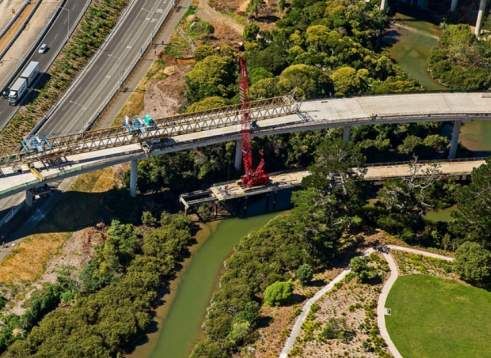
Assessment of Effects on the Environment Report                  Section 6: Description of the Project

      and has a longer term urban and landscape design vision than just what the Project will deliver on its
      own.
CPTED and accessibility principles are fundamental to the development of the ULDF (see for example
Sections 4.1 and 4.1.1-4.1.2 of the ULDF in Volume 4) and will be incorporated into the detailed design.

6.4.3      Travel Times and Travel Time Reliability

A core Project objective is to improve travel times and travel time reliability between the businesses in
the Onehunga-Penrose industrial area. The Project has been designed to improve travel time and
reliability accessing the Onehunga-Penrose area, as well as to have positive travel time/reliability effects
on the wider local road and motorway network.

The Project has been designed to achieve significant improvements in the consistency and reliability of
travel times for trips accessing the strategic network (e.g. SH1 and SH20) from the Onehunga-Penrose
area. With the Project in place, the access times become much more consistent and reliable across the
day, which will in turn allow improved and more flexible journey and logistics planning for businesses in
the area, and result in increased freight efficiency.

The general pattern of changes in daily flow suggests that traffic moves from the adjacent corridor to the
Project, with large reductions in flow and therefore reduced congestion seen on Neilson Street and
Church Street. There is a decrease in flows on other routes, particularly in residential areas.

More than half of the truck movements are expected to be removed from the Neilson Street/Onehunga
Mall and Great South Road/Sylvia Park Road intersections. This reduction allows improved pedestrian
and cycling facilities and amenity, and reduced traffic severance between Onehunga and the Māngere
Inlet, new Taumanu Reserve foreshore and access to the New Old Māngere Bridge35.

The reductions of flows and congestion, particularly on Neilson Street and Great South Road, will improve
accessibility for local businesses onto those arterial roads.

The Project is expected to improve journey times over a much wider area than just Onehunga-Penrose,
including:
·     Between SH20 and Highbrook;
·     Between Onehunga and the Airport;
·     Between Royal Oak and the Airport;
·     Between SH1 and the Airport;
·     Between the inland port and Highbrook; and
·     Between Pakuranga and Onehunga.

The Project has been designed to be complementary to the traffic flows on SH1 and SH20 such that the
extra EWL ramp flows can be accommodated without a detrimental impact on travel along SH1 and SH20.

35   The New Old Māngere Bridge is a proposed replacement bridge for the existing Old Māngere Bridge. Details of
the New Old Māngere Bridge are included in Section 6.7.6.4.

                                                                                December 2016 | Revision 0 | 49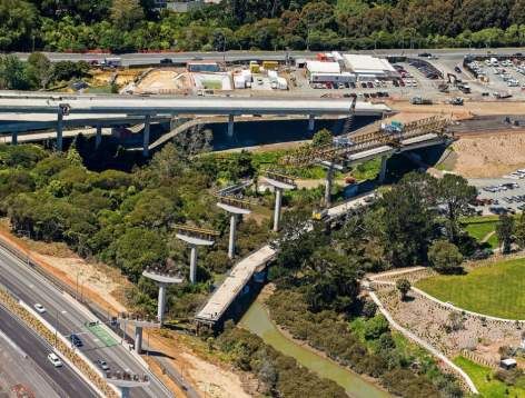
Assessment of Effects on the Environment Report               Section 6: Description of the Project

6.4.4     Interchanges and local road connections

The Project has been designed to provide connectivity to the local network at regular intervals along the
alignment. It is designed to function as an arterial route (not a motorway) which allows for local
connectivity on and off the Main Alignment.

There are two main State highway interchanges – at Neilson Street, Onehunga and at Princes Street,
Ōtāhuhu. The Project also crosses over the existing Mt Wellington Highway, merging into new SH1 lanes
south of the Mt Wellington Interchange.

Direct access to and from the Main Alignment will be provided via controlled intersections accessing onto
and off roads designed to local road standard, extending Galway Street and Captain Springs Road
southwards, a new cul-de-sac accessing the inland ports land, at Hugh Johnston Drive and at Great
South Road.

The intersections will generally be signalised, depending on the design requirements and space
constraints. The EWL/Great South Road/Sylvia Park Road intersection will be maintained with traffic able
to pass under the new viaduct. Access for all properties with existing access onto Great South Road will
be maintained. However, some entrance/exits will be changed to accommodate improved safe ingress
and egress onto the Great South Road intersection. The Sylvia Park Road and Pacific Rise intersection
will be maintained with traffic able to pass under the new elevated south facing ramps onto SH1. Access
will be maintained for all properties on the northern side of Sylvia Park Road, however some
rationalisation of existing accessways and accommodation works will be required as not all movements
will be provided for. The changes will limit the number of right turns in and out of properties along Sylvia
Park Road.

6.4.5     Design speed/posted speed

The design speed across the Project varies depending on the function of the roads. Whilst State highways
are often associated with motorway or open road speed, there are other State highways with lower design
speeds (generally the design speed is 10km/h higher than the posted speed). The general philosophy of
design speeds are as follows:
·     SH1 and SH20 are designed at higher speed to match the speed limits within the existing State
      highway network with a normal posted speed of 100km/h;
·     The Neilson Street Interchange is designed with a lower speed to accommodate curved ramp
      connections and connectivity from local roads;
·     East of the ports link road through to where the ramps tie into SH1, the Main Alignment has a design
      speed of 80km/h. A shared path is located on the southern side of the Main Alignment between the
      ports link road and Great South Road;
·     The Main Alignment along the Māngere Inlet foreshore will be an arterial catering for heavy vehicles
      turning in and out of signalised intersections (with a design speed of 70km/h). There will be a
      shoulders and pedestrian and cycle paths on each side of the carriageway. It will be designed to have
      an urban arterial appearance;
·     The ramp connections to and from SH1 will be designed for a speed in between local road and
      motorway, accommodating the change in environment between motorway and urban arterial; and
·     Local roads, Galway Street, Captain Springs Road, the port link road, Great South Road and Hugo
      Johnston Drive have a design speed of 50/60km/h depending on new and existing constraints.

6.4.6     Traffic Services

Traffic services includes features such as:
·     permanent road signs and gantries, including variable message signs;

                                                                             December 2016 | Revision 0 | 50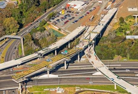
Assessment of Effects on the Environment Report                   Section 6: Description of the Project

·     lighting; and
·     required safety features including barriers.

The traffic services that are to be in place when the Project initially opens to traffic will be considered and
finalised during the detailed design phase and will be designed in accordance with the relevant standards
at the time the Project is constructed. Throughout the life of the Project, it is anticipated that traffic services
will be renewed and upgraded as required, to ensure the continued safe and efficient operation of the
State highway. This would be done as part of the normal operation and maintenance.

The services will include:

    Signage       Design of all road signs and markings will be in accordance with the appropriate versions
                  at the time of the Manual of Traffic Signs and Markings (MOTSAM), and the Land
                  Transport Rule: Traffic Control Devices. Signage, including overhead gantries, will be
                  required to be installed at locations along the route to meet these standards.

    Lighting      Provision has been made for lighting along the full alignment. In some areas, lighting
                  may be minimised to reduce the impact on ecologically sensitive areas.

                  All operational lighting for the Project will be designed to comply with AS/NZS 1158:2005
                  Lighting for Roads and Public Spaces (Standards New Zealand and Standards
                  Australia, 2005). Specific requirements:
                  ·   all SH1 and SH20 ramp lighting will have lighting levels appropriate for roads with
                      no property accesses and carrying large volumes of traffic.
                  ·   sections of the road which do not receive direct natural light due an obstruction will
                      be lit 24 hours per day (e.g. under bridges).
                  ·   sections of the road which do not receive direct illumination from the pole mounted
                      road lighting, will be lit via alternative methods (e.g. mounted on a structure), as is
                      provided for in the trench section of the new State highway at Onehunga wharf.
                  ·   shared paths, where separated from roads by a significant distance, will be lit using
                      ground mounted lights unless there is adequate light spill from the adjacent roadway
                      lighting.

    Safety        Safety features will be appropriate to the motorway or arterial road environment in which
    features      they are located and will include medians, shoulders and barriers.

6.4.7     Network Utilities

The location of the Project at the narrowest point of the North Island means there are numerous
infrastructure networks converging in the area, making for a complex built environment. The Project will
require the relocation and works in the vicinity of major utilities – including regionally and nationally
significant infrastructure. Major infrastructure that will require relocation and/or protection as part of the
Project is discussed in detail in Section 12.5: Network Utilities of this AEE. In summary major
infrastructure includes:
·     Transpower: relocation of towers and lines in some locations (both 110 and 220kV lines);
·     First Gas: relocation of a high pressure gas main; and
·     Watercare: crossing over the Hunua No. 4 Watermain and other major water and wastewater
      infrastructure.

With the exception of the Transpower relocations (which are covered by specific legislative provisions),
works required for network utility relocations are within the scope of the proposed works for which
consents are being sought.

                                                                                  December 2016 | Revision 0 | 51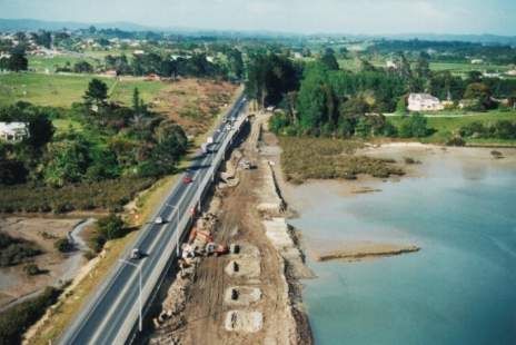
Assessment of Effects on the Environment Report                    Section 6: Description of the Project

6.4.8   Structures approach

Structures comprise part of the two major interchanges, as well as bridging over areas that include
elements of the existing built environment such as the rail corridor, and the natural environment,
ecological and geological features.

The bridge structures required as part of the Project are summarised in Table 6-1 below and the location
of the major structures are indicated in Figure 6-1. Further detail on the location and form of the bridges
is contained within the drawings in Volume 2: Drawing Set.

Figure 6-1: Structures along the alignment

Table 6-1: Bridge structures

 Chainage      Location and Purpose                                                  Description
 200           As part of the new Neilson Street Interchange design, a new           Two traffic lanes – one each
               bridge over the existing SH20 alignment is required. Its purpose      way, on a skew across SH20.
               is:                                                                   No pedestrian or cycle access
                                                                                     will be provided.
               ·   to provide access onto EWL for traffic coming off SH20 at the
                   Neilson Street southbound off-ramp; and
               ·   for traffic coming from EWL and Onehunga getting onto SH20
                   heading southbound.

                                                                                   December 2016 | Revision 0 | 52
Assessment of Effects on the Environment Report Section 6: Description of the Project
Chainage Location and Purpose Description
720 Local road bridge, pedestrian and cycle access over the EWL Two traffic lanes with
from Onehunga Harbour Road providing access to the footpaths either side.
Onehunga Wharf (25m width). This bridge spans over the new
EWL alignment which is constructed below current ground level
in a trench in order to improve accessibility and connectivity to
the port. The structure provides for the future bridging of up to
50m over the State highway in this section (if appropriate to
enable integration with the future development of the Onehunga
wharf).
850 As part of the construction of a new configuration of Onehunga Replacement structures for
Harbour Road and extension of Galway Street, a new pedestrians and cyclists.
replacement pedestrian bridge, crossing over Onehunga Harbour
Road and the Project is required, providing access to the
foreshore walkway and Māngere Bridge.
850-3350 A bridged boardwalk is proposed along the Māngere Inlet Pedestrian / shared paths.
foreshore as part of the new recreational shared path. This will
tie into paths constructed as part of the new foreshore
landscaped edge.
3620 - 4420 New viaduct crossing the CMA and the Southdown rail spur, Four traffic lanes with a raised
between the Māngere Inlet foreshore and landing on new median, narrow shoulders,
embankment at the end of Hugo Johnston Drive. Viaduct has and a shared path (pedestrian
been designed to cross over marine ecological areas and and cycle) on the southern
geological features. “Pier exclusion” areas are specified based side.
on these sensitive environmental features.
4470-4980 New viaduct crossing the main trunk rail line, geological and Four traffic lanes with a raised
ecological areas in Anns Creek, to tie in with the new intersection median, narrow shoulders,
at Great South Road. and a shared path (pedestrian
and cycle) on the southern
side.
4980-5700 Viaduct continuing from Anns Creek, tying in with the new grade Grade separated two traffic
separated Great South Road intersection to maintain existing lanes – one each way over
connections and provide for east west movements. Great South Road and
connections from EWL to
Great South and Sylvia Park
Roads. Separate pedestrian
and facilities provided as a
shared path over Great South
Road.
5730-6500 New bridge from Sylvia Park Road linking onto SH1 southbound, Two lanes reducing to one at
merging into an additional (new) lane on the eastern side of SH1. SH1.
5730-6280 New bridge from Mt Wellington Highway SH1 northbound One lane.
providing an off-ramp to Sylvia Park Road and EWL.
7150 Replacing the existing Panama Road overbridge over SH1 with a Two traffic lanes, flush
new, longer bridge to accommodate additional lanes on SH1 median, shared paths either
(one lane either side of SH1). The new bridge will also side.
accommodate wider footpaths and provide for safer cycle
access.
8000 The existing triple box culvert carrying SH1 over Ōtāhuhu Creek New SH1 bridge – eight lanes
will be replaced with a new bridge. The new bridge will plus shoulders in each
accommodate additional lanes (on either side of the existing direction.
SH1).
December 2016 | Revision 0 | 53Assessment of Effects on the Environment Report Section 6: Description of the Project
Chainage Location and Purpose Description
8000 To carry out the culvert replacement on SH1 a new additional Local access bridge.
bridge structure will be constructed to divert traffic onto. This will
be constructed on the eastern side of the existing SH1
alignment. This bridge will remain in place permanently and will
enable local pedestrian and cycle connectivity across Ōtāhuhu
Creek.
8600 In order to widen SH1 on either side, the Princes Street Four traffic lanes with a flush
Interchange overbridge will be replaced with a longer structure, median, shared paths on
and a complete reconfiguration of the Princes Street Interchange either side of the new
is proposed. This includes a new on-ramp for southbound traffic overbridge.
(from Frank Grey Place) which will pass underneath the new
overbridge. The new bridge will accommodate additional lanes,
better providing for local through traffic separated from motorway
traffic, and more clearly defined walking and cycling routes.
6.5 Other works
6.5.1 Open Space / Recreation
The Project involves the creation of new public open space on the coastal edge. This will comprise open
areas and walkways, pebble banks and headlands. This is shown in the Volume 2: Drawing Set.
In addition to the pedestrian and cycle connections, the following recreation linkages are incorporated
within or enabled by the Project:
· Provision of a 4.0m recreation path on the southern side of the new State highway, between Old
Māngere Bridge (or its planned replacement) and its connection to the existing Manukau Foreshore
Walkway (also known as the Waikaraka Walkway) at the inland Port, with separation between the
walkway and the new arterial road; and
· Opportunity for provision of connection between the Project shared path and recreation walkway and
the future ‘greenways’ link to the eastern edge of the Māngere Inlet (parallel to rail).
6.5.2 Coastal works
The Project requires works on the coastal edge and within the CMA in the Māngere Inlet and in Ōtāhuhu
Creek. Table 6-2 describes the approximate areas of coastal works in the Māngere Inlet and Table 6-3
describes the approximate areas of coastal works in Ōtāhuhu Creek.
December 2016 | Revision 0 | 54Assessment of Effects on the Environment Report Section 6: Description of the Project
Table 6-2: Approximate Areas of Reclamation, Permanent and Temporary Occupation (Sector 2)
Reclamation Permanent Temporary
(rounded) Occupation Occupation (for
(rounded) construction)
Road Embankment 5.6 ha 0.9 ha
Landscape features and wetlands 12.7 ha 4.4 ha 11.1 ha
Boardwalk - 0.7 ha
Anns Creek bridges - 0.8 ha 1.1 ha
Anns Creek bridge piles - 0.01 ha 0.02 ha
Total 18.4 ha 6.68 ha 12.85 ha
The proposed construction methodology also includes the potential excavation of marine sediments to
use in construction of the proposed road embankment and foreshore bund. This is described in
Section 7.0: Construction of the Project of this AEE.
Table 6-3: Approximate Areas of Reclamation, Permanent and Temporary Occupation (Sector 5)
Declamation Permanent Temporary
Occupation Occupation (for
construction)
Ōtāhuhu Bridge 0.5 ha 0.12 ha 0.16 ha
6.5.3 Acoustic barriers
The Project passes through a variety of different noise environments some which have low ambient noise
levels and others which have reasonably high ambient noise levels. Different levels of noise mitigation
are required throughout the Project area.
The guiding approach for the acoustic design is to address the adverse effects of road-traffic noise on
people through adopting the best practicable noise mitigation options to keep noise at a reasonable level
at sensitive receivers. The design solutions to address the increased noise levels can be, but are not
limited to:
· New noise barrier construction at the boundary of the State highway corridor or adjacent to traffic
lanes;
· Design and incorporation of low noise roadway surfacing;
· Increased heights of roadside barriers; and
· Modifying of existing buildings at sensitive locations to mitigate noise issues.
All noise attenuation design will be carried out in accordance with NZS 6806:2010 – Acoustics – Road
Traffic Noise – New and Altered Roads.
Where required, acoustic barrier height varies depending on the modelled requirements and topography.
Barriers will be constructed from a material that performs to meet the appropriate acoustic performance
requirements. Options that can meet the required standard include a range of concrete or timber products,
which will also need to meet the Transport Agency’s durability considerations from a maintenance and
whole of life cost perspective. The recommended options for traffic noise mitigation are set out in further
detail in Section 12.11: Noise and Vibration of this AEE.
December 2016 | Revision 0 | 55Assessment of Effects on the Environment Report Section 6: Description of the Project
6.5.4 Stormwater
In developing the stormwater treatment concept for the Project, the opportunity to incorporate treatment
of a wider urban catchment (other than just the road surfaces) was identified. The integrated design
development incorporates treatment for over 600ha additional to the requirements for the road in Sector 2
of the Project.
The approach for stormwater design has been to use guiding principles, identified below, and to develop
the solution for the whole alignment from those principles. The approach has been to seek opportunities
for “natural” treatment of stormwater as a preference where there is space available, and to use
proprietary devices as an alternative where less space is available.
For the treatment of stormwater from the road alignment (both the new road and sections of existing
SH20 and SH1), the design concept is to use “best practicable option” that aligns with Auckland Council
guidance documents (including the AUP (OP) and Auckland Council Technical Publications) with respect
to discharges in relation to flow rates, volumes and quality.
The stormwater concept – for both quality and quantity – has been developed to a preliminary level, and
will be further developed at subsequent design stages in consultation with Auckland Council. These
designs will be aligned with the outcomes described in this AEE.
6.5.4.1 Stormwater – quantity
The performance of stormwater systems is a key design objective for safe operation and use of the road
network both on local roads and the State highway network. Specifications include managing stormwater
flows on main carriageways to disperse quickly away from traffic lanes. This includes designed overland
flow paths that cater for a 1% annual exceedance probability36 rainfall event, or where no overland flow
path is available, the capacity of the primary system is designed to cater for the 1% annual exceedance
probability rainfall event.
6.5.4.2 Stormwater – quality
The approach for stormwater quality has been to take a “best practicable37 option” approach having
regard to:
· Mana Whenua’s views of appropriate outcomes, including a preference for natural methods that
involve water passing through or over land;
· Guidance set out in Auckland Council TP10 (Stormwater Management Devices) and testing against
other guides;
· Wetlands preferred and constructed devices (such as cartridges or storm filters) secondary;
· Ease of maintenance and whole of life considerations including safety for access;
36 Annual Exceedance Probability (AEP) event indicates the significance of the potential storm event and percentage
chance of it occurring in any given year. It is used as a design criteria to inform sizing (such as pipework, ponds and
treatment devices) for stormwater infrastructure.
37From RMA Section 2 “Best practicable option, in relation to a discharge of a contaminant or an emission of noise,
means the best method for preventing or minimising the adverse effects on the environment having regard, among
other things, to – (a) the nature of the discharge or emission and the sensitivity of the receiving environment to
adverse effects; (b) the financial implications, and the effects on the environment, of that option when compared to
other option; and (c) the current state of technical knowledge and the likelihood that the option can be successfully
applied.”
December 2016 | Revision 0 | 56Assessment of Effects on the Environment Report Section 6: Description of the Project
· Use of innovation to reduce treatment area footprint having regard to the constrained urban
environment and limited corridor space;
· Opportunity to incorporate stormwater treatment within a constructed coastal edge reclamation; and
· Where practicable, the use of temporary (construction) ponds to be converted into permanent
wetlands.
Practical design considerations and outcomes need to take into account:
· The existing stormwater collection and disposal network that includes older pipework discharging to
natural watercourses and the CMA at a low level, meaning discharge is often below the level of the
tide;
· Climate change and sea level change effects;
· Ability to accommodate a 10% annual exceedance probability rainfall event (that is, a one in 10 year
event), with pipework designed to achieve self-cleaning velocities, minimising build-up of debris in
pipes;
· Potential for water to back up in the pipes during rainfall events, due to the low level of discharge and
the flat gradient of pipe work;
· Permanent erosion protection measures to protect against localised scour at outfall locations,
including new structures within the CMA and existing outfall structures; and
· Placing stormwater manholes outside live traffic lanes and sealed areas to accommodate a safe
environment for maintenance activities.
The following provides a summary of the approach:
Overall concept The stormwater treatment wetland areas consist of two key components; freshwater
wetland areas and biofiltration areas (raingardens). The use of biofiltration areas in addition
to wetlands, enables the treatment of stormwater in a greater number of rainfall events in a
smaller surface area.
Wetlands Wetlands will be shallow (water depths 100-300mm), extensively vegetated water bodies
that use enhanced sedimentation, fine filtration and pollutant processes to remove
pollutants from stormwater. Stormwater will be discharged from the collection network into
a forebay where coarse sediment will settle out. Flows will then enter the main shallow
heavily vegetated area to remove fine particulates and soluble pollutants. Wetlands will
treat base flows and small storm events and discharge treated flows through outfalls in, for
the most part, the CMA.
Bio-filtration/ A concept for using biofiltration systems (an alternative filtration system using natural
rain gardens plants) has been developed for EWL because they are less space-hungry than wetlands,
and emulate natural treatment systems. Space is an important consideration in a
constrained urban environment. These systems are vegetated soil biofiltration systems that
provide efficient sediment and nutrient removal from stormwater. The biofiltration system
remains dry under normal conditions and minor storm events and will treat stormwater
flows during moderate rainfall events.
Proprietary In some instances, proprietary devices will be used. This will be where there is limited
devices space so an underground solution (that limits land requirements) is preferred.
Outfalls Treated water will be discharged from either the wetland and biofiltration systems, or the
proprietary devices (whichever is used), to constructed outfall structures in the CMA –
some with tidal control included, natural watercourses or the piped network. These are
designed to function effectively with predicted sea level changes as discussed in Volume 3:
Technical Report 12 - Stormwater Assessment.
6.5.4.3 Stormwater treatment wetland
Stormwater from the local road network, and the wider Onehunga-Penrose urban catchment is currently
untreated and discharges directly to Miami Stream, and via the stormwater network to the CMA through
December 2016 | Revision 0 | 57Assessment of Effects on the Environment Report Section 6: Description of the Project
eleven discharge locations along the foreshore. Working in collaboration with Auckland Council, the
Transport Agency has undertaken to achieve stormwater quality treatment for both the new road
carriageway and part of the wider urban catchment within a new constructed coastal edge.
This involves the construction of new wetlands and biofiltration areas to capture and treat stormwater
from both the road alignment and inland Onehunga-Penrose catchment. The wetlands will contain a
range of vegetation types suitable for these environments and intended to visually appear similar to
estuarine marshland, blending in with the landscape treatment. The current concept includes new outfalls
with flap gates (to prevent tidal inundation) occupying the CMA which will require access for periodic
maintenance.
As the majority of the Onehunga-Penrose urban catchment is outside of the future State highway corridor,
it is intended that Auckland Council will become the future asset owner of a large component of the
stormwater system. The final details of the catchment areas to be treated and the treatment standards to
be achieved, will be developed in the detailed design phase in close consultation with Auckland Council
as future asset owner. The final arrangements will also be subject in some areas to the ability to secure
private land outside of the proposed designation area (e.g. at Miami Stream).
6.5.4.4 Drainage and stormwater treatment
The Project will involve new stormwater quality treatment with extended detention and flood attenuation
for all the new surfaces and modified existing surfaces. The stormwater treatment includes:
· A new wetland on the north-western side of the interchange adjacent to the end of Hill Street within
the proposed new loop on-ramp to SH20 from the Main Alignment and an enlarged wetland on the
south-western side of the interchange adjacent to the off-ramp from SH20 onto the Main Alignment;
· Upgrading the existing wetland within Gloucester Reserve South;
· A number of existing outfalls will be retained, along with the existing stormwater management area
in the Anns Creek area bounded by the western extent of the rail corridor, and which overlaps with
existing ecological areas. The viaducts over the Great South Road intersection will discharge treated
stormwater to Anns Creek;
· One new stormwater treatment wetland is located at the end of Hugo Johnston Drive capturing and
treating stormwater from the new viaduct west of Great South Road and discharging to existing
pipework on the edge of Southdown Reserve;
· Surface water treatment from all road surfaces in proprietary devices where wetlands are not an
option, including on the new viaduct structures;
· Installation of new treatment for all existing and modified SH1 surfaces – a significant improvement
to the current situation where sections of SH1 are currently untreated. This involves a complex
network of underground infrastructure and the use of proprietary devices to provide treatment; and
· Proprietary devices will be installed on SH1 which will treat all stormwater from the Transport
Agency’s existing and new road surfaces. An existing stormwater wetland at Princes Street
Interchange will be expanded.
All outfalls and discharge points for stormwater are shown in indicative locations in Plan Set 9: Stormwater
in Volume 2.
6.5.5 Climate change
For coastal infrastructure, sea level rise is required to be considered over a 100 year period. The Ministry
for the Environment publication “Preparing for coastal change: A guide for local government in New
Zealand” (dated 2009) and the AUP (OP) recommend a sea level rise of 1.0m for infrastructure projects
be provided for over a 100 year period. The Transport Agency’s Coastal Effects Assessment Guide has
also been considered for the Project. The Māngere Inlet alignment has been designed to accommodate
1.0m sea level rise and includes a “wave run-up allowance” suitable for the low energy environment (of
December 2016 | Revision 0 | 58Assessment of Effects on the Environment Report Section 6: Description of the Project
0.50m). This means the combined effect is to establish the outer edge of the road alignment at a minimum
of 4.5m RL.
6.5.6 Contaminated land and geotechnical consideration
The Main Alignment along the Māngere foreshore and some of the local roads will be constructed over
historic landfills. In these areas specific design is proposed in order to limit post construction settlement
of the road alignment. This will involve specific design on a case-by-case basis to achieve a firm
foundation to build from, and to minimise post-construction settlement. In some locations there are
specific design requirements to accommodate the presence of contaminated materials and these are
discussed in the sector descriptions below.
Key construction considerations for works in contaminated land are discussed in Section 7.0:
Construction of the Project of this AEE. Key design considerations include the use of piled and reinforced
road alignment, even where constructed at current ground level to minimise settlement and potential
impact on drainage piped networks.
6.6 Physical description – Project sectors
To assist with an understanding of the proposed works and the potential effects of these works, the
alignment has been divided into six sectors as shown on Figure 6-2.
Figure 6-2: Project sectors
Note: In this section, Sector 6 is described in conjunction with Sector 2 – as it relates to the local roads
that provide connectivity to EWL in this location.
Further detail is contained in Plan Set 1: General Drawings in Volume 2: Drawing Set. The Project will be
in general accordance with these plans. Table 6-2 lists the sectors described in the remainder of this
December 2016 | Revision 0 | 59Assessment of Effects on the Environment Report Section 6: Description of the Project
section along with their drawing page references from Plan Set 1: General Drawings in Volume 2: Drawing
Set.
Table 6-4: General Arrangement design drawings for each Sector
Sector Drawing in Plan Set 1
Sector 1 – Neilson Street Interchange G-101
Sector 2 – Māngere Inlet G-102 to 103
Sector 3 – Anns Creek G-103 to 104
Sector 4 – Sylvia Park Road and Mt Wellington ramps G-104 to 105 Rev 1
Sector 5 – SH1 widening and Princes Street G-106
Sector 6 – Local connections G102 to 103
December 2016 | Revision 0 | 60Assessment of Effects on the Environment Report Section 6: Description of the Project
6.6.1 Sector 1 – Neilson Street Interchange
6.6.1.1 General Description
The Neilson Street Interchange has been designed with a main alignment route around the southern part
of the interchange connecting to SH20 to and from EWL and the new Galway Street extension to connect
local traffic into the local community and to and from SH20. The interchange provides for the following:
· Additional capacity at the SH20 interchange.
· Separation of local (Onehunga) and industrial/business traffic through this interchange; this includes
reducing traffic (especially trucks) in the area between Onehunga Town Centre and the
foreshore/New Old Māngere Bridge and Galway Street because the traffic accessing EWL and SH20
will predominantly use the new Galway Street extension instead of the existing Onehunga Harbour
Road.
· Reduction of the significant current traffic congestion for buses accessing Onehunga Town Centre
via SH20 – the frequent bus service from Māngere to Onehunga will be able to use the Galway
Street/Onehunga Harbour Road connection.
· A significant reduction in traffic on Onehunga Harbour Road/Onehunga Mall enabling enhanced
pedestrian and cycle facilities to be provided between the Onehunga Wharf and Town Centre.
· Free-flowing connections between EWL and SH20 with a T2 lane giving priority to buses, heavy
vehicles and high occupancy vehicles.
Figure 6-3: Sector 1 diagram
December 2016 | Revision 0 | 61Assessment of Effects on the Environment Report Section 6: Description of the Project
6.6.1.2 Local roads
The Project will involve modification to local roads:
· Closing Gloucester Park Road north access onto Neilson Street to allow for the new SH20 access
configuration;
· Improving local connectivity from Gloucester Park Road south to Neilson Street with a reconfigured
connection;
· The existing Onehunga Harbour Road will be reconfigured with the wharf access local road crossing
over the EWL Main Alignment to connect to Orpheus Drive;
· Parking outside The Landing and apartments on Onehunga Harbour Road will be reconfigured and
alternative parking provided in areas on Onehunga Harbour Road for the equivalent number of car
parks. Other areas currently used for parking for recreation activities (e.g. the informal parking under
Manukau Harbour Crossing on Onehunga Harbour Road) will be removed and alternative locations
for on-street parking for the recreation will be provided (e.g. at Hugo Johnston Drive);
· Onehunga Harbour Road/Orpheus Drive will include a new shared path to link to the existing
pedestrian/cycle way on Orpheus Drive (to Taumanu Reserve); and
· Galway Street will be extended south with a four-lane configuration providing at grade signalised
intersection onto the Main Alignment for local connectivity and with cross-connection to Onehunga
Harbour Road and Onehunga Mall.
6.6.1.3 Onehunga Wharf connectivity
A new land-bridge will provide access along Onehunga Harbour Road and between Onehunga Harbour
Road and the Onehunga Wharf. This has been developed in consultation with Panuku Development
Auckland (an Auckland Council Controlled Organisation (CCO) hereafter referred to as Panuku) to
integrate with the “Transform Onehunga” strategy for the future of the Port and wider surrounding area.
While the Project provides for construction of a 20m wide bridge (with local road and shared paths), there
is provision for the bridge structure of the trench to be up to 50m (approximate) wide/long. The current
design provides for local connection along Onehunga Harbour Road to/from Orpheus Drive, while the
extended bridging provides an opportunity for future land use integration between 2-6 Onehunga Harbour
Road and the Onehunga Wharf development site.
6.6.1.4 Pedestrian, cycleway and shared path
The Project includes new and modified pedestrian and cycle connections at Neilson Street as follows:
· Shared path from the New Old Māngere Bridge connecting with the existing walking and cycling
facilities at the Taumanu-Onehunga Foreshore via Onehunga Harbour Road, the Wharf and Orpheus
Drive;
· Shared path between the Onehunga Wharf land-bridge and the intersection of Onehunga Mall and
Neilson Street. The shared path will pass underneath SH20 and along the western side of Onehunga
Harbour Road and Onehunga Mall;
· Footpath on the northern side of the new Galway Link and both sides of Galway Street (between
Neilson Street and Galway Link);
· The existing Onehunga Harbour Road pedestrian overbridge will be replaced to go over the EWL
and the existing underpass under the SH20 bridge to the cul-de-sac at Onehunga Mall will remain;
and
· Commuter cycle path, footpath, and recreation connections on the southern side of the Main
Alignment, providing contained public access to and along the CMA through this area.
December 2016 | Revision 0 | 62Assessment of Effects on the Environment Report Section 6: Description of the Project
6.6.1.5 Key bridges and structures
In Sector 1, the Project includes these major bridges and structures:
· A new bridge over the existing SH20 alignment to provide access onto EWL for traffic coming off
SH20 at the Neilson Street southbound off-ramp, and for traffic coming from the Main Alignment and
Onehunga getting onto SH20 heading southbound;
· The new bridge over SH20 involves construction of retaining wall abutments of some 8-10m in height
facing onto Onehunga Harbour Road / Orpheus Drive;
· Local road crossing over the new Main Alignment (with the EWL constructed in a trench) to improve
accessibility and connectivity to Onehunga Wharf (described further above); and
· A new replacement pedestrian bridge, crossing over Onehunga Harbour Road and the Main
Alignment providing access to the foreshore walkway and the New and Old Māngere Bridges. The
foreshore walkway is on structure in part.
6.6.1.6 Acoustic barrier
The Project involves the construction of new noise barriers on one side of SH20 adjacent to residential
terrace housing located on Onehunga Harbour Road. The location of the acoustic barriers are shown on
the drawings in Plan Set 3: Road Alignment in Volume 2: Drawing Set.
6.6.1.7 Closed landfills
There are areas of fill that the Project will affect in Sector 1 at Gloucester Park Reserve and Galway
Street. The former municipal landfills such as Galway Street and the others described in Sector 2 below
are recognised as distinct from the areas of “uncontrolled fill” such as the reclamation within Gloucester
Reserve.
There are limited works required that will disturb soils in the filled parts of Gloucester Reserve. These
include:
· Widening of SH20 southbound; and
· Realignment of the SH20 northbound off-ramp.
At the Galway Street landfill (partly located in Sector 1), the Main Alignment is located on existing
reclamation, and the local road connection will encroach into the landfill footprint. The description for
works on this landfill is described below under Sector 2.
6.6.2 Sector 2 – Māngere Inlet and Sector 6 - Local Road Connections
6.6.2.1 Sector 2 – General description
The Māngere Inlet foreshore alignment includes:
· Four lane arterial road constructed on ‘land’ (partly on existing landfill and partly on an earth and
mudcrete embankment) with shoulders and a mixture of commuter cycling path on the south side and
shared path along the length;
· The alignment straddles the CMA edge and land to varying degrees along the northern shore of the
Māngere Inlet;
· Removal of the existing Auckland Council foreshore amenity strip and Manukau Foreshore Walkway
in part;
· A new landscaped foreshore and recreational space comprising three reclaimed headlands, pebble
banks, recreational paths and bridged coastal walkways, and incorporating stormwater and leachate
treatment wetlands;
December 2016 | Revision 0 | 63You can also read