FISH CREEK WATERSHED PLAN - Town of Gibraltar
←
→
Page content transcription
If your browser does not render page correctly, please read the page content below
Vision for Fish Creek:
                                                             A Healthy Stream Ecosystem that Supports
                                                            the Environmental and Economic Interests of
                                                                          the Community

                           FISH CREEK
        WATERSHED PLAN                                           Prepared for the Town of Gibraltar by Nancy Turyk
Town of Gibraltar, Door County, Wisconsin, September 2017        Center for Watershed Science and Education
                                                                 University of Wisconsin-Stevens Point
Protecting and Improving Fish Creek, Town of Gibraltar, Door County, Wisconsin                                             2017

  Many people contributed to the development of this plan. We acknowledge
  the following people and agencies for their leadership and assistance.

         Linda Merline for written and photographic contributions in this plan
         and coordination of the grant and planning processes.
         Data collection by the Fish Creek Watershed Study Volunteers.
         Funding and support provided though the Town of Gibraltar and
         Wisconsin Dept. of Natural Resources.
         Donated expertise by Dr. Paul McGinley.

                                         The Fish Creek Watershed Plan was adopted by the Town of Gibraltar on:

                              The Fish Creek Watershed Plan was approved by the Wisconsin Dept. of Natural Resources on:

         N. Turyk, University of Wisconsin-Stevens Point, Center for Watershed Science and Education, September 2017
                                                                                                                                  1
Protecting and Improving Fish Creek, Town of Gibraltar, Door County, Wisconsin                                                                                                                   2017

  Contents                                                                                                                  Appendix G: Preliminary Hydrologic Modeling and Analysis of Fish Creek,
                                                                                                                            Door County, Wisconsin ............................................................................. 6
  Plan Development .......................................................................................... 3
         Whose plan is this? ................................................................................. 3
  Goals ............................................................................................................... 5
  The Fish Creek Watershed............................................................................ 16
     Geology dictates groundwater behavior .................................................. 16
     Land Use and Water in the Fish Creek Watershed................................... 16
         Stream Temperatures........................................................................... 18
         Water Flow and Water Quality............................................................. 19
         Potential Changes to Fish Creek from Development ........................... 21
         Planning for Increases in Hard Surfaces ............................................... 23
     In Stream Habitat and the Fish Community ............................................. 28
         Aquatic Insects and Stream Habitat ..................................................... 28
         Fish Barriers and Habitat Issues ........................................................... 29
     The Bad: Invasive Species ......................................................................... 32
  History of Fish Creek ..................................................................................... 34
  References .................................................................................................... 35
  APPENDICES .................................................................................................. 36
     Appendix A: Watershed Communities and Management ......................... 1
     Appendix B: Sensitive habitat types and plant species in the Fish Creek
     Watershed .................................................................................................. 6
     Appendix C: Sensitive animal species in the Fish Creek Watershed. ......... 7
     Appendix D. Land use categories in the Fish Creek subwatersheds. ......... 3
     Appendix E: Water quality sampling sites in Fish Creek watershed. ......... 4
     Appendix F: Summary of water quality results by site. 1999-2015. ......... 5
         N. Turyk, University of Wisconsin-Stevens Point, Center for Watershed Science and Education, September 2017
                                                                                                                                                                                                                                2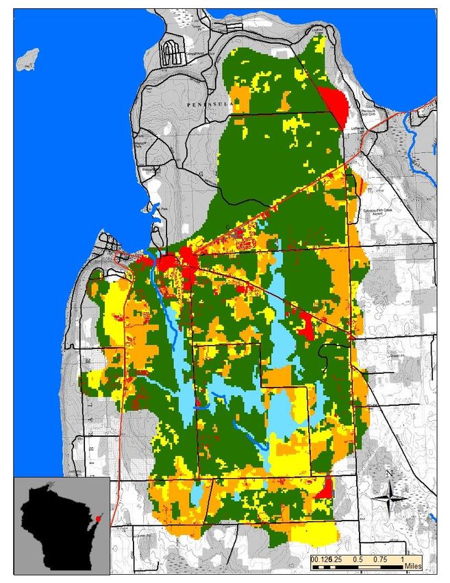
Protecting and Improving Fish Creek, Town of Gibraltar, Door County, Wisconsin                                                       2017

                                                                                old Gibraltar Town Hall in Fish Creek.

                 Vision for Fish Creek:                                         The goals and steps identified in this plan are based on the best available
                                                                                science and consider the opinions and needs of the community while
       A Healthy Stream Ecosystem that Supports                                 remaining consistent with local, state, and federal guidance and rules. Flow
       the Environmental and Economic Interests                                 data was non-existent; therefore, the flow model and recommendations
                                                                                could be refined by collecting data and updating the model in the future.
                  of the Community                                              Whose plan is this?
                                                                                Many partners are needed for the care and restoration of Fish Creek. The
                                                                                lead partners have been identified in the steps laid out in this plan;
  Fish Creek is the namesake for the local community and it provides the        however, many additional individuals or groups may participate in the
  backdrop for many rich memories and stories. The creek is appreciated by      implementation of the actions needed to accomplish the shared vision for
  residents and visitors, with many having spent countless hours near and in    Fish Creek. Updating each other annually about plans and accomplishments
  Fish Creek, enjoying its cooling waters, wildlife, and natural beauty.        will help to achieve the goals for Fish Creek and keep this plan fresh. The
                                                                                Town of Gibraltar Planning Commission will be the keeper of this plan.
  Fish Creek Plan Development
  The development of this plan was initiated by the Fish Creek Watershed
  Study Volunteer Leaders and developed by the Town of Gibraltar Planning
  Commission and Town Board, with the intent of compiling and interpreting                                  Community Opinions
  existing data to inform discussions about the protection and restoration of
  Fish Creek.
  Community members gathered at two public discussions to learn about the
  creek and identify attributes worth protecting and problems that exist.
  Participants included                                                                       Community                              Scientific
  watershed residents and                                                                       Needs                               Knowledge
  enthusiasts, Town officials
  and planning
  commissioners, county
  professionals, and state
  biologists and experts. The
                                                                                                                  Rules and
  gatherings were held in                                                                                        Regulations
  April and May 2017 at the

         N. Turyk, University of Wisconsin-Stevens Point, Center for Watershed Science and Education, September 2017
                                                                                                                                                           3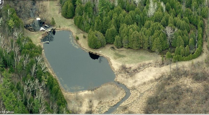
Protecting and Improving Fish Creek, Town of Gibraltar, Door County, Wisconsin                                                    2017

                      Fish Creek Planning Participants                                     Fish Creek Professional Participation and Assistance

    Tom Blackwood, Plan Commissioner                                             Greg Coulthurst, Door County Soil and Water Conservation Dept.
    Mary Ann Blahnik, resident
    Digger DeGroot, Plan Commissioner                                            Erin Hanson, Door County Soil and Water Conservation Dept.
    Dwayne Daubner, Town Board Supervisor
    Tony Fiorato, Fish Creek Watershed Study, citizen scientist                  Kari Hagenow, Door County Invasive Species Team, The Nature
    Mary Ann Gieffers, resident                                                  Conservancy
    Steve Gomoll, resident
                                                                                 Nick Legler, Fishery Biologist, WDNR
    Brian Hackbarth, Plan Commissioner and Town Board Supervisor
    Beth Hagen, Town Clerk, Treasurer, Administrator                             Paul McGinley, UW-Stevens Point
    Andrea Jauquet, resident
    Wayne Kudick, resident                                                       Tom Meronek, Fishery Biologist, WDNR
    David Lea, Fish Creek Watershed Study, citizen scientist
                                                                                 Matt Scheve, Bureau of Environmental Analysis and Sustainability, WDNR
    Renny Lea, resident
    Bob MacDonald, Plan Commissioner
    Barb McKesson, Town Board Supervisor
    Gary McNinch, resident                                                       Jackson Parr, Reporter, Peninsula Pulse
    Bob Merline, Fish Creek Watershed Study, citizen scientist
    Linda Merline, Chair, Plan Com.; Fish Creek Watershed Study, Leader
    Kelly Murre, Deputy Clerk
    Marise Redmann, resident
    Coleen Riley, resident
    Dorothy Riley, resident
    Dick Skare, Chair, Chair, Town of Gibraltar
    Ken Smith, resident
    Steve Sohns, Town Board Supervisor, County Board Supervisor
    Karl Stubenvoll, Town Building Committee
    Bill Wettig, President, Fish Creek Sanitary District
    Amanda Zielke, resident
    Clay Zielke, resident
    Susan Zielke, resident

         N. Turyk, University of Wisconsin-Stevens Point, Center for Watershed Science and Education, September 2017
                                                                                                                                                          4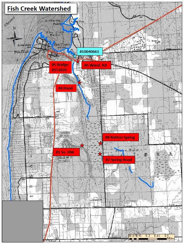
Protecting and Improving Fish Creek, Town of Gibraltar, Door County, Wisconsin                                                         2017

  Goals
  Based on the information exchanged during the planning meetings, the           improve Fish Creek and its watershed. Greater details related to these goals
  following goals were identified by planning participants to protect and        can be found in the respective chapters of this plan. ** Indicates priorities.

                      GOAL 1. PREVENT THE DEGRADATION OF SURFACE AND GROUNDWATER QUALITY
                                          IN FISH CREEK AND ITS WATERSHED

   OUTCOME 1.1: INCREASES IN THE GENERATION OF RUNOFF, NUTRIENTS, SEDIMENT, AND OTHER POLLUTANTS FROM DEVELOPMENT ADJACENT TO FISH
   CREEK WILL BE MANAGED ON SITE. **
   Who: Property owners, Door County Planning and Zoning, Town of Gibraltar, Door County Soil and Water Conservation Dept.
   What: Impervious surfaces associated with development and the expansion of roads creates more, often warm, runoff that carries sediment,
   nutrients, and other pollutants to Fish Creek. In areas with karst, small onsite basins such as raingardens are preferred to larger basins. Minimizing the
   amount of impervious surfaces on a development will reduce the amount of runoff requiring management.
   When: As needed.
   Indicators of Success: Water quality and hydrology in Fish Creek and its watershed are not altered.
   OUTCOME 1.2: CONTROL FOR FLOODS, WATER LEVELS, WATER QUALITY, AND HABITAT ARE PROVIDED BY ALLOWING WETLANDS IN THE FISH CREEK
   WATERSHED TO REMAIN INTACT. **
   Who: Door County Planning and Zoning, Door County Soil and Water Conservation Dept., Town of Gibraltar, Wisconsin and Door County Highway
   Depts., Dept. of Natural Resources
   What: Development in the Fish Creek watershed will not interfere with the wetlands. Should alterations to the wetlands occur, mitigation should take
   place in the Fish Creek watershed.
   When: As needed.
   Indicators of Success: The integrity and area of wetlands is not impaired by development in the Fish Creek watershed.

          N. Turyk, University of Wisconsin-Stevens Point, Center for Watershed Science and Education, September 2017
                                                                                                                                                                5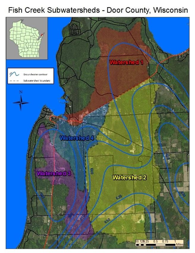
Protecting and Improving Fish Creek, Town of Gibraltar, Door County, Wisconsin                                                       2017

                     GOAL 1. PREVENT THE DEGRADATION OF SURFACE AND GROUNDWATER QUALITY
                                         IN FISH CREEK AND ITS WATERSHED

   OUTCOME 1.3: DIRECT DRAINAGE TO FISH CREEK FROM NEW OR EXPANDED ROADS WILL BE MITIGATED TO REDUCE IMPACTS TO THE FLOW AND
   WATER QUALITY IN FISH CREEK. **
   Who: Town of Gibraltar, Wisconsin and Door County Highway Depts., Door County Soil and Water Dept.
   What: When possible, manage runoff from roads draining towards Fish Creek to remove sediment and pollutants, including thermal pollution, and to
   regulate flow. Seek advice from the Door County Soil and Water Conservation Dept. on a case-by-case basis.
   When: As needed
   Indicators of Success: Water quality and hydrology are not altered in Fish Creek and its watershed.
   OUTCOME 1.4: ERODING SHORELANDS ARE STABALIZED TO REDUCE SEDIMENTATION IN THE BAY AND IN-STREAM WATER DEPTH AND HABITAT IS
   INCREASED.
   Who: Shoreland property owners, Door County Soil and Water Conservation Dept., WDNR River Protection grants, Great Lakes grants, consultants
   What: Develop site specific plans to address shoreland erosion using a combination of biologs, native vegetation, riprap, regrading, and other
   stabilization techniques. Approach will depend on the location, adjacent land use, bank height, type and extent of erosion, water velocity, and
   property owner’s preference. The majority of these sites are located downstream of the Highway 42 crossing.
   When: Ideally, erosion repairs downstream of Highway 42 would be done in conjunction with or following corrections to the Highway 42 culvert.
   Indicators of Success: Shorelands will be intact and Fish Creek will have a narrower and deeper channel.
   OUTCOME 1.5: SHADING FROM SHORELAND VEGETATION WILL HELP TO MAINTAIN COOLER TEMPERATURES IN FISH CREEK.
   Who: Town of Gibraltar, volunteers
   What: Replace ash trees lost to disease along the creek corridor on town land. Choose replacement shrub and tree species that are likely to thrive in
   predicted future climatic conditions. Town will review the grant that was used to purchase the property to be sure restoration is allowable.
   Indicators of Success: Temperatures in Fish Creek remain sufficiently cool for anadromous spawning fish and their young.

         N. Turyk, University of Wisconsin-Stevens Point, Center for Watershed Science and Education, September 2017
                                                                                                                                                           6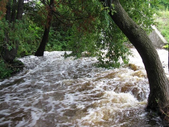
Protecting and Improving Fish Creek, Town of Gibraltar, Door County, Wisconsin                                                       2017

                     GOAL 1. PREVENT THE DEGRADATION OF SURFACE AND GROUNDWATER QUALITY
                                         IN FISH CREEK AND ITS WATERSHED

   OUTCOME 1.6: DEGRADATION OF WATER QUALITY AND REDUCTION OFFLOW IN FISH CREEK WILL NOT OCCUR BECAUSE BEST MANAGEMENT PRACTICES
   ARE USED ON AGRICULTURAL LAND IN THE FISH CREEK WATERSHED.
   Who: Watershed property owners, Door County Soil and Water Conservation Dept., Natural Resource Conservation Services (NRCS), consultants
   What: On agricultural lands, best management practices (BPM) targeted at controlling runoff, maintaining the natural hydrology, and minimizing the
   use of nutrients and pesticides on the landscape will lessen impacts to flow and ecological impacts in Fish Creek. County and NRCS staff are available
   for consultation on site-specific recommendations and funding options, if necessary. Ensure property owners recognize they are in the Fish Creek
   watershed and inform landowners that rent their land for agricultural use about working with the renters to use BMPs.
   When: Ongoing
   Indicators of Success: Water quality and flow in Fish Creek remain the same and drinking water is not negatively impacted.
   OUTCOME 1.7: SUFFICIENT WATER QUANTITY DATA FROM FISH CREEK IS AVAILABLE TO UNDERSTAND RELATIONSHIPS WITH STORM EVENTS,
   SEASONALITY, AND CHANGES IN LAND USE. **
   Who: Fish Creek citizen science monitoring team, Gibraltar Ecology Club
   What: Install monitoring wells at the locations identified in the Fish Creek Water Monitoring Strategy and measure water levels in the wells and
   stream flow.
   When: Water level measurements from the monitoring wells should be collected throughout the year, with weekly water level measurements made
   between spring and fall during year 1. Stream flow measurements and monitoring well water level measurements should coincide with water quality
   monitoring events.
   Data should be used to refine the models developed in this planning process to improve their application.
   All results should be submitted to the WDNR SWIMS database for storage and use.
   Indicators of Success: A reliable dataset will be available to make informed management decisions, evaluate the success of creek and land use
   improvements, and understand current conditions and trends.

         N. Turyk, University of Wisconsin-Stevens Point, Center for Watershed Science and Education, September 2017
                                                                                                                                                            7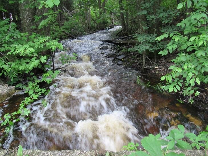
Protecting and Improving Fish Creek, Town of Gibraltar, Door County, Wisconsin                                                       2017

                    GOAL 1. PREVENT THE DEGRADATION OF SURFACE AND GROUNDWATER QUALITY
                                        IN FISH CREEK AND ITS WATERSHED
   OUTCOME 1.8: CURRENT WATER QUALITY CONDITIONS AND TRENDS WILL BE KNOWN AND USED TO MAKE DECISIONS. **
   Who: Fish Creek citizen science monitoring team, Gibraltar Ecology Club, other researchers
   What and When: Water Action Volunteer (WAV) Level 2 Monitoring should be conducted annually following the program’s protocol. Thermistors
   should be placed in the stream from spring to fall to record temperature.
   Samples for lab analysis should be collected at least twice per year; in the spring during runoff and during low flow in late summer. Analyses should
   include: nitrate (N02+NO3-N), NH4, total Kjeldahl nitrogen (TKN), total phosphorus (TP), chloride, and alkalinity.
   Monitors should undergo WAV training and refreshers to ensure good quality data is collected.
   All water quality data results should be submitted to the WDNR SWIMS database for storage and use.
   Use the data to update models and recommendations.
   Indicators of Success: A reliable dataset will be available to make informed management decisions, evaluate the success of implementation of the
   strategies in this plan, and understand current conditions and trends.

         N. Turyk, University of Wisconsin-Stevens Point, Center for Watershed Science and Education, September 2017
                                                                                                                                                           8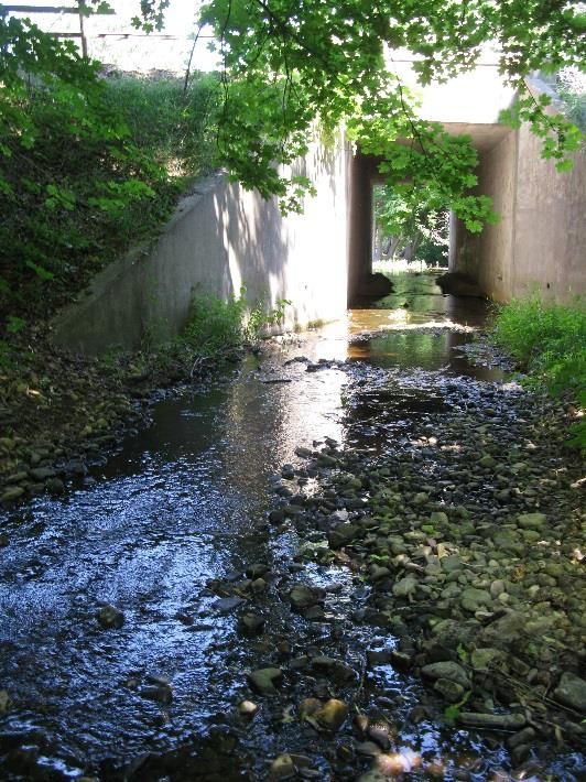
Protecting and Improving Fish Creek, Town of Gibraltar, Door County, Wisconsin 2017
GOAL 2. PROTECT AND IMPROVE FISH AND WILDLIFE HABITAT
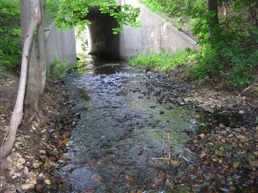
OUTCOME 2.1: IMPEDIMENTS TO THE ACCESS OF FISH CREEK BY FISH AND WILDLIFE ARE REDUCED. THE HIGHWAY 42 CULVERT WILL NOT BE A BARRIER TO
FISH PASSAGE. **
Who: Town of Gibraltar, WDNR Fishery Biologists, WDOT Bureau of Structures, consultants, state or federal grants
What: Evaluate options to reduce the difference in height between the downstream creek bed and the culvert below Hwy 42. Options may include the
replacement of the culvert with a full-span bridge and restoration of the creek bed, installation of downstream gradient controls, or the extension of a
cement apron. The evaluation should identify choices that also narrow the creek to increase water depth such as, adding concrete at the sides of the
concrete apron to narrow the flow when the water is low, allowing for passage of wildlife and people below Hwy 42, are within reasonable costs, and
fundable by grants. Options should address which fish species will benefit from changes and the likelihood of success.
When: Begin planning in 2017
Indicators of Success: Fish can move freely in Fish Creek from the bay to the headwaters.
OUTCOME 2.2: IMPEDIMENTS TO THE ACCESS OF FISH CREEK BY FISH AND WILDLIFE ARE REDUCED. BARRIERS AT REDMANN DAM, PREVENTING FISH FROM
REACHING THE IMPORTANT HEADWATER WETLANDS, WILL BE REDUCED. **
Who: Town of Gibraltar, shoreland property owners downstream from the Redmann Dam, consultant, WDNR River Protection Grant, Great Lakes grants
What: Work with an engineering firm to obtain designs to allow fish to pass between Fish Creek and the small pond and if feasible, create the connection. If
this is not feasible, explore options, such as fish ladders, to allow fish passage through the pond formed behind the Redmann Dam and into the
headwaters. In addition, consider the possibility of regulating the flow of water from the dam or the removal of the dam.
When:
Indicators of Success: Migratory fish will have access the Fish Creek headwater wetlands that provide critical habitat for spawning and young of the year
fish will be able to travel to the bay from the headwater wetlands.
N. Turyk, University of Wisconsin-Stevens Point, Center for Watershed Science and Education, September 2017
9Protecting and Improving Fish Creek, Town of Gibraltar, Door County, Wisconsin 2017
GOAL 2. PROTECT AND IMPROVE FISH AND WILDLIFE HABITAT
OUTCOME 2.3: FISH AND WILDLIFE HABITAT WILL BE ENHANCED BY ALLOWING WOODY STRUCTURE TO REMAIN IN AND NEAR FISH CREEK, HELPING TO
IMPROVE THE HABITAT BIOTIC INDEX (HBI).
Who: Town of Gibraltar, shoreland property owners
What: Tree falls that occur near Fish Creek that do not create hazardous conditions or preclude fish passage should remain in and near Fish Creek. The
woody structure provides cover for young fish, aquatic insects, birds, turtles, amphibians, and other animals. It can also help to narrow and deepen the
creek, providing respite for small fish during periods of low flow. In sections where the creek had been straightened, woody structure will help to
reestablish meanders.
When: Ongoing
Indicators of Success: Fish Creek will have sufficient woody habitat, enhancing fish and wildlife use and reproductive success. Meanders and pools will
form.
OUTCOME 2.4: MORE HABITAT, DEEPER POOLS, AND REDUCED DEGRADATION DOWN STREAM WILL RESULT FROM RESTORING MEANDERS IN FISH CREEK
WHERE THE CREED HAS BEEN STRAIGHTENED UPSTREAM OF HIGHWAY 42.
Who: Lead: Planning Commission. Partners may include the Town crew, volunteers, WDNR biologists, consultants
What: Work with Fishery Biologists with the WDNR to identify low-cost approaches to meander restoration using boulders, fallen trees, and other
intentionally placed structures. Implement the restoration plan. See p. 56 of the Waterfront Master Plan for suggestions.
When:
Indicators of Success: Meanders are restored and deeper pools are created where the creek had been straightened.
OUTCOME 2.5: NATIVE SHORELAND VEGETATION WILL PROVIDE STABILIZATION, REDUCTION OF EROSION, AND HABITAT.
Who: Shoreland property owners, Door County Soil and Water Conservation Dept., WDNR Healthy Lakes and other state grants, Gibraltar Ecology Club
What: Inform new shoreland property owners of the importance of shoreland vegetation and the county and state ordinances that guide its protection
while allowing for access. Design access to Fish Creek to provide safe entry to the water while stabilizing banks and minimizing erosion.
When:
Indicators of Success: Fish Creek shorelands will have healthy native vegetation and access will be designed to minimize streambank erosion.
N. Turyk, University of Wisconsin-Stevens Point, Center for Watershed Science and Education, September 2017
10Protecting and Improving Fish Creek, Town of Gibraltar, Door County, Wisconsin 2017
GOAL 2. PROTECT AND IMPROVE FISH AND WILDLIFE HABITAT
OUTCOME 2.6: WETLANDS AND OTHER AREAS WARRANTING PROTECTION ARE ZONED ACCORDINGLY.
Who: Town of Gibraltar
What: Review the zoning in the Fish Creek watershed to verify all areas that should be in protective zoning have been properly identified. Learn about
protection options from other towns and counties.
When:
Indicators of Success: Appropriate zoning is properly applied in the Fish Creek watershed.
OUTCOME 2.7: INVASIVE SPECIES IN AND ADJACENT TO FISH CREEK AND IN THE WATERSHED ARE IDENTIFIED AND CONTROLLED.
Who: The Nature Conservancy (TNC), volunteers, property owners, Gibraltar Ecology Club, Parks and Land Committee
What and When: Inform watershed property owners about opportunities to learn to identify aquatic and terrestrial invasive species through
informational fliers and the Town website.
Annually monitor the creek corridor between Highway 42 and Redmann Dam. Record locations of invasive species on maps or with a GPS and record
the estimated abundance. If the infestation is new or expanding, notify professionals for guidance and take steps to remove or reduce the population.
Dense populations of Japanese barberry exist along Fish Creek’s shoreline. Work with TNC to develop a strategy to reduce the population. Phragmites,
Dame’s rocket, garlic mustard, and honeysuckle are also present in the watershed. TNC can train property owners on the proper techniques to remove
these plants and reduce the spread. Once trained, volunteers should monitor annually during the growing season.
Support regional or county invasive species staff through letters of support and funding, if needed.
Indicators of Success: Invasive species will not become overly abundant in Fish Creek or on its shorelines.
OUTCOME 2.8: DEVELOP AN UNDERSTANDING OF THE USE AND REPRODUCTIVE SUCCESS OF FISH IN FISH CREEK.
Who: WDNR Fishery Biologists, other researchers, citizen scientists
What: Develop monitoring strategies to understand which fish are using Fish Creek, which sections of the creek are being used, and where
improvements in habitat and passage can be made. Also, explore whether the planting of fish for imprinting should be considered.
When: Multiple years, year-to-year variability occurs.
Indicators of Success: Sufficient data exists to assess current conditions and success of improvements to Fish Creek.
N. Turyk, University of Wisconsin-Stevens Point, Center for Watershed Science and Education, September 2017
11Protecting and Improving Fish Creek, Town of Gibraltar, Door County, Wisconsin 2017
GOAL 2. PROTECT AND IMPROVE FISH AND WILDLIFE HABITAT
OUTCOME 2.9: CONSERVATION EASEMENTS ARE ENCOURAGED AS A VIABLE OPTION FOR PROPERTY OWNERS INTERESTED IN PROTECTING FISH CREEK
AND ITS WATERSHED.
Who: Town of Gibraltar, WDNR River Protection grants, Knowles Nelson Stewardship Fund, Conservancy trusts
What: Support property owners who are interested in placing fragile land in the Fish Creek watershed into land trusts or other protection programs.
When: As needed.
Indicators of Success: Land is protected in accordance with property owners wishes, increasing the resiliency of Fish Creek and minimizing negative
impacts to surface and groundwater quality and habitat.
N. Turyk, University of Wisconsin-Stevens Point, Center for Watershed Science and Education, September 2017
12Protecting and Improving Fish Creek, Town of Gibraltar, Door County, Wisconsin 2017
GOAL 3. FISH CREEK WILL BE ACCESSIBLE TO THE COMMUNITY’S RESIDENTS AND VISITORS
OUTCOME 3.1: PROVIDE SAFE PUBLIC ACCESS TO FISH CREEK.
Who: Town of Gibraltar, WDNR
What: To enjoy the land, maintain access to Fish Creek from Town land, trails, bridges, and boardwalks.
When: Ongoing
Indicators of Success: Town residents and visitors can enjoy Fish Creek and the adjacent publically owned land.
OUTCOME 3.2: PROVIDE SAFE PUBLIC ACCESS TO FISH CREEK.
Who: Town of Gibraltar, WDNR, Snowmobile bridge grant funding, Silent Sports funding
What: Explore options for people to safely access Fish Creek near Highway 42 by providing a walkway through the culvert or by replacing the culvert
with an open-span bridge that would contain a multi-modal trail, providing a pedestrian footbridge that would connect the two sides of Fish Creek
Park from the gazebo to the Bonnie Brooke side, and repairing or replacing the existing boardwalk crossings on the multi-modal trail in Fish Creek
Park.
When:
Indicators of Success: Public can walk along Fish Creek without safety issues associated with crossing Highway 42.
OUTCOME 3.3: PROVIDE PUBLIC ACCESS AND PROTECTION: LAND FOR SALE IN THE CREEK CORRIDOR MAY BE CONSIDERED FOR PURCHASE BY THE TOWN
OR OTHERS.
Who: Town of Gibraltar, WDNR River Protection grants, Great Lakes grant programs, Knowles Nelson Stewardship Funds
What: If interested, the Town will consider purchase of key parcels of land along the Fish Creek corridor and seek grant funding to assist with the
purchase.
When: As the situation arises.
Indicators of Success: The public has access to various segments of Fish Creek and its adjacent land.
N. Turyk, University of Wisconsin-Stevens Point, Center for Watershed Science and Education, September 2017
13Protecting and Improving Fish Creek, Town of Gibraltar, Door County, Wisconsin 2017
GOAL 3. FISH CREEK WILL BE ACCESSIBLE TO THE COMMUNITY’S RESIDENTS AND VISITORS
OUTCOME 3.4: A MULTI-GENERATIONAL PARTNERSHIP WILL SUPPORT A HEALTHY FISH CREEK.
Who: Residents, visitors, local fishing and conservation clubs, Gibraltar School, Town of Gibraltar, Door County, WDNR-Peninsula State Park, local
businesses, elected officials
What: Many people and agencies are engaged in managing a healthy waterbody, especially one that is surrounded by potential threats associated
with developed and agricultural landscapes. Each may have their own set of priorities, but together they are stronger. Gather at a social meeting to
share ideas and discuss what might best suit the Fish Creek community. Options may include a Friend’s group, an association, or a sub-committee of
the Town. Identify the group’s objectives to determine which type of group best suits its need. If needed, County UW-Extension staff or staff from
Wisconsin River Alliance can help facilitate these conversations and decisions.
When:
Indicators of Success: The community works together to support efforts to maintain Fish Creek as healthy local resource.
OUTCOME 3.5: COMMUNICATION STRATEGIES ARE DEVELOPED.
Who: Town of Gibraltar, citizens, Friends group
What: The exchange of information will be critical to successful implementation of this plan. Consider ways to communicate with the partners
involved in the development of this plan, residents and property owners, and other advocacy groups in Door County. Options include newsletters, a
facebook page, local newspapers, countywide gatherings of advocacy groups, social or fundraising events, farm tours, etc.
OUTCOME 3.6: PARTNERS MEET TO DISCUSS MATTERS RELATED TO FISH CREEK. **
Who: Lead: Planning Commission, Partners: Parks and Land Committee and Watershed Volunteers and other partners
What: Partners will gather at least annually to update their progress, share information, discuss new problems, review successes, and identify
components of the plan to address in the upcoming year. Formally update the plan every 5 years or sooner, if warranted. The Plan Commission will
lead and manage the plan by annually holding a joint meeting of Plan Commission, Park & Lands, & Watershed Study Volunteers to determine which
outcomes to pursue, which grants to apply for, and which partner should lead an effort. Strategies will be presented to the Town Board for review
and approval prior to proceeding.
When: Annually
Indicators of Success: To encourage exchange of information and cooperation, all partners are aware of conditions in Fish Creek and the tasks that
others are working on.
N. Turyk, University of Wisconsin-Stevens Point, Center for Watershed Science and Education, September 2017
14Protecting and Improving Fish Creek, Town of Gibraltar, Door County, Wisconsin 2017
GOAL 1. PREVENT THE DEGRADATION OF WATER
QUALITY IN FISH CREEK
We know how to do this. We just
need the will to work together to
make it happen!
N. Turyk, University of Wisconsin-Stevens Point, Center for Watershed Science and Education, September 2017
15Protecting and Improving Fish Creek, Town of Gibraltar, Door County, Wisconsin 2017
The Fish Creek Watershed
The Fish Creek watershed is located entirely within in the Town of Gibraltar
in Wisconsin’s Lake Michigan basin. It occupies 7,240 acres (11.3 square
miles) on the east side of the Green Bay. Fish Creek begins in a wetland
complex just south of the village of Fish Creek and flows approximately
1.5 miles north to Fish Creek Harbor.
Geology dictates groundwater behavior
The Door County Peninsula is located along a geologic ridge called the
Niagara Escarpment that runs from southeast Wisconsin to Ontario. The
Fish Creek Watershed is located on the west side of the Door County
peninsula. It is composed of resistant Silurian dolomite that formed from
sediment deposited on an ancient sea floor about 430 million years ago.
Multiple layers of sediment were laid down throughout the historical
formations and disappearance of the ancient sea known as the Michigan
Sea.
The land surface of the Fish Creek Watershed slopes generally to the
southeast from a steep dolomite face that parallels the Green Bay shore
and is broken at intervals by bays and coves. The rock is medium to coarse
grained, mostly buff gray, and reaches a maximum thickness of 350 feet.
This unit comprises the primary water supply aquifer in the area, yielding
small to moderate amounts of water from vertical and bedding-plane
joints. Water in the upper part of this aquifer is unconfined where vertical
joints predominate (Sherrill, M.G., 1978).
Land Use and Water in the Fish Creek Watershed
Land use in a watershed has significant effects on the water that flows
across the landscape and into streams. As an example, the flow of water
over a landscape is slower and steadier in a mature forest with a well-
developed duff layer versus a landscape that is dominated by compacted
cropland or impervious surfaces, such as rooftops and roads. When surface
water flow is slowed, there is more opportunity for infiltration to
groundwater and less energy for erosion and mobilization of contaminants.
N. Turyk, University of Wisconsin-Stevens Point, Center for Watershed Science and Education, September 2017
16Protecting and Improving Fish Creek, Town of Gibraltar, Door County, Wisconsin 2017
In part of the watershed, changes in land cover, and land uses in the Fish
Creek watershed have likely altered the rate and amount of surface water
runoff from the land that resulted from snow melt and rain events. In
undeveloped areas of the watershed, some of the runoff moves slowly over
the land to drainage ways. Tree leaves and branches reduce the impacts of
raindrops on the ground, and the thick organic layer of decaying leaves and
moss on the soil surface acts like a sponge that slows and filters the runoff.
Water collects in shallow depressions, creating wetlands, and the forest
canopy can provide shade that helps keep runoff water cooler. The upper
reaches of Fish Creek run through a wetland complex of over 100 acres.
For the purposes of the water model constructed for this plan by UWSP, the
Fish Creek watershed was broken into four sub-watersheds. The mix of land
use varies in each of the sub-watersheds. Some of the sub-watersheds
retain many of their natural characteristics; the Peninsula State Park sub-
watershed (1) is dominated by forests (80%), the Nature Conservancy East
sub-watershed (2) is characterized by 49% forests and 20% grasslands, the
Nature Conservancy West subwatershed (3) is comprised of 50% forests
and nearly 30% grasslands, and the Lower Fish Creek sub-watershed (4)
includes 50% forests and 16% grasslands. Boundaries for these sub-
watersheds are shown on the map to the right. A full list of the percentages
of land use in each sub-watershed can be found in Appendix B.
The community of Fish Creek comprises a major portion of the Lower Fish
Creek sub-watershed (4). Like other parts of the Fish Creek watershed, this
sub-watershed is predominated by forests; however, the primary difference
is the concentrated urban development near the creek’s mouth. Impervious
surfaces that are directly connected to Fish Creek are estimated to be 9
acres of the 910 acre sub-watershed. Left unmitigated, a larger quantity of
storm water is generated from this land, which drains to the storm sewer
network. This is the only part of the watershed with a network of storm
sewers. These sewers discharge either directly to Green Bay or into the
lower reaches of Fish Creek. Runoff across the hard surfaces readily picks
up sediment, oil, leaves, animal droppings, litter, and other pollutants and
N. Turyk, University of Wisconsin-Stevens Point, Center for Watershed Science and Education, September 2017
17Protecting and Improving Fish Creek, Town of Gibraltar, Door County, Wisconsin 2017
discharges them to the creek and bay. During the summer, the runoff The graphs illustrate water temperatures in Fish Creek measured just
coming off warm pavement and rooftops tends to be warmer than runoff upstream of the Highway 42 crossing during spring and summer 2014 and
from vegetated land. In large storms, the warm runoff can increase the 2015. By definition, July temperatures for a cold-water fishery average less
temperature of the creek. than 63.5F (Lyons et. al. 2009). Average temperature measured in Fish
Stream Temperatures Creek in July 2014, 2015, and 2016 were 61.2, 68.9, and 71.8, respectively.
The range and variation of stream temperatures in Fish Creek is critical to Shallow water depths, warm runoff and air temperatures all contribute to
its ability to support fish populations. To support healthy fish populations, it these increased temperatures.
is desirable for the creek to maintain a cool, steady flow of water, which
helps to provide sufficient dissolved oxygen. In some reaches of the creek, Fish Creek Temperature F 2014
80.0
groundwater feeding it delivers cool water.
75.0
Numerous activities on the landscape can result in warmer stream 70.0
temperatures during the summer. Impervious surfaces, particularly 65.0
pavement, can warm the runoff which in turn results in warmer creek 60.0
temperatures. The removal of shrubs and trees near the creek reduces 55.0
shade. Reduction of cool groundwater inflow to the creek can also result in 50.0
warmer stream temperatures and lower volumes of water.
45.0
Studies reveal that the amount of impervious surface near a waterbody 40.0
affects the fish community by increasing the water temperature and May-14 Jun-14 Jul-14 Aug-14 Sep-14
turbidity.
Fish Creek Temperature F 2015
80.0
75.0
70.0
65.0
60.0
55.0
50.0
45.0
40.0
May-15 Jun-15 Jul-15 Aug-15 Sep-15
N. Turyk, University of Wisconsin-Stevens Point, Center for Watershed Science and Education, September 2017
18Protecting and Improving Fish Creek, Town of Gibraltar, Door County, Wisconsin 2017
Water Flow and Water Quality preliminary hydrologic analysis since it was largely based on the results of
Data Collections simulation modeling rather than measured flow data. The analysis applied
Much of the water quality data collected a relatively simple tool to start to understand the hydrology of Fish Creek
from Fish Creek began in 1999. Since and its sensitivity to development in the watershed. The objectives of this
then, citizen scientists have collected model were to:
field measurements of water 1. Develop a hydrologic model for streamflow and concentration in the
temperature, water depth, dissolved Fish Creek watershed;
oxygen, conductivity, pH, and 2. Use observations of stream depth and concentration measurements
transparency and water samples have from volunteer monitoring and measurements of flow elsewhere in
been analyzed in the lab for alkalinity, Door County to calibrate the model;
phosphorus, nitrogen, coliform and E. coli 3. Use the model to explore how future land changes in the watershed
bacteria, and transparency, Samples were might influence streamflow characteristics and stream chemistry.
collected from four sites in the watershed
The hydrologic modeling performed for this project was to assist in
since 1999, with more recent measurements
beginning to understand the biology and chemistry of the stream now
taken at two sites since 2002.
and after land use change. The modeling did not perform analysis of
A map of the sampling locations and summary of the results can be found in hydraulics and the study should not be used to evaluate the implications of
Appendix C. As would be expected, water quality was variable between large stream flow events or downstream flooding.
sampling sites. This is due to differences in the land cover, land use
Flow measurements have not been reported for Fish Creek; therefore,
practices, and amount of flow and groundwater inputs at the different
creek flow was estimated using precipitation records. The model can be
locations. The water quality results did
improved and updated by incorporating flow data generated by following
not indicate any chronic problems;
the water monitoring plan described in this chapter. The complete report of
however, individual occurrences of
modeling results can be found in Appendix G.
elevated concentrations of nitrogen,
phosphorus, and bacteria (e. coli) were Water Quality
observed periodically. Phosphorous and alkalinity were included in the model. Phosphorus is a
nutrient that helps algae and aquatic plants to grow. It can occur naturally,
Fish Creek’s Water Flow
but some sources can be controlled through how land and runoff are
As part of the development of this plan,
managed. The controllable sources include erosion, runoff, fertilizers, and
a model was created to develop a first
manure. The primary source for alkalinity in Fish Creek is from dissolved
step towards understanding the
limestone carried to the creek with groundwater.
hydrology of Fish Creek and exploring
the potential impact of land use change Once the model’s simulation of flow was developed, phosphorus and
on the health of the creek. This was a alkalinity were graphed with the estimated flow to understand their
N. Turyk, University of Wisconsin-Stevens Point, Center for Watershed Science and Education, September 2017
19Protecting and Improving Fish Creek, Town of Gibraltar, Door County, Wisconsin 2017
relationships. In general, the highest phosphorus concentrations The graphs below show the measured total phosphorus and alkalinity
occurred during the low flow periods of the summer and the lowest concentrations over time in Fish Creek at Hwy 42 shown with simulated flow.
concentrations were observed during the high flow periods of the Note: The dotted lines were added to demonstrate connection between points,
spring. This pattern is not typical of many Wisconsin streams. One and do not imply concentrations between sample acquisition.
explanation is, during the high flows in spring, large groundwater
inputs act to dilute runoff and in-stream phosphorus concentrations.
Alkalinity concentrations are low because much of the groundwater
flow is through rapid transit pathways that convey snowmelt and
recharge. During the low flow summer periods, stream phosphorus
concentrations may be influenced by small runoff events because the
overall streamflow is so low. The streamflow often has higher
alkalinity during the summer, which could be the result of longer
groundwater flow pathways and more contact with the carbonate
bedrock. However, when small runoff inputs are added to this small
groundwater flow, the relatively high concentration of phosphorus in
the runoff could lead to increases in measured phosphorus.
N. Turyk, University of Wisconsin-Stevens Point, Center for Watershed Science and Education, September 2017
20Protecting and Improving Fish Creek, Town of Gibraltar, Door County, Wisconsin 2017
Potential Changes to Fish Creek from Development
The modeling explored how increasing the quantity of impervious surface Simulated impact of changes in hard (impervious) surfaces in
might influence the hydrology and water quality in Fish Creek. This was downstream sub-watershed 4 on peak and average annual
accomplished by increasing the directly connected impervious fraction of streamflow in
the downstream sub-watershed 4 from 1% to 20%. Overall, the flow Fish Creek.
appeared similar because this change only affects a small percentage of the
watershed; however, this change could have an important impact on flows
and flow variation during the lower flow periods of the year.
The graphs summarize changes in the maximum (peak) flow in the creek by
year, with simulated increases in hard (impervious) surfaces in sub-
watershed 4. As expected, more runoff resulting from more hard surfaces
would increase flow in May and August. This change reflects the large
addition of runoff to Fish Creek with a relatively low increase in flow during
periods of low flow. As described earlier for the evaluation of stream water
quality, higher phosphorus concentrations would be expected in Fish Creek
during the summer with increases in hard surfaces when the resulting
additional runoff is not properly managed.
.
N. Turyk, University of Wisconsin-Stevens Point, Center for Watershed Science and Education, September 2017
21Protecting and Improving Fish Creek, Town of Gibraltar, Door County, Wisconsin 2017
Differing flows in Fish Creek upstream of the Highway 42 crossing.
N. Turyk, University of Wisconsin-Stevens Point, Center for Watershed Science and Education, September 2017
22Protecting and Improving Fish Creek, Town of Gibraltar, Door County, Wisconsin 2017
Planning for Increases in Hard Surfaces incentive. Designs can vary and should be appealing to the property
There are a number of options to reduce (mitigate) the effects of existing owners.
and additional development in the Fish Creek watershed, especially in close
proximity to the creek. The wetlands play an important role in the
reduction of runoff to Fish Creek by storing the water and slowly releasing
it. It is tempting to direct runoff from development to the wetlands;
however, this is not an ideal solution for Fish Creek. Except for the
headwaters area, wetlands fringe the creek and offer minimal retention
benefits.
Retention ponds are commonly used to manage runoff in other settings;
however, in karst settings it is preferable to manage runoff from roofs and
pavement in smaller onsite basins. Incorporating runoff management into
the landscape design can be easily accomplished using depressions in part
of a parcel, properly sized raingardens, terracing, and other water collection
systems. Decreasing the amount of hards surface can reduce the amount of
runoff and hence, the size of an onsite basin. This can be accomplished by
minimizing the impervious footprint by building up instead of out, reducing
driveway size, and using pervious pavers. Swales can be used to collect and
infiltrate runoff from roads.
Runoff management will benefit Fish Creek and the waterfront. There are
many ways to encourage owners of developed
property to incorporate runoff management into
their landscape. Information about its importance
is always the first step. This can be accomplished
by installing or identifying demonstration sites and
highlighting them with signage if they are on public
property, hosting discussions at garden walks,
using awards to highlight good shoreland
practices, and communication about benefits in
newspapers or newsletters. Competitions or
participation in grant programs can also offer
N. Turyk, University of Wisconsin-Stevens Point, Center for Watershed Science and Education, September 2017
23Protecting and Improving Fish Creek, Town of Gibraltar, Door County, Wisconsin 2017
Fish Creek Water Monitoring Strategy
THESE WATER QUALITY AND QUANTITY MONITORING STRATEGIES HAVE BEEN DESIGNED TO COLLECT INFORMATION THAT WILL
CONTINUE THE MOST RELEVANT ASPECTS OF PAST MONITORING EFFORTS AND PROVIDE THE PERTINANT INFORMATION TO ANSWER
QUESTIONS ABOUT CREEK HEALTH IN THE FUTURE. TO ENSURE THE INTEGRITY OF THE DATA, DATA COLLECTION SHOULD BE DONE BY
TRAINED INDIVIDUALS FOLLOWING ACCEPTED PROTOCOLS, SUCH AS THE WATER ACTION VOLUNEER (WAV) PROGRAM.
ANTICIPATED CHANGES IN LAND USE IN THE FISH CREEK WATERSHED INCLUDE INCREASES IN AGRICULTURAL LANDS AND
DEVELOPMENT. DEPENDING ON HOW THE LAND IS MANAGED, THESE PRACTICES MAY HAVE MINIMAL OR SIGNIFICANT IMPACTS ON
FISH CREEK AND ITS INHABITANTS.
LOCATIONS
MONITORING STATIONS SHOULD BE SITUATED IN TWO LOCATIONS IN FISH CREEK. THE UPSTREAM STATION SHOULD BE LOCATED
DOWNSTREAM FROM THE PONDS, IDEALLY NEAR THE FOOT BRIDGE. THE MOST DESIRABLE DOWNSTREAM LOCATION WOULD BE IN
THE TOWN PARK AT THE FOOT BRIDGE; HOWEVER, BECAUSE THE SITE JUST UPSTREAM OF THE HIGHWAY 42 BRIDGE HAS BEEN USED
FOR SOME TIME, IT IS DESIRABLE TO COLLECT DATA AT BOTH LOCATIONS FOR 1-2 YEARS.
WATER QUANTITY
MONITORING WELLS SHOULD BE INSTALLED ON THE LAND ADJACENT TO THE CREEK AT BOTH MONITORING LOCATIONS. WELLS
SHOULD HAVE LOCKED CASING AROUND THEM TO PREVENT UNDERSIRED TAMPERING WITH THE WELL AND PREVENT
CONTAMINATION OF GROUNDWATER. THE LENGTH OF THE WELL SCREENS SHOULD BE SUFFICIENT TO CAPTURE ANTICIPATED
FLUCTUATIONS IN WATER TABLE ELEVATION. WATER LEVEL MEASUREMENTS SHOULD BE COLLECTED THROUGHOUT THE YEAR, WITH
THE GREATEST FREQUENCY OF WATER LEVEL MEASUREMENTS MADE WEEKLY BETWEEN SPRING AND FALL. IF POSSIBLE, THE WELLS
SHOULD BE SURVEYED ANNUALLY TO IDENTIFY CHANGES IN ELEVATION.
STREAM FLOW MEASUREMENTS AND MONITORING WELL WATER LEVEL MEASUREMENTS SHOULD COINCIDE WITH WATER QUALITY
MONITORING.
WATER QUALITY
WAV LEVEL 2 MONITORING SHOULD BE CONDUCTED PER THE PROGRAM’S PROTOCOL. THERMISTERS SHOULD BE PLACED IN THE
CREEK FROM SPRING TO FALL TO RECORD TEMPERATURE.
SAMPLES FOR LAB ANALYSIS SHOULD BE COLLECTED AT LEAST TWICE PER YEAR, IN THE SPRING DURING RUNOFF AND DURING LOW
FLOW IN LATE SUMMER. ANALYSES SHOULD INCLUDE: NITRATE (NO2+NO3-N), NH4, TOTAL KJELDAHL NITROGEN (TKN), TOTAL
PHOSPHORUS (TP), CHLORIDE, AND ALKALINITY.
N. Turyk, University of Wisconsin-Stevens Point, Center for Watershed Science and Education, September 2017
24Protecting and Improving Fish Creek, Town of Gibraltar, Door County, Wisconsin 2017
Watershed Communities and Management Highlights Appropriately size channel
Add structure for habitat
Many local and regional plans are relevant to Fish Creek and many
governmental and non-governmental organizations are tasked with aspects Restore fish passage
associated with management of Fish Creek, its inhabitants, and its Add educational signage
watershed. Following are key plans and legislation that provide guidance; Enhance multi-modal access
however, this list should not be treated as all-inclusive.
The village of Fish Creek owns and maintains the 27-acre Fish Creek Park.
The Town of Gibraltar Comprehensive Plan, approved by the town board in
2003, identifies goals and objectives to improve and protect the land, The Door County Comprehensive Plan, adopted by the Door County Board of
water, and other natural resources of the township. Objectives that most Supervisors on October 27, 2009, identifies goals and objectives to improve
and protect the land, water and other natural resources of the county.
closely related to management and restoration goals of the Fish Creek
Objectives that most closely related to management and restoration goals of
Watershed are:
the Fish Creek Watershed are:
The Town of Gibraltar’s natural areas and resources: land, water, and
Protect lakes, rivers, streams, wetlands, steep slopes, wildlife habitat,
air as well as plant and animal life and habitat, are preserved,
and other natural features.
protected, conserved, restored, enhanced and maintained for future
Protect and enhance the county’s surface and ground water quality.
generations.
Maintain and/or improve the quality of our water and its sources The Door County Soil and Water Resource Management Plan 2011-2020
(wetlands, springs, streams and lakes) within and around the Town. (DCLWRMP) was developed to prioritize efforts by the County and staff. Goals
Ensure that all growth and development will respect and preserve the for the Upper Door County Watershed, which includes Fish Creek, include
unique natural environment of the Town; its woodlands, the addressing groundwater and surface water quality issues related to agriculture
through the implementation of best management practices, nutrient
escarpment, the shoreline, and its open spaces characterized by a
management, and compliance with ordinances aimed at achieving these goals,
variety of housing types and densities, pedestrian accessibility of
such as the manure storage ordinance. The DCLWRMP acknowledges the
neighborhoods and parks, inclusion of open green spaces within the wetlands along the 1.5 mile Fish Creek corridor which were designated as
developments, new trail ways, and environmental protection. important wildlife habitat within the Bay to Lake Wildlife Corridor in the
Collaborative Community publication “A Guide to Significant Wildlife Habitat
The Town of Gibraltar Waterfront Master Plan, developed in 2016, includes and Natural Areas of Door County, Wisconsin (2003)”.
Fish Creek and its watershed. The recommendations directly related to Fish
Creek are: Door County Soil and Water Conservation Dept. and the Natural Resource
Conservation Service (NRCS) assist landowners with conservation planning and
Add meanders and pools cost-sharing to improve the productivity and ecological values of their land
Pre-treat stormwater before it reaches the creek including the implementation of agricultural BMPs, restoration of shorelands,
Lower the floodplain to promote wetlands and protection and restoration of wetlands in the watershed.
N. Turyk, University of Wisconsin-Stevens Point, Center for Watershed Science and Education, September 2017
25Protecting and Improving Fish Creek, Town of Gibraltar, Door County, Wisconsin 2017
The Wisconsin’s Dept. of Agriculture, Trade, and Consumer Protections The University of Wisconsin and NOAA Sea Grant programs offer research-
(DATCP) reviews county land and water conservation plans and provides funds based education in support of stewardship and sustainable use of Great Lakes
to Door County to assist with their implementation. resources.
Several state agencies are responsible for watershed management.
The Lakeshore Basin Plan (WDNR 2000) also identifies Fish Creek as an
“at risk community” based on stormwater and runoff issues due to
intensive development. Peninsula State Park is owned and managed
by the WDNR. The 3,776-acre
park comprises over 2,000
acres of the watershed.
WDNR also has oversight of
fisheries and wildlife
management. Fish Creek
Citizen Scientists use the
WAV program protocols, co-
managed by WDNR and
UWEX.
As Wisconsin’s primary environmental
quality management agency, the
WDNR works in partnership with the
U.S. EPA to achieve goals of the
federal Clean Water Act, Safe Drinking
Water Act, Resource Conservation
and Recovery Act, Endangered
Species Act, and of binational
programs related to Great Lakes restoration and management.
With support from National Oceanic and Atmospheric Administration (NOAA)
and the US Department of Commerce, the Wisconsin Office of Coastal
Management works cooperatively with state, federal, local and tribal
governments; and non-governmental organizations in managing the ecological,
economic, and aesthetic resources of coastal communities, including Green Bay
N. Turyk, University of Wisconsin-Stevens Point, Center for Watershed Science and Education, September 2017
26Protecting and Improving Fish Creek, Town of Gibraltar, Door County, Wisconsin 2017
GOAL 2. PROTECT AND IMPROVE
FISH AND WILDLIFE HABITAT
\
Assisting fish to move upstream to spawn.
N. Turyk, University of Wisconsin-Stevens Point, Center for Watershed Science and Education, September 2017
27Protecting and Improving Fish Creek, Town of Gibraltar, Door County, Wisconsin 2017
In Stream Habitat and the Fish Community According to the fishery biologists with the WDNR, the low water in Fish
Many local observations about the fish in Fish Creek exist. However, only Creek limit the year-round fish community. However, improvements could
several formal surveys of the fish community have been conducted by be made that would allow for more use by species from Green Bay.
WDNR fishery biologists. Records of the 1968 survey were minimal. Correcting barriers of passage by the fish, narrowing the
They stated Surface acres = 1.0; Miles = 1.0; Gradient = 15.0 feet creek channel while increasing its depth, enhancing
per mile; a small, low gradient, intermittent creek which originates meanders, increasing woody habitat, and correcting
in swampland and flows to Green Bay at Fish Creek. Forage species erosion will better accommodate fish use.
constitute the fish population. A state highway is the only road Aquatic Insects and Stream Habitat
crossing this stream. During the 1968 survey, 19 stocked rainbow Knowledge of stream habitat and the aquatic insects living
trout were captured. A summer baseline survey was also in a stream can provide insight about the health of the
conducted in 2003; no fish were captured. Water level data were stream and its ability to support certain fish species. An
not available to determine if the lack of resident fish was related to aquatic insect (macro invertebrate) survey was conducted
the amount of flow. A spring survey may have revealed different in Fish Creek by WDNR staff in 1999. Summarized habitat
results including estimates of use by fish species migrating from descriptions from the survey follow.
Green Bay.
…mostly run, with small pools found between the runs. Habitat features
Fish stocking records for Fish Creek, Door County. Source: WDNR ranged from 3 to 7 meters in length for pools, and 6.5 to 31.0 meters in
length for runs. No riffle areas were noted. Bank erosion within 5 meters of
Year Species Age Class Number Ave. the creek was common throughout the survey section and ranged from 10
Length to 60% of the stream bank. It appeared that at one time this section of creek
1972 Rainbow Trout Fingerling 4,384 7 was channelized. Fish cover was limited to large woody vegetation found in
1976 Brown Trout Fingerling 4,500 7 and near the pools.
1977 Walleye Fingerling 50,600 5 A summary of the stream health and water quality based on the aquatic
1982 Brown Tout Yearling 16,800 insects found in a stretch of stream is called the Hilsenhoff Biotic Index
1982 Brown Trout Fingerling 30,000 7 (HBI). The HBI scores range from 0-10; sensitive species that require high
1984 Brown Trout Fingerling 10,000 7 dissolved oxygen and low organic materials are assigned low scores and
1990 Brook Trout Yearling 5,000 9 organisms tolerant of low oxygen or organic pollutants receive high scores.
In Fish Creek, HBI scores ranged from 3.8 to 7.7.
1990 Brook Trout Fingerling 9,000 3
1992 Chinook Salmon Fingerling 19,928 3 Location in Fish Creek HBI Quality
1992 Chinook Salmon Fingerling 10,000 4 Headwaters near Wandering Rd. 3.8 Very Good
1994 Brown Trout Fingerling 15,000 6.8 Just below Redmann Pond 7.7 Very Poor
Near Highway 42 5.3 Fairly Poor
N. Turyk, University of Wisconsin-Stevens Point, Center for Watershed Science and Education, September 2017
28Protecting and Improving Fish Creek, Town of Gibraltar, Door County, Wisconsin 2017
Each species of aquatic insect has a different level of tolerance to oxygen accessing this habitat. Several options that could address fish access were
levels and naturally occurring and added organic materials. Controllable discussed during the planning meetings. Options included: allowing fish
organic materials come from eroded soil, decomposing leaves, manure, and access to the Redmann pond through the creation of fish ladders, the
effluent from septic systems from the surrounding landscape. Volunteer removal of the dam that creates the larger Redmann pond, or providing
monitoring data revealed that the monitored sites in Fish Creek typically access from Fish Creek to the smaller pond. Following a considerable
have sufficient dissolved oxygen so high HBI scores are likely a result of amount of discussion, the most desirable option for access between Fish
organic materials in Fish Creek. Creek and the headwater wetlands was believed to be through the smaller
pond. Benefits of the ponds were recognized as the primary reasons for
Typically, most road crossings alter the quality of a stream and the
keeping them intact. These benefits include providing habitat and attracting
streambed; therefore, moving the Highway 42 monitoring site upstream
a number of inhabitants such as ducks, herons, and Blanding’s and other
into the town park would provide a better indication of the overall health of
turtles. Blanding’s turtles are a threatened species. The ponds are also
this stretch of Fish Creek.
appreciated for their aesthetic values.
Fish Barriers and Habitat Issues
Redmann Pond
Upstream Wetland Habitat for Spawning Fish
According to fishery biologists with
the WDNR, the wetland complexes
upstream of the ponds would I had the privilege of spotting
likely offer good habitat for an otter in Claflin Pond in
spawning fish such as northern 2014! I have photos of
pike and young fry. However, extensive otter tracts in the
the ponds created by dams in Fish snow covered ice on the pond.
Creek prevent most fish from
Existing connection
between Fish Creek and
the smaller pond.
N. Turyk, University of Wisconsin-Stevens Point, Center for Watershed Science and Education, September 2017
29You can also read