DRAFT PORTARLINGTON JOINT LOCAL AREA PLAN - Laois County Council Comhairle Chontae Laoise & Offaly County Council Comhairle Chontae Uibh Fhaili ...
←
→
Page content transcription
If your browser does not render page correctly, please read the page content below
Laois County Council
  Comhairle Chontae Laoise

             &

   Offaly County Council
Comhairle Chontae Uibh Fhaili

  DRAFT PORTARLINGTON
  JOINT LOCAL AREA PLAN

        2018 – 2024
Joint Portarlington Local Area Plan 2018 - 2024

                                                                                                                                       CONTENTS

1     Introduction .......................................................................................................................................... 6
2     Legislative Requirements ...................................................................................................................... 7
    2.1       Strategic Environmental Assessment............................................................................................ 8
    2.2       Appropriate Assessment ............................................................................................................... 8
    2.3       Strategic Flood Risk Assessment ................................................................................................... 8
3     Other Plans & Guidelines .................................................................................................................... 10
4     Portarlington in Context ..................................................................................................................... 11
5     History of Portarlington ...................................................................................................................... 12
6     Urban Form ......................................................................................................................................... 13
7     Spatial Planning Policy ........................................................................................................................ 14
    7.1       Project Ireland 2040 National Planning Framework ................................................................... 14
    7.2       Regional Planning Guidelines For Midland Region 2010 – 2022 ................................................ 15
    7.3       Regional Spatial and Economic Strategy ..................................................................................... 17
8     Development Vision & Strategy .......................................................................................................... 18
    8.1       Key Plan Objectives ..................................................................................................................... 19
    8.2       Core Strategy............................................................................................................................... 20
    8.3       Function, Population and Scale of Portarlington ........................................................................ 20
    8.4       Residential Land Availability ....................................................................................................... 22
    8.5       Future Development Priorities ................................................................................................... 22
      8.5.1          Town Centre Consolidation................................................................................................. 22
      8.5.2          Economic Development ...................................................................................................... 23
      8.5.3          Key Infrastructure ............................................................................................................... 23
      8.5.4          Environment and Heritage Protection ................................................................................ 23
      8.5.5          Community Facilities ........................................................................................................... 23
9     Economic Development ...................................................................................................................... 24
10         Town Centre Revitalisation ............................................................................................................. 31
    10.1      Opportunity Sites ........................................................................................................................ 34
      10.1.1          Opportunity Site 1: Former Timber Yard, Junction of Station Rd/ Canal Rd...................... 35
      10.1.2         Opportunity Site 2: Landholding Off Sandy Lane/ Ballymorris Road .................................. 36
      10.1.3          Opportunity Site 3: Avon factory site, Off Canal Road....................................................... 37

                                                                             2
Joint Portarlington Local Area Plan 2018 - 2024

     10.1.4         Opportunity Site 4: Landholding off Foxcroft Street.......................................................... 38
     10.1.5         Opportunity Site 5: Arlington House, Foxcroft Street ........................................................ 39
     10.1.6         Opportunity Site 6: Lands at Junction of Botley Lane and Patrick Street .......................... 40
     10.1.7         Opportunity Site 7: Lands at Kilmalogue Cross Roads ....................................................... 41
     10.1.8         Opportunity Site 8: Lands to north of Patrick street.......................................................... 42
11      Key Infrastructure ........................................................................................................................... 43
12      Transport and Movement ............................................................................................................... 47
13      Housing ........................................................................................................................................... 53
14      Community Services & Culture ....................................................................................................... 59
15      Built Heritage .................................................................................................................................. 62
16      Natural Heritage.............................................................................................................................. 66
17      Flood Management ......................................................................................................................... 72
18      Implementation .............................................................................................................................. 76
 18.1      Land Use Zoning .......................................................................................................................... 76
 18.2      Land Use Zoning Matrix .............................................................................................................. 84

                                                                            3
Joint Portarlington Local Area Plan 2018 - 2024

                                                                                                             LIST OF FIGURES

Figure 1: LAP Process ...................................................................................................................... 7
Figure 2: Portarlington in context................................................................................................. 11
Figure 3: Market Square ............................................................................................................... 12
Figure 4: Portarlington Power Station 1970 ................................................................................. 12
Figure 5: Google Earth Image 5/13/16 ......................................................................................... 13
Figure 6: Planning Hierarchy ......................................................................................................... 14
Figure 7: National Strategic Outcomes ......................................................................................... 15
Figure 8: Portarlington in the context of the Midlands Region .................................................... 16
Figure 9: Strategic Aims ................................................................................................................ 18
Figure 10: Labour Force by Principle Economic Status................................................................. 26
Figure 11: Former Timber Yard, Junction of Station .................................................................... 35
Figure 12: Land Holding Off Sandy Lane/ Ballymorris Road ......................................................... 36
Figure 13: Avon Factory Site, Off Canal Road ............................................................................... 37
Figure 14: Landholding off Foxcroft Street ................................................................................... 38
Figure 15: Arlington House, Foxcroft Street ................................................................................. 39
Figure 16: Lands at Junction of Botley Lane and Patrick Street .................................................. 40
Figure 17: Lands at Kilmalogue Cross Roads ................................................................................ 41
Figure 18: Lands to North of Patrick Street .................................................................................. 42
Figure 19: Commuting by means of travel to work, school or college ......................................... 48
Figure 20: Portarlington Library.................................................................................................... 60
Figure 21: Portarlington Railway Station 1950 ............................................................................. 62
Figure 22: Derryounce & The Barrow ........................................................................................... 66
Figure 23: Derryounce Trails ......................................................................................................... 67
Figure 24: Portarlington Habitat Map (Biodiversity Plan) ............................................................ 68

                                                                      4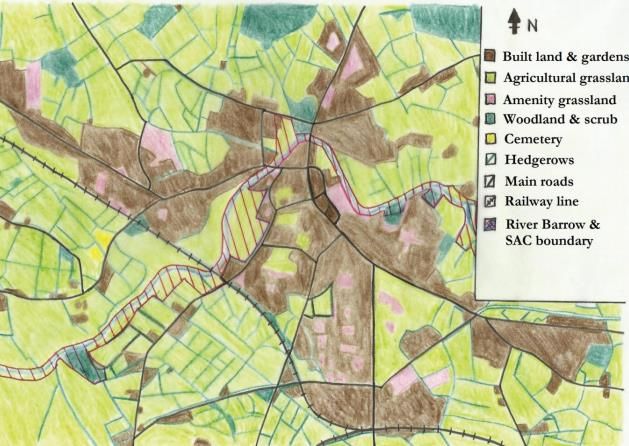
Joint Portarlington Local Area Plan 2018 - 2024

                                                                                                      LIST OF TABLES

Table 1: Population statistics for County Laois and Portarlington...........................................20
Table 2 :Population by age cohort........................................................................................ 21
Table 3: Population by Nationality............................................................................................ . 21
Table 4: Core Strategy Table of Laois County Development Plan 2017-2023...........                                              22
Table 5: Core Strategy Table of Offaly County Development Plan 2014-2020 ............................ 22
Table 6: Live Register Figures, Portarlington, January 2013-18 ................................................... 26
Table 7: Households by accommodation type ............................................................................. 53
Table 8: Households by composition............................................................................................ 54

                                                                                                          LIST OF MAPS

Map 1: Objectives

Map 2: Land Use Zoning Map

Map 3: Land Use & Flooding Map

Map 4: Flood

                                                                 5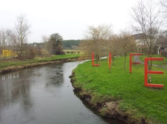
Joint Portarlington Local Area Plan 2018 - 2024

                                                                    1       INTRODUCTION

The National Planning Framework (NPF) includes a National Policy Objective to prepare a joint
local area plan where a town and environs lie within the combined functional area of more than
one Local Authority. The Draft Portarlington Joint Local Area Plan (LAP) has been prepared by
Laois County Council and Offaly County Council in accordance with the requirements and
provisions of the Planning and Development Act 2000, as amended (hereafter referred to as
‘the Act’). The Draft Joint LAP sets out an overall strategy for the proper planning and
sustainable development of Portarlington, in the context of the Laois County Development Plan
2017 – 2023, Offaly County Development Plan 2014 - 2020 and the Midland Regional Planning
Guidelines 2010 – 2022. The Draft Joint LAP has also been informed by Ministerial Guidelines
issued pursuant to Section 28 of the Act together with EU requirements regarding Strategic
Environmental Assessment (SEA) and Appropriate Assessment (AA).

The Draft Joint Local Area Plan comprises a written statement with accompanying maps. The
written statement shall take precedence over the map should any discrepancy arise. In the full
interpretation of all objectives for Portarlington, it is essential that both County Development
Plans (CDPs) and the Local Area Plan (LAP) are read together. Where conflicting objectives arise
between the CDPs and the Draft Joint LAP, the objectives of the relevant CDP shall take
precedence. It should be noted that the general development management standards
applicable to the plan area are included in the relevant CDP, while policies and objectives that
are specific to Portarlington are included in the Draft Joint LAP.

                                               6
Joint Portarlington Local Area Plan 2018 - 2024

                                                   2       LEGISLATIVE REQUIREMENTS

Sections 19 of the Planning and Development Act 2000 (as amended) requires that an LAP be
prepared in respect of an area which –

(i)   Is designated as a town in the most recent census of population, other than a town
      designated as a suburb or environs in that census,
(ii) Has a population in excess of 5,000, and
(iii) Is situated within the functional area of a Planning Authority which is a County Council.

The CSO Census 2016 confirmed that Portarlington has a total population of 8,368 persons. A
LAP is therefore statutorily required for Portarlington.

Section 20 of the Act sets out the process for the making of a Local Area Plan as illustrated in
the follow diagram:

                                      Figure 1: LAP Process

                                               7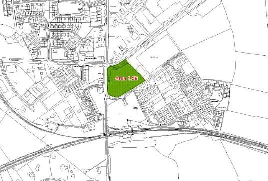
Joint Portarlington Local Area Plan 2018 - 2024

In accordance with Section 19 and 28 of the Act the Draft Joint LAP is subject to the following
environmental considerations:

2.1    STRATEGIC ENVIRONMENTAL ASSESSMENT

Strategic Environmental Assessment (SEA) is required in accordance with the SEA Directive (DIR
2001/42/EC). SEA is a formal, systematic evaluation of the likely significant environmental
effects of implementing a plan, policy or programme. SEA is mandatory for plans for areas with
a population of 5,000 or more and is therefore required for the Draft Portarlington Joint LAP.

Minogue and Associates, Environmental Consultants have been appointed by both Laois and
Offaly County Councils to undertake the SEA as part of the preparation of the Draft Joint LAP. In
this regard, an SEA Environmental Report has been prepared informing the likely environmental
impacts of implementing the policies and objectives of the plan and integrating relevant
environmental considerations into the plan. The SEA Environmental Report accompanies this
Draft Joint LAP. This report sets out the likely environmental consequences of decisions
regarding the location and type of developments within the Plan area, mitigation measures to
offset potential adverse effects of the Plan and monitoring proposals.

2.2    APPROPRIATE ASSESSMENT

Appropriate Assessment (AA) is required in accordance with Article 6(3) and 6(4) of the EU
Habitats Directive (DIR 92/43/EEC). AA is a focused and detailed impact assessment of the
implications of the plan or project, alone and in combination with other plans and projects, on
the integrity of a Natura 2000 site in view of its conservation objectives.

Minogue and Associates, Environmental Consultants have been appointed by both Laois and
Offaly County Councils to undertake Appropriate Assessment as part of the preparation of the
Draft Joint LAP.

Following screening for AA, it was determined that the Draft Portarlington Joint LAP is likely to
have a significant impact on areas designated as a Natura 2000 site, therefore a Natura Impact
Report must be prepared. The mitigation measures identified in the Stage 2 Appropriate
Assessment (Natura Impact Report) have been incorporated into the Plan.

2.3    STRATEGIC FLOOD RISK ASSESSMENT

A Strategic Flood Risk Assessment (SFRA) is required under Section 28 of the Act in accordance
with “The Planning System and Flood Risk Management – Guidelines for Planning Authorities”
as amended by Circular PL2/2014. The primary purpose of the SFRA is to determine flood risk
within a particular geographical area and to support planning decisions in relation to developing
the plan.

                                               8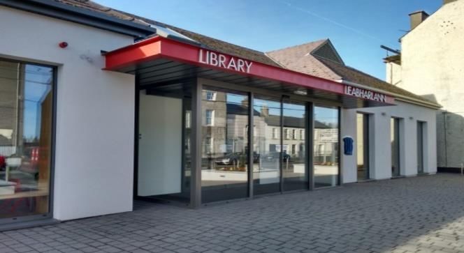
Joint Portarlington Local Area Plan 2018 - 2024

The Strategic Flood Risk Assessment (SFRA) carried out for Portarlington is an assessment of
flood risk in the town to inform strategic land-use decisions with the purpose of ensuring that
flood risk management is fully integrated into the Draft Joint LAP. Arising from the results of the
SFRA, a change in the zoning objectives of some sites is proposed. The SFRA recommends that
development proposals for the areas identified as being at risk of flooding be subject to a site
specific flood risk assessment.

                                                9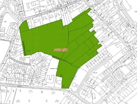
Joint Portarlington Local Area Plan 2018 - 2024
3 OTHER PLANS & GUIDELINES
The Plan has been prepared having regard to national, regional and local policy documents, in
addition to Guidelines issued under Section 28 of the Planning and Development Acts 2000 (as
amended), including the following:
Project Ireland 2040 National Planning Framework (2018)
National Spatial Strategy 2002-2020 (NSS)
Midland Regional Planning Guidelines 2010 - 2022 (2010)
Laois County Development Plan 2017 – 2023
Offaly County Development Plan 2014-2020
Laois Local Economic and Community Plan 2016 – 2021
Offaly Local Economic and Community Plan 2016 – 2021
Local Area Plan Guidelines for Planning Authorities (2013)
Manual for Local Area Plans (2013)
Planning System and Flood Risk Management Guidelines for Planning Authorities (2009)
Our Sustainable Future, A Framework for Sustainable Development for Ireland (2012)
Smarter Travel, A Sustainable Transport Future 2009 - 2020 (2009)
Building on Recovery; Infrastructure and Capital Investment 2016 - 2021 (2014)
Rebuilding Ireland – Action Plan for Housing the Homelessness (2016)
National Climate Change Adaptation Framework; Building Resilience to Climate Change
(2012)
National Energy Efficiency Action Plan 2009 - 2020 (2009)
National Renewable Energy Action Plan (2010)
Government Policy Statement on the Strategic Importance of Transmission and Other
Energy Infrastructure (2012)
Portarlington Strategic Flood Risk Management Strategy 2007
Eastern Catchment Flood Risk Assessment Management Study (CFRAM)
Draft Eastern Flood Risk Management Plans 2016;
Eastern Midlands Region Waste Management Plan 2015-21
Spatial Planning and National Roads Guidelines for Planning Authorities (2012)
National Cycle Policy Framework
Water Services Strategic Plan, A Plan for the Future of Water Services
Water Supply Project Eastern & Midlands Region
Eastern and South Eastern River Basin Management Plan 2009 – 2015
National Broadband Plan 2012
Laois Heritage Plan 2014 - 2019
Draft Offaly Heritage Plan 2017-2021
Framework and Principles for the Protection of the Archaeological Heritage (1999)
Architectural Heritage Protection – Guidelines for Planning Authorities (2011)
Actions for Biodiversity – Ireland’s National Biodiversity Plan 2011-2016 (2011)
10Joint Portarlington Local Area Plan 2018 - 2024
4 PORTARLINGTON IN CONTEXT
The town of Portarlington is situated on the Laois/Offaly county boundary equidistant from the
county towns of Portlaoise and Tullamore. In terms of Local Government, the town has dual
administration by Laois County Council and Offaly County Council. The majority of the urban
area (approximately 75%) is located within the County of Laois (for CSO data purposes, this area
is called Portarlington South) with the remaining portion (Portarlington North) in County Offaly.
The River Barrow flows through the town in a west-east trajectory.
Figure 2: Portarlington in context
Portarlington is designated as a “Key Service Town” in the Midland Regional Planning Guidelines
2010 – 2022 and the settlement hierarchies of both Counties Laois and Offaly. The Key Service
Town functions as a support to the development of the county towns of Tullamore and
Portlaoise.
Due to the town’s proximity to the Greater Dublin Area and its location on the Dublin-Cork/
Dublin-Galway train line, Portarlington has experienced significant population growth since the
beginning of the millennium. In this regard, the town’s population increased from 4,001 persons
in 2002 to 8,368 persons in 2016. Portarlington is ranked third in overall population size in
County Laois and fourth in County Offaly behind the county towns of Portlaoise and Tullamore.
While such population growth has created the critical mass to support the town’s own services
and industry, this growth has in turn placed an even greater demand on the town’s
infrastructure, in particular education, housing, recreational amenities and services.
11Joint Portarlington Local Area Plan 2018 - 2024
5 HISTORY OF PORTARLINGTON
Portarlington was founded in 1666 by Henry Bennett, Lord Arlington on land located on a bend
of the River Barrow. Following the Battle of the Boyne in 1690, the lands containing
Portarlington were given to Marquis de Ruvigney, Earl of Galway who decided to offer the town
as a refuge to the Huguenots, who fled France after the Edict of Nantes in 1685. About 500
Hugenots had arrived by 1702 and in the early 18th century, Portarlington was known as the
“Paris of the Midlands” a place where French, rather than Irish or English, was spoken on its
streets. These new settlers brought a very French style of architecture and life to the town,
building their own church and schools. Some of these Huguenot houses are still to be seen in
the town side by side with fine examples of Georgian, Victorian and modern houses.
Figure 3: Market Square
In the twentieth century, the Portarlington Power station to the north of the town, which
opened in 1950, was Ireland’s first turf fired electricity station using sod peat fuel sourced from
the adjoining Clonasast Bog. At its peak, the station was a significant employer in the area,
consuming approximately 195,000 tonnes of peat per annum, producing 150 million units of
electricity.
Figure 4: Portarlington Power Station 1970
12Joint Portarlington Local Area Plan 2018 - 2024
6 URBAN FORM
The urban form of the town is dominated by a lengthy linear Main Street, terminated by a
Market Square to the north. The development of the town extended in a southerly direction
towards the railway station and the boundary presented by the railway line. Two inner relief
roads from Market Square to Main Street and from Foxcroft Street to French Church Street
removed through traffic from the centre of the town. Spa Street was previously upgraded to
accommodate pedestrians and two-way traffic. Travel time to Dublin was reduced to less than
an hour with the opening of the Heath Mayfield section of motorway in 2004. In this regard,
Junction 15 Monasterevin is located approximately 10 kilometres from the town.
Figure 5: Google Earth Image 5/13/16
The historical core of the town is focused on a zone of archaeological interest centred around
Market Square. The town centre area contains a number of Protected Structures and is
proposed to be designated as an Architectural Conservation Area under the objectives of the
Laois County Development Plan 2017-2023, reflecting its special architectural interest. The Built
Heritage of the town is discussed in further detail in the Built Heritage chapter of this Draft Joint
LAP.
The Dublin/Cork and Dublin/Galway Railway lines comprise the boundaries to the town to the
southwest/west and south. Portarlington is also constrained by the Barrow River and associated
flood plain which forms a loop around much of the town. The issue of flooding is discussed in
further detail in the Flood Management chapter of this Draft Joint LAP.
13Joint Portarlington Local Area Plan 2018 - 2024
7 SPATIAL PLANNING POLICY
The Irish spatial planning hierarchy is set out in the following diagram:
• National Planning
Framework
National
• Regional Spatial &
Economic Strategies
Regional
• Development Plans
• Local Area Plans
Local
Figure 6: Planning Hierarchy
7.1 PROJECT IRELAND 2040 NATIONAL PLANNING FRAMEWORK
“Project Ireland 2040” is the Government’s overarching policy initiative to make Ireland a better
country for all of us, a country that reflects the best of who we are and what we aspire to be.
Project Ireland 2040 is informed by the Programme for a Partnership Government 2016 which
recognizes that economic and social progress go hand in hand, and is made up of the “Project
Ireland 2040 National Planning Framework” (NPF) and the “National Development Plan 2018-
2027” (NPD).
The NPF replaces the National Spatial Strategy (NSS) 2002-2020. The NPF in conjunction with
the NDP is the Government’s plan to cater for the extra one million people that will be living in
14Joint Portarlington Local Area Plan 2018 - 2024
Ireland, the additional two thirds of a million people working in Ireland and the half a million
extra homes needed in Ireland by 2040.
Project Ireland 2040 seeks to achieve ten strategic outcomes, building around the overarching
themes of wellbeing, equality and opportunity. The ten shared National Strategic Outcomes
and Priorities of the National Development Plan will ensure a consistent approach between
planning objectives under the NPF and investment commitments under the NDP. The Ten
Strategic Outcomes and Priorities are:
Figure 7: National Strategic Outcomes
As a strategic development framework “Project Ireland 2040” sets the long-term context for
our country’s physical development and associated progress in economic, social and
environmental terms and in an island, European and Global context. “Project Ireland 2040” will
be followed and underpinned by supporting policies and actions at sectoral, regional and local
levels. This Draft Joint LAP has been prepared with cognizance to these National Strategic
Outcomes.
7.2 REGIONAL PLANNING GUIDELINES FOR MIDLAND REGION 2010 – 2022
The Midland Regional Planning Guidelines (MRPGs) 2010-2022 were prepared under the
National Spatial Strategy and designated Portarlington as a Key Service Town. The MRPGs
identify five development areas, with Portarlington located within the Eastern Development
15Joint Portarlington Local Area Plan 2018 - 2024
Area (EDA) of the Midlands Region which is situated on the border with the Greater Dublin
Area. The role of Portarlington in the MRPGs correlates to the role designated to the town in
the Laois County Development Plan 2017-2023 and Offaly County Development Plan 2014-
2020.
Figure 8: Portarlington in the context of the Midlands Region
Key service towns act as important drivers for local economies in areas that are comparatively
more remote from the main population centres of the region. Well established economic,
administrative, and social functions are provided in these settlements at levels commensurate
with their position on the urban hierarchy. The MRPGs envisage that the development of these
towns will be closely linked with the development of the principal towns.
The Core Strategy in accordance with the provisions of the Act requires the correlation of the
population targets of the MRPGs with housing land requirements of the settlement hierarchy.
The Core Strategy is set out under Section 2 of the Laois County Development Plan 2017 - 2023
and under Chapter 1 of the Offaly County Development Plan 2014 – 2020.
16Joint Portarlington Local Area Plan 2018 - 2024
The MRPGs state that there is potential for growth in employment generation in this area due
to the workforce availability. A key priority should be to resist any further large-scale residential
development and to avoid over-development of these towns. The provision of necessary social
and community infrastructure to serve resident populations should be a priority.
7.3 REGIONAL SPATIAL AND ECONOMIC STRATEGY
Since the Midland Regional Planning Guidelines (MRPGs) were published in 2010, a new
administrative structure at regional level has been developed as directed by the Local
Government Reform Act 2014. The Reform Act included the abolition of eight Regional
Authorities and the creation of three Regional Assemblies. County Laois now forms part of the
Eastern and Midland Regional Assembly (EMRA) along with eleven other counties. This area
further comprises three Strategic Planning Areas with Offaly, Laois, Westmeath and Longford
forming part of the Midland Strategic Planning Area. The EMRA will be responsible for the
preparation of a new Regional Spatial and Economic Strategy (RSES) which will replace the
RPGs.
The RSES will identify the Eastern and Midland region’s key strategic assets, opportunities and
challenges and set out policy responses to ensure that peoples’ needs – such as access to
housing, jobs, ease of travel and overall well-being are met, up to 2030 and beyond. In this
regard, the RSES will set a new regional context to guide and control the development of
Counties Laois and Offaly.
The RSES will include:
A Spatial Strategy for the future location of employment, housing and retail development
along with supporting infrastructure and services, in a way that enhances the potential of
our cities and towns and best protects our environment and our people from the impacts
of climate change;
An Economic Strategy with strategic policies to boost competitiveness and support a
strong future economy and the creation of high-quality jobs for sustained prosperity;
A Dublin Metropolitan Area Strategic Plan (MASP) to plan for the future sustainable
growth of the capital city region as set out in the National Planning Framework.
On publication of the RSES, both Laois County Council and Offaly County Council will undertake a review
of the LAP, as necessary, in order to update and ensure compliance with the strategic approach adopted
therein. In the interim the Draft Joint LAP has been prepared in consistency with the existing MRPGs as
outlined above.
17Joint Portarlington Local Area Plan 2018 - 2024
8 DEVELOPMENT VISION & STRATEGY
The Draft Portarlington Joint Local Area Plan is underpinned by a strategic vision which is
intended to guide the future growth of the town. The objectives outlined below combine to
form a coherent development strategy to 2024 and beyond. These goals cover economic, social
and environmental dimensions. The strategic vision recognises the potential of Portarlington to
align with the key growth objectives set out in higher order spatial plans and to take advantage
of the strategic location of the town both regionally and nationally. Delivering on these
objectives will result in an enhanced quality of life for all citizens.
The strategic vision is based on the role of Portarlington as defined in the settlement strategies
of the Laois County Development Plan 2017 – 2023 and Offaly County Development Plan 2014 -
2020 and the aspirations of the people and stakeholders in Portarlington. The vision statement
reads as follows:
“To develop Portarlington as a sustainable low carbon settlement centred on a vibrant town
centre, utilising the location strengths to attract employment and promote the unique
settlement as an attractive town in which to work, live and play, while ensuring the protection
of the unique built and natural heritage and managing flood risk”.
Portarlington will become a place for its people, where residents, workers and visitors alike will
come to enjoy a place that is inclusive, accessible and sustainable from a social, economic and
environmental perspective. The Draft Joint LAP and overall vision for Portarlington is
underpinned by a number of interlinked strategic aims as illustrated in the diagram below.
These interlinked strategic aims will be realised through the chapters of the plan.
Figure 9: Strategic Aims
18Joint Portarlington Local Area Plan 2018 - 2024
8.1 KEY PLAN OBJECTIVES
This Draft Joint Local Area Plan is based on a number of general goals which are designed to
improve the quality of life of the citizens of the town and surrounding hinterland and which the
council will endeavour to implement during the period of the Plan. The development of
Portarlington over the lifetime of this plan shall be focused on employment generation, the
consolidation of the town centre and the provision of community and social services.
The following are specific objectives in relation to the delivery of the Strategy:
1. To support and facilitate sustainable intensification and consolidation of the town centre
and in established residential areas;
2. To promote and support balanced economic development and employment ensuring a
diverse range of economic sectors are developed and supported;
3. To support and facilitate development on zoned land based on the policies and
objectives of the Laois County Development Plan 2017-2023;
4. To focus new residential development primarily into brownfield, infill and backland sites;
5. To protect, conserve and enhance the built, natural and cultural environment, through
promoting awareness, utilising relevant heritage legislation and promoting good quality
urban design;
6. To develop and improve flood alleviation measures throughout the town and rural
hinterland;
7. To require the preparation and assessment of all planning applications in the plan area
to have regard to the information, data and requirements of the Appropriate
Assessment Natura Impact Report, SEA Environmental Report and Strategic Flood Risk
Assessment Report that accompany this Draft Joint LAP;
8. To require projects to be fully informed by ecological and environmental constraints at
the earliest stage of project planning and any necessary assessment to be undertaken,
including assessments of disturbance to habitats and species, where required.
On the basis of the above it is the key policy of the Council to:
1. Implement the development strategies for Portarlington in order to be consistent with,
and in accordance with policies of higher tier plans;
19Joint Portarlington Local Area Plan 2018 - 2024
2. Support strategic enterprise and employment opportunities at appropriate locations in
Portarlington, having regard to proper planning and sustainable development and
relevant development control standards;
3. Facilitate and promote Portarlington’s role as a “Key Service Town” as designated in the
MRPGs, the Laois County Development Plan 2017-2023 and the Offaly County
Development Plan 2014-2020;
4. Monitor and manage the delivery of population and housing in Portarlington, in line
with national, regional and county level objectives, through the development strategy in
this plan and also through the development management process;
5. Facilitate and support the provision of new, and expansion of existing, services, facilities
and community infrastructure.
8.2 CORE STRATEGY
The Core Strategy for County Laois is set out under Section 2 of the Laois County Development
Plan 2017 – 2023 and for County Offaly under Chapter 1 of the Offaly County Development Plan
2014 - 2020. Section 19 (2) of the Act requires that:
“A Local Area Plan shall be consistent with the objectives of the Development Plan, its Core
Strategy, and any Regional Spatial and Economic Strategy that apply to the area of the plan...”
8.3 FUNCTION, POPULATION AND SCALE OF PORTARLINGTON
The Midland Regional Planning Guidelines and the Core Strategies of the Laois County
Development Plan 2017 – 2023 and the Offaly County Development Plan 2014 - 2020,
designate Portarlington as a Key Service Town within the settlement hierarchy. These towns
perform important retail, residential, service and amenity functions for local rural hinterlands
and support the upper tiers of the urban hierarchy including the county towns.
Persons 2002 Persons 2006 Persons 2011 Persons 2016 %Change 06-16
Co. Laois 58,774 67,059 80,559 84,697 26.3
Co. Offaly 63,663 70,868 76,687 77,868 9.9
Portarlington 4,001 6,004 7,788 8,368 39
Table 1: Population statistics for County Laois and Portarlington between 2002 and 2016 (Source: CSO)
20Joint Portarlington Local Area Plan 2018 - 2024
As can be seen in the table above County Laois has experienced significant population growth in
the past decade, growing by 26.3% over the ten year period between 2006 and 2016, while
County Offaly experienced more modest population growth of 9.9%. In the same ten year
period, Portarlington experienced a population growth rate of 39%.
The chart below presents a breakdown of the age of the population of Portarlington.
Portarlington benefits from a young population, with 53% of the population below 35 years of
age, compared to 47.1% elsewhere in the State. Portarlington has a lower proportion of middle-
aged and older residents, with just 16% of the population aged 55 or older, compared to 24%
elsewhere in the State.
Table 2: Population by age cohort Table 3: Population by Nationality
(Source: CSO Census 2016) (Source: CSO Census 2016)
Portarlington also benefits from ethnic diversity with 14% of its population being non-Irish. Of
particular note, is that almost 12% of the population is made up of EU nationals excluding the
UK.
Population targets for both Counties Laois and Offaly and for Portarlington for the period up to
2022 are set out within the MRPGs. Owing to significant and sustained population growth in
County Laois, particularly in Portlaoise, these population targets have been exceeded and
revised targets have been agreed as part of the CDP. These revised targets provide for growth
to 89,790 persons in County Laois by 2023 and for growth to 8,567 persons in Portarlington
South (Laois) over the same plan period. For Portarlington South (Laois), this equates to a
projected requirement for an additional 271 households over the six-year period up to 2023.
Meanwhile, 5 hectares of residential land has been allocated to facilitate the growth of
Portarlington North in the Core Strategy of the Offaly County Development Plan 2014-2020
which equates to an additional 174 persons.
21Joint Portarlington Local Area Plan 2018 - 2024
County Laois Portarlington
CSO Population 2011 80,559 7,788
Projected Population 2023 89,790 8,567
Projected Increase 9,231 779
Projected Increase in Households 2023 3,216 271
Density (Per ha.) 12
Housing Land Requirement to 2023 34
(Including 50% headroom)
Area (ha.) zoned for Residential 34
Table 4: Core Strategy Table of Laois County Development Plan 2017-2023
County Offaly Portarlington
CSO Population 2011 76,687 1,678
Population increase plan period 89,790 8,567
Housing land allocation to 2020³ (inc. 9,231 5
50% head room)
Table 5: Core Strategy Table of Offaly County Development Plan 2014-2020
³This figure was reached for each settlement by apportioning the projected population growth
by applying a growth rate and density based on each settlements place on the hierarchy and an
average household size of 2.9 people.
As can be seen from the Core Strategy Tables above, the CDPs identify an accumulative
requirement for 39ha. of land in order to accommodate planned residential growth, with an
average density of 12 units per hectare.
8.4 RESIDENTIAL LAND AVAILABILITY
The Draft Joint LAP identifies approximately 35.6 ha. of undeveloped residentially zoned land,
located within and adjacent to established residential areas within the town. The housing
capacity of these lands and infill sites within the built-up area is estimated to be approximately
427 (35.6 ha. x 12 units per ha.) residential units, based on a density of 12 units per hectare.
Over the lifetime of the Draft Joint LAP, priority for residential development should be given to
the development of these lands to consolidate the built up area of the town.
8.5 FUTURE DEVELOPMENT PRIORITIES
8.5.1 TOWN CENTRE CONSOLIDATION
The Draft Joint Local Area Plan has been prepared in the context of a longer term vision for
Portarlington. The Draft Joint LAP identifies eight opportunity sites to accommodate growth
during the plan period. Site specific details for each site are set out under the Town Centre
Revitalisation chapter. A sequential approach will be taken to the development of the town,
with lands closer to the town centre being developed prior to zoned lands on the periphery so
22Joint Portarlington Local Area Plan 2018 - 2024
as to avoid “leapfrogging”. With this in mind, the zoning of the significant landbank to the north
of Patrick’s Street on the Offaly side of the town has changed from “Town Centre/Mixed” in the
previous plan to “Residential 2” in this plan which encourages the consolidation of the existing
town centre. Such an approach is essential to underpin the sustainable delivery of population
and employment development and consolidation of the town centre over the plan period.
Consolidation, brownfield and infill development will also be promoted on appropriately zoned
land within the plan area which accords with the policies and objectives set down in this plan.
8.5.2 ECONOMIC DEVELOPMENT
Economic development underpins all chapters in this Draft Joint Local Area Plan. The aim of the
plan is to capitalise on Portarlington’s location on the regional road network, trainline and
proximity to the motorway interchange at Monasterevin. The zoning and servicing of land for
enterprise, employment and industrial uses and in particular the development at Portarlington
Enterprise Centre and Botley Lane represent an important opportunity to develop a cluster of
complementary enterprises and more generally a larger, more robust and diverse economic
basis for the town.
8.5.3 KEY INFRASTRUCTURE
Future development proposals are contingent on key infrastructure. Currently capacity exists in
the Foul Sewer Network, Waste Water Treatment Plant and Public Water Supply. In the long
term it is an objective of the Council to facilitate public transport improvements and provide a
town relief road to help alleviate traffic congestion in the town centre and at the pinch point on
Barrow Bridge and at Kilmalogue Crossroads.
8.5.4 ENVIRONMENT AND HERITAGE PROTECTION
The environmental sensitivities of the county identified in the SEA process for the Laois County
Development Plan 2017-2023 and the Offaly County Development Plan 2014-2020 have
informed the Core Strategy and the role it identifies for Portarlington. The Draft Joint LAP
responds to environmental factors, including wastewater infrastructure constraints, areas at
risk of flooding etc. It also acknowledges the importance of built and natural heritage, such as
that at Derryounce as an environmental and economic (including tourism) resource and
includes significant objectives for its conservation and enhancement.
8.5.5 COMMUNITY FACILITIES
There is an existing vibrant community and voluntary sector in Portarlington and the demand
for community services, education and recreational amenities has increased with the growth in
population. This plan will seek to facilitate, wherever possible, the provision of new, and
expansion of existing, services, facilities and community infrastructure including extension of
childcare facilities, the Community Centre car park and Leisure Centre.
23Joint Portarlington Local Area Plan 2018 - 2024
9 ECONOMIC DEVELOPMENT
Portarlington is a busy Key Service Town with a retail area centred on the Main Street and
enterprise and industrial uses located at more peripheral locations. Capacity exists within the
town for a greater retail offering and to develop small and medium enterprises in existing
enterprise estates/Business Parks. Both Councils are committed to facilitating the creation of
employment within the town and this plan provides the appropriate framework for development
through the provision of adequately zoned lands and policies which support economic
development. The zoning objectives for each of the land-use zones provide agility to respond to
the demands from those looking to invest in Portarlington. This plan sets the right conditions to
secure inward investment and interest in Portarlington as a business location and firmly embeds
an economic development agenda into all other goals making their successful delivery more
achievable.
The Laois County Development Plan 2017-2023 and Offaly County Development Plan 2014-
2020 set out the strategic context for economic development of the Counties. The Laois Local
Economic and Community Plan (LECP) 2016-2021 and Offaly Local Economic and Community
Plan (LECP) 2016-2021 are statutory plans which aim to promote the economic and community
development of the counties. Both LECPs should be read in tandem with this chapter.
The Local Enterprise Offices have been fully integrated into both the Local Authorities of Laois
and Offaly. In addition to the LEO enterprise functions, the LEOs deliver the economic functions
of the Councils and have a lead role in implementing the economic dimensions of the LECPs and
delivering local and regional initiatives within the Midland Action Plan for Jobs. The LEOs
provide a range of services for persons seeking to set up or grow a business. The LEOs work
with a range of stakeholders to support employment opportunities including the Department of
Jobs, Enterprise and Innovation, the IDA, Enterprise Ireland, local and regional development
agencies, existing businesses and individuals.
The services provided by LEO allow for a broader and deeper approach to job creation through
opportunities presented by the not so traditional sectors for example green economy, tourism,
creative services /industries and cloud computing. Both LEOs contribute significantly to building
pathways to employment and enterprise in Portarlington by:
• Facilitating client meetings through an Outreach Office (held in the Portarlington
Enterprise Centre once a week);
24Joint Portarlington Local Area Plan 2018 - 2024
• Providing high quality, integrated information and support to new and expanding
businesses;
• Providing training, mentoring and support;
• Enabling access to start-up finance;
• Collation and quarterly update of a Property Database for all industrial, commercial and
retail premises that are for sale or let in the town, enabling business owners to research
and identify suitable property;
• Collaborating with Portarlington Library Services on Library Supports for business
schemes;
• Working with schools to introduce young people to the potential of working in business
and promoting an enterprise culture.
Laois Partnership Company was formed in 2008 to offer one unified structure for the delivery
of economic, social and cultural services to small businesses, community groups and
individuals. This work is largely delivered through initiatives including The Rural Development
Programme (previously LEADER), Social Inclusion Community Activation Programme (SICAP),
DSP Job Club, Community Employment Schemes, Tus Programme, Rural Social Scheme, Services
to the Elderly Programme (LSTEP), National Childcare Schemes, Back to Education Initiative, the
Local Community Development Programme (previously LDSIP) and other complementary
programmes.
The Portarlington Community Development Association (PCDA) is a voluntary group which
aims to develop all aspects of the town. The PCDA set up the Portarlington Enterprise Centre
(PEC) which is a not for profit business with a key focus on fostering business and employment
opportunities for the local community. The PEC provides a range of facilities including office
and light industrial units, meeting/ training rooms, business mentoring, access to high speed
broadband, training, advice and supports. An Art Technology and Design Hub including a
FabLab and hot desking facilities will be opened in the PEC during 2018.
An established measure of the employment “health” of a settlement is a measure called the
“Jobs Ratio”. This is the relationship between the number of people in the labour force and the
number of jobs in any defined area. A healthy area is considered to be one where the jobs ratio
is around 70%. While not all towns will be able to reach this level, it is considered reasonable
that the plan should aim to increase the jobs ratio proportionately to accord with the town’s
characteristics and level in the County settlement and employment hierarchy.
As indicated in Census 2016 Portarlington has a total labour force of 3,798 persons.
The census also indicates that there are 1,349 jobs within the settlement of Portarlington.
Given an indicated resident worker population of 3,103, Portarlington has a jobs to resident
workers ratio of 0.435.
The majority of persons commute to work, school or college by car (2,038 persons) and have a
commute of under 15 minutes (1,809 persons), while 898 persons have a commute of over
1/1.5 hours.
25Joint Portarlington Local Area Plan 2018 - 2024
According to the Census 2016, commerce, trade and professional services account for 46% of
the overall employment in Portarlington, continuing the significant shift from the previous
dependence on construction and manufacturing which were the pre-eminent sources of
employment in the town in the late 1990s and early to mid-2000s.
The proportion of the population aged 15 years and over in Portarlington that described
themselves as “at work” increased from 47.35% in the 2011 Census to 51.37% in the 2016
Census, reflecting somewhat the national economic recovery in recent years. However,
employment levels in the Portarlington labour force are below that of the rest of the State, with
51% of residents in employment, compared to 54% nationally. However, the proportion of the
labour force either unemployed or seeking their first regular job at 12% is significantly higher
than the national rate of 8%. Live Register figures for the town show a consistent reduction in
the number on the register from January 2013 to January 2018.
Figure 10: Labour Force by Principle Economic Status (Source: Census 2016)
January 2018 1,753
January 2017 1,971
January 2016 2,427
January 2015 2,865
January 2014 3,214
January 2013 3,373
Table 6: Live Register Figures, Portarlington, January 2013-18 (Source: CSO)
The creation of sufficient employment opportunities in Portarlington is fundamental to build a
sustainable community and reduce the rate of outward commuting. Portarlington’s unique
location on the regional road network, intersection of the national train line and proximity to
the Greater Dublin Area, in conjunction with the zoning and servicing of cost effective land and
good quality high speed broadband is of major benefit to attracting economic development to
the town.
26Joint Portarlington Local Area Plan 2018 - 2024
This plan places a firm emphasis on maintaining and expanding existing businesses such as
Odlums, Jamestown, Camsaw, Polar Ice etc., small businesses, entrepreneurial development
and tourism, rather than a return to reliance on construction and industry as the drivers of the
local economy. Additionally, building strong communities, improving the physical environments
namely the town centre and developing or marketing a strong identity for the town can do
much to attract new businesses and investment. In this respect, the Council will support local
enterprise and employment generating opportunities, facilitate the up skilling and training of
the labour force and the provision of key hard and soft infrastructure. Such measures aim to
create an attractive base for employers and more self-sustaining development for the
population, while providing an alternative to commuting to the GDA for employment.
Tourism in Portarlington has the potential to play a significant role in economic development.
The Laois Tourism Strategic Plan 2018 – 2023 identifies Portarlington as one of four potential
towns to pilot a “Laois Towns Experience” programme, based on the heritage and stories
associated with the French Huguenots that settled in the town in the 17 th Century. In addition,
the town has a wide variety of attractions both within the town and environs which have the
potential to be developed as tourist attractions in their own right, while providing additional
spin off benefits to existing businesses in the town. Some of the attractions which provide a
basis for a tourism industry include the development of walking, cycling and angling pursuits on
the River Barrow, the Derryounce Experience comprising the recreational area at the
Derryounce Lakes and Trails accessed directly from the town and the golf and leisure activities
available at the nearby Heritage Resort at Killenard.
Economic Development: Strategic Aim:
To promote, facilitate and enable economic development and employment generating
activities in appropriate locations and in a sustainable manner.
Objectives: It is an Objective of both Laois and Offaly County Council to:
EEO1: Support the work of the Local Enterprise Offices in performing their functions of
facilitating enterprise and economic development, delivering local and regional
initiatives through the Laois Local Economic and Community Plan 2016-2021, Offaly
Local Economic and Community Plan 2016-2021 and the Midland Action Plan for Jobs
and working with key national, regional, local, public and private stakeholders to
support employment opportunities in Portarlington;
EEO2: Co-operate with Portarlington Community Development Association, IDA Ireland,
Enterprise Ireland, the Laois Partnership Company and other agencies, organisation
and individuals in promoting enterprise and employment in Portarlington;
EEO3: Identify infrastructural and service deficits experienced by existing businesses, and
work towards addressing these deficits;
27Joint Portarlington Local Area Plan 2018 - 2024
EEO4: Promote existing space available in the town for the establishment of incubator units
and start-ups;
EE05: Facilitate the development of employment generating enterprises within existing
employment areas such as the town centre, Botley Lane, Portarlington Enterprise
Centre and vacant commercial premises such as Avon;
EE06: Promote and encourage cultural development and creative industries;
EE07: Promote and market Portarlington as a strong and competitive alternative location for
business by highlighting distinctive attributes and characteristics;
EEO8: Ensure that buildings proposed in the Laois Business Park and Botley Lane in the
future are of a high quality design;
EEO9: Facilitate the development of the Derryounce Experience Lakes and Trails;
EEO10: Facilitate development of an historical trail through Derryounce Bog and a Heritage
Museum documenting the history of the bog, turf production in the area and the
former location of the town’s Power Station;
EEO11: Facilitate development of a green corridor connecting Derryounce Lakes and Trails, the
River Barrow and The Peoples Park;
EEO12: Support the development of a cycleway from Derryounce Lakes and Trails to Mount
Lucas;
EEO13: Support the provision of maps and signage for tourist facilities at locations at
Portarlington Railway Station, Market Square, Main Street, Patrick Street, River
Barrow, Peoples Park and Derryounce Lakes and Trails;
EEO14: Support the continued operation and reasonable development of existing non-
conforming uses provided that such uses do not:
Result in a loss of amenity to adjoining properties;
Cause an adverse impact on the environment;
Cause an adverse impact on the visual amenity or character of the area;
Inhibit the development of adjoining land in conformance with the land’s zoning
objective.
28Joint Portarlington Local Area Plan 2018 - 2024
Policies: It is the Policy of both Laois and Offaly County Council to:
EEP1: Support sustainable employment and enterprise in Portarlington through the
identification of appropriately located and adequately serviced lands for
business/employment, industrial and commercial developments, the promotion of
investment in transportation and other support infrastructure and the creation of a
high quality environment to encourage economic investment;
EEP2: Protect employment zoned land from inappropriate development that would
undermine future economic activity or the sustainable economic development and
growth of the town;
EEP3: Facilitate employment and enterprise development in the context of the role of
Portarlington as a Key Service Town consistent with objectives of the core strategy
set out in the Laois County Development Plan 2017-23 and the Offaly County
Development Plan 2014-2020;
EEP4: Encourage appropriate development, works and supporting infrastructure that would
contribute to a high quality and attractive built and social environment in Portarlington
to attract and sustain new business, residents and visitors;
EEP5: Encourage the establishment and expansion of services and facilities in the town at
appropriate locations to facilitate the business needs of employment and enterprise
developments and potential tourism needs like conference facilities, hotel,
accommodation, eateries and other similar services;
EEP6: Work collaboratively and in partnership with other stakeholders in the pursuit of
development that would contribute positively to the economic development of the
town;
EEP7: Support and work with Bord Na Mona and other relevant agencies in the sustainable
diversification of former industrial peatlands in the Garryhinch area to uses such as
green energy, eco-tourism and water storage;
EEP8: Encourage the further development of the Portarlington third level institute as a
centre of excellence for a range of education and research related uses;
EEP9: Work in conjunction with the town’s third level institution and neighbouring
institutions including NUI Maynooth and Athlone and Carlow ITs in the creation and
fostering of enterprise and research and development;
EEP10: Facilitate office development in commercial and employment centres;
EEP11: Continue to work with key stakeholders in the tourism industry including Waterways
29You can also read