Alton - Neighbourhood Development Plan 2011 to 2028 As modified April 2021 Alton Town Council, Town Hall, Market Square, Alton, Hampshire, GU34 1HD
←
→
Page content transcription
If your browser does not render page correctly, please read the page content below
Alton

Neighbourhood Development Plan
                   2011 to 2028
          As modified April 2021

Alton Town Council, Town Hall, Market Square, Alton, Hampshire, GU34 1HD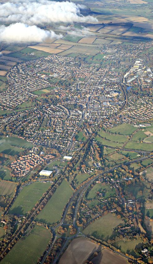
2 Alton Neighbourhood Development Plan
Foreword

            ALTON TOWN MAYOR
            Town Hall
            Market Square
            Alton
            Hampshire
            GU34 1HD    Telephone 01420 83986             Email info@alton.gov.uk

                  Dear Fellow Altonians,

                  It is my honour to write this introduction to the updated version of the Alton
                  Neighbourhood Plan. The previous version was adopted in a referendum in 2016 by a
                  massive majority of Altonians. Since then its policies have benefitted us by giving us
                  an increased influence on the decisions that affect the development of our town.
                  However development and planning do not stand still and we are required to keep it
                  up to date if it is to continue to “carry weight” in planning decisions. In particular, the
                  government requires us to maintain an adequate supply of land for new housing.
                  Alton Town Council thoroughly considered the options regarding the Neighbourhood
                  Plan. East Hampshire District Council is working on a new Local Plan that will,
                  amongst other issues, address how the longer-term housing needs of the area are to be
                  met. The government has said that it plans to make major changes to the planning
                  process, including the role of Neighbourhood Plans. In the light of these two factors,
                  your council did not feel it was appropriate to produce a completely new plan at this
                  time. The policies and aspirations in the existing plan remain relevant and are
                  ongoing. Instead we resolved to update the housing supply policies to reflect the
                  changes that have occurred since the plan was adopted. These result from the two
                  town centre sites that have become redundant from their former use, and the
                  development that has been completed on the newer housing sites. This new updated
                  version of our Neighbourhood Plan will allow us to retain a say in the future of our
                  town and to resist unwanted speculative development.

                  Despite the limited scope of the modifications, the production of this plan has
                  required a substantial amount of work from several people, most of whom have been
                  working in a voluntary capacity. They are acknowledged at the end of this document.
                  I would like to thank everyone for their tireless and public-spirited work. I would also
                  like to thank everyone who has responded to our public consultation. Your comments
                  have been noted and your support has enabled us to move forward in the confidence
                  that this Plan reflects the desires of most Altonians.

                  Yours sincerely
                  Councillor Graham Titterington

Alton Neighbourhood Development Plan                                                                            3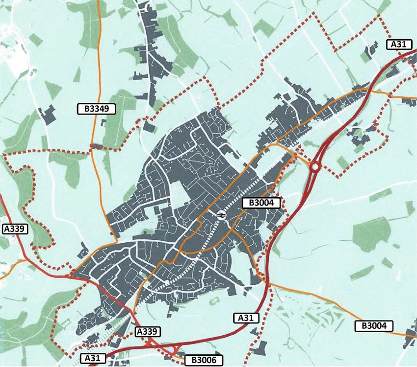
Foreword

    This Neighbourhood Development Plan has been written in response to a requirement
    for Alton to accept significant development over the years 2011 to 2028. It is a natural
    progression from the Alton 2020 Town Plan published in 2005 and other follow on work
    such as the Town Design Statement, all of which demanded significant amounts of public
    consultation and feedback. The response from the public for this plan has been excellent
    and the Neighbourhood Plan Steering Group (NPSG) has worked hard to capture all
    feedback as evidence to support legally enforceable policies in the Plan.

    Altonians really care about their town and want it to retain its
    charm, character and setting into the future whilst accepting
    that development must happen. Alton 2020 recognised that
    Alton needed to grow to become more sustainable.
    I believe that this Plan, where sometimes hard decisions
    have had to be taken, has ensured that Altonians continue
    to play a significant part in how the town evolves into the
    future. I thank the NPSG who have, on a voluntary basis,
    given up significant amounts of their spare time to pursue
    implementation of this Plan over a period of almost
    24 months and the public for their support.
                                                                       Mike Heelis MBE, Chair of
    2021 : I am delighted with the continued utility of this           the Alton Neighbourhood
    Neighbourhood Development Plan (NDP) since its                     Plan Steering Group
    endorsement and publication in 2016. Alton Town Council
    (ATC) and East Hants District Council (EHDC) have embraced
    the Policies and Action Points to the benefit of the town and
    its surrounding settlements. Inevitably plans go out of date
    as they age and updates are required, this being the situation
    ATC finds itself in with this NDP. So I commend them for
    taking the initiative to carry out work to produce the modified
    Plan as an interim measure, this being before a full review of
    the NDP after a new EHDC Local Plan is published.
    A lot of work has been undertaken by the modified ANP
    Steering Group, Councillors and Officers, with considerable
    support from EHDC. The public have been formally consulted
    and their opinions listened to on all changes. The demand for
    development to meet Government quotas is therefore being
    met, to ensure the best possible outcome for the town and
    its evolution.

4                                                           Alton Neighbourhood Development Plan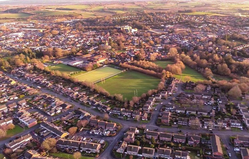
Contents

                                                         Page

         1. Introduction                                   6

         2. Local planning context                         7

         3. Plan development                               9

         4. Overview of Alton                             10

         5. Plan scope and objectives                     13

         6. Plan policies                                 15
                Design                                    17
                Housing                                   23
                Transport                                 42
                Community, health and recreation			       59
                Education                                 79
                Economic sustainability and viability     83

         7. Going forward                                 90

         Acknowledgements                                 91

Alton Neighbourhood Development Plan                            5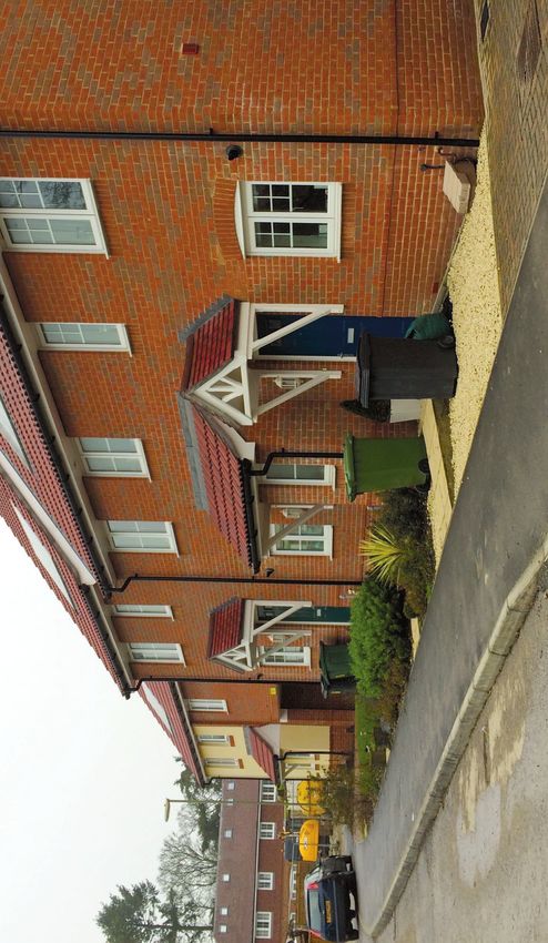
1. Introduction

     This Neighbourhood Development Plan has been created by Alton Town Council in
     Hampshire in order to shape the town’s growth up to 2028. It has been written to become
     a part of East Hampshire District Council’s (EHDC’s) statutory Development Plan (the
     plan for the whole district) and it sets out a range of non-strategic policies which will guide
     planning decisions made by the local planning authority in respect of Alton. It therefore
     covers the same period of time as the statutory Development Plan, which is 2011 to 2028.

     The Neighbourhood Development Plan makes use of powers that were brought about by
     the Localism Act 2011 and its subsequent regulations. They name town and parish councils
     as ‘qualifying bodies’ which may produce a Plan for their area. The intention is to ensure
     that Alton residents have a greater say than they otherwise would have in the way that the
     area grows and changes. There is a desire to see development which reflects the needs of
     local people and brings benefit to the town.

     This document therefore takes heed of local people’s views, as expressed through various
     means of consultation and engagement, as well as taking account of evidence about needs,
     existing policies in the East Hampshire Local Plan: Joint Core Strategy, and the National
     Planning Policy Framework, with its emphasis on sustainable development (the latter
     including its sister document, the National Planning Practice Guidance).

     The remainder of this document:

     •   Provides information about the local planning context;
     •   Gives an overview of Alton;
     •   Outlines the Plan’s scope and objectives;
     •   Sets out each of the Plan policies and linked action points;
     •   Comments on future monitoring and implementation work.

     The modification process has sought to review and update the residential allocations.
     The site allocation process was agreed with EHDC and is summarised as follows:

     • Identify sites within the Neighbourhood Plan Designated Area through EHDC,
       from latest land availability assessment (LAA, December 2018) and sites subsequently
       promoted or identified through the emerging Local Plan process
     • Undertake an initial short-listing of sites to discount those which are promoted for
       non-residential uses or which lie outside the Settlement Boundary Policy or which are
       not made available for the Neighbourhood Plan review
     • Subject the ten shortlisted LAA sites at Alton to preference criteria including:
       - Consistency with Neighbourhood Plan policies and objectives
       - Environmental and Heritage constraints
       - Other site constraints e.g. contamination / noise / topography / access
       - Planning history
     • Review the existing Neighbourhood Plan allocation sites to determine if a change is
       required to the allocation.

6                                                             Alton Neighbourhood Development Plan
2. Local planning context

         East Hampshire Local Plan Joint Core Strategy
         The Local Plan: Joint Core Strategy was produced by EHDC and the South Downs National
         Park Authority. The document, which sets out its policies, was formally adopted in May and
         June 2014 following its successful examination in public. Therefore an up to date Local Plan
         with strategic policies covering Alton is in existence.

         In total there is an expectation that 1,731 new dwellings will be built at Alton between
         2011 and 2028. 1,031 of these already have planning permission to be built or are on sites
         that were previously allocated for development or are expected windfall sites.
         The Joint Core Strategy (2014) cites Alton as a location which is relatively well suited to take
         sustainable development (policy CP2). It makes a housing allocation of 700 (minimum) new
         dwellings at Alton over the period from 2011 to 2028 (policy CP10). The examination of
         that Strategy noted a shortage of available brownfield sites within the built up area and that
         development would therefore probably be on edge of town greenfield sites.

         1,731 dwellings represents a major expansion of the town. In 2013 an Alton Study was
         conducted by consultants commissioned by EHDC. It took a long-term view of the town,
         beyond this plan period, and concluded that this level of development could be sustainable
         if local constraints were managed.

         This Neighbourhood Development Plan includes allocations already made by EHDC, and
         identifies appropriate allocation sites for the 700 (minimum) new dwellings, all of them
         being sites which have come forward as a result of the District Council’s Strategic Housing
         Land Availability Assessment (SHLAA) process.
         This process:

         • Called for available development sites, the most recent call being that run in
           summer 2014;
         • Undertook an initial short listing of the available sites to discount those which were
           clearly inappropriate e.g. unsustainable;
         • Subjected the thirteen shortlisted SHLAA sites at Alton to a full Sustainability
           Assessment, this being conducted by external consultants to consider their
           environmental, social and economic pros and cons on a comparable basis.

         That formed a key input to the Neighbourhood Development Plan, which considered
         the thirteen SHLAA sites. Further relevant evidence about sites was contained in the
         Landscape Capacity Study which was published by the District Council in 2013. However,
         where applicable, the number of likely dwellings shown for each site is based on the latest
         planning decisions available.

         Hampshire County Council, as the Local Highways Authority with financial support from
         the District Council, has been undertaking an Alton Strategic Transport Study (published in
         June 2015), which was instigated as a result of the town’s Neighbourhood Development
         Plan work. This has been considering strategic transport needs, given the expected overall
         housing growth, as well as providing additional evidence in the form of traffic counts and
         forecasts for potential development sites and new highway infrastructure.

Alton Neighbourhood Development Plan                                                                        7
2. Local planning context
Designated area
The designated Neighbourhood Development Plan area is all of the Town Council area
except for a small strip of uninhabited farm land at the southern tip, which falls within the
South Downs National Park. This designation was formally agreed by the local planning
authority (EHDC) on 8th May 2014 in line with the Neighbourhood Planning (General)
Regulations 2012.
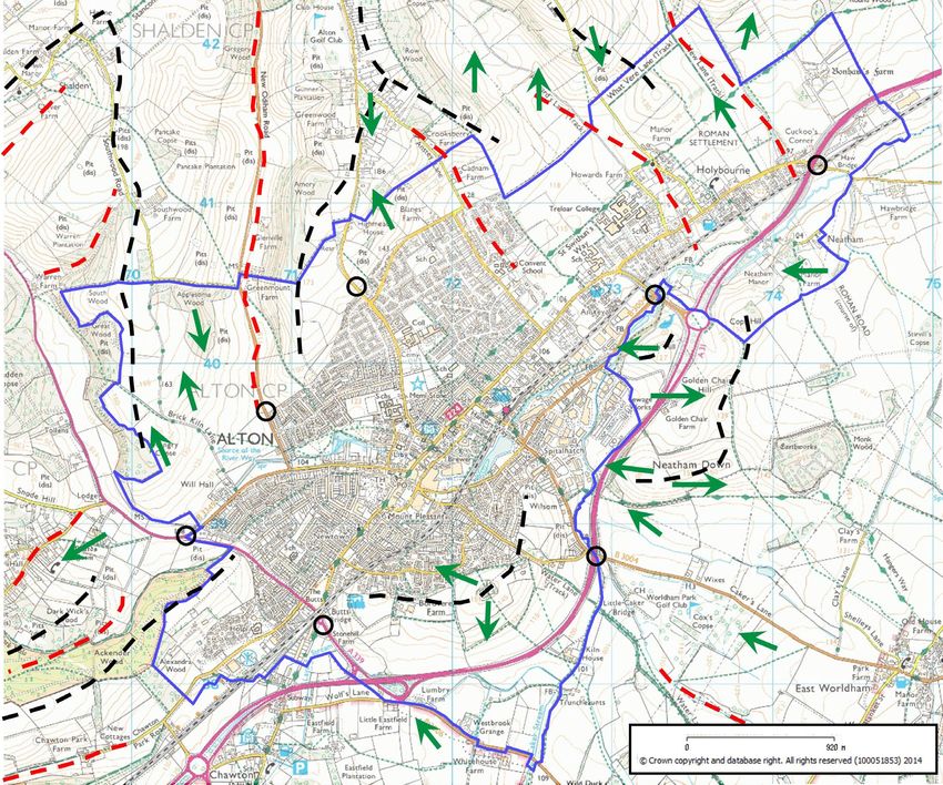
Designated Area of Alton Neighbourhood Development Plan
© Crown copyright and database right. All rights reserved (100051853) 2015
8 Alton Neighbourhood Development Plan
3. Plan development

         In line with legislative requirements, the Neighbourhood Plan was supported by the submission
         of the following documents:

         • A Basic Conditions Statement, showing how the Plan met the necessary legal
           requirements; and
         • A Consultation Statement, summarising the engagement with residents, businesses
           and stakeholders, and how their input was used. Throughout the process considerable
           emphasis was placed on reaching local people, listening to their views and testing out
           proposals with them.

         This Neighbourhood Plan has been prepared in accordance with all relevant primary and
         secondary legislation, which is principally Schedule 4B of the Town and Country Planning
         Act 1990, as amended by the Localism Act 2011, and the Neighbourhood Planning (General)
         Regulations 2012 (as later amended). This ensures that the plan policies meet the
         ‘basic conditions’.

         In accordance with the legislation, in February 2021 Alton Town Council publicised its
         intention of reviewing the Neighbourhood Plan, explaining its approach and inviting
         comments. As Covid-19 restrictions were in place, it was not possible to hold any community
         events. Details were sent to statutory consultees, and information was delivered by Royal
         Mail to every household in the Town, as well as being widely publicised on the Council’s
         website and on social media. The response was overwhelmingly supportive.

         A part of the Launch Event

Alton Neighbourhood Development Plan                                                                     9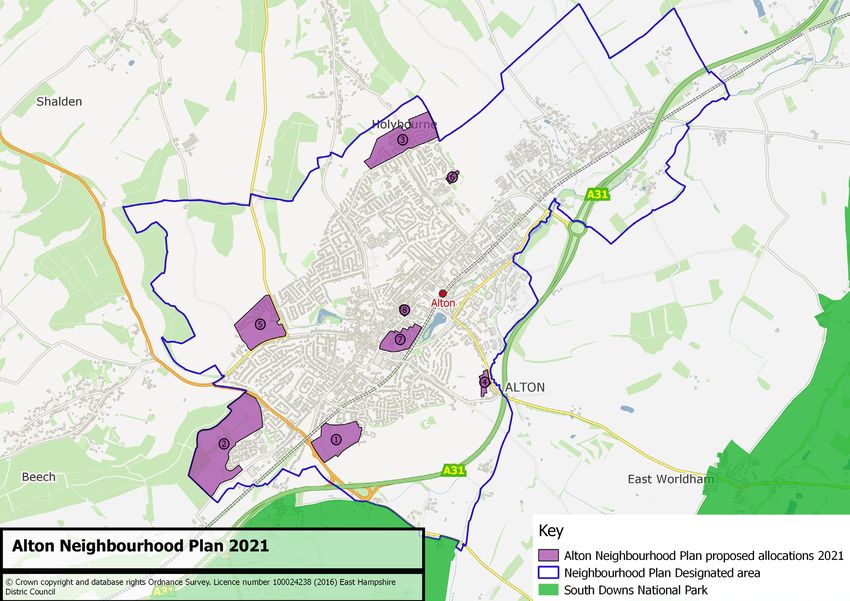
4. Overview of Alton

     Aerial view of Alton
     Alton is an historic and characterful market town in East Hampshire.

     Population: at the time of the 2011 Census it had a resident population of 17,816 within
     the Town Council boundary. Most of these live in the town, although the boundary extends
     across a ‘strategic Gap’ in the built area to include the village of Holybourne.

     Landscape: Alton is set within a distinctive chalk landscape setting, at the source of the
     River Wey. It sits relatively hidden in a hollow, which is encircled by sloping downland
     that provides a green skyline. Someone passing by on the A31 road could be forgiven for
     not realising the town lies nearby. Immediately to the south west is the northern edge of
     the South Downs National Park. Within the town are a number of cherished public open
     spaces, such as Kings Pond, Flood Meadows, Anstey Park, The Butts, the Public Gardens
     and St Lawrence Churchyard.
     Built area: although Alton has expanded in recent decades, the built-up area remains

10                                                          Alton Neighbourhood Development Plan
4. Overview of Alton
relatively contained within an area about
3 kilometres long and 2 kilometres wide.
The built environment can be described as
having four elements, namely: central older
areas; outer residential areas; industrial
areas; and Holybourne village. There are
four Conservation Areas, three in Alton
and one in Holybourne.
Transport: there is a twice-hourly direct
rail service into central London, with Alton
being at the end of the line. The town
sits just off the A31 dual carriageway –
which acts as a southern bypass – running
from Guildford to Winchester, and it is
connected to Basingstoke to the north
by the A339. There are substantial
commuting flows into, out of and through
the town. At some junctions and pinch
points, traffic congestion regularly occurs
at peak hours.
Town centre: the main focus of the town
centre is the High Street, which runs south
west to north east, with the Market Square
just off this axis in Lenten Street. It is a
commercial and social hub for the town
and its rural hinterland, and there is a
popular weekly street market. That said,
there are a number of vacant retail units.
As a retail and service centre, Alton serves
as many people from outside the town as
from within. In particular, it attracts
pupils to its secondary schools and sixth-
form college.
Alton from the air, 2007
Alton Neighbourhood Development Plan 114. Overview of Alton
Economy: the town’s mixed economy
includes two fair-sized light industrial
estates. Most businesses have been long
established in the area, although there is
evidence of a growing number of knowledge
based businesses. Brewing, which had been
a significant local industry, has declined and
the town’s remaining brewery closed during
2015. There are some tourist attractions,
including the Watercress Line steam railway,
and nearby are Jane Austen’s house at
Chawton and Gilbert White’s house at
Selborne.
A typical scene in the industrial area
Community: Alton can boast a generally high
quality of life and it is a popular, safe place to
live. As well as the schools, facilities include
various health-care facilities, a Community
Centre and a Sports Centre. There is a
strong sense of community and the people
who live here identify with Alton. It has an
active Town Council, based at the Town Hall
in the Market Square, which manages local
assets such as open spaces, sports pitches,
games pavilions and the Assembly Rooms.
There are various residents’ associations, an
Alton Society and Alton Charities Together,
amongst other groups.
The Assembly Rooms
12 Alton Neighbourhood Development Plan5. Plan scope and objectives
The Alton Neighbourhood Development Plan covers the period to 2028 and so is aligned
with the timescale of the East Hampshire: Joint Core Strategy.
The prime driver for this Plan is to manage growth positively. Taken together, developments
which are already underway and those that will result from the Joint Core Strategy allocation
represent a significant expansion of Alton. The town’s population could increase by as much
as 25% in a period of thirteen years. It is clear from the level of developer interest and
recent planning applications that this scale of growth is likely.
This raises both opportunities and challenges for sustainable growth. Alton Town Council
and its residents want to ensure that:
• Development takes place in appropriate locations;
• It happens in ways which contribute to meeting local needs; and
• Local infrastructure is able to expand at the same pace.
Growth needs to respect various constraints in the area, for example those associated with
transport networks, landscape, and flooding. It could equally boost town centre viability
and help deliver better facilities and services.
Key constraints: Main opportunities:
• Maintaining landscape setting • Providing homes to meet local needs
• Areas of significant flood risk • Boosting town centre viability
• Limitations of current road network • Improving services and facilities
• Capacity of existing sewerage system • Enhancing public open spaces
The Neighbourhood Development Plan seeks to balance these constraints and
opportunities, taking into account the preferences of local people and the practicalities of
creating a deliverable Plan.
The Alton Charter set out the scope of the Alton Neighbourhood Development Plan.
It sought objectives and policies against five themes, which are:
• Housing, including development site preferences;
• Transport and parking;
• Health, community and recreation facilities;
• Schools and education;
• Economic sustainability and viability.
Under these themes some 14 objectives were set and they are listed in the table below.
The themes and objectives draw upon the earlier work in Alton and were finalised after
assessing the evidence base, consulting widely and checking their alignment with local and
national planning policies.
Alton Neighbourhood Development Plan 135. Plan scope and objectives
Themes Neighbourhood Development Plan Related Joint Core Main NPPF or
objectives Strategy policies NPPG references
Housing 1a. To ensure that future housing development CP2, CP20, CP25, NPPF Paragraphs
(including general in and around Alton respects the character of the CP29, CP30, HE2, HE4, 127, 131, 170, 172
design issues) town and the surrounding countryside. HE5, HE6, HE7, HE8
1b. To ensure that new housing contributes to the CP10, CP11, CP13, NPPF Paragraphs
needs of the town in terms of the mix and design CP29 61, 62, 127
of dwellings.
1c. To influence the location, scale and pace of CP2, CP10, CP18, NPPF Paragraphs
housing development over the plan period CP20, CP21, CP23, 103, 108, 111 - 113, 61,
(to 2028). CP25, CP26, CP27, 65, 127, 92, 96, 98, 149,
CP28, H1 150, 157, 170 - 172,
174, 175, 180, 189, 193
1d. To ensure that, in the context of sustainability CP31, CP32 NPPF Paragraphs
requirements specified by the NPPF, the necessary 108, 109, 157
infrastructural improvements will be implemented
in a manner appropriate to the location, scale and
pace of the proposed development.
Transport 2a. To encourage and influence improvements in CP31 NPPF Paragraphs
the town’s infrastructure – particularly to manage 103, 104, 108, 109
traffic – in order to meet current needs and those
arising from development.
2b. To encourage walking and cycling. CP31, T3 NPPF Paragraphs
103 - 109
2c. To encourage the provision of public transport CP31, T2 NPPF Paragraphs
services, both within the town and beyond. 103, 108
2d. To achieve appropriate levels of parking both on CP29, CP31 NPPF Paragraph
and off street. 105
Community, health 3a. To support the development of a new/ CP8, CP16, CP17, NPPF paragraphs
and recreation refurbished Community Centre and a new Sports & HC2, HC3 92, 97
Leisure Centre in the town.
3b. To support the provision of adequate health CP8, CP16, HC3 NPPF paragraph
services for a growing population. 92
3c. To support the retention of existing public open CP17, CP18, CP28 NPPF paragraphs
spaces and the provision of new ones capable of 92, 96, 97, 99 - 101
offering sport/ recreational opportunities in line
with population growth.
Education 4a. To support the provision of sufficient nursery, CP16, CP32 NPPF paragraphs
school and college places in Alton to meet the 91, 92, 97
growing demand, in accessible locations.
Economic 5a. To protect and enhance the role of Alton town CP7, CP8, CP9 -
sustainability centre as a retail, tourism and hospitality hub which
and viability is vibrant and adaptable to future needs.
5b. To develop and enhance the business economy CP3, CP4 NPPF Paragraphs
of Alton and Holybourne, to ensure that the town is 80, 81, 85, 117 - 121,
economically sustainable. 126, 127
14 Alton Neighbourhood Development Plan6. Plan policies
This section sets out the Alton Neighbourhood Development Plan policies. Each of these is
presented within a green box and is generally preceded by an account of relevant justification
and intent. The policies necessarily focus on issues concerning land use and development.
During the course of the work to produce the Plan a number of other actions were identified
which could not be framed or were best not framed as planning policies. Some were simply
not land use or development issues. They were, nevertheless, considered important given
the views expressed by local residents and given their fit with the Plan’s objectives. These
have become action points (instead of policies) which we, Alton Town Council, have agreed to
take forward. For ease of reference they are shown under the appropriate objective within
this section of the Plan.
HOAP – Housing Action Points
TRAP – Transport Action Points
CHAP – Community & Health Action Points
EDAP – Education Action Points
ESAP – Economic Sustainability Action Points
Furthermore, this Plan does not attempt to cover every land use and development issue.
This is partly to retain focus. It is also because it does not need to address issues considered
to be dealt with sufficiently by existing (district-wide) policies in the East Hampshire Local
Plan. Those policies will still apply where this Neighbourhood Development Plan is silent.
This Plan contains no policy for designating new employment land at Alton. Key potential
sites lie just outside or astride the Alton Town Council boundary and, as such, could not be
designated by this Plan. That designation task has therefore been left to EHDC, with whom
Alton Town Council will liaise.
Alton Neighbourhood Development Plan 156. Plan policies
Summary Map of Allocated Sites also Including Overall LAA Sites within which housing is planned:
proposed Employment Sites and Existing
1. Land East of Selborne Road
Conservation Areas 2. Treloar
3. Cadnam
4. Wilsom Road
5. Will Hall Farm
6. Land adjacent to Convent
7. Molson Coors
8. Alton Magistrates Court
Sites proposed by EHDC for Employment Use:
Lynch Hill
Wilsom Road
Existing Conservation Areas:
9. Alton (Town Centre)
10. Anstey
11. The Butts
12. Holybourne
Other Areas:
13. Railway station/transport hub
South Downs National Park
16 Alton Neighbourhood Development Plan6. Plan policies - Design
DESIGN POLICIES
Policies in this section apply both to housing and other forms of development.
Objective 1a: To ensure that future housing development in and around Alton
respects the character of the town and the surrounding countryside.
DE1: Town setting and natural assets
Justification:
Alton’s setting, contained and largely hidden within a valley bowl in the North Hampshire
Downs landscape, is a defining feature which underpins its sense of place and is highly
valued. The following quotation, which is taken from the Alton Study (2013) written by
consultants for the District Council, sums it up well.
“The essence of Alton resides in the fact that the town is ‘hidden’ from the landscape
whilst being an integral part of it. Development has been constrained from breaking the
green skyline formed by the neighbouring hills, which can be seen from all parts of the
town. The undulating, yet open, nature of the land allows panoramic views which give
a sense of space, freedom and tranquillity. From most viewpoints surrounding Alton,
the town disappears within the landscape as development has not been extended to
the skyline.”
Hampshire Integrated Character Assessment - Alton Townscape Assessment (2010) describes the
historic core of the town as lying in the river Wey valley with the church and market place
standing on higher ground either side of the river source to the town’s western side. The
valley has been the defining influence on the growth of Alton. To its north is the ‘Lasham
downland mosaic’, comprising rolling chalk landforms and with long views across the Wey
valley. To its south is the ‘Worldham greensand terrace’ which is in transition to chalk hills
at this point, again with views across the River Wey. Landscape sensitivities that are noted
include the river course, areas of hanging woodlands and copses on the valley sides, and
the skyline and slopes of adjacent downland, where development and loss of tree cover
would be very visible from the valley floor. This would include designated sites within and
close to the Neighbourhood Development Plan area, such as Sites of Importance for Nature
Conservation. Such distinctive features should not be harmed.
The South Downs National Park (SDNP) was designated and became operational in April
2011. Alton sought to be included within the park boundaries, but this was not accepted
and only a very small part at the southern boundary of the town is included. However, Alton
is a gateway town and has a topography which delivers important views into and out of the
park. All efforts have been made within this Plan not to compromise this setting through
development on higher ground, including policies that allocate sites for housing.
Alton Neighbourhood Development Plan 176. Plan policies - Design
The landscape and setting is fully described in the Alton Town Design Statement, a document
which is already used by the EHDC as a material consideration in determining planning
applications. Key elements include:
• River and flood plain: the river Wey rises naturally just west of the town, then runs
through flood meadows, before passing through the town and meandering north east.
A map of high and medium risk flood zones (3 and 2 respectively) can be found on
page 10 of the Alton Study (2013);
• Vistas: the most important vistas into and out of the town were defined for the TDS and
mapped at page 5 of that document, showing their direction of view;
• Skylines: the hill-top ridges that surround much of Alton and which create the effect of it
sitting within a bowl;
• Gateways: six gateways where roads enter the town are defined and shown on
page 24 in the Alton Study (2013), to which we have added a seventh.
Map of Alton Showing Important Views into and out of Town,
Gateways, Ridge and Valley Lines from the Town Design Statement
18 Alton Neighbourhood Development Plan6. Plan policies - Design
These characteristics were considered by the formal Sustainability Assessment of
allocation sites, which was undertaken in 2014 to consider potential housing development
sites. They were also considerations within the Landscape Capacity Study (2013) for East
Hampshire District.
A further consideration is the area’s geology. If development were to extend up the hillsides
as far as the clay-with-flint capping, it could lead to surface water run off and compromise
sustainable drainage. There are several sites where development would need to pay
particular attention to drainage.
The Community Questionnaire conducted for this Neighbourhood Development Plan found
that the impact of new housing development upon the landscape and skylines was a major
concern for almost three quarters of respondents and a lesser concern for most of the
remainder. Its impact on town gateways was a major concern for over 60% of respondents
and a lesser concern for over 30%. Key issues from the Alton Town Design Statement are still
seen as highly relevant.
Intent:
This policy aligns with East Hampshire: Joint Core Strategy policy CP20 which seeks to:
protect and enhance local distinctiveness and sense of place; protect and enhance
settlements in the wider landscape, land at the urban edge and green corridors extending
into settlements; and incorporate new planting to enhance the landscape setting of
development. It also respects East Hampshire: Joint Core Strategy policy CP2, which expects
development to make the best use of previously developed land and buildings within built
up areas.
Alton Neighbourhood Development Plan 196. Plan policies - Design
DE1 Town setting and natural assets
Development proposals that impact on the discreet setting of Alton within the
surrounding landscape must demonstrate that this setting is maintained.
Development proposals that impact on key views and gateways into and out of the
town, in particular from the National Park to the south, and as shown on the plan on
page 18, must demonstrate how they have responded positively to these views and
gateways.
DE2: Building design and town character
Justification:
Alton is an attractive market town, full of character and with a long history. Residents are
proud of their town and its heritage, whilst equally recognising that the town needs to grow
to become more sustainable into the future. It is vital, therefore, that the planning system
supports development which respects and contributes to that character in terms of its
design, architecture, layout and integration with the rest of the town.
Alton has four Conservation Areas, together with many statutory Listed Buildings. There
is also a supplementary (non-statutory) Local List of buildings worthy of some protection.
This was originally prepared by the Alton Society and then recognised by EHDC before
being updated in 2014. Furthermore, a decade ago Altonians took the opportunity of
creating a general vision and plan for their town (Alton 2020), and a key output from this
was the development of a Town Design Statement (TDS) published in 2008. Both of these
documents were the product of extensive public consultation, making use of a widely
recognised Market Towns Healthcheck approach. The guidelines in the Town Design
Statement are used by EHDC as a material planning consideration.
20 Alton Neighbourhood Development Plan6. Plan policies - Design
The built environment of Alton and Holybourne is described in some detail in
Chapter 5 (Architectural Overview) of the TDS. This distinguishes key features in different
neighbourhoods, which are: the three historic areas (historic centre, New Town and
Normandy Street/Anstey Street); the three outer residential areas (western area, southern
area and northern area); the industrial areas; and Holybourne. Design considerations which
were identified as being important through the work to create the TDS include:
• Setting and landscape;
• High-quality design and respect for town character;
• The provision of amenity spaces;
• Complementary design of buildings;
• Respect for architectural surroundings e.g. scale, materials and form;
• Appropriate building heights;
• The provision of public open space.
The four Conservation Areas have their own characteristics. The Historic Centre
(designated in 1970 and extended in 1982) has a medieval street pattern, many historic
buildings, the market square, St Lawrence Church and surviving brick pavements. Anstey
(designated 1995) is a largely residential area with buildings that mostly date from the
18th or 19th centuries, the predominant building material being red brick, although many
are rendered or white washed. Street-side and large gardens are a feature. The Butts
(designated 1975) is the grassed mediaeval archery ground surrounded by mature trees
and some late Victorian housing, mostly rendered and colour-washed. Listed 18th century
buildings include a current public house (The French Horn) and a former public house (Butts
House). Holybourne village (designated 1977) contains some thirty Listed Buildings from
the 16th to 19th centuries and the partly Norman Church of the Holy Rood. Mature trees,
flint walls and high hedges along the narrow lanes are features.
Relevant comments most frequently made by those responding to the Community
Questionnaire were that new development should be of high design quality and should fit in
with its surroundings.
Alton Neighbourhood Development Plan 216. Plan policies - Design
DE2 Building design and town character
All development in Alton will be required to seek exemplary standards of design
and architecture with a high quality external appearance that respects those
characteristics of its setting.
In the context of Alton, the following should be taken into account to ensure that
development responds to the character and distinctiveness of the town.
• Development should seek to maintain and wherever possible enhance the
character of its locality, paying particular attention to appropriate appearance,
size, scale and density. Building heights should be carefully considered in
respect of their impact on the skyline of the town, landscape and streetscene;
• Where it is proposed to build to a higher density than that present in adjacent
development high-quality design must be employed to ensure that the proposal
integrates harmoniously with its surrounding environment. Any high density
residential developments must still be able to demonstrate access to adequate
levels of private amenity space;
• The appearance and materials used in development should complement,
but do not necessarily need to imitate, the best examples of building and design
in the local vicinity. Once again such design should make appropriate reference
to the scale and form of the architectural surroundings. Quality, innovative
design will be encouraged where appropriate;
• Development should seek to conserve the significance of heritage assets and
their setting.
The action point for Alton Town Council which relates to this objective is:
DEAP1: We should ensure that the Alton Town Design Statement is maintained in line with
the East Hampshire: Joint Core Strategy and with the Neighbourhood Development Plan.
22 Alton Neighbourhood Development Plan6: Plan policies - Housing
HOUSING POLICIES
Objective 1b: To ensure that new housing contributes to the needs of the town
in terms of the mix and design of dwellings.
HO1: Housing mix on development sites
Justification:
It is important that developments cater for the range of local housing needs, offering an
appropriate mix of dwelling sizes and an appropriate mix of tenures. This will help ensure
that developments promote more sustainable communities, with people from different age
groups and backgrounds.
The East Hampshire Strategic Housing Market Assessment (2013) acknowledged that the
district faces “acute pressures for affordable housing need”. The affordable housing need
across the whole district, based on net changes in household formation, was for 461
affordable dwellings per year over the next 5 years and for 256 affordable dwellings per
year over the next 17 years. According to the 2011 Census 68% of Alton households are
owner occupiers.
The district’s Homechoice list of those in housing need contained 1,985 households (April
2014). Of the 492 who expressed a need in relation to Alton, 286 (58%) were assessed as
needing a 1 bedroom dwelling, 138 (28%) as needing two bedrooms, 52 (11%) as needing
three bedrooms and 16 (3%) as needing four bedrooms. There is therefore a particular
need for smaller dwellings. This reflects the demographic profile of Alton, which consists of
30% one-person households (2011 Census).
Responses to the Community Questionnaire similarly found many with housing
affordability issues. Asked about difficulties finding suitable accommodation in Alton,
almost a fifth cited a lack of affordable housing for sale and around a fifth cited a lack of
affordable housing for rent. (These two groups may overlap.) A large majority thought it
important that new housing should help local people (including young people) to stay living
in Alton and Holybourne. The types of new housing that gain most support from residents
are starter homes, small homes and affordable homes.
Intent:
Policy HO1 therefore expects all new residential developments at Alton to include a mix of
dwellings, both in terms of size and tenure. Sustainable developments will include a good
proportion of smaller dwellings with one or two bedrooms.
The Joint Core Strategy policy expects 40% of the total number of dwellings being provided
on a site to be affordable dwellings. Affordable housing can include various tenures suited
to those whose needs are not met by the market, including social rented, affordable rented
and intermediate (or mixed tenure) housing. The affordable housing should be spread
across a new residential development, being located adjacent to market housing and not
simply clustered in distinct areas.
Alton Neighbourhood Development Plan 236. Plan policies - Housing
This policy aligns with East Hampshire: Joint Core Strategy policy CP11 which expects new
residential development to deliver a range of dwelling tenures, types and sized to meet
housing needs. It is also aligned with Joint Core Strategy policy CP13 which sets a target
for 40% of all new dwellings to be affordable housing, normally to be provided on site. The
tenure, type and size of affordable dwellings is to be negotiated with EHDC.
HO1 Housing mix on development sites
Housing development on allocated sites or other major (as defined by national
policy) housing development, must provide a range of dwelling types, tenures and
sizes to meet housing needs. On these sites, subject to being part of a wider mix,
the provision of housing that meets a range of community requirements, including
retirement, extra care housing and other housing for the elderly, those with special or
supported needs and those wishing to build their own home, will be supported.
HO2: Storage facilities for household waste
Justification:
Modern refuse and recycling practice means that households will have a number of bins and
containers which they need to store. If there is inadequate provision of storage for them,
they may be left in open view and detract from the quality of the street-level environment.
Recent experience in Alton is that adequate storage facilities have not always been
provided at developments. Guideline 5.10 of the Alton TDS also identified space for refuse
and recycling bins as important.
Waste Bin Storage at Barley Field Estate, Alton
24 Alton Neighbourhood Development Plan6. Plan policies - Housing
Intent:
Policy HO2 therefore expects all
development, whether residential or non-
residential, to provide storage facilities
for household waste and recycling bins
and containers of a size and form which
means they can be hidden from direct view
from the street. Where storage facilities
are to service communal flats, provision
should be in proportion to the number of
dwellings. Where existing properties are
being converted or subdivided, provision
should similarly be adequate for the number
of dwelling spaces being created. This policy
Waste Bin Storage at Barley Field Estate, Alton
aligns with East Hampshire: Joint Core Strategy
policy CP29, which expects development to
make provision for waste and recycling bin
storage and collection within the site.
Waste Bin Storage at Anstey Road, Alton
HO2 Storage facilities for household waste
New waste-generating residential development, including conversions or
subdivisions, will be expected to provide adequate off-street refuse storage hidden
from direct view from the street. The provision of off-street refuse storage must not
be to the detriment of the provision of an appropriate level of private amenity space
for either existing or future residents.
Alton Neighbourhood Development Plan 256. Plan policies - Housing
The action points for Alton Town Council which relate to this objective are:
HOAP1: As a statutory consultee, we should ensure that adequate emphasis is given to the
provision of affordable housing and the priority of its allocation to local residents.
HOAP2: The Alton Local List (of buildings of architectural merit but which do not warrant
national listing, as endorsed by the Town Council and District Council), should be taken into
consideration when dealing with planning applications or other issues which may impact
the integrity and merit of such buildings. This List should be maintained and updated.
HOAP3: We will prompt EHDC to ensure that the highest environmental and energy
conservation standards are met.
Objective 1c: To influence the location, scale and pace of housing development
over the plan period (to 2028).
Objective 1d: To ensure that, in the context of the sustainability requirements
specified by the NPPF, the necessary infrastructural improvements will be
implemented in a manner appropriate to the location, scale, and pace of all
proposed development.
HO3: New housing site allocations
Justification:
Based on a Strategic Housing Market Assessment and Local Housing Requirements Study
(2013), EHDC made provision in its Joint Core Strategy for 10,060 new dwellings to be built
throughout the district over the plan period from 2011 to 2028. As a market town and the
district’s largest settlement, Alton received a strategic allocation of 700 (minimum) of these
new dwellings. As noted earlier, this is in addition to 1,031 dwellings previously allocated
or with existing planning permission or expected windfall sites. Given the shortage of
currently available and deliverable brownfield sites, this required development will largely
need to take place on edge-of-town greenfield sites.
EHDC runs an annual call for available sites for such development, to which any landowner
can respond. This process, including a call in summer 2014, resulted in a database of
available sites. As part of its Strategic Housing Land Availability Assessment (SHLAA), EHDC
sifted out clearly inappropriate sites and shortlisted thirteen potential sites around Alton.
These were then subjected to a Sustainability Assessment by specialist consultants,
to review each site’s likely opportunities and constraints, taking account of a range of
environmental, social and economic factors. This was available to the Alton Neighbourhood
Plan Steering Group, as were other useful reports such as the East Hampshire Landscape
Capacity Study (2013).
26 Alton Neighbourhood Development Plan6. Plan policies - Housing
The Community Questionnaire provided an
initial set of views from residents.
It found that the main concerns with
regard to new housing development were:
adequate infrastructure (a major concern
for 91%); environmental impact (87%);
traffic generation (80%); and impact on the
landscape and skylines (74%). Residents felt
strongly that infrastructure (roads, schools,
etc) must keep pace with and be in place for
housing growth. Residents also commented
frequently on the potential for water
run-off from slopes around the town to
impact development sites.
Evidence of rain water run-off leading to flooding
from high ground in North Alton across
Gilbert White Way
Evidence of rain water run-off leading to flooding from high ground in North Alton
Residents were asked about specific larger SHLAA sites. There was (net) support for
development at only one (Lord Mayor Treloar), although opposition to another was
relatively modest (Borovere). The scale of the allocation to Alton means, of course, that
other significant sites must be identified for development. Selecting them, however,
took particular account of residents’ views about infrastructure, environment, traffic and
landscape, including where impacts could be minimised or mitigated. It also took account
of views expressed at a further community engagement exercise in November 2014, when
more useful information about preferences was generated in response to a presentation on
emerging site allocations. The Modified Plan community engagement exercise in February
and March 2021 echoed this position.
Alton Neighbourhood Development Plan 276. Plan policies - Housing
Comments provided to date by statutory bodies have been taken carefully into account.
Perhaps the most important are comments from Thames Water about public sewerage and
waste water infrastructure. Most development sites at Alton will require works to upgrade
and increase capacity in the current infrastructure.
Weighing up the preferences, evidence and constraints, sites have been selected which
meet the necessary criteria by being available for development, deliverable (built) within
the plan period and capable of development in a sustainable way.
Intent:
Policy HO3 allocates six sites at Alton with a total capacity for 877 new dwellings over the
plan period to 2028. Those sites are listed in the policy below.
The total allocation below takes account of three factors. First, the need to provide a
buffer (over and above the minimum 700), in line with good planning practice and in
case some sites do not come forward as expected. Second, a requirement placed on this
Neighbourhood Development Plan to compensate for a reduction by 60 in the number of
dwellings expected to be built on part of Lord Mayor Treloar which was allocated some
years ago. Third, the need to reflect outline planning permissions now granted for an
additional 156 dwellings at Land East of Selborne Road and Lord Mayor Treloar.
Additionally, the modification process reviewed and updated the allocation policies as
indicated in the table below.
The allocation made in this Neighbourhood Development Plan relates to the requirement
for the entire Neighbourhood Plan area, including Alton town and Holybourne village. This
makes use of the flexibility afforded to Neighbourhood Development Plans and the paucity
of suitable development sites in Holybourne.
HO3 New Housing Site Allocations
Permission will be given for new housing as set out in the table immediately below
and as shown on site allocation plans.
Site name Policy Dwelling 2021 Modification
number allocation
Land East of Selborne Road HO3(a) 242 Allocation to be modified in terms of
development capacity (reduced) due to now
having further detailed information regarding
site constraints as evidenced in planning
application number 30021/065.
Land at Lord Mayor Treloar HO3(a) 280 Existing allocation retained as result of
NB. For the avoidance of confusion, this amounts to either being at early stages of being built out
the total allocation at Lord Mayor Treloar and reflects or have not yet commenced.
the outline planning permission granted in July 2015.
Land off Wilsom Road HO3(c) 11 Allocation to be modified in terms of
development capacity (reduced) due to now
(between numbers 60 and 86) having further detailed information regarding
site constraints as evidenced in planning
application numbers 55638/001 and
33920/008.
Land adjacent to Alton Convent HO3(e) 18 Existing allocation retained as result of either
being at early stages of being built out or have
School, Anstey Lane not yet commenced.
Molson Coors HO3(f) 283 New housing sites within existing Settlement
Policy Boundary both coming forward through
Alton Magistrates Court 43 the planning application process now.
Total allocation 877
28 Alton Neighbourhood Development Plan6. Plan policies - Housing
The Neighbourhood Development Plan is not in a position to specify the exact phasing of
development on these sites. The speed at which new housing can be built will be largely
dictated by infrastructure constraints, which will in practice spread delivery over much of
the Plan period.
The location of the six allocated sites is shown on the following proposals map of Alton.
Summary Map of Allocated Sites Overall LAA Sites within which housing is planned:
1. Land East of Selborne Road
2. Treloar
3. Cadnam
4. Wilsom Road
5. Will Hall Farm
6. Land adjacent to Convent
7. Molson Coors
8. Alton Magistrates Court
Alton Neighbourhood Development Plan 296. Plan policies - Housing
The aim is to ensure sustainable development at each of these sites. The following
therefore provides, where appropriate, a description of the development that would be
permitted, information on constraints that must be addressed and information about public
benefits which they will be expected to deliver. It notes certain infrastructure requirements
that will have to be addressed before dwellings can be built or occupied. These will need
to be fully addressed within the documentation for site planning applications and after
having been properly considered to the satisfaction of the relevant statutory bodies. In
particular, developers should demonstrate there is adequate waste water/sewerage
capacity and surface water drainage, both onto and off the site, to serve their specific
development proposal and that it would not lead to problems for existing or new users. In
some circumstances this may make it necessary for developers to carry out appropriate
site specific drainage studies to ascertain whether the proposed development will overload
existing infrastructure. Where there is a capacity problem and no improvements are
programmed by the water company, the developer needs to agree required improvements
with the water company and their funding, prior to any occupation of the development.
Specific Housing Sites
The following provides policy information for each allocation site and a map showing site
boundaries, indicating any specific areas of land that are expected to be left as open green space.
30 Alton Neighbourhood Development Plan6. Plan policies - Housing
HO3(a) Land east of Selborne Road site
Land is allocated East of Selborne Road (242 dwellings) and at Lord Mayor Treloar
(280 dwellings) for a total of 522 dwellings. This reflects planning permission
granted in July 2015. The developable boundaries of these sites are shown on the
following two plans.
Borovere Farm Site. © Crown copyright and database right.
All rights reserved (100051853) 2015
Alton Neighbourhood Development Plan 316. Plan policies - Housing
0 380 m
Treloar Site, showing in green the areas © Crown copyright and database right.
not to be developed. All rights reserved (100051853) 2015
32 Alton Neighbourhood Development Plan6. Plan policies - Housing
Policy HO3(b) (Land at Cadnam, Upper Anstey Lane) DELETED
Alton Neighbourhood Development Plan 336. Plan policies - Housing
HO3(c) Land off Wilsom Road (between numbers 60 and 86)
Land is allocated off Wilsom Road for a total of 11 dwellings. This reflects planning
permissions granted in October 2018 and March 2020. The developable boundary
of this site is shown on the following plan.
34 Alton Neighbourhood Development Plan6. Plan policies - Housing
Wilsom Road Site. © Crown copyright and database right.
All rights reserved (100051853) 2015
Alton Neighbourhood Development Plan 356. Plan policies - Housing
Policy HO3(d) (Land at Will Hall Farm) DELETED
36 Alton Neighbourhood Development Plan6. Plan policies - Housing
Policy HO3(d) (Land at Will Hall Farm) DELETED
Alton Neighbourhood Development Plan 376. Plan policies - Housing
HO3(e) Land adjacent to Alton Convent School, Anstey Lane
This 0.5 hectare site, comprising surplus and overgrown land to the rear of Alton
Convent School, is allocated for residential use.
The site will deliver a high quality development that will:
• Make provision for approximately 18 dwellings with an indicative net density
of 36 dwellings per hectare;
• Seek to retain or replace mature trees on site.
38 Alton Neighbourhood Development Plan6. Plan policies - Housing
Convent Site. © Crown copyright and database right.
All rights reserved (100051853) 2015
Alton Neighbourhood Development Plan 396. Plan policies - Housing
HO3 (f) Molson Coors and Alton Magistrates Court:
Land is allocated at Molson Coors (283 dwellings) and at Alton Magistrates Court
(43 dwellings) for a total of 326 dwellings. This reflects the resolution to grant in
respect of Molson Coors 250050/059 and the grant of planning permission at Alton
Magistrates Court 56420/001. The developable boundaries of these sites are shown
on the following two plans.
40 Alton Neighbourhood Development Plan6. Plan policies - Housing
Molson Coors site
Alton Magistrates Court site
Alton Neighbourhood Development Plan 416. Plan policies - Transport
TRANSPORT POLICIES
The policies in this section seek to ensure that Alton’s future transport needs are properly
met, making allowance for the town’s planned growth. The road network will require
adaptation and improvement, and new housing developments will realistically need to
provide sufficient parking space. Policies will also make it easier for people to walk, cycle or
take public transport, thus reducing the demand for motorised transport.
Objective 2a: To encourage and influence improvements in the town’s
infrastructure – particularly to manage traffic – in order to meet current needs
and those arising from development.
42 Alton Neighbourhood Development Plan6. Plan policies - Transport
Alton’s Road Network © Crown copyright and database right.
All rights reserved (100051853) 2015.
Map copied from EHDC Alton Study Issue 5
dated 03 Jun 13 prepared for EHDC
by Urban Initiatives Studio Ltd.
Alton Neighbourhood Development Plan 436. Plan policies - Transport
Junctions known to be overloaded © Crown copyright and database right. All rights reserved
at present during peak periods. (100051853) 2015. Map copied from EHDC Alton Study Issue 5
dated 03 Jun 13 prepared for EHDC by Urban Initiatives Studio Ltd.
1. Butts Road – Whitedown Lane;
2. Whitedown Lane – Chawton Park Road;
3. Basingstoke Road – Whitedown Lane;
4. Wilsom Road – Ashdell Road – Paper Mill Lane – Mill Lane;
5. Mill Lane – Montecchio Way;
6. Anstey Road – Anstey Lane; and
7. London Road – Montecchio Way.
44 Alton Neighbourhood Development Plan6. Plan policies - Transport
Butts Bridge – a brick arch structure.
Alton Neighbourhood Development Plan 456. Plan policies - Transport
Roads in developments should be capable of adoption as public highway
The action points for Alton Town Council which relate to this objective are:
TRAP1: We will press the Local Highway
Authority to reduce the impact of traffic
flows on A339 Whitedown Lane. A
reduction in heavy traffic is most likely to be
achieved through the provision of a Western
Bypass.
TRAP2: We will prompt the Local Highway
Authority to prepare a timetable for works
to improve operation and reduce delays at
key junctions within the town, particularly:
• Anstey Road / Anstey Lane;
“Severance” - heavy traffic on Whitedown
• Mill Lane / Paper Mill Lane / Ashdell Road / Lane cuts off the Leisure and Health
Wilsom Road (at Spitalhatch); facilities from the rest of the town.
• Butts Road / Winchester Road;
• Whitedown Lane / Chawton Park Road;
• Whitedown Lane / Basingstoke Road;
• Basingstoke Road / New Odiham Road;
• Mill Lane / Montecchio Way.
46 Alton Neighbourhood Development PlanYou can also read