PORTLAOISE DRAFT LOCAL AREA PLAN - Laois County Council Comhairle Chontae Laoise 2018 2024
←
→
Page content transcription
If your browser does not render page correctly, please read the page content below
Laois County Council
     Comhairle Chontae Laoise

PORTLAOISE DRAFT LOCAL AREA PLAN

           2018 – 2024
Portlaoise Local Area Plan 2018 - 2024

                                                                                                                                           CONTENTS

1     Introduction .......................................................................................................................................... 6
2     Legislative Requirements ...................................................................................................................... 7
    2.1      Strategic Environmental Assessment............................................................................................ 8
    2.2      Appropriate Assessment ............................................................................................................... 8
    2.3      Strategic Flood Risk Assessment ................................................................................................... 8
3     Other Plans & Guidelines ...................................................................................................................... 9
4     Portlaoise in Context ........................................................................................................................... 10
5     History of Portlaoise............................................................................................................................ 11
6     Urban Form ......................................................................................................................................... 12
7     Spatial Planning Policy ........................................................................................................................ 13
    7.1      Project Ireland 2040 National Planning Framework ................................................................... 13
    7.2      Project Ireland 2040 National Development Plan 2018—2027 .................................................. 14
      7.2.1          Regeneration Demonstration Project - Portlaoise.................................................................15
      7.2.2          Other Strategic Infrastructure/Investment identified for Portlaoise ....................................15
    7.3      Regional Planning Guidelines FOR Midland Region 2010 – 2022 ............................................... 15
    7.4      Regional Spatial and Economic Strategy ..................................................................................... 17
8     Development Vision & Strategy .......................................................................................................... 19
    8.1      Key Plan Objectives ..................................................................................................................... 20
    8.2      Town Centre – Key Objectives .................................................................................................... 21
    8.3      Core Strategy............................................................................................................................... 22
    8.4      Function, Population and Scale of Portlaoise ............................................................................. 22
    8.5      Future Development Priorities ................................................................................................... 24
      8.5.1          Housing / Residential Land Availability ..................................................................................24
      8.5.2          Town Centre Consolidation....................................................................................................24
      8.5.3          Portlaoise Public Realm Strategy “2040 And Beyond: A Vision For Portlaoise” ....................24
      8.5.4          Economic Development .........................................................................................................25
      8.5.5          Key Infrastructure ..................................................................................................................25
      8.5.6          Environment and Heritage Protection ...................................................................................25
9     Economic Development ...................................................................................................................... 26

                                                                                2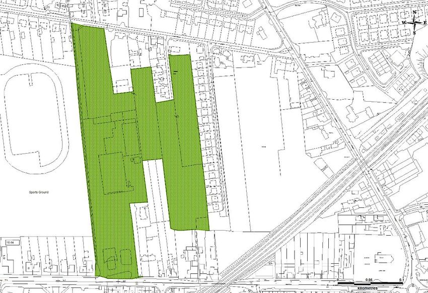
Portlaoise Local Area Plan 2018 - 2024

10      Town Centre Revitalisation ............................................................................................................. 31
 10.1          2040 And Beyond: A Vision for Portlaoise: ............................................................................. 34
 10.2      Opportunity Sites ........................................................................................................................ 36
     10.2.1         Opportunity Site 1: Lyster Square .........................................................................................37
     10.2.2         Opportunity Site 2: Fitzmaurice Place including the school sites ........................................38
     10.2.3         Opportunity Site 3: Centre point, Mountrath Road ..............................................................39
     10.2.4         Opportunity Site 4: The Maltings Site, Mountmellick Road.................................................40
     10.2.5         Opportunity Site 5: Former Bank of Ireland Branch Office/Prison Officers’ Club.................41
11      Key Infrastructure ........................................................................................................................... 42
12      Transport and Movement ............................................................................................................... 45
13      Housing ........................................................................................................................................... 51
14      Community Services & Culture ....................................................................................................... 57
15      Built Heritage .................................................................................................................................. 60
16      Natural Heritage.............................................................................................................................. 65
17      Flood Management ......................................................................................................................... 69
18      Implementation .............................................................................................................................. 72
 18.1      Land Use Zoning .......................................................................................................................... 72
 18.2      Land Use Zoning Matrix .............................................................................................................. 77

                                                                              3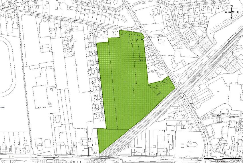
Portlaoise Local Area Plan 2018 - 2024

                                                                                                                            LIST OF FIGURES
Figure 1: LAP Process ......................................................................................................................................... 7
Figure 2: Portlaoise, Co. Laois ..........................................................................................................................10
Figure 3: Undated Map of Maryborough ........................................................................................................11
Figure 4: Ordnance Survey First Edition, 1839 ................................................................................................11
Figure 5: Google Earth Image 29/9/15 ............................................................................................................12
Figure 6: Planning Hierarchy ............................................................................................................................13
Figure 7: National Strategic Outcomes ............................................................................................................14
Figure 8: Portlaoise in the context of the Midlands Region ............................................................................16
Figure 9: Strategic Aims ...................................................................................................................................19
Figure 10: JFL Public Realm Improvements                                     Figure 11: River Triogue Blueway ................................21
Figure 12: Redevelopment of Opportunity Sites                                Figure 13: Redevelopment of The Laneways ...............22
Figure 14: Labour Force by Principle Economic Status ....................................................................................27
Figure 15: Views from the 3D model, existing and proposed .........................................................................35
Figure 16: Lyster Square ..................................................................................................................................37
Figure 17: Fitzmaurice Place including Schools ...............................................................................................38
Figure 18: Centre Point ....................................................................................................................................39
Figure 19: The Maltings Site ............................................................................................................................40
Figure 20: Bank Place .......................................................................................................................................41
Figure 21: Commuting by means of travel to work, school or college ............................................................46
Figure 22: The proposed traffic cells of the Portlaoise Public Realm Strategy................................................47
Figure 23: Protected Structures and Architectural Conservation Area Portlaoise ..........................................61
Figure 24: Overlay of Fort remains on contemporary map .............................................................................62
Figure 25: Portlaoise Leisure Centre and Playground .....................................................................................66
Figure 26: Portlaoise Habitat Map (Biodiversity Plan).....................................................................................66

                                                                               4
Portlaoise Local Area Plan 2018 - 2024

                                                                                                                   LIST OF TABLES

Table 1: Population statistics for County Laois and Portlaoise between 2002 and 2016 ...............................22
Table 2: Population by age cohort                    Table 3: Population by Nationality ...................................................23
Table 4: Core Strategy Table of Laois County Development Plan 2017-2023 .................................................23
Table 5: Households by accommodation type ................................................................................................51
Table 6: Households by composition...............................................................................................................52

                                                                                                                       LIST OF MAPS

Map 1: Togher Master Plan Area
Map 2: The Integrated Strategy of 2040 and Beyond: A Vision for Portlaoise
Map 3: Housing Protection Areas
Map 4: Archaeological Significance Zone
Map 5: Architectural Conservation Area
Map 6: Protected Structures
Map 7: Land Use Zoning Map
Map 7a: Land Use Zoning & Flooding
Map 8: Objectives

                                                                        5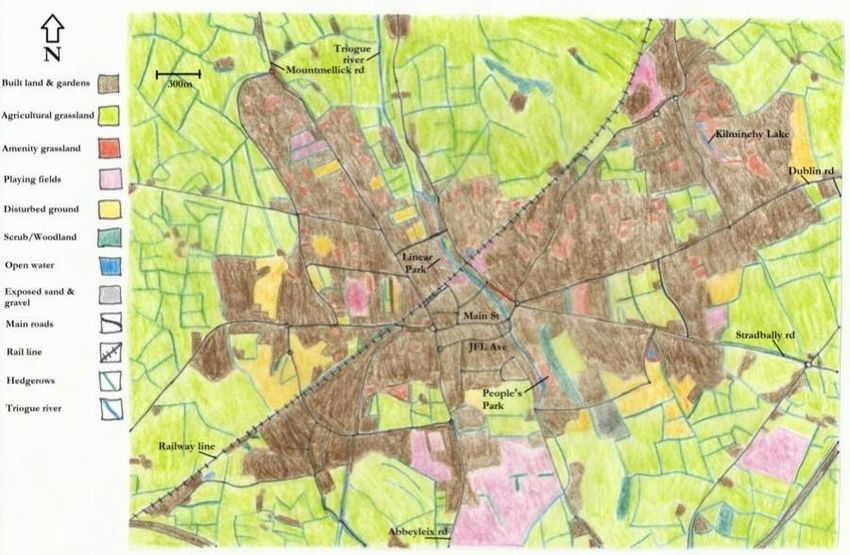
Portlaoise Local Area Plan 2018 - 2024

                                                                     1       INTRODUCTION

This Portlaoise Draft Local Area Plan 2018 – 2024 (LAP) has been prepared in accordance with the
requirements and provisions of the Planning and Development Act 2000, as amended (hereafter
referred to as ‘the Act’). The Draft LAP sets out an overall strategy for the proper planning and
sustainable development of Portlaoise, in the context of the Laois County Development Plan 2017
– 2023 and the Midland Regional Planning Guidelines 2010 – 2022. The Draft LAP has also been
informed by Ministerial Guidelines issued pursuant to Section 28 of the Act, together with EU
requirements regarding Strategic Environmental Assessment (SEA) and Appropriate Assessment
(AA).

The Draft Local Area Plan comprises a written statement and accompanying maps. The written
statement shall take precedence over the map should any discrepancy arise. In the full
interpretation of all objectives for Portlaoise, it is essential that both the County Development
Plan (CDP) and the Draft LAP are read together. Where conflicting objectives arise between the
CDP and the Draft LAP, the objectives of the CDP shall take precedence. It should be noted that
the general development management standards applicable to the plan area are included in the
CDP, while policies and objectives that are specific to Portlaoise are included in the Draft LAP.

                                               6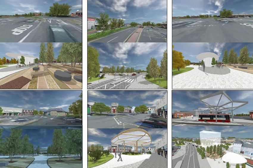
Portlaoise Local Area Plan 2018 - 2024

                                                     2          LEGISLATIVE REQUIREMENTS

Sections 19 of the Planning and Development Act 2000 (as amended) requires that an LAP be
prepared in respect of an area which –

(i)   Is designated as a town in the most recent census of population, other than a town
      designated as a suburb or environs in that census,
(ii) Has a population in excess of 5,000, and
(iii) Is situated within the functional area of a Planning Authority which is a County Council.

The CSO Census 2016 confirmed that Portlaoise has a total population of 22,050 persons. An LAP
is therefore statutorily required for Portlaoise.

Section 20 of the Act sets out the process for the making of a Local Area Plan as illustrated in the
follow diagram:

                                        Figure 1: LAP Process

                                                 7
Portlaoise Local Area Plan 2018 - 2024

In accordance with Section 19 and 28 of the Act the Draft LAP is subject to the following
environmental considerations:

2.1    STRATEGIC ENVIRONMENTAL ASSESSMENT

Strategic Environmental Assessment (SEA) is required in accordance with the SEA Directive (DIR
2001/42/EC). SEA is a formal, systematic evaluation of the likely significant environmental effects
of implementing a plan, policy or programme. SEA is mandatory for plans for areas with a
population of 5,000 or more and is therefore required for the Portlaoise Draft LAP.

Minogue and Associates, Environmental Consultants have been appointed by Laois County Council
to undertake the SEA as part of the preparation of the Draft LAP. In this regard, an SEA
Environmental Report has been prepared informing the likely environmental impacts of
implementing the policies and objectives of the plan and integrating relevant environmental
considerations into the plan. The SEA Environmental Report (SEA ER) accompanies this Draft LAP.
Mitigation measures recommended in the SEA ER have been incorporated into this Draft LAP. This
report sets out the likely environmental consequences of decisions regarding the location and
type of developments within the plan area, mitigation measures to offset potential adverse effects
of the plan and monitoring proposals.

2.2    APPROPRIATE ASSESSMENT

Appropriate Assessment (AA) is required in accordance with Article 6(3) and 6(4) of the EU
Habitats Directive (DIR 92/43/EEC). AA is a focused and detailed impact assessment of the
implications of the plan or project, alone and in combination with other plans and projects, on the
integrity of a Natura 2000 site in view of its conservation objectives.

Minogue and Associates, Environmental Consultants have been appointed by Laois County Council
to undertake Appropriate Assessment as part of the preparation of the Draft LAP.

Following screening for AA, it was determined that the Portlaoise Draft LAP is likely to have a
significant impact on areas designated as a Natura 2000 site, therefore a Natura Impact Report
must be prepared. The mitigation measures identified in the Stage 2 Appropriate Assessment
(Natura Impact Report) have been incorporated into the Plan.

2.3    STRATEGIC FLOOD RISK ASSESSMENT

A Strategic Flood Risk Assessment (SFRA) is required in accordance with “The Planning System and
Flood Risk Management – Guidelines for Planning Authorities” as amended by Circular PL2/2014.
The primary purpose of the SFRA is to determine flood risk within a particular geographical area
and to support planning decisions in relation to developing the plan.

                                                8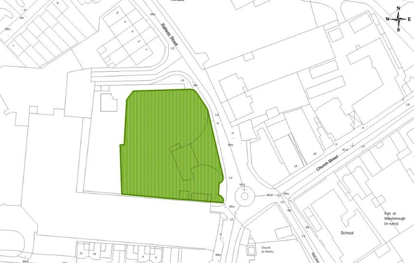
Portlaoise Local Area Plan 2018 - 2024
3 OTHER PLANS & GUIDELINES
The Draft LAP has been prepared having regard to national, regional and local policy documents,
in addition to Guidelines issued under Section 28 of the Planning and Development Acts 2000 (as
amended), including the following:
Project Ireland 2040 National Planning Framework (2018)
National Spatial Strategy 2002-2020 (NSS)
Midland Regional Planning Guidelines 2010 - 2022 (2010)
Laois County Development Plan 2017 - 2023
Laois Local Economic and Community Plan 2016 – 2021
Local Area Plan Guidelines for Planning Authorities (2013)
Manual for Local Area Plans (2013)
Planning System and Flood Risk Management Guidelines for Planning Authorities (2009)
Our Sustainable Future, A Framework for Sustainable Development for Ireland (2012)
Smarter Travel, A Sustainable Transport Future 2009 - 2020 (2009)
Building on Recovery; Infrastructure and Capital Investment 2016 - 2021 (2014)
Rebuilding Ireland – Action Plan for Housing the Homelessness (2016)
National Climate Change Adaptation Framework; Building Resilience to Climate Change
(2012)
National Energy Efficiency Action Plan 2009 - 2020 (2009)
National Renewable Energy Action Plan (2010)
Government Policy Statement on the Strategic Importance of Transmission and Other
Energy Infrastructure (2012)
Spatial Planning and National Roads Guidelines for Planning Authorities (2012)
National Cycle Policy Framework
Water Services Strategic Plan, A Plan for the Future of Water Services
Water Supply Project Eastern & Midlands Region
Eastern and South Eastern River Basin Management Plan (2009 - 2015)
National Broadband Plan 2012
Laois Heritage Plan 2014 - 2019
Framework and Principles for the Protection of the Archaeological Heritage (1999)
Architectural Heritage Protection – Guidelines for Planning Authorities (2011)
Actions for Biodiversity – Ireland’s National Biodiversity Plan 2011-2016 (2011)
9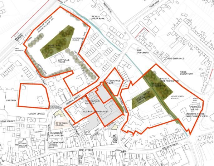
Portlaoise Local Area Plan 2018 - 2024

                                                              4         PORTLAOISE IN CONTEXT

Portlaoise is the principal town and administrative centre for the County of Laois. Portlaoise is
strategically located at a national, regional and local level. The town is located on the M7/M8
National Motorway Network which enables easy access to Cork, Limerick and Dublin including
Dublin Airport and Port. The N80, National Secondary route extends through Portlaoise and
provides access to Carlow, Waterford and Rosslare to the south and Tullamore, Mullingar and
Athlone to the north. Portlaoise is also located on the Dublin to Cork railway line, which provides a
high degree of rail connectivity nationally.

                                     Figure 2: Portlaoise, Co. Laois

Portlaoise is the largest source of non-agricultural employment within the county and is
dominated by the services sector with employment in Central (Department of Justice, Equality and
Law Reform) and Local Government, the E.S.B., Eir, An Post, Education and the Health Service
Executive. The Togher National Enterprise Park consists of a 121 ha. land bank on the southern
outskirts of the town.

Portlaoise has experienced considerable urbanisation and expansion in recent years. Due to its
proximity to Dublin, Portlaoise has experienced significant population growth, which has in turn
placed an even greater demand on the town’s infrastructure, in particular education, housing,
recreational amenities and services.

                                                   10
Portlaoise Local Area Plan 2018 - 2024
5 HISTORY OF PORTLAOISE
The present town grew around the old fort, the construction of which commenced in 1548 under
the supervision of Lord Deputy Sir Edward Bellingham, who was anxious to fortify Leix following
his repression of the natives and the exiling of their Chieftains earlier in the year. The fort was
built primarily for military and political purposes. The fort is situated on rising ground southeast of
the river Triogue and with the Esker ridge forming a natural defensive barricade to the east, made
it of strategic military importance. In 1570 a charter of Queen Elizabeth I raised the town of
Maryborough to the rank of Borough. In 1922 the town was renamed Portlaoise.
Figure 3: Undated Map of Maryborough
Figure 4: Ordnance Survey First Edition, 1839
11Portlaoise Local Area Plan 2018 - 2024
6 URBAN FORM
The urban form of the town is dominated by a linear Main Street, terminated on each end by a
Square, Market Square to the west and Lower Square to the east. The construction of the inner
relief road James Fintan Lalor Avenue, facilitated the southern expansion and development of the
town. The opening of Portlaoise By-Pass in 1997 had a significant effect on the physical
environment and future development of the town with 65% of through traffic removed. In
addition, travel time to Dublin was reduced to less than an hour with the opening of the Heath-
Mayfield section of motorway in 2004. The historical core of the town is focused on a zone of
archaeological interest around Church Street/Church Avenue wherein lies the Courthouse and the
remaining portions of the Fort Protector.
Figure 5: Google Earth Image 29/9/15
The town centre area contains a large number of Protected Structures and is designated as an
Architectural Conservation Area, reflecting its special architectural interest. The Built Heritage of
the town is discussed in further detail in the Built and Natural Heritage chapter of this Draft LAP.
Portlaoise is constrained to the east and northeast by the Portlaoise Aquifer Protection Zone,
which provides the public water supply for the greater Portlaoise and Mountmellick area. The
motorway provides a physical boundary to the south east and south. The Dublin/Cork Railway line
intersects the town in a North/East-South/West direction.
12Portlaoise Local Area Plan 2018 - 2024
7 SPATIAL PLANNING POLICY
The Irish spatial planning hierarchy is set out in the following diagram:
Figure 6: Planning Hierarchy
7.1 PROJECT IRELAND 2040 NATIONAL PLANNING FRAMEWORK
“Project Ireland 2040” is the Government’s overarching policy initiative to make Ireland a better
country for all of us, a country that reflects the best of who we are and what we aspire to be.
Project Ireland 2040 is informed by the Programme for a Partnership Government 2016, which
recognizes that economic and social progress go hand in hand, and is made up of the “Project
Ireland 2040 National Planning Framework” (NPF) and the “National Development Plan 2018-
2027” (NPD).
The NPF replaces the National Spatial Strategy (NSS) 2002-2020. The NPF in conjunction with
the NDP is the Government’s plan to cater for the extra one million people that will be living in
Ireland, the additional two thirds of a million people working in Ireland and the half a million
extra homes needed in Ireland by 2040.
13Portlaoise Local Area Plan 2018 - 2024
Project Ireland 2040 seeks to achieve ten strategic outcomes, building around the overarching
themes of wellbeing, equality and opportunity. The ten shared National Strategic Outcomes
and Priorities of the National Development Plan will ensure a consistent approach between
planning objectives under the NPF and investment commitments under the NDP. The Ten
Strategic Outcomes and Priorities are outlined in the following diagram:
Figure 7: National Strategic Outcomes
As a strategic development framework “Project Ireland 2040” sets the long-term context for
our country’s physical development and associated progress in economic, social and
environmental terms and in an island, European and Global context. “Project Ireland 2040” will
be followed and underpinned by supporting policies and actions at sectoral, regional and local
levels.
7.2 PROJECT IRELAND 2040 NATIONAL DEVELOPMENT PLAN 2018—2027
Under the Urban Regeneration and Development Fund Portlaoise has been identified as a
location with potential to receive funding for an urban design and renewal initiative. The Urban
Regeneration and Development Fund comprises a purse of €2 billion with the aim of achieving
sustainable growth in Ireland’s five cities and other large urban centres. This will be achieved by
putting in place a centrally managed mechanism to drive collaborative, co-ordinated and
complementary packages of investment between Departments, agencies, Local Authorities and
14Portlaoise Local Area Plan 2018 - 2024
other public bodies in pooling their assets and working with local communities and the private
sector to transform our cities and towns.
7.2.1 REGENERATION DEMONSTRATION PROJECT - PORTLAOISE
The aim of this project is to focus on regenerating the original town centre and main street
areas and how they relate to the expanded town, with a view to creating more attractive,
desirable places that people want to live and spend time in. The Demonstration Project will be
initiated on a community and locally led urban design and renewal initiative. The national
Regeneration and Development Agency, with investment from the Urban Regeneration and
Development Fund and wider community and local businesses, will create and deliver a new
vision for the centre of Portlaoise, to show how the best quality planning, urban design and
implementation can create a rejuvenated town. There will be a particular focus on self-
sustaining and community-driver renewal.
7.2.2 OTHER STRATEGIC INFRASTRUCTURE/INVESTMENT IDENTIFIED FOR
PORTLAOISE
Transport Regional and Local Roads:
Portlaoise Southern Distributor Road will be progressed over the course of the National
Development Plan.
Health:
Mental Health project in Portlaoise for a 40 bed Residential Unit.
Courts Service:
Provision of a new or refurbished Courthouse for Portlaoise.
Prison Service:
Modernisation or replacement of the historic E Block in Portlaoise Prison.
7.3 REGIONAL PLANNING GUIDELINES FOR MIDLAND REGION 2010 – 2022
The Midland Regional Planning Guidelines 2010 - 2022 (MRPGs) identifies Portlaoise as a
‘Principal Town’ within the Southern Development Area (SDA). The SDA borders the South East
Region and the Mid West Region and encompasses County Laois, excluding Portarlington.
Portlaoise is the largest urban centre and economic driver in the south Midlands. Portlaoise’s
primacy within the context of County Laois has been emphasised within the Laois County
Development Plan 2017-2023.
The Core Strategy in accordance with the provisions of the Act requires the correlation of the
population targets of the MRPGs with housing land requirements of the settlement hierarchy.
The Core Strategy is set out under the Laois County Development Plan 2017-2023.
15Portlaoise Local Area Plan 2018 - 2024
The MRPGs envisages Portlaoise as having strong national development potential, as a major
transport hub and distribution centre. Major road and rail infrastructure investment has taken
place maximising the accessibility of the town. Future development of the SDA will require the
strengthening and consolidation of the existing infrastructure that forms an important element
in the prosperity of the region. Existing strengths should be built upon, including opportunities
in transport based industries such as freight and logistics.
Figure 8: Portlaoise in the context of the Midlands Region
The allocation of serviced land at Togher Inland Port as a National Enterprise Park for
enterprise, employment and industrial uses in the immediate vicinity of national strategic
transport infrastructure represents a unique opportunity to develop a cluster of
complementary enterprises and a diverse economic base for the county and the region. This
fulfils objectives set out within the MRPGs, in particular the following:
16Portlaoise Local Area Plan 2018 - 2024
EDP6: Priority should be given to targeting the development and support the
progression of the logistics and distribution sector, in particular the development
of the ‘Togher Inland Port’ in Portlaoise.
EDO4: Facilitate the development of the ‘Togher Inland Port’ at Portlaoise through the
delivery of the provisions of the Togher Masterplan ensuring that employment
and enterprise opportunities are fully maximised through promotion and relevant
interagency collaboration.
SDA P6: Fulfill the potential of Portlaoise and Togher Inland Port to become a major
transport hub and distribution centre, by building on its strategic location at the
intersection of key national road and rail routes.
The ability of the lands at Togher to service the needs of large Foreign Direct Investment (FDI)
should be maximized and will be developed during this plan period.
7.4 REGIONAL SPATIAL AND ECONOMIC STRATEGY
Since the Midland Regional Planning Guidelines (RPGs) were published in 2010, a new
administrative structure at regional level has been developed as directed by the Local
Government Reform Act 2014. The Local Government Reform Act included the abolition of
eight Regional Authorities and the creation of three Regional Assemblies. County Laois now
forms part of the Eastern and Midland Regional Assembly (EMRA) along with eleven other
counties. This area further comprises three Strategic Planning Areas with Offaly, Laois,
Westmeath and Longford forming part of the Midland Strategic Planning Area. The EMRA are
responsible for the preparation of a new Regional Spatial and Economic Strategy (RSES) which
will replace the RPGs.
The RSES will identify the Eastern and Midland region’s key strategic assets, opportunities and
challenges and set out policy responses to ensure that people’s needs – such as access to
housing, jobs, ease of travel and overall well-being are met, up to 2030 and beyond. In this
regard, the RSES will set a new regional context to guide and control the development of
County Laois.
The RSES will include:
A Spatial Strategy for the future location of employment, housing and retail development
along with supporting infrastructure and services, in a way that enhances the potential of
our cities and towns and best protects our environment and our people from the impacts
of climate change;
17Portlaoise Local Area Plan 2018 - 2024
An economic strategy with strategic policies to boost competitiveness and support a
strong future economy and the creation of high-quality jobs for sustained prosperity;
A Dublin Metropolitan Area Strategic Plan (MASP) to plan for the future sustainable
growth of the capital city region as set out in the National Planning Framework.
On publication of the RSES, Laois County Council will undertake a review of the LAP, as
necessary, in order to update and ensure compliance with the strategic approach adopted
therein. In the interim the Draft LAP has been prepared in consistency with the existing RPGs as
outlined above.
18Portlaoise Local Area Plan 2018 - 2024
8 DEVELOPMENT VISION & STRATEGY
The Draft Local Area Plan for Portlaoise is underpinned by a strategic vision which is intended to
guide the future growth of the town. The objectives outlined below combine to form a
coherent development strategy to 2024 and beyond. These goals cover economic, social and
environmental dimensions. The strategic vision recognises the potential of Portlaoise to align
with the key growth objectives set out in higher order spatial plans and to take advantage of
the strategic location of the town both regionally and nationally. Delivering on these objectives
will result in an enhanced quality of life for all citizens.
The strategic vision is based on the role of Portlaoise as defined in the settlement strategy of
the Laois County Development Plan 2017 - 2023 and the aspirations of the people and
stakeholders in Portlaoise. The vision statement reads as follows:
“To fulfil the role as Principal Town, by providing for low carbon, sustainable and consolidated
growth in a coherent spatial manner, protecting and maximising opportunities presented by the
unique natural and built environment for green and public modes of transport, recreation and
employment opportunities, while delivering an exemplar quality of life for residents”.
Portlaoise will become a place for its people, where residents, workers and visitors alike will
come to enjoy a place that is inclusive, accessible and sustainable from a social, economic and
environmental perspective. The Draft LAP and overall vision for Portlaoise is underpinned by a
number of interlinked strategic aims as illustrated in the diagram below. These interlinked
strategic aims will be realised through the chapters of the plan.
Economic
Development
Built and
Town Centre
Natural
Revitalisation
Heritage
Quality
Community
of Life
Key
Services and
Infrastructure
Culture
Transport and
Housing
Movement
Figure 9: Strategic Aims
19Portlaoise Local Area Plan 2018 - 2024
8.1 KEY PLAN OBJECTIVES
This Draft Local Area Plan is based on a number of general goals which are designed to improve
the quality of life of the citizens of the town and surrounding hinterland and which the council
will endeavour to implement during the period of the plan. The development of Portlaoise over
the lifetime of this plan shall be focused on employment generation, the consolidation of the
town centre and the provision of community and social services.
The following are specific objectives in relation to the delivery of the Strategy:
1. To support and facilitate sustainable intensification and consolidation of the town
centre and in established residential areas;
2. To promote balanced economic development and employment ensuring a diverse
range of economic sectors are developed and supported;
3. To promote and support the development of an enterprise and employment campus at
National Enterprise Park/Togher Area. Development shall be plan led and subject to a
masterplan prepared in conjunction with this Draft Local Area Plan;
4. To support and facilitate development on zoned land based on the policies and
objectives of the Laois County Development Plan 2017-2023;
5. To focus new residential development into brownfield sites;
6. To protect, conserve and enhance the built, natural and cultural environment, through
promoting awareness, utilising relevant heritage legislation and promoting good quality
urban design;
7. To require the preparation and assessment of all planning applications in the plan area
to have regard to the information, data and requirements of the Appropriate
Assessment Natura Impact Report, SEA Environmental Report and Strategic Flood Risk
Assessment Report that accompany this Draft LAP;
8. To require projects to be fully informed by ecological and environmental constraints at
the earliest stage of project planning and any necessary assessment to be undertaken,
including assessments of disturbance to habitats and species, where required.
20Portlaoise Local Area Plan 2018 - 2024
On the basis of the above it is the key policy of the Council to:
1. Implement the development strategies for Portlaoise in order to be consistent with, and
in accordance with policies of higher tier plans;
2. Support strategic enterprise and employment opportunities at other appropriate
locations in Portlaoise and environs, having regard to proper planning and sustainable
development and relevant development control standards;
3. Facilitate and promote Portlaoise’s role as a “Principal Town” as designated in the
MRPGs and Laois County Development Plan 2017-2023;
4. Monitor and manage the delivery of population and housing in Portlaoise, in line with
national, regional and county level objectives, through the development strategy in this
plan and also through the development management process. To cooperate with the
Eastern and Midland Regional Assembly as part of the monitoring and review approach;
5. Implement the policies and objectives of the Portlaoise Public Realm Strategy “2040 and
Beyond: A Vision for Portlaoise”.
8.2 TOWN CENTRE – KEY OBJECTIVES
Figure 10: JFL Public Realm Improvements Figure 11: River Triogue Blueway
& Public Transport Facilities
21Portlaoise Local Area Plan 2018 - 2024
Figure 12: Redevelopment of Opportunity Sites Figure 13: Redevelopment of The Laneways
8.3 CORE STRATEGY
The Core Strategy for County Laois is set out under Section 2 of the Laois County Development
Plan 2017 – 2023. Section 19 (2) of the Act requires that:
“A Local Area Plan shall be consistent with the objectives of the Development Plan, its Core
Strategy, and any Regional Spatial and Economic Strategy that apply to the area of the plan...”
8.4 FUNCTION, POPULATION AND SCALE OF PORTLAOISE
As set out under the National Spatial Strategy, Midland Regional Planning Guidelines and the
Core Strategy of the Laois County Development Plan 2017 - 2023 Portlaoise is designated as a
Principal Town within the settlement hierarchy. Portlaoise is also designated as a National
Transport Node in the MRPGs. In this regard, it is anticipated that Portlaoise will attract social,
administrative functions and economic activity and will also act as a significant focus for future
population growth.
Persons 2002 Persons 2006 Persons 2011 Persons 2016 % Change 06-16
County Laois 58,774 67,059 80,559 84,697 26.3
Portlaoise 12,127 14,613 20,145 22,050 45
Table 1: Population statistics for County Laois and Portlaoise between 2002 and 2016 (Source: CSO)
County Laois has experienced significant population growth in the past decade, growing by
26.3% over the ten year period between 2006 and 2016. In the same ten year period, Portlaoise
experienced a significant population growth rate of 45%. The proportion of the county’s
population living within Portlaoise has grown steadily over this period, rising from 21% in 2006
to 26% in 2016.
22Portlaoise Local Area Plan 2018 - 2024
The tables below present a breakdown of the population of Portlaoise. Portlaoise benefits from
a relatively young population, with 54.3% of the population below 35 years of age, compared to
47.1% elsewhere in the State. Portlaoise has a lower proportion of middle-aged and older
residents, with just 16.1% of the population aged 55 or older, compared to 24% elsewhere in
the State.
Portlaoise also benefits from an ethnically diverse population, as can be seen from the table
below, with 23% of its population being non-Irish. Of particular note, is that almost 15% of the
population is made up of EU nationals excluding the UK.
Table 2 Population by age cohort Table 3: Population by Nationality
(Source: CSO Census 2016) (Source: CSO Census 2016)
Population targets for County Laois and for Portlaoise for the period up to 2022 are set out
within the MRPGs. Owing to significant and sustained population growth in County Laois, and in
particular in Portlaoise, these population targets have been exceeded and revised targets have
been agreed as part of the CDP. These revised targets provide for County Laois to grow to
89,790 by 2023 and for Portlaoise to grow to 25,382 persons over the same plan period. For
Portlaoise, this equates to a projected requirement for an additional 1,824 households over the
six-year period up to 2023.
County Laois Portlaoise
CSO Population 2011 80,559 20,145
Projected Population 2023 89,790 25,382
Projected Increase 9,231 5,237
Projected Increase in Households 2023 3,216 1,824
Density (Per ha.) 35
Housing Land Requirement to 2023 78
(Including 50% headroom)
Area (ha.) zoned for Residential 78
Table 4: Core Strategy Table of Laois County Development Plan 2017-2023
23Portlaoise Local Area Plan 2018 - 2024
As the Draft LAP covers a six-year period up to 2024 it is necessary to extrapolate the projected
growth by a further year, in order to provide a projected population at the end of the lifetime
of the Draft LAP. Applying an average growth of housing construction over the six years, this
equates to a further 304 houses in year 7 and a total of 2,128 additional houses for the period
up to 2024.
As can be seen from the Core Strategy Table above, the CDP identifies a requirement for 78ha.
of land in order to accommodate planned growth, equating to an average density of 35 units
per hectare.
8.5 FUTURE DEVELOPMENT PRIORITIES
8.5.1 HOUSING / RESIDENTIAL LAND AVAILABILITY
The Draft LAP identifies approximately 67.81ha. of undeveloped residentially zoned land,
located within and adjacent to established residential areas within the town. The housing
capacity of these lands is estimated to be approximately 2,373 residential units, based on a
density of 35 units per hectare. Over the lifetime of the Draft LAP, priority for residential
development should be given to the development of these lands to consolidate the built up
area of the town.
8.5.2 TOWN CENTRE CONSOLIDATION
The Draft Local Area Plan has been prepared in the context of a longer term vision for
Portlaoise. The Draft LAP identifies five opportunity sites to accommodate growth during the
plan period. Site specific details for each site are set out under the Town Centre Revitalisation
chapter of this plan. A sequential approach will be taken to the development of the town, with
lands closer to the town centre being developed prior to zoned lands on the periphery so as to
avoid “leapfrogging”. Such an approach is essential to underpin the sustainable delivery of
population, employment development and consolidation of the town centre over the plan
period. This approach will adhere to the priority phasing outlined earlier in this chapter.
Consolidation, brownfield and infill development will also be promoted on appropriately zoned
land within the plan area which accords with the policies and objectives set down in this plan.
8.5.3 PORTLAOISE PUBLIC REALM STRATEGY “2040 AND BEYOND: A VISION FOR
PORTLAOISE”
The Public Realm Strategy sets out a vision for the future development of Portlaoise town
centre. Improvements to the public realm through a program of infrastructural works will
provide a safe, attractive, and comfortable place to live, work and visit. Infrastructural
improvements will prioritise pedestrians through measures such as traffic calming, street
maintenance and traffic management in the historic town centre.
24Portlaoise Local Area Plan 2018 - 2024
8.5.4 ECONOMIC DEVELOPMENT
Economic development underpins all chapters in this Draft Local Area Plan. The aim of the plan
is to capitalise on Portlaoise’s location on the motorway and rail networks and proximity to the
Greater Dublin Area. The zoning and servicing of land at Togher for National Enterprise Park for
enterprise, employment and industrial uses, in the immediate vicinity of national strategic
transport infrastructure, represents a unique opportunity to develop a cluster of
complementary enterprises and more generally a larger, more robust and diverse economic
basis for the town, county and region.
8.5.5 KEY INFRASTRUCTURE
Future development proposals are contingent on key infrastructure. Currently capacity exists in
the Foul Sewer Network, Waste Water Treatment Plant and Public Water Supply. In the short
term the Southern Orbital Connector will be delivered and will help alleviate traffic congestion
in the town centre. This plan includes objectives for the delivery of a Northern Orbital Route
and a number of key internal relief roads including links between:
- The Dublin Road and Borris Road;
- Rathleague and Meelick;
- The Stradbally Road and Dublin Road through St. Fintan’s land.
8.5.6 ENVIRONMENT AND HERITAGE PROTECTION
The environmental sensitivities of the county identified in the SEA process for the Laois County
Development Plan 2017-2023 have informed the Core Strategy and the role it identifies for
Portlaoise. The Draft LAP responds to environmental factors, including wastewater
infrastructure constraints, areas at risk of flooding etc. It also acknowledges the importance of
built and natural heritage as an environmental and economic (including tourism) resource and
includes significant objectives for its conservation and enhancement.
25Portlaoise Local Area Plan 2018 - 2024
9 ECONOMIC DEVELOPMENT
Portlaoise is an expanding vibrant town with a skilled workforce and the required infrastructure
to promote inward investment and the creation of more local jobs. Laois County Council is
committed to facilitating the creation of employment within the town and this plan provides the
appropriate framework for development through the provision of adequately zoned lands and
policies which support economic development. The zoning objectives for each of the land-use
zones provide agility to respond to the demands from those looking to invest in Portlaoise. This
plan sets the right conditions to secure inward investment and interest in Portlaoise as a
business location and firmly embeds an economic development agenda into all other goals
making their successful delivery more achievable.
The Laois County Development Plan 2017-2023 sets out the strategic context for economic
development of the County as informed by the Laois Local Economic and Community Plan
2016-2021 which should be read in tandem with this chapter. Portlaoise is identified as the
driver for economic development for the County, reflecting its designation as the Principal
Town and position at the top of the County Retail Hierarchy.
The Local Enterprise Office has been fully integrated into the Local Authority. In addition to the
LEOs enterprise function it delivers the economic function of the Council and has a lead role in
implementing the economic dimensions of the Laois Local Economic and Community Plan 2016-
2021 and delivering local and regional initiatives within the Midland Action Plan for Jobs. The
LEO provides a range of services for persons seeking to set up or grow a business. The LEO
works with a range of stakeholders to support employment opportunities including the
Department of Jobs, Enterprise and Innovation, the IDA, Enterprise Ireland, local and regional
development agencies, existing businesses and individuals.
The services provided by LEO allow for a broader and deeper approach to job creation through
opportunities presented by the not so traditional sectors for example green economy, tourism,
creative services /industries and cloud computing. The LEO contributes significantly to building
pathways to employment and enterprise in Portlaoise by:
• Facilitating client meetings;
• Providing high quality, integrated information and support to new and expanding
businesses;
• Providing training, mentoring and support;
• Enabling access to start-up finance;
26Portlaoise Local Area Plan 2018 - 2024
• Collation and quarterly update of a Property Database for all industrial, commercial and
retail premises that are for sale or let in the town, enabling business owners to research
and identify suitable property;
• Collaborating with Portlaoise Library Services on Library Supports for business schemes;
• Working with schools to introduce young people to the potential of working in business
and promoting an enterprise culture.
Laois Partnership Company was formed in 2008 to offer one unified structure for the delivery
of economic, social and cultural services to small businesses, community groups and
individuals. This work is largely delivered through initiatives including The Rural Development
Programme (previously LEADER), Social Inclusion Community Activation Programme (SICAP),
DSP Job Club, Community Employment Schemes, Tus Programme, Rural Social Scheme, Services
to the Elderly Programme (LSTEP), National Childcare Schemes, Back to Education Initiative, the
Local Community Development Programme (previously LDSIP) and other complementary
programmes.
An established measure of the employment “health” of a settlement is a measure called the
“Jobs Ratio”. This is the relationship between the number of people in the labour force and the
number of jobs in any defined area. A healthy area is considered to be one where the jobs ratio
is around 70%. While not all towns will be able to reach this level, it is considered reasonable
that the plan should aim to increase the jobs ratio proportionately to accord with the town’s
characteristics and level in the County settlement and employment hierarchy.
As indicated in Census 2016 the total labour force within the settlement of Portlaoise is 10,736
persons, representing approximately 27% of the labour force in the county (39,609 persons).
Given an indicated resident worker population of 8,438, Portlaoise has a jobs to resident
workers ratio of 0.997.
Figure 14: Labour Force by Principle Economic Status (Source: Census 2016)
27Portlaoise Local Area Plan 2018 - 2024
The majority of workers commute to work by car (5,724 persons) and have a commute of under
15 minutes (5,022 persons), while 1,672 workers have a commute of over 1/1.5 hours.
The majority of the “at work” population are employed in professional services, commerce and
trade and public administration. The Census indicated that the majority have professional,
skilled trades and elementary occupations. Employment levels in the Portlaoise labour force are
broadly similar to the rest of the State, with 52% of residents in employment, compared to 54%
nationally. However, the proportion of the labour force either unemployed or seeking their first
regular job at 13% is significantly higher than the national rate of 8%.
The fostering of key services, community infrastructure and improvements to the public realm
of the town centre will facilitate the attraction of employment generating activities to the town.
In addition, Portlaoise’s location on the motorway and rail networks and proximity to the
Greater Dublin Area in conjunction with the zoning and servicing of employment generating
lands, including a land bank at Togher is of major benefit to attracting economic development
to the town. The zoning and servicing of land at Togher for a National Enterprise Park for
enterprise, employment and industrial uses, in the immediate vicinity of national strategic
transport infrastructure, represents a unique opportunity to develop a cluster of
complementary enterprises and more generally a larger, more robust and diverse economic
basis for the town, county and region.
A Masterplan was prepared for the Togher National Enterprise Park in 2009/2010 in
conjunction with the Department of the Environment, Planning and Local Government and
Transport Infrastructure Ireland (formerly National Roads Authority). The Council prepared the
Masterplan to guide the development of key sites within the Togher/ Clonminam area. The
Council are now seeking preparation of a new Masterplan for the Togher lands that will develop
and deliver the most effective presentation (layout and design), land management and traffic
modelling associated with the site.
With respect to tourism Portlaoise is served by four hotels, three with conference facilities and
a number of B&Bs and guest houses. Given Portlaoise’s location on the road and rail network,
the town provides an option as a tourist base for the attractions located in the wider county. A
number of heritage sites and the Dunamaise Theatre and Centre for Arts within the town
provide an opportunity as tourist attractions within their own right. The enhancement of the
visitor experience is needed to increase dwell times in the town and the Council will work with
the relevant agencies to enhance the tourism offer.
Economic Development: Strategic Aim:
To promote, facilitate and enable economic development and employment generation
activities in appropriate locations and in a sustainable manner.
28Portlaoise Local Area Plan 2018 - 2024
Objectives: It is an Objective of the Council to:
ED O1: Facilitate the future sustainable development of Portlaoise so as to optimise the
benefits of its location, in accordance with the National Planning Framework and the
Midland Regional Planning Guidelines;
ED O2: Promote balanced and sustainable economic development and employment, ensuring
that a diverse range of economic sectors are developed and supported;
ED O3: Promote employment opportunities by facilitating development on appropriately
zoned lands;
ED O4: Facilitate the provision and expansion of all services and infrastructure which would
contribute positively to the attraction of the town to economic development;
ED O5: Develop Togher as a National Enterprise Park;
ED O6: Improve the existing built environment of the Togher/Clonminam Area;
ED O7: Facilitate the improvement and expansion of established enterprises and industries;
ED O8: Facilitate the improvement and expansion of Portlaoise Enterprise Centre;
ED O9: Facilitate and promote the provision of incubator units for start up businesses and
SMEs;
ED O10: Provide opportunities for an IT Ecosystem centred on the SIRO high speed broadband
capacity;
ED O11: Facilitate development of Former Bank of Ireland Branch Office/ Prison Officers’ Club,
Bank Place as an IT Hub / creative cluster;
ED O12: Accommodate small employment generating activities at first floor level and vacant
ground floor commercial premises on the Main Street;
ED O13: Support the continued operation and reasonable expansion of non conforming uses
subject to maintenance of existing environmental, visual and residential amenity;
ED O14: Identify opportunities to improve the tourism product in cooperation with relevant
statutory agencies, private providers and community groups;
ED O15: Facilitate the provision of standardized tourism signage and interpretation facilities for
tourist attractions;
29Portlaoise Local Area Plan 2018 - 2024
ED O16: Promote Portlaoise as a tourist destination.
Policies: It is the Policy of the Council to:
ED P1: Develop Togher, as a National Enterprise Park, focused in particular on trade
warehousing, distribution, logistics and other uses associated with the transport
industry. Other suitable uses include offline motorway services, retail warehousing,
offices and conference facilities, leisure uses such as hotels, catering and indoor
sporting facilities. Provision is also made within Togher for the development of
significant heavy, light and ICT industry uses as well as general enterprise uses. In order
to deliver the Togher National Enterprise Park, an implementation programme will be
developed to include direct marketing campaigns to drive economic development;
ED P2: Support strategic enterprise and employment opportunities at other appropriate
locations in Portlaoise and environs, having regard to proper planning and sustainable
development and relevant development control standards;
ED P3: Facilitate the continuity of and encourage the expansion of established enterprises and
to promote start-up enterprises, having regard to the protection of the amenity value
of neighbouring properties;
ED P4: Co-operate with IDA Ireland, Enterprise Ireland, the Local Enterprise Office and other
agencies, organisations and individuals in promoting enterprise in Portlaoise;
ED P5: Support the further development of broadband in Portlaoise and to facilitate the
development of Portlaoise as an E-Commerce centre;
ED P6: Encourage, in co-operation with the Local Enterprise Office and Laois Partnership, the
development of further small to medium scale industries and services;
ED P7: Create an integrated and sustainable public and private transport system to move
people and goods efficiently within and through Portlaoise;
ED P8: Develop high quality business infrastructure.
30Portlaoise Local Area Plan 2018 - 2024
10 TOWN CENTRE REVITALISATION
The traditional town centre of Portlaoise was the focus for retail, commercial and residential
development. Market pressures have impacted on the town centre with retail and commercial
leakage to an area to the south of the traditional core. Vacancy rates in the core are an issue
and require attention. The town centre has the capacity to stem this leakage through the
development of key opportunity sites and by improving the attractiveness of the public realm.
This plan seeks to redevelop the town centre as the focus of commercial, retail and residential
development within the town. The Portlaoise Public Realm Strategy in conjunction with a focus
on consolidating the town centre will help revitalise the town and provide the framework for
channelling development into brownfield sites.
The Main Street of Portlaoise and the neighbouring streets formed the traditional shopping
centre of the town. However, over the past 10 years the retail focus has migrated to
developments at the Laois Shopping Centre, Kylekiproe, Abbeyleix Road, Fairgreen and
Kilminchy. Simultaneously, the Main Street and neighbouring streets have suffered stagnation
and decline with a number of vacant units evident. While the two retail areas are relatively
proximate and served by adequate car parking, a sense of disconnect for pedestrian traffic is
apparent given the separation created by the dual carriageway of James Fintan Lawlor Avenue.
The traditional town centre presents an opportunity to create diversity and distinctiveness in
Portlaoise’s retail offer, as well as to provide attractive, pedestrian friendly connections
between it and the new retail areas. In order to rebalance the traditional town centre as a
viable and vibrant centre, the Main Street should be retained as the centre of commercial
activity that delivers a range of services and functions. The development strategy for the town
centre as set out below, recognizes the potential of the traditional town centre as a focus for
employment generation, retail use and residential development where appropriate. The
creation of an attractive urban environment is critical to attract new businesses to the town
centre, this issue has been addressed through the publication of the Portlaoise Public Realm
Strategy “2040 And Beyond: A Vision for Portlaoise” as outlined in the following chapter.
Improvements in the town centre public realm, specifically accessibility and integration, offers
opportunities to create stronger nodes that provide a better experience and diversity of retail,
as well as high quality food and drink and other complementary uses.
31You can also read