Newfoundland Orphan Basin Exploration Drilling Program - Project Description Submitted by: BP Canada Energy Group ULC Prepared with the assistance ...
←
→
Page content transcription
If your browser does not render page correctly, please read the page content below
Newfoundland Orphan Basin
Exploration Drilling Program
Project Description

Submitted by:
BP Canada Energy Group ULC

Prepared with the assistance of:
Stantec Consulting Ltd.

                                   January 2018
Newfoundland Orphan Basin Exploration Drilling Program

Table of Contents
1         Introduction ............................................................................................................................... 1
1.1       Project Context and Objectives................................................................................................. 1
1.2       Proponent Information .............................................................................................................. 3
1.3       Regulatory Context.................................................................................................................... 5

          1.3.1 Accord Acts .................................................................................................................... 5
          1.3.2 Environmental Assessment .......................................................................................... 6
          1.3.3 Other Regulatory Requirements and Interests ............................................................ 6
2         Project Description .................................................................................................................... 8
2.1       Project Location ......................................................................................................................... 8
2.2       Project Components and Activities ........................................................................................ 10

          2.2.1       Drilling.......................................................................................................................... 10
          2.2.2       Vertical Seismic Profiling ............................................................................................ 12
          2.2.3       Well Evaluation and Testing ....................................................................................... 12
          2.2.4       Well Abandonment ..................................................................................................... 12
          2.2.5       Supply and Servicing .................................................................................................. 13
2.3       Emissions, Discharges, and Waste Management.................................................................. 15

          2.3.1       Atmospheric Emissions .............................................................................................. 15
          2.3.2       Underwater Sound ...................................................................................................... 16
          2.3.3       Drilling Waste .............................................................................................................. 16
          2.3.4       Liquid Discharges ........................................................................................................ 17
          2.3.5       Hazardous and Non-Hazardous Solid Wastes ........................................................... 17
2.4       Project Schedule ...................................................................................................................... 17
2.5       Potential Accidental Events .................................................................................................... 18

3         Environmental Setting ............................................................................................................ 19
3.1       Physical Environment ............................................................................................................. 19
          3.1.1       Geology and Topography ........................................................................................... 19
          3.1.2       Climate ......................................................................................................................... 19
          3.1.3       Ocean Currents ............................................................................................................ 20
          3.1.4       Air Quality .................................................................................................................... 20
3.2       Biological Environment ........................................................................................................... 20
          3.2.1 Fish, Fish Habitat, and Aquatic Species ..................................................................... 20
          3.2.2 Marine Birds ................................................................................................................ 24
          3.2.3 Special Areas ............................................................................................................... 24
3.3       Human Environment ............................................................................................................... 27

          3.3.1       Commercial and Aboriginal Fisheries ........................................................................ 27
          3.3.2       Indigenous Communities ............................................................................................ 29
          3.3.3       Marine Shipping .......................................................................................................... 35
          3.3.4       Marine Research.......................................................................................................... 35
          3.3.5       Other Offshore Oil and Gas Activity ........................................................................... 37
          3.3.6       Department of National Defence Operations............................................................. 37

Project Description                                                                                                                            Page i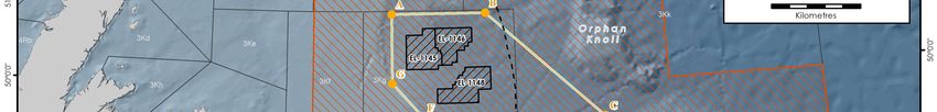
Newfoundland Orphan Basin Exploration Drilling Program

            3.3.7 Additional Ocean Infrastructure ................................................................................. 37
3.4         Existing Environmental Studies ............................................................................................. 40
4           Consultation and Engagement ............................................................................................... 41
4.1         Indigenous Engagement ......................................................................................................... 41
4.2         Stakeholder Engagement........................................................................................................ 44

            4.2.1 Government and Regulatory Stakeholders................................................................ 44
            4.2.2 Fisheries Stakeholders ................................................................................................ 44
            4.2.3 Other Public Stakeholder Groups ............................................................................... 45
4.3         Summary of Indigenous and Stakeholder Engagement to Date .......................................... 46
5           Potential Project-Related Changes to the Environment and Scoping Considerations ........ 44
5.1         Routine Project Activities ........................................................................................................ 55
5.2         Non-routine Project Activities ................................................................................................. 58
5.3         Scoping Considerations .......................................................................................................... 61
6           References ............................................................................................................................... 63

List of Appendices
Appendix A Table of Concordance with CEAA Regulation SOR 2012-148 and the Guide to
           Preparing a Description of a Designated Project under CEAA 2012 (March 2015)

List of Tables
Table 1  Licence Size and Interests ..................................................................................................... 1
Table 2  Project Area Coordinates ...................................................................................................... 8
Table 3  Species of Conservation Interest with Potential to Occur in the Project Area and in
         Surrounding Areas .............................................................................................................. 21
Table 4  Ecologically and Biologically Significant Areas within 150 km of the Project Area......... 24
Table 5  Vulnerable Marine Ecosystems within 150 km of the Project Area .................................. 26
Table 6  NAFO Fisheries Closure Areas within 150 km of the Project Area ................................... 26
Table 7  Commercial Communal Fishing Licences Issued to Newfoundland and Labrador
         Indigenous Groups in the Project Area and Surrounding Areas (NAFO Unit Areas
         3KLM) ................................................................................................................................... 29
Table 8  New Brunswick / Nova Scotia / Prince Edward Island / Quebec Indigenous Groups with
         Food, Social and Ceremonial (FSC) Fisheries Rights and/or Commercial Communal
         Swordfish Licences ............................................................................................................. 32
Table 9  Summary of Engagement to Date (December 31, 2017) ................................................... 47
Table 10 Potential Environmental Interactions with Routine Project Activities .............................. 55
Table 11 Potential Environmental Interactions with Accidents and Malfunctions during Project
         Activities .............................................................................................................................. 58

Project Description                                                                                                                         Page ii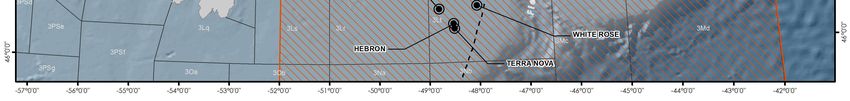
Newfoundland Orphan Basin Exploration Drilling Program
List of Figures
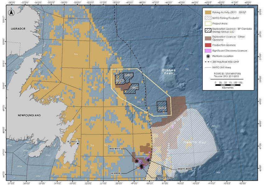
Figure 1 Location of Exploration Licences ....................................................................................... 2
Figure 2 BP’s Values.......................................................................................................................... 4
Figure 3 Project Area......................................................................................................................... 9
Figure 4 Schematic of Semi-submersible and Drillship................................................................ 10
Figure 5 Initial Drilling Sequence ................................................................................................... 11
Figure 6 Potential Vessel Transit Routes ....................................................................................... 14
Figure 7 Special Areas in the Eastern Newfoundland Offshore Area .......................................... 25
Figure 8 Commercial Fishing Activity in the Project Area and Surrounding Areas .................... 28
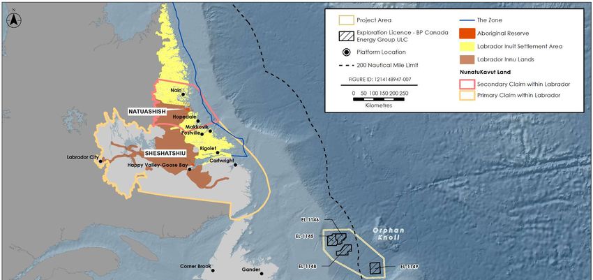
Figure 9 Indigenous Communities in Newfoundland and Labrador ............................................ 30
Figure 10 Indigenous Communities in New Brunswick, Nova Scotia, Prince Edward Island, and
Quebec ............................................................................................................................. 34
Figure 11 Common Vessel Traffic Routes in the Project Area and in Surrounding Areas ........... 36
Figure 12 Exploration Licences in the Newfoundland Offshore Area ........................................... 38
Figure 13 Locations of Known Shipwrecks, DND Legacy Sites, and Marine Subsea Cables in the
Project Area and in Surrounding Areas .......................................................................... 39
Figure 14 Cyclical Consultation and Engagement Process ............................................................ 41
Project Description Page iii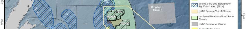
Newfoundland Orphan Basin Exploration Drilling Program

List of Acronyms

ADW                   Approval to Drill a Well
ASP                   Association of Seafood Producers
BOP                   blowout preventer
BP                    BP Canada Energy Group ULC
CAPP                  Canadian Association of Prawn Producers
CEA Agency            Canadian Environmental Assessment Agency
CEAA 2012             Canadian Environmental Assessment Act, 2012
CEPA                  Canadian Environmental Protection Act
C-NLOPB               Canada-Newfoundland and Labrador Offshore Petroleum Board
CNSOPB                Canada-Nova Scotia Offshore Petroleum Board
CO                    carbon monoxide
CO2                   carbon dioxide
CO2e                  carbon dioxide equivalent
COSEWIC               Committee on the Status of Endangered Wildlife in Canada
DFO                   Fisheries and Oceans Canada
DND                   Department of National Defence
DP                    dynamic positioning
EA                    environmental assessment
EBSA                  Ecologically and Biologically Significant Area
ECCC                  Environment and Climate Change Canada
EEZ                   Exclusive Economic Zone
EIS                   Environmental Impact Statement
EL                    Exploration Licence
FFAW-Unifor           Fish Food and Allied Workers-Unifor
FPSO                  floating, production, storage and offloading
FSC                   food, social and ceremonial
GEAC                  Groundfish Enterprise Allocation Council
GHG                   greenhouse gas
HSSE                  health, safety, security and environment
km                    kilometres
KMKNO                 Kwilmu’kw Maw-klusuaqn Negotiation Office
LISA                  Labrador Inuit Settlement Area
MARPOL                International Convention for the Prevention of Pollution from Ships
MCPEI                 Mi’kmaq Confederacy of Prince Edward Island

Project Description                                                                         Page iv
Newfoundland Orphan Basin Exploration Drilling Program

MFN                   Miawpukek First Nation
MMS                   Mi’gmawei Mawiomi Secretariat
MODU                  mobile offshore drilling unit
MPA                   Marine Protected Area
MTI                   Mi’gmawe’l Tplu’tagnn Inc.
NAFO                  North Atlantic Fisheries Organization
NB                    New Brunswick
NEB                   National Energy Board
NGO                   non-governmental organizations
NL                    Newfoundland and Labrador
nm                    nautical mile
NOx                   nitrogen oxides
NRCan                 Natural Resources Canada
NS                    Nova Scotia
OA                    Operations Authorization
OCI                   Ocean Choice International
OWTG                  Offshore Waste Treatment Guidelines
P&A                   plugged and abandoned
PEI                   Prince Edward Island
PL                    Production Licence
PM                    particulate matter
PSV                   platform supply vessel
QC                    Quebec
QMFNB                 Qalipu Mi’kmaq First Nation Band
ROV                   remotely operated vehicle
SARA                  Species at Risk Act
SBM                   synthetic-based mud
SDL                   Significant Discovery Licence
SEA                   Strategic Environmental Assessment
SO2                   sulphur dioxide
VME                   vulnerable marine ecosystem
VSP                   vertical seismic profiling
WBM                   water-based mud
WNNB                  Wolastoqey Nation of New Brunswick

Project Description                                           Page v
Newfoundland Orphan Basin Exploration Drilling Program
1 Introduction
BP Canada Energy Group ULC (BP) is proposing to conduct an exploration drilling program on
Exploration Licences (ELs) 1145, 1146, 1148, and 1149 in the Orphan Basin, located between 270
and 470 km east of the Island of Newfoundland, Canada (the Newfoundland Orphan Basin
Exploration Drilling Program; the Project). The Project may involve drilling up to 20 exploration
wells over the term of the ELs (2017 to 2026), with an initial well proposed to be drilled in 2019 or
2020 pending regulatory approval.
Offshore exploration drilling, under certain circumstances, is a designated activity under the
Canadian Environmental Assessment Act, 2012 (CEAA 2012). This document is a Project
Description, which is required to initiate a process to determine whether an environmental
assessment (EA) is required under CEAA 2012 and assist regulatory agencies, Indigenous
organizations, and stakeholders in identifying potential interests in the Project for consideration
during Project planning and the EA review process (as required).
1.1 Project Context and Objectives
On November 9, 2016, the Canada-Newfoundland and Labrador Offshore Petroleum Board
(C-NLOPB) announced BP and its co-venturers had been awarded exploration rights to ELs 1145,
1146, 1148, and 1149 with a work expenditure bid of $425,805,000. The term of these ELs extends
from January 15, 2017 to January 15, 2026, with the first term ending January 15, 2023. The
issuance of an EL confers the exclusive right to drill and test for petroleum within the ELs. BP is
required to drill one exploratory well on or before the expiry date of the first term of each licence
as a condition to maintaining tenure of the ELs for the second term.
BP shares these licences with co-venturers Hess Canada Oil and Gas ULC and Noble Energy
Canada ULC. BP will serve as the operator for the exploration drilling program. Table 1 shows the
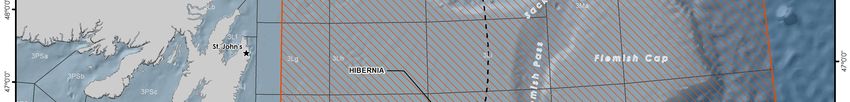
size and interests in each of the ELs. Figure 1 shows the location of the licences.
Table 1 Licence Size and Interests
EL Size Interest
1145 233,654 ha BP Canada Energy Group ULC (50%)
Hess Canada Oil and Gas ULC (25%)
Noble Energy Canada ULC (25%)
1146 192,807 ha BP Canada Energy Group ULC (50%)
Hess Canada Oil and Gas ULC (25%)
Noble Energy Canada ULC (25%)
1148 252,482 ha BP Canada Energy Group ULC (50%)
Hess Canada Oil and Gas ULC (25%)
Noble Energy Canada ULC (25%)
1149 164,249 ha BP Canada Energy Group ULC (60%)
Noble Energy Canada ULC (40%)
Project Description Page 1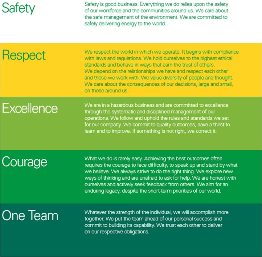
Newfoundland Orphan Basin Exploration Drilling Program

                                              Figure 1   Location of Exploration Licences

Project Description                                                                         Page 2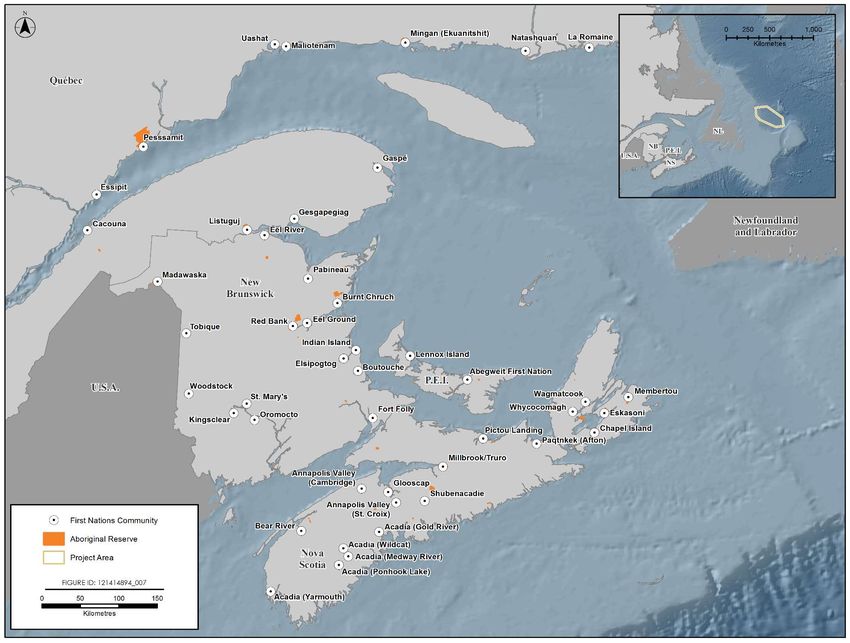
Newfoundland Orphan Basin Exploration Drilling Program

BP is proposing the exploration drilling program to determine the presence, nature, and quantities
of the potential hydrocarbon resource and to help BP fulfil its work expenditure commitments
over the term of the licences.

1.2    Proponent Information
BP is a global energy company, operating in almost 80 countries around the world, with well-
established operations in Europe, North and South America, Australasia, Asia, and Africa. BP has
decades of experience managing the extraction of oil and natural gas in all types of environments
around the world, both onshore and offshore. In Canada, BP focuses on developing energy from
Canada’s oil sands and is also pursuing offshore opportunities in Newfoundland and Nova Scotia.

Recognizing the need to work toward a lower carbon future, BP is evolving its energy strategy to
produce energy more efficiently and remain competitive in a time when prices, policy, technology,
and customer preferences are changing. One of these strategies involves investing in new large-
scale gas projects and pursuing quality oil projects in core basins. This proposed exploratory
program in the Orphan Basin is consistent with BP’s strategic priorities. BP also holds interests in
various licences in the Flemish Pass and Jeanne d’Arc Basin.

BP is dedicated to maintaining values of Safety, Respect, Excellence, Courage and One Team,
upholding these values internally and externally in the areas it operates. Figure 2 summarizes BP’s
values.

Project Description                                                                        Page 3
Newfoundland Orphan Basin Exploration Drilling Program

                                       Figure 2          BP’s Values

BP’s health, safety, security, and environment (HSSE) goals are: no accidents, no harm to people,
and no damage to the environment. Safety is at the heart of everything BP does as a company,
driven by leadership and applied across all operations throughout the operating management
system framework. Everyone who works for BP is responsible for his or her safety and the safety
of colleagues, partners, suppliers, and local communities.

BP has established an office in Halifax, Nova Scotia, to oversee its planned deep-water exploration
drilling offshore Nova Scotia. The proposed Scotian Basin Exploration Drilling Project involves
drilling an initial well in Q2 of 2018, pending regulatory approval. BP intends to establish a
physical presence in St. John’s, Newfoundland ahead of and during the proposed drilling
program, although preliminary planning is being conducted by BP staff based primarily in Halifax,
with technical resources drawn from BP’s Canadian headquarters in Calgary, Alberta, and BP’s
global operations in the United Kingdom and Houston, Texas.

All communications regarding the environmental assessment for the Project should be directed to
the following contacts:

Project Description                                                                       Page 4
Newfoundland Orphan Basin Exploration Drilling Program
BP Canada Energy Group ULC
Newfoundland Orphan Basin Exploration Drilling Program
Anita Perry BP Canada Energy Group ULC
Regional Manager, Atlantic Canada 10th floor, Founders Square
VP Communications and External Affairs Canada 1701 Hollis Street
Tel: (902) 420-2338 Halifax, NS B3J 3M8
anita.perry@bp.com Canada
Heather Giddens BP Canada Energy Group ULC
Environmental Impact Assessment Advisor 10th floor, Founders Square
Tel: (902) 420-2332 1701 Hollis Street
heather.giddens@bp.com Halifax, NS B3J 3M8
Canada
1.3 Regulatory Context
1.3.1 Accord Acts
Petroleum activities in the Newfoundland and Labrador (NL) offshore area are regulated by the
C-NLOPB, a joint federal-provincial agency reporting to the federal and provincial Ministers of
Natural Resources. In 1986, the Government of Canada and the Province of Newfoundland and
Labrador signed the Canada-Newfoundland and Labrador Offshore Petroleum Resource Accord to
promote social and economic benefits associated with petroleum exploitation. The federal and
provincial governments established mirror legislation to implement the Accord. The Canada-
Newfoundland and Labrador Atlantic Accord Implementation Act and the Canada-Newfoundland
and Labrador Atlantic Accord Implementation Newfoundland and Labrador Act are collectively
referred to as the Accord Acts.
Under the Accord Acts, the C-NLOPB issues licences for offshore exploration and development,
and is responsible for the management and conservation of offshore petroleum resources, and
protection of the environment, as well as the health and safety of offshore workers, while
enhancing employment and industrial benefits for Newfoundland and Labrador residents and
Canadians.
Offshore petroleum activities and the C-NLOPB’s decision-making processes are governed by a
variety of legislation, regulations, guidelines, and memoranda of understanding. Exploration
drilling programs require an Operations Authorization (OA) under the Accord Acts. Prior to issuing
an OA, the C-NLOPB requires the following to be submitted:
An Environmental Assessment Report
A Canada-Newfoundland and Labrador Benefits Plan
A Safety Plan
An Environmental Protection Plan (including a waste management plan)
Project Description Page 5Newfoundland Orphan Basin Exploration Drilling Program
Emergency Response and Spill Contingency Plans
Appropriate financial security
Appropriate certificates of fitness for the equipment proposed for use in the activities
For each well in the drilling program, a separate Approval to Drill a Well (ADW) is required. This
authorization process involves specific details about the drilling program and well design.
There are several regulations under the Accord Acts that govern specific exploration or
development activities. There are also various guidelines, some of which have been jointly
developed with the Canada-Nova Scotia Offshore Petroleum Board (CNSOPB) and National
Energy Board (NEB), which are intended to address environmental, health, safety, and economic
aspects of offshore petroleum exploration and development activities. Of particular relevance to
the EA of this Project are the Drilling and Production Guidelines (C-NLOPB and CNSOPB 2017), the
Offshore Waste Treatment Guidelines (OWTG) (NEB et al. 2010) and the Offshore Chemical
Selection Guidelines for Drilling and Production Activities on Frontier Lands (NEB et al. 2009).
1.3.2 Environmental Assessment
Offshore exploration drilling, under certain circumstances, is a designated physical activity subject
to the requirements of the CEAA 2012. Section 10 of the Regulations Designating Physical
Activities under CEAA 2012 includes:
The drilling, testing and abandonment of offshore exploratory wells in the first drilling
program in an area set out in one or more exploration licences issued in accordance with
the Canada-Newfoundland Atlantic Accord Implementation Act or the Canada-Nova Scotia
Petroleum Resources Accord Implementation Act.
The Project will constitute the first drilling, testing, and abandonment of offshore exploratory
wells within the ELs issued to BP by the C-NLOPB. Following submission of this Project
Description document, the Canadian Environmental Assessment Agency (CEA Agency) will
conduct a screening process and determine the requirement for an EA under CEAA 2012. Should a
federal EA process be required under CEAA 2012, it is expected that an Environmental Impact
Statement (EIS) will be required and that the EIS will also satisfy the C-NLOPB requirements for an
EA as part of the OA review process under the Accord Acts. Should a federal EA process not be
required under CEAA 2012, BP will still prepare an EA Report to satisfy C-NLOPB requirements as
part of the OA review process.
1.3.3 Other Regulatory Requirements and Interests
As defined by the Accord Acts, the Newfoundland and Labrador offshore area regulated by the C-
NLOPB includes the greater of lands within Canada’s 200 nautical mile (nm) Exclusive Economic
Zone (EEZ) or to the edge of the continental margin. CEAA 2012 defines federal lands as those
lands that include the continental shelf of Canada. Therefore, the Project will be carried out on
federal lands under the jurisdiction of the C-NLOPB. There is no federal funding involved in this
Project.
Project Description Page 6Newfoundland Orphan Basin Exploration Drilling Program In addition to the OA and ADW from the C-NLOPB pursuant to the Accord Acts, and EA approval under CEAA 2012 (if required), the Project is subject to various federal legislative and regulatory requirements, including: Canada Shipping Act Canadian Environmental Protection Act, 1999 Fisheries Act Migratory Birds Convention Act, 1994 Species at Risk Act (SARA) Navigation Protection Act A Migratory Bird Handling Permit will likely be required from Environment and Climate Change Canada (ECCC) to permit the salvage of stranded birds on offshore vessels during the Project. A provincial EA under the Environmental Protection Act is not anticipated to be required based on the proposed Project scope. BP will not be constructing onshore facilities as part of the Project. No provincial or municipal permits are currently anticipated to be required for the Project, including for the onshore supply base which will be sited at an existing facility. There are two offshore supply bases on the east coast of the Island of Newfoundland, which have been providing support to offshore oil and gas activity in the Newfoundland offshore since the early 1990s. These are third-party facilities that have the necessary permits and approvals to undertake activities related to offshore oil and gas projects. No additional modifications or changes to the existing third-party supply base will be required for the purpose of supporting this Project. As a result of the forgoing, the supply base and associated activities are not considered to be within the scope of the Project assessment. Project Description Page 7
Newfoundland Orphan Basin Exploration Drilling Program
2 Project Description
2.1 Project Location
BP proposes to drill up to 20 exploration wells on ELs 1145, 1146, 1148, and 1149 during the
term of the ELs. The ELs are located in the Grand Banks Region, with ELs 1145, 1146, and 1148
located in the West Orphan Basin within Canada’s 200 nm EEZ, and EL 1149 located in the East
Orphan Basin, beyond the EEZ. These ELs are between approximately 270 and 470 km east of
the Island of Newfoundland. The ELs are approximately 350 km from St. John’s; the nearest
community is Elliston (approximately 280 km), on the Bonavista Peninsula. The nearest
“residences” to the Project Area would be the SeaRose floating, production, storage and
offloading (FPSO) vessel at Husky’s White Rose oil development field, approximately 250 km
from EL 1149. Water depths in these ELs range from approximately 1,000 to 3,000 m. Specific
well sites are not yet known but drilling operations will be conducted within the defined
boundaries of ELs 1145, 1146, 1148, or 1149.
A Project Area has been proposed that encompasses the four ELs and incorporates an
approximate 20 km buffer. Further direction on setting spatial boundaries may be provided in
the EIS Guidelines, should it be determined that a federal EA process under CEAA 2012 is
required. The EIS would define study area boundaries that will extend beyond the Project Area
based on potential environmental interactions with routine and unplanned Project activities
and in recognition of potential cumulative environmental effects. Project Area coordinates are
provided in Table 2; the Project Area is shown on Figure 3.
Table 2 Project Area Coordinates
WGS 84 NAD83 UTM ZONE22N
Vertex Label
X Y X Y
A 50° 25' 55.634" W 50° 57' 47.150" N 539879.34 5645874.69
B 48° 33' 55.067" W 50° 57' 47.112" N 670967.10 5648542.28
C 46° 17' 33.285" W 49° 35' 59.349" N 840097.99 5504788.98
D 46° 19' 24.131" W 48° 46' 12.260" N 843582.30 5412452.89
E 47° 32' 58.040" W 48° 46' 12.260" N 753521.20 5407640.85
F 49° 49' 41.068" W 49° 39' 12.035" N 584589.89 5500748.33
G 50° 25' 55.634" W 50° 50' 12.038" N 540624.92 5548422.36
There are no zoning designations that apply to the Project Area. The Project will not take place
on lands that have been subject to a regional study as described in Sections 73-77 of CEAA
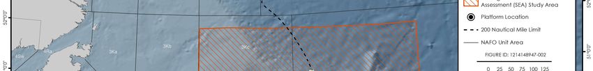
2012; however, the Project Area falls within the study area for the Eastern Newfoundland
Strategic Environmental Assessment (SEA) completed by the C-NLOPB in August 2014 (AMEC
2014) (refer to Figure 3).
Project Description Page 8Newfoundland Orphan Basin Exploration Drilling Program
Figure 3 Project Area
Project Description Page 9Newfoundland Orphan Basin Exploration Drilling Program
2.2 Project Components and Activities
2.2.1 Drilling
Wells will be drilled using either a semi-submersible rig or a drillship, referred to generically as a
mobile offshore drilling unit (MODU). The MODU will be procured by BP through a competitive
bid process in accordance with the requirements of the Accord Acts. It is possible that the same
MODU may not be used for drilling all wells in the drilling program. A semi-submersible rig would
either be moored in position over the drilling site, or, as is more likely for this drilling program,
maintained on station by dynamic positioning (DP). A drillship would maintain its position by DP.
The standard mooring technique for a semi-submersible is an eight-point spread mooring
arrangement using a combination of wire rope, chains, and anchors. The anchors are set in a pre-
determined pattern using an anchor handling offshore vessel. In the DP mode, a semi-submersible
or drillship maintains position using thrusters positioned on the hulls, which are controlled by a
computerized positioning system. Figure 4 shows a schematic of a semi-submersible rig using
mooring (rather than DP) and a drillship for comparison purposes.
Source: Adapted from MMS 2000
Figure 4 Schematic of Semi-submersible and Drillship
Prior to drilling, proposed wellsite locations are surveyed, generally using a remotely operated
vehicle (ROV) to inspect the seabed for potential hazards and sensitive habitat (e.g., habitat-
forming corals).
The drilling of an offshore well can be broken down into two phases: riserless drilling and riser
drilling. Drilling fluid can be a water-based mud (WBM) or synthetic-based mud (SBM) suspension
of clays and is used in well drilling to help equalize pressure, keep the drill bit cool, and flush out
cuttings from the wellbore. The initial (i.e., surface) sections are normally drilled without a riser
system, which serves as a conduit to bring mud and cuttings back to the drilling vessel in a closed
loop system. These “riserless” sections are drilled using a WBM, with mud and cuttings returned
to the seabed as permitted by the OWTG.
Project Description Page 10Newfoundland Orphan Basin Exploration Drilling Program
The well design has not yet been completed. In general, following the drilling of the initial
sections, the drill string (assembly of drill pipes) is removed and a steel casing is cemented into
place to prevent the wall of the well from caving in and prevent seepage of muds and other fluids.
The casing also provides adequate pressure integrity to allow a blowout preventer (BOP) and riser
system to be installed. The BOP is a critical piece of safety equipment which, in the event of an
emergency or equipment failure, allows the wellbore to be closed, thereby preventing
hydrocarbons from escaping the wellbore into the environment.
Once a riser system has been installed, the deeper (lower hole) sections of the wells may be
drilled with SBM. The riser returns mud and cuttings to the drilling vessel in a closed loop system
for treatment prior to disposal to the seabed in accordance with the OWTG. More information on
the management of drilling waste is provided in Section 2.3.3. An unplanned or planned side-track
(i.e., drilling a second wellbore away from an original wellbore) may be drilled to meet the Project
objectives. Figure 5 presents a schematic demonstrating the initial drilling sequence of a well.
Figure 5 Initial Drilling Sequence
BP proposes to commence drilling in 2019 or 2020, pending regulatory approval. Depending on
the results of the initial well, up to 20 wells may be drilled over the term of the ELs. It is anticipated
that it will take approximately 60 days to drill each well.
Project Description Page 11Newfoundland Orphan Basin Exploration Drilling Program
2.2.2 Vertical Seismic Profiling
Following the drilling of each well to its target depth (where hydrocarbon reservoirs are predicted
to be located), vertical seismic profiling (VSP) is conducted to obtain accurate “time to depth ties”,
which allows the correlation of seismic data (which is recorded in time measurements) to well
depth (recorded in metres (m)). VSP operations involve deploying an acoustic sound source from
the drilling or support vessel, while a number of receivers are positioned at different levels within
the drilled hole to measure the travel time.
Typically, between three and six sound sources are used, with a volume of 150 to 250 cubic inches
each, although there could be up to 12 sound sources in a larger array. These sound sources are
generally positioned at 5 to 10 m water depth. VSP operations are typically of short duration,
taking approximately one to three days to complete for each well. Specific details of the VSP
program will depend on the geological target and the objectives of the VSP operation.
2.2.3 Well Evaluation and Testing
If exploration drilling results indicate the potential presence of hydrocarbons, the well will be
evaluated and possibly tested to provide further information. Well evaluation is an important
component of exploration drilling as it helps to determine the viability of a prospect and
commercial potential of the reservoir. If a well test is required, it will be subject to BP’s well test
assurance process, which is designed to promote safe and efficient well test operations. In line
with industry practice, well flow testing involves flowing the well fluids through temporary test
equipment located on the drilling vessel, and requires flaring of gases or other hydrocarbons that
come to surface for safe disposal.
Flaring activity will be carried out in accordance with industry standard and applicable regulations.
It is anticipated that testing would occur over a one to three-month period after drilling is
complete. As part of any well test program, there are likely to be separate periods of flaring that
may comprise the following activities:
A number of main flow test periods each involving approximately 24 hours of flaring for any
one period
Other flaring periods for operational purposes including flushing and/or bleeding off surface
equipment (these periods are likely to last between one and six hours each and the flow rates
during these periods are expected to be small)
2.2.4 Well Abandonment
All wells drilled in the drilling campaign will likely be permanently plugged and abandoned (P&A)
after completion of data acquisition and evaluation programs, in accordance with BP
recommended practice and any applicable regulations. Depending on the results of the well, it
may be suspended and re-entered for additional data acquisition and evaluation before final P&A.
Suspension and P&A procedures are designed to isolate the well and prevent the release of
wellbore fluids to the marine environment.
Project Description Page 12Newfoundland Orphan Basin Exploration Drilling Program P&A operations involve setting a series of cement and mechanical plugs within the wellbore, including plugs above any hydrocarbon-bearing intervals, at appropriate barrier depths in the well, and at the surface. A seabed survey is typically conducted for each well using an ROV to survey the seabed for debris. 2.2.5 Supply and Servicing Offshore drilling operations will be supported by logistics arrangements for supply and servicing activity. Such arrangements will allow the transportation and movement of equipment and personnel between the MODU and land, and will allow sufficient stocks of equipment and supplies to be maintained for reliable, ongoing drilling operations. Existing facilities in eastern Newfoundland will be used for supply, support, and logistical functions. These shore-based facilities are owned and operated by independent third-party service providers and currently service multiple operators and their activities. They are also certified as compliant port facilities under the Marine Transportation Security Act. Third-party services and support will be procured through a competitive bid process in accordance with the requirements of the Accord Acts. The Project will not require the development of new infrastructure or any upgrades to existing facilities to support Project operations. Third-party service providers will be responsible for maintaining applicable regulatory approvals to operate their facilities. It is likely that two to three platform supply vessels (PSVs) will be required, with one vessel on stand-by at the MODU at all times. It is estimated that the PSVs will make a total of two to three round trips per week between the MODU and the supply base during the course of drilling each well. Existing shipping lanes will be used as practicable to reduce incremental marine disturbance. Where these do not exist, PSVs will follow a straight-line approach to and from port to the Project Area (refer to Figure 6). Once in the Project Area, the PSV will select the most appropriate route for reaching the destination. The PSVs will follow applicable Port Authority requirements when in a port and will be compliant with the Eastern Canadian Vessel Traffic Services Zone Regulations when operating in near-shore or harbour areas. PSV transit has an existing regulatory regime and best management practices and is an ongoing, routine activity among all operators in the region. Aircraft (helicopter) support for the Project will be based at the St. John’s International Airport. Helicopters will be used for crew changes on a routine basis and to support medical evacuation from the MODU and search and rescue activities in the area, if required. It is estimated that approximately two helicopter trips per day may be required to transfer crew and any supplies not carried by the PSV to the MODU. The MODU will be equipped with a helideck for safe landings. Project Description Page 13
Newfoundland Orphan Basin Exploration Drilling Program

                                               Figure 6   Potential Vessel Transit Routes

Project Description                                                                         Page 14
Newfoundland Orphan Basin Exploration Drilling Program 2.3 Emissions, Discharges, and Waste Management Efforts will be made to reduce waste emissions and discharges generated during the Project. All waste generated will be managed and disposed according to regulatory requirements and applicable guidelines. Offshore waste discharges will be managed in compliance with the International Convention for the Prevention of Pollution from Ships (MARPOL) and/or the OWTG, as applicable. Wastes brought to shore for disposal will be managed in accordance with the Newfoundland and Labrador Waste Management Strategy and other applicable regulatory requirements (including municipal by-laws). A Waste Management Plan will be prepared as part of the OA application process with the C-NLOPB prior to drilling operations. The following subsections provide a general description of typical wastes to be generated over the course of Project activities and how these wastes will be managed. 2.3.1 Atmospheric Emissions Atmospheric emissions expected to be associated with Project activities are primarily related to the combustion of marine fuel by the drilling vessel and PSVs. Emissions are also associated with short-term flaring during well testing, if testing is performed. These emissions will include carbon monoxide (CO), carbon dioxide (CO2), sulphur dioxide (SO2), nitrogen oxides (NOx), and particulate matter (PM). BP will comply with the provincial Air Pollution Control Regulations, Ambient Air Quality Objectives under CEPA, regulations under MARPOL and the intent of the Global Gas Flaring Reduction Partnership (which seeks to increase the use of associated natural gas and thus reduce flaring and venting). With respect to greenhouse gas (GHG) emissions, it is estimated that there could be approximately 300 tonnes of carbon dioxide equivalent (CO 2e) emissions associated with operational drilling and vessel traffic per day or approximately 18,000 tonnes CO 2e per well, assuming a 60-day drilling program. Assuming that there could be between zero to three wells drilled per year over the term of the ELs, annual GHG emissions resulting from the Project are estimated to be up to approximately 54,000 tonnes CO2e. These emissions represent 1.10% of the total reported provincial GHG emissions for 2015 (4,924,713 tonnes CO 2e) and 0.01% of the national emissions (264,163,368 tones CO2e) (ECCC 2017). If well flow testing is conducted, flaring will result in additional GHG emissions. Assuming approximately four well flow testing events over the life of the Project (one target tested per EL), it is estimated that an additional 17,448 tonnes of CO2e could be emitted. Artificial light emissions associated with the Project include navigation and deck lighting from the MODU and PSVs. Artificial lighting will be reduced to the extent that it does not affect worker and vessel safety. In the event of flaring during well testing, there will be temporary (e.g., up to two or three days) light and thermal emissions associated with the flare. Atmospheric sound will be generated by the MODU, PSVs, and helicopter traffic. However, there is limited predicted interaction with human receptors given the distance of the MODU offshore and that the PSVs and helicopter will operate out of existing port and airport facilities. The sound generated by Project traffic will be comparable to existing vessel and helicopter traffic. Underwater sound is discussed in Section 2.3.2. Project Description Page 15
Newfoundland Orphan Basin Exploration Drilling Program

2.3.2 Underwater Sound
Underwater sound is generated by the MODU and PSVs as well as during VSP operations. The
level of underwater sound generated is influenced by the type of drilling vessel (e.g., semi-
submersible versus drillship) and method of positioning on station (e.g., use of thrusters for
dynamic positioning versus anchoring). The propagation of underwater sound with distance from
a source is influenced by water column and seabed characteristics. Underwater sound associated
with the MODU is continuous during a drilling program. Underwater sound generated during VSP
operations is impulsive, with higher sound level pulses occurring over of a much shorter duration
(up to approximately three days, depending on the VSP method selected).

2.3.3 Drilling Waste
The initial (i.e., surface) sections are normally drilled riserless with WBM, with mud and cuttings
returned to the seabed where they will accumulate near the wellhead. The discharge of WBM
cuttings at the seabed, while drilling the first two hole sections, is accepted as industry standard
practice and is consistent with the OWTG. Spent and excess WBM may be discharged from the
drilling vessel without treatment as per the OWTG. The deeper (lower hole) sections of the wells
will likely be drilled with SBM. The marine riser located between the BOP and the drilling vessel
acts as a conduit for the return of drilling mud and cuttings back to the drilling vessel for
treatment prior to disposal to the seabed in accordance with the OWTG.

On the drilling vessel, the drilled cuttings and drilling mud are separated and cleaned using solids
control equipment. The mud returns carrying the drilled cuttings initially pass through a shale
shaker, where the majority of mud is separated from the cuttings. Where SBM is used, cuttings
from the shale shaker pass through a cuttings dryer, which removes SBM from cuttings. Residual
synthetics-on-cuttings discharged to the marine environment is treated in accordance with the
OWTG prior to discharge. Monitoring of the residual base mud-on-cuttings levels is carried out
during well sections involving use of SBM. After recovery and treatment of drill muds, the drill
cuttings are discharged from the drilling vessel at the well site. No surplus SBM is discharged to
the sea; spent SBM that cannot be reused during drilling is brought to shore for disposal in an
approved licensed facility.

The extent of drilling discharge deposition can only be predicted accurately through a drilling
discharge dispersion modelling exercise, which will be carried out as part of the EIS. The zone of
deposition would depend on the particle size distribution in the discharge stream, water depth,
and currents. The depositional thickness will vary by water depth and is likely to be greater during
the riserless drilling associated with the upper well section, as WBM cuttings are released directly
at the seafloor, which limits the likelihood of cuttings distribution through the water column.

Cement is used to set the well casing strings during drilling. Prior to installation of the riser
package (e.g., during drilling of the conductor and surface holes), surplus cement is discharged at
the seafloor. Following installation of the riser, residual cement associated with drill cuttings and
flushing of cement lines/tanks is discharged from the drilling vessel in accordance with industry
practice. Surplus cement is brought to shore for disposal in an approved facility.

Project Description                                                                         Page 16
Newfoundland Orphan Basin Exploration Drilling Program If a well test is deemed necessary, the wellbore fluids (gas and liquid phases) will be managed in accordance with industry standard practice and any applicable regulations. 2.3.4 Liquid Discharges A number of liquid wastes could be generated from the MODU and/or the PSVs including: Produced water Bilge and deck drainage water Ballast water Grey / black water (sewage) Cooling water Well treatment fluids Fire control testing water BOP fluid The OWTG contain performance targets for each of these discharges, including in some cases, required sampling and analysis prior to ocean discharge. Where discharges occur offshore, the points of discharge will be below the water surface. Liquid discharges that do not meet OWTG performance targets for ocean disposal are transported to shore for disposal at an approved licensed disposal facility. 2.3.5 Hazardous and Non-Hazardous Solid Wastes Hazardous and non-hazardous solid wastes will also be generated by Project activities. Food wastes will be macerated in accordance with the OWTG prior to discharge at sea (below the water surface). All other solid waste generated offshore will be transported to shore for appropriate treatment and/or disposal in accordance with applicable regulations and municipal by-laws. Non- hazardous wastes may include domestic waste, scrap metal, recyclables, and other miscellaneous non-hazardous wastes. Hazardous wastes (including waste dangerous goods) could include oily waste (filters, rags, waste oil), waste chemicals and containers, batteries, and biomedical waste. BP will retain a third-party licensed waste management contractor to manage and dispose of wastes transported onshore. Hazardous wastes will be disposed of at approved facilities in compliance with applicable regulations and approvals. 2.4 Project Schedule BP proposes to commence exploration drilling with an initial well in 2019 or 2020 pending regulatory approval to proceed. Up to 20 exploration wells could be drilled over the term of the ELs (2017 to 2026) contingent on the drilling results of the initial well. Drilling activities will not be continuous and will be in part determined by rig availability and previous wells’ results. It is anticipated that each well will take approximately 60 days to drill. BP’s preference is to conduct drilling between May and October, although the EIS (if required under CEAA 2012) will assume year-round drilling. VSP operations will take approximately one to three days per well and well testing, where required, would occur over a one to three-month Project Description Page 17
Newfoundland Orphan Basin Exploration Drilling Program

period. Well abandonment will likely be conducted following drilling and/or well flow testing.
Wells may be designed for suspension and re-entry but this will be determined through further
prospect evaluation.

2.5    Potential Accidental Events
BP uses a systematic process to identify and manage potential risks and unplanned events that
could occur during its global activities. Multiple preventative and response barriers are put in
place to manage risk, both in terms of the incident arising in the first place, and to mitigate and
respond to incidents to manage potential consequences. Potential accidental events that could
occur during exploration drilling and potentially result in a release to the environment, include
vessel collision, dropped objects, loss of well control (e.g., blowout), and spills and releases from
MODU or PSVs.

BP will conduct predictive spill modelling to help assess the risk of adverse environmental effects
that might occur as a result of potential accidental events associated with the Project. Oil spill
modelling will take into consideration the water depth and metocean conditions within the
proposed drilling area, which would affect the behaviour of a subsea spill scenario. In general,
because hydrocarbons released from a subsea spill in deep water would remain in the water
column longer as it rose to the surface, the hydrocarbon would be subject to a greater degree of
mixing, dissolution and natural dispersion than a subsea release in shallow water. A deep-water
release would, therefore, be more likely to be transported by subsea currents and subject to
spreading over a larger area than a shallow water release.

The EIS (if required under CEAA 2012) will also provide an overview of BP’s overall oil spill
preparedness and response capability which will include a range of specific response measures
such as offshore containment and recovery, chemical dispersant use, in situ burning, shoreline
protection and oiled wildlife response.

Project Description                                                                         Page 18
Newfoundland Orphan Basin Exploration Drilling Program

3     Environmental Setting
3.1    Physical Environment

3.1.1 Geology and Topography
The geology of the Eastern Newfoundland offshore area is complex and dynamic, and the current
bedrock and surficial characteristics of the area have been shaped by various natural and human
factors and processes over time (AMEC 2014). The eastern continental shelf was formed by
extension during the breakup of Pangea and the opening of the Atlantic Ocean during the Late
Triassic to Mid-Cretaceous, and is underlain by pre-rift basement rocks (Fader et al. 1989). A
combination of rifting and salt tectonics in the area created a series of Mesozoic rift basins. The
main sedimentary basins in the area include the Orphan, Flemish Pass, Jeanne d’Arc, and Carson
basins (Fader et al. 1989).

The topography of Orphan Basin and surrounding areas includes at least four distinct types
characterized by depth, location, and physiography (LGL 2003a, in LGL 2011a). These include: the
eastern portion of the northeast Newfoundland Shelf (depths ≤200m); the northeast
Newfoundland Shelf Slope (depths >200 to 2,000 m); the Orphan Basin proper (depths 2,000 to
>3,000 m); and the Flemish Pass (depths >1000 m) (LGL 2003a, in LGL 2011a). Surficial sediment in
this area ranges from fine muds and clays to extremely coarse boulders and bedrock (LGL 2011a).

The combination of stratigraphy, structure, and timing have been conducive to hydrocarbon
generation and entrapment in the area (Bell and Campbell 1990). The primary reservoirs in the
East Orphan basin are the shallow fluvial sandstones deposited during the Late Jurassic and Early
Cretaceous periods of the Mesozoic Era. The primary exploration targets in the West Orphan basin
are lower Tertiary basin floor fan sandstone reservoirs.

3.1.2 Climate
The area between the northern Grand Banks and the Orphan Knoll experiences weather
conditions typical of a marine climate, including reduced visibilities, low cloud heights, and
significant amounts of precipitation (LGL 2011a). The surrounding waters have a moderating
effect on temperature, and in general, summers are cooler and winters are warmer than those in
continental climates (LGL 2011a). Air temperatures in the Orphan Basin exhibit strong seasonal
variations, with mean temperatures ranging from -2.9°C in February to 11.7°C in August (AMEC
2014). Throughout the year, the mean daily minimum and maximum temperatures generally
range within approximately 3°C of the mean temperature (AMEC 2014).

The climate of the Project Area is dynamic and is largely controlled by the passage of high and
low circulation systems. There is a prevailing westerly flow, typical of the upper layers of the
atmosphere in the mid-latitudes, due to the normal tropical-to-polar temperature gradient (LGL
2011a). The mean strength of this westerly flow is stronger in winter months than during the
summer months (LGL 2011a).

In the Orphan Basin, most of the observed precipitation events are in the form of rain and snow,
while other precipitation types, such as mixed rain and snow, freezing rain, and hail, occur far less

Project Description                                                                        Page 19
Newfoundland Orphan Basin Exploration Drilling Program

frequently (AMEC 2014). The monthly frequency of rain events is lowest in January and February,
when the frequency of snow events is at its peak (AMEC 2014). The monthly frequency of rain
events is at its highest between the months of May and November, with maximum rain frequency
in October, and the lowest frequency of snow events from June to September (AMEC 2014).

The Orphan Basin and Grand Bank areas experience seasonal sea or pack ice from January to
April, with the maximum southern extent occurring from February to the middle of March (AMEC
2014). The Flemish Pass and Tail of the Grand Banks areas rarely experience sea ice (typically one
or two weeks in mid-March when it is present) (LGL 2010; AMEC 2014). Icebergs can occur in the
Orphan Basin, Grand Bank, and Flemish Pass areas from February to July, especially in the region
nearest the Grand Banks (AMEC 2014); large icebergs are rarely seen in the Tail of the Grand
Banks area (LGL 2010).

3.1.3 Ocean Currents
Large scale circulation off the coast of Newfoundland and Labrador is dominated by well-
established currents that flow along the margins of the Continental Shelf (LGL 2011a). The two
major current systems in the area are the Labrador Current and the North Atlantic Current
(Colbourne and Foote 2000, in LGL 2011a). The main current in the Project Area is the Labrador
Current which transports sub-polar water to lower latitudes along the Continental Shelf of Eastern
Canada.

Within the Project Area, and in surrounding areas, the largest seas are typically found farthest
offshore, usually during the winter season between the months of December and January (AMEC
2014). In the Orphan Basin, mean significant wave heights range from 1.7 m in July to 4.3 m in
January, with maximum significant wave heights ranging from 6.3 m in July to 15.9 m in January
(AMEC 2014). Significant wave heights exceeding 6 m are expected to occur during every month
of the year (AMEC 2014).

3.1.4 Air Quality
Air Quality within the Project Area, and in surrounding areas, is anticipated to be good, with
occasional exposure to exhaust products from PSVs, other marine traffic, helicopters, and existing
offshore oil production facilities in the Jeanne d’Arc Basin (Hibernia, Terra Nova, White Rose, and
Hebron). The general area also receives long-range contaminants from the Northeast Seaboard
and industrial midwest of the United States (ExxonMobil Canada Properties 2011, in Husky 2012).

3.2    Biological Environment

3.2.1 Fish, Fish Habitat, and Aquatic Species
The eastern Newfoundland offshore area is a highly-productive ecosystem and there are many
species of fish, marine mammals, sea turtles, and marine birds that occur, or could potentially
occur, in the Project Area. Some of these species are listed as species at risk under SARA and / or
are identified as species of conservation interest by the Committee on the Status of Endangered
Wildlife in Canada (COSEWIC). There are currently 32 species of conservation interest (i.e., listed
by SARA or assessed by COSEWIC) that could occur within the Project Area. Of these, there are 22

Project Description                                                                      Page 20
You can also read