L ittle Desert National Park - Management Plan June1996 - NATURAL RESOURCES AND ENVIRONMENT
←
→
Page content transcription
If your browser does not render page correctly, please read the page content below
National Parks Service

L ittle Desert National Park
Management Plan

June1996

NATURAL RESOURCES
AND ENVIRONMENT
This Management Plan for the Little Desert National Park is approved for implementation. Its purpose
is to direct all aspects of management in the Park until the Plan is reviewed. A Proposed Management
Plan for the Little Desert National Park and Wail State Forest was published in November 1991. A
total of 179 submissions on the Proposed Plan were received from private individuals and groups.

Copies of this Plan can be obtained from:
        NRE Horsham Office
        Department of Natural Resources and Environment
        21 McLachlan Street
        HORSHAM VIC 3400

        Outdoors Information Centre
        Department of Natural Resources and Environment
        240 Victoria Parade
        EAST MELBOURNE VIC 3002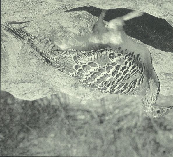
LITTLE DESERT NATIONAL PARK

    MANAGEMENT PLAN

                           National Parks Service

                       DEPARTMENT OF NATURAL
                   RESOURCES AND ENVIRONMENT

                                       VICTORIA

                                      JUNE 1996
© Crown (State of Victoria) 1996
A Victorian Government Publication
This publication is copyright.
No part may be reproduced by any process except in accordance with the provisions of the Copyright
Act 1986.
Published June 1996 by the Department of Natural Resources and Environment
240 Victoria Parade East Melbourne 3002 Victoria.
National Library of Australia
Cataloguing-in-Publication entry
Victoria. National Parks Service.
Little Desert National Park management plan.
Bibliography.
ISBN 0 7306 6173 3.
1. National parks and reserves - Victoria - Management.
2. Little Desert National Park (Vic.). I. Victoria.
Dept. of Natural Resources and Environment. II. Title.
333.783099458
Note: In April 1996 the Department of Conservation and Natural Resources (CNR) became part of the
Department of Natural Resources and Environment (NRE).
COVER: Malleefowl, a significant species in the Park, is classified as ‘vulnerable’ in Victoria.
Printed on 100% recycled paper to help save our natural environment.
ii Little Desert National ParkFOREWORD
The Little Desert National Park is renowned for The public consultation process has included
its unmodified ‘desert’ landscapes and its four public meetings, 179 formal submissions
conservation values. Features of special note following the release of a Proposed Plan. All
include the presence of Malleefowl, the comments have been carefully considered in the
Wimmera River and colourful spring preparation of this Plan.
wildflower displays.
The Little Desert National Park will be
Although not an immediately spectacular managed to conserve the Park’s rich and
national park like the Grampians or Wilsons diverse assemblage of flora and fauna and
Promontory, Little Desert National Park has a protect other important natural values.
subtlety and surprising variety that many Recreational opportunities will be enhanced to
people value very highly. For those who look help people appreciate and enjoy the Park’s
closely the Park challenges all notions of desert values.
as wasteland.
Over a number of years there has been very
strong public interest in the management of this
area.
Hon Marie Tehan MP
MINISTER FOR CONSERVATION
and LAND MANAGEMENT
Little Desert National Park iiiAPPROVED MANAGEMENT PLAN
This Approved Management Plan, prepared The Plan provides the basis for future
under Section 17 of the National Parks Act management of the Little Desert National Park.
1975 (Vic.), is approved for implementation. It was finalised following consideration of the
179 submissions received on the Proposed Plan.
Mark Stone Paul Mainey
Director, National Parks Service Interim Regional Manager, South West
iv Little Desert National ParkSUMMARY
Little Desert National Park (132 000 ha) • Fire protection will be managed in
protects significant vegetation and habitats accordance with the Horsham Region Fire
characteristic of relatively low rainfall and soils Protection Plan and a Park fire
of low natural fertility. management plan, which will integrate
The Park’s diverse and significant flora and burning for fire protection and ecological
fauna give the area outstanding conservation purposes.
values. • Control of foxes, rabbits and pest plants,
Little Desert National Park will be managed as in conjunction with adjacent landholders
a world-class protected area for conservation where appropriate, will be a priority.
and recreation consistent with its national park • Camping and day visitor facilities in
status. Protecting and enhancing the Park’s several locations along the Wimmera
largely undisturbed environments will be an River and elsewhere in the Park will be
important management goal. maintained or upgraded.
Recreational opportunities will be retained or • The range of walking opportunities will be
enhanced, and the Park will continue to make enhanced and promoted, particularly the
an important contribution to nature-based Desert Discovery Walk.
tourism in western Victoria.
• Four wheel driving opportunities will be
Significant management directions for the Park maintained, with difficult and/or sensitive
are summarised below. sections of tracks being upgraded or
• Significant vegetation and habitats will be realigned.
given special protection. Priorities include
Malleefowl habitats, Yellow Gum
woodlands in the western block and the
Wimmera Heritage River corridor.
Little Desert National Park vvi Little Desert National Park
CONTENTS

      FOREWORD                                                               iii

      SUMMARY                                                                 v

      1        INTRODUCTION                                                   1

               1.1       Location and planning area                           1
               1.2       Regional context                                     1
               1.3       Significance of the Park                             1
               1.4       Creation of the Park                                 2
               1.5       Legislation, LCC recommendations and guidelines      2
               1.6       Park management aims                                 3

      2        STRATEGIC DIRECTIONS                                           4

               2.1       Park vision                                          4
               2.2       Management directions                                4
               2.3       Zoning                                               5

      3        RESOURCE CONSERVATION                                          8

               3.1       Geological and landform features                     8
               3.2       Rivers and streams                                   8
               3.3       Vegetation                                           9
               3.4       Fauna                                               11
               3.5       Landscape                                           14
               3.6       Cultural heritage                                   14

      4        PARK PROTECTION                                               18

               4.1       Fire management                                     18
               4.2       Pest plants and animals, and diseases               19
               4.3       Soil conservation                                   22

      5        THE PARK VISIT                                                23

               5.1       The Park visitor                                    23
               5.2       Visitor recreation activities and facilities        24
                         5.2.1     Vehicle access                            24
                         5.2.2     Bicycling                                 28
                         5.2.3     Picnicking and camping                    28
                         5.2.4     Bushwalking                               29
                         5.2.5     Horse riding                              30
                         5.2.6     Boating, water-skiing and swimming        30
                         5.2.7     Fishing and yabbying                      32
                         5.2.8     Hunting                                   32
               5.3       Visitor information, interpretation and education   32

Little Desert National Park                                                        vii
5.4 Commercial tourism operations 34
5.5 Public safety 35
6 COMMUNITY AWARENESS AND INVOLVEMENT 36
6.1 Friends and volunteers 36
6.2 Community awareness and Park neighbours 36
7 OTHER ISSUES 37
7.1 Authorised uses 37
7.2 Boundaries and adjacent uses 39
8 IMPLEMENTATION 41
REFERENCES 42
APPENDICES
1 Rare and threatened plants of the Little Desert National Park 44
2 Rare and threatened birds of the Little Desert National Park 45
TABLES
1 Management zones and overlays 6
2 Summary of recreation activities 24
3 Road and track management 26
4 Walking track management 31
5 Priority management strategies 41
FIGURES
1 Management zones End of Plan
2 Visitor facilities and access - Little Desert National Park "
3 Visitor facilities and access - Public Purposes Reserve "
viii Little Desert National ParkIntroduction
1 INTRODUCTION
1.1 Location and planning area 1.3 Significance of the Park
The planning area extends in a band from the Little Desert National Park makes a valuable
South Australian border to the east side of the contribution to Victoria’s parks system, which
Wimmera River (figure 1) and is about five aims to protect viable, representative samples
hours’ drive along the Western Highway from of the State’s natural environments occurring
Melbourne. The planning area comprises: on public land. Parks also provide
opportunities for visitors to enjoy and
• Little Desert National Park (132 000 ha) to
appreciate natural and cultural values, and
the west of the Wimmera River;
many make important contributions to tourism.
• a proposed addition to Little Desert National
The jumbled system of sand dunes and the
Park (647 ha);
relatively low rainfall have led to the
• a Public Purposes Reserve (60 ha), descriptive term ‘desert’. However, the area is
incorporating the bed and eastern bank of anything but a desert, supporting a diverse
the Wimmera River, separates the Park and vegetation ranging from woodlands of Yellow
the Wail State Forest. Gum, River Red Gum and Black Box through
Throughout this Plan, the terms ‘Park’ and open woodlands of Desert Stringybark to
‘planning area’ refer to those three areas, unless expansive Desert Banksia and Sheoak
specific references indicate otherwise. heathlands. The Park’s remnant vegetation has
high conservation significance.
The Park comprises three main blocks which
are referred to throughout the Plan as the More than 40 vascular plant species recorded in
‘western’, ‘central’ and ‘eastern’ blocks. The the Park and adjacent road reserves are
Park also includes the following areas: classified as rare or threatened in Victoria, and
many other plant species are near the limits of
• Little Desert (West) Reference Area their range. The fauna is also diverse and
(2 240 ha) and Little Desert (East) includes a number of rare or threatened bird
Reference Area (3 200 ha); species such as the Malleefowl.
• Little Desert Remote and Natural Area The Park is a popular tourist destination,
(16 400 ha); particularly in spring when the wildflowers are
• Catiabrim Education Area (1 350 ha). in full bloom. The relatively undisturbed
landscape and feeling of remoteness create an
1.2 Regional context important recreational setting which attracts
thousands of campers and day visitors each
Little Desert National Park is in the Wimmera year.
region of Victoria. The economy of this area is
based on mixed cropping (predominantly cereal Other significant features are the attractive
and legumes) and grazing (mainly sheep with scenery, and Aboriginal cultural sites along the
some beef cattle). Wimmera River.
The extensive areas of agriculture are on the In recognition of the area’s outstanding values
heavier and more fertile loam and clay soils, and its importance as a part of our heritage,
which contrast with the sandy soils within the Little Desert National Park was listed on the
planning area. Register of the National Estate on 15 May
1991.
Light industry, retailing and services are
located at Horsham - the major city of the The Park is assigned to the IUCN Category II
region - and at the smaller towns of Dimboola, (National Parks) of the United Nations’ List of
Nhill, Kaniva, Goroke and Natimuk. National Parks and Protected Areas. Category
II areas are managed primarily for ecosystem
conservation and appropriate recreation.
Little Desert National Park 1Introduction
1.4 Creation of the Park Act. These sections require the Director to
control and manage the area so that the natural
Little Desert National Park had its beginnings
environment and its natural condition and
in 1955 when 217 ha were reserved, principally
appearance are protected.
for the protection of Malleefowl, as the Kiata
Lowan Sanctuary. (This area is now referred The Crown Lands (Reserves) Act 1978 (Vic.)
to as the Sanctuary). The Little Desert was a provides the legal basis for administration of
focus of public attention and controversy in the the Public Purposes Reserve along the
years following 1968 when plans were Wimmera River.
announced to develop the area for agriculture. The Reference Areas Act 1978 (Vic.) provides
As a result of the public outcry over this for Reference Areas to be proclaimed and
proposal, the area was increased to 945 ha in managed in accordance with Ministerial
1968 and proclaimed as the Little Desert Directives.
National Park – the 21st national park in
Victoria. In 1969 the Park was expanded to 35 The section of the Wimmera River in the
300 ha with the addition of the majority of the planning area is part of the designated
block between the Wimmera River and the Wimmera Heritage River corridor under the
Nhill-Harrow Road. Heritage Rivers Act 1992 (Vic.). This Act
provides for its protection and indicates
Little Desert National Park is reserved under particular uses which are or are not permitted.
Schedule 2 of the Act. A separate management plan for the Wimmera
In May 1988, in accordance with the Land Heritage River will be prepared by September
Conservation Council (LCC) Final 1997.
Recommendations for the Wimmera Study The Flora and Fauna Guarantee Act 1988
Area (LCC 1986), the Park was further (Vic.) provides for the conservation of
expanded to 132 000 ha by the addition of all Victoria’s native flora and fauna by protecting
the Crown land between the then existing Park important habitat and controlling processes
and the South Australian border. The popular which may pose a threat to native species and
campground known as Horseshoe Bend was communities. NRE must manage areas for
also added to the Park at this time. which it is responsible in accordance with the
A significant addition to the Park in 1991 was provisions of Act.
the donation by the Williams family (formerly
of Kaniva) of seven hectares of land known as Land Conservation Council
Broughtons Waterhole (figure 2). Three LCC studies relate to management of the
planning area. These LCC studies include
1.5 Legislation, LCC guidelines for land use management.
recommendations and
• The Wimmera Study Area - Final
guidelines
Recommendations (LCC 1986), accepted
Legislation by the Government in 1988, includes the
recommendation for enlargement of the
Little Desert National Park is reserved and Little Desert National Park, and creation
managed under the provisions of the National of two Reference Areas and the Catiabrim
Parks Act. The Act requires the Director to Education Area within the Park.
preserve and protect the natural condition of the
Park and its natural and other features, and to • The Rivers and Streams Special
provide for the use of the Park by the public for Investigation - Final Recommendations
enjoyment, recreation and education, and for (LCC 1991a), which were accepted by
research. Government in October 1991, include a
recommendation for the creation of a
Little Desert Remote and Natural Area is Victorian Heritage River corridor on the
protected and managed in accordance with Wimmera River from Polkemmet Bridge
Sections 21C and 21D of the National Parks
2 Little Desert National ParkIntroduction
to Wirrengren Plain. A section of the • Conserve features of archaeological,
corridor lies within the planning area. historical and cultural significance.
• The Wilderness Special Investigation -
Park protection
Final Recommendations (LCC 1991b)
identify a large section of the western • Protect water catchments and streams.
block of the Park (the Little Desert
• Protect human life, the Park and adjacent
Remote and Natural Area) as an area with
lands from injury by fire.
remote and natural attributes which should
be managed appropriately. These • Eradicate or otherwise control introduced
recommendations were given effect by the plants, animals and diseases.
National Parks (Wilderness) Act 1992
(Vic.). The Park visit
• Provide opportunities for appropriate
NRE plans and guidelines
recreation and tourism.
The planning area is managed in accordance
• Promote and encourage an appreciation,
with NRE guidelines for the management of
understanding and enjoyment of the Park’s
parks and public land, and with other NRE
natural and cultural values and its
plans and guidelines, including:
recreational opportunities.
• Horsham Region Fire Protection Plan (DCE
1989); • Encourage appropriate park use and
behaviour, and foster a conservation ethic
• National Parks Service Guidelines and in visitors.
Procedures Manual (NPS 1995).
• Take reasonable steps to ensure the safety
1.6 Park management aims of visitors.
Section 4 (Objects) and Section 17 of the Other
National Parks Act provide the main basis for
management of the Park. The following • Provide for and encourage scientific
management aims are derived from those research, surveys and monitoring that will
sections and as such broadly govern all aspects contribute to better understanding and
of Park management. management of the Park.
• Co-operate with local, State and interstate
Resource conservation government authorities, the community
• Preserve and protect the natural and other interested organisations to assist
environment. in the management of the Park.
• Allow natural environmental processes to
continue with the minimum of disturbance,
and maintain biodiversity.
Little Desert National Park 3Strategic directions
2 STRATEGIC DIRECTIONS
2.1 Park vision • Emphasis will be placed on survey and
research to provide a more comprehensive
A future visitor to Little Desert National Park
basis for future management.
finds a world-class national park protecting
significant vegetation and fauna including
Park protection
Malleefowl, and habitats characteristic of areas
with low rainfall and low natural fertility. • The relatively unmodified landscapes of
the Park will be protected by providing
The Park is well known and loved by Victorian,
appropriate facilities, preventing
interstate and international visitors for its
disturbances, and restricting developments.
unique landscapes and sense of remoteness.
Managed with an increased knowledge of its • Because knowledge of the long-term
natural environments, its natural and cultural consequences of fire regimes on the
features are well protected. vegetation is limited, burning prescriptions
will continue to be conservative. Research
Visitors are attracted to the remoteness of the
into, and monitoring of, the effects of
desert as well as the range of recreation
wildfires and prescribed fires on the flora
activities available at the Wimmera River.
and fauna will be encouraged, with a view
Quality visitor facilities (including information
to the future use of prescribed fire as a
and interpretation) enhance visitors’ experience
tool to assist in achieving conservation
and appreciation. The Desert Discovery Walk,
objectives.
offering one to four day walks, is well
promoted and used for winter and spring • Significant Aboriginal cultural sites and
walking. European historic sites will be protected.
Control of vermin, noxious weeds and • Pest plants, animals and pathogens will be
environmental weeds is successful, and on- controlled, and their introduction will be
going in co-operation with landholders along prevented where possible.
the Park boundary.
The Park visit
The future protection of the area’s special
values is assured. • Good quality facilities for campers and
picnickers will be provided at a limited
2.2 Management directions number of developed areas, and visitor
Major management directions for the Park are information will be upgraded.
outlined below. • Opportunities for passive recreation,
particularly walking in the vast remote and
Resource conservation semi-remote settings of the Park, will be
• An appropriate balance between enhanced.
conservation, recreation and tourism • The range of recreational opportunities
activities, giving priority to conservation associated with the Wimmera River will be
objectives, will be established. maintained.
• The rich and diverse assemblage of flora • Commercial tourism opportunities will be
and fauna in the Park will be conserved. enhanced, consistent with Park
• Aboriginal cultural sites will be protected. management objectives.
4 Little Desert National ParkStrategic directions
Community awareness and involvement • provide a basis for assessing the suitability
of future activities and development
• Information and educational material
proposals.
about the Park’s natural and heritage
values will be developed and made Five management zones apply to the Park -
available. Conservation, Conservation and Recreation,
Recreation Development, Reference Area and
• Appropriate scientific research and survey
Education.
will be encouraged.
In addition, Land Use Designations (one for the
2.3 Zoning Little Desert Remote and Natural Area and one
for the Wimmera River Heritage River) are
A park management zoning scheme has been used to summarise requirements additional to
developed to: those of the underlying primary zones.
• provide a geographic framework in which to
Table 1 specifies Park management zone and
manage the Park; overlay characteristics and the location of these
• indicate which management directions have zones and overlays is shown in figure 1.
priority in different parts of the Park;
• indicate the types and levels of use
appropriate throughout the Park;
• assist in minimising existing and potential
conflicts between uses and activities, or
between those and the protection of park
values;
Little Desert National Park 5Strategic directions
TABLE 1 PARK MANAGEMENT ZONES AND OVERLAYS
ZONE
1 2 3 4 5
REFERENCE AREA CONSERVATION CONSERVATION & RECREATION EDUCATION
RECREATION DEVELOPMENT
AREA/ 5440 ha, 4% of Park. 79 390 ha, 60% of 45 865 ha, 34% of 15 ha,Strategic directions
Table 1 (cont.)
OVERLAY
LAND USE DESIGNATION LAND USE DESIGNATION
- REMOTE AND NATURAL AREA - HERITAGE RIVER AREA
AREA/ LOCATION 16 400 ha, 12% of Park. 190 ha,Resource conservation
3 RESOURCE CONSERVATION
3.1 Geological and landform Local knowledge suggests that many former
features soaks or semi-permanent springs, generally on
the perimeter of the planning area, no longer
The Little Desert is characterised by low hold water.
irregular Quaternary sand dunes and sand
sheets, known as the Lowan Sands. The dunes The Wimmera-Mallee Water Corporation
generally have a relief of less than 20 m, but in (WMWC) has established a 107 m deep bore
some places, particularly adjacent to the Nhill- adjacent to Neuarpurr Track from which
Harrow Road, the underlying ridges of older measurements of ground water pressure and
Parilla Sand, laid down in the Tertiary period, quality are taken quarterly.
give additional height to the dunes (up to In 1985 the Victorian Government developed a
80 m). The red-brown Parilla Sand also plan with the Government of South Australia
outcrops in a number locations as sandstone for the joint management of the groundwater
ridges and isolates, forming some of the better resource which underlies the area around the
known features of the area such as Mt Turner border between the States. The plan calls for
and the Crater. the Department of Natural Resources and
The altitude ranges from 100 m in the western Environment to establish piezometers to
block to 220 m in the east of the central block. monitor this resource. It is likely that one such
piezometer would be located in the Park.
Aim The Wimmera River
• Minimise impacts from visitors, The Wimmera River in the planning area forms
management activities and educational part of the Wimmera Heritage River corridor,
studies on the Park’s significant geological which extends from Polkemmet to the River’s
and geomorphological features. termination in Wyperfeld National Park. The
heritage corridor extends about
Management strategy 200 m from both banks.
• Where appropriate, provide interpretive
The section of the Wimmera River within the
material relating to landform features.
planning area extends from south to north
defining the eastern boundary of the Park.
3.2 Rivers and streams The LCC (1991) identified as significant values
the River Red Gum open forests-woodlands,
Hydrology
significant water bird habitat, scenic
The Wimmera region has very limited surface landscapes, recreational opportunities and
water. The Wimmera River, the major cultural heritage associations, including many
watercourse, collects most of its water from the archaeological sites.
Pyrenees, Mt Cole and Grampians Ranges.
Water quality and quantity
Flow of water into the River from the Park is
limited to minor rainwater run-off and highly Stream flow in the Wimmera River, managed
saline groundwater discharges. by WMWC, has been greatly modified by
upstream impoundment of water and
Numerous small clay pans and depressions
subsequent water diversion through the
between dunes, mainly in the western block and
Wimmera-Mallee Domestic and Stock Supply
to a lesser extent the central block, hold water
System. Reduced water flow through the
following rain. Fire dams have been
section of River in the planning area is a
constructed in some of these depressions.
concern for both recreation and conservation.
Extensive reserves of good quality ground The operation of Dimboola Weir (north-west of
water are found in aquifers between 45 m and the Park) is critical to the maintenance of water
260 m below ground level flow in this section of River (section 7.2).
8 Little Desert National ParkResource conservation
Water quality in the section of the Wimmera vegetation communities in the planning area are
River within the planning area is poor as a heathlands, Mallee-Broombush and allied
result of past and present activities upstream communities, Mallee, Yellow Gum and allied
and within the River catchment. The major communities, Blackbox and Desert Stringybark
water quality problems are high and increasing woodlands, and open forest (refer to figure 4,
levels of salinity, high turbidity and high DCE 1991a).
nutrient load (the latter including nutrients
The distribution of the various vegetation
contained in sediments).
communities in the Park is influenced by soil
This section of River is likely to suffer from type and rainfall. These factors vary across the
increased levels of salinity within the next ten three blocks of the Park and consequently
years (CNR 1992). This is likely to affect different vegetation communities predominate
conservation and landscape values. in each block.
Maintenance of high levels of water in the
Carr (1984) noted that features of special
Dimboola weir may assist in minimising local
interest include the importance of the Park in
entrance of saline groundwater (section 7.2).
conserving orchid species, and the floristically
Otherwise the salinity problems in the River are
intact understoreys of the Yellow Gum
beyond the scope of this Plan; they are dealt
communities.
with in the Wimmera Catchment Salinity
Management Plan (CNR 1992). The riparian vegetation within the planning area
is essentially unmodified and significant on a
Aim regional level (Kunert & Macmillan 1988).
These authors emphasised the importance of the
• Protect and enhance the conservation and
relatively undisturbed River Red Gum
recreation values of the Wimmera River and
communities along the River, and their native
its environs.
grass understoreys, and vegetation transitions
Management strategies to Desert Stringybark woodland to the east and
open heathland to the west. Frood and Calder
• Co-operate with other bodies which have (1987) identified riverine communities of Red
management responsibilities for water Gum and Black Box as having a ‘high priority
production, the River environment and for further conservation measures’.
associated activities.
While there is some knowledge of community
• Ensure that all management activities are distribution, as in Carr (1984) and Howard
compatible with the Heritage Rivers Act. (1974), there is a lack of detailed knowledge
about the ecology and floristic composition of
• As far as practical, ensure that the these communities.
provisions of the management plan for the Of the 631 native species recorded in the
Wimmera Heritage River are consistent planning area, seven are endangered in
with this Plan. Victoria, 17 vulnerable, 12 rare and six
depleted (appendix 1). Seven species are listed
3.3 Vegetation under the Flora and Fauna Guarantee Act.
The floristic and structural diversity of the A number of rare and threatened species occur
vegetation of the Park and the rare or colourful on relatively small patches of heavier soil such
nature of many species give the area great as along the River, in swamps and soaks, and
floristic significance and interest. on some sections of the planning area
boundary. These areas have a high potential
A total of 631 native vascular plant species
for pest plant invasion. The boundary areas are
have been recorded in the planning area.
subject to regular fuel reduction burning and
Following a brief survey, Ashwell (1989) associated access requirements. The River,
tentatively identified seven vegetation swamps and soaks are also subject to relatively
communities in the Park. The predominant high recreational use.
Little Desert National Park 9Resource conservation
McGuckin (1994) stated general establishment of ground cover. At Horseshoe
recommendations for the management of a and Ackle Bends, unrestricted vehicle access is
number of rare or threatened species, and degrading the environment. NRE has recently
specific recommendations regarding fire and erected vehicle barriers at Ackle Bend to help
apiculture. address this problem. At Dago and Crowhurst
Flats there is evidence that rabbits and
The LCC (1986) and Carr (1984) noted the
relatively high populations of kangaroos are
presence of a number of rare and threatened
limiting tree regeneration.
species on the boundaries of the western block.
Management of the adjoining road reserves and Mistletoe is a natural component of the ecology
the perimeter fire break will require special care of the planning area. However, the density of
in this block. infestation in some areas, particularly where
tree numbers are limited, is of concern.
Response of vegetation to fire
Aims
Despite the lack of detailed ecological
information on the vegetation of the Park, some • Maintain and protect the structural and
general conclusions about vegetation floristic diversity of the vegetation.
management in relation to fire can be drawn.
• Provide special protection for plant species
Fire frequency, intensity and season of and communities that are rare or threatened
occurrence are probably the major determinants or of special significance.
of plant species richness and diversity in the
• Increase knowledge of the distribution and
Little Desert (Frood & Calder 1987).
management of plant species communities
Although it may be true that periodic fire and habitats.
promotes species richness and diversity in
• Restore degraded areas.
particular vegetation communities, some plant
species and vegetation communities only thrive Management strategies
with infrequent fire or long-term fire exclusion.
Consideration of appropriate fire regimes is • Encourage surveys of vegetation with the
particularly important where the species or aim of developing accurate floristic and
community in question is rare or confined to structural descriptions of the various
small areas. It is also important to provide for communities present.
a range of age-classes within community types
and in a mosaic pattern. • Develop fire management prescriptions for
the maintenance of individual plant
Other management issues communities and species (e.g. McGuckin
1994).
Firewood collection can cause considerable
disturbance to the understorey. Such • Prepare and implement management
disturbance may be detrimental to significant prescriptions for significant plant species
species and aid the introduction of pest plants. (e.g. McGuckin 1994) and plant
Management actions such as track communities.
maintenance, repair and relocation may also
affect the vegetation. Relocation of tracks is a • Continue to map the locations of rare and
particular concern as some species are threatened plant species. As a priority,
vulnerable to such disturbance and do not survey the perimeter firebreak.
regenerate readily on former tracks (section
• Encourage research into the ecology of
5.2.1).
plant communities and species, in
Areas along the River, particularly at particular into the ecology of species that
Horseshoe, Ackle and Big Bends and at Dago are rare or threatened or communities of
and Crowhurst Flats, require active intervention special significance.
to encourage tree regeneration or re-
10 Little Desert National ParkResource conservation
• Monitor the effects of wildfire and fire Mammals
protection works on plant communities and
Nineteen native mammal species have been
species.
recorded in the Park. Common native species
include the Western Pygmy-possum, Western
• Protect the vegetation by measures
Grey Kangaroo and Silky Mouse (LCC 1985).
described elsewhere in this Plan, including:
None of the recorded species is considered rare
• implementation of the zoning plan,
or threatened in Victoria, although the
particularly the concentration of visitor
populations of some species may be locally
facilities at a limited number of sites;
reduced.
• enforcement of the Land Conservation
(Vehicle Control) Regulations 1972; The Swamp Wallaby, however, appears to be
• appropriate pest plant and animal extending its range. The few recorded sightings
control (section 4.2); have been in the last two years.
• ensuring that road-making materials
The Platypus was once common in the
are obtained only from defined gravel
Wimmera River system but its distribution is
pits in the Park.
now restricted, with only very occasional
sightings in the planning area. The Water Rat
• Encourage the revegetation of degraded
is also found along the River.
areas by natural regeneration where
possible. Unconfirmed sightings in the western block of
mammal species not recorded elsewhere in the
• Ensure that any seed or plant material used Park suggest this block should be a priority for
for revegetation is obtained from survey work.
appropriate species of local provenance.
Birds
• Protect the River Red Gum and Black Box
communities along the River by: A total of 229 native bird species have been
recorded in the Park. This diversity is a
• excluding vehicle-based dispersed significant feature of the Park. Characteristic
camping from the public purposes species include the Painted Button-quail,
reserve; Variegated Fairy-wren, Crested Bellbird,
• rationalising vehicle tracks; Spotted Nightjar, Southern Scrub-robin,
• maintaining existing low barriers, and Rufous Calamanthus and Shy Hylacola (LCC
installing additional low barriers as 1985).
required, to delineate vehicle access;
• protecting trees regenerating naturally Of the 229 species, five are endangered, three
with tree guards; vulnerable, nine rare and 12 listed under the
• monitoring the impacts of recreation Flora and Fauna Guarantee Act (appendix 2).
and taking appropriate management The Australian Bustard has been recorded
action. several times in the last 10 years, usually on
sites which have been recently burnt. The Little
3.4 Fauna Desert is at the southern end of its range.
Over 280 native species have been recorded in The Regent Honeyeater has only been recorded
the Park, but little detailed information is once, in 1900, and is presumed no longer to
available on its fauna. occur in the planning area.
Maintaining diverse habitats in the Park is The Red-tailed Black-Cockatoo’s principal
essential to the survival of the fauna, and habitat is south of the Little Desert, but the
detailed information is required before Park may be important when food is scarce
definitive management strategies for its elsewhere.
conservation can be determined.
Bush Stone-curlews are vulnerable as a result
of land clearance, predation by foxes and feral
Little Desert National Park 11Resource conservation
cats, and the removal of groundcover by Reptiles and amphibians
grazing and firewood collection (LCC 1986).
A total of 22 species of lizard, three snakes, one
Conservation of the Malleefowl was the tortoise and nine amphibians have been
principal reason for the declaration of the Kiata recorded in the Park. Widespread species in the
Lowan Sanctuary in 1955. Malleefowl breed in Park include the Sand Monitor, Common
mature stands of Mallee-Broombush (LCC Scaly-foot, Bearded Dragon, Jacky Lizard,
1986). Land clearance, high fire frequency and Shingle-back and a skink (LCC 1985).
predation by foxes and feral cats have
Within the LCC Wimmera Study Area, River
contributed to the decline of this species
Red Gum woodlands were found to support the
(Garnett 1992). Predation is a significant
greatest number of reptile species (14). The
concern within the planning area. NRE has
other common Little Desert vegetation
trialed an intensive fox control program in the
communities support 10 to 12 species.
Sanctuary and is continuing to monitor the
results of this program. Community concern The Park represents the south-eastern limit of
for the local survival of the Malleefowl is very the Western Blue-tongue Lizard and the
high. Bardick, and supports an isolated population of
the Delicate Skink (LCC 1986).
Factors responsible for the decline of some of
the other species are not clear, although fire Fish
frequency and clearing of native vegetation on
adjacent private land are undoubtedly major The majority of the fish species in the
influences. Wimmera River are either exotic species
(seven) or native species which have been
The Red Gum Swamp in the central block, and introduced to the River (four species). Only
pockets of woodland throughout the planning two indigenous species, Australian Smelt and
area, are particularly important breeding Flat-headed Gudgeon, remain in the section of
habitats for birds. The River environs are also the Wimmera River within the planning area. It
a significant habitat, being important as a is presumed that other native species have been
corridor for the movement of migratory and displaced by the introduced fish.
nomadic species and as extensive breeding
habitat for waterbirds after inundation (LCC There are a number of ‘potentially threatening
1986). processes’ listed under the Flora and Fauna
Guarantee Act relating to management of
The extensive heathlands of the eastern and aquatic habitat and fish populations. Of
central blocks provide important habitat for a particular relevance are the listed processes
number of significant species, including the ‘removal of wood debris from Victorian
Slender-billed Thornbill (LCC 1986). streams’ and ‘introduction of live fish into
waters outside their natural range within a
Victorian River catchment’.
Of particular concern to fish habitat are water
quality and quantity problems in the River,
especially the current and expected future
elevated salinity levels (CNR 1992).
Invertebrates
The invertebrates of the Park are not well
known, but are considered important for
pollination and seed dispersal, and as a source
of food for birds, reptiles and mammals.
A number of butterflies and moths which have
been recorded in the general area are considered
rare or threatened, mainly as a result of
12 Little Desert National ParkResource conservation
depletion of food plants for their larvae. Hill • survey and record the location of
tops and dune crests are known to be important Malleefowl mounds in the Park;
breeding sites for some species. • continue the intensive fox control
program in the Sanctuary, and
Response of fauna to fire implement elsewhere if monitoring
There is very little detailed information about indicates that it is necessary;
the responses of individual species to fire. • install Malleefowl warning signs on the
However, it is known that some species require Kiata South Road;
a specific fire regime for their continued • support and encourage the ‘Friends of
survival. Sufficient general information is also the Malleefowl’ Nhill group;
available to guide the management of some • collate all existing information relating
other species and also to indicate species which to research and records of Malleefowl
require further study in terms of appropriate in the Park;
fire regimes. • support programs to protect the
breeding potential of Malleefowl in the
Other management issues Park (e.g. pest animal control) in
preference to captive breeding and
The clearing of native vegetation from release;
surrounding private land has largely isolated • survey for Malleefowl and Malleefowl
the planning area. Such isolation may have mounds all areas proposed for fuel
long-term negative effects on the fauna. reduction, and modify proposed burning
Potentially threatening processes which relate as appropriate;
to fauna management include loss of hollow- • ensure that the requirements of
bearing trees and predation by foxes. Malleefowl, such as food sources, are a
major consideration in the planning of
There are concerns regarding the effects of any prescribed burning.
firewood collection near popular visitor areas.
• Monitor the effects of wildfire and fire
Aims protection works on fauna.
• Protect and conserve native fauna,
particularly rare, threatened and locally • Monitor kangaroo and Emu numbers
significant species. within the Park. Where numbers are
deemed to be adversely affecting the Park
• Maintain diversity. ecology (as defined in NPS guideline
• Increase knowledge of the distribution and 2.1.1P), action to restore the balance may
management of fauna. be authorised.
Management strategies • Continue to prohibit dogs in the Park.
• Encourage survey and research into the • Support the development of wildlife
distribution, status and ecology of the corridors connecting the Park to large
fauna of the Park, particularly into the rare public land blocks to the north and south.
and threatened bird species and into the
fauna of the western block. • Protect the fauna in zones 1 and 2 from the
impact of feral Honey Bees by control of
• Develop fire management prescriptions for feral hives.
the maintenance of individual species.
• Protect the fauna through appropriate
• Prepare and implement management control of foxes and feral cats (section 4.2).
prescriptions for significant fauna.
• Protect hilltops and dune crests (habitat for
• Implement the following measures at moths and butterflies) from erosion.
protect Malleefowl:
Little Desert National Park 13Resource conservation
3.5 Landscape in a sensitive manner to avoid damage to
landscape values. The type, location and
Although the relatively flat terrain of the Park
design of visitor facilities require careful
does not score highly on the usual landscape
consideration to ensure that such facilities are
evaluation scales (e.g. Leonard & Hammond
not visually intrusive.
1984), the open, expansive and essentially
undisturbed nature of the landscape is attractive Aims
to many visitors. To many people, this is the
main attraction of the Park. • Protect landscape values, particularly the
extensive undeveloped landscapes of the
The Wimmera River, with its enclosed views of Little Desert Remote and Natural Area and
reed-lined water bordered by River Red Gums, the recognised significant landscapes along
is an important and popular landscape feature the Wimmera River.
of regional significance. These landscape
values depend on maintaining healthy • Minimise the impacts of management and
ecosystems. visitor activities, and visitor facilities, on the
landscape.
A scenic assessment of Victoria’s Rivers
(Anson, Sweatman & Sandford 1987) found • Enhance landscape values by removing
that this section of the Wimmera River was the undesirable visual intrusions.
only section of River within the Murray Basin
Plains, other than the Murray itself, with a high Management strategies
visual quality. The LCC (1991a) recommended • In consultation with landscape architects,
the protection of these landscape values. prepare site plans for zone 4 areas.
The major relief feature of the planning area is
the sandstone ridge around the ‘Crater’ in the • Remove old rubbish dumps and fence lines
central block of the Park. This and other high which do not have historic significance.
points on dunes and sandstone rises give
• Ensure that all management activities,
extensive views of both bushland and cleared
visitor facilities and any other permitted
farmland - for example from Mount Turner,
developments are planned to minimise
Pomponderoo Hill, Mount Moffat and Sister
impact on landscape values.
Hills. Low points in the landscape, soaks,
swamps and salt pans are also attractive to
• Protect the relatively unmodified
visitors. Some of the above-mentioned sites
landscapes of zones 1, 2 and 3 by limiting
have suffered from erosion caused by relatively
developments.
minor disturbance of fragile environments.
Works have recently been carried out at
Pomponderoo Hill and Sister Hills to address 3.6 Cultural heritage
this problem.
Aboriginal culture
On a smaller scale, the contrast between
vegetation types contributes to the At the time of European settlement, the
attractiveness of the landscape. Small patches Wergaia tribe occupied the area from the
of Yellow Gum or River Red Gum away from Wimmera River to the Richardson River and
the River, including Red Gum Swamp, north into Pine Plains in the Mallee (LCC
Broughtons Waterhole and Eagle Swamp, are 1985). The oldest carbon-dated site in the
focal landscape features for walkers and four Wimmera (5170 years) is at Mt Talbot, some
wheel drivers. 50 km south of the planning area (Bird 1987).
Landscape values are sensitive to a range of Settlement or occupation centred on sites of
management actions including track fresh water – lakes and swamps, and along the
maintenance and repair, activities associated Wimmera River – where food resources were
with fuel reduction burning and provision of rich and water readily available.
visitor facilities. Works need to be carried out
14 Little Desert National ParkResource conservation
A preliminary survey of Aboriginal cultural second-in-command to Major Thomas Mitchell,
sites has been carried out along the section of on 23 July 1836.
the Wimmera River within the planning area
The areas of fertile clay soils to the north, south
(Russell 1992). Knowledge of site distribution
and east of the Little Desert were subsequently
and significance elsewhere in the planning area
settled. The planning area was avoided because
is poor, although other sites are known to exist.
of its poor, sandy desert soils and limited water.
Aboriginal Affairs Victoria advises that outside
Broughtons Waterhole is believed to have been
the Wimmera River corridor, the distribution of
enlarged to help address this problem.
recorded sites is patchy and highly clustered.
Permanent occupation in the planning area was
Localities along the Wimmera River and
restricted to the Wimmera River (at Crowhurst
pockets of Yellow Gum and Red Gum
Flat) and adjacent to the South Australian
woodland within the planning area are
border, where there were regular and reliable
presumed to contain the majority of Aboriginal
sources of water. These sites are now indicated
cultural sites. Potential for conflict between
by a few relics and some fruit trees.
conservation of Aboriginal cultural sites and
recreational use of the planning area is high, as Routes through the Park of historic interest are
these same areas are popular with visitors. the Old Nhill Road and a section of the Gold
Escort Route between Mount Alexander and
Many Aboriginal cultural sites in the planning
Adelaide. The latter route is believed to have
area have been damaged through ignorance of
entered the Park in the far south-east and left it
their presence and significance.
in the vicinity of Matthews Track.
All Aboriginal cultural sites are protected under
Eucalyptus oil distilling based on Dumosa
the Archaeological and Aboriginal Relics Act
Mallee was carried out on the perimeter of the
1972 (Vic.) and the Aboriginal and Torres
Little Desert at several locations. One
Strait Islander Heritage Protection Act 1986
distillery, which closed in 1907, was near the
(Cwlth).
present Kiata campground. The need for water
Currently there is no interpretation of in the distilling process stopped expansion of
Aboriginal cultural sites in the planning area. this activity.
The Goolum Goolum Aboriginal Co-operative
The Little Desert was used for low intensity
has expertise in the accurate interpretation of
grazing of sheep until about 30 years ago. The
sites.
vegetation was usually fired as frequently as it
Aboriginal cultural sites in the planning area would burn, probably every five to eight years,
include scarred trees, mounds, surface scatters, to stimulate new growth and create ‘green pick’
middens, and some waterholes and rock for the sheep. Undoubtedly this fire regime,
outcrops. Scarred trees are found in the River combined with sheep grazing, has affected the
Red Gum and Black Box communities adjacent vegetation.
to the River. These trees are threatened by fires
To provide water for stock, wells and bores
and firewood collection and will eventually die
were sunk and associated mills and troughs
from old age (Bird 1990).
installed. Some of these bores are now used for
Middens are extensive along both sides of the water for fire-fighting purposes. Relics
River in the planning area. There are conflicts associated with grazing activities can be found
between site conservation and the impacts of at a number of locations including Stans Camp,
existing camping and picnic facilities, and of McCabes Hut, Dahlenbergs Mill,
vehicle tracks located on midden sites.
Accelerated bank erosion also threatens
middens.
European history
European history of the Little Desert
commenced with a brief sojourn by Stapylton,
Little Desert National Park 15Resource conservation
Uthmeyers Mill, Red Gum Swamp and • Permit the collection of traditional plant
Albrechts Mill. foods and plant materials by Aborigines
from zone 3, for traditional purposes only,
Selective timber cutting from what is now the
in accordance with NPS guidelines.
Park occurred after both World Wars. Most
extraction was from the River Red Gum and
• Ensure that representatives of the Goolum
Black Box communities along the River, and
Goolum Aboriginal Co-operative are
the Yellow Gum forests in the western block.
consulted and/or involved in all surveys,
At Dago Flat, timber was burnt in pits to make
research, planning and ongoing
charcoal for local flour mills.
management of Aboriginal cultural sites.
The Park was used for military training
between 1942 and 1961, activities including • Obtain the consent of the Goolum Goolum
gunnery and bombing. The eastern part of the Aboriginal Co-operative, and consult
Education Area was used during World War II Aboriginal Affairs Victoria, before
as a RAAF bombing test range. Two concrete undertaking any works which would disturb
observation enclosures remain. Aboriginal cultural sites, including
middens.
There are many other historic relics in the
planning area, including stockyards, market • Develop on-ground interpretation of
gardens, the West Wail rifle butts and fences selected Aboriginal cultural sites along the
associated with early pastoral runs. River.
Introduced plants at various locations are a
result of earlier European occupation. • Do not publicise the location or
Examples include fruit trees near Crowhurst significance of Aboriginal cultural sites
Flat and an Olive tree at Dahlenburgs Mill. without prior permission from Goolum
Goolum Aboriginal Co-operative.
The Little Desert land clearance program and
its ramifications are a major part of the area’s • Protect scarred trees by the annual
(and the State’s) history. McDonald Highway removal of potential fire fuel from their
and associated mile posts remain as a tangible base, and by enforcement of the Land
record of the Little Desert program. Conservation (Vehicle Control)
Regulations.
Aims
• Identify, protect and conserve Aboriginal • Relocate tracks, picnic tables or other
cultural sites. visitor facilities adversely affecting
significant Aboriginal cultural sites.
• Encourage greater Aboriginal involvement
in Aboriginal cultural site management. • Encourage the recording of European
• Increase awareness and appreciation of local history.
Aboriginal culture.
• Collate information on the European
• Protect significant European historic sites. history of the Park.
• Increase community awareness and
appreciation of local European history. • Protect and interpret as appropriate
European sites of historic significance,
Management strategies including:
• Continue to encourage systematic survey • Broughtons Waterhole;
and research into the distribution, • charcoal pits at Dago Flat;
significance and status of Aboriginal • remains of settlement sites, stockyards,
cultural sites, particularly along the River sheep races, bores, water troughs and
and at other sites with water. associated features variously present at
Stans Camp, along the River including
16 Little Desert National ParkResource conservation
Crowhurst Flat, McCabes Hut, • the cutting through the sandhill and
Dahlenbergs Mill, Uthmeyers Mill, associated channels north of Pump Jack
Lears Well, Red Gum Swamp and Track;
Albrechts Mill; • the two concrete observation enclosures
• non-invasive and deliberately planted in the Education Area;
introduced trees associated with • mile posts along McDonald Highway.
significant sites;
• the former distillery site near Kiata
campground;
Little Desert National Park 17Park protection
4 PARK PROTECTION
4.1 Fire management Effects of fire on flora and fauna
Fire management is the planning, conduct, Fire is a natural and necessary component of
monitoring and review of all aspects of fire ecological processes in most, if not all, of the
prevention and fire suppression and the use of vegetation communities in the planning area.
prescribed burning in land and natural resource Prescribed burning, wildfires and wildfire
management (Department of Primary Industries suppression methods may alter the composition
and Energy 1990). and structure of vegetation communities and
Climatic conditions and vegetation types in the their associated faunal assemblages (sections
planning area combine to produce conditions 3.3 and 3.4).
that support wildfires, particularly in late It is essential to assess the distribution and
spring and summer. abundance of significant flora and fauna and
The Park has a long recorded history of fire. the effects of fire on such species. As
Over the last decade a number of large wildfires knowledge increases, the prescribed use of fire
have occurred, including one in February 1989 for ecological purposes will need to be refined.
which burnt 7 200 ha in the western and central Development of a fire management plan which
blocks, and another in October 1987 which incorporates prescribed burning (or exclusion
burnt 5 600 ha in the central block. of fire) for ecological purposes is required.
The Horsham Region Fire Protection Aim
Plan • Consistent with the Horsham Region Fire
The Horsham Region Fire Protection Plan Protection Plan, and where appropriate, use
(DCE 1989) sets out a strategy and guidelines prescribed fire to:
for fire protection of the public land within the • protect life, property and Park values
region. The Fire Protection Plan was approved from wildfire;
following wide consultation with individuals • conserve and protect natural features,
and organisations with an interest in fire particularly significant communities and
protection. Details of proposed burning rare or threatened flora and fauna;
operations are included in a rolling three-year • maintain diversity within vegetation
operations plan which is developed annually. communities.
Code of Practice Management strategies
NRE has developed a Code of Practice for Fire • Develop and implement a fire management
Management on Public Land (CNR 1995a) to: plan for the Park which incorporates the
Horsham Region Fire Protection Plan and
• promote the efficient, effective and
specifies the following consistent with this
integrated management of fire and fire Plan:
related activities on public land;
• monitoring and assessment of the
• lay down minimum statewide standards for
impact of fire on ecosystems and the
fire management on public land. distribution and abundance of
Any public land management plan, including significant species;
the Regional Fire Protection Plan, must be • identification of appropriate fire
consistent with the Code. regimes to conserve communities and
species, in particular for significant
communities and species and those
dependent on the exclusion of fire;
• procedures to protect conservation,
landscape and heritage values in all
18 Little Desert National ParkYou can also read