Central North Fire Management Area Fire Protection Plan 2019
←
→
Page content transcription
If your browser does not render page correctly, please read the page content below
Central North Fire Management Area
                        Fire Protection Plan
                                          2019

Central North Fire Protection Plan 2019          1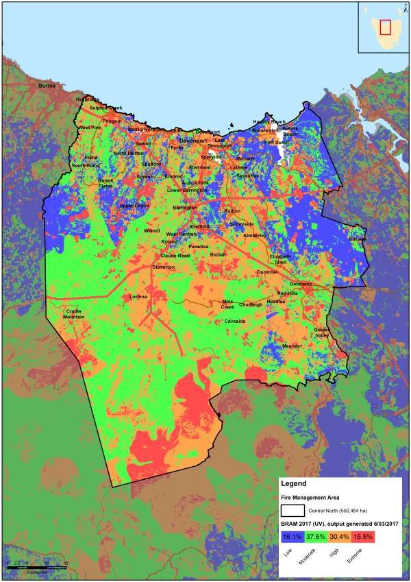
Document Control
Document History
Version                  Date               Author     Section

1.0                      19 October 2016    M Lorang   Draft
2.0                      21 December 2016   C Moore    Final
3.0                      1 December 2017    C Moore    Draft
4.0                      20 December 2017   C Moore    Final
5.0                      4 December 2018    C Moore    Draft
6.0                      11 December 2018   C Moore    Final

Central North Fire Management Area Committee Members
Agency                            Name
Central Coast Council             Tony King (Chair)
Devonport City Council            Kylie Lunson
Meander Valley Council            Martin Gill
Kentish Council/Latrobe Council   Gerald Monson
Latrobe Council                   Jonathan Magor
Tasmania Fire Service             Mark Brownrigg
Tasmania Fire Service             Neville Bingham
TasNetworks                       Michael Philpott
TasNetworks                       David Inglis
Hydro Tasmania                    Craig Emmett
Tas Parks & Wildlife              Eddie Staier
Tas Water                         Louise McConachie
STT                               Peter Rowlands
Tasmania Farmers and Graziers     Andrew Craigie
SES                               Wayne Richards

Document Endorsement

FMAC Chair – Tony King
Date: 12/12/2019

Accepted by State Fire Management Council

SFMC Chair – Ian Sauer
Date: 10/05/2019

Central North Fire Protection Plan 2019                          2
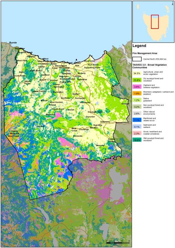
Table of Contents
Document Control ............................................................................................................ 2
Document History ......................................................................................................... 2
Central North Fire Management Area Committee Members ......................................... 2
Document Endorsement............................................................................................... 2
Glossary .......................................................................................................................... 6
Acronyms......................................................................................................................... 8
Chapter 1 Introduction ................................................................................................. 9
1.1 Background ........................................................................................................ 9
1.2 Aim and Objectives ............................................................................................ 9
1.3 Context ............................................................................................................ 10
1.4 Tenure- blind fire management approach ........................................................ 11
1.5 Policy, Standards and Legislation .................................................................... 12
Standards ............................................................................................................... 12
Legislation............................................................................................................... 12
Chapter 2 Establishing the Context ............................................................................ 13
2.1 Description of the Central North Fire Protection Plan Area .............................. 13
2.1.1 Location and Boundaries ........................................................................... 13
2.1.2 Population and Demographics .................................................................. 15
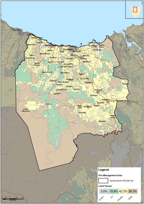
2.1.3 Land Tenure .............................................................................................. 16
2.2 Climate and Bushfire Season ........................................................................... 18
Weather Observations ............................................................................................ 18
Summary Climate Statistics – Central North FMA ................................................... 19
Temperature and rainfall ......................................................................................... 19
Wind ....................................................................................................................... 20
Bushfire season ...................................................................................................... 20
2.3 Vegetation ........................................................................................................ 21
Non native vegetation types occurring within the planning area include: ................ 21
2.4 Bushfire Frequency and Causes of Ignition .......................................................... 22
Major Fire events in the Central North FMA ............................................................ 22
Fire Ignition Cause and History ............................................................................... 22
Chapter 3 Analysing and Evaluating Bushfire Risk .................................................... 24
3.1 Analysing Bushfire Risk ................................................................................... 24
3.2 Likelihood ......................................................................................................... 24
3.3 Consequence (values at risk) ........................................................................... 25
Central North Fire Protection Plan 2019 3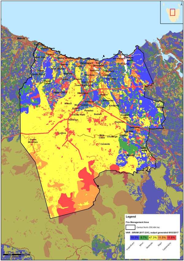
3.4      Overall Risk...................................................................................................... 25
   3.5      Risk Analysis for the Central North Fire Management Area ............................. 25
      Vulnerable Groups .................................................................................................. 30
   3.8      Areas of strategic importance within the Central North FMA ............................ 33
      Turners Beach to Leith Flood Debris....................................................................... 33
   3.9      Strategic Fuel Management ............................................................................. 33
      Strategic Fire Trails ................................................................................................. 34
Chapter 4          Bushfire Risk Treatment ............................................................................ 36
   4.1      Region Wide Controls ...................................................................................... 36
   4.2      Asset Specific Treatment Strategies ................................................................ 36
   4.3      Planned burning – treatable and untreatable locations: ................................... 36
   4.4      Treatment options other than burning .............................................................. 37
   4.5      Bushfire risk mitigation programs – other agencies .......................................... 38
      Other fire related management programs and reports: ........................................... 38
   4.6      Treatment Selection and Priorities ................................................................... 39
   4.7      Annual Implementation Program ...................................................................... 39
   4.8      Implementation ................................................................................................ 39
Chapter 5          Monitoring and Review .............................................................................. 40
   5.1      Review ............................................................................................................. 40
   5.2      Monitoring ........................................................................................................ 40
   5.3      Reporting ......................................................................................................... 40
References .................................................................................................................... 41
Appendices .................................................................................................................... 42
   Appendix 1 – Map of Central North Fire Management Area Boundary ....................... 43
   Appendix 2 – Population distribution map – Central North Fire Management Area .... 44
   Appendix 3 – Tenure map and Tables........................................................................ 45
   Appendix 4 – Vegetation Map and TasVeg community descriptions .......................... 48
   Appendix 6 - BRAM (Bushfire Risk Assessment Model) explanation ......................... 56
   Appendix 7 – NERAG risk assessment approach ...................................................... 61
   Appendix 8 – BRAM Risk Assessment Maps – Likelihood, Consequence, Risk ........ 66
   Appendix 9 – Phoenix ignition points map .................................................................. 69
   Appendix 10 – TFS Community Fire Safety Division Programs and Plans ................. 74
      1. Community Bushfire Response Plan................................................................... 74
      2. Community Bushfire Protection Plan................................................................... 74
      3. Community Bushfire Mitigation Plan ................................................................... 74
   Appendix 11 – Treatability of land within the Central North FMA ................................ 76

Central North Fire Protection Plan 2019                                                                                          4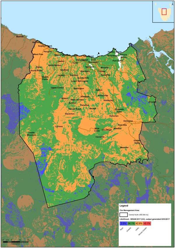
Appendix 12 - List of fire management related documents for the Central North Fire
  Management Area ...................................................................................................... 78
  Appendix 13 – Annual Implementation Program – Central North FMA 2018 .............. 80

Central North Fire Protection Plan 2019                                                                                  5
Glossary
Asset                    A term used to describe anything valued by the community that
                         may be adversely impacted by bushfire. This may include
                         residential  houses,     infrastructure, agriculture, industry,
                         environmental and heritage sites.
Asset Zone               The geographic location of asset(s) of high value or importance
                         and the physical boundary immediately around the asset.
Asset Protection         An area of high strategic importance to protect values in the asset
Zone                     zone. Regular fuel reduction should be undertaken in the vicinity of
                         specific assets. (Up to 1km wide around the asset).
Strategic Fuel           Area of management that will increase the likelihood of controlling
Reduction Zone           a bushfire within or the forward spread through the area. Located
                         strategically in fuel types of high or greater flammability. Fuel to be
                         managed by prescribed burning. Between 1km and 6km from a
                         human settlement area.
Land                     An area that is managed to meet the objectives of the relevant land
Management               manager, which can be planned fire for fuel reduction, biodiversity
Zone                     conservation or forest regeneration.

BRAM                     Bushfire Risk Assessment Model – A computer based modelling
                         tool that uses a series of inputs to assess the risk of bushfire to a
                         specific area. The BRAM has a capacity to produce a series of
                         outputs. It was developed and is managed by Tasmanian Parks &
                         Wildlife Service.
Bushfire                 Unplanned vegetation fire. A generic term which includes grass
                         fires, forest fires and scrub fires both with and without a
                         suppression objective.1
Bushfire hazard          The potential or expected behaviour of a bushfire burning under a
                         particular set of conditions, i.e. the type, arrangement and quantity
                         of fuel, the fuel moisture content, wind speed, topography, relative
                         humidity, temperature and atmospheric stability.
                         A strategic plan that focuses on addressing bushfire hazards, and
Community
Bushfire                 improving the survivability of communities and assets. The Bushfire
Mitigation Plan          Mitigation Plan identifies key areas for fuel management, and
                         provides tactical guidance regarding prescribed burning, fuel
                         treatment, fire management infrastructure, and asset protection
                         work.

Bushfire risk            A systematic process to coordinate, direct and control activities
management               relating to bushfire risk; with the aim of limiting the adverse effects
                         of bushfire on the community.

Community                A bushfire plan for community members that provides local,
Bushfire                 community-specific information to assist with bushfire preparation
Protection Plan          and survival. The focus of the Bushfire Protection Plan is on
                         bushfire safety options, and the intent of the plan is to support the

1
 Australasian Fire and Emergency Service Authorities Council 2012, AFAC Bushfire Glossary, AFAC Limited, East
Melbourne, Australia
Central North Fire Protection Plan 2019                                                                    6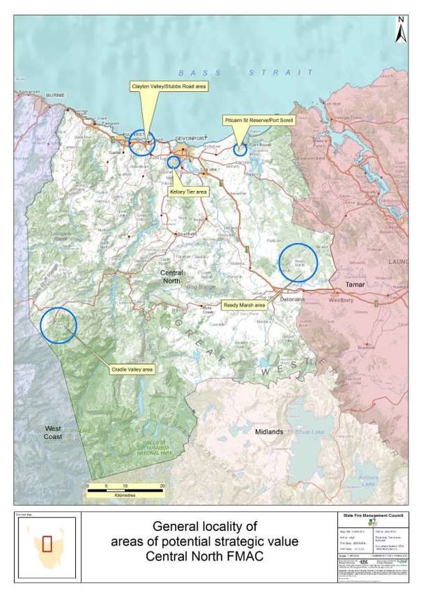
development of personal Bushfire Survival Plans.

                        An Emergency Management Plan for emergency managers and
Community
Bushfire                responders. The Bushfire Response Plan aims to better protect
Response plan           communities and their assets during bushfire emergencies, through
                        the identification of protection priorities and critical operational
                        information. These plans make firefighting resources safer and
                        more effective.

Consequence             The outcome or impact of a bushfire event.

Fire                    Classification system for the area to be managed. The zoning
management              system indicates the primary fire management purposes for an
Zoning                  area of land.

Human                   Term given for the GIS (Geographic Information Systems) dataset
Settlement Area         used to define where people live and work. The dataset was
                        developed for the purpose of risk modelling and was created using
                        a combination of building locations, cadastral information and ABS
                        data. Includes seasonally populated areas and industrial areas.
Likelihood              The chance of something occurring.
Risk                    The effect of uncertainty on objectives.2 (Note: Risk is often
                        expressed in terms of a combination of the consequences of an
                        event and the associated likelihood of occurrence.)
Risk acceptance         The informed decision to accept a risk, based on the knowledge
                        gained during the risk assessment process.
Risk analysis           The application of consequence and likelihood to an event in order
                        to determine the level of risk.
Risk assessment The systematic process of identifying, analysing and evaluating
                risk.
Risk criteria           Standards (or statements) by which the results of risk assessments
                        can be assessed. They relate quantitative risk estimates to
                        qualitative value judgements about the significance of the risks.
                        They are inexact and should be seen as guidelines rather than
                        rules.3
Risk evaluation         The process of comparing the outcomes of risk analysis to the risk
                        criteria in order to determine whether a risk is acceptable or
                        tolerable.
Risk                    The process of recognising, identifying and describing risks.
identification
Risk treatment          A process to select and implement appropriate measures
                        undertaken to modify risk.

2
  Standards Australia 2009, Risk management – Principles and guidelines, AS/NZS 31000:2009, Standards
Australia, Sydney, Australia
3
  Emergency Management Australia 1998, Australian Emergency Manuals Series – Manual 3 Australian
Management Glossary, Emergency Management Australia, Dickson, Australia
Central North Fire Protection Plan 2019                                                                 7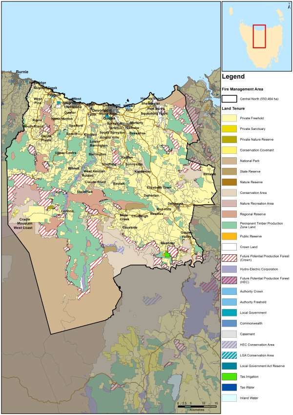
Acronyms

BPP                  Bushfire Planning & Policy

BRAM                 Bushfire Risk Assessment Model

BRN                  Bushfire Ready Neighbourhoods

CPP                  Community Protection Plan

CRP                  Community Response Plan
DPIPWE               Department of Primary Industries, Parks, Water & Environment

FIAT                 Forest Industry Association Tasmania

FMAC                 Fire Management Area Committee

FPP                  Fire Protection Plan

FRU                  Fuel Reduction Unit

HSA                  Human Settlement Area

LGA                  Local Government Area

PWS                  Parks and Wildlife Service

REMC                 Regional Emergency Management Council

SEMC                 State Emergency Management Committee

SFMC                 State Fire Management Council

STT                  Sustainable Timber Tasmania

TFGA                 Tasmania Farmers and Graziers Association

TFS                  Tasmania Fire Service

Maps contained in this document may include data provided by DPIPWE (Information
and Land Services Division (ILS), and Parks and Wildlife Service Fire Management
Section), and Tasmania Fire Service. These map products have been produced by the
Tasmania Fire Service. While all efforts have been taken to ensure the accuracy of
these products, there may be errors and/or omissions in the data presented. Users of
these products are advised to independently verify data for accuracy and completeness
prior to use.

Central North Fire Protection Plan 2019                                             8
Chapter 1 Introduction
1.1 Background
Under Section 20 of the Fire service Act 1979, fire management area committees are
required to submit to SFMC, on an annual basis, a fire protection plan for its fire
management area commencing on 1 October 2014. The submission date was changed
to the 31 December for 2016 and beyond
It is a requirement of the fire protection plan that it is consistent with the State Fire
Protection Plan and the State Vegetation Fire Management Policy.
1.2 Aim and Objectives
The management of bushfire related risk is not the sole responsibility of any one land
manager but is a collective responsibility of the whole community. All members within a
community have a responsibility to assist with the management of bushfire risk.
The aim of this FPP is to document the cross tenure process of identifying and treating
bushfire-related risk within the Central North Fire Management Area.
The objective of this FPP is to effectively manage bushfire related risk within the Central
North Fire Management Area in order to protect human life, critical infrastructure assets
and environmental values.
In the first instance, the main objective of fire protection plans is to identify risk and
provide actions for the protection of communities at risk from bushfire. Risk based
planning places the highest priority on protection of human life followed by protecting
infrastructure and environmental values.
Specifically, the objectives of this plan are to:
Guide and coordinate a tenure blind bushfire risk management program over a
five (5) year period;
Document the process used to identify, analyse and evaluate risk, determine
priorities and develop a plan to systematically treat risk;
Facilitate the effective use of the financial and physical resources available for
bushfire risk management activities;
Integrate bushfire risk management into the business processes of Local
Government, land managers and other agencies;
Ensure integration between stakeholders;
Clearly and concisely communicate risk in a format that is meaningful to
stakeholders and the community; and
Monitor and review the implementation of the Plan, to ensure enhancements are
made on an on-going basis.
Central North Fire Protection Plan 2019 9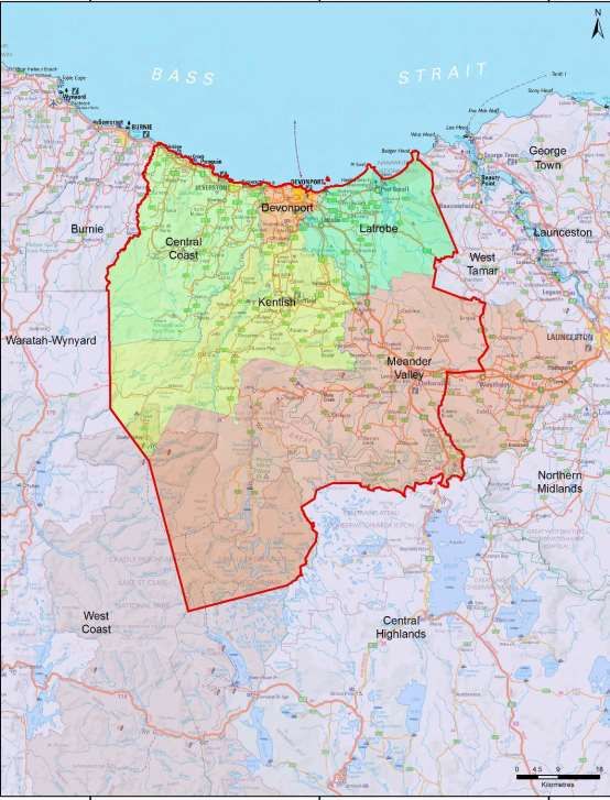
1.3 Context
South eastern Australia, including Tasmania, is particularly prone to fire and is regarded
as one of the most bushfire-affected regions in the world. Whilst bushfires are part of the
natural ecosystem processes of Tasmania and are essential for the maintenance of
biodiversity, its affects can be catastrophic if uncontrolled. Tasmania has experienced
periodic bushfire events that have caused devastating loss to life and property. In the
aftermath of recent catastrophic bushfire events a heightened focus has been placed on
bushfire risk identification and mitigation.
In recognition of the fact that bushfire is a landscape scale problem, the management of
which is a shared responsibility across all levels of government and both the public and
private arena, changes were made to the Fire Service Act 1979 that align the
administrative responsibility for the management of bushfire fuels across the State. The
fire management area committee (FMAC) structure, membership and committee
boundaries were reviewed and there are now 10 fire management areas for the State.
This reflects a broader landscape approach and strategic focus that is required to
effectively manage and mitigate the risk of bushfire.
The following organisations are represented on Fire Management Area Committees:
Local Councils
Sustainable Timber Tasmania
Tasmania Fire Service
Tasmanian Parks and Wildlife
Tasmanian Farmers and Graziers Association
Tasmanian Networks
Hydro Tasmania
Forico
TasWater
Tasmanian Land Conservancy
State Emergency Service
Department of Defence
State Fire Management Council
Natural Resource Management (NRM) organisations
The principal aim of the FMAC’s is to bring together the various stakeholders that
manage land use across the State, to work together to effectively manage vegetation
fuels for the mitigation of bushfires. The principle responsibility of a FMAC is to prepare
a fire protection plan for its Fire Management Area.
Central North Fire Protection Plan 2019 101.4 Tenure- blind fire management approach Recent bushfire events across south eastern Australia have shown the importance of strategic fuel management regardless of land tenure. The fact that bushfires move through the landscape with no regard to property boundaries or tenure means that cooperation is needed across property boundaries between land management agencies and private property owners and occupiers in order to adequately address the threat of bushfires in Tasmania. Over time the focus of fire management activities has largely ended up with government agencies managing public land. It is evident from recent fire events that focusing mitigation efforts on public land alone will not be effective in addressing the risk of bushfires. Managing the risks associated with bushfires will necessitate improving community understanding and acceptance of the need to use prescribed burning (together with a range of other treatment options) appropriately on private as well as public lands. Central North Fire Protection Plan 2019 11
1.5 Policy, Standards and Legislation
The following policy, standards and legislation were considered to be applicable to the
development and implementation of the FPP:
Tasmanian Emergency Management Plan
State Fire Protection Plan
State Vegetation Fire Management Policy
State Strategic Fuel Management Report
Northern Regional Emergency Management Plan
Municipal Emergency Management Plans
Standards
AS/NZS ISO 31000:2009 - Risk Management – Principles and Guidelines
National Emergency Risk Assessment Guidelines (NERAG)
Legislation
Aboriginal Relics Act 1975
Fire Service Act 1979
Emergency Management Act 2006
National Parks and Reserve Management Act 2002
Nature Conservation Act 2002
Crown Lands Act 1976
Forestry Act 1920 and Tasmanian Forests Agreement Act 2013
Threatened Species Protection Act 1995
Environmental Management and Pollution Control Act 1994
Local Government Act 1993
Forest Practices Act 1985 and Forest Practices Code 2000
Tasmanian Electricity Code
Central North Fire Protection Plan 2019 12Chapter 2 Establishing the Context
2.1 Description of the Central North Fire Protection Plan Area
2.1.1 Location and Boundaries
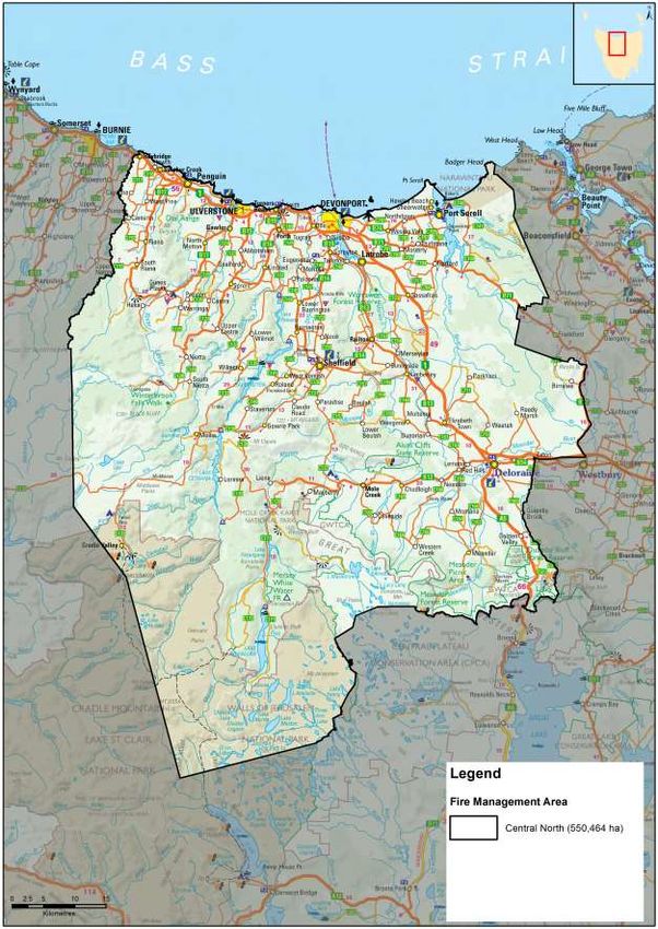
The Central North Fire Management Area is located the central north of
Tasmania and covers an area of 550,464 ha. The FMA extends westwards along
the north coast from Badger Head to Heybridge. The southern part of the FMA
extends westward from Golden Valley to the middle of Walls of Jerusalem
National Park.
It encompasses the regional centres of Devonport and Ulverstone in the north,
Sheffield and Deloraine in the southern part of the FMA. Devonport is the entry
point to Tasmania for the Spirit of Tasmania ferries which link Tasmania to
Melbourne. The Spirit of Tasmania ferries carried 433,925 passengers in
2016/2017, spending $542 million in Tasmania during that period (TT-Line
Annual Report 2016/17).
The fire management area contains a mix of fertile agricultural land, wineries,
dispersed rural communities and large areas of national park (including Mole
Creek Karst caves and The Walls of Jerusalem National Park which is part of the
Tasmanian Wilderness World Heritage Area).
The coastal area from Sassafras through to Penguin is one of Tasmania’s most
productive farming areas. The Mersey/Forth valley area (in the central north of
the FMA, surrounding the banks of the Mersey River) produces 40% of
Tasmania's vegetable crop with large areas of land covered by fields of
vegetables including onions, potatoes, peas, carrots and beans and orchard
fruits. Other important crops are poppies (grown for the pharmaceutical industry)
and pyrethrum (a botanical insecticide).
A map of the Central North Fire Management Area is contained in Appendix 1.
Central North Fire Protection Plan 2019 13There are five local government areas wholly or partially included in the Central
North fire planning area including:
Central Coast Council
Devonport City Council
Latrobe Council
Kentish Council
Meander Valley Council
Figure 1: Local government areas – Central North FMAC
Central North Fire Protection Plan 2019 142.1.2 Population and Demographics
The Central North Fire Planning Area has an estimated residential population of
82 000 people.
Devonport, with a population of 24,600 is the major regional centre within the
FMA and the surrounding region. The total population of the Central Coast
Municipality is 22,329. Other significant population centres within the FMA
include:
Ulverstone (population 12,032)
Penguin (population 3,849)
Deloraine (population 2,848)
A map showing the population distribution of the Central North Fire Management
Area is contained in Appendix 2.
Development across the fire management area is centred in the northern
(coastal) areas of the FMA. The rugged topography along the coast has resulted
in ribbon development patterns of settlement east-west along the coast and
inland, north-south along the ridge lines. Significant growth areas in the region
include;
Port Sorell, Shearwater and Hawley areas in Latrobe Council
Latrobe and Devonport have been identified by the Australian Bureau of
Statistics as experiencing population growth. Latrobe was the fastest-growing
Tasmanian LGA in 2010-11, with an increase of 2.3%.
Key industries in the area providing employment include manufacturing, retail,
agriculture, aquaculture, fishing, food and beverages industry. Secondary
industries include:
processing of agricultural products
Tourism is also an important industry.
Significant built infrastructure assets in the region include;
Origin Energy’s LPG Operation at Devonport
the Alinta gas pipeline into Tasmania at Westbury
the Devonport Airport
7 power stations
Central North Fire Protection Plan 2019 152.1.3 Land Tenure
Within the Central North FMA, approximately 58% of land is public land and 42%
is private/freehold land. The management of fire risk on private land is a
considerable challenge for the Central North FMA.
A map showing land tenure within the FMA, together with a table containing a
breakdown of land tenure in the Central North Fire Management Area is
contained in Appendix 3.
Land tenure is important when considering how to manage bushfire risk on a
landscape scale. Government agencies responsible for management of the
State’s public land generally have arrangements in place for mitigating bushfire
risk together with the resources and necessary skills for planning for and
responding to bushfire emergencies. Many private property land owners do not
have the resources, skills, knowledge or experience to safely and effectively
manage fire risk on their land. Further compounding the complex issue of
managing fire risk on private land is the fact that it is not co-ordinated or carried
out in a strategic manner.
Management of fire risk on private property
Under the Fire Service Act 1979 private landowners/occupiers in Tasmania, have
a number of legal responsibilities in relation to fire management, including
undertaking fire maintenance activities to ensure fuels on their property do not
pose a risk to neighbouring properties.
Privately owned land represents a considerable challenge to the effective
management of fire because there are currently some major barriers that limit the
extent to which landholders undertake planned burns. These include:
the risk of fire escapes. Privately owned land tends to be where the highest
value risk (human lives) are concentrated;
potential liability of property owners from fire escapes;
poor access to good weather/local forecast information;
lack of fire management knowledge, skills and experience;
lack of labour to manage the burn;
lack of appropriate equipment to safely manage the burn;
Absentee land owners - many properties now have owners but not occupiers,
for example hobby farms and holiday shack communities.
Central North Fire Protection Plan 2019 16Other (Tasmania wide) issues:
De-stocking of rural areas - land where fuels were once managed by grazing
or occasional burning, are left fallow and weeds or native vegetation fuels
accumulate.
Over time, fire preparedness and damage mitigation has given way to a
suppression-oriented approach. Communities have become reliant on fire
management agencies suppressing fire however suppression is unlikely in
extreme bushfire events.
There is an inconsistent approach amongst local Councils in relation to
enforcing fire abatement notices and provisions on private property.
There appears to be some concern and confusion in the community about a
range of fire related legal issues including vegetation clearing laws, fire
permit requirements, backyard burning restrictions and threatened species
permit requirements.
Population mobility and ageing. The number of people choosing to live in
bush-fire prone areas is increasing. As the population moves in and out of
rural areas the knowledge and awareness of people living in bush-fire prone
areas diminishes.
Land use planning issues – in some areas residential development continues
to be permitted in locations with potentially extreme fire risk.
Central North Fire Protection Plan 2019 172.2 Climate and Bushfire Season
The climate of the Central North Fire Management Area can be classified as temperate
and is characterised by warm summers and cold winters in the northern coastal parts of
the fire management area, together with mild summers and cold winters in the southern
parts of the fire management area.
Weather Observations
There are two Bureau of Meteorology (BOM) weather observation stations located within
the Central North Fire Management Area from which weather data are collected on a
regular basis. They are located at:
Devonport Airport (in the north of the fire planning area)
Sheffield (in the centre of the fire planning area)
In addition a weather station at the Forthside Research Station provides monthly
weather statistics.
Central North Fire Protection Plan 2019 18Summary Climate Statistics – Central North FMA
Mean Annual rainfall Ranges from 778mm at Devonport Airport in the northern
part of the fire management area to 1179mm in Sheffield in
the central part of the fire management area.
Wettest months Winter. Devonport receives a July average of 95mm with
Sheffield recording a July average of 157mm of rain.
Driest Months Summer. Devonport receives a February average of 37mm
of rain with Sheffield recording a January mean rainfall of
52mm.
Windiest Months Summer
Months of least wind June
Cloudiest Month May. Devonport has a mean number of 14 cloudy days in
May and Sheffield has a mean number of 13 cloudy days in
May
Temperature and rainfall
Average maximum daily temperatures within the FMA range from 21.5⁰ at Sheffield in
February to 21.6⁰ in February at Devonport Airport.
Devonport has an average minimum temperature of 4.1⁰ in July with Sheffield having an
average minimum of 2.5⁰in July.
The fire management area has a winter dominant seasonal rainfall pattern with wet
winters and low summer rainfall. Average monthly rainfall within the FMA ranges from a
low of 36mm in January in Devonport to a high of 158 mm average monthly rainfall in
Sheffield in July. The peak of the rainfall cycle in the central north occurs through
autumn to winter. The north receives shorter duration rainfall events than the west, in
mid to late autumn from moist north-easterly airstreams. Winter is the wettest season
due to the influence of passing cold frontal systems on the area.
The area has low thunderstorm and lightning activity with an average of 5 thunder days
annually.
Central North Fire Protection Plan 2019 19Figure 2: Mean annual rainfall across Tasmania Fire Management Areas.
Source: Map provided by Ian Barnes-Keogan, Bureau of Meteorology, Hobart
Wind
The prevailing winds for the area are generally from the west and northwest. Summer is
the windiest season with winds from the northwest increasing in the afternoons.
Bushfire season
A fire season is defined as the period of time in which fires are most likely to occur. Fire
seasons can vary geographically and temporally. Bushfires in Tasmania are most
commonly associated with dry conditions during summer and autumn extreme fire
conditions are not uncommon during seasons dominated by drought. Equally, fires may
occur after a short period of extreme bushfire weather that follows generally dry
conditions. The fire season in the northern region of Tasmania extends from August to
April. The fire season of the study area is generally considered to be from September to
March.
The bushfire threat for the Central North Fire Management Area increases in late
December with December/January generally being the driest and hottest months when
bushfires are more difficult to control.
Central North Fire Protection Plan 2019 202.3 Vegetation
The vegetation within a large portion of the Central North FMA has been highly modified
for agriculture resulting in the dominant vegetation type consisting of non-native
agricultural, urban and exotic vegetation. The second most common vegetation type
within the FMA consists of highly flammable dry eucalypt forest and woodland.
The main vegetation associations in Tasmania have been mapped by the TasVeg
mapping program. For the purposes of fire management, the complex vegetation
associations used in TasVeg have been simplified into 21 types and fire-attributes (fire
sensitivity and flammability ratings) have been developed for each type.
The broad native vegetation types and native forest communities occurring within the
planning area include:
Dry eucalypt forest and woodland;
Wet eucalypt forest and woodland;
Rainforest and related scrub;
Highland and treeless vegetation;
Non eucalypt forest and woodland;
Other natural environments;
Scrub, heathland and coastal complexes;
Moorland, sedgeland, rushland and peatland;
Native grassland;
Satlmarsh and wetland
Non native vegetation types occurring within the planning area include:
Agricultural, urban and exotic vegetation.
Broad Vegetation Group (TasVeg 3, (ha) % in FMA Veg
2013) Flammability
Agricultural, urban and exotic vegetation 190152 34.6 Medium
Dry eucalypt forest and woodland 129957 23.7 Medium -High
Wet eucalypt forest and woodland 107994 19.7 Medium
Rainforest and related scrub 39323 7.2 Low
Highland and Treeless Vegetation 19708 3.6 High
Non eucalypt forest and woodland 17596 3.2 High
Other natural environments 14288 2.6 N/A
Scrub, heathland and coastal complexes 12641 2.3 High – very high
Moorland, sedgeland, rushland and 10715 2.0 Low – very high
peatland
Native grassland 6472 1.2 High
Saltmarsh and wetland 649 0.1 Low
Total 549496 100
A description of each of the broad vegetation community types contained in the
TASVEG mapping dataset and found in the Central North FMA is contained in Appendix
4.
Central North Fire Protection Plan 2019 212.4 Bushfire Frequency and Causes of Ignition
Fire frequency is defined as the total number of fires that occurred over a period of time.
Fire frequency records for the Central North Fire Management Area have been obtained
from records kept by the Tasmania Fire Service, Parks and Wildlife Service and
Sustainable Timber Tasmania but are incomplete. Data for fires on private property is
particularly lacking. Records that are available indicate that the vast majority (98%) of
the fire management area has been untouched by fire in recent years. Only a very small
percentage (1.7%) of the Fire Management Area is noted as having been subject to fire
at least once in recent years. Less than 0.5% of the fire management area has been
subject to more than 2 or 3 fires at the same location.
Major Fire events in the Central North FMA
Fire name Year Area Burnt
(ha)
Lake Mackenzie Complex 2016 26109
(including Lake Bill)
Dunnings Rvt 1989 1943
Briggs Regional Reserve 2009 1794
Mt Roland 1991 626
Fire Ignition Cause and History
The true causes of fire, either through ignition by lightning or caused by human actions
have not been well documented. TFS does not keep records relating to fire ignition
causes and the causes of fire have only been documented by Tasmanian Parks and
Wildlife since the 1980s.
Of the 126 fires where ignition sources were recorded within the fire management area,
the majority of fires (35.9%) were started by arson, 10.6% were caused by escaped
planned burns, 3.5% were accidental, 1.8% were caused by lightning and in 14.8% of
cases a cause was undetermined.
Central North Fire Protection Plan 2019 22Analysis of the records that exist indicate that the principle causes of ignition (as of
December 2015) are:
Ignition source % of ignitions
Arson 35.9%
Planned burns 33.4%
Unknown cause 14.8%
Escapes from planned 10.6%
burns
Lightning 1.8%
Accident, bushfire 3.6%
spotting, campfire
(combined)
Arson appears to be a significant issue for the Central North FMA.
The 2016 wildfires were caused mostly by lightning strikes. These impacted on sensitive
highland areas that were dryer than usual due to less rainfall in the preceding years. The
figures in this paragraph and table may change after the 2016 fire season is fully
analysed.
Maps showing fire history, frequency and causes of ignition for the Central North Fire
Management Area are contained in Appendix 5.
Central North Fire Protection Plan 2019 23Chapter 3 Analysing and Evaluating Bushfire Risk 3.1 Analysing Bushfire Risk Following the Australian Standard of risk (ISO 3100) bushfire risk has been considered spatially, assessing a combination of likelihood and consequence (PWS 2011). The Bushfire Risk Assessment Model (BRAM), model data run of November 2013 was used to analyse the landscape level risk for this plan. For a full analysis of the model, see Appendix 6. To determine overall risk the NERAG (National Emergency Risk Assessment Guidelines August 2010) document (see Appendix 7) was used. The level of risk is determined by combining consequences and likelihood (see Appendix 7). It must be noted that the BRAM and therefore the consequences, likelihood and risk outputs are based on available spatial data. The analysis has been undertaken on a statewide basis, and maps are presented as complete for Tasmania. There are however gaps in the data inside and outside areas of public land. This includes fire history information, particularly on private land, which contributes to ignition potential information (likelihood), and many of the agricultural values have not been well captured (consequence). Notwithstanding these limitations, the model does provide an objective spatial analysis of bushfire risk in a landscape context. 3.2 Likelihood Likelihood is defined as a qualitative method to assess the likelihood rating to the consequences occurring. The likelihood of an event was generated by calculating ignition potential, suppression capabilities and fire behaviour potential, followed by assigning these output values to categories in a likelihood matrix. This is taken to mean the likelihood of a fire occurring in a specific area which surpasses the ability of the fire agencies to contain within the first 24 hours.206 Central North Fire Protection Plan 2019 24
3.3 Consequence (values at risk)
Consequences are defined as a qualitative rating of damage from fire to values. The
consequences were taken directly from the output generated through the Values at Risk
spatial layer output in BRAM.
Values at Risk
Agricultural values of particular significance to the Central North FMA:
seed crops such as cereals, pulses, oil seed and small seeds (i.e. pasture and
vegetable seed crops) become flammable as they ripen, and the closer to harvest
and during harvest the worse the fire danger becomes
orchards and vineyards although not normally regarded as flammable, can be
severely damaged if the weather and fire are sufficiently hot. They can be
considered high risk due to the time and investment required to establish an
orchard or vineyard to production stage and subsequently the time required to re-
establish following destruction or damaging fire events.
vineyards can be subject to smoke taint which seriously de-values wine and can
render it unsaleable.
Other values that need to be understood when examining risk include the critical
infrastructure present.
Critical infrastructure within the Central North FMA includes:
Radio Communications Towers at Kelcey Tier, Mt Claude and Dazzler Range
TasNetworks feeder lines at Woolnorth and Pieman
Orica storage facilities at Heybridge and Dulverton
Assets of particular importance to the community include:
Cradle Mountain Village and accommodation facilities (including lodges, hotels,
cottages, cabins and a caravan park (iconic tourism location which generates a
significant source of income for the region and for Tasmania)
Weegena Community hall (a central meeting place for the community)
Historic mountain huts in the Western Tiers
Petuna Seafood plant at Parramatta Creek
3.4 Overall Risk
A representation of risk (see Appendix 6) is developed when you combine the factors of
likelihood and consequence. The BRAM generated output map of risk shows qualitative
areas of risk, not areas of perceived risk.
The model assists in objectively defining areas where genuine risk is present. In-depth
analysis will indicate what factor is driving the risk for a given area.
3.5 Risk Analysis for the Central North Fire Management Area
The bushfire risk model BRAM was utilised to examine risk across the fire management
area. The results of this risk analysis are contained in a series of maps (BRAM - Bushfire
Risk Assessment Model Maps) showing likelihood of ignition, consequences and overall
risk within the Central North FMA in Appendix 8. The BRAM overall risk analysis results
for the Central North FMA are shown overleaf in Figure 3.
Central North Fire Protection Plan 2019 25A total of 20% of the fire management area was identified as being at extreme risk from
fire under current fuel loads. ** this figure has changed after new BRAM modelling –
check table below as well
BRAM Bushfire Risk Assessment results for Central North Fire Management Area:
BRAM level of Risk Area (ha) % of FMA
Low 88624 16.1%
Moderate 206974 37.6%
High 167341 30.4%
Extreme 85321 15.5%
Areas identified as being at highest risk of bushfire in the Central North FMA can be
described as being located in the central and southern area of the FMA as well as at
scattered locations throughout the FMA including in the vicinity of:
Jackeys Marsh
South of Mt Roland and Cethana to Lorinna
Eriba
Penguin
Deloraine
Mersey Lea and Kimberley
Central North Fire Protection Plan 2019 26Figure 3 – BRAM Overall Risk analysis results – Central North FMA Central North Fire Protection Plan 2019 27
3.6 Phoenix Ignition Points Modelling
In addition to BRAM modelling, Phoenix Rapidfire, a bushfire simulator, developed by
the University of Melbourne (Kevin Tolhurst and Derek Chong, 2008) was used to model
the risk of fires impacting on communities present in the FMA. An understanding of the
location of potential ignition points that may impact on communities is crucial. This
modelling was done as part of the state wide strategic fuel management assessment.
The process involved modelling potential ignition points, incorporating worst case
scenario weather patterns and examining fire behaviour based on current fuel loads to
identify the potential impact on human settlement areas.
A map showing the location of potential ignition points that may impact on communities
in the Central North FMA under current fuel loads is contained in Appendix 9.
The Phoenix modelling indicates that within the Central North FMA ignition points of
potential concern (and possibly requiring risk mitigation activities) are located:
South of Forth
West of Spreyton
South of Meander
South west and north west of Deloraine
North East of West Pine
East and south of Devonport
It must be understood that such analysis has many limitations but does provide an
indication of where communities may be under risk as well as identify areas where
strategic burning will assist in changing fire behaviour.
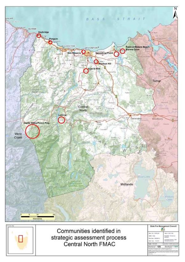
Central North Fire Protection Plan 2019 283.7 Community Risk Assessment
Strategic assessment tools (including BRAM and Phoenix computer modelling) have
been used to conduct a broad scale assessment across the Central North Fire
Management Area to identify communities vulnerable to bushfire. A more detailed
assessment using more locally specific processes was then conducted by members of
the FMAC.
Tools that were used by the FMAC to identify communities vulnerable to bushfire
include:
Consultation of Council and Emergency Services Risk Registers
Mersey District Bushfire Treatment Strategy
Local knowledge obtained from Tas Fire Service District Officers and Brigades
BRAM Risk rating for Central North Human Settlement Areas
Phoenix modelled impacts
Consultation with Tasmania Fire Service Community Protection Planners and
Community Development Officers
Expert opinion of fire practitioners
Identification and consideration of existing and past fire management actions and
plans
Communities nominated in 2014 by the Tasmania Fire Service District Officer as being
high risk within the fire management area included:
Heybridge
Squeaking Point
Summer Hill Park (Port Sorell)
Lorinna
Rubicon
Clayton Valley Stubbs Rd. (Turners Beach)
Pitcairn Reserve (Port Sorell)
Cradle Valley
Don Reserve (Devonport)
Kelcey Tier (Devonport)
Priorities identified in the Mersey District Bushfire Strategy include:
• Don Reserve (Devonport)
• Kelcey Tier (Devonport)
• Sykes Sanctuary/Railton Urban Interface
• Lorinna
• Squeaking Point
• Dooley’s Hill
Central North Fire Protection Plan 2019 29Consideration was also given to assets of particular significance to the Central North
FMA:
Agriculturally valuable locations/crops
Community assets (Historic buildings, community halls etc.)
Ecologically special areas
Major infrastructure
Large employment centres
A workshop was held in 2014 for FMAC members to discuss and analyse the results of
the preliminary risk assessment. Agreed ‘at risk’ communities were then prioritised by
members of the Central North Fire Management Area Committee.
The results of the strategic assessment for the Central North Fire Management Area are
outlined below in Table 1.
BRAM Risk FMAC priority
Human Settlement Area rating rating
Don Reserve (west of Extreme
Devonport) High
Cradle Valley (including Pencil Extreme
Pine) High
Rubicon (Bakers Beach area) High High
Heybridge High - Extreme Med-high
Lorinna (Sth of Mt Roland) High -Extreme Med
Squeaking Point High Med
Dooleys Hill (Latrobe) High Low
Acacia Hills High High
Penguin High - Extreme Low
Table 1 – Results of the Strategic Assessment – Central North FMA
A map showing the location of communities identified as a result of the strategic
assessment process is contained in Figure 4.
A number of communities already have specific bushfire response and protection plans
in place, these are summarised in Appendix 10.
Vulnerable Groups
Consideration was also given to a number of community groups and locations within the
FMA (camping areas in particular) that may contain people at risk from fire. The
following groups and locations were considered due to their isolation and close proximity
to heavily vegetated areas:
Tasmanian Devil insurance populations at Devils at Cradle (Cradle Mountain),
Trowunna Wildlife Park (Mole Creek) and Wings Wildlife Park (Gunns Plains)
The level of preparedness of residents in these areas to respond to a bushfire event is
not known. These groups and locations are likely to already have been given
consideration in Local Council Emergency Plans and associated risk assessments.
Central North Fire Protection Plan 2019 30Figure 4 – Areas Identified in FPPs for Mitigation Activities Central North Fire Protection Plan 2019 31
Figure 5 – Communities identified during strategic assessment process - Central
North FMA

Central North Fire Protection Plan 2019                                      32
3.8    Areas of strategic importance within the Central North FMA
In addition to the above communities, areas of strategic importance were also identified,
shown in Table 2. These areas were identified through a process that utilised and
combined local knowledge, BRAM risk assessment and phoenix ignition potential
modelling. FMAC members with specific fire expertise and knowledge across the area
contributed to the identification of both the communities at risk and the broader strategic
areas for potential actions.

Table 2: Strategic areas for potential treatment in the Central North FMA.

          Potential treatment area                   May provide protection for
 Clayton Valley/Stubbs Road (Turners         Turners Beach residents
 Beach)
 Reedy Marsh area                            Westbury (to the east in Tamar FMA)
 Pitcairn Street Reserve (Latrobe Council)   Residents surrounding the reserve at Port
                                             Sorrell
 Kelcey Tier (Devonport Area)                Leary Rd residents (Stony Rise) and
                                             Wrenswood Drive
 Cradle Valley                               Cradle Mountain Village
 Jackeys Marsh                               Jackeys Marsh community

A map showing areas of potential strategic value within the Central North FMA is
contained in Figure 5.

Turners Beach to Leith Flood Debris
Following significant rain events and flooding in 2016, substantial amounts of flood
debris have accumulated in the foreshore areas from Turners Beach to Leith. This debris
is on crown land and is considered to be a significant fire risk. Options to mitigate this
risk will need to be developed in conjunction with the land owners and managing
authorities. This issue was considered a high priority by the FMAC, as of December
2017 a lot of material has been removed and is now considered to be a lower risk.

3.9     Strategic Fuel Management
Reducing fuel loads in strategic areas (usually through prescribed burning) is
undertaken with the intention of modifying the fire behaviour of any future bushfire so
that there exists an improved window of opportunity to control or contain bushfire events.
The basic strategy is to develop a mosaic of fuel reduced areas within specific parts of
the landscape over a time frame of several years. The application of a burning regime
that establishes a mosaic of burns can be used to ensure bushfire impacts are
minimised. It also ensures fire dependent species are maintained. Appropriate
techniques may include but are not restricted to such processes as fuel reduction
burning, slashing and fire break construction.

Central North Fire Protection Plan 2019                                                  33
Strategic Fire Trails Strategic fire trails are trails or roads that due to their location relative to the actual or likely path of a fire and connectivity to other trail networks have the potential to provide an advantage for the purposes of fire management and control operations. To be of strategic value, fire trails should be located in the following situations: Adjacent to the assets which they are required to protect; Lead to strategic water sources; Break up large tracts of contiguous flammable vegetation; to facilitate access and egress to assets; To provide boundaries for prescribed burning blocks. The identification of strategic roads and fire trails within the Central North FMA has not yet been undertaken but has been identified as a priority in future Fire Protection Plans. Central North Fire Protection Plan 2019 34
Figure 6 – Areas of potential strategic value for mitigation activities – Central
North FMA

Central North Fire Protection Plan 2019                                        35
Chapter 4 Bushfire Risk Treatment
4.1 Region Wide Controls
The following controls are currently in place across the Central North Fire Management
Area to assist in the strategic management of bushfire related risk:
Legislative controls – including abatements, fire restrictions etc.
Public education campaigns and the use of TFS and SFMC state-wide programs
tailored to suit local needs; (eg Private land burning; Community Protection
Planning; Bushfire Ready Neighbourhoods)
State-wide arson prevention programs developed in conjunction with TAS Police
and TFS;
Setting of appropriate land subdivision and building standards in line with State
Bushfire Prone Area Building Standards;
Performance monitoring and reporting of FPP outcomes to the relevant
Emergency Management Council and State Fire Management Council as
required by the Tasmanian Emergency Management Plan and the Fire Service
Act
4.2 Asset Specific Treatment Strategies
There are five broad asset specific treatment strategies that have been used to manage
the bushfire risks identified in the Community Risk Assessment. They include:
Fuel management – Treatments include the reduction / modification of bushfire
fuels through manual, chemical and prescribed burning methods;
Ignition management - Treatments aim to reduce the occurrence of human
induced ignitions in the landscape;
Preparedness – Treatments focus on providing suitable access and water supply
arrangements that will assist with firefighting operations;
Planning – Treatments relate to the development of plans that will improve the
ability of firefighters and the community to respond to bushfire; and
Community Engagement – Treatments seek to build relationships, raise
awareness and change behaviours relating to the management of bushfire
related risks within the community.
4.3 Planned burning – treatable and untreatable locations:
Strategic fuel reduction burning is one treatment option with the potential to reduce risk
to some communities throughout the FMA.
In Tasmania, only certain types of vegetation are suitable for planned burning, for
example dry eucalypt forest, scrub, heathland and button grass. These are what can be
called ‘treatable’ vegetation types. Other vegetation types are unsuitable for planned
burning either because they are too wet to burn (such as sphagnum, swamp and
wetland), are extremely fire sensitive (rainforest, alpine/sub alpine coniferous heathland)
or have other characteristics such as land which is unvegetated or vegetation growing in
Central North Fire Protection Plan 2019 36urban areas which make them unsuitable for planned burning. These unsuitable
vegetation types are considered ‘non-treatable’ for planned burning purposes.
Agricultural lands, whilst susceptible to the impact of bushfire, are also considered ‘non -
treatable’ due to the land use priority for these vegetation types. This does not preclude
these areas from burning however it means this area of land use type is not being
included in the analysis of treatable and untreatable vegetation.
The main vegetation associations in Tasmania have been mapped by the TasVeg
mapping program. For the purposes of fire management, the complex vegetation
associations used in TasVeg have been simplified into 21 types and fire-attributes have
been developed for each type.
Approximately 41% of the area of Tasmania (or 2,760,222 ha) is covered by vegetation
types suitable for planned burning.
Within the Central North Fire Planning Area a total of 121,005 ha (or 22% of the total
area) has been categorised as Treatable. The remaining 76% of the fire planning area
(417,928 ha) has been classified as untreatable.
Fuel Reduction Burning Treatability in Central North FMAC Area
(ha) (%)
Treatable 121005 22
Un-treatable 285240 51.8
Agricultural Land* (Untreatable by fire) 132687 24.1
Water 10325 1.9
Not Mapped 1206 0.2
100.0
* Classified in TASVEG3 as 'FAG' (agricultural landscapes where there are crops, pasture or
orchards)
A map and summary table showing treatability of land within the Central North FMA is
contained in Appendix 11.
4.4 Treatment options other than burning
In areas classified as untreatable by planned burning the risk of fire may still be
mitigated through a range of other activities including:
Mechanical fuel removal (slashing and mulching, mowing, trittering, poison
spraying)
Fire trail maintenance and construction of strategic fire breaks (grading/dozing)
Intensive or ‘crash’ grazing of blocks by livestock including goats
Weed control
The creation of fuel modified zones (fuel reduced zones) around structures and
assets
Planning conditions and restrictions in areas adjoining heavily vegetated land
Bushfire resistant building design and construction materials for new
developments
Individual property bushfire readiness preparation prior to each fire season
Central North Fire Protection Plan 2019 37You can also read