2015
Torfaen County Borough Council
   Flood Risk Management Plan
←
→
Page content transcription
If your browser does not render page correctly, please read the page content below
2015 Torfaen County Borough Council Flood Risk Management Plan
Torfaen County Borough Council
                                                                 Flood Risk Management Plan

                                 Page Left Intentionally Blank

Prepared By:
Owen Griffiths
Flood Risk Officer
Highway Network
Neighbourhood Services
Torfaen County Borough Council

                                               1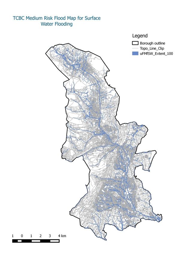
Torfaen County Borough Council
                                                                                                                          Flood Risk Management Plan

Content
1.       Introduction                                                                                                                                                   5
2.       Purpose of Flood Risk Management Plans in managing flood risk                                                                                                  6
     2.1.        What is a Flood Risk Management Plan? .............................................................................................. 6
     2.2         What is included in this FRMP ............................................................................................................... 6
     2.3         Legislative Context ................................................................................................................................ 7
     2.4         Preliminary Flood Risk Assessment ...................................................................................................... 7
     2.5         Production of flood hazard and flood risk maps for Flood Risk Areas ................................................... 8
     2.6         Flood Risk Management Plans for Flood Risk Areas. ........................................................................... 8
     2.7         Flood and Water Management Act ........................................................................................................ 8

3.       Study Area                                                                                                                                                     9
     3.1 Administrative Area....................................................................................................................................... 9

4. Flood risk in Torfaen County Borough Council                                                                                                                       12
     4.1         Summary of types of flooding present in Torfaen County Borough Council ........................................ 12
     4.2         Communities most at risk from surface water flooding in Torfaen County Borough Council ............... 14

5.       How we currently manage flood risk in Torfaen County Borough Council                                                                                         22
     5.1         How we prioritise our work................................................................................................................... 23
     5.2         Who we work with to manage flood risk in Torfaen County Borough Council ...................................... 24
     5.3         How this FRMP has been co-ordinated ............................................................................................... 25
     5.4         Measures already underway in Torfaen County Borough Council to manage flood risk...................... 26

6. Co-ordination with the Severn River Basin Management Plan and Severn River Basin District
Flood Risk Management Plan                                                                   27
7.       Torfaen County Borough Council Flood Risk Management Plan Objectives                                                                                         31
8.       How TCBC will manage flood risk at a local level                                                                                                             33
9.       Coordination with the National Strategy for flood and Coastal Erosion risk management                                                                        43
     9.1         Flood Risk Management plan Conclusions ......................................................................................... 46

10.          Public Consultation                                                                                                                                      47
11.          Monitoring and review                                                                                                                                    48
12.          References                                                                                                                                               49
     Appendix 1: Requirement of the EU Floods directive .............................................................................. 50
     Appendix 2: Flood Risk Regulations and Flood and Water Management Act 2010 ........................... 51
     Appendix 3: Contact details for Risk management authorities ............................................................... 52
     Appendix 4 Severn River Basin District Flood Risk Management Plan Measures .............................. 54
     Appendix 5 The Local Flood Risk Management Strategy Plan Objectives .......................................... 56
     Appendix 6: Ward Boundary locations ....................................................................................................... 57
     Appendix 7: TCBC updated Flood Map for Surface Water High Risk Flood Models .......................... 58
     Appendix 8: TCBC updated Flood Map for Surface Water Medium Risk Flood Models .................... 59
     Appendix 9: TCBC updated Flood Map for Surface Water Low Risk Flood Models ........................... 60
     Appendix 10: TCBC combined Flood Map for Surface Water Low, Medium and High Risk Flood
     Models ............................................................................................................................................................ 61
     Appendix 11. Flood Risk Management Plan (FRMP) Report on Consultation .................................... 62

                                                                                    2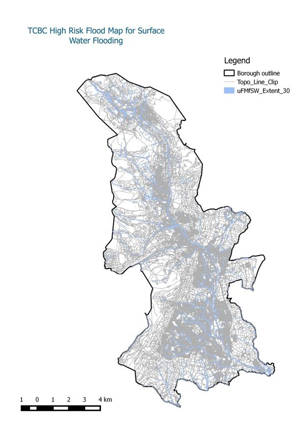
Torfaen County Borough Council
                                                             Flood Risk Management Plan

                            Tables and Figures

Tables
    Table 1     Identifying the Risk Counts made by Natural Resources        15
                Wales and JBA in 2013
    Table 2     Identifying the Low Risk to Surface Water                    16-17
                Flooding at Ward Level
    Table 3     Identifying the Medium Risk to Surface Water                 18-19
                Flooding at Ward Level
    Table 4     Identifying the High Risk to Surface Water                   20-21
                Flooding at Ward Level
    Table 5     Outlining the Primary Roles of Risk Management               24
                Authorities Operating Within TCBC
    Table 6     Local Flood Risk Management Strategy Aims                    30
    Table 7     Torfaen Count Borough Council Flood Risk Plans               37-38
                Set against the National Strategy’s four
                overreaching Objectives
    Table 8     Details of the Consultation Phase Required before            40
                Full Publication of the Flood Risk Management Plan

Figures
    Figure 1    Timescale of the Flood Risk Regulations                      7
    Figure 2    Iconic Images Blaenavon, Pontypool and Cwmbran               10
    Figure 3    Torfaen County Borough Council in context of Wales           11
    Figure 4    Map of Agreed Flood Risk Areas in England and Wales          13
    Figure 5    Torfaen County Borough Council Preliminary Flood Risk        14
                Areas
    Figure 6    Wales River Basin District Management Catchments             27
    Figure 7    Extent of Severn River Basin District                        28
    Figure 8    Summary of the Flood Risk Management Plans                   40
                Developed to Manage Flood Risk within TCBC
    Figure 9    Electoral Ward Boundaries                                    46
    Figure 10   TCBC High Risk Flood Map for Surface Water                   47
    Figure 11   TCBC Medium Risk Flood Map for Surface Water                 48
    Figure 12   TCBC Low Risk Flood Map for Surface Water                    49
    Figure 13   TCBC Combined Flood Risk Maps for                            50
                High, Medium and Low Risk

                                       3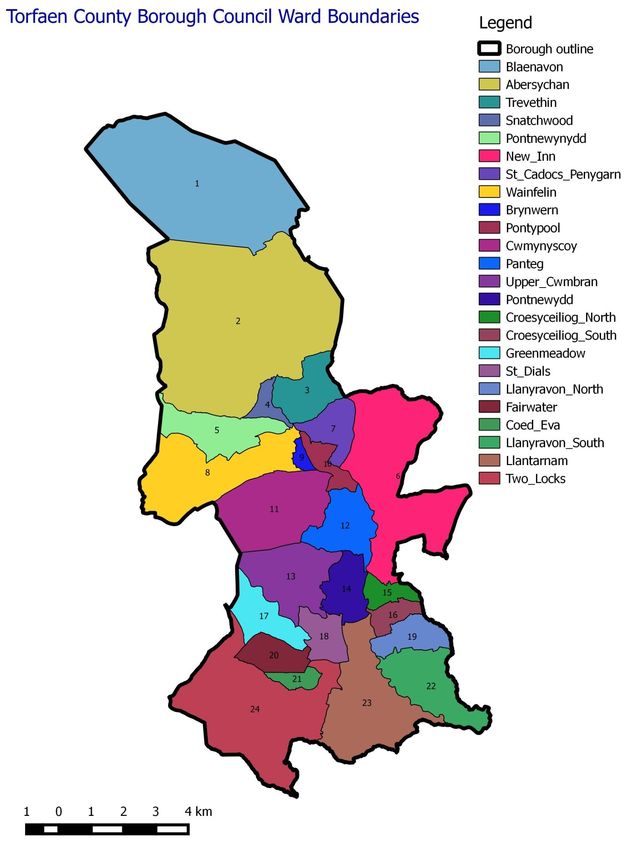
Torfaen County Borough Council
                                                      Flood Risk Management Plan

                     Glossary of Acronyms
BGS         British Geological Survey
CADW        Welsh Government
DCWW        Dwr Cymru/Welsh Water
ESDGC       Education for Sustainable Development for Global Citizenship
            Coordinators
EU          European Union
FCERM       National Strategy for Flood and Coastal Erosion Risk Management
FRA         Flood Risk Area
FRMP        Flood Risk Management Plan
FWMA 2010   Flood and Water Management Act 2010
GLRF        Gwent Local Resilience Forum
JBA         Jeremy Benn Associates Consultancy
LFRMS       Local Flood Risk Management Strategy
LLFA        Lead Local Flood Authority
NHE         Natural and Historic Environments
NHS         National Health Service
NRW         Natural Resources Wales
PBC         Property Business and Critical Service
PFRA        Preliminary Flood Risk Assessment
PLP         Property Level Protection
RMA         Risk Management Authority
SEWFRMG     South East Wales Flood Risk Management Group
SINC’s      Sites of Importance for Nature Conservation
SRBMP       Severn River Basin Management Plan
SSSI        Sites of Special Scientific Interest
SuDS        Sustainable Urban Drainage Systems
SWCF        South Wales Coal Field
SWTRA       South Wales Trunk Road Agency
TCBC        Torfaen County Borough Council
uFMfSW      Updated Flood Map for Surface Water

                                     4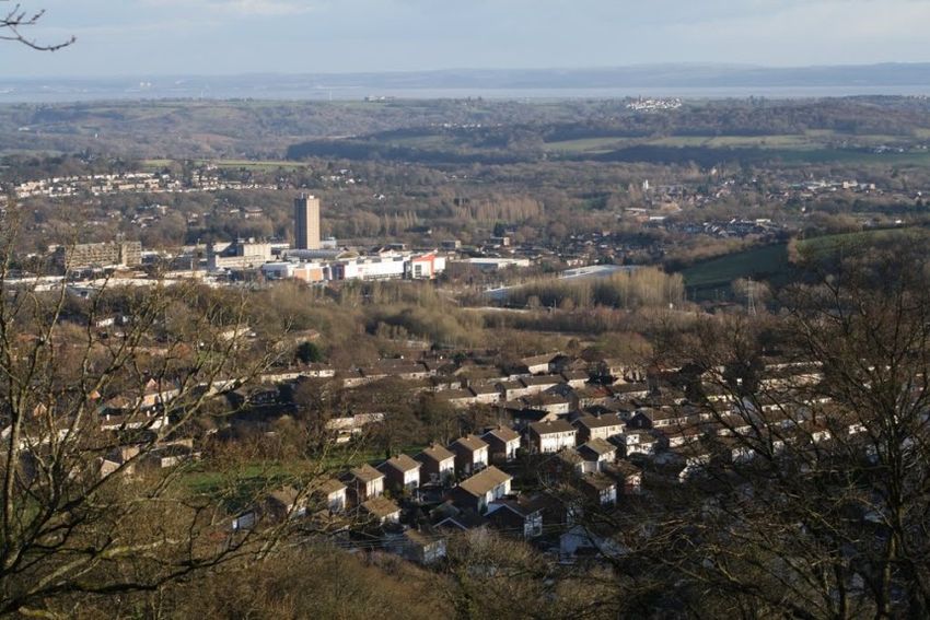
Torfaen County Borough Council
                                                                    Flood Risk Management Plan

   1. Introduction
Flood risk management is a principal idea that has been brought to the forefront of
international, national and local governments. The UK’s focus on flooding was outlined by Sir
Michael Pitt with the creation of the Pitt Review in 2008. The report was developed as a
comprehensive review of the lessons to be learned from the summer floods of 2007. It is a
inclusive report spanning 500 pages in which 92 recommendations were put forward to the
UK government. At an international level the floods directive (Directive 2007/60ec of the
European parliament and of the European council on the assessment of flood risks) was
designed to provide a universal management strategy for flood risk. The directive was
transposed into UK law by the Flood Risk Regulations 2009. The regulations placed several
requirements on local authorities identified as having a risk to flooding:

       Preliminary flood risk assessment (PFRA) maps and reports by 22 December
       2011(on the basis of which ‘Flood Risk Areas’ should be identified in accordance with
       Government guidance);

       Flood hazard maps and flood risk maps by 22 December 2013;

       Flood risk management plans (FRMP) by 22 December 2015;

       All assessments, maps and plans to be reviewed and updated every 6 years.

Further to the development of the Flood Risk Regulations the Flood and Water Management
Act 2010 was produced to provide clarity, regarding the powers and responsibilities of flood
risk management authorities. The aims of both the flood risk regulations and flood and water
management act have been designed to reduce the risk of future flooding; through the use
of a UK and indeed European standard of flood risk. The aspects of which focus upon
National strategies (Welsh Government), River Basin strategies (Natural Resources Wales)
and Local strategies (Lead Local Flood Authority) when applied to Wales.
The Flood and Water Management Act 2010 developed the principals of the flood risk
regulations and took on board many of the recommendations put forward within the Pitt
review. This new law designated local authorities as Lead Local Flood Authorities (LLFA);
and placed a responsibility for ordinary watercourses, surface and groundwater flooding. The
law designated two further risk management authorities (RMA) in relation to flooding; Natural
Resources Wales (NRW); responsible for main rivers and reservoirs and Welsh Water
(DCWW); responsible for the delivery and removal of fresh and foul water.
Through the first stage of the flood risk regulations (PFRA’s), 8 local authorities within Wales
were deemed to have significant flood risk. Torfaen is one of the 8 areas identified under the
PFRA’s with the flood risk area identified as ‘Pontypool and Cwmbran.’ The identification of
the 8 flood risk areas through the PFRA has placed a statutory responsibility onto the 8
LLFA’s making it statutory to produce the Flood Risk Management Plan’s (FRMP). However
all 22 LLFAs in Wales have opted to produce a FRMP. The FRMP is the final stage of the
Flood Risk Regulation in which Torfaen County Borough Council, as the Lead Local Flood
Authority has developed a management plan aimed at reducing the risk of flooding. The
plans have been designed utilising the Flood hazard and risk maps developed by NRW.

                                               5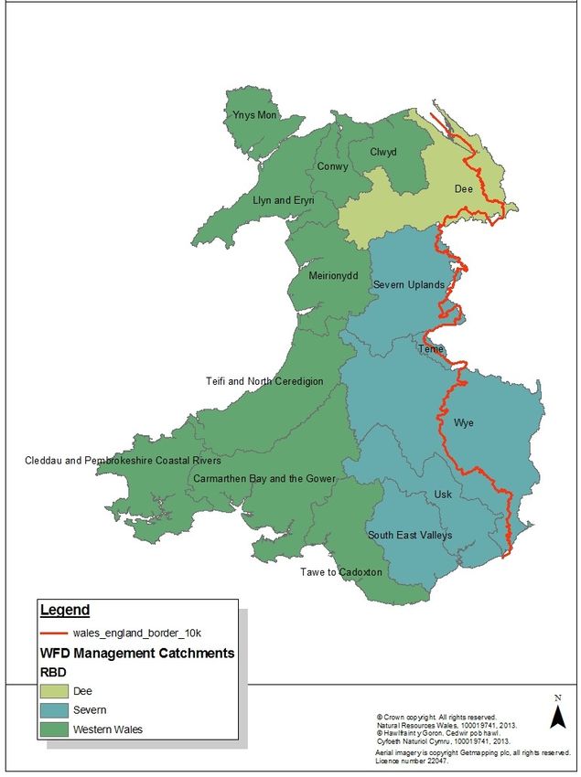
Torfaen County Borough Council
                                                                             Flood Risk Management Plan

      2. Purpose of Flood Risk Management Plans in managing flood risk

      2.1.       What is a Flood Risk Management Plan?
Flooding remains a key threat to communities across Wales, and managing this risk
through careful planning is important to minimise the risk to communities. Flood risk
management planning allows risk management authorities to develop a better understanding
of risk from all sources of flooding and agree priorities to manage that risk.
This Flood Risk Management Plan has been developed with this in mind and sets out how
Torfaen County Borough Council will over the next 6 years manage flooding so that the
communities most at risk and the environment benefit the most. In doing so, this FRMP
takes forward the objectives and actions set out in our Flood Risk Management Strategy

This FRMP also aims to achieve some of the objectives set out in the Welsh Government’s
National Flood and Coastal Erosion Risk Management Strategy1which provides the national
framework for flood and coastal erosion risk management in Wales through four overarching
objectives:

      • Reducing the consequences for individuals, communities, businesses and the
          environment from flooding and coastal erosion.

      • Raising awareness of and engaging people in the response to flood and coastal
          erosion risk.

      • Providing an effective and sustained response to flood and coastal erosion events.

      • Prioritising investment in the most at risk communities

      2.2      What is included in this FRMP

The information included in Torfaen County Borough Council FRMP includes the
components set out in the EU Flood Directive (see appendix 1). Most of this information has
been gathered and updated through this first cycle (2010 – 2016), and has been drawn from
the findings of our PFRA and the measures we identified and set out in our Local Flood Risk
Management Strategy (LFRMS).

This FRMP sets out appropriate objectives for the management of flood risk within the areas
covered by the plan. The objectives focus on reducing the adverse consequences of flooding
for human health, the environment, cultural heritage and economic activity.

To do so, this FRMP highlights the areas most at risk from surface water flooding and
ordinary watercourses in Torfaen County Borough Council, draws the conclusions from
these risks, and sets out the measures we will take over the next 6 years to mitigate these
risks and make our communities more resilient.

Due to the nature of flooding and current funding situation, we have also looked at measures
to reduce the likelihood of flooding using non-structural measures and covering all aspects of
flood risk management, including raising awareness of flooding and better understanding of

1
    http://wales.gov.uk/topics/environmentcountryside/epq/flooding/nationalstrategy/strategy/?lang=en

                                                      6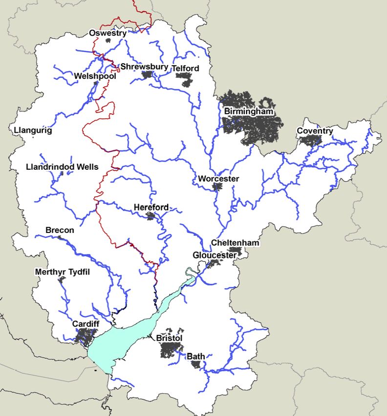
Torfaen County Borough Council
                                                                                 Flood Risk Management Plan

local flooding issues. All the measures identified in this plan have been classed in 4
categories:

      -     Prevention
      -     Protection
      -     Preparedness
      -     Recovery and Review

      2.3      Legislative Context

Under the Flood Risk Regulations 2009, Lead Local Flood Authorities (LLFAs) are
responsible for producing Flood Risk Management Plans (FRMPs) for Indicative Flood Risk
Areas that were identified in the Preliminary Flood Risk Assessments (PFRAs)2. The
legislation further provided statutory responsibilities to manage the initial production and
review process for each item of the requirements (Appendix 2).

While Natural resources Wales (NRW) is responsible for producing FRMPs at a river basin
district level for communities at risk of flooding from main rivers and the sea, LLFAs are only
required to produce local FRMPs to manage flooding from groundwater, surface water and
ordinary watercourses.

The Regulations set out a six year cycle with timescales for reporting to the European
Commission and the publication of 3 key outputs:

                              Figure 1: Flood Risk regulations (2009) Timescale

      2.4      Preliminary Flood Risk Assessment
The PFRA was a high level screening exercise that compiled information on significant local
flood risk from past and future floods, based on readily available information. The scope of
the PFRA was to consider flooding from surface runoff, ground water and ordinary
watercourses, and any interaction these sources have with main rivers with the aim of
identifying flood risk areas as set out under the European Flood Directives (see section 3.3).

2
    Indicative Flood Risk Areas have been identified where more than 5,000 people are at risk of flooding

                                                         7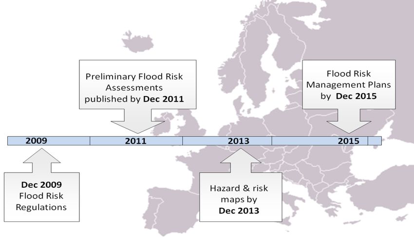
Torfaen County Borough Council
                                                                   Flood Risk Management Plan

   2.5      Production of flood hazard and flood risk maps for Flood Risk Areas
In 2013 the Environment Agency, working with Natural Resources Wales (NRW) and LLFAs,
produced the updated Flood Map for Surface Water.

The updated map represents a significant improvement on the previous surface water flood
maps (2008 and 2010), both in terms of method and representation of the risk of flooding.
The updated Flood Map for Surface Water assesses flooding scenarios as a result of rainfall
with the following chance of occurring in any given year:

         1 in 30 (3%)
         1 in 100 (1%)
         1 in 1000 (0.1%)

The updated map also provides the following data for each flooding scenario:

         Extent
         Depth
         Velocity (including flow direction at maximum velocity)
         Hazard (as a function of depth and velocity)

It also includes information about the source of the data (i.e. whether it was from the
nationally produced modelling or locally produced modelling) and the confidence in the data
outputs.

Detailed maps for areas in Torfaen can be obtained using the following link or searching
‘What’s my flood risk’ and following the Environment Agency Natural Resources Wales
web links:

http://maps.environment-
agency.gov.uk/wiyby/wiybyController?topic=floodmap&layerGroups=default&lang=_e&ep=map&sc
ale=7&x=531500&y=181500

   2.6      Flood Risk Management Plans for Flood Risk Areas.
TCBC are currently in the first cycle of the Regulations and FRMPs represent the final output
of this cycle and will be published by December 2015.

   2.7      Flood and Water Management Act
The Flood and Water Management Act 2010 was passed into law in April 2010 in England
and Wales. It was intended to implement Sir Michael Pitt’s recommendations following the
widespread flooding of 2007. The Act was also intended to clarify roles and responsibilities
between Risk Management Authorities (RMA) and established statutory responsibilities for
risk management agencies (Appendix 2).
Under the Act, the Welsh Government was required to produce a National Strategy for Flood
and Coastal Erosion Risk Management, and Torfaen County Borough Council to produce a
Local Flood Risk Management Strategy (LFRMS) which was completed in 2011.
LFRMS were created to define who the Risk Management Authorities are, what their
function is and what their responsibilities are. The LFRMS were developed to be consistent
with the National Strategy for flood and Coastal Erosion Management. Before publication the
draft version of the LFRMS underwent public scrutiny through a consultation period before
being officially published.

                                                8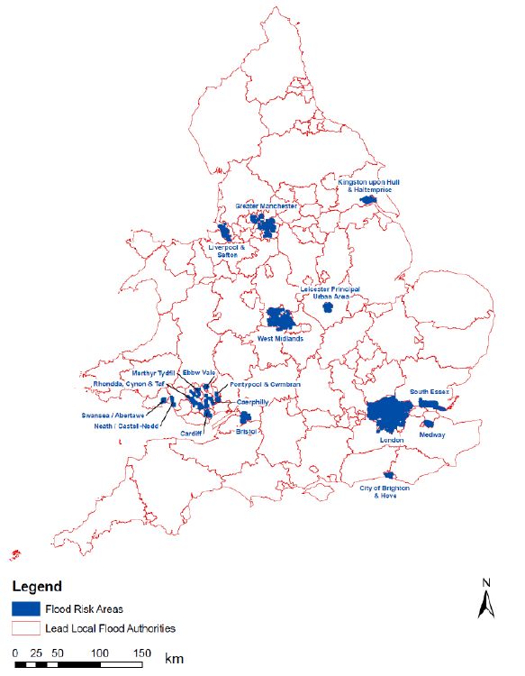
Torfaen County Borough Council
                                                                   Flood Risk Management Plan

   3. Study Area
   3.1 Administrative Area
Torfaen County Borough Council is a Unitary Authority in south east Wales. The areas of
Pontypool and Cwmbran have been designated as a flood risk area under the PFRA.
However the scope of this document looks at the flood risk for the authority as a whole. The
authority has a total population of approximately 92,000 and an area of 125 square
kilometres. The north of the County Borough encloses the river valley of the Afon Lwyd
containing the towns of Blaenavon, and Pontypool. To the south it widens to surround the
town of Cwmbran. The area is predominately urban, with the economy largely reliant on light
industry, tourism and farming.
The principal towns of TCBC have a variety of communities from the heavily developed town
of Cwmbran which was constructed as the only “New Community” to be established in
Wales under the Towns Act 1946. Work began in 1949 and finished in 1989. The population
quickly grew from 12,000 to the present 47,000 which accounts for half of the population of
the County Borough. Pontypool was a pre-existing town established in 1588 when iron
manufacturing took hold and allowed the Pontymoile area to become developed into a
suburb of Pontypool. The town grew from strength to strength through the iron industry
(Primary Sector); today the town has historical museums depicting the legacy of industry
with the secondary sector (manufacturing) taking its place, supporting a population of
28,000. Finally the World heritage site of Blaenavon; which has its history based around both
the coal and iron industry, it is evident from the heavily excavated hillsides and the world
renowned ‘Big Pit’ historical steel works and museum situated within the heart of the
heritage town. Its population is estimated at 6,000. The remaining 21,000 are found within
the smaller villages found between the larger towns.
Today’s industry can be found throughout the County Borough with larger sites towards the
south and smaller in the north ranging from aeronautical engineering to Food Suppliers.
There are 13 commercial estates throughout the County Borough which primarily support the
working population; seven of which are found throughout Cwmbran, four are found within
Pontypool and two within Blaenavon. These are a mixture of light manufacturing,
engineering and retail areas.
There are several types of critical services found throughout the Borough and these vary
considerably from gas conveyance stations, electrical sub stations, care homes, pumping
stations, and emergency service stations etc. The ownership and maintenance of these
installations fall under the respective operators that function within the Borough.
The river catchment of the Afon Llwyd has typically steep sided upper valleys and
extensively urbanised valley floors opening out into a meandering lowland river valley. The
Afon Llwyd has been described as having a flashy flow regime. This is evident when
examining the geological, topological and urban features of the Borough, where the steep
valley sides provide little opportunity for storage and interception. This allows for the
charging of the river through rapid migration of the precipitation from upland to lowland
areas. The relief of the land combined with the underlying geology is the precursor for the
lack of water storage or base flow, in very dry summers some smaller tributaries can dry up.
Within the Borough there is several abstraction licences issued to private, commercial and
industrial areas. There has been a development within Blaenavon to utilise the flow rate of
the river to generate electricity from a small scale hydroelectric generator purpose built for
the natural history museum.
The local geology is two sided where the western half of the Borough is situated on the
eastern most extent of the south wales coal field (SWCF); upper, middle and lower members
(Stratigraphical Unit) present. The Eastern Valley is composed primarily of Westphalian

                                              9
Torfaen County Borough Council
Flood Risk Management Plan
mudstones of the Marros group. There is an intersection layer between the north and south
of the valley which comprises of carboniferous limestone’s (Major Aquifer) which has
established karstic scenery on the base of the valley. The topography within TCBC provides
limited availability for storage between the valley sides resulting in limited groundwater risks,
which add to the flashy regime of surface water. However recent technological
advancements have been used to identify the risk of ‘Mine water Rebound’ within the SWCF
as a result of the shut down of all abandoned mine pumping stations. This has allowed the
mines to recharge with water and re-establish the water table. This saturation process has
increased the saturation of the bedrock and has developed a rebound within the surface.
This movement has been recorded by satellite GPS tracking over a time-lapse of several
years. This saturation has taken some time to recharge providing reduced capacity within
the available bedrocks, whilst increasing the likelihood of spring discharge from the upper
reaches of the Borough. The main river Afon Llwyd typically follows the basement limestone
resulting in limited surface water storage.
Figure 2: Principal Towns of Torfaen County Borough Council; Blaenavon (Top Left), Pontypool (Top
Right) and Cwmbran (Bottom).
10Torfaen County Borough Council
Flood Risk Management Plan
Torfaen County Borough Council in context of Wales
Blaenavon
Pontypool
Cwmbran
Figure 3: Torfaen County Borough Council Boundary map, with reference to its location on a national
scale.
11Torfaen County Borough Council
Flood Risk Management Plan
4. Flood risk in Torfaen County Borough Council
4.1 Summary of types of flooding present in Torfaen County Borough Council
Torfaen County Borough Council is subject to flooding from various sources; Riverine,
Pluvial/Surface (which encompasses ordinary watercourses), Sewer and Groundwater. The
risk of each type of flooding is different when factoring in the type of weather event (intensity
and duration), as well as the soil type, rock types and the level of urbanisation which is
evident.
Riverine flooding results from the overtopping of main watercourses; within TCBC the Main
River is that of the Afon Llwyd which runs north-south within the Borough, there is a section
of the Dowlais Brook that has been designated as Main River which feeds into the Afon
Llwyd. Main River flood risk is the responsibility of Natural Resources Wales. NRW further
have a responsibility for Reservoirs over 25,000 cubic meters, however through schedule 2
of the Flood and Water Management Act 2010 this is set to change to 10,000 cubic meters
or more.
Surface water flooding is more common within urban areas which are not obviously prone to
flooding. Surface water flooding creates issues for local authorities due to the lack of
advanced warning surrounding the phenomenon. Forecasters are unable to accurately
predict when, where and how much rainfall will be expected during the events. This is
usually down to the localised small area that is affected when heavy sporadic downpours
occur. Cwmbran witnessed a localised extreme weather event that resulted in flooding of
198 properties which was a result of surface water flooding exacerbated through the
overtopping of ordinary watercourses in May 2014.
Foul and fresh water flood risk is the responsibility of the water undertaker which falls into
the responsibility of Dwr Cymru/Welsh Water (DCCW). The foul and fresh water systems
operated by DCCW are constructed and maintained to ‘at the time current’ design standards;
currently DCWW construct to the design standards set out within Sewers for Adoptions 7th
Edition. The flooding of such features is typically caused by an increase in the water entering
into the system overloading it and causing the system to surcharge above ground creating a
surface water hazard.
Groundwater flooding occurs where water stored within the permeable layers within the
subsurface over tops the storage capacity. This is not always seen upon the valley floors but
can occur uphill from natural springs which increase the output. This type of flooding can
occur days after the initial rainfall, and is common in areas with major aquifers within the
bedrock. The South Wales coal field is regarded as a minor aquifer and the permeable
carboniferous limestone is deemed a major aquifer, despite the underlying geology
presenting ample stratigraphy to allow for high levels of groundwater, the topography of the
area having a high relief, channels the groundwater to the valley floors quickly limiting the
amount of percolation and increasing the amount of surface runoff.
There is further difficulty caused by the argillaceous upper coal measures which provide a
cap to the larger deeper carboniferous limestone. Numerous studies have been carried out
to determine the historical significance of groundwater flooding, the outcome of which has
identified the issue that Groundwater is not typically a hazard; however the implications of
wetter milder winters may cause a re-examination of the risk when technology allows a
comprehensive study of the phenomenon. Currently the British Geological Survey (BGS)
have published their first editions of susceptibility to groundwater flooding maps and are
developing the databases that support the maps. These next generation maps will likely form
part of the next iteration of the flood risk management plans.
12Torfaen County Borough Council
Flood Risk Management Plan
Map of Agreed Flood Risk areas in England and Wales
Figure 4: Details the agreed flood risk areas within England and wales, identified through the
Preliminary Flood Risk Assessments.
13Torfaen County Borough Council
Flood Risk Management Plan
Torfaen County Borough Council Preliminary Flood Risk Areas
Figure 5: Preliminary flood risk assessment output, highlighting the flood risk areas within TCBC,
taken form Torfaen County Borough Council Preliminary Flood Risk Assessment, Output produced by
NRW.
4.2 Communities most at risk from surface water flooding in Torfaen County
Borough Council
To identify risk within the authority it was deemed practical to separate the borough into
communities, however this proved difficult to identify at what scale this should be
undertaken; Town, Village, Community Council, Electoral Ward etc. The decision was made
to use Electoral Ward areas due to the level of infrastructure already in place. Council
members and residents are familiar with the spatial arrangement of these areas.
The communities designated as at risk have been determined by the high level modelling
that has taken place through the partner working between risk management authorities. The
outcomes of the modelling were extensive, determining which communities are at risk of
flooding resulted in a statistical analysis of the risk to; People, economic activity and natural
and historic environments. The initial counts were provided by NRW through the flood risk
maps produced for the Severn River Basin Management Plan.
The count methodology used by NRW was set in three stages:
High risk means that each year, there is a chance of flooding of greater than 1 in 30
(3.3%)
Medium risk means that each year, there is a chance of flooding of between 1 in 100
(1%) and 1 in 30 (3.3%)
Low risk means that each year, there is a chance of flooding of between 1 in 1000
(0.1%) and 1 in 100 (1%)
14Torfaen County Borough Council
Flood Risk Management Plan
Table identifying the Risk Counts made by Natural Resources Wales and JBA in 2013
Counts for Flood Risk Area
Risk to People and Property Total in Risk Counts
Defined
High Medium Low
Area
People 79,815 340 630 4945
Services 92 0 1 15
Risk to Economic Activity
Non Residential Properties 5607 81 112 567
Primary/Trunk Roads (Km) 19 0 0 3
Railway – Main Line (Km) 13 0 1 1
Agricultural Land Grades 1-3 911 6 4 15
Risk to Natural and Historic Environments
Bathing Waters 0 0 0 0
Environmental Permitting Regulations (EPR) 2
1 0 0
Instillations
Special Areas of Conservation (SAC) (ha) 0 0 0 0
Special Protection Areas (SPA) 0 0 0 0
Ramsar Sites (ha) 0 0 0 0
World Heritage Sites (ha) 0 0 0 0
Sights of Special Scientific Interest (SSSI) 0 0 0 0
Parks and Gardens (ha) 132 3 2 13
Scheduled Ancient Monuments (ha) 38 0 0 0
Listed Buildings 164 13 5 10
Licensed Abstractions 15 3 0 0
Table 1: Risk counts made by the Environment Agency and sourced from JBA consulting
Table 1 identifies the counts made on a county borough scale and has identified TCBC’s risk
to people, economic activity and natural and historic environments. This is a larger scale
model which doesn’t take into account local issues that surround flood risk. Although this
was a starting point for the next stage, in which TCBC have carried out an assessment of the
risk of flooding based on a 200mm depth of water at the three stages of risk used by NRW.
Following the addition of depth TCBC factored in modern day building regulations in which
door frame height was factored into the assessments; 150mm is a typical figure for the
average height of a door frame above the adjacent land. To represent this figure a 200mm
buffer was introduced to properties to reflect the 150mm height. Utilising this buffer zone and
typical depth an assumption was made:
‘Any property recognised as having 50% or more of its perimeter wetted by the
overlying flood models is deemed as being internally flooded’
The results of this spatial analysis have been depicted in Table 1 which represents the
individual wards and the combined counts (Residential Properties, Commercial Properties
and Services) set against the lowest risk factor which would represent the greatest impact.
The spatial location of the ward boundaries are depicted within Appendix 6. The spatial
representation of risk has been summarised within Appendices 4 – 7. The counts provided
for People have been done through the use of the population per dwelling average which is
nationally 2.35 per dwelling. The results for residential properties have their fore been
multiplied by 2.35 to determine the number of people at risk.
15Torfaen County Borough Council Torfaen County Borough Council
Flood Risk Management Plan Flood Risk Management Plan
Table Identifying the Levels of Low Risk Surface Water Flooding at Ward Level
Risk to People and Property Total in
GreenMeadow
Croesyceiliog
Croesyceiliog
Cwmynyscoy
Defined
Abersychan
Llantarnam
Llanyravon
Llanyravon
Area
Brynwern
Coed Eva
Fairwater
New Inn
Panteg
South
South
North
North
Risk to People In Flood Risk Area
People 79,815 85 0 55 90 15 90 60 70 265 55 235 130 75
Properties 39,000 36 0 24 37 5 38 26 30 112 23 100 54 31
Services 92 3 0 1 0 0 0 1 0 5 2 1 3 3
Risk to Economic Activity
Non Residential Properties 5607 5 0 1 3 3 5 1 0 28 7 4 11 7
Primary/Trunk Roads (Km) 35.6 2.2 1 0 0 0 1 0 0 1 0 1 0 2
Railway – Main Line (Km) 13 0 0 0 0 0 0 0 0 0 0 0 0 2
Agricultural Land Grades 1-3 19 0 0 0 1 1 0 1 0 1 1 1 1 0
Risk to Natural and Historic Environments
Bathing Waters 0 0 0 0 0 0 0 0 0 0 0 0 0 0
Environmental Permitting Regulations (EPR)
30 0 0 0 0 0 0 0 0 0 0 0 0 0
Instillations
Special Areas of Conservation (SAC) 0 0 0 0 0 0 0 0 0 0 0 0 0 0
Special Protection Areas (SPA) 0 0 0 0 0 0 0 0 0 0 0 0 0 0
Ramsar Sites 0 0 0 0 0 0 0 0 0 0 0 0 0 0
World Heritage Sites 1 0 0 0 0 0 0 0 0 0 0 0 0 0
Sights of Special Scientific Interest (SSSI) 4 0 0 0 0 0 0 0 0 0 0 0 1 0
Parks and Gardens 132 0 0 0 0 0 0 0 0 1 0 0 0 0
Scheduled Ancient Monuments 38 2 0 0 0 0 0 0 0 1 0 0 0 0
Listed Buildings 164 2 0 0 0 0 0 0 0 0 0 0 2 2
Licensed Abstractions 21 2 0 0 0 0 1 0 0 0 0 0 0 0
16Torfaen County Borough Council Torfaen County Borough Council
Flood Risk Management Plan Flood Risk Management Plan
Risk to People and Property Total in
Pontnewynydd
Defined
Snatchwood
Pontnewydd
Area
St Cadoc’s
Two Locks
Blaenavon
Pontypool
Penygran
Cwmbran
Trevethin
Wainfelin
St Dials
Upper
Risk to People In Flood Risk Area (FRA) Not in FRA
People 79,815 380 15 80 250 5 110 50 125 45 10 230
Property 39,000 161 6 34 107 1 47 21 52 19 4 96
Services 92 5 1 4 0 0 5 1 2 2 1 5
Risk to Economic Activity
Non Residential Properties 5607 29 42 13 12 0 45 4 6 1 2 50
Primary/Trunk Roads (Km) 35.6 1 0 2 2 0 1 0 0 0 2 2
Railway – Main Line (Km) 13 0 0 0 0 0 0 0 0 0 0 0
Agricultural Land Grades 1-3 19 0 0 0 0 0 0 0 1 0 0 0
Risk to Natural and Historic Environments
Bathing Waters 0 0 0 0 0 0 0 0 0 0 0 0
Environmental Permitting Regulations (EPR)
30 0 0 0 0 0 1 0 0 0 0 1
Instillations
Special Areas of Conservation (SAC) 0 0 0 0 0 0 0 0 0 0 0 0
Special Protection Areas (SPA) 0 0 0 0 0 0 0 0 0 0 0 0
Ramsar Sites 0 0 0 0 0 0 0 0 0 0 0 0
World Heritage Sites 1 0 0 0 0 0 0 0 0 0 0 1
Sights of Special Scientific Interest (SSSI) 4 0 0 0 0 0 0 0 1 0 0 1
Parks and Gardens 132 0 0 1 0 2 0 0 0 0 0 0
Scheduled Ancient Monuments 38 0 0 0 0 0 0 0 0 0 0 10
Listed Buildings 164 1 2 5 0 0 0 2 2 0 0 2
Licensed Abstractions 21 0 0 0 0 0 0 1 0 0 0 3
Table 2: Low risk results of the spatial analysis, representing the individual wards and the risk to; People, Economic Activity, Natural and Historic Environments,
produced from the Data supplied by JBA, NRW and verified by TCBC analysis.
17Torfaen County Borough Council Torfaen County Borough Council
Flood Risk Management Plan Flood Risk Management Plan
Table Identifying the Levels of Medium Risk Surface Water Flooding at Ward Level
Risk to People and Property Total in
GreenMeadow
Croesyceiliog
Croesyceiliog
Cwmynyscoy
Defined
Abersychan
Llantarnam
Llanyravon
Llanyravon
Area
Brynwern
Coed Eva
Fairwater
New Inn
Panteg
South
South
North
North
Risk to People In Flood Risk Area
People 79,815 15 0 15 15 0 55 15 15 60 10 60 10 5
Properties 39,000 6 0 6 6 0 22 5 7 25 4 24 4 2
Services 92 2 0 0 0 0 0 0 0 3 0 0 1 1
Risk to Economic Activity
Non Residential Properties 5607 0 0 0 0 0 3 0 0 5 1 1 3 0
Primary/Trunk Roads (Km) 35.6 1 1 0 0 0 0 0 0 0 0 1 0 1
Railway – Main Line (Km) 13 0 0 0 0 0 0 0 0 0 0 0 0 1
Agricultural Land Grades 1-3 19 0 0 0 0 0 0 1 0 1 1 1 1 0
Risk to Natural and Historic Environments
Bathing Waters 0 0 0 0 0 0 0 0 0 0 0 0 0 0
Environmental Permitting Regulations (EPR)
30 0 0 0 0 0 0 0 0 0 0 0 0 0
Instillations
Special Areas of Conservation (SAC) 0 0 0 0 0 0 0 0 0 0 0 0 0 0
Special Protection Areas (SPA) 0 0 0 0 0 0 0 0 0 0 0 0 0 0
Ramsar Sites 0 0 0 0 0 0 0 0 0 0 0 0 0 0
World Heritage Sites 1 0 0 0 0 0 0 0 0 0 0 0 0 0
Sights of Special Scientific Interest (SSSI) 4 0 0 0 0 0 0 0 0 0 0 0 1 0
Parks and Gardens 132 0 0 0 0 0 0 0 0 1 0 0 0 0
Scheduled Ancient Monuments 38 2 0 0 0 0 0 0 0 0 0 0 0 0
Listed Buildings 164 1 0 0 0 0 0 0 0 0 0 0 1 0
Licensed Abstractions 21 1 0 0 0 0 0 0 0 0 0 0 0 0
18Torfaen County Borough Council Torfaen County Borough Council
Flood Risk Management Plan Flood Risk Management Plan
Risk to People and Property Total in
Pontnewynydd
Defined
Snatchwood
Pontnewydd
Area
St Cadoc’s
Two Locks
Blaenavon
Pontypool
Penygran
Cwmbran
Trevethin
Wainfelin
St Dials
Upper
Risk to People In Flood Risk Area (FRA) Not in FRA
People 79,815 120 10 10 5 0 20 10 10 20 5 40
Property 39,000 51 4 3 2 0 8 4 4 8 1 16
Services 92 0 1 1 0 0 2 0 0 1 0 1
Risk to Economic Activity
Non Residential Properties 5607 4 5 1 2 0 15 1 2 1 1 14
Primary/Trunk Roads (Km) 35.6 1 0 1 1 0 1 0 0 0 0 0
Railway – Main Line (Km) 13 0 0 0 0 0 0 0 0 0 0 0
Agricultural Land Grades 1-3 19 0 0 0 0 0 0 0 1 0 0 0
Risk to Natural and Historic Environments
Bathing Waters 0 0 0 0 0 0 0 0 0 0 0 0
Environmental Permitting Regulations (EPR)
30 0 0 0 0 0 1 0 0 0 0 0
Instillations
Special Areas of Conservation (SAC) 0 0 0 0 0 0 0 0 0 0 0 0
Special Protection Areas (SPA) 0 0 0 0 0 0 0 0 0 0 0 0
Ramsar Sites 0 0 0 0 0 0 0 0 0 0 0 0
World Heritage Sites 1 0 0 0 0 0 0 0 0 0 0 1
Sights of Special Scientific Interest (SSSI) 4 0 0 0 0 0 0 0 1 0 0 1
Parks and Gardens 132 0 0 1 0 1 0 0 0 0 0 0
Scheduled Ancient Monuments 38 0 0 0 0 0 0 0 0 0 0 9
Listed Buildings 164 0 2 1 0 0 0 1 1 0 0 2
Licensed Abstractions 21 0 0 0 0 0 0 0 0 0 0 1
Table 3: Medium risk results of the spatial analysis, representing the individual wards and the risk to; People, Economic Activity, Natural and Historic Environments,
produced from the Data supplied by JBA, NRW and verified by TCBC analysis.
19Torfaen County Borough Council Torfaen County Borough Council
Flood Risk Management Plan Flood Risk Management Plan
Table Identifying the Levels of High Risk Surface Water Flooding at Ward Level
Risk to People and Property Total in
GreenMeadow
Croesyceiliog
Croesyceiliog
Cwmynyscoy
Defined
Abersychan
Llantarnam
Llanyravon
Llanyravon
Area
Brynwern
Coed Eva
Fairwater
New Inn
Panteg
South
South
North
North
Risk to People In Flood Risk Area
People 79,815 10 0 10 0 0 50 0 10 10 0 20 5 0
Properties 39,000 4 0 3 0 0 20 0 3 3 0 9 2 0
Services 92 2 0 0 0 0 0 0 0 2 0 0 1 1
Risk to Economic Activity
Non Residential Properties 5607 0 0 0 0 0 2 0 0 4 0 1 1 0
Primary/Trunk Roads (Km) 35.6 0 0 0 0 0 0 0 0 0 0 1 0 0
Railway – Main Line (Km) 13 0 0 0 0 0 0 0 0 0 0 0 0 0
Agricultural Land Grades 1-3 19 0 0 0 0 0 0 1 0 1 1 1 1 0
Risk to Natural and Historic Environments
Bathing Waters 0 0 0 0 0 0 0 0 0 0 0 0 0 0
Environmental Permitting Regulations (EPR)
30 0 0 0 0 0 0 0 0 0 0 0 0 0
Instillations
Special Areas of Conservation (SAC) 0 0 0 0 0 0 0 0 0 0 0 0 0 0
Special Protection Areas (SPA) 0 0 0 0 0 0 0 0 0 0 0 0 0 0
Ramsar Sites 0 0 0 0 0 0 0 0 0 0 0 0 0 0
World Heritage Sites 1 0 0 0 0 0 0 0 0 0 0 0 0 0
Sights of Special Scientific Interest (SSSI) 4 0 0 0 0 0 0 0 0 1 0 0 0 0
Parks and Gardens 132 0 0 0 0 0 0 0 0 1 0 0 0 0
Scheduled Ancient Monuments 38 0 0 0 0 0 0 0 0 0 0 0 0 0
Listed Buildings 164 0 0 0 0 0 0 0 0 0 0 0 1 0
Licensed Abstractions 48 0 0 0 0 0 0 0 0 0 0 0 0 0
20Torfaen County Borough Council Torfaen County Borough Council
Flood Risk Management Plan Flood Risk Management Plan
Risk to People and Property Total in
Pontnewynydd
Defined
Snatchwood
Pontnewydd
Area
St Cadoc’s
Two Locks
Blaenavon
Pontypool
Penygran
Cwmbran
Trevethin
Wainfelin
St Dials
Upper
Risk to People In Flood Risk Area (FRA) Not in FRA
People 79,815 75 0 5 5 0 5 0 0 15 0 20
Property 39,000 32 0 2 2 0 1 0 0 6 0 9
Services 92 0 0 0 0 0 0 0 0 1 0 1
Risk to Economic Activity
Non Residential Properties 5607 0 2 0 1 0 2 1 0 1 0 6
Primary/Trunk Roads (Km) 35.6 1 0 0 0 0 0 0 0 0 0 0
Railway – Main Line (Km) 13 0 0 0 0 0 0 0 0 0 0 0
Agricultural Land Grades 1-3 19 0 0 0 0 0 0 0 1 0 0 0
Risk to Natural and Historic Environments
Bathing Waters 0 0 0 0 0 0 0 0 0 0 0 0
Environmental Permitting Regulations (EPR)
30 0 0 0 0 0 0 0 0 0 0 0
Instillations
Special Areas of Conservation (SAC) 0 0 0 0 0 0 0 0 0 0 0 0
Special Protection Areas (SPA) 0 0 0 0 0 0 0 0 0 0 0 0
Ramsar Sites 0 0 0 0 0 0 0 0 0 0 0 0
World Heritage Sites 1 0 0 0 0 0 0 0 0 0 0 1
Sights of Special Scientific Interest (SSSI) 4 0 0 1 0 1 0 0 0 0 0 0
Parks and Gardens 132 0 0 1 0 1 0 0 0 0 0 0
Scheduled Ancient Monuments 38 0 0 0 0 0 0 0 0 0 0 7
Listed Buildings 164 0 2 0 0 0 0 1 1 0 0 2
Licensed Abstractions 48 0 0 0 0 0 0 0 0 0 0 0
Table 4: High risk results of the spatial analysis, representing the individual wards and the risk to; People, Economic Activity, Natural and Historic Environments,
produced from the Data supplied by JBA, NRW and verified by TCBC analysis.
21Torfaen County Borough Council
Flood Risk Management Plan
Tables 2-4 outline the flood risk counts for People, Property, Business and Environmental
and Historic sites. The tables outline the prioritisation of risk through the identification of
high, medium and Low risk by Ward areas. Table 4 identifies the highest risk areas as
Pontnewydd and Cwmynyscoy in regards to People, Property and businesses during a 3%
(1 in 30) storm event. There is low risk for Critical infrastructure, environmental and Historic
sites throughout the 24 wards during a 3% storm event.
Table 3 outlines; Pontnewydd, Llantarnam, Llanyravon South and Cwmynyscoy as the most
significant flood risk areas within the outlined FRA. The exception within the medium risk 1%
(1 in 100) storm event is the area of Blaenavon. Under the PFRA the Cwmbran and
Pontypool area was identified as the Flood Risk Area; excluding the ward of Blaenavon.
Through the detailed uFMfSW flood modelling it has been established that Blaenavon will be
incorporated into the Flood risk area and considered a significant risk based on Tables 2, 3.
The low risk 0.1% (1 in 1000) storm event (Table 2) identifies the wards; Pontnewydd,
Llantarnam, Snatchwood, Llanyravon South, and Blaenavon as having the highest number
of people and property at risk. Businesses are confined to Blaenavon, St Dials,
Pontnewynydd, Llantarnam and Pontnewydd. Similarly for the low, medium and high risk
flood models the Critical infrastructure, environmental and historic sites indicate a low risk
across the authority resulting in the prioritisation process incorporating People, Property and
businesses as the primary risk.
5. How we currently manage flood risk in Torfaen County Borough Council
TCBC has been managing the flood risk for the area since its formation in 1996; later
developments within the statute have resulted in TCBC developing the PFRA, LFRMS and
finally Flood Risk Management Plan. The LFRMS have been produced following the four
overreaching objectives of the National Strategy for Flood and Coastal Erosion Risk
Management in Wales (FCERM). From the four objectives TCBC identified 17 measures and
refined them down to 7 after they were determined to bring multiple benefits if achieved.
They were set against three types of time scales; short (0-20 years), Medium (20-50 years),
long (50-100 years).
The FWMA 2010 brought with it several duties for which LLFA’s are responsible which
include a duty to:
To develop, maintain, apply and monitor a strategy for local flood risk management in
its area.
To establish and maintain a register and record of structures or features which are
likely to have a significant effect on flood risk in its area.
On becoming aware of a flood (that satisfies trigger levels within LFRMS) in its area,
a lead local flood authority must, to the extent that it considers it necessary or
appropriate, investigate.
22Torfaen County Borough Council
Flood Risk Management Plan
Allied to the duties LLFA have been granted permissive powers through the FWMA 2010
and others including but not restricted to:
Do works to manage flood risk
To Investigate flooding incidents
To designate structures/features which affect flood risk
To Request information from a person in connection with our flood risk management
functions
Consenting organisation for land drainage consent as required under Section 23 of
the Land Drainage Act 1991.
Power to serve notice on riparian landowners along ordinary watercourses who need
to carry out maintenance to reduce flooding.
Power to serve notice on a person to abate a nuisance in relation to an ordinary
watercourse where that nuisance is an obstruction erected, raised or altered or any
culvert erected or altered without prior consent as required under Section 23 of the
Land Drainage Act 1991.
5.1 How we prioritise our work
Prioritisation of work is based around a cost benefit analysis established by Welsh
Government; this is a requirement for any works above the maintenance budget. The cost
benefit analysis is used to determine the suitability and sustainability of capital projects to
reduce risk. Welsh government have set a range of factors which will need to be considered:
Risk to life;
Longer term sustainability of the community, the approach taken and the wider
environment;
Economic impacts, costs and benefits;
Impacts of flooding on the operational capacity of critical infrastructure;
Social impacts, costs and benefits;
Frequency of flooding;
Environmental costs and benefits derived from the work;
Availability of appropriate compensation sites where work impacts designated
habitats;
Impacts on our wider cultural heritage; and
Multiple benefits in relation to human health and wellbeing.
When conducting a cost benefit analysis the risk to life is regarded as the most significant
factor in determining priority of investment. This system has been set in place to ensure the
sustainability of flood risk management throughout Wales.
23Torfaen County Borough Council
Flood Risk Management Plan
5.2 Who we work with to manage flood risk in Torfaen County Borough
Council
As described flood risk management has been established through the Flood Risk
Regulations 2009 and supplemented by the FWMA 2010. Within the Act there are
designated risk management authorities that have direct responsibilities in terms of flood risk
management; Torfaen County Borough Council has been designated as a Lead Local Flood
authority responsible for the flood risk from:
1 Ordinary watercourses (this is a watercourse that does not form part of a main river
and includes a lake, pond or other area of water, which flows into an ordinary
watercourse).
2 Surface runoff (this is rainfall or other precipitation which is on the surface or ground
and has not entered a watercourse drainage system or public sewer).
3 Ground water (this is water which has percolated into the ground and may form
underground ponds or stream which may discharge above ground but lower down
the catchment).
The Act also designates Water undertakers, in TCBC’s area DCWW take responsibility to
provide fresh and foul water to and from properties; DCWW is responsible for the risk of
flooding from public foul and storm sewer lines. Natural Resources Wales has an operational
responsibility for flooding from main rivers, the sea and coastal erosion and an oversight
responsibility in relation to all flood and coastal erosion risk management in Wales.
There are secondary risk management authorities that have an obligation to develop partner
working to manage the risk of flooding, the authorities that operate within TCBC are; Welsh
Government (CADW), SWTRA – South Wales Trunk Road Agency, Network Rail, Melin
Homes, Bron Afon, Public Health Wales, Aneurin Bevan Local Health Board, Police, Welsh
Ambulance Service NHS Trust, South Wales Fire & Rescue Service (further detailed within
Appendix 3). Their primary roles and operational areas are detailed within Table 5.
24Torfaen County Borough Council
Flood Risk Management Plan
Table Outlining the Primary Roles of Risk Management Authorities Operating Within TCBC
Authority Operational Area Primary Roles
Primary Risk Management Authorities
Monmouthshire, Newport, Protecting and reassuring the public within the operational area of
Gwent Police Torfaen, Caerphilly, Blaenau Gwent. Operating primarily in a responsive role to incidents.
Gwent
Primary role is to ensure that the environment and natural
Natural Resources
Wales resources of Wales are sustainably maintained, sustainably
Wales
enhanced and sustainably used, now and in the future.
Blaenau Gwent, Bridgend, Responsible for reducing risk through education, enforcement and
Caerphilly, Cardiff, Monmouth, response. The fire service operates in a response role to incidents.
South Wales Fire
Merthyr, Newport, Rhondda
and Rescue
Cynon Taff, Torfaen and the Vale
of Glamorgan.
Welsh Ambulance The Welsh Ambulance Service provides pre-hospital emergency
Wales
Service care and treatment throughout the Borough
Responsible for providing over three million people with a
Welsh Water/Dwr continuous, high quality supply of drinking water and for taking
Wales
Cymru away, treating and properly disposing of the wastewater that is
produced
Secondary Risk Management Authorities
Blaenau Gwent, Caerphilly, Primary agency responsible for the health and wellbeing of
Aneurin Bevan Local
Monmouthshire, Newport, residents.
Health Board
Torfaen and South Powys.
Bron Afon Responsible for energy efficient, affordable homes within Torfaen
Torfaen County Borough Council
Community Housing County Borough Council acting as a responsible landlord
Blaenau Gwent, Monmouthshire, Responsible for energy efficient, affordable homes within Torfaen
Melin Homes
Torfaen, Newport and Powys. County Borough Council acting as a responsible landlord
Operates throughout England and Aim to provide a safe, reliable and efficient railway
Network Rail
Wales
Provides professionally independent public health advice and
Public Health Wales Wales services to protect and improve the health and wellbeing of the
population of Wales.
Responsible for managing, maintaining and improving the
South Wales Trunk
South Wales motorways, trunk roads and associated assets throughout the
Road Agency
South Wales region on behalf of the Welsh Government.
Political body responsible for the allocation of funding and the
Welsh Government Wales
setting of devolved laws within Wales
Table 5: Identifies all Flood Risk Management Authorities that operate within TCBC.
5.3 How this FRMP has been co-ordinated
The FRMP has been developed in partnership with several risk management agencies
throughout south east wales (NRW, DCCW, partner Local Authorities), the main focus of
research has been directed through the Welsh Local Government Association that has
directed LLFA’s throughout south east wales in the ‘South East Wales Flood Risk
Management Group’ (SEWFRMG). This has been a platform to develop working groups, to
target the best practice approaches required to accurately advance flood risk management
plans; whilst utilising the latest technological advances to develop a comprehensive
understanding of the risk to communities. The work has been further supported by the
involvement of all LLFA’s within South East Wales, accompanied by Welsh Water, Welsh
Local Government and Natural Resources Wales representatives. The partnership working
25Torfaen County Borough Council
Flood Risk Management Plan
has been piloted through regional groups however it was Natural resources wales with JBA
Consultancy that have provided high level flood risk models from which the hazard and risk
maps presented within this report have been developed.
The detailed analysis of the flood models have been carried out by TCBC officers from
various departments within Neighbourhood Services. The assessment of which has taken
into account the suitability of the model compared to existing local knowledge and
experiences of flooding during previous events.
5.4 Measures already underway in Torfaen County Borough Council to
manage flood risk
TCBC have a number of measures in place to mitigate the risk of flooding throughout the
authority. The schemes are typically small scale aimed to reduce the impact upon a
specified number of properties with historically significant flooding, which have justified a
cost benefit for work; these range from landscaping green spaces, instigating trash/security
screens and dragon teeth around culverts and designated overland flood routes. Within the
County Borough there is a large scheme aimed at managing flood risk, the Two Locks flood
ponds was designed to manage the flow of water and reduce flooding along the Nant Y
Milwr and Dowlais Brook. This structure was constructed by the Cwmbran Development
Corporation adopted by TCBC whom currently maintain the structure.
Highway Drainage regimes have been developed to address the risk of flooding on the
highway from both culverts and gullies. A culvert maintenance schedule is carried out where
each culvert has been assigned a risk priority, which has three risk grades:
1. Highest Risk, (has caused flooding in the past)
2. Medium Risk (has not caused flooding in the past but could flood properties if
blocked)
3. Low Risk (has not caused flooding in the past but is unlikely to flood properties if
blocked)
Highway Drainage on the adopted network is managed on a risk based approach; there are
approximately 17,500 road gully drains with additional system planned to be adopted by
TCBC. The gullies on roads maintained at the public expense are inspected annually and
those drains found to have debris in them (that would cause water to flood onto the highway)
are programmed to be cleansed during this period. Any road gully drains or their associated
pipe work that are found to be damaged or blocked outside the annual schedule are
addressed on an ad hoc basis as and when they are picked up by inspection, or reported to
the Highway Authority, this may include blocked pipework which require a complete removal
of the blockage and replacement pipe to be laid.
Community engagement programmes have been developed collaboratively with Natural
Resources Wales. The scheme is based within Llanyravon south centred on the village of
Ponthir. The scheme was aimed at raising awareness of flood risk and to develop flood
warnings for property’s at risk of riverine flooding. More recent engagement has taken place
regarding the responsibility of Torfaen County Borough Council in relation to flooding; which
was distributed to the general population of TCBC through the authority’s Torfaen Talks
newspaper which is delivered quarterly to residents. The information mirrored the updated
advice related to severe weather and flooding on the authority’s website.
(http://www.torfaen.gov.uk/en/CommunityLiving/EmergencyManagement/EmergencyPlannin
g-flooding/Flooding.aspx)
26Torfaen County Borough Council
Flood Risk Management Plan
6. Co-ordination with the Severn River Basin Management Plan and
Severn River Basin District Flood Risk Management Plan
Severn River Basin Management Plan
Torfaen County Borough Councils FRMP has been directly coordinated with the Severn
River Basin Management Plan (SRBMP) developed jointly by Natural Resources Wales and
the Environment Agency. The SRBMP has been focused on the protection, improvement
and sustainable use of the water environment. This plan has been prepared under the Water
Framework Directive, which requires all countries throughout the European Union to manage
the water environment to consistent standards. Each country has to:
Prevent Deterioration in the status of aquatic ecosystems, protect them and improve
the ecological condition of waters;
Aim to achieve at least good status for all water bodies by 2015. Where this is not
possible and subject to the criteria set out in the directive, aim to achieve good status
by 2021 or 2027;
Meet the requirements of water framework directive protected areas;
Promote sustainable use of water as a natural;
Conserve habitats and species that depend directly on water;
Progressively reduce or phase out the release of individual pollutants or groups of
pollutants that present a significant threat to aquatic environment;
Progressively reduce the pollution of groundwater and prevent or limit the entry of
pollutants;
Contribute to mitigating the effects of floods and droughts.
Flood risk management is one of the top reasons why a waterbody fails to meet the objective
set under the WFD in Wales. This is why it is important to ensure that where action is
needed to manage the risk of flooding, an option is selected that does not lead to further
deterioration of the water environment but instead seeks opportunities for improvement and
delivers joint benefits.
Severn River Basin District Flood Risk Management Plan
The Severn River Basin District Flood Risk Management Plan (SFRMP) has set out 13
strategic objectives to manage the flood risk throughout the catchment. The objectives have
been strategically designed to incorporate the overreaching principals of the National
Strategies for Flood and Coastal Erosion Risk Management for England and Wales. The
objectives account for the social, economic and environmental factors affected by flood risk:
Manage flood and coastal erosion risks, taking account of the needs of communities
businesses and the environment
Reduce the risk from flooding for more households
Develop and promote a better understanding of flood and coastal risk and use this to
prioritise investment in risk management
Ensure that investment in flood and coastal risk management provides
environmental, social and economic benefits wherever possible
Target resources to reduce the risk of flooding to communities with the highest flood
risk
27You can also read